
ABSTRACT
Searching for a property is inherently a multicriteria spatial decision. The decision is primarily based on three high-level criteria composed of household needs, building facilities, and location characteristics. Location choice is driven by diverse characteristics; including but not limited to environmental factors, access, services, and the socioeconomic status of a neighbourhood. This article aims to identify the gap between theory and practice in presenting information on location choice by using a gap analysis methodology through the development of a seven-factor classification tool and an assessment of international property websites. Despite the availability of digital earth data, the results suggest that real-estate websites are poor at providing sufficient location information to support efficient spatial decision making. Based on a case study in Dublin, Ireland, we find that although neighbourhood digital earth data may be readily available to support decision making, the gap persists. We hypothesise that the reason is two-fold. Firstly, there is a technical challenge to transform location data into usable information. Secondly, the market may not wish to provide location information which can be perceived as negative. We conclude this article with a discussion of critical issues necessary for designing a spatial decision support system for real-estate decision making.
1. Introduction
Selecting a home to purchase or rent is an important multicriteria decision. From a monetary point of view, a property purchase can be the largest investment an individual can make and so carries a high financial risk. To minimise financial risks, home buyers use different sources and mechanisms such as their social network and their knowledge of the local housing market (Tu, Li, and Qiu Citation2017) to gain information to evaluate potential alternatives in terms of price, quality, and location. There are a large number of factors which influence residential choice, however, these can be broadly categorised into three interrelated classes: household needs, building facilities and location or neighbourhood characteristics (Hunt, McMillan, and Abraham Citation1994; Aliyev et al. Citation2019; McCord et al. Citation2014). In this article, location and neighbourhood have been used interchangeably.
The household characteristics are innumerable and vary from person to person and family to family. The household characteristics most relevant to the purchaser or the renter include income (Butler et al. Citation1969; Lerman Citation1976; Clark and Dieleman Citation2017), family or household size (Singell and Lillydahl Citation1986; Timmermans et al. Citation1992), occupation (Cubukgil and Miller Citation1982), life stage (Clark and Dieleman Citation2017) and education (Hill Citation1965; Frenkel, Bendit, and Kaplan Citation2013). These are factually or subjectively captured by purchasers or renters and form a conscious or passive input to the property search process.
The second criterion which is important in property selection is related to the building characteristics. For example, the price of the property (Weisbrod, Lerman, and Ben-Akiva Citation1980), the size of the property (building and lot), the number of floors, the number of rooms (specifically bedrooms and bathrooms), and the energy system (Michelsen and Madlener Citation2012). Such factors are typically objective and are easily measurable and comparable from one property to another. Describing properties using these variables is common to all real-estate platforms.
Location is the third factor which influences property choice. As Jansen and colleagues describe, location impacts on almost all aspects of life ‘Difference in location might influence various aspects, such as social status, the consumption of private goods, the availability of public goods, jobs, and other desired destinations. Location is, therefore, an important determinant of housing quality and household welfare.’ (Jansen, Coolen, and Goetgeluk Citation2011, 11). The characteristics can be specific, for example, the distance from work (Bhat and Guo Citation2007), the availability of public services (e.g. school and hospitals) (Wang and Li Citation2006), supermarkets, parks, the connectivity of the neighbourhood from an infrastructure perspective, etc. Given the dynamic variables involved, location decisions fall into the domain of complex science (Pagliara, Preston, and Simmonds Citation2010) which can be supported by the digital earth paradigm. However, the task is complicated by the number of actors including home buyers, renters, estate agents, builders, brokers, bankers, governmental and public institutes, agencies (McDonald and McMillen Citation2011), and planners (Adams and Tiesdell Citation2010) which feed into and influence the process.
Location represents the features of the neighbourhood in which a property is located. Measuring location characteristics, for example, the quality of the environment and socioeconomic conditions are difficult due to the subjectivity of the spatial extent of a neighbourhood boundary and what constitutes a good neighbourhood? Guo and Bhat identify the challenge as ‘ … how do we define neighbourhoods? or, how do we measure neighbourhood characteristics and the associated effects?’ (Guo and Bhat Citation2007, 31). In this article, we demonstrate that real-estate websites generally do not provide enough information to support spatial decision making to the fullest potential. We hypothesise that decisions are made using other data sources, external information and/or incomplete knowledge provided by real-estate platforms.
Information technology and real-estate websites are one way that many people start their residential searches; therefore, these websites play a major role in shaping residential choice (Yuan et al. Citation2013). It is therefore important that such technologies effectively provide tools to assess how a specific property can meet the interrelated household, building, and neighbourhood criteria (Baum Citation2017). Given the importance of location in residential choice, spatial data, digital earth, and maps have been shown to support efficient decision making (Jarupathirun and Zahedi Citation2005). Of course, the quality of the decisions is reliant on the quality of the underlying georeferenced data. The objective of this article is to identify and understand the gap that exists between the theoretical centrality of location and its characteristics in residential choice decision support, and the locational data that are leveraged on real-estate platforms. The main contributions of this article are:
A comprehensive review of existing scientific literature on residential property selection.
Development of a 7-factor classification tool for assessing location attributes of websites in the residential real-estate market.
A gap analysis assessment of the level of location information provided by top international real-estate websites versus the requirements identified in the scientific literature.
A case study using digital earth data for Dublin, Ireland to investigate the reason for the gap identified.
A description of potential theoretical, technological, and market challenges and solutions to enhance real-estate websites with neighbourhood information using a spatial decision support system (SDSS).
The remainder of this article is organised as follows. In the next section, a review of the academic literature on residential choice is presented. We identify the important characteristics of location and neighbourhoods which influence location choice and the spatial decision process. In Section 3, we assess 39 international real-estate platforms from a spatial lens to assess their ability to effectively support location choice. In Section 4, we investigate the availability of the required digital earth data and evaluate the possibility of reaching the desired state, which has an emphasis on location. In the concluding sections, we discuss the results and present six critical points for the design of a framework to achieve the desired characteristics of a spatial decision support system in the real-estate domain.
2. Background
Since Alonso’s early work on the bid rent theory and residential location in which he defined a meaningful relationship between the distance from the Central Business District (CBD), urban land use and residential location (Alonso Citation1964), numerous studies have examined the role of location in the real-estate market. For example, McFadden (Citation1978) identified that consumers prioritise properties based on their maximum utility, which is an optimisation of available goods or services based on consumers’ constraints such as price (McFadden Citation1978).
Traditionally, researchers used GIS with spatial analysis and statistics to integrate data from different sources (Zeng and Zhou Citation2001; Vilches-Blázquez et al. Citation2014). More recent technological advancements in software, hardware, data gathering and database management systems (Hess and Almeida Citation2007), have led to GIS and multicriteria decision analysis receiving renewed attention (Demong and Lu Citation2012). There have also been efforts to identify opportunities and challenges in using new sources of big data and digital earth data in real-estate development and marketing (Du, Li, and Zhang Citation2014; Yang et al. Citation2017) and the application of big data and cloud-based decision support in location analytics (Pick et al. Citation2017). The complexities of the multicriteria decision-making process also encompass the challenges of understanding spatial phenomena and the behavioural aspects of decision-makers (Malczewski Citation2006). Other research in this area has focused on modelling the process of decision making using agent-based simulation (Matthews et al. Citation2007), multi-agent modelling (Diappi and Bolchi Citation2008), microsimulation (Miller et al. Citation2004) and cellular automata (Stevens, Dragicevic, and Rothley Citation2007). In this article, we assess the implementation of such research within real-estate platforms.
The behaviour of buyers and renters has a crucial role in designing effective real-estate decision support systems (DSS). However, owing to the complexities of the behaviour, Johnson (Citation2005) describes how the real-estate market can seem like a ‘black box’ (Johnson Citation2005). Household, building and location characteristics each play an active role (Jansen, Coolen, and Goetgeluk Citation2011). Given the objective nature of household composition and building features, much attention has been paid to the more subjective measure of location characteristics, in particular, what determines if an area is suitable or aligned to the decision maker’s needs. Studies in this area typically examine one facet or a collection of related factors which are relevant for location choice in real-estate decisions. This article uses these to identify the gap between the literature and what is available in practice in real-estate websites.
Making purchasing decisions in housing markets ‘involves search’ which is a costly and an ‘intrinsically spatial’ decision (Sheppard Citation1999). As there is no agreed list of location characteristics in real-estate literature, we developed through an extensive literature review and classified the results. To understand the spatial characteristics which are significant in location choice, both ‘stated preference’ (Adamowicz, Louviere, and Williams Citation1994) and ‘revealed preference’ which is the result of the spatial search (Samuelson Citation1938) are used in this article to define and classify the literature on real-estate choice. From a review of the literature, location attributes were classified into seven categories (See ). These represent logical groupings of features which describe a location or neighbourhood.
Table 1: Location criteria in the real-estate market and websites (Classified by authors)
The first classification is related to the accessibility of Urban Facilities and Services . This is a primitive factor which can describe a neighbourhood. The collection of urban facilities in a location can determine its suitability for a purchaser which is linked to household factors. Urban facilities include educational centres, schools, hospitals, recreational centres, and shopping centres (Daniels Citation1985; Wang, Zheng, and Feng Citation2007). Several studies examine this characteristic of location concerning home purchase decisions. Another important characteristic identified in the literature that drives location choice is Travel Time and the associated cost of accessing other locations such as a workplace, school, and CBD (Levine Citation1998a; Waddell et al. Citation2003). The literature also shows that Price, prestige, and aesthetics of a neighbourhood are a factor considered by purchasers. The building types, rent prices, and the perceived trendiness of an area all fall into this category (Źróbek et al. Citation2015; Moriarty Citation1974; Leslie et al. Citation2007). The Quality of the Natural Environment also features as an important characteristic in the literature on home purchase decisions. This category encompasses the level of air, water, and noise pollution, the accessibility of green spaces, and the likelihood of natural hazards such as storms and earthquakes. This category is linked to the health outcomes for residents in a location (Anderson and Crocker Citation1971; Moriarty Citation1974; Koning, Filatova, and Bin Citation2018). The Security and Safety of a location also feature as a concern when performing property search. Features such as crime rate are often investigated to understand this aspect of a neighbourhood. The literature shows that people prefer locations where neighbours have similar conditions and background (Rosenbaum Citation1995; Tita, Petras, and Greenbaum Citation2006). This is often measured as the Socioeconomic Conditions or Socioeconomic Status (SES) of a location. Factors such as ethnicity, language, religion, family size, education level, etc. in a neighbourhood have an impact on where an individual will purchase a property (Bhat and Guo Citation2007; Straszhem Citation1999). Finally, Location Recommendation is desired among decision-makers and is the desired property of DSSs in the real-estate domain. Studies show that a recommendation tool which can understand the needs of the decision-maker to recommend a location or neighbourhood is desired. This also involves understanding the risk, added value, and future trend of a location (Habib and Miller Citation2009; Geltner et al. Citation2014).
These characteristics are summarised in which provides examples of how they can be measured and cites the most pertinent literature on each characteristic. The comprehensive literature review which contains the results of several surveys and questionnaires negates the need for us to freshly poll individuals regarding their approach to assessing location in the property purchases process. Instead, we can confidently rely on the findings within the studies presented here.
Given this categorisation of the location features relevant to property purchase decisions, the next section assesses the availability of these characteristics in property websites. Their availability on property websites is important given that property websites are often the starting point for property search and purchase.
3. Methodology
A property website is a business and technology-based platform and is an Internet-based version of the real-estate industry designed to link buyers and sellers. Such websites act as decision support systems which list and describe properties from sellers or estate agents and help buyers with the real-estate decision-making process. DSSs support decision-makers in solving problems (Gorry and Morton Citation1989) and SDSS uses spatial and nonspatial data to help decision-makers (Crossland Citation2008). While both systems are widely used in multiple domains (Eom et al. Citation1998; Keenan and Jankowski Citation2019) such as health (Hannah, Ball, and Berner Citation2007), water resource management (Walsh Citation1993), and urban planning (Coutinho-Rodrigues, Simão, and Antunes Citation2011) there are few proposals on how to evaluate their effectiveness (Rhee and Rao Citation2008). This is particularly true in SDSS where there are numerous factors including, the definition and objectives of the evaluation, choosing a proper methodology, and the time dependency of the process (Pick and Weatherholt Citation2012). There is no universal methodology to evaluate SDSS. Instead, we evaluated SDSSs in the real-estate domain using the seven criteria identified as relevant for location choice based on the extensive literature described in Section 2. Given the review is from an international perspective, the results are rich and sufficient to demonstrate the locational information requirements of property buyers, in general. We assess the relative ability of real-estate websites to support the seven criteria.
To create a corpus of property websites, the top 33 ranked websites listed on the Similarweb.com (https://www.similarweb.com/) directory in the Real-Estate Category were selected. Similarweb provides market analysis for multiple sectors of the digital economy. The company produces ranked lists of websites using metrics such as the number of visitors, the length of visits, the bounce rate, and traffic-share. This provides the study with a comprehensive list of property websites. Although this approach may neglect particular websites in some jurisdictions, our focus is on acquiring a list of widely used websites. Furthermore, in this study, we are not concerned with the ranking but rather with obtaining a comprehensive corpus of websites which we can analyse. We added two websites from the United Arab Emirates and South Africa from the Similarweb list to further increase the geographic coverage. As our case study presented in the next section examines data availability in Dublin, Ireland we added 4 Irish real-estate websites to link our analysis to potential data barriers in Dublin. A survey instrument was developed to assess the level of support provided by each website for the seven location categories. A six-point rating scale was used, in which 5 is the most positive outcome and demonstrates that a given website fully supports decision-makers by providing enough information to assess a category. A score of 0 indicates the website provides no support for the category. Given the complexities, including the number of websites, language barriers, and required expertise it was not possible to have multiple reviewers. Therefore, this analysis was completed by one of the authors.
4. Results
4.1 Assessment of real-estate websites
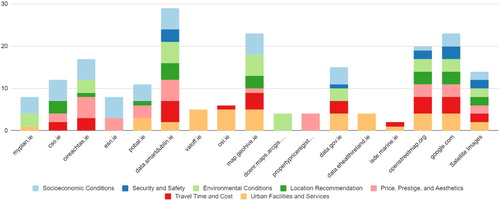
The results of the analysis can be seen in and . is a stacked column chart depicting the level of location support provided by each website using the seven-factor classification tool (criteria) developed in Section 2. This figure shows how each of the 39 websites scores relative to each of the seven criteria. The results show that the location focus of property websites is on urban facilities and services, travel time/cost, and to some extent price, aesthetic, and prestige. Most websites use external links and sources such as Google Maps and OpenStreetMap (OSM) (https://www.openstreetmap.org/) to show proximity to available urban facilities and services in a neighbourhood. Environmental information, socioeconomic status (conditions), and safety are not widely represented in the websites. Where they are present, the quality and quantity of data are insufficient to fully support decision making.
Figure 1. Stacked column chart showing the ability of 39 property websites to address the 7 key criteria for location choice (Source: By authors).
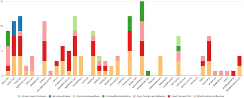
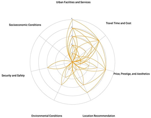
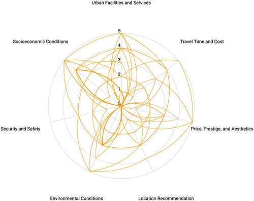
Figure 2. Radar chart showing the ability of 39 property websites to address the 7 key criteria for location choice (Source: By authors).
The use of location recommendation features is also sporadic; however, the Russian website Yandex (https://realty.yandex.ru/) provides excellent support for this objective by providing maps of locational attributes and a payback forecast.
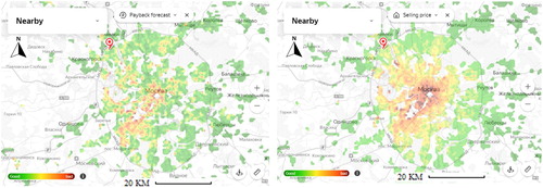
The radar chart in serves to highlight the gap that exists for several of the categories: socioeconomic conditions, safety and security, and environmental conditions. Each line on the radar chart represents a website and the distance from the origin at which each line intersects an axis indicates the extent to which a website fulfils the criterion described by the axis label. The figure shows how each criterion is covered by the selected real-estate websites from Similarweb.com. Although we have not identified individual websites in the chart, the results show that real-estate websites focus on the positive criteria of a location and avoid presenting negative location information such as crime rate or any undesirable urban features such as poor environmental conditions. The Taiwanese website, 591.com.tw (https://www.591.com.tw/), is an example of a tool which does identify places with negative attributes within a neighbourhood such as gathering points that cause traffic or noise pollution. Also, we observe that most maps and indices lack a metric and only present the locations of different urban facilities (e.g. schools and hospitals) and values (e.g. house and land prices). Some efforts can be seen in some non-English language websites such as the Russian website Yandex by presenting measured indices such as payback forecast, rental price, selling price, transport accessibility. shows two samples of these indices, which are payback forecast and selling price, but the theoretical and technical backgrounds are not well presented.
Figure 3. Samples of payback forecast and selling price maps by the Yandex website. The north arrow and an approximate scale bar were added by the authors. (Source: https://realty.yandex.ru/, Retrieval Date: 5 March 2019)
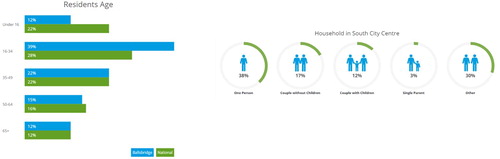
An Irish website called Myhome.ie (https://www.myhome.ie/) uses a collection of charts and numbers to present socioeconomic information of a neighbourhood or location for its users. shows two examples of graphs showing attributes of a location from this website.
Figure 4. Samples of presentation of the neighbourhood attributes from the Myhome website (Source: https://myhome.ie/ Retrieval Date: 5 March 2019).
4.2 Spatial data availability: Dublin case study
Data availability is often cited as a barrier to using spatial data (Kitchin and McArdle Citation2016). Here we investigate the availability of spatial data to support property-related decision making. In this section, we assess the availability of data against the seven factor classification tool (criteria) of location identified and developed for real-estate websites in Section 2. Dublin City was chosen as a use case for this. Dublin is representative of many mid-sized cities mainly due to its population size of 2 million and the socio-spatial inequalities which exist (Pratschke and Haase Citation2015). Furthermore, Dublin City Council promotes smart city initiatives to drive innovation through ICT (Kitchin, Maalsen, and McArdle Citation2016, 93). As a result, there should be good access to digital earth data through projects such as Smart Dublin (https://smartdublin.ie/), Dublinked (https://data.smartdublin.ie/) and the Dublin Dashboard (https://www.dublindashboard.ie/). Finally, like many cities, Dublin has a chronic housing shortage and so there is both political and general interest in the housing market.
In this section, we assess the capability of available open data sources to provide input for the seven location criteria we identified and described in Section 2. We assessed 14 official and open access data sources which were identified during the design of the Dublin Dashboard (McArdle and Kitchin Citation2016). These official data sources are governmental and local authorities such as the Economic and Social Research Institute (https://www.esri.ie/) and the Central Statistics Office (https://www.cso.ie/). Among them are two initiatives GeoHive (https://geohive.ie/) which is an initiative by Ordnance Survey Ireland (OSI) (https://www.osi.ie/) to provide easy access to spatial data, and Smart Dublin which is an initiative of the four Dublin local authorities to provide open access to data for citizens, technology providers, and researchers. Three additional sources of data were chosen as a use case for this. OSM, Google Maps, and free satellite images were also included in our analysis due to the relevant spatial data they provide. Google maps and data can be used through different platforms and/or applications such as Google Map, Google Earth, and My Google Map.
The same analysis approach that was applied to the real-estate websites in Section 3 was used. Each data source was assessed against the seven characteristics identified in Section 2. A six-point rating scale was used to describe the ability of each data source to meet the characteristics. We also used the previous visualisation method to present the results of the analysis. , a stacked column chart of available data, shows that the required data is not only provided by authorities and official data sources, but also from OSM, Google, and remotely sensed data indicating their widespread availability beyond Dublin.
Figure 5. Stacked column chart of available Data in Dublin (Source: By authors).
summarises the findings of the analysis. Each line represents one of the data sources we are studying and its ability to address the 7 criteria we have identified as important. The chart identifies that only security and safety data are not fully provided. Examining and we conclude the gap identified in Section 3 and is not rooted in data sources. Moreover, some of these data sources provide open access to almost all types of data required to improve real-estate websites with respect to location intelligence. Although we can see a shortage and weakness in the security and safety dimension, other dimensions are well covered.
Figure 6. Radar chart of available data in Dublin (Source: By authors).
5. Discussion
Our study has shown that there is a gap in the information provided on real-estate websites for location analysis. Without spatial analysis, it is not possible to provide personalised location recommendation in real-estate platforms. This study highlights that most of the real-estate companies and websites use a limited number of simple maps to display the location and value of amenities. While our methodology for selecting property websites may neglect some tools which support location choice, given that location features were not widely supported in the 39 websites which were analysed, we do not believe this is the case. By examining data availability in the Irish context, it is clear that an absence of digital earth data and information is not the root cause of this gap. There is a plethora of open data available to develop simple visualisations to provide spatial insight about different properties and neighbourhoods. This is especially true for Socioeconomic Status (SES) which did not appear as a feature in any of the websites examined. A partial shortage of information on safety and security is detected in the analysis. As well as general concerns around the validity and accuracy of crime data, it is argued that a general unwillingness to provide crime data relates to concerns of the subjectivity of identification of crime by human sensors (police) and possible underestimation of numbers due to an unwillingness of victims to report criminal incidents to the police (Scassa Citation2017). Moreover, crime data can be sensitive or classified. We are aware that crime data is available in other jurisdictions, but it is still not prevalent on property websites e.g. in the US, the Federal Bureau of Investigation (FBI) (https://www.fbi.gov/) provides open access to crime data at certain geographic levels. Volunteered Geographic Information (VGI) can play a role in filling this gap (Scassa Citation2017).
There are fundamental challenges that may impact the ability of real-estate websites to effectively present all the identified location categories detailed in Section 2. Firstly, there is a challenge to define and operationalise a neighbourhood (Chaix et al. Citation2009; Matthews Citation2016). The concept of neighbourhood is not always delimited clearly. It is often a socio-political product of sociospatial relations and activism (Martin Citation2003) rather than a clear geographical region and a neighbourhood is often different from official administrative boundaries and zones (Flowerdew, Manley, and Sabel Citation2008). Additionally, sellers may artificially change neighbourhood boundaries to affect the desirability of properties. Even if a clear boundary for a neighbourhood can be defined, the Modifiable Areal Unit Problem (MAUP) and edge and scale effects (Openshaw Citation1984) come into play which impact how the neighbourhood data can be used (Cockings et al. Citation2011). Data are not always available at the scale required for describing a neighbourhood and so complex aggregation techniques may be required (Guo and Bhat Citation2007). Furthermore, this problem of merging spatial data sources is exacerbated by the range of formats, timescales, resolutions, accuracies, access restrictions, regulation, and usage policies of the data (Fotheringham, Brunsdon, and Charlton Citation2000).
Assuming the technical aspects of defining neighbourhoods and managing data can be resolved, holistic mixed methods (quantitative and qualitative) could be used to combine different attributes of a neighbourhood. In a qualitative element, behaviour, socioeconomic, historical, and geographical processes must be considered to identify effective factors and extract relevant spatial indices. The quantitative elements must consider the geographical configuration and relations in the real-estate market. This is essential to account for the relationships between spatial variation and real-estate predictors. A natural way to describe a neighbourhood may be using composite indices. Developing such indices as black boxes is very controversial as each index requires a strong theoretical background to be accepted (OECD/JRC-European Commission Citation2008). A solution may, therefore, be dynamic indices formed from the inclusion of human-in-the-loop technologies within SDSS. Just as individuals have varied household and building requirements, preferences for what is considered a good location varies. Empowering the decision-maker with tools to express preferences such as preferring a shorter commute, to access to green space can resolve this issue.
Moreover, geodemographic segmentation including cluster typologies and maps can be another source of data for real-estate websites. Geodemographic segmentation classifies people and locations (postcodes or neighbourhoods) using multivariate statistical classification techniques, census data, and social factors and behaviours (Troy Citation2008). For example, Acorn (https://acorn.caci.co.uk/), a segmentation tool, classifies the United Kingdom into 18 groups and 62 types, a similar approach was used to classify Ireland into 17 clusters (Brunsdon, Charlton, and Rigby Citation2018). Irish property websites do not use this type of data map, which is further evidence that the existing gap is not caused by data shortages.
While, in some countries, real estate agents and sellers may be legally obliged to deliver all information of the property to buyers, our analysis has identified a potential unwillingness and resistance for real-estate websites to publish data related to the analysis of the location or neighbourhood of the property that may be perceived as negative. Property websites are commercial and produce profits by advertising properties and linking buyers and sellers and there is not necessarily an onus for an objective view to be portrayed. Property websites are an important first step in property search; but currently, the focus of real-estate websites is on presenting the information about the characteristics of the property not the location of the property. Our analysis has highlighted the importance of location characteristics in property selection. Furthermore, statutory or legal obligations of the selling agent are often disclosed at the stage when a potential buyer physically views or enquires about a property and not necessarily provided in the sales brochure or online. This challenge is difficult to overcome and may require outside intervention such as new policies, guidelines, and standards for transparency and disclosure by government or governing bodies. While this article has primarily analysed the functionality of property websites, the same websites may be assessed from the point of view of their adherence to legal and professional standards and the presentation of data.
6. Conclusion & future work
In this paper, firstly, an extensive literature review was conducted to define the most important locational or neighbourhood characteristics used in real-estate decision making. The review was used to develop a 7-factor classification tool and model of location characteristics required on real-estate websites. Secondly, a comprehensive list of international property websites listed on Similarweb.com was assessed to determine the level of location characteristics provided to their users. We identified that real-estate websites do not fully support decision-makers who use these websites for searching property online due to an absence of some location characteristics. Instead, decision-makers must seek location information such as the SES and crime rate from external sources. The property characteristics are typically well described by real-estate websites, but a comprehensive description of the neighbourhood is often missing. Thirdly, we demonstrated that data availability is not the likely cause of this deficiency by examining the availability of location/neighbourhood data in Dublin, Ireland.
Finally, we discussed technical, commercial, and socio-political constraints that need to be addressed to fill this gap. The literature is relatively clear regarding the requirements of decision-makers and a change is required to deliver these in real-estate websites. Urban dashboards have been receiving much attention and offer a partial solution. Urban dashboards are designed to display information about a city which is typically spatial. Maps, infographics, tables, and graphs objectively display information. They can operate at different spatial granularities and typically provide data based on administrative boundaries. The objective of an urban dashboard is to describe a city or an area using a set of indicators and indices. Dashboards can, therefore, be used to support property decision making. A systematic review of the available open data in Dublin was carried out when the Dublin Dashboard was being designed. Six key issues in the domains of epistemology, scope and access, veracity and validity, usability and literacy, uses and utility, and ethics were identified as requiring consideration in the development of urban dashboards (Kitchin and McArdle Citation2016). We propose that the following similar critical points should be considered in real-estate websites:
The requirements of all actors need to be understood before development.
The goals of the real-estate website need to be clearly defined before development.
The feasibility of the property tool, from a financial and technical perspective, should be understood before development.
The veracity and availability of the data need to be known in order to understand the accuracy and completeness of the data for both developers and end-users.
The motives of the developers of the property website should be presented so end-users can trust the application.
Ethical issues related to the availability and use of data within the property website need to be considered and addressed.
Similarly, at the design and technical level, general properties such as information visualisation need to be considered (Shneiderman Citation1996; Malczewski Citation1999; Rivest, Bédard, and Marchand Citation2001; Sugumaran and Degroote Citation2011). In particular, the design of interfaces to support decision making and the techniques to present and explore spatial data are important. We classified these properties for effective real-estate websites into four categories as follows:
Visualisation of Data: Websites need the ability to achieve seven main tasks: overview, zoom, filter, details-on-demand, relate, and provide a history. In addition to representing one or more measures simultaneously, visualisation of context data, and the capability to import spatial data and maps should be considered.
Exploration of Data: The availability of data exploration operations and spatio-temporal analysis functions, manipulation and calculation of different measures, filtering, and aggregation capability are required.
Structure of data: Support for seven data types: one, two, and three-dimensional data, temporal and multi-dimensional data, and tree and network data, as well as support for automatic generalisation and multiple representations, are needed.
Graphical User Interface (GUI): Tools should be interactive, easy-to-use with an ability to combine models and data, and support recovery from actions.
Addressing these technical considerations and the critical points concerning data usage can lead to property websites which begin to address the requirements presented in Section 2. To fully address them, forecasting and location recommendation support is also required. Such tools will provide better spatial insight for the decision-makers in the property domain. For example, utilising future urban development plans would also enhance real-estate decision support systems. How to incorporate these and the results of traditional modelling along with new machine learning approaches will be investigated as our study of support for real-estate decisions continues. In addition, designing and developing SDSSs which are fully functional to provide location information might be an evolutionary process by receiving feedback based on the socio-cultural context and background of potential users. User feedback can complete this process and enrich the literature and help real-estate websites to further fill the gap between theory and practice.
Acknowledgement
The authors would like to express their gratitude to the international graduate students in the UCD School of Computer Science for their help in the assessment of real estate websites in different languages. Hamidreza Rabiei-Dastjerdi is a Marie Skłodowska-Curie Career-FIT Fellow at the UCD School of Computer Science and CeADAR (Ireland’s National Centre for Applied Data Analytics & AI). Career-FIT has received funding from the European Union’s Horizon 2020 research and innovation programme under the Marie Skłodowska-Curie grant agreement No. 713654.
Disclosure statement
No potential conflict of interest was reported by the author(s).
Additional information
Funding
References
- Adamowicz, Wiktor, Jordan Louviere, and Michael Williams. 1994. “Combining Revealed and Stated Preference Methods for Valuing Environmental Amenities.” Journal of Environmental Economics and Management 26 (3): 271–292. doi: 10.1006/jeem.1994.1017
- Adams, David, and Steven Tiesdell. 2010. “Planners as Market Actors: Rethinking State–Market Relations in Land and Property.” Planning Theory & Practice 11 (2): 187–207. doi:10.1080/14649351003759631.
- Aliyev, Khatai, Mehin Amiraslanova, Nigar Bakirova, and Narmin Eynizada. 2019. “Determinants of Housing Prices in Baku: Empirical Analyses.” International Journal of Housing Markets and Analysis 12 (2): 281–297. doi:10.1108/IJHMA-08-2018-0062.
- Alonso, William. 1964. Location and Land use: Toward a General Theory of Land Rent. Publications of the Joint Center for Urban Studies of the Massachusetts Institute of Technology and Harvard University. s.l. Harvard University Press.
- Anderson Jr, Robert J., and Thomas D. Crocker. 1971. “Air Pollution and Residential Property Values.” Urban Studies 8 (3): 171–180. doi: 10.1080/00420987120080391
- Baum, Andrew. 2017. PropTech 3.0: the Future of Real Estate. Oxford: Said Business School, Oxford. https://www.sbs.ox.ac.uk/media/document/proptech-30.
- Bernknopf, Richard L., David S. Brookshire, and Mark A. Thayer. 1990. “Earthquake and Volcano Hazard Notices: An Economic Evaluation of Changes in Risk Perceptions.” Journal of Environmental Economics and Management 18 (1): 35–49. doi:10.1016/0095-0696(90)90050-9.
- Bhat, Chandra R., and Jessica Y. Guo. 2007. “A Comprehensive Analysis of Built Environment Characteristics on Household Residential Choice and Auto Ownership Levels.” Transportation Research Part B: Methodological 41 (5): 506–526. doi:10.1016/j.trb.2005.12.005.
- Bible, Douglas S., and Lawrence A. Brown. 1981. “Place Utility, Attribute Tradeoff, and Choice Behavior in an Intra-Urban Migration Context.” Socio-Economic Planning Sciences 15 (1): 37–44. doi:10.1016/0038-0121(81)90016-1.
- Bin, Okmyung, Jeffrey Czajkowski, Jingyuan Li, and Gabriele Villarini. 2017. “Housing Market Fluctuations and the Implicit Price of Water Quality: Empirical Evidence From a South Florida Housing Market.” Environ Resource Econ 68 (2): 319–341. doi: 10.1007/s10640-016-0020-8
- Brunsdon, Christopher, Martin Charlton, and Janette E. Rigby. 2018. “An Open Source Geodemographic Classification of Small Areas in the Republic of Ireland.” Applied Spatial Analysis and Policy 11 (2): 183–204. doi: 10.1007/s12061-016-9212-4
- Butler, Edgar W., F. S. Chapin, George C. Hemmens, Edward J. Kaiser, Michael A. Stegman, and Shirley F. Weiss. 1969. “Moving behavior and residential choice-a national survey.” NCHRP Report (81).
- Chaix, Basile, Juan Merlo, David Evans, Cinira Leal, and Sabrina Havard. 2009. “Neighbourhoods in eco-Epidemiologic Research: Delimiting Personal Exposure Areas. A Response to Riva, Gauvin, Apparicio and Brodeur.” Social Science & Medicine 69 (9): 1306–1310. doi: 10.1016/j.socscimed.2009.07.018
- Chen, Jie, Qianjin Hao, and Chamna Yoon. 2018. “Measuring the Welfare Cost of air Pollution in Shanghai: Evidence From the Housing Market.” Journal of Environmental Planning and Management 61 (10): 1744–1757. doi:10.1080/09640568.2017.1371581.
- Chin, Hoong C., and Kok W. Foong. 2006. “Influence of School Accessibility on Housing Values.” Journal of Urban Planning and Development 132 (3): 120–129. doi: 10.1061/(ASCE)0733-9488(2006)132:3(120)
- Clark, William A. V. 1992. “Residential Preferences and Residential Choices in a Multiethnic Context.” Demography 29 (3): 451–466. doi: 10.2307/2061828
- Clark, William A.V., and Frans M. Dieleman. 2017. Households and Housing. Routledge.
- Cockings, Samantha, Andrew Harfoot, David Martin, and Duncan Hornby. 2011. “Maintaining Existing Zoning Systems Using Automated Zone-Design Techniques: Methods for Creating the 2011 Census Output Geographies for England and Wales.” Environment and Planning A: Economy and Space 43 (10): 2399–2418. doi:10.1068/a43601.
- Coutinho-Rodrigues, João, Ana Simão, and Carlos H. Antunes. 2011. “A GIS-Based Multicriteria Spatial Decision Support System for Planning Urban Infrastructures.” Decision Support Systems 51 (3): 720–726. doi:10.1016/j.dss.2011.02.010.
- Crossland, Martin D. 2008. “Spatial Decision Support System.” In Encyclopedia of GIS, edited by Shashi Shekhar and Hui Xiong, 1095. Boston, MA: Springer US..
- Cubukgil, Adil, and Eric J. Miller. 1982. “Occupational Status and the Journey-to-Work.” Transportation 11 (3): 251–276. doi: 10.1007/BF00172652
- Czembrowski, Piotr, and Jakub Kronenberg. 2016. “Hedonic Pricing and Different Urban Green Space Types and Sizes: Insights Into the Discussion on Valuing Ecosystem Services.” Landscape and Urban Planning 146: 11–19. doi: 10.1016/j.landurbplan.2015.10.005
- Daniels, P. W. 1985. Service Industries: A Geographical Appraisal / P.W. Daniels. London: Methuen.
- Demong, Nur A. R., and Jie Lu. 2012. “Risk-based Decision Making Framework for Investment in the Real Estate Industry.” In Handbook on Decision Making, 259–283. Springer.
- Diappi, Lidia, and Paola Bolchi. 2008. “Smith’s Rent gap Theory and Local Real Estate Dynamics: A Multi-Agent Model.” Computers, Environment and Urban Systems 32 (1): 6–18. doi:10.1016/j.compenvurbsys.2006.11.003.
- Du, Danyang, Aihua Li, and Lingling Zhang. 2014. “Survey on the Applications of Big Data in Chinese Real Estate Enterprise.” Procedia Computer Science 30: 24–33. doi: 10.1016/j.procs.2014.05.377
- El-Geneidy, Ahmed, David Levinson, Ehab Diab, Genevieve Boisjoly, David Verbich, and Charis Loong. 2016. “The Cost of Equity: Assessing Transit Accessibility and Social Disparity Using Total Travel Cost.” Transportation Research Part A: Policy and Practice 91: 302–316.
- Eliasson, Jonas. 2010. “The Influence of Accessibility on Residential Location.” In Residential Location Choice, 137–64: Springer.
- Eom, S. B., S. M. Lee, E. B. Kim, and C. Somarajan. 1998. “A Survey of Decision Support System Applications (1988–1994).” Journal of the Operational Research Society 49 (2): 109–120. doi:10.1057/palgrave.jors.2600507.
- Feng, Hao, and Ming Lu. 2013. “School Quality and Housing Prices: Empirical Evidence From a Natural Experiment in Shanghai, China.” Journal of Housing Economics 22 (4): 291–307. doi:10.1016/j.jhe.2013.10.003.
- Florida, Richard. 2010. Who's Your City? How the Creative Economy is Making Where to Live the Most Important Decision of Your Life. Vintage Canada.
- Flowerdew, Robin, David J. Manley, and Clive E. Sabel. 2008. “Neighbourhood Effects on Health: Does it Matter Where you Draw the Boundaries?” Social Science & Medicine 66 (6): 1241–1255. doi: 10.1016/j.socscimed.2007.11.042
- Fotheringham, A. S., Chris Brunsdon, and Martin Charlton. 2000. Quantitative Geography: Perspectives on Spatial Data Analysis. Sage.
- Frankhauser, Pierre, and Dominique Ansel. 2016. Deciding Where to Live: An Interdisciplinary Approach to Residential Choice in Its Social Context. Wiesbaden: Springer Fachmedien Wiesbaden. http://gbv.eblib.com/patron/FullRecord.aspx?p=4684336.
- Freeman, A. M. 1981. “Hedonic Prices, Property Values and Measuring Environmental Benefits: a Survey of the Issues.” In Measurement in Public Choice, 13–32. Springer.
- Frenkel, Amnon, Edward Bendit, and Sigal Kaplan. 2013. “The Linkage Between the Lifestyle of Knowledge-Workers and Their Intra-Metropolitan Residential Choice: A Clustering Approach Based on Self-Organizing Maps.” Computers, Environment and Urban Systems 39: 151–161. doi: 10.1016/j.compenvurbsys.2012.09.001
- Geltner, David, Norman G. Miller, Jim Clayton, and Piet Eichholtz. 2014. Commercial Real Estate: Analysis and Investments. 3e. Mason, OH, USA: OnCourse Learning.
- Gilderbloom, John I., William W. Riggs, and Wesley L. Meares. 2015. “Does Walkability Matter? An Examination of Walkability’s Impact on Housing Values, Foreclosures and Crime.” Cities 42: 13–24. doi: 10.1016/j.cities.2014.08.001
- Gluszak, Michal, and Bartlomiej Marona. 2017. “Discrete Choice Model of Residential Location in Krakow.” Journal of European Real Estate Research 10 (1): 4–16. doi:10.1108/JERER-01-2016-0006.
- Gorry, G. A., and M. S. Morton. 1989. “A Framework for Management Information Systems.” Sloan Management Review 30 (3): 49–61.
- Guan, ChengHe, and Richard Peiser. 2018. “Accessibility, Urban Form, and Property Value: a Study of Pudong, Shanghai.” Journal of Transport and Land Use 11: 1. doi: 10.5198/jtlu.2018.1318
- Guerrieri, Veronica, Daniel Hartley, and Erik Hurst. 2013. “Endogenous Gentrification and Housing Price Dynamics.” Journal of Public Economics 100: 45–60. doi: 10.1016/j.jpubeco.2013.02.001
- Guo, Yuntao, Shubham Agrawal, Srinivas Peeta, and Sekhar Somenahalli. 2016. “Impacts of Property Accessibility and Neighborhood Built Environment on Single-Unit and Multiunit Residential Property Values.” Transportation Research Record: Journal of the Transportation Research Board 2568 (1): 103–112. doi:10.3141/2568-15.
- Guo, Jessica Y., and Chandra R. Bhat. 2007. “Operationalizing the Concept of Neighborhood: Application to Residential Location Choice Analysis.” Journal of Transport Geography 15 (1): 31–45. doi: 10.1016/j.jtrangeo.2005.11.001
- Habib, Muhammad A., and Eric J. Miller. 2009. “Reference-dependent Residential Location Choice Model Within a Relocation Context.” Transportation Research Record: Journal of the Transportation Research Board 2133 (1): 92–99. doi:10.3141/2133-10.
- Hallstrom, Daniel G., and V. K. Smith. 2005. “Market Responses to Hurricanes.” Journal of Environmental Economics and Management 50 (3): 541–561. doi:10.1016/j.jeem.2005.05.002.
- Han, Sun S. 2004. “Spatial Structure of Residential Property-Value Distribution in Beijing and Jakarta.” Environment and Planning A: Economy and Space 36 (7): 1259–1283. doi:10.1068/a36147.
- Hannah, Kathryn J., Marion J. Ball, and Eta S. Berner. 2007. Clinical Decision Support Systems. New York, NY: Springer New York.
- Hendricks, Andreas. 2016. Recovery from Disaster: FIG Working Week 2016: 2-6 May, Christchurch, New Zealand: Proceedings. Copenhagen: International Federation of Surveyors (FIG). http://www.fig.net/resources/proceedings/fig_proceedings/fig2016/index.htm.
- Hess, Daniel B., and Tangerine M. Almeida. 2007. “Impact of Proximity to Light Rail Rapid Transit on Station-Area Property Values in Buffalo, New York.” Urban Studies 44 (5-6): 1041–1068. doi:10.1080/00420980701256005.
- Hill, Donald M. 1965. “A Growth Allocation Model for the Eoston Region.” Journal of the American Institute of Planners 31 (2): 111–120. doi: 10.1080/01944366508978152
- Hunt, John D., J. D. P. McMillan, and John E. Abraham. 1994. “Stated Preference Investigation of Influences on Attractiveness of Residential Locations.” Transportation Research Record 1466: 79.
- Jackson, Cath, and Allison Orr. 2019. “Investment Decision-Making Under Economic Policy Uncertainty.” Journal of Property Research 36 (2): 153–185. doi:10.1080/09599916.2019.1590454.
- Jansen, Sylvia, Henny Coolen, and Roland W. Goetgeluk. 2011. The Measurement and Analysis of Housing Preference and Choice. Dordrecht: Springer.
- Jarupathirun, Suprasith, and Fatemeh Zahedi. 2005. “GIS as Spatial Decision Support Systems.” In Geographic Information Systems in Business, edited by James B. Pick, 151–174. Hershey, PA: IGI Global.
- Jim, C. Y., and Wendy Y. Chen. 2006. “Impacts of Urban Environmental Elements on Residential Housing Prices in Guangzhou (China).” Landscape and Urban Planning 78 (4): 422–434. doi:10.1016/j.landurbplan.2005.12.003.
- Johnson, Michael P. 2005. “Spatial Decision Support for Assisted Housing Mobility Counseling.” Decision Support Systems 41 (1): 296–312. doi: 10.1016/j.dss.2004.08.013
- Keenan, Peter B., and Piotr Jankowski. 2019. “Spatial Decision Support Systems: Three Decades on.” Decision Support Systems 116: 64–76. doi: 10.1016/j.dss.2018.10.010
- Kitchin, Rob, Sophia Maalsen, and Gavin McArdle. 2016. “The Praxis and Politics of Building Urban Dashboards.” Geoforum; Journal of Physical, Human, and Regional Geosciences 77: 93–101.
- Kitchin, Rob, and Gavin McArdle. 2016. Urban data and city dashboards: Six key issues.
- Knight, Jason, Russell Weaver, and Paula Jones. 2018. “Walkable and Resurgent for Whom? The Uneven Geographies of Walkability in Buffalo, NY.” Applied Geography 92: 1–11. doi: 10.1016/j.apgeog.2018.01.008
- Kok, Nils, Paavo Monkkonen, and John M. Quigley. 2014. “Land use Regulations and the Value of Land and Housing: An Intra-Metropolitan Analysis.” Journal of Urban Economics 81: 136–148. doi: 10.1016/j.jue.2014.03.004
- Koning, Koen de, Tatiana Filatova, and Okmyung Bin. 2018. “Improved Methods for Predicting Property Prices in Hazard Prone Dynamic Markets.” Environmental and Resource Economics 69 (2): 247–263. doi:10.1007/s10640-016-0076-5.
- Lee, Jin-Seong. 2016. “Measuring the Value of Apartment Density?” International Journal of Housing Markets and Analysis 9 (4): 483–501. doi:10.1108/IJHMA-08-2015-0047.
- Lerman, Steven R. 1976. “Location, Housing, Automobile Ownership, and Mode to Work: a Joint Choice Model.” Transportation Research Record 610: 6–11.
- Leslie, Eva, Neil Coffee, Lawrence Frank, Neville Owen, Adrian Bauman, and Graeme Hugo. 2007. “Walkability of Local Communities: Using Geographic Information Systems to Objectively Assess Relevant Environmental Attributes.” Health & Place 13 (1): 111–122. doi: 10.1016/j.healthplace.2005.11.001
- Levine, Jonathan. 1998a. “Rethinking Accessibility and Jobs-Housing Balance.” Journal of the American Planning Association 64 (2): 133–149. doi: 10.1080/01944369808975972
- Levine, Jonathan. 1998b. “Rethinking Accessibility and Jobs-Housing Balance.” Journal of the American Planning Association 64 (2): 133–149. doi: 10.1080/01944369808975972
- Li, Shengxiao, Luoye Chen, and Pengjun Zhao. 2019. “The Impact of Metro Services on Housing Prices: a Case Study From Beijing.” Transportation 46 (4): 1291–1317. doi:10.1007/s11116-017-9834-7.
- Li, Han, Yehua D. Wei, Yangyi Wu, and Guang Tian. 2019. “Analyzing Housing Prices in Shanghai with Open Data: Amenity, Accessibility and Urban Structure.” Cities 91: 165–179. doi: 10.1016/j.cities.2018.11.016
- Louviere, Jordan. 1979. “Modeling Individual Residential Preferences: A Totally Disaggregate Approach.” Transportation Research Part A: General 13 (6): 373–384. doi:10.1016/0191-2607(79)90001-3.
- Luttik, Joke. 2000. “The Value of Trees, Water and Open Space as Reflected by House Prices in the Netherlands.” Landscape and Urban Planning 48 (3-4): 161–167. doi:10.1016/S0169-2046(00)00039-6.
- Maeda, Takashi, Junichiro Mori, Masanao Ochi, Tetsuo Sakimoto, and Ichiro Sakata. 2018. “Measurement of Opportunity Cost of Travel Time for Predicting Future Residential Mobility Based on the Smart Card Data of Public Transportation.” ISPRS International Journal of Geo-Information 7 (11): 416. doi:10.3390/ijgi7110416.
- Malczewski, Jacek. 1999. GIS and Multicriteria Decision Analysis. John Wiley & Sons.
- Malczewski, Jacek. 2006. “GIS-Based Multicriteria Decision Analysis: a Survey of the Literature.” International Journal of Geographical Information Science 20 (7): 703–726. doi:10.1080/13658810600661508.
- Martin, Deborah G. 2003. “Enacting Neighborhood.” Urban Geography 24 (5): 361–385. doi: 10.2747/0272-3638.24.5.361
- Matthews, Stephen A. 2016. ““Uncertain Geographic Context Problem.” International Encyclopedia of Geography: People, the Earth, Environment and Technology: People, the Earth.” Environment and Technology, 1–11.
- Matthews, Robin B., Nigel G. Gilbert, Alan Roach, J. G. Polhill, and Nick M. Gotts. 2007. “Agent-based Land-use Models: a Review of Applications.” Landscape Ecology 22 (10): 1447–1459. doi:10.1007/s10980-007-9135-1.
- McArdle, G., and R. Kitchin. 2016. “The Dublin Dashboard: Design and Development of a Real-Time Analytical Urban Dashboard.” ISPRS Annals of Photogrammetry, Remote Sensing and Spatial Information Sciences IV-4/W1: 19–25. doi: 10.5194/isprs-annals-IV-4-W1-19-2016
- McCord, M., P. T. Davis, M. Haran, D. McIlhatton, and J. McCord. 2014. “Understanding Rental Prices in the UK: a Comparative Application of Spatial Modelling Approaches.” International Journal of Housing Markets and Analysis 7 (1): 98–128. doi:10.1108/IJHMA-09-2012-0043.
- McDonald, John F., and Daniel P. McMillen. 2011. Urban Economics and Real Estate: Theory and Policy/John F. McDonald, Daniel P. McMillen. 2nd ed. Hoboken, N.J. Wiley; Chichester: John Wiley [distributor].
- McFadden, Daniel. 1978. “Modeling the Choice of Residential Location.” Transportation Research Record 673: 75–96.
- Mei, Yingdan, Li Gao, Jiawei Zhang, and Jiahao Wang. 2020. “Valuing Urban Air Quality: a Hedonic Price Analysis in Beijing, China.” Environmental Science and Pollution Research 27 (2): 1373–1385. doi:10.1007/s11356-019-06874-5.
- Michelsen, Carl C., and Reinhard Madlener. 2012. “Homeowners’ Preferences for Adopting Innovative Residential Heating Systems: A Discrete Choice Analysis for Germany.” Energy Economics 34 (5): 1271–1283. doi:10.1016/j.eneco.2012.06.009.
- Miller, Eric J., John Douglas Hunt, John E. Abraham, and Paul A. Salvini. 2004. “Microsimulating Urban Systems.” Computers, Environment and Urban Systems 28 (1-2): 9–44. doi:10.1016/S0198-9715(02)00044-3.
- Moriarty, Barry M. 1974. “Socioeconomic Status and Residential Locational Choice.” Environment and Behavior 6 (4): 448–469. doi:10.1177/001391657400600402.
- Murphy, Raymond E. 2017. The Central Business District: a Study in Urban Geography. Routledge.
- Nocca, Francesca. 2017. “The Role of Cultural Heritage in Sustainable Development: Multidimensional Indicators as Decision-Making Tool.” Sustainability 9 (10): 1882. doi:10.3390/su9101882.
- OECD/JRC-European Commission. 2008. Handbook on Constructing Composite Indicators. Methodology and User Guide, 148. Brussels: OECD.
- Openshaw, Stan. 1984. The Modifiable Areal Unit Problem. Concepts and Techniques in Modern Geography, 0306-6142 no.38. Norwich: Geo.
- Pagliara, Francesca, John Preston, and David Simmonds. 2010. Residential Location Choice. Berlin, Heidelberg: Springer Berlin Heidelberg.
- Pangallo, Marco, Jean-Pierre Nadal, and Annick Vignes. 2019. “Residential Income Segregation: A Behavioral Model of the Housing Market.” Journal of Economic Behavior & Organization 159: 15–35. doi: 10.1016/j.jebo.2019.01.010
- Pick, James B., Ozgur Turetken, Amit v. Deokar, and Avijit Sarkar. 2017. “Location Analytics and Decision Support: Reflections on Recent Advancements, a Research Framework, and the Path Ahead.” Decision Support Systems 99: 1–8. doi: 10.1016/j.dss.2017.05.016
- Pick, Roger A., and Nancy Weatherholt. 2012. “A Review on Evaluation and Benefits of Decision Support Systems.” Review of Business Information Systems (RBIS) 17 (1): 7–20. doi:10.19030/rbis.v17i1.7580.
- Pratschke, Jonathan, and Trutz Haase. 2015. “A Longitudinal Study of Area-Level Deprivation in Ireland, 1991–2011.” Environ Plann B Plann Des 42 (3): 384–398.
- Rhee, Cheul, and H. R. Rao. 2008. “Evaluation of Decision Support Systems.” In Handbook on Decision Support Systems, edited by Frada Burstein and C. W. Holsapple, 313–327. International handbooks on information systems. Berlin: Springer..
- Rivest, Sonia, Yvan Bédard, and Pierre Marchand. 2001. “Toward Better Support for Spatial Decision Making: Defining the Characteristics of Spatial on-Line Analytical Processing (SOLAP).” GEOMATICA-OTTAWA 55 (4): 539–555.
- Rogerson, Robert J. 1999. “Quality of Life and City Competitiveness.” Urban Studies 36 (5-6): 969–985. doi:10.1080/0042098993303.
- Rosenbaum, James E. 1995. “Changing the Geography of Opportunity by Expanding Residential Choice: Lessons From the Gautreaux Program.” Housing Policy Debate 6 (1): 231–269. doi: 10.1080/10511482.1995.9521186
- Saiz, Albert. 2008. “On local housing supply elasticity.” University of Pennsylvania. Available at SSRN 1193422
- Samuelson, Paul A. 1938. “A Note on the Pure Theory of Consumer's Behaviour.” Economica 5 (17): 61–71. doi: 10.2307/2548836
- Scassa, Teresa. 2017. “Crime Data and Analytics: Accounting for Crime in the City.” In Data and the City, 59–71. Routledge.
- Schirmer, Patrick M., Michael A.B. van Eggermond, and Kay W. Axhausen. 2014. “The Role of Location in Residential Location Choice Models: a Review of Literature.” Journal of Transport and Land Use 7 (2): 3. doi:10.5198/jtlu.v7i2.740.
- Shen, Yao, and Kayvan Karimi. 2017. “The Economic Value of Streets: mix-Scale Spatio-Functional Interaction and Housing Price Patterns.” Applied Geography 79: 187–202. doi: 10.1016/j.apgeog.2016.12.012
- Sheppard, Stephen. 1999. “Chapter 41 Hedonic Analysis of Housing Markets.” Handbook of Regional and Urban Economics 3: 1595–1635. doi: 10.1016/S1574-0080(99)80010-8
- Shneiderman, B. 1996. “The eyes have it: a task by data type taxonomy for information visualizations.” In IEEE symposium on visual languages, 336–43. IEEE Comput. Soc. Press.
- Singell, Larry D., and Jane H. Lillydahl. 1986. “An Empirical Analysis of the Commute to Work Patterns of Males and Females in two-Earner Households.” Urban Studies 23 (2): 119–129. doi: 10.1080/00420988620080111
- Srour, Issam M., Kara M. Kockelman, and Travis P. Dunn. 2002. “Accessibility Indices: Connection to Residential Land Prices and Location Choices.” Transportation Research Record: Journal of the Transportation Research Board 1805 (1): 25–34. doi:10.3141/1805-04.
- Stevens, Daniel, Suzana Dragicevic, and Kristina Rothley. 2007. “iCity: A GIS–CA Modelling Tool for Urban Planning and Decision Making.” Environmental Modelling & Software 22 (6): 761–773. doi:10.1016/j.envsoft.2006.02.004.
- Stokenberga, Aiga. 2019. “How Family Networks Drive Residential Location Choices: Evidence From a Stated Preference Field Experiment in Bogotá, Colombia.” Urban Studies 56 (2): 368–384. doi:10.1177/0042098017711396.
- Straszhem, Mahlon. 1999. “Chapter 18 The Theory of Urban Residential Location.” Handbook of Regional and Urban Economics 2: 717–757. doi: 10.1016/S1574-0080(87)80004-4
- Sugumaran, Ramanathan, and John Degroote. 2011. Spatial Decision Support Systems: Principles and Practices / Ramanathan Sugumaran, John DeGroote. Boca Raton, FL: CRC Press.
- Sunak, Yasin, and Reinhard Madlener. 2016. “The Impact of Wind Farm Visibility on Property Values: A Spatial Difference-in-Differences Analysis.” Energy Economics 55: 79–91. doi: 10.1016/j.eneco.2015.12.025
- Timmermans, Harry, Aloys Borgers, Joan van Dijk, and Harmen Oppewal. 1992. “Residential Choice Behaviour of Dual Earner Households: a Decompositional Joint Choice Model.” Environment and Planning A: Economy and Space 24 (4): 517–533. doi: 10.1068/a240517
- Tita, George E., Tricia L. Petras, and Robert T. Greenbaum. 2006. “Crime and Residential Choice: a Neighborhood Level Analysis of the Impact of Crime on Housing Prices.” Journal of Quantitative Criminology 22 (4): 299. doi: 10.1007/s10940-006-9013-z
- Trojanek, Radoslaw, Michal Gluszak, and Justyna Tanas. 2018. “The Effect of Urban Green Spaces on House Prices in Warsaw.” International Journal of Strategic Property Management 22 (5): 358–371. doi:10.3846/ijspm.2018.5220.
- Troy, Austin. 2008. “Geodemographic Segmentation.” In Encyclopedia of GIS, Vol. 35, edited by Shashi Shekhar and Hui Xiong, 347–355. New York: Springer.
- Tsai, I-Chun. 2018. “Housing Price Convergence, Transportation Infrastructure and Dynamic Regional Population Relocation.” Habitat International 79: 61–73. doi: 10.1016/j.habitatint.2018.07.004
- Tu, Yong, Pei Li, and Leiju Qiu. 2017. “Housing Search and Housing Choice in Urban China.” Urban Studies 54 (8): 1851–1866. doi:10.1177/0042098016630519.
- Vilches-Blázquez, Luis M., Boris Villazón-Terrazas, Oscar Corcho, and Asunción Gómez-Pérez. 2014. “Integrating Geographical Information in the Linked Digital Earth.” International Journal of Digital Earth 7 (7): 554–575. doi:10.1080/17538947.2013.783127.
- Waddell, P., A. Borning, M. Noth, N. Freier, M. Becke, and G. Ulfarsson. 2003. “Microsimulation of Urban Development and Location Choices: Design and Implementation of UrbanSim.” Networks and Spatial Economics 3 (1): 43–67. doi:10.1023/A:1022049000877.
- Walsh, Michael R. 1993. “Toward Spatial Decision Support Systems in Water Resources.” Journal of Water Resources Planning and Management 119 (2): 158–169. doi:10.1061/(ASCE)0733-9496(1993)119:2(158).
- Wang, Donggen, and Si-ming Li. 2006. “Socio-economic Differentials and Stated Housing Preferences in Guangzhou, China.” Habitat International 30 (2): 305–326. doi:10.1016/j.habitatint.2004.02.009.
- Wang, S. T., S. Q. Zheng, and Jie Feng. 2007. “Spatial Accessibility of Housing to Public Services and its Impact on Housing Price: A Case Study of Beijing’s Inner City.” Progress in Geography 26 (6): 78–85.
- Weisbrod, Glen, Steven R. Lerman, and Moshe Ben-Akiva. 1980. “Tradeoffs in Residential Location Decisions: Transportation Versus Other Factors.” Transport Policy and Decision Making 1 (1): 13–26.
- Wu, Hao, Hongzan Jiao, Yang Yu, Zhigang Li, Zhenghong Peng, Lingbo Liu, and Zheng Zeng. 2018. “Influence Factors and Regression Model of Urban Housing Prices Based on Internet Open Access Data.” Sustainability 10 (5): 1676. doi:10.3390/su10051676.
- Xiao, Yang. 2016. “Hedonic Housing Price Theory Review.” In Urban Morphology and Housing Market, edited by Yang Xiao, 11–40. Springer Geography. Singapore: Springer.
- Xu, Yang, Alexander Belyi, Iva Bojic, and Carlo Ratti. 2018. “Human Mobility and Socioeconomic Status: Analysis of Singapore and Boston.” Computers, Environment and Urban Systems 72: 51–67. doi: 10.1016/j.compenvurbsys.2018.04.001
- Yang, Chaowei, Qunying Huang, Zhenlong Li, Kai Liu, and Fei Hu. 2017. “Big Data and Cloud Computing: Innovation Opportunities and Challenges.” International Journal of Digital Earth 10 (1): 13–53. doi:10.1080/17538947.2016.1239771.
- Yuan, Xiaofang, Ji-Hyun Lee, Sun-Joong Kim, and Yoon-Hyun Kim. 2013. “Toward a User-Oriented Recommendation System for Real Estate Websites.” Information Systems 38 (2): 231–243. doi:10.1016/j.is.2012.08.004.
- Zeng, Thomas Q., and Qiming Zhou. 2001. “Optimal Spatial Decision Making Using GIS: a Prototype of a Real Estate Geographical Information System (REGIS).” International Journal of Geographical Information Science 15 (4): 307–321. doi:10.1080/136588101300304034.
- Zhang, Ming, Xiangyi Meng, Lanlan Wang, and Tao Xu. 2014. “Transit Development Shaping Urbanization: Evidence From the Housing Market in Beijing.” Habitat International 44: 545–554. doi: 10.1016/j.habitatint.2014.10.012
- Zheng, Siqi, Wanyang Hu, and Rui Wang. 2016. “How Much is a Good School Worth in Beijing? Identifying Price Premium with Paired Resale and Rental Data.” The Journal of Real Estate Finance and Economics 53 (2): 184–199. doi:10.1007/s11146-015-9513-4.
- Zondag, Barry, and Marits Pieters. 2005. “Influence of Accessibility on Residential Location Choice.” Transportation Research Record: Journal of the Transportation Research Board 1902: 63–70. doi: 10.1177/0361198105190200108
- Źróbek, Sabina, Maria Trojanek, Anna Źróbek-Sokolnik, and Radosław Trojanek. 2015. “The Influence of Environmental Factors on Property Buyers’ Choice of Residential Location in Poland.” Journal of International Studies 7 (3): 163–173.