
ABSTRACT
This paper presents a framework containing ten components to deliver a data management process for the storage and management of data used for Marine Spatial Planning (MSP) in Ireland. The work includes a data process flow and a recommended solution architecture. The architecture includes a central data catalogue and a spatial storage system. The components of the process are presented to maximise the reuse potential of any dataset within an MSP context. The terms ‘Suitability’ and ‘Readiness’ in the MSP context are offered as both formal and considered assessments of data, as is the applicability of a data stewardship maturity matrix. How data contained in such a storage system can be published externally to potential consumers of these data is also explored. The process presents a means of managing data and metadata to ensure data lineage is optimised by carrying information about the origin of and the processing applied to the data; to evaluate the quality and relevance of geospatial datasets for use in MSP decisions in Ireland. The process was piloted in the National Marine Planning Framework for Ireland in the development of draft map products; feedback from the public consultation is ongoing and not presented.
1. Introduction
1.2. Marine Spatial Planning
Marine, or maritime, spatial planning (MSP) concerns the management of the distribution of human activities in space and time in and around seas and oceans to achieve ecological, economic and societal objectives and outcomes (Ehler, Zaucha, and Gee Citation2019). The European Parliament and the Council of the European Union adopted Directive 2014/89/EU establishing a requirement for European Union member states to develop marine spatial plans. It details the main goals and minimum requirements. The MSP process includes forward planning, management of activities and development and enforcement of licence regulations. The European Union Directive recognises that MSP ‘should cover the full cycle of problem and opportunity identification, information collection, planning, decision-making, implementation, revision or updating, and the monitoring of implementation.’ Marine Spatial Planning must therefore, be underpinned by robust and reliable evidence. Evidence-based marine planning means that the best available data and information are used to make decisions. It helps to ensure that the plan will address identified priorities and that the data is responsive to these. It also means that the implementation of the plan objectives is well coordinated and resources are not wasted, and provides a mechanism whereby the needs are reviewed and assessed.
1.3. Challenges of MSP
Marine Spatial Planning is a trans-disciplinary activity (Gissi and de Vivero Citation2016) which brings new challenges, including the sharing and integration of data from disparate fields, to light. As identified in a number of studies on Marine Spatial Planning, sharing and integration of data is key to the regional, national and cross-border implementation of MSP (Shucksmith and Kelly Citation2014; Shucksmith et al. Citation2014; Kull et al. Citation2019). Article 10 of the MSP Directive defines a requirement for ‘Data use and sharing.’ Member States are responsible for organising the use of the best available data, and sharing of information, necessary for maritime spatial plans. This includes environmental, social and economic data as well as oceanographic data concerning the waters to which the Marine Spatial Plan applies.
Gissi and de Vivero Citation2016, (Gissi and de Vivero Citation2016) recognise that data management and data analysis skills, including in Geographic Information Systems (GIS), are key areas of expertise required to support the more established roles in the MSP process, which include, among others, water and coastal management; maritime conservation; and governance and management. This is supported by (Ansong, Calado, and Gilliland Citation2019) who include Geographical Information Systems (GIS), data and Information Technology (IT) expertise in their design of a marine planning body, and also include data collection methods; spatial data management; and GIS skills in their competencies for a marine planning team. Methodologies and protocols for data collection and configuration used in individual countries should be consistent with integration and analysis requirements (Norton et al. Citation2014). Norton et al. (Citation2014) also note that sharing of data between MSP processes and other reporting needs, such as the Marine Strategy Framework Directive, is of high importance.
1.4. Data management for marine spatial planning
Data is a valuable asset; without proper data management, its value is greatly diminished. Data is an important and expensive output across all disciplines; an essential part of the evidence necessary to evaluate results. Its value increases as it is aggregated into collections and becomes available for re-use to address new and challenging questions; however, work must be done to ensure that the data is reliable, timely and relevant. Data reuse saves time and has the ability to accelerate the pace of scientific discovery (https://mozillascience.github.io/working-open-workshop/data_reuse/). By making data open and available to others it is possible to answer questions that haven’t yet been asked. There are many reasons for sharing and enabling reuse of data, including encouraging scientific enquiry, promoting innovation and reducing the cost of duplicating data collection; however good data management is the key for data reuse (UK Data Service Citation2019).
Good data management is not a goal in itself, but rather is the key conduit leading to knowledge discovery and innovation, and to subsequent data and knowledge integration and reuse by the community after the data publication process. (The FAIR Data Principles)
The success of MSP is reliant on the abundance and quality of its data (Stamoulis and Delevaux Citation2015). In order to facilitate the sharing and integration of data through the MSP process in Ireland, a data management process for MSP has been developed and is presented in this paper. The data management framework recognises that making marine data available in an interoperable manner increases the sharing and reusability of these data for the MSP context (Strain, Rajabifard, and Williamson Citation2006). As such, it is aligned with international best practices and delivers data to the standards required by regional infrastructures such as the European INSPIRE Spatial Data Infrastructure and the SeaDataNet system (Schaap and Lowry Citation2010). As identified by Shucksmith and Kelly (Citation2014), the analysis and evaluation of data and publication of data are key steps in the MSP process.
1.5. Marine spatial planning an irish context
Ireland, as an island nation, has one of the largest marine areas in Europe. Ireland’s economy, history and way of life all form part of the rich tapestry of its marine environment as it provides vast opportunities across a diverse range of industries including tourism, seafood, leisure, renewable energy, culture and biodiversity. Ireland’s blue economy, with a turnover of €5.71 billion in 2016 (SEMRU Citation2017), employing over 30,000 full time equivalent individuals, is without doubt a great use of Ireland’s natural marine resources. However, with this opportunity and potential comes increasing responsibility to monitor and manage this marine resource in a sustainable manner. In order to help Ireland achieve its ambitious targets of doubling the value of Ireland’s ocean wealth to 2.4% of GDP by 2030, and for the turnover to exceed €6.4bn by 2020 (Inter-Departmental Marine Coordination Group Citation2012) the integrity of the data being used to influence policy and decision-making around marine development applications must meet the highest of quality standards such that those who use the data for planning purposes can be assured of their validity and applicability. The EU Maritime Spatial Planning Directive (European Commission Citation2014) has stipulated that member States are ‘responsible and competent’ in their approach to developing national plans. However, lacking specific guidance from the EC on how MSP systems should be developed and implemented, the MSP Directive has resulted in numerous interpretations that have led to new policies, organisations, legislation, and requirements for new multi-disciplinary resources across member states that are not necessarily consistent (Kelly, Ellis, and Flannery Citation2019).
The MSP Directive was transposed into Irish legislation by Part 5 of the Planning and Development (Amendment) Act 2018. A roadmap for the development of a Marine Spatial Plan was published in December 2017 (DHPLG Citation2017), which detailed how it was envisioned to be achieved. The National Marine Planning Framework Baseline Report was then published in September 2018 (DHPLG Citation2018). The Baseline Report identified the key issues Ireland’s marine plan needs to address. It described the ‘as is’ situation in terms of sectoral development and activities, including aquaculture, cultural heritage, energy, conservation, transport and tourism. The Baseline Report also addressed future opportunities and constraints for each. Ireland’s border with the United Kingdom brings with it the need for transboundary cooperation; it’s important to ensure neighbouring jurisdictions work collaboratively and respectfully in keeping with all policies and future plans. Sharing of data across borders enhances the FAIR (Findable Accessible Interoperable and Reusable) open-data principles (Wilkinson et al. Citation2016).
Ireland’s approach to the delivery of a Marine Spatial Plan recognises that data quality from the many different data providers can be variable, given the numerous entities and methodologies employed in collecting marine data. While these data quality limitations are largely unavoidable, the provision of a standardised approach by which data relevant to MSP can be managed once acquired is achievable. Marine spatial data managed appropriately can highlight blue economy opportunities and validate data lineages such that users of any documented data process flow will be able to determine the appropriateness of the data product for its intended application to MSP decision making needs. In Ireland’s response to the delivery of a Marine Spatial Plan having an established data management process will not guarantee the delivery of high quality datasets for reuse in MSP – but what it will provide is a standardised approach, highlighting opportunities and a lineage enabling the re-user of any documented process flow to determine the appropriateness of the data product or service delivered and its value in the context of Marine Spatial Planning.
This paper presents a data management process which includes key considerations for data management for Marine Spatial Planning. It was developed for Ireland in the absence of any existing architectural framework that matched the needs identified; and includes a recommend solution architecture to implement the MSP data process.
2. Method
The research methodology employed by this paper involves three sequential and interrelated phases, these are illustrated in and explained below.
Identify Prerequisites & Inputs to an MSP data process: Researching and identifying key stakeholders and end users, within an Irish planning context, allowed a clear set of roles and responsibilities to be defined. This approach, which was informed by stakeholder consultation, allowed specific use cases to be considered prior to developing a detailed process. In addition, key sources of MSP relevant data were assessed and are described later in this paper.
MSP Data Process: This is a detailed process for Marine Spatial Planning, informed by data management best practice and developed to align with open data principles. Users, roles and data sources, identified by the previous phase are called out in the process flow where applicable.
MSP Data Prototype: This phase represents a practical implementation of a framework to deliver the MSP process flow described by phase two. The prototype is specific to the data needs of MSP in Ireland and informs the results, conclusions and recommendations outlined in this report.
Figure 1. Phases in the development of the Marine Spatial Planning data process described in this paper.

2.1. Identify prerequisites & inputs to an MSP data process
Before defining a process for Marine Spatial Planning data, key users of the system and data sources managed by the system were defined. A user story is an informal, natural language description of one or more features of a specific system. User stories are written from the perspective of an end user or user of a system. User stories created for the MSP process described by this paper were written using the format
(https://www.mountaingoatsoftware.com/agile/user-stories):
As a < type of user >, I want < some goal > so that < some reason >
2.2. MSP data process roles and responsibilities
As well as identifying key dependencies and interactions, documenting a process clearly illustrates accountability for specific parts of that process. For this MSP Data Process the key parties have been identified and are described in .
Table 1. MSP data process roles and responsibilities.
2.3. MSP data sources & storage
Where data has been sourced and the classification by which the dataset is assigned or designated impacts how it is managed and stored within a Marine Spatial Planning data process. For example, data sourced from a third party organisation may continue to be stored by that third party. In contrast, data owned by an organisation operating the MSP process, will typically be stored and managed as part of the MSP data process. As with the previously described roles & responsibilities, data sources and their impact on data storage choices are important upfront considerations for the MSP data process. These are summarised in .
Table 2. Data storage for an MSP process.
2.4. Key components of the Marine Spatial Planning data process
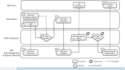
The framework of the MSP data process as applied in Ireland, is shown in . It is illustrated using the industry standard Business Process Model and Notation (Soley Citation2011), and provides a powerful tool to facilitate data integration. Having a clear view to the steps, transitions and dependencies contained within the process allows existing integration points to be identified and exploited, or future integration planned as part of a common, transparent process.
Figure 2. The Marine Spatial Planning data process as applied in Ireland, represented using the Business Process Model and Notation.
Shucksmith and Kelly (Citation2014) developed a process for data collection and evaluation within MSP, some of which overlaps with the data management framework presented in this paper. Therefore, it provides a useful model to understanding how the technical activity of the data management process supports the broader MSP process. Their framework begins with the definition of the relevant planning area; moves to identification of important biophysical features; examining data sources and identifying data gaps; consultation with key stakeholders; formal public consultation; steering group facilitation of the implementation of the plan; and review and evaluation.
Similar work at the University of Turku (Nylen et al. Citation2019) where a step-by-step approach has been developed to foster cross-border collaboration on spatial data in MSP, was applied to the framework proposed in an Irish context; correlations are called out throughout the process. Nylen et al.’s steps cover: identification of the plan area; identifying thematic content for analyses; identifying necessary data; evaluating data and accepting spatial data principles; collecting existing data; harmonising spatial data; producing spatial data; managing spatial data; planning spatial analyses; analysing spatial data and interactions; transforming spatial analysis into meaningful results for MSP; visualising spatial information; reporting spatial data and analysis; and storing and distributing spatial data.
The MSP data process, as implemented in Ireland, includes 10 interconnected components. Each component is summarised in and further explained below.
Data Management Quality Management Framework (QMF)
Table 3. Marine spatial planning data process checklist.
The overall aim of the Data Management Quality Management Framework (QMF), developed at the Marine Institute in Ireland (Leadbetter et al. Citation2019), is to encourage and support continual improvement of the quality of the delivered data, products and services by assuring the quality of the processes and procedures used in the generation of data or data products.
Data standards support the harmonisation of marine data which is a key stepping stone to the goals of developing marine spatial planning capabilities and improving knowledge of the marine environment which can facilitate better levels of protection of marine areas. The Irish Marine Institute’s internal Data Strategy has a focal area on ‘Connectivity’, which is aimed at harmonising Marine Institute data and inputting them to various networks. This harmonisation and input is achieved by applying appropriate data governance and standards to produce a consistent data architecture and data storage system to provide integration and reuse in the context of MSP.
Benefits of having a quality management framework in place include: greater consistency in data, products and services, increased efficiency by improving time and resources, improved customer satisfaction, consistency with all processes across the service areas, continuous assessment and improvement.
A Data Management Quality Management Framework (DM QMF) for Marine Spatial Planning (MSP) assists in defining how prioritised datasets, relevant to MSP, are managed; as well as supporting consistent data storage, retention, disposal and access controls. Through regular performance reviews, each process can be challenged around its relevance to the delivery of optimised products and services, beyond the initial process requirements. This moves towards delivering the highest standards of evidence used for planning and decision making.
Whilst organisations like the Marine Institute can certainly lead by example in having an established and well managed quality management framework, third party organisations providing data for MSP may not know, or have such data management practices in place. This is important information to capture as it will feed into any assessment of a dataset against a data maturity matrix at a later point in the MSP data process (see ‘7. Marine Spatial Planning Data Stewardship Maturity Matrix’ below).
Marine Spatial Planning Data Governance
This refers to the governance of the datasets managed by the MSP data process and not to the governance of the MSP data process. The MSP data process must acknowledge data ownership, intellectual property rights and copyright (Shucksmith and Kelly Citation2014). This is the realm of Data Governance, which is ‘the exercise of authority, control and shared decision making (planning monitoring and enforcement) over the management of data assets’ (DAMA Citation2009). MSP Data Governance ensures that there are procedures defining how data should be handled and re-used for MSP services. It identifies who may access the various classifications of data () and for what purpose. It provides guidelines relating to data access; data classification, data licensing, data protection; roles and responsibilities and guidance on dataset storage, retention and backup.
MSP Data Governance should build on existing policies. An example is the Irish Marine Institute’s Data Policy (Marine Institute Citation2017) which clearly states the requirements for responsible and appropriate use of the Institute’s data and information resources. These data policies should take relevant legislation into consideration. Within the European context, this may include Access to Information on the Environment; Freedom of Information; INSPIRE Spatial Data Infrastructure; and the General Data Protection Regulation.
MSP Data Governance acts as a key input to the reuse and integration guidelines adhered to in this MSP data process. By knowing how data should be handled and reused, it can be used to inform the data infrastructure prototyped below.
Marine Spatial Planning Data Standards for Integration & Reuse
This MSP data process was developed with the FAIR principles of data management in mind: Findable, Accessible, Interoperable, Reusable (Wilkinson et al. Citation2016) and introduces a number of common approaches and standards for consideration when planning how data and metadata are made available. The complete list of guidelines are presented in .
Data Suitability for Marine Spatial Planning
Table 4. MSP standards and reuse checklist.
‘Data Suitability for Marine Spatial Planning’ is a formal and considered assessment of the appropriateness of a dataset for use in Marine Spatial Planning. It is described as an ‘initial dialogue’ between the Data Owner and the MSP Decision Maker. It is subjective and can only be decided using well defined ‘business logic’ and/or expert knowledge around what datasets are considered most relevant to marine spatial planning; examples include datasets of national importance around ecosystem services and climate change.
Evidence-based planning is dependent on the availability of data and knowledge in relation to the marine environment, human activities, socio-economic factors or pressures. Evidence gathering is an important component of the marine spatial planning process and helps to inform marine planning decisions through an on-going data discovery exercise using national and international data sources. The data discovery process involves formal and informal interactions including: workshops, conference events, meetings and teleconferences providing a platform for discussing available data with data managers and data owners.
In the MSP data process, an MSP Data Catalogue (see ‘6. Marine Spatial Planning Data Catalogue’) is recommended to store the output of the ‘Suitability assessment’ (‘MSP Suitable’ or ‘Not MSP Suitable’) along with all other required metadata and provenance information.
This step correlates to Step 3 ‘Identify Necessary Data’ as presented in the University of Turku Guide for Cross-Border Spatial Data Analysis in Maritime Spatial Planning (Nylen et al. Citation2019).
Marine Spatial Planning Data Provenance
An MSP Data Provenance document provides a complete checklist of metadata that needs to be captured for all data deemed suitable or potentially suitable for Marine Spatial Planning. Each metadata entry must be clearly described and mandatory items provided.
This set of recommended metadata entries is informed by MSP Data Governance and in turn defines the information that is needed for each candidate MSP suitable dataset. These metadata entries have been considered when presenting and recommending data standards for reuse and integration. Recommended provenance information is described in .
MSP Data Catalogue
Table 5. Recommended data provenance information.
The MSP Data Process supports two broad categories of data assets when describing data as part of a central data catalogue. The first of these categories refers to data that is deemed both ‘suitable’ and ‘ready’ for MSP and can be provided to the general public. The second category refers to data that may be described in the data catalogue but may not be available to the public, e.g. due to its licensing or classification. In the latter case, restrictions should be enforced by the data catalogue to ensure only appropriate users can access restricted metadata. In terms of applying restrictions to the actual data product or dataset, the MSP Data Catalogue acts as the central register to support data access decisions and provisioning, e.g. datasets may be published externally if clearly classified as ‘Open’ and licensed as ‘CC-BY’ (‘Creative Commons’ Citation2013).
As a consequence, two distinct catalogues are presented:
(6.1) Internal MSP Data Catalogue
An internal Content Management System is designed to store and manage data asset descriptions for all data regardless of classification. This system can be used to store information relating to candidate MSP datasets, allowing their suitability/readiness to be assessed and improved over time. It is proposed that an MSP suitability field be applied to any catalogue entries that have been assessed and deemed suitable for MSP. The internal data catalogue should act as a central point of truth for all data assets and be populated with accurate and up-to-date MSP Provenance information.
(6.2) External MSP Data Catalogue
An external data catalogue providing an external and public facing view to published data descriptions (sub-set of the internal system). This facilitates the discovery and download (where applicable) of open data products.
This correlates to Step 5.1 (Nylen et al. Citation2019) in Establish Metadata Catalogue for MSP data.
MSP Data Stewardship Maturity Matrix
One approach to the assessment of the soundness, utility documentation, transparency, preservation, how easily it may be integrated with other data, obtainability and usability of a dataset is the application of a maturity model to the dataset in question (Peng Citation2018). Certain criteria from the Data Stewardship Maturity Models have been refined to provide an assessment of a dataset’s readiness for use in Marine Spatial Planning. As an objective assessment, automated processes can be used to calculate the score of a given dataset from a well-defined maturity matrix.
A score can be derived from a series of data management components. Peng (Citation2018) provides an objective assessment model for measuring how well data are managed in terms of: discoverability; accessibility; usability; preservation; and curation. Using these measurements, datasets and data management processes can be compared objectively and improved over time.
This approach was adapted the ‘WGISS Data Management & Stewardship Maturity Matrix’ which is a ‘systematic assessment model for measuring the status of individual datasets’ (CEOS.WGISS.DSIG.DSMM Citation2017).
For each of the components of the Maturity Matrix a four-level maturity scale is applied:
Level 0: Not Managed
Level 1: Limited Management
Level 2: Managed
Level 3: Well Managed
For example, under one of the accessibility criteria a dataset which is distributed as a CSV file would be at Level 1, whereas a dataset with a Web Map Service including a preview and which may be processed with hosted services would be at Level 3. Similarly under one of the preservation criteria, a dataset with no verification or validation of its metadata would be at Level 0 whereas a dataset which has had its metadata reviewed by a data management professional alongside a domain expert and been validated against a tool, such as the INSPIRE metadata validator, would be at Level 3.
The resulting score, from the levels, may then be used to help determine the readiness for MSP of a particular dataset. The dataset will only be released publically upon passing a threshold value, with complete transparency offered to the end users as to how the rating was determined. This scoring therefore deems whether a dataset is then viewable in an MSP portal as a map layer or not.
This scoring procedure correlates to Step 11.1 (Nylen et al. Citation2019) in Transform Spatial Analysis Outputs into Meaningful Results for MSP.
Data Readiness for MSP
‘Data Readiness for MSP’ is a formal and objective assessment of the ease with which a dataset may be integrated for use within Marine Spatial Planning. It lends itself to being developed as an automated process informed by the rating determined by the Data Stewardship Maturity Matrix.
Data Readiness for MSP relates to the FAIR Principles (Wilkinson et al. Citation2016); Findable – are the metadata around the data present and of a standard? Accessible – where is the data stored and in what format? Interoperable – is the metadata standardised formal, accessible, shared and in an applicable language to describe the data? Finally, Reusable – are there clear usage licences in place to provide accurate information on provenance?
Data Readiness for MSP takes into consideration the file formats being presented for both storage and for serving to end users; and can recommend a list of work required to prepare the data for it to be externally accessible through the MSP portal. For example, if data are provided in a tabular format, some processing is required in order to develop the appropriate GIS spatial layers. This would result in a lower rated dataset than if it were submitted as a final map layer.
Data Readiness for MSP can then be used as the main trigger for the data being displayed through an external MSP Portal. There are several reasons a dataset might not be ‘MSP ready’, but may well be at a future date. Factors such as time-bound embargos on research data, data collection or processing is still ongoing, or existing data licensing restrictions can all affect MSP data readiness.
This correlates to Step 4 ‘Evaluate Data and Accept Spatial Analysis Principles’ (Nylen et al. Citation2019).
At a high level, both Data Suitability for MSP and MSP Data Readiness for MSP assessments should consider the following:
Adherence to a number of best practice guidelines in the area of data management, data integration, data standards and reuse
Provision of a minimum set of data provenance information and metadata
Data Readiness for MSP is considered later in the process as it is only through the application of data management best practices to a dataset that its full readiness may be assessed, while the suitability for MSP may be known from user requirements prior to the acquisition of a dataset.
Marine Spatial Planning Data Storage and Management System
The MSP Data Storage and Management system provides for a reliable storage system with managed access to MSP data, as described in the MSP Data Catalogue. A scalable and reliable database is central to this component and more specifically a spatial database is the preferred method for managing MSP data (Stamoulis and Delevaux Citation2015). In addition, data should be served, where possible via a geospatial server using open standard formats.
From an MSP data process perspective, an important dependency exists between the MSP Data Catalogue and the MSP Data Storage and Management system; only data that has been accurately described in the data catalogue and deemed ‘MSP Ready’ should be included in the storage system and published via a geospatial sharing server. It is also important to ensure that data access is managed based on the classifications and licensing recorded for MSP data assets, e.g. robust and auditable security and access controls should be in place when storing any commercially sensitive data. In contrast, ‘Open’ data should be made available using open formats to encourage reuse.
Finally, it is important to ensure that a workflow is in place to synchronise the data descriptions held in the MSP Data Catalogue and the MSP Storage and Management system. In the event that data classifications, licensing or available parameters are updated, these changes should be reflected where data is stored and/or published.
This correlates to Step 6.4 Harmonise Data Types and 6.5 Harmonise Coordinate reference System and File Format (Nylen et al. Citation2019)
MSP Data Portals
The MSP data process described above ensures that data suitable for MSP can be assessed, described, stored and published using open standards and formats. The framework also provides traceability in terms of data lineage, data classification and licensing, ensuring that data and metadata are securely stored and shared with appropriate users.
Open data portals are defined as ‘web-based interfaces designed to make it easier to find re-usable information’ (European Commission Citation2018). Such portals can be considered as final outputs of the Marine Spatial Planning framework and allow end users and interested parties to view and interact with MSP suitable data. The framework does not prescribe how end-user applications, portals and decision support systems should be implemented, instead it provides a central ‘source of truth’ allowing data assets to be presented and reused to meet the needs of the many users of MSP.
For example, marine planners may require a decision support system using MSP data to inform planning applications or help define future polices, this information may not be available in the public domain. In contrast, members of the public or residents immediately impacted by planning decisions may require access to an open, online portal providing visibility and transparency to planning decisions. Implementers are free to develop data portals, map viewers and applications to respond to the needs and requirements of their users.
This correlates to Step 12 Visualise Spatial Information (Nylen et al. Citation2019).
3. Results
3.1. MSP data process prototype implementation
While developing the Marine Spatial Planning data process, a prototype was developed and deployed as an initial proof of concept. This approach allowed the core components of the framework to be piloted using sample data against a set of prioritised user stories, capturing the needs of MSP users. User stories informed a suite of test cases used to objectively asses the quality of the prototype and underlying framework ().
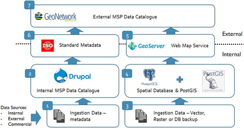
Figure 3. MSP Framework – Reference Deployment (Leadbetter et al. Citation2020).
Feedback and learnings from both designing and piloting the prototype solution have been incorporated into the overall MSP data process and inform many of the recommendations and guidelines included in this paper, a high level summary of the prototype is described below.
Note the following:
Technology and software approaches used in the prototype represent one way to operationalise a framework for MSP, other architectures and/or technology choices may be more appropriate for your organisation.
An external MSP Data Catalogue is included in the prototype architecture. This represents one, sample view of how data and metadata can be published and discovered externally, however, many other data portals, map viewers and decision support systems could be implemented, making use of the same underlying data interfaces.
This prototype assumes an ‘Open’ classification for all published data and metadata. For this reason, open, read-only access is provided to data and metadata published via the External MSP Data Catalogue.
Ingestion Data (metadata): Ingestion data may originate from internal, external or commercial (restricted access) sources. As already discussed, the MSP Data Provenance template provides an agreed set of metadata fields which should be captured for all data deemed suitable or of potential relevance for Marine Spatial Planning, regardless of its origin. Before data can be considered for ingestion, accurate provenance information should be supplied, reviewed and uploaded to the Internal MSP Data Catalogue.
Internal MSP Data Catalogue: This is an internal repository of data descriptions and metadata, developed using the Drupal (https://www.drupal.org/) content management framework. Drupal is an open-source, community based framework enabling rapid development of web applications and is particularly suited to content management systems such as the MSP Data Catalogue. This repository is designed as an internal intranet portal only and cannot be accessed outside a system firewall. Note: The prototype implementation supports publishing of appropriate metadata (subset) to an external facing catalogue as required.
The Internal MSP Data Catalogue is designed to store and manage data asset descriptions for all data regardless of classification. This system can be used to store information relating to candidate MSP datasets, allowing their suitability to be assessed and improved over time. An Internal Data Catalogue should also store information on the suitability and also the readiness of a data asset, this can serve as a useful ‘gate’ when determining if data should be published.
Ingestion Data – Vector, Raster or DB Backup: This represents the actual data that has been described in the Internal MSP Data Catalogue and will be stored within the spatial database component described in the next component. The prototype system addresses two ingestion mechanisms:
Where a dataset file/archive is provided, spatial data should be included through open formats such as Shapefile (Dempsey Citation2015) or GeoJSON (https://geojson.org) with appropriate accompanying metadata. If this format cannot be provided, the data should be supplied through an open file format with relevant spatial coordinates supplied within the dataset.
In some cases, data may be supplied as a complete database backup file. In this case, data will be restored and processed in a staging system before being consolidated into the main storage system.
Spatial Database: This represents a prototype core data storage and management system and consists of the following:
PostgreSQL Database(s): PostgreSQL (https://www.postgresql.org/about/) is a powerful, open source object-relational database system with a strong reputation for reliability, feature content and performance.
PostGIS: PostGIS (https://postgis.net/) is an additional open source add-on to the core PostgreSQL database component. It adds a range of additional data types (e.g. geometry, geography, raster), allowing data to stored and queried spatially.
GeoServer Web Map Service: GeoServer is an open source, java based sever, allowing geospatial data to be published using open standards in line with the FAIR Principles. The GeoServer component can be configured to connect directly with PostgreSQL database instances, allowing data to be served using a range of OGC compliant standards such as Web Feature Service (WFS), Web Map Service (WMS), and Web Coverage Service (WCS).
Standard Metadata: The internal Data Catalogue has been developed to export metadata for INSPIRE datasets and services in ISO/TS 19139 (INSPIRE ISO 19139 Standard Citation2007) based XML format in compliance with the INSPIRE implementing rules for metadata. This allows dataset descriptions and associated information to be published from the MSP Data Catalogue using industry standard formats and metadata rules.
External Data Catalogue (GeoNetwork): GeoNetwork (https://geonetwork-opensource.org/) is an open source catalogue application to manage spatially referenced resources. It provides powerful metadata editing and search functions as well as an interactive web map viewer. A custom implementation of GeoNetwork has been prototyped to serve as the external/public facing web portal for the MSP Data Catalogue. It is important to highlight that only a subset of the content maintained within the internal Data Catalogue (Drupal) will be shared externally. It is proposed that only descriptions classified as ‘Open’ should be published, however, rules can be customised to suit business requirements.
The external data catalogue includes an automated and configurable harvest capability. This allows the previously exported data descriptions to be imported and published on the Irish public facing portal.
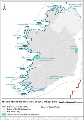
Figure 4. Sample Map from the NMPF Report page 77.
4. Lessons learned
This paper describes a data management process used to help deliver Marine Spatial Planning in Ireland. The definition of this process has been iterative in nature and has taken into consideration feedback from interested parties and learnings gained from developing and piloting an end-to-end proof of concept deployment. Therefore, the following general recommendations are made:
The owner of any candidate MSP datasets should liaise with both a nominated, centralised Data Management team and MSP Practitioners (decision makers) to ensure data has been appropriately described, prepared and made available according to MSP Reuse Standards for data Integration & Reuse [Step 1 – Data Management QMF].
Each data provider should have their own internal Data Management quality management processes in place [Step 1 – Data Management QMF].
Internal data governance polices and processes of data producers, data repositories and data publishers must be aligned with the needs of MSP. It is important that MSP is not delivered in isolation from other data services within an organisation. Many of the topics discussed in the paper represent good data management practice and should complement existing projects or be reused for new projects [Step 2 – MSP Data Governance].
All personal sensitive information must be treated in accordance with the legislation; pointing towards owners of the data individual Privacy Statement, Data Protection Policy, Breach Policy, Data Retention Policy and Data Access Request Procedures [Step 2 – MSP Data Governance].
Data Integration & Reuse Guidelines must be considered, defined, applied and adhered to [Step 3 – MSP Data Integration & Reuse].
Each data submission handled by the process must be accompanied with accurate and current MSP Data Provence information [Step 5 – MSP Data Provenance].
Each data submission handled by the process must have an appropriate data licence applied to it – preferably CC BY 4.0 or another open data licence [Step 6 MSP Data Catalogue].
All metadata accompanying data submissions should be recorded in an internal MSP Data Catalogue where appropriate data governance policies can be applied [Step 6 MSP Data Catalogue].
Technologies and architectures chosen to store, describe and disseminate data should use open data standards and support open data formats [Step 6 MSP Data Catalogue, Step 9 MSP Data Storage & Management System and Step 10 MSP Data Portals].
Standard vocabularies and taxonomies should be used where possible when describing data, e.g. recording datasets parameter lists in the MSP Data Catalogue, (Leadbetter, Lowry, and Clements Citation2014) [Step 6 MSP Data Catalogue].
All end-user experiences and customer feedback, both positive and negative are important. User engagement should be supported where possible by developing; intuitive user guides, tutorials and feedback options to allow the process to be enhanced [General].
5. Conclusions
The draft National Marine Planning Framework for Ireland was launched in November 2019 and public consultation on the draft was open until the end of April 2020. The draft included twenty-four maps generated using data managed through the framework described above and the public consultation allowed for feedback to be gathered on the framework by proxy. Whilst at the time of writing the responses related to the mapping products have not all been fully analysed, the indications are that no specific issues with the data have been identified. However, one clear area that effort must be put into is the full data discovery exercise which needs strong and clear coordination in order to ensure the full suite of available Marine Spatial Planning relevant datasets can be included within such map products.
Our findings from the pilot show metadata records containing information about the dataset, including how it can be accessed, will likely be the first information about the dataset that is read. This record should contain enough information about the data, collection methods, and format of the data to enable the re-user to determine whether the data are fit for purpose or not. Data lineage is an important first step for data governance; a visual representation of data lineage helps to track data from its origin to its destination. MSP users require data of high integrity, uniformity and correctness. ‘A picture paints a thousand words … ’ the ability to visually identify strengths, weaknesses, opportunities and threats within a process will greatly enhance the delivery of the highest standards of evidence used for planning and decision making for MSP.
It is recommended that data intended for reuse should have a licence – a legal document that states how the data should be attributed, and for which purposes it may and may not be used. If licensing information is ambiguous or omitted from the metadata record it makes it necessary to have to contact the data custodian for more information and/or to negotiate licence terms. Once users have been reliably authenticated and authorised to obtain or access the data, secure channels must be provided to protect non-open data.
Planning from the start; thinking about data reuse in advance and documenting it, saves time by helping plan research processes and workflows early in a project. Applying correct citation ensures the recognition of others data as well as the appropriate use of licensing can specify any rules that need to be adhered to. The use of sufficient metadata describing how the data has been collected, analysed and transformed along with the use of standard vocabularies in the metadata also enhances the reuse potential of a given dataset. The most effective way to have data reused is to publish it (Australian National Data Service Citation2015). There are numerous channels in which to discover data for reuse: data repositories, research publications, supporting documentation, general web searches and colleague interactions to mention but a few.
Following the ten key components of the MSP Framework referenced in has helped to create an environment capable of supporting blue economic growth by delivering a data management framework in support of a marine spatial plan for Ireland in a sustainable and transparent manner.
Acknowledgement
This work is part supported by the Irish Government and the European Maritime & Fisheries Fund as part of the EMFF Operational Programme for 2014–2020.
Disclosure statement
No potential conflict of interest was reported by the author(s).
Additional information
Funding
References
- Ansong, J., H. Calado, and P. M. Gilliland. 2019. “A Multifaceted Approach to Building Capacity for Marine/Maritime Spatial Planning Based on European Experience.” Marine Policy. Elsevier Ltd. doi:10.1016/j.marpol.2019.01.011.
- Australian National Data Service. 2015. “Data Reuse.” Data Reuse. https://www.ands.org.au/working-with-data/publishing-and-reusing-data/data-reuse.
- CEOS.WGISS.DSIG.DSMM. 2017. “WGISS Data Management and Stewardship Maturity Matrix.” Committee on Earth Observation Satellites. http://ceos.org/document_management/Working_Groups/WGISS/Interest_Groups/Data_Stewardship/White_Papers/WGISS Data Management and Stewardship Maturity Matrix.pdf.
- “Creative Commons.”. 2013. https://creativecommons.org/licenses/by/4.0/.
- DAMA. 2009. DAMA Data Management Body of Knowledge (DMBOK): Functional Framework. https://dama.org/sites/default/files/download/DAMA-DMBOK2-Framework-V2-20140317-FINAL.pdf.
- Dempsey, Caitlin. 2015. “What Is a ShapeFile?” GIS Lounge. https://www.gislounge.com/what-is-a-shapefile/.
- DHPLG. 2017. Towards a Marine Spatial Plan for Ireland. Dublin, Ireland. https://www.housing.gov.ie/sites/default/files/publications/files/towards_a_marine_spatial_plan_for_ireland.pdf.
- DHPLG. 2018. National Marine Planning Framework Baseline Report. Dublin, Ireland. https://www.housing.gov.ie/sites/default/files/publications/files/national_marine_planning_framework_baseline_report.pdf.
- DOI. 2000. “The DOI System.” http://www.doi.org/.
- Ehler, Charles, Jacek Zaucha, and Kira Gee. 2019. “Maritime/Marine Spatial Planning at the Interface of Research and Practice.” In Maritime Spatial Planning, edited by Cham Palgrave Macmillan, 1–21. Cham: Springer International Publishing. doi:10.1007/978-3-319-98696-8_1.
- European Commission. 2014. Directive 2014/89/EU - Maritime Spatial Planning. http://eur-lex.europa.eu/legal-content/EN/TXT/?uri=uriserv:OJ.L_.2014.257.01.0135.01.ENG.
- European Commission. 2018. Open Data Portals. https://ec.europa.eu/digital-single-market/en/open-data-portals.
- Gissi, Elena, and Juan Luis Suarez de Vivero. 2016. “Exploring Marine Spatial Planning Education: Challenges in Structuring Transdisciplinarity.” Marine Policy 74: 43–57. doi:10.1016/j.marpol.2016.09.016.
- INSPIRE ISO 19139 Standard. 2007. https://inspire.ec.europa.eu/id/document/tg/metadata-iso19139.
- Inter-Departmental Marine Coordination Group. 2012. Harnessing Our Ocean Wealth: An Integrated Marine Plan for Ireland. http://www.ouroceanwealth.ie/SiteCollectionDocuments/Harnessing Our Ocean Wealth Report.pdf; http://hdl.handle.net/10793/810.
- “ISO 19115 Standard.”. 2014. https://www.iso.org/standard/53798.html.
- Kelly, Christina, Geraint Ellis, and Wesley Flannery. 2019. “Unravelling Persistent Problems to Transformative Marine Governance.” Frontiers in Marine Science. doi:10.3389/fmars.2019.00213.
- Kull, M., J. R. Moodie, H. L. Thomas, S. Mendez-Roldan, A. Giacometti, A. Morf, and I. Isaksson. 2019. “International Good Practices for Facilitating Transboundary Collaboration in Marine Spatial Planning.” Marine Policy (April). doi:10.1016/j.marpol.2019.03.005.
- Leadbetter, Adam, Ramona Carr, Sarah Flynn, Will Meaney, Siobhan Moran, Yvonne Bogan, Laura Brophy, Kieran Lyons, David Stokes, and Rob Thomas. 2019. “Implementation of a Data Management Quality Management Framework at the Marine Institute, Ireland.” Earth Science Informatics (December) 13: 509–521. doi:10.1007/s12145-019-00432-w.
- Leadbetter, Adam M., Roy K. Lowry, and D. O. Clements. 2014. “Putting Meaning into NETMAR - the Open Service Network for Marine Environmental Data.” International Journal of Digital Earth 7: 811–828. doi:10.1080/17538947.2013.781243.
- Leadbetter, Adam, Will Meaney, Elizabeth Tray, Andrew Conway, Sarah Flynn, Tara Keena, Caoimhín Kelly, and Rob Thomas. 2020. “A Modular Approach to Cataloguing Marine Science Data.” Earth Science Informatics 13 (2): 537–553. doi:10.1007/s12145-020-00445-w.
- Leadbetter, Adam M., and Peter N. Vodden. 2016. “Semantic Linking of Complex Properties, Monitoring Processes and Facilities in Web-Based Representations of the Environment.” International Journal of Digital Earth 9: 300–324 doi:10.1080/17538947.2015.1033483.
- Marine Institute. 2017. Marine Instititue Data Policy. Galway, Ireland. https://www.marine.ie/Home/sites/default/files/MIFiles/Docs/DataServices/Marine Institute Data Policy 2017.pdf.
- Marine Institute. 2018. EMFF Operational Programme: Project 5: Integrating Marine Spatial Data: Best Practice in Modelling and Decision Support Tools. https://emff.marine.ie/blue-growth/project-5-integrating-marine-spatial-data-best-practice-modelling-and-decision-support.
- Norton, C., J. Barnes, D. O’Broin, W. Flannery, C. Adamson, and S. Berne. 2014. Recommendations for Preparing Maritime Spatial Plans in Ireland. Recommendations for Preparing Maritime Spatial Plans in Ireland.
- Nylen, T., H. Tolvanen, A. Erkkila-Valimaki, and M. Roose. 2019. Guide for Cross-Border Spatial Data Analysis in Marine Spatial Planning. ISBN 978-951-29-7636-2.
- Peng, Ge. 2018. “The State of Assessing Data Stewardship Maturity – An Overview.” Data Science Journal. doi:10.5334/dsj-2018-007.
- Schaap, Dick M A, and Roy K. Lowry. 2010. “SeaDataNet - Pan-European Infrastructure for Marine and Ocean Data Management: Unified Access to Distributed Data Sets.” International Journal of Digital Earth 3: 50–69. doi:10.1080/17538941003660974.
- SEMRU. 2017. Irelands Ocean Economy. Galway, Ireland. http://www.nuigalway.ie/media/researchsites/semru/files/Semru—Irelands-Ocean-Economy-2017_FINALonline.pdf.
- Shucksmith, Rachel, Lorraine Gray, Christina Kelly, and Jacqueline F. Tweddle. 2014. “Regional Marine Spatial Planning - The Data Collection and Mapping Process.” Marine Policy 50: 1–9. doi:10.1016/j.marpol.2014.05.012.
- Shucksmith, Rachel J., and Christina Kelly. 2014. “Data Collection and Mapping - Principles, Processes and Application in Marine Spatial Planning.” Marine Policy 50: 27–33. doi:10.1016/j.marpol.2014.05.006.
- Soley, Richard. 2011. Business Process Model And Notation. https://www.omg.org/spec/BPMN/2.0/.
- Stamoulis, Kostantinos A., and Jade M.S. Delevaux. 2015. “Data Requirements and Tools to Operationalize Marine Spatial Planning in the United States.” Ocean and Coastal Management 116: 214–223. doi:10.1016/j.ocecoaman.2015.07.011. doi: 10.1016/j.ocecoaman.2015.07.011
- Strain, Lisa, Abbas Rajabifard, and Ian Williamson. 2006. “Marine Administration and Spatial Data Infrastructure.” Marine Policy 30: 431–441. doi:10.1016/j.marpol.2005.03.005.
- UK Data Service. 2019. “How to Share Data.” https://www.ukdataservice.ac.uk/manage-data/plan/how-share.
- Wilkinson, Mark D., Michel Dumontier, IJsbrand Jan Aalbersberg, Gabrielle Appleton, Myles Axton, Arie Baak, Niklas Blomberg, et al. 2016. “Comment: The FAIR Guiding Principles for Scientific Data Management and Stewardship.” Scientific Data 3. doi:10.1038/sdata.2016.18.