
ABSTRACT
The Aral Sea crisis is considered one of the most severe ecological tragedies from the 1960s in Central Asia. The reasons for this crisis, especially in the twenty-first century, are still scientific disputes. This study investigated the relationship between land cover change in the Aral Sea related basins and the Aral Sea crisis from 2000 to 2020 by employing the GlobeLand30 dataset with 30 m resolution. Results showed that the cultivated land in the Aral Sea basin increased by 2,291 km2, and 75.4% of it occurred in the region of Karakum Canal, the largest water conservancy project for irrigation in the world. The water surface area of reservoirs increased by 1,183.5 km2 during the same period. Coincident with this change, the Aral Sea further shrank from 26,280.8 km2 in 2000 to 9,285.2 km2 in 2020, mainly occurred in the first decade of the twenty-first century. These imply that the Aral Sea crisis is persistent in the twenty-first century and is likely driven by water competition among different regions within the basin for agricultural irrigation. Strengthening the coordination and cooperation of cross-boundary water resource management is still the most important management strategy choice to address the crisis from a broader perspective.
1. Introduction
The Aral Sea, formerly the fourth largest lake in the world, is located at the junction of Kazakhstan and Uzbekistan in Central Asia. Its water supply is mainly from runoff from the Amu Darya and Syr Darya basins. Unfortunately, since the 1960s, a sharp decrease in the amount of water flowing into the sea has produced an unprecedented crisis in the Aral Sea (Micklin Citation1988). From 1960 to 1989, the water level dropped by 14.3 m, and the area and volume decreased by 41% and 67%, respectively, with the average salinity increasing by 300% to 30 g/litre. Since 1987, the Aral Sea has separated into a smaller part in the north (North Aral Sea) fed by the Syr Darya and a larger part in the south (South Aral Sea) fed by the Amu Darya (Micklin Citation2016). This trend continued into this century (Micklin Citation2006). In August 2005, the government of Kazakhstan completed the construction of the Dike Kokaral dam to raise and stabilize the water level in the North Aral Sea at approximately 42 m (Waltham and Sholji Citation2001). In contrast, the water level decreased from 30 m to 26 m in the South Aral Sea due to a lack of relevant policies (Micklin Citation2016). The loss of the Aral Sea has led to severe and widespread environmental and social impacts throughout the whole basin, such as salt and dust storms, biological productivity loss, deltaic ecosystem deterioration, groundwater level decrease, disruption of the regional climate balance, lack of domestic water supply, health risks, and economic losses (Micklin Citation1988; Tanton and Heaven Citation1999).
The causes of the Aral Sea crisis were controversial. Some studies indicated that climate change was one of the main factors. Khromova et al. (Citation2006) and Sorg et al. (Citation2012) argued that decreased inflows to the Aral Sea were mainly induced by decreased snow cover driven by rising temperatures. He, Zhang, and Liu (Citation2016) used the Soil and Water Assessment Tool (SWAT) model to estimate the decline in streamflow in the Amu Darya basin due to changes in precipitation. Other studies, such as Micklin (Citation1988) and Spoor (Citation1998), argued that anthropogenic activity was the most important factor leading to decreased inflow to the Aral Sea. The reduction in streamflow caused mainly by irrigation may have resulted in remarkable changes in the surface area of the Aral Sea. Irrigation has been the most important anthropogenic factor influencing this region and includes at least two aspects. The first is agricultural irrigation within the drainage basin. After the Soviet Union launched policies with the goal of achieving independence in cotton production during the 1960s, and the cotton planting area expanded rapidly; for example, the area increased 8,000 km2 in Uzbekistan during the 1960s to 1980s (Spoor Citation1998). Cotton production in the former Soviet Union increased from 4.3 million tons to 8.7 million tons from 1960 to 1988 (White Citation2013). This increased water demand for irrigation led to massive water extraction from the Amu Darya and Syr Darya basins (Saiko and Zonn Citation2000). The second is water conservancy projects related to irrigation systems initiated by the government, which include reservoirs, dams, and inter-basin water-transfer projects. In particular, the Karakum Canal, which has a length of 1,380 km in Turkmenistan, is the largest and longest irrigation canal constructed from 1953 to 1986 (Zonn Citation2012). In addition, as a drainage collector of irrigation water, Sarykamysh Lake was formed in 1971 and is located 200 km away from the southwestern Aral Sea (Kostianoy, Lebedev, and Solovyov Citation2014). All of this resulted in more water being trapped and evaporated. After the collapse of the Soviet Union in 1991, the fate of the Aral Sea became more complicated because many recovery programs were disrupted (Tanton and Heaven Citation1999). This complexity increases the importance of studying the Aral Sea crisis in this century.
Land cover change is the most direct reflection of the effects of anthropogenic activity on natural ecosystems, and it reveals the interactions between anthropogenic activities and ecological processes (Liu et al. Citation2014; Hu et al. Citation2015). Thus, the definitive assessment of changes in land cover is key to evaluating the effects of anthropogenic activity on the Aral Sea basin (Sterling, Ducharne, and Polcher Citation2013), where the ecological environment is very vulnerable and anthropogenic activities are intensive (Lioubimtseva and Henebry Citation2009). Irrigation, which would be the most important anthropogenic factor in the extent of the entire Aral Sea basin, can lead to intense water consumption by either the expansion of croplands or the creation of water bodies in the form of reservoirs, and both changes can be revealed by examining the alterations in the land cover. Therefore, analysis of land cover changes in the Amu Darya and Syr Darya basins, which are both drainage basins of the Aral Sea, and in the region of the Karakum Canal, which diverts large amounts of water from the Amu Darya basin to irrigated land, could help better understand the reasons for the Aral Sea crisis. Land cover changes in the Aral Sea basin have been investigated using coarse-resolution land cover datasets (Klein, Gessner, and Kuenzer Citation2012; Zou et al. Citation2019). For example, Chen et al. (Citation2013) used MODIS global land cover datasets with a 500 m spatial resolution and GLOBCOVER global land cover datasets with a 300 m spatial resolution to find that the areas of farmland and natural vegetation in Central Asia increased from 539,000 km2 to 701,000 km2 and from 3,303,000 km2 to 3,132,000 km2, respectively, in 2000–2009. However, these coarse-scale land cover data limited the precision of these analyses, particularly for the land cover types featured with small areas and complex structures, such as croplands and reservoirs. These studies also mainly focused on the Amu Darya basin and Syr Darya basin but ignored the Karakum Canal. The canal diverts large amounts of water from the Amu Darya basin to irrigated land. Therefore, exploring the detailed land cover change in the region of the Karakum Canal is critical to achieving a comprehensive understanding of the Aral Sea crisis.
Benefited from the substantial efforts of land cover mapping carried out in recent years (Feng and Li Citation2020), it becomes possible to analyze land cover changes at an unprecedentedly finer scale and higher accuracy (Brovelli et al. Citation2015; Ran and Li Citation2015). The land covers related to anthropogenic activities, such as croplands and reservoirs, are not only closely related to the changes in the Aral Sea but also tend to have small areas and complex structures, which can only be investigated with accurate and fine resolution land cover data. Here, the objective of this study is to analyze the distributions and changes in land cover in the Aral Sea and the surrounding areas, including the Amu Darya basin, Syr Darya basin, and the region of the Karakum Canal, to further explore the shrinkage of the Aral Sea and its correlation with anthropogenic activities. The analysis is carried out with high-resolution land cover data to offer detailed and accurate delineations of the land covers and their changes from 2000 to 2020.
2. Materials and methods
2.1. Study area
The study area includes the Amu Darya and Syr Darya river basins, which feed the Aral Sea, and the irrigated region is distributed in Turkmenistan, which uses an artificial river – the Karakum Canal – to divert water from the Amu Darya basin ().
Figure 1. Location of the Amu Darya basin, Syr Darya basin, and the region of the Karakum Canal.
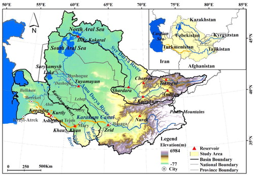
The Amu Darya River originates from the Pyanj River (Afghanistan) and the Vaksh River (Tajikistan) and flows through the Karakum Desert and empties into the Aral Sea (Agal’tseva et al. Citation2011). The total catchment area of the Amu Darya River basin is approximately 490,000 km2, with a river length of approximately 2,540 km. The Amu Darya can be divided into three reaches: the upper reach in Tajikistan; the middle reach along the borders of Afghanistan, Uzbekistan, and Turkmenistan; and the lower reach beginning at the Tuyamuyun reservoir (Schlüter et al. Citation2005).
The Syr Darya River originates from the Naryn River in Kyrgyzstan and flows through Tajikistan, Uzbekistan, and Kazakhstan. The total area of the Syr Darya River basin is approximately 565,000 km2, and the river length is approximately 3,019 km (Sorg et al. Citation2014). The Syr Darya can also be divided into three reaches: the upper reach in Kyrgyzstan and Tajikistan, the middle reach in Uzbekistan, and the lower reach in Kazakhstan (Jean-François et al. Citation2015).
The Karakum Canal was completed in 1988 to regulate water for irrigation in Turkmenistan (Zonn et al. Citation2018). In Turkmenistan, which receives limited precipitation, all cropland depends on irrigation (Thevs et al. Citation2015). The Amu Darya River flows through only Dashoguz and Lebap provinces (Thevs et al. Citation2015). The irrigation in Mary, Ahal, and Balkhan provinces mainly depends on water transferred by the canal. The Karakum Canal, which is the largest irrigation water-transfer project in the region, connects the Amu Darya, Murgab, and Tejen rivers into a single water system to maintain social and economic development (Zonn Citation2012). At present, the canal diverts 13.5 km3 of water annually from the Amu Darya basin at the Basaga settlement and flows across the Karakum Desert to Bereket (formerly Kazanjyk) (Zonn Citation2012). The southern branch of the canal extends to Kyzyl-Atrek (Zonn Citation2012). Sarykamysh Lake, which lies west of Dashoguz, receives drainage water from the surrounding irrigated regions (Orlovsky et al. Citation2014).
The climate of the Amu Darya basin, Syr Darya basin, and the region of the Karakum Canal are continental and semi-arid to arid, with cold winters, hot summers, and high potential evapotranspiration (Sorg et al. Citation2014). There is distinct variability in precipitation between summer and winter, with approximately 80% of the precipitation falling primarily in winter and early spring (Lioubimtseva, Kariyeva, and Henebry Citation2014; He, Zhang, and Liu Citation2016). In the two basins, winter precipitation, glacier runoff, and snowmelt water dominate the volume and timing of the hydrological regime (Agal’tseva et al. Citation2011). The hydrologic conditions in Turkmenistan are mainly determined by the runoff of the Amu Darya River and the Karakum Canal (Lioubimtseva, Kariyeva, and Henebry Citation2014).
Reservoirs play a key role in anthropogenic activities and are built in order to regulate the flow regime. There are two large reservoirs in the Amu Darya River basin. The upstream Nurek reservoir in Tajikistan, which began operation in 1972 and is mainly used for hydropower production (Olsson et al. Citation2008). The other is the downstream Tuyamuyun reservoir, which was completed in 1983, and approximately 98% of the outflow from the Tuyamuyun reservoir is used for irrigation (Olsson et al. Citation2008).
In the Syr Darya River basin, the flow regime is more complicated because the streamflow is regulated by five reservoirs in different states, i.e. Toktogul, Andijan, Kairakum, Charvak, and Shardara, which were constructed during 1965–1985 (Jean-François et al. Citation2015). Among the five reservoirs, the upstream Toktogul reservoir in Kyrgyzstan is the largest and has the greatest water storage capacity, and it is mainly used for hydropower generation. The midstream Kairakum reservoir in Tajikistan and the Shardara reservoir on the border of Uzbekistan and Kazakhstan are used for irrigation (Rodina and Mnatsakanian Citation2012). Between the Toktogul and Shardara reservoirs, the upstream Andijan reservoir and midstream Charvak reservoir in Uzbekistan are used for hydropower generation.
There are five reservoirs in the Karakum Canal used to regulate water for irrigation in Turkmenistan, i.e. Zeid, Khauz-khan, Kurtly (Western), Kopetdag, and Madaus (currently under construction) (Zonn et al. Citation2018). The Khauz-khan reservoir is located between the Murgab River and the Tejen River. The Kurtly and Kopetdag reservoirs are located to the northwest of Ashgabat.
2.2. GlobeLand30
We adopted GlobeLand30 (http://www.globallandcover.com) data available for 2000, 2010 (Chen et al. Citation2015), and the newly published 2020 data to analyze land cover changes in the Amu Darya basin, the Syr Darya basin, and the region of the Karakum Canal. GlobeLand30 was produced by using the pixel-object-knowledge (POK) method based on multispectral satellite images, including Landsat 5 Thematic Mapper 5 (TM5), Landsat 7 Enhanced Thematic Mapper Plus (ETM+), and Chinese Environmental and Disaster (HJ-1) satellite (Brovelli et al. Citation2015) images. All images were obtained during the local vegetation growing seasons (Chen et al. Citation2015). The spatial resolution of this data product is 30 m. The classification scheme consisted of 10 classes, namely, cultivated land, forest, grassland, shrubland, wetlands, water bodies, tundra, artificial surfaces, bare land, and permanent snow/ice () (Chen, Cao, et al. Citation2017). A knowledge-based interactive verification was carried out to check and improve the accuracy of the classification result (Chen et al. Citation2015). The reference datasets were collected by third-party researchers through interpretating high-resolution images (e.g. Google Earth) and field observations (Chen et al. Citation2015). The accuracy assessment of GlobeLand30 involved more than 150,000 samples (Chen, Liao, et al. Citation2017). Meanwhile, classification errors (commissions and omissions) in land cover and its changes were checked with a variety of ancillary data (Chen et al. Citation2015; Chen et al. Citation2017). The assessment showed that the overall accuracy of GlobeLand30 was 83.51%, and the kappa coefficient was 0.78 (Chen, Cao, et al. Citation2017). Among all the land cover types, the highest accuracy was found for water bodies with a value of 92.09%, followed by forest (89%), artificial surface (86.97%), cultivated land (83.06%), wetland (79.63%), bare land (77.33%), grassland (76.88%), permanent snow and ice (75.86%), and shrubland (72.52%) (Chen, Liao, et al. Citation2017). Compared with the other two land cover datasets, i.e. CORINE and FROM-GLC with 30 m spatial resolution, GlobeLand30 exhibited a quality similar to that of the CORINE dataset, which covers only Europe in 2000, and higher than that of the FROM-GLC dataset (Chen et al. Citation2015).
Table 1. Definition of each land cover type in GlobeLand30 (Chen, Cao, et al. Citation2017).
2.3. Precipitation and streamflow
We used the TerraClimate dataset (Abatzoglou et al. Citation2018) to analyze the changes in precipitation and streamflow to better understand the variations in climate impacts on the Aral Sea crisis. TerraClimate, which was produced by the University of Idaho’s Northwest Knowledge Network, is a monthly dataset of precipitation, temperature and contains surface water balance datasets for global terrestrial surfaces (Abatzoglou et al. Citation2018). It used climatically aided interpolation, combining high spatial resolution climatological normals from the WorldClim dataset, with coarser resolution time varying data from other sources (Abatzoglou et al. Citation2018). The spatial resolution of this data product is 1/24°, ∼4 km.
2.4. Crop structure and water productivity
We used data on crop structure and water productivity to analyze whether they were a factor in driving the consumption of large amounts of water. Data on the cropland area under irrigation, crop yield, and water productivity were obtained from the WUEMoCA (Water Use Efficiency Monitor in Central Asia) site (http://wuemoca.net/app/) (Conrad et al. Citation2017). The online tool provides free access to annual spatial–temporal agricultural geo-information from 2000 to 2018, such as crop type, cropland area, yield estimations.
3. Results
3.1. Change of land covers in the Aral Sea region
The land cover in the Amu Darya basin, Syr Darya basin, and the region of Karakum Canal from 2000 to 2020 is shown in a, 2b, and 2c, respectively. The land cover changes are presented in . The areas of natural vegetation, including forest, grassland, and shrubland, all changed insignificantly. The area of artificial surfaces increased slightly in the three areas. The area of bare land decreased slightly in the Amu Darya basin and the region of the Karakum Canal, while it increased slightly in the Syr Darya basin. It is noted that the change in areas of wetland and water bodies were more dramatic, mainly related to the Aral Sea region.
Figure 2. Land cover for 2000 (a), 2010 (b), and 2020 (c) in the Amu Darya basin, Syr Darya basin, and the region of the Karakum Canal.
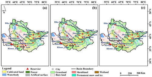
Table 2. Land cover change in the Amu Darya basin, Syr Darya basin, and the region of the Karakum Canal from 2000 to 2020 (Area: km2; Percent: %).
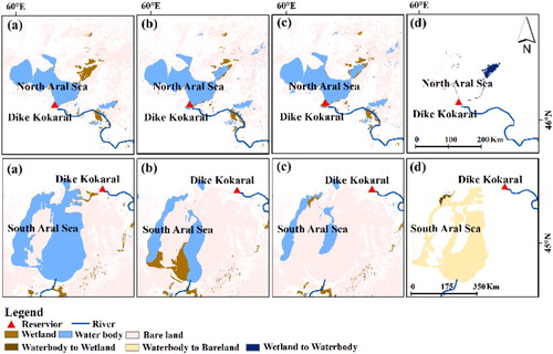
The area of water bodies in the Aral Sea shrank drastically in the last century, and the results showed that it continued to shrink this century. During the 2000s, the area of water bodies in the Aral Sea decreased by 51.6%, from 26,280.8 km2 to 12,712.3 km2. It further decreased by 27% in the 2010s and shrank to 9,285.2 km2 in 2020. In particular, water bodies exhibited different changes in the southern and northern parts of the Aral Sea region from 2000 to 2020. The area of the South Aral Sea shrank from 23,433.7 km2 in 2000 to 9,357.6 km2 in 2010, and continued to shrink to 5,889.6 km2 in 2020. However, the area of the North Aral Sea expanded slightly from 2,847.1 km2 in 2000 to 3,354.7 km2 in 2010, and continued to increase to 3,395.6 km2 in 2020. The spatial characteristics of land cover change in the Aral Sea region were mainly reflected by transitions among water bodies, wetlands, and bare lands (). From 2000 to 2010, the changes in wetlands were the opposite of those in water bodies. Approximately 13.4% of the degraded water body transitioned to wetlands in the South Aral Sea. Approximately 54.7% of the wetland area was converted to water bodies in the North Aral Sea. However, the change in wetlands showed a different trend from 2010 to 2020 compared with that during the 2000s, mainly in the South Aral Sea. With the further shrinkage of the South Aral Sea from 2010 to 2020, approximately 97.5% of wetlands, which mainly transitioned from decreased water bodies during the 2000s, were converted to bare land. The wetland area hardly changed in the North Aral Sea during the same period. In addition, from 2000 to 2020, approximately 72.3% of degraded water bodies transitioned to bare land in the South Aral Sea. Approximately 4.7% of bare land was converted to new water body, mainly distributed in the north-eastern region of the North Aral Sea during the same period.
Figure 3. Main land cover types in 2000 (a), 2010 (b), 2020 (c) and their changes (d) in the Aral Sea region from 2000 to 2020.
Changes in cultivated land and the water surface area of reservoirs, which could be related to the Aral Sea crisis, are described in detail in Sections 3.2 and 3.3, respectively.
3.2. Changes in cultivated land
In the whole study area, the area of cultivated land increased from 167,905.2 km2 in 2000 to 170,196.2 km2 in 2020, an increase of approximately 2,291 km2 or 1.4% of the total cropland area in 2000. The area of cultivated land decreased from 91,551.7 km2 to 90,046.1 km2 in the Amu Darya basin, while it increased from 55,686.7 km2 to 57,756.0 km2 in the Syr Darya basin. In the region of the Karakum Canal, the cultivated land increased from 20,666.8 km2 to 22,394.1 km2, and the relative change was 8.4%, suggesting that the irrigation area maintained an increasing trend in the newly cultivated area after the construction of the Karakum Canal.
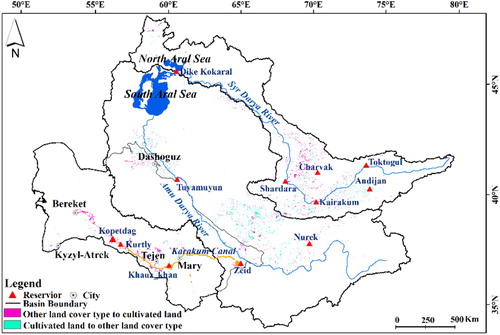
The spatial characteristics of cultivated land across the whole study area were mainly reflected by the transition among cultivated land, grassland, and bare land (). In the Amu Darya basin, although the overall cultivated land area decreased, some grassland and bare land transitioned to cultivated land distributed in western Dashoguz. In the Syr Darya basin, approximately 1.2% of grassland and 0.9% of bare land transitioned to cultivated land. Newly cultivated land was mainly located in the southern Kairakum reservoir between the Shardara and Charvak Reservoirs. In the region of the Karakum Canal, approximately 1.7% of grassland and 0.9% of bare land transitioned to cultivated land, which was mainly distributed around Mary and Tejen and along the canal. In addition, newly cultivated land that transitioned from bare land was located around Kyzyl-Atrek.
Figure 4. Spatial distribution of cultivated land changes in the Amu Darya basin, Syr Darya basin, and the region of the Karakum Canal from 2000 to 2020.
3.3. Changes in reservoirs
In total, the water areas of the reservoirs in the Amu Darya basin, Syr Darya basin, and the region of Karakum Canal increased by 1,183.5 km2 from 2000 to 2020 (, , and ).
Figure 5. The water surface areas of reservoirs and Sarykamysh Lake in the Amu Darya basin in 2000 and 2020.
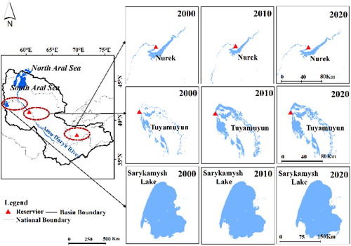
Figure 6. The water surface areas of reservoirs in the Syr Darya basin in 2000 and 2020.
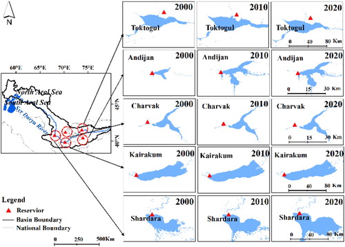
Figure 7. The water surface areas of reservoirs along the Karakum Canal in 2000 and 2020.
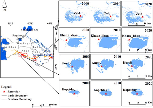
The water areas expanded significantly in the majority of reservoirs located along the Anu Darya River, Sry Darya River, and Karakum Canal between 2000 and 2020 (). Only 3 of the 12 reservoirs experienced slight decreases (≤1.4 km2) in water areas during the period. The water areas of 2 reservoirs increased by more than 338 km2, and the rest of the reservoirs and lake increased between 2.1 and 137.9 km2.
Table 3. The water surface areas of reservoirs in 2000 and 2020 and the area changes in the Amu Darya, Syr Darya basins, and Karakum Canal (Area: km2).
3.4. Impact of expansion of cropland and reservoir on the Aral Sea crisis
To discuss the impact of cropland and reservoir expansion on the Aral Sea crisis, we first analyzed precipitation and streamflow data for the upstream region and the whole basin from the beginning of the Aral Sea crisis in the 1960s to the present. As shown in , the precipitation and streamflow increased in the upstream region and increased slightly over the whole basin.
Figure 8. Trends of precipitation and streamflow in the upstream region (a) and the whole basin (b) from 1960 to 2018. (P-value < 0.05 indicates that the trends are significant at the 95% confidence level).
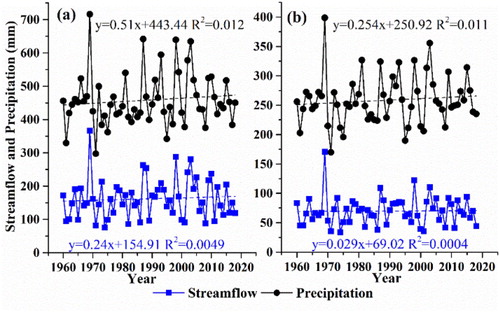
Furthermore, from 2000 to 2018, precipitation and streamflow increased slightly over the whole basin. At the same time, precipitation and streamflow also increased in the upstream region, while the further shrinkage of the Aral Sea suggested a decrease in inflows into the Aral Sea. This indicates that hydrological changes are unlikely to be the driver of the decreased inflow into the Aral Sea.
Our results revealed an increase of approximately 2,291 km2 of cropland throughout the whole study area in 2000–2020 and suggested that this would still be the major reason leading to the shrinkage of the Aral Sea. Furthermore, more seepage loss in the process of increased water demand for irrigation likely exacerbated the degradation of the Aral Sea. Under the streamflow and precipitation increased in the upstream region and precipitation changed slightly over the whole basin, new cropland was mainly distributed in the midstream and downstream regions, suggesting that increased streamflow in the upstream region was used for irrigation, thereby reducing the streamflow reaching the Aral Sea. With the increase in the area of water bodies and the expansion of cropland distributed between Mary and the end of the canal, it indicated more water withdrawn for irrigation from the Amu Darya basin and transferred by the canal. This likely further reduced inflows to the Aral Sea. Moreover, the irrigation process is accompanied by large amounts of seepage and evaporation. For example, the water loss was approximately 5–7 km3 annually during the process of transferring approximately 13 km3 of water by the Karakum Canal (Zonn Citation2012). More than half of the water loss suggested that the area of the water body, which was approximately twice as much as that of the expanded cultivated land, could meet the irrigation requirements. Therefore, the increased use of water for irrigation enhanced by water loss would induce the reduction in inflows to the Aral Sea.
In addition, the water surface area of reservoirs for both irrigation and hydropower increased by 1,183.5 km2. This could be another reason leading to decreased inflows to the Aral Sea. After the collapse of the Soviet Union in 1991, these rivers became trans-boundary rivers, and the goals of the reservoirs in individual countries were contradictory. The upstream reservoirs in Kyrgyzstan and Tajikistan are operated primarily for hydropower generation, while the reservoirs in downstream countries, i.e. Kazakhstan, Uzbekistan, and Turkmenistan, need to store water for irrigation. The reservoirs for irrigation need to store water in winter for use in summer, whereas the opposite is true for hydropower generation (Normatov Citation2004). Thus, water resource conflicts between upstream and downstream states have become more acute. From 2000 to 2020, in the case of increased upstream streamflow in the Amu Darya basin, the area of the upstream Nurek reservoir increased, suggesting that more water was stored for hydropower. This led to decreased streamflow in the downstream region. Meanwhile, the area of the downstream Tuyamuyun reservoir increased, suggesting that more water was stored for irrigation. This aggravated the reduction in inflows to the Aral Sea. Furthermore, with the increased area of cropland around Dashoguz, the increased area of Sarykamysh Lake indicated increased drainage diverted from the Amu Darya basin. The increased water surface area of the Zeid head reservoir and the other three reservoirs for irrigation in the Karakum Canal indicated that more water was extracted from the Amu Darya basin. This extraction contributed to decreased inflow to the Aral Sea. A similar situation was observed in the Syr Darya basin. Under the case of slightly increased upstream streamflow, the increased area of reservoirs for hydropower and irrigation, such as the Toktogul and Shardara reservoirs, resulted in decreased inflow to downstream regions. If actions related to water resource management were not taken by the states, the prospect of the Aral Sea would not be promising.
Furthermore, compared with the change in the Aral Sea from 2010 to 2020, the shrinkage of the Aral Sea was more drastic in the first decade of the twenty-first century. Meanwhile, the extent of expansion of cropland and reservoirs in the first decade was much greater than that in the second decade. This corresponding change trend would further suggest that the expansion of cropland and reservoirs acts as a key role in the continuous shrinkage of the Aral Sea in this century.
At the same time, the crop structure would be the factor in driving the consumption of larger amounts of water. Cotton consumes twice the amount of water as wheat (Waltham and Sholji Citation2001). Data on water productivity (unit: kg/m3), which represents agricultural production (kg) by consuming per cubic meter of water (m3), were obtained from WUEMoCA. For example, in Uzbekistan, the water productivity values of cotton and wheat were 6.8 and 12.7 kg/m3 in 2000 and 6.5 and 12.0 kg/m3 in 2015, respectively. Thus, replacing highly water-consuming cotton with less water-intensive crops would be one way to relieve the Aral Sea crisis. Furthermore, limited crop yields could be due to decreased water in the growth period induced by water conflicts and land degradation (O’Hara Citation1997) triggered by water loss. Improvements in crop production were achieved by using more water for irrigation with greater seepage loss, resulting in less inflows to the Aral Sea. Hence, the region is trapped in a vicious cycle. The crop yield data (unit: 105 kg/km2) and the areal percentage of irrigated cropland (Uir) in net irrigated land (areas equipped with irrigation infrastructure, including fallow lands) were obtained from WUEMoCA. For example, for the largest proportion of irrigated land in the region of the Karakum Canal, Uir increased from 62.3% to 101.7% in Mary Province, while the cotton and wheat yields (unit: 105 kg/km2) decreased from 1.62 to 1.49 and from 3.27 to 2.55, respectively. This indicates that mitigation of water conflicts and the reduction of water loss could be achieved by strengthening the water resource management, which is detailed in Section 4.
4. Suggestions for water resource management
The major existing policies for water resource management after the collapse of the Soviet Union in 1991 are shown in . The critical stages include the agreements in 1992 and 1998. The agreement in 1992 was the first agreement to include a trans-boundary water resource sharing scheme among the five states and established the Interstate Coordinating Water Management Commission (ICWC) following the independence of the five countries in 1991. The current treaty on water resources is based on a regime regulated in this agreement, and the ICWC acts as the policymaker. After the agreement on the Syr Darya water resource in 1998, there were no new multilateral agreements signed or under development (Mukhammadiev Citation2014). Since 2000, the only program to be enacted by the five states was the Aral Sea Basin Assistance Program (ASBP) phase 2 in 2002 (Mukhammadiev Citation2014).
Figure 9. Chronology of the main events in water resource management in the Aral Sea basin.
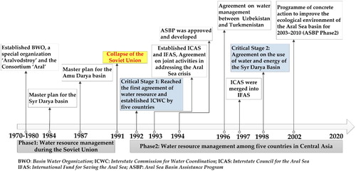
However, as shown in our results, the water surface area of reservoirs operated for both irrigation and hydropower increased, suggesting that water resource conflicts have not eased and instead become even more acute. This indicated that the existing agreements were poorly implemented due to differences in geopolitics and economy among the five states (Mukhammadiev Citation2014). Agriculture remains a major concern for governments, as evidenced by the continuous expansion of croplands and increased water demand for irrigation since 2000. Thus, water resources have not only predominantly restricted social and economic development but have also influenced the balance of relations among the five states.
From the perspective of sustainable development in the Aral Sea region, the future direction of water resource management should take into account the water use balance among agriculture, ecosystems, and the environment, as well as reasonable water resource utilization schemes for upstream and downstream areas. Reliable multi-source data within the basin are key to managing and monitoring water resources. Thus, we suggest that there is a need to form a water resource monitoring information system. Furthermore, there is a need to design an optimized decision support system to implement water resource management. Combined with the information obtained from both systems, we suggest that it is necessary to form a platform for strengthening collaboration and communication based on fulfilling individual obligations in existing agreements. It should involve a great variety of stakeholders from individual states within the basin. Stakeholders should compile and share summaries from each negotiation in the platform. This would not only widen stakeholders’ horizons but also facilitate other organizations and scientists to better understand the conditions of the Aral Sea in order to offer more suggestions. Meanwhile, stakeholders could learn from some successful cases of benefits-sharing mechanisms in other regions around the world (Jalilov et al. Citation2016). For example, the cost of Canadian dams on the Columbia River was shared by Canada and the United States (Hensengerth, Dombrowsky, and Scheumann Citation2012). The dams would not only meet the flood control requirements of the USA but also provide electricity to Canada. Thus, developing a platform for regional cooperation provides an opportunity for better managing water resources and reducing environmental risk throughout the whole Aral Sea basin.
5. Conclusion and prospect
This study adopted the GlobeLand30 dataset at a 30 m resolution level, to analyze the change in the Aral Sea and land covers in the Amu Darya basin, Syr Darya basin, and the region of the Karakum Canal in the twenty-first century, and we explored the contributions of the three regions’ land cover changes to the Aral Sea crisis during the same period. We found that the area of water bodies in the Aral Sea shrank from 26,280.8 km2 in 2000 to 12,712.3 km2 in 2010, and continued to shrink to 9,285.2 km2 in 2020, particularly in the South Aral Sea during the 2000s.
Anthropogenic activity was one of the important driving forces for the shrinkage of the Aral Sea in the last century. It has continued to play a crucial role in the further shrinkage of the Aral Sea in the twenty-first century based on the results of this study, particularly in manifesting as the expansion of cultivated land and reservoirs. The area of cultivated land increased by 2,291 km2 in the two river basins and the region of the Karakum Canal, which diverts large amounts of water from the Amu Darya basin for irrigation. The increase in upstream streamflow and precipitation cannot explain the reduction in inflows to the Aral Sea resulting in further shrinkage of the Aral Sea. We found a continuous expansion of cultivated land in recent times achieved through irrigation, which was distributed in the middle and downstream areas and resulted in greater use of streamflow. In particular, in the region of the Karakum Canal, the areas of water bodies and cropland along the canal increased more significantly than other regions, suggesting that more water was withdrawn from the Amu Darya basin for irrigation. Furthermore, the water seepage loss accompanied by irrigation would aggravate the reduction in inflows to the Aral Sea.
Meanwhile, the water surface area of reservoirs increased by 1,183.5 km2 throughout the whole study area. The expansion of reservoirs indicated more water stored for both irrigation and hydropower.
These imply that the unreasonable utilization of water resources within the basin, particularly water conflicts induced by contrary goals of water resource use at upstream and downstream regions is likely to further aggravate the Aral Sea crisis in recent times. Therefore, we suggest that water resource management could be realized better by the development of a platform for strengthening collaboration and communication among the five states in Central Asia based on existing agreements, combined with information obtained from a water resource monitoring information system and decision support system. In addition, under the conditions of controlling the quantity of irrigated croplands, the replacement of water-intensive crops with water-saving crops could mitigate the ecological risk in the Aral Sea.
Moreover, a more detailed and complete water cycle analysis, including components such as precipitation, evapotranspiration, water for industrial and domestic use, and even the interaction between streamflow and groundwater, is needed to quantify the specific contributions of natural factors and human activities (Cheng et al. Citation2014; Li et al. Citation2018). This analysis will be supported by more accurate land cover datasets with higher spatial resolutions and longer time series, with the advent of the era of big data and cloud computing. Meanwhile, these could lead to a better understanding of the past and look ahead in other endorheic basins, which tell similar stories.
Acknowledgments
Support from the National Natural Science Foundation of China and Chinese Academy of Sciences is gratefully acknowledged. We thank professor Jun Chen at the National Geomatics Centre of China for providing the GlobeLand30 data products. Additionally, we thank professor Jin Chen and his team at the Beijing Normal University for offering us help and valuable suggestions.
Disclosure statement
No potential conflict of interest was reported by the author(s).
Additional information
Funding
References
- Abatzoglou, John T., Solomon Z. Dobrowski, Sean A. Parks, and Katherine C. Hegewisch. 2018. “TerraClimate, a High-Resolution Global Dataset of Monthly Climate and Climatic Water Balance from 1958–2015.” Scientific Data 5: 170191. doi: 10.1038/sdata.2017.191. https://www.nature.com/articles/sdata2017191#supplementary-information.
- Agal’tseva, N. A., M. V. Bolgov, T. Yu Spektorman, M. D. Trubetskova, and V. E. Chub. 2011. “Estimating Hydrological Characteristics in the Amu Darya River Basin Under Climate Change Conditions.” Russian Meteorology and Hydrology 36 (10): 681–689. doi: 10.3103/S1068373911100062.
- Brovelli, Maria Antonia, Monia Elisa Molinari, Eman Hussein, Jun Chen, and Ran Li. 2015. “The First Comprehensive Accuracy Assessment of GlobeLand30 at a National Level: Methodology and Results.” Remote Sensing 7 (4): 4191–4212.
- Chen, Xi, Jie Bai, Xiaoyu Li, Geping Luo, Junli Li, and B. Larry Li. 2013. “Changes in Land Use/Land Cover and Ecosystem Services in Central Asia During 1990–2009.” Current Opinion in Environmental Sustainability 5 (1): 116–127. doi:10.1016/j.cosust.2012.12.005.
- Chen, Jun, Xin Cao, Shu Peng, and Huiru Ren. 2017. “Analysis and Applications of GlobeLand30: A Review.” ISPRS International Journal of Geo-Information 6 (8): 230. doi: 10.3390/ijgi6080230.
- Chen, Jun, Jin Chen, Anping Liao, Xin Cao, Lijun Chen, Xuehong Chen, Chaoying He, et al. 2015. “Global Land Cover Mapping at 30m Resolution: A POK-Based Operational Approach.” ISPRS Journal of Photogrammetry and Remote Sensing 103: 7–27. doi: 10.1016/j.isprsjprs.2014.09.002.
- Chen, Jun, Anping Liao, Jin Chen, Shu Peng, Lijun Chen, and Hongwei Zhang. 2017. “30-Meter Global Land Cover Data Product-GlobeLand30.” GEOMATICS WORLD 24 (1): 1–8.
- Cheng, Guodong, Xin Li, Wenzhi Zhao, Zhongmin Xu, Qi Feng, Shengchun Xiao, and Honglang Xiao. 2014. “Integrated Study of the Water–Ecosystem–Economy in the Heihe River Basin.” National Science Review 1 (3): 413–428. doi: 10.1093/nsr/nwu017.
- Conrad, C., D. V. Dimov, I. Ergashev, F. Löw, L. Morper-Busch, S. Muminov, I. Ruziev, S. Schönbrodt-Stitt, et al. 2017. “WUEMoCA – A Web Mapping Tool for the Regional Monitoring of the Water Use Efficiency in Central Asia.”
- Feng, Min, and Xin Li. 2020. “Land Cover Mapping Toward Finer Scales.” Science Bulletin. doi: 10.1016/j.scib.2020.06.014.
- He, Chansheng, Yiqing Zhang, and Shiyin Liu. 2016. “Attribution of Runoff Decline in the Amu Darya River in Central Asia During 1951–2007.” Journal of Hydrometeorology 17 (5): 1543–1560. doi: 10.1175/JHM-D-15-0114.1.
- Hensengerth, Oliver, Ines Dombrowsky, and Waltina Scheumann. 2012. Benefit-Sharing in Dam Projects on Shared Rivers: Discussion Paper.
- Hu, Xiaoli, Ling Lu, Xin Li, Jianhua Wang, and Ming Guo. 2015. “Land Use/Cover Change in the Middle Reaches of the Heihe River Basin Over 2000–2011 and Its Implications for Sustainable Water Resource Management.” PloS one 10 (6): e0128960. doi: 10.1371/journal.pone.0128960.
- Jalilov, Shokhrukh-Mirzo, Marko Keskinen, Olli Varis, Saud Amer, and Frank A. Ward. 2016. “Managing the Water–Energy–Food Nexus: Gains and Losses from New Water Development in Amu Darya River Basin.” Journal of Hydrology 539: 648–661. doi:10.1016/j.jhydrol.2016.05.071.
- Jean-François, Crétaux, Biancamaria Sylvain, Arsen Adalbert, Bergé-Nguyen Muriel, and Becker Mélanie. 2015. “Global Surveys of Reservoirs and Lakes from Satellites and Regional Application to the Syrdarya River Basin.” Environmental Research Letters 10 (1): 015002. doi: 10.1088/1748-9326/10/1/015002.
- Khromova, T. E., G. B. Osipova, D. G. Tsvetkov, M. B. Dyurgerov, and R. G. Barry. 2006. “Changes in Glacier Extent in the Eastern Pamir, Central Asia, Determined from Historical Data and ASTER Imagery.” Remote Sensing of Environment 102 (1): 24–32. doi:10.1016/j.rse.2006.01.019.
- Klein, Igor, Ursula Gessner, and Claudia Kuenzer. 2012. “Regional Land Cover Mapping and Change Detection in Central Asia Using MODIS Time-Series.” Applied Geography 35 (1): 219–234. doi:10.1016/j.apgeog.2012.06.016.
- Kostianoy, Andrey G., Sergey A. Lebedev, and Dmytro M. Solovyov. 2014. “Satellite Monitoring of the Caspian Sea, Kara-Bogaz-Gol Bay, Sarykamysh and Altyn Asyr Lakes, and Amu Darya River.” In The Turkmen Lake Altyn Asyr and Water Resources in Turkmenistan, edited by Igor S. Zonn, and Andrey G. Kostianoy, 197–231. Berlin, Heidelberg: Springer Berlin Heidelberg.
- Li, Xin, Guodong Cheng, Yingchun Ge, Hongyi Li, Feng Han, Xiaoli Hu, Wei Tian, et al. 2018. “Hydrological Cycle in the Heihe River Basin and Its Implication for Water Resource Management in Endorheic Basins.” Journal of Geophysical Research: Atmospheres 123 (2): 890–914. doi: 10.1002/2017JD027889.
- Lioubimtseva, E., and G. M. Henebry. 2009. “Climate and Environmental Change in Arid Central Asia: Impacts, Vulnerability, and Adaptations.” Journal of Arid Environments 73 (11): 963–977. doi:10.1016/j.jaridenv.2009.04.022.
- Lioubimtseva, Elena, Jahan Kariyeva, and Geoffrey M. Henebry. 2014. “Climate Change in Turkmenistan.” In The Turkmen Lake Altyn Asyr and Water Resources in Turkmenistan, edited by Igor S. Zonn, and Andrey G. Kostianoy, 39–57. Berlin, Heidelberg: Springer Berlin Heidelberg.
- Liu, Jiyuan, Wenhui Kuang, Zengxiang Zhang, Xinliang Xu, Yuanwei Qin, Jia Ning, Wancun Zhou, et al. 2014. “Spatiotemporal Characteristics, Patterns, and Causes of Land-Use Changes in China Since the Late 1980s.” Journal of Geographical Sciences 24 (2): 195–210. doi: 10.1007/s11442-014-1082-6.
- Micklin, Philip P. 1988. “Desiccation of the Aral Sea: A Water Management Disaster in the Soviet Union.” Science 241 (4870): 1170.
- Micklin, Philip. 2006. “The Aral Sea Crisis and Its Future: An Assessment in 2006.” Eurasian Geography and Economics 47 (5): 546–567. doi: 10.2747/1538-7216.47.5.546.
- Micklin, Philip. 2016. “The Future Aral Sea: Hope and Despair.” Environmental Earth Sciences 75 (9): 844. doi: 10.1007/s12665-016-5614-5.
- Mukhammadiev, Bakhtiyor. 2014. “Challenges of Transboundary Water Resources Management in Central Asia.” In The Aral Sea: The Devastation and Partial Rehabilitation of a Great Lake, edited by Philip Micklin, N. V. Aladin, and Igor Plotnikov, 233–251. Berlin, Heidelberg: Springer Berlin Heidelberg.
- Normatov, I. S. H. 2004. “The Water Balance and the Solution of Water Problems in the Central Asian Region.” IAHS PUBLICATION 286: 300–314.
- O’Hara, Sarah L. 1997. “Irrigation and Land Degradation: Implications for Agriculture in Turkmenistan, Central Asia.” Journal of Arid Environments 37 (1): 165–179. doi:10.1006/jare.1996.0238.
- Olsson, Oliver, Melanie Bauer, Malika Ikramova, and Jochen Froebrich. 2008. The Role Of The Amu Darya Dams And Reservoirs In Future Water Supply In The Amu Darya Basin, Dordrecht.
- Orlovsky, Leah, Offir Matsrafi, Nikolai Orlovsky, and Michael Kouznetsov. 2014. “Sarykamysh Lake: Collector of Drainage Water – The Past, the Present, and the Future.” In The Turkmen Lake Altyn Asyr and Water Resources in Turkmenistan, edited by Igor S. Zonn, and Andrey G. Kostianoy, 107–140. Berlin, Heidelberg: Springer Berlin Heidelberg.
- Ran, Youhua, and Xin Li. 2015. “First Comprehensive Fine-Resolution Global Land Cover map in the World from China–Comments on Global Land Cover map at 30-m Resolution.” Science China. Earth Sciences 58 (9): 1677. doi: 10.1007/s11430-015-5132-4.
- Rodina, Kristina, and Ruben Mnatsakanian. 2012. Spills of the Aral Sea: Formation, Functions and Future Development of the Aydar-Arnasay Lakes, Dordrecht.
- Saiko, Tatyana A., and Igor S. Zonn. 2000. “Irrigation Expansion and Dynamics of Desertification in the Circum-Aral Region of Central Asia.” Applied Geography 20 (4): 349–367. doi:10.1016/S0143-6228(00)00014-X.
- Schlüter, Maja, Andre G. Savitsky, Daene C. McKinney, and Helmut Lieth. 2005. “Optimizing Long-Term Water Allocation in the Amudarya River Delta: A Water Management Model for Ecological Impact Assessment.” Environmental Modelling & Software 20 (5): 529–545. doi:10.1016/j.envsoft.2004.03.005.
- Sorg, Annina, Tobias Bolch, Markus Stoffel, Olga Solomina, and Martin Beniston. 2012. “Climate Change Impacts on Glaciers and Runoff in Tien Shan (Central Asia).” Nature Climate Change 2 (10): 725–731. doi: 10.1038/nclimate1592.
- Sorg, A., B. Mosello, G. Shalpykova, A. Allan, M. Hill Clarvis, and M. Stoffel. 2014. “Coping with Changing Water Resources: The Case of the Syr Darya River Basin in Central Asia.” Environmental Science & Policy 43: 68–77. doi:10.1016/j.envsci.2013.11.003.
- Spoor, Max. 1998. “The Aral Sea Basin Crisis: Transition and Environment in Former Soviet Central Asia.” Development and Change 29 (3): 409–435. doi: 10.1111/1467-7660.00084.
- Sterling, Shannon M., Agnès Ducharne, and Jan Polcher. 2013. “The Impact of Global Land-Cover Change on the Terrestrial Water Cycle.” Nature Climate Change 3 (4): 385–390. doi: 10.1038/nclimate1690.
- Tanton, Trevor W., and Sonia Heaven. 1999. “Worsening of the Aral Basin Crisis: Can There Be a Solution?” Journal of Water Resources Planning and Management 125 (6): 363–368. doi:10.1061/(ASCE)0733-9496(1999)125:6(363).
- Thevs, Niels, Kurban Ovezmuradov, Leila Vaziri Zanjani, and Stefan Zerbe. 2015. “Water Consumption of Agriculture and Natural Ecosystems at the Amu Darya in Lebap Province, Turkmenistan.” Environmental Earth Sciences 73 (2): 731–741. doi: 10.1007/s12665-014-3084-1.
- Waltham, Tony, and Ihsan Sholji. 2001. “The Demise of the Aral Sea – an Environmental Disaster.” Geology Today 17 (6): 218–228. doi: 10.1046/j.0266-6979.2001.00319.x.
- White, Kristopher D. 2013. “Nature–Society Linkages in the Aral Sea Region.” Journal of Eurasian Studies 4 (1): 18–33. doi: 10.1016/j.euras.2012.10.003.
- Zonn, Igor S. 2012. “Karakum Canal: Artificial River in a Desert.” In The Turkmen Lake Altyn Asyr and Water Resources in Turkmenistan, edited by Igor S. Zonn, and Andrey G. Kostianoy, 95–106. Berlin, Heidelberg: Springer Berlin Heidelberg.
- Zonn, Igor S., Andrey G. Kostianoy, Tatyana V. Lokteva, and Vladimir V. Shtol. 2018. “Turkmenistan Water Resources Policy in Central Asia.” In Water Resources in Central Asia: International Context, edited by Sergey S. Zhiltsov, Igor S. Zonn, Andrey G. Kostianoy, and Aleksandr V. Semenov, 229–242. Cham: Springer International Publishing.
- Zou, Shan, Abuduwaili Jilili, Weili Duan, Philippe De Maeyer, and Tim Van de Voorde. 2019. “Human and Natural Impacts on the Water Resources in the Syr Darya River Basin, Central Asia.” Sustainability 11 (11): 3084.