
ABSTRACT
The emergence of new technological tools for territorial analysis, such as cloud-based GIS, or GIS viewers, compels us to closely examine its usefulness in geographic education. Specifically, it raises the professors and teachers’ questions: what to teach? how to teach? and what will students learn? This research responds to these three questions by interviewing Spanish experts who know how to use these tools to teach geography at university and secondary school levels. The Delphi technique was applied to achieve this, which established consensus and led to the following results from experts’ own experience: (1) that GIS help to understand territory in an experiential and non-memoristic way and (2) they enable the development of spatial thinking. This paper concludes that changes in methodologies and integrate technical knowledge into teacher training are needed.
1. Introduction
There is a growing demand for geospatial information, which is accessible thanks to technological progress and a huge increase in spatial information – which include big data, open data, mining data and crowdsourcing data, among others – available to citizens, who now require access to and understanding of quality data (Kerski Citation2015; Wu et al. Citation2021). The four key geospatial technologies (Baker et al. Citation2015) are: Geographic Information Systems (GIS); remote sensing; global positioning systems; and digital globes. The specific conceptual content to be taught related to GIS has inspired the Geospatial Technology Competency Model (GTCM) which focuses on the growing importance of GIS (DOLETA Citation2010; DiBiase et al. Citation2012). The GTCM identifies 43 fundamental geospatial knowledge items’ and skills. However, Petras et al. (Citation2015) suggest that the application of geospatial concepts should be emphasized in education much more than specific software tasks while Roche (Citation2014) has stated that a geospatial focus includes geographical scales (local, municipal, regional, national and international); spatial analysis and research; and also GIScience and tools.
Many authors, from a variety of academic disciplines, have identified the benefits of GIS use. At university level: Lemberg and Stoltman (Citation1999) for geography; Albăstroiu, Felea, and Vasiliu (Citation2014) for business administration; Musakwa (Citation2017) for planning; Martínez-Hernández et al. (Citation2021) and Mínguez (Citation2021), for tourism; Pons, Armendariz, and Andreu (Citation2019) and Klingman (Citation2021) for archaeology; Santos et al. (Citation2021) for teaching architecture in urban and regional planning and Wilson (Citation2019) for health issues. For secondary education: Zwartjes and de Lázaro (Citation2019), De Miguel, Buzo, and de Lázaro (Citation2016), and Buzo (Citation2021) for geography; De Lázaro-Torres et al. (Citation2022) for literature. In the field of vocational education, the work of Dewa, Mulyanti, and Widiaty (Citation2020) stands out. However, research-based evidence on the benefits of using GIS in learning has generally been scarce and fragmented (Baker et al. Citation2015; Schulze Citation2021). GIS have been used in Spanish universities since the 1990s. In secondary education, GIS did not appear as a teaching methodology until curricular authorities identified the need for it in the last educational reform, although few teachers have used it since (Buzo, Lázaro, and Mínguez Citation2014).
Some teaching initiatives have highlighted the advantages of using GIS in the cloud (Fargher Citation2018; Kerski and Baker Citation2019) and in different countries around the world (Milson, Kerski, and Demirci Citation2012). In this context, Kerski's doctoral thesis results (Citation2000, Citation2003, Citation2008), which was undertaken at the University of Colorado (USA) and focused on the effectiveness of GIS use in secondary education, was pioneering in concluding that skills and better results are acquired in the synthesis, identification and discovery of territorial elements. However, other authors have argued that there are no significant differences between students who learn using GIS and those who do not (Abbott Citation2001) and emphasize the importance of technological barriers (Demirci et al. Citation2011), problems arising from lack of teacher training (Mathews and Wikle Citation2019) and the spatial literacy of the user (Clagett Citation2009). Despite these limitations, many academics have agreed with Kerski's precepts and have highlighted the value of GIS on specific aspects of learning, such as visualization and territory-centered spatial thinking (Hagevik Citation2003) or spatial critical thinking (Kim and Bednarz Citation2013).
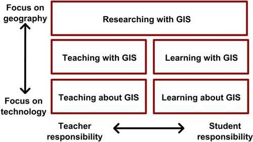
Specifically, Favier (Citation2011) suggests various means to integrate GIS in geography, by varying the focus of the process (more technological or more geographical) or the responsibility of the teacher or student (teaching or learning). identifies five ways in which GIS can be incorporated into learning environments: 1. teaching about GIS, 2. teaching with GIS, 3. learning about GIS, 4. learning with GIS, and 5. researching with GIS.
Figure 1. Five ways to integrate GIS in geographic education after Favier (Citation2011).
This research paper focuses on the second and fourth ways of integrating GIS in geography (Favier Citation2011) – teaching and learning with GIS – as a cross-sectional approach, which is beginning to be introduced into university lectures (Lázaro y Torres, de Izquierdo Álvarez, and González Citation2016; Mathews and Wikle Citation2019); and secondary school classrooms (Buzo Citation2021), as a way of enriching the content, skills or competencies of geographic science. Although they are not currently integrated into the curriculum, authors such as Bednarz and van der Schee (Citation2006) argue for their inclusion. Furthermore, the use of geospatial technology at lower levels of education has become a global trend (Avdić, Drešković, and Mirić Citation2020), especially because they have been increasingly developed with a user-centered design (UCD) (Hong Citation2014, Citation2017).
The general objective of this paper is to investigate the advantages of using GIS in secondary and university geography teaching through teachers experienced in their use and on the key questions that teacher’s ask: what to teach? how to teach? and what will students learn? The aim is to identify teachers’ perspectives on who uses GIS in the teaching of geography, to find out the best methodological strategies used with GIS in its teaching-learning process, and its advantages and limitations.
It is assumed that GIS require experiential learning and a connection between GIS knowledge and application. For these reasons, it was considered that teachers who use them in university or secondary education would be better able to organize content and teaching methodologies. Thus, the Delphi technique has been employed, which represents a novel approach to previous research on this subject.
2. Methodology
2.1. Methodological design
Linstone and Turoff (Citation1975, 3) describe Delphi as ‘a method for structuring a group communication process so that the process is effective in allowing a group of individuals, as a whole, to deal with a complex problem’. The Delphi method is an iterative process to collect and distill the anonymous judgments of experts using a series of data collection and analysis techniques, interspersed with feedback. This approach is very effective when the goal is to improve our understanding of problems, opportunities, solutions, or develop forecasts (Hasson, Keeney, and McKenna Citation2000; Skulmoski, Hartman, and Krahn Citation2007) – more so when knowledge about a problem or phenomenon is incomplete. The feedback provided during the various consultation rounds allows participants to contrast opinions and to reformulate, refine and alter their own ideas (Ruiz Citation2012), which acts as a motivational catalyst.
2.2. Data-collection tool and participants
The research was conducted between July 2020 and April 2021 via email, and the information provided by the experts was collected through Google Forms. López-Gómez (Citation2018) points out that such tools facilitate planning, organization, communication and data storage, as well as assisting processing and analysis, as found in this work.
The research was structured in four phases:
Phase 1. Determining the central problem and establishing objectives: (1) identifying the usefulness of GIS in teaching geography; (2) specifying the best methodological strategies to guide the teaching-learning process of geography using GIS; (3) establishing the learning outcomes of geography students who have employed GIS.
Phase 2. Formation of a panel of experts, which required the selection and application of specific criteria. The experts had to be, or have been, geography teachers in secondary education or at universities, and teach geography in an innovative way, as shown by their participation in national or international conferences such as the National Congresses of the Spanish Association of Geography or EUROGEO (European Association of Geographers) Annual Conferences, and by their publications. Further, the experts had to have: i. motivation; ii. time; and iii. personal opinions supported by knowledge that went beyond general information (Ruiz Citation2012). With these criteria 40 teachers were invited to participate in the panel, who were selected on the basis of their papers in different conferences (this number is over the minimum number recommended by experts in this technique, which is 30 (Dimitrijević et al. Citation2012; Ruiz Citation2012; López-Gómez Citation2018)). Of these, 18 secondary school teachers and 19 university teachers from different regions of Spain responded (); forming a sample of 37 in total.
Table 1. Expert panel profile.
Phase 3. Establishment of the iterative procedure of the consultation rounds based on the exchange of information. Delphi starts with a qualitative approach through open questions in the first round () meaning that information can be added by respondents at this stage. The initial questions focus on the main learning and teaching pillars: the learning outcomes, the teaching and learning process; and GIS. All responses from the first round are formulated as a closed questionnaire in the second round, using the Likert scale from one to five, which is useful because of its simplicity and capacity to obtain a consensus through the grading of each concept’s importance. Coding and data reduction was undertaken manually by identifying key words and ideas from the experts’ replies in the first round. The differences highlighted led to the design of two questionnaires in the second round: one for secondary school teachers and the other for university lecturers.
Table 2. Open questions to be answered in the first round.
Phase 4. Analysis and interpretation of the quantitative results derived from the second round questionnaires.
3. Results and discussion
The results of the study presented below correspond to the second round, since the former were collected during the questionnaire design phase. The responses are structured by the questions formulated at the outset: what to teach, how to teach, and expected learning outcomes.
3.1. Panel of university teachers
3.1.1. What to teach?
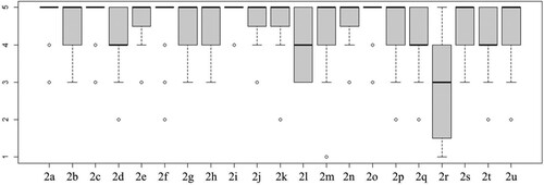
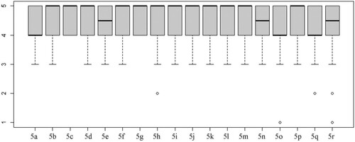
Most experts agree on the need for prior theoretical reflection on why and how GIS are used (78.9%) (a mean of 4.74 on the Likert scale) () (2a), which confirms the importance teachers give to their own teaching practice. They recognize the correlation between the methodological principles of geography (location, relationship, comparison and evolution) and GIS (84.2%) (a mean of 4.79) (2c). In this sense, the participants in this research fully agree with Roche (Citation2014), who states that a geospatial focus includes geographical scales, spatial analysis and research. GIS enable us to observe patterns, associations, and spatial order and allow us to apply the theory explained in class, and thus improve the understanding of content and connections between concepts (2f), they allow complex territorial analysis (2i) and the development of students’ spatial thinking (2o). However, there is less consensus that GIS is a discipline in itself rather than a geographical tool (2r) and that it encourages students to learn through play (1 l) ().
Figure 2. Opinions in relation to statements about GIS use (Likert scale).
3.1.2. How to teach?
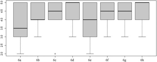
University teachers emphasize that GIS provide a practical way to teach and develop creative skills in digital mapping, with real and applied objectives. To this end, they use active methodological strategies which they consider the most effective, coinciding with those most widely used by the leading researchers in this field. Experts point out that the most widely-used techniques are (): (1) guided exercises, which exemplify the theory explained (Walsh Citation1992; U.S. Geological Survey Citation2005); (2) case studies; (3) those using GIS viewers to explain geographical issues (Rød, Larsen, and Nilsen Citation2010; Crespo Citation2020); (4) the Problem-Based Learning (PBL) approach, which has been advocated by a large number of teachers in other research (Liu et al. Citation2010; Kerski Citation2011). Less than half of the experts point to project-based learning, collaborative processes, discovery learning, or service learning; while one added the possibility of autonomous exercises and team projects.
Figure 3. Opinion on the teaching and learning methodology used with GIS (Likert scale).
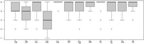
Other activities mentioned in the use of GIS are: the search for and use of data and official cartographic sources; the presentation of GIS viewers; story maps or geoportals; and the tool's own techniques, including geoprocessing and spatial analysis, from free and proprietary software. Fieldwork (3b) is not considered an essential element in GIS classes and neither are geographic readings. In both cases GIS can be an important complement to these activities.
3.1.3. Learning outcomes
One of the most widely agreed points is that students learn to analyze geographical phenomena using GIS while developing digital and spatial competencies. Following King (Citation2006) spatial competencies includes the spatial orientation (the ‘where?’ component), thinking and acting (where is it in relation to?), the spatial process (or what changes are taking place?), spatial systems (or how are they being affected?), the wider issues (or how does it connect with the outside world?), making decisions (or which solutions are there?) and, how can I make a difference?
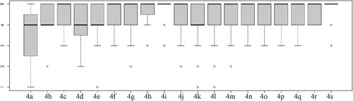
The statements that ‘GIS provide practical and applied learning in geography’ (4i) or that ‘they offer competency learning in geography’ (4s) were unanimously accepted. However, the statement that ‘GIS contribute to the learning of geography by making it possible to work on the territory without leaving the classroom’ (4a) proved to be the most controversial; which can be explained by the intrinsic need for direct observation of territory in geographical science; something that cannot be replaced by technological tools ().
Figure 4. Panelists’ views on the contribution of GIS to the learning of geography (Likert scale).
The practical and applied characteristics of GIS were also valued, as well as its capacity for unraveling complex territorial problems. The experts also highlighted the motivation it generates among students, which is in line with the work of Fargher (Citation2018) and De Miguel and de Lázaro (Citation2020) and the job opportunities it opens up (Musakwa Citation2017; Geobuiz Citation2019).
3.1.4. Problems identified
It is striking how little importance is given to technical problems, which can be interpreted as an improvement in university infrastructures, connectivity and software.
We can affirm that the GIS panorama as a cross-sectional element in teaching has changed, from learning by domains to learning across dimensions. However, some lectures do not currently use GIS as a teaching tool, perhaps because universities are more demanding in terms of administrative tasks, making the preparation of new teaching material with constantly evolving GIS tools increasingly difficult.
User-centered design (UCD) (Hong Citation2014, 2017) and user-friendly GIS are increasingly in demand; meaning that the field is broadening, due to the growing number of tools available, which are adaptable to all types of public. People even talk today of ‘Geographical Information Science’ and ‘Neogeography’. However, there are still gaps, as was exemplified by the fact that no panelist alluded to the importance of data interoperability.
3.2. Panel of secondary school teachers
3.2.1. What to teach?
The application of GIS makes it possible to work on real cases, rather than theoretical content exclusively, which boosts motivation, favors multi-causal analysis and encourages spatial thinking that allow different geographical elements and factors to be related (). It is a useful tool for spatial understanding, which derives from access to a large amount of data and its corresponding cartographic visualization, rather than content in itself as an object of study.
Figure 5. Clustering of responses to specific statements about the uses of GIS (Likert scale).
The main objectives for teachers using GIS are to: (1) stimulate students to carry out analyses of geographical phenomena (motivation); (2) present the results of these analyses in an appropriate graphical way (mapping); (3) select the official information necessary to carry out these analyses (spatial critical thinking, search for quality data); (4) awaken scientific curiosity and (5) use tools available in GIS software, such as those related to geolocation, referencing or measurements. In sum, GIS allow the study of geographical phenomena in a practical, attractive, and dynamic way in both teaching and learning.
3.2.2. How to teach?
Like university lecturers, secondary school teachers consider an active methodology: (1) is best suited to teaching with GIS; (2) encourages collaborative work; and (3) helps students participate in their own learning. GIS can also be used as an expository methodology to explain different geographical phenomena, and even in other subjects.
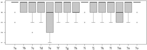
Among all teaching strategies (), the most highly valued was project-based work (Demirci et al. Citation2011); followed by field trips (Sebastián and De Miguel Citation2017; Digan Citation2019; Phantuwongraj, Chenrai, and Assawincharoenkij Citation2021). Next came three with similar values: problem-based work; discovery learning, which can be related to Kerski (Citation2011) and Favier’s (Citation2011) inquiry method; and finally, service learning. The least valued were cooperative work; game-based learning; and the inverted classroom (perhaps due to the difficulty of producing teaching videos, in which teachers have not been trained). This hierarchy is very similar to that found by previous research on teaching techniques for integrating Data Infrastructures in Secondary Education using GIS in the cloud (Álvarez-Otero and De Lázaro Citation2019; Álvarez-Otero Citation2020).
Figure 6. Clustering of responses relating to the assessment of different methodological strategies for implementing GIS (Likert scale).
3.2.3. Learning outcomes
There is a need to promote the teaching and learning use of GIS (), which is considered, together with other emerging technologies, as a tool with great future projection. It can guide teachers to teach in a different, more active way, and perhaps discard more rote strategies. The variety of content that can be addressed with GIS favors the discovery of interrelationships among diverse geographical elements: not only in analysis of the territory itself, with real and current examples; but also, through making proposals for improvement. GIS encourage creativity in students, as well as other qualities linked to the creation of GIS content, such as sharing the ‘creations’, and reusing the results obtained during the work. GIS is increasingly being used as an element of cross-subject collaboration and beyond, through learning across dimensions, such as competencies, instead of by domains (Rickles, Ellul, and Haklay Citation2017).
Figure 7. Clustering of responses to different statements on the teaching and learning use of GIS (Likert scale).
The panel of secondary education experts gave their opinion on content and competences in both curricular and organizational terms. Although recent Spanish education laws have given more weight to what are known as ‘basic competences’, which have been growing in importance; this does not mean that the role of other key curriculum elements, such as content, has diminished. Most experts argue that the education system should be based on competences, and not on content. For example, Schulze (Citation2021) argues that, from the perspective of the GIS and technology domain, GIS education at both school and higher education levels fosters a wide range of generic and subject-related competences.
3.2.4. Problems identified
The main difficulty detected in the use of GIS in secondary education relate to the teachers, as they have not been trained in their use, and need to acquire and update their digital competence. While some authors, such as Favier and van der Schee (Citation2014), argue that teachers do not need any additional skills, most argue that there is a clear need for teacher training (Buzo, Lázaro, and Mínguez Citation2014; Mathews and Wikle Citation2019), and specific courses to broaden teachers’ knowledge (Lay et al. Citation2013; Healy and Walshe Citation2020; MYGEO Citation2022).
Other difficulties include the limited time available in geography for the extensive syllabus to be covered, especially in the academic year before university, because the competitive university entrance exam conditions the teaching syllabus and calendar. Other issues are organizational, such as the high number of students per classroom, which is a barrier to the personalized teaching required by the active methodologies applied in this type of learning. This confirms Rickles, Ellul, and Haklay (Citation2017) assertion that teachers perceive GIS as difficult to use and to learn. Bednarz and van der Schee (Citation2006) confirm the issues identified by the experts as essential for the successful introduction and integration of GIScience in schools, including the need to address: (1) key internal issues related to GIS implementation; (2) teacher training, the availability of user-friendly software and Information and Communication Technology (ICT) equipment in schools; (3) the use of a ‘community of learners’ approach; (4) the institutionalization of GIScience into curricula, by ensuring that it is aligned with significant general learning goals like graphicacy, critical thinking and citizenship skills.
Technological improvements mean that GIS is no longer uniquely for specialists, and this is one reason that it is increasingly used in the classroom. Baker et al. (Citation2015) suggest a research agenda focused on four interrelated, connected, yet discrete, areas of investigation: the connections between geospatial technologies (GST) and geospatial thinking; how GST are learned in different contexts and by a range of individuals; what curriculum designs and materials facilitate learning; and how to prepare educators to implement GST (i.e. professional development).
4. Conclusions and recommendations
The results show that Spanish GIS expert teachers and lecturers agree on the importance of using this tool in the teaching-learning process, which coincides with other international authors (Abbott Citation2001; Fargher Citation2018; Milson, Kerski, and Demirci Citation2012). All contend that changes in methodologies are needed to integrate technical knowledge into teacher training (Bednarz and van der Schee Citation2006; Mathews and Wikle Citation2019). The growing implementation of GIS tools makes teacher training essential to enable the preparation of up-to-date and innovative materials. The use of GIS in teaching and learning activities requires active methodology strategies that require more time and training. These results have confirmed previous research in the national and international context.
This study found that regarding: (1) what to teach: GIS is unanimously believed to be useful in teaching and learning geography in a multidisciplinary way in many disciplines (such as archaeology, economics, environmental sciences, geography, urbanism and tourism among others; irrespective of the level at which teaching takes place), but that GIS use for learning across dimensions is still a difficult goal to achieve; (2) the teaching method: experts employ an active methodology, in which the teaching techniques prioritized experiential rather than rote learning; (3) learning outcomes: the experts agreed that experience in the use of GIS develops the ability to think critically, solve problems, exercise decision-making, and be more prepared for future global challenges. This is of great value in both academic and professional contexts. Further, its usefulness in promoting basic skills in citizenship education has been confirmed, as it is very useful in developing spatial thinking, as well as digital and communications literacy.
One problem is introducing GIS into teaching as a cross-sectional element, because of the lack of teacher training. This issue is gradually being addressed by technological advancements, which are making GIS more user-friendly; but on the other hand technological skills need to be continuously updated.
The Delphi technique has never previously been used to specifically demonstrate the usefulness of GIS in the teaching of subjects in which geo-technology information is employed, such as geography. However, Delphi has proven to be optimal for comprehensively capturing the range of expert opinions, and giving a voice to those who work directly with GIS in geographic education. This study improves knowledge of the effects of geography education with geospatial technologies; particularly GIS. From the answers obtained through Delphi we can see that GIS help achieve optimal learning results, as they allow practical and autonomous work on real cases, which generates dynamic and attractive learning situations that allow abstract and unknown concepts to be transferred to the real world. Furthermore, these technologies are useful for handling different prediction alternatives and choosing that which is the most appropriate.
Experts, who have been using GIS for years, confirm that they help to understand territory in an experiential and non-memoristic way, and enable the development of spatial thinking. These reasons together confirm that it is important to integrate GIS into teaching and learning activities at all levels. The new Spanish secondary geography curriculum favors methodological change and the use of GIS as a tool for teaching and learning geography.
In conclusion, it is recommended that new and different training channels are developed for teachers and lecturers, regardless of their area of work. This implies reinforcing specific education modules during university and complementing it throughout life with continuous training (lifelong learning), to prepare future educators for the technological, educational and other global challenges that lay ahead.
Informed consent statement
Informed consent was obtained from all subjects involved in the study.
Acknowledgments
The authors express their special thanks to the teachers of Geography who have participated in the study and to the innovation teaching UNED group Maps online for funding translation.
Disclosure statement
No potential conflict of interest was reported by the author(s).
Data availability statement
The data presented in this study are available on request from the corresponding author upon reasonable request.
Additional information
Funding
References
- Abbott, T. D. 2001. “An Evaluation of Geographic Information System Software and its Utility in Promoting the Use of Integrated Process Skills in Secondary Students.” PhD diss., University of Connecticut, Storrs. Accessed 18 January, 2022. https://opencommons.uconn.edu/dissertations/AAI3034002.
- Albăstroiu, I., M. Felea, and C. Vasiliu. 2014. “Geographic Information System - Modern Teaching Method in Business Administration.” Amfiteatru Economic Journal 16 (37): 770–783. Accessed 18 January, 2022. http://hdl.handle.net/10419/168856.
- Avdić, B., N. Drešković, and R. Mirić. 2020. “Attitudes among Geography Teachers in Bosnia and Herzegovina Toward Geospatial Technology use: Gender, age and Regional Differences.” Geographica Pannonica 24 (2): 136–146. doi:10.5937/gp24-24223.
- Álvarez-Otero, J. 2020. “El uso educativo de las Infraestructuras de Datos Espaciales (IDE) para mejorar la responsabilidad social de los ciudadanos del siglo XXI sobre el territorio.” PhD diss., Universidad Complutense de Madrid (España). Accessed 18 January, 2022. https://eprints.ucm.es/id/eprint/64592/.
- Álvarez-Otero, J., and M. L. De Lázaro. 2019. “Las Infraestructuras de Datos Espaciales: Un Reto y una Oportunidad en la Docencia de la Geografía.” Boletín de la Asociación de Geógrafos Españoles 82, doi:10.21138/bage.2787.
- Baker, T. R., S. Battersby, S. W. Bednarz, A. M. Bodzin, B. Kolvoord, S. Moore, D. Sinton, and D. Uttal. 2015. “A Research Agenda for Geospatial Technologies and Learning.” Journal of Geography 114 (3): 118–130. doi:10.1080/00221341.2014.950684.
- Bednarz, S., and J. van der Schee. 2006. “Europe and the United States: The Implementation of Geographic Information Systems in Secondary Education in two Contexts.” Journal of Technology, Pedagogy and Education 15 (2): 191–205. doi:10.1080/14759390600769573.
- Buzo, I. 2021. “Aprendizaje inteligente y pensamiento espacial en Geografía.” PhD diss., Universidad Complutense de Madrid, Spain.
- Buzo, I., M. L. de Lázaro, and C. Mínguez. 2014. “Aprendizaje y Enseñanza con Tecnologías Geoespaciales en España”. En Innovative Learning Geography in Europe: New Challenges for the 21st Century, editado R. por De Miguel and K. Donert, 77–86. Newcastle: Cambridge Scholars Publishing.
- Clagett, K. E. 2009. “Virtual Globes as a Platform for Developing Spatial Literacy.” PhD diss., Universidade Nova de Lisboa. Accessed 18 January, 2022. https://run.unl.pt/handle/10362/2317.
- Crespo, J. M. 2020. “El Visualizador Iberpix 4 del Instituto Geográfico Nacional: Un Recurso Didáctico Para la Interpretación de los Componentes Físicos del Paisaje.” Enseñanza de las Ciencias de la Tierra 27 (2): 182–191. Accessed 18 January, 2022. https://www.raco.cat/index.php/ECT/article/view/367134.
- De Lázaro-Torres, M. L., I. Buzo Sánchez, J. Álvarez-Otero, J. A. Barra Martínez, C. Carrapato, V. Cruz, A. E. Cselik, et al. 2022. “Biographical Map Library of European Authors.” http://www.biomaps.eu/wp-content/uploads/2022/05/posterAEGAN.jpg.
- De Miguel, R., I. Buzo, and M. L. de Lázaro. 2016. “New Challenges for Geographical Education and Researching: The Digital School Atlas.” In Crisis, Globalization and Social and Regional Imbalances in Spain. Spanish Contribution to 33rd IGU Congress. Beijing. doi:10.7419/162.02.2016.
- De Miguel, R., and M. L. de Lázaro. 2020. “WebGIS Implementation and Effectiveness in Secondary Education Using the Digital Atlas for Schools.” Journal of Geography 119 (2): 74–85. doi:10.1080/00221341.2020.1726991.
- Demirci, A., A. Karaburun, M. Ünlü, and R. Özey. 2011. “Using GIS-Based Projects in Learning: Students Help Disabled Pedestrians in Their School District.” European Journal of Geography 2 (2): 48–61. Accessed 18 January, 2022. http://eurogeojournal.eu/articles/4-Demirci.pdf.
- Dewa, P., B. Mulyanti, and I. Widiaty. 2020. “Geographic Information System in Education.” In IOP Conference Series: Materials Science and Engineering 830 (4): 042097. doi:10.1088/1757-899X/830/4/042097.
- DiBiase, D., K. E. Foote, N. J. Tate, and D. J. Unwin. 2012. “Ways Forward for GISandT Education.” In Teaching Geographic Information Science and Technology in Higher Education, edited by D. J. Unwin, K. E. Foote, N. J. Tate, and D. DiBiase, 453–467. Chichester: Wiley-Blackwell.
- Digan, S. 2019. “Integrating GIS in Experiential Fieldwork.” Geographical Education (Online) 32: 26–29. Accessed 18 January 2022. https://search.informit.org/doi/abs/10.3316/ielapa.882183728570404.
- Dimitrijević, B., V. Simic, V. Radonjic, and A. Kostic-Ljubisavljevic. 2012. “The Delphi Method as a Research Tool: An Application in Transportation and Logistics Systems Evaluations.” The 6th International Quality Conference. Center for Quality, Faculty of Engineering, University of Kragujevac (Serbia). doi:10.13140/RG.2.1.1798.6646.
- DOLETA (Department of Labor’s Employment and Training Administration. 2010. Geospatial Technology Competency Model (GTCM). Washington, DC: Education and Training Administration, United States Department of Labor.
- Fargher, M. 2018. “WebGIS for Geography Education: Towards a GeoCapabilities Approach.” ISPRS International Journal of Geo-Information 7 (3): 111. doi:10.3390/ijgi703011.
- Favier, T. 2011. “Geographic Information Systems in Inquiry-Based Secondary Geography Education: Theory & Practice.” PhD diss., VU University Amsterdam. Accessed 18 January, 2022. http://www.timfavier.com/dissertation.html.
- Favier, T., and J. van der Schee. 2014. “The Effects of Geography Lessons with Geospatial Technologies on the Development of High School Students’ Relational Thinking.” Computers & Education 76: 225–236. doi:10.1016/j.compedu.2014.04.004.
- Geobuiz. 2019. “Geospatial Industry Outlook & Readiness by Geospatial Media & Communication.” Accessed 7 January, 2022. https://geobuiz.com/geobuiz-report-2019/view-report.html.
- Hagevik, R. A. 2003. “The Effects of Online Science Instruction Using Geographic Information Systems to Foster Inquiry Learning of Teachers and Middle School Science Students.” PhD diss. Accessed 18 January 2022. http://www.lib.ncsu.edu/resolver/1840.16/4389.
- Hasson, F., S. Keeney, and H. McKenna. 2000. “Research Guidelines for the Delphi Survey Technique.” Journal of Advanced Nursing 32 (4): 1008–1015. doi:10.1046/j.1365-2648.2000.t01-1-01567.x.
- Healy, G., and N. Walshe. 2020. “Real-world Geographers and Geography Students Using GIS: Relevance, Everyday Applications and the Development of Geographical Knowledge.” International Research in Geographical and Environmental Education 29 (2): 178–196. doi:10.1080/10382046.2019.1661125.
- Hong, J. E. 2014. “Promoting Teacher Adoption of GIS Using Teacher-Centered and Teacher-Friendly Design.” Journal of Geography 113 (4): 139–150. doi:10.1080/00221341.2013.872171.
- Hong, J. E. 2017. “Designing GIS Learning Materials for K–12 Teachers.” Technology, Pedagogy and Education 26 (3): 323–345. doi:10.1080/1475939X.2016.1224777.
- Kerski, J. J. 2000. “The Implementation and Effectiveness of Geographic Information Systems Technology and Methods in Secondary Education.” PhD diss., University of Colorado, Boulder, USA.
- Kerski, J. J. 2003. “The Implementation and Effectiveness of Geographic Information Systems Technology and Methods in Secondary Education.” Journal of Geography 102 (3): 128–137. doi:10.1080/00221340308978534.
- Kerski, J. J. 2008. “The Role of GIS in Digital Earth Education.” International Journal of Digital Earth 1 (4): 326–346. doi:10.1080/17538940802420879.
- Kerski, J. J. 2011. “Sleepwalking Into the Future – The Case for Spatial Analysis Throughout Education.” In Learning with GI 2011, edited by T. Jekel, A. Koller, K. Donert, and R. Vogler, 2–11. Berlin: Herbert Wichmann Verlag, VDE VERLAG GMBH.
- Kerski, J. J. 2015. “Understanding Data: It is Critical!” Accessed 7 January, 2022. https://spatialreserves.wordpress.com/2015/11/22/understanding-your-data-it-is-critical/.
- Kerski, J. J., and T. R. Baker. 2019. “Infusing Educational Practice with Web-GIS.” In De Miguel González, R; Donert, K. & Koutsopoulos, K. (Eds.). Geospatial Technologies in Geography Education (pp. 3–19). EUROGEO Book Series: Key challenges in Geography. Suiza: Springer. doi:10.1007/978-3-030-17783-6_1.
- Kim, M., and R. Bednarz. 2013. “Development of Critical Spatial Thinking Through GIS Learning.” Journal of Geography in Higher Education 37 (3): 350–366. doi:10.1080/03098265.2013.769091.
- King, H. 2006. “Understanding Spatial Literacy: Cognitive and Curriculum Perspectives.” Planet 17: 26–28. doi:10.11120/plan.2006.00170026.
- Klingman, L. L. 2021. “Let's Get Digital! Using ESRIs ArcGis StoryMaps as an Archaeological Education Tool” PhD diss., State University of New York at Binghamton. https://bit.ly/3f2RsFE.
- Lay, J. G., Y. L. Chi, Y. S. Hsieh, and Y. W. Chen. 2013. “What Influences Geography Teachers’ Usage of Geographic Information Systems? A Structural Equation Analysis.” Computers & Education 62: 191–195. doi:10.1016/j.compedu.2012.10.014.
- Lázaro y Torres, M. L., S. de Izquierdo Álvarez, and M. J. González. 2016. “Geodatos y paisaje: de la nube al aula universitaria.” Boletín de la Asociación de Geógrafos Españoles 70. doi:10.21138/bage.2175.
- Lemberg, D., and J. P. Stoltman. 1999. “Geography Teaching and the new Technologies: Opportunities and Challenges.” Journal of Education 181 (3): 63–76. doi:10.1177/002205749918100305.
- Linstone, H. A., and M. Turoff, eds. 1975. The Delphi Method, 3–12. Reading, MA: Addison-Wesley.
- Liu, Y., E. N. Bui, C. H. Chang, and H. G. Lossman. 2010. “PBL-GIS in Secondary Geography Education: Does it Result in Higher Order Learning Outcomes?” Journal of Geography 109: 150–158. doi:10.1080/00221341.2010.497541.
- López-Gómez, E. 2018. “El Método Delphi en la Investigación Actual en Educación: Una Revisión Teórica y Metodológica.” Educación XX1 21 (1): 17–40. doi:10.5944/educXX1.20169.
- Martínez-Hernández, C., C. Yubero, E. Ferreiro-Calzada, and S. Mendoza-de Miguel. 2021. “Didactic use of GIS and Street View for Tourism Degree Students: Understanding Commercial Gentrification in Large Urban Destinations.” Investigaciones Geográficas 75: 61–85. doi:10.14198/INGEO2020.MYFM.
- Mathews, A. J., and T. A. Wikle. 2019. “GIS&T Pedagogies and Instructional Challenges in Higher Education: A Survey of Educators.” Transactions in GIS 23 (5): 892–907. doi:10.1111/tgis.12534.
- Milson, A. J., J. J. Kerski, and A. Demirci. 2012. The World at Their Fingertips: International Perspectives on Teaching and Learning with GIS in Secondary Schools. New York: Springer. doi:10.1007/978-94-007-2120-3.
- Mínguez, C. 2021. “Teaching Tourism: Urban Routes Design Using GIS Story Map.” Investigaciones Geográficas 75: 25–42, https://doi.org/10.14198/INGEO2020.M.
- Musakwa, W. 2017. “Perspectives on Geospatial Information Science Education: An Example of Urban Planners in Southern Africa.” Geo-spatial Information Science 20 (2): 201–208. doi:10.1080/10095020.2017.1339403.
- MYGEO. 2022. “Geotools for Teachers.” Accessed 27 January. 2022. https://iedra.uned.es/courses/course-v1:UNED(GeoTIG_Teachers_03(2022/about)).
- Petras, V., A. Petrasova, B. Harmon, R. Meentemeyer, and H. Mitasova. 2015. “Integrating Free and Open Source Solutions Into Geospatial Science Education.” ISPRS International Journal of Geo-Information 4 (2): 942–956. doi:10.3390/ijgi4020942.
- Phantuwongraj, S., P. Chenrai, and T. Assawincharoenkij. 2021. “Pilot Study Using ArcGIS Online to Enhance Students’ Learning Experience in Fieldwork.” Geosciences 11 (9): 357. doi:10.3390/geosciences11090357.
- Pons, J. J., J. Armendariz, and J. Andreu. 2019. “El Story-map como Herramienta Didáctica y Divulgativa en el ámbito de la Arqueología.” In X Jornadas de Investigación en Innovación Docente: Innovación Educativa en la era Digital, edited by C. Ortega, M. Á. López-González and P. Amor, 311–316. Madrid: UNED. http://arcg.is/0frOXW.
- Rickles, P., C. Ellul, and M. Haklay. 2017. “A Suggested Framework and Guidelines for Learning GIS in Interdisciplinary Research.” Geo: Geography and Environment 4 (2): e00046. doi:10.1002/geo2.46.
- Roche, S. 2014. “Geographic Information Science I: Why Does a Smart City Need to be Spatially Enabled?” Progress in Human Geography 38 (5): 703–711. doi:10.1177/0309132513517365.
- Rød, J. K., W. Larsen, and E. Nilsen. 2010. “Learning Geography with GIS: Integrating GIS Into Upper Secondary School Geography Curricula, Norsk Geografisk Tidsskrift - Norwegian.” Journal of Geography 64 (1): 21–35. doi:10.1080/00291950903561250.
- Ruiz, J. I. 2012. Metodología de la investigación cualitativa. 5th ed. Bilbao: Universidad de Deusto.
- Santos, B., J. Gonçalves, A. M. Martins, M. T. Pérez-Cano, E. Mosquera-Adell, D. Dimelli, A. Lagarias, and P. G. Almeida. 2021. “GIS in Architectural Teaching and Research: Planning and Heritage.” Education Sciences 11: 307. doi:10.3390/educsci11060307.
- Schulze, U. 2021. “GIS Works!”—But why, how, and for Whom? Findings from a Systematic Review.” Transactions in GIS 25 (2): 768–804. doi:10.1111/tgis.12704.
- Sebastián, M., and R. De Miguel. 2017. “Geographical Education 2020: Iberpix and Collector for ARCGIS as Teaching Resources for Spatial Learning.” Didáctica Geográfica 18: 313–316. Accessed 7 January, 2022. https://didacticageografica.age-geografia.es/index.php/didacticageografica/article/view/402.
- Skulmoski, G. J., F. T. Hartman, and J. Krahn. 2007. “The Delphi Method for Graduate Research.” Journal of Information Technology Education: Research 6 (1): 1–21. Accessed 7 January, 2022. https://www.learntechlib.org/p/111405/.
- U.S. Geological Survey (USGS). 2005. “Geographic Information Systems in Education.” U.S. Department of the Interior.
- Walsh, S. 1992. “Spatial Education and Integrated Hands-on Training: Essential Foundations of GIS Instruction.” Journal of Geography 44 (2): 54–61. doi:10.1080/00221349208979079.
- Wilson, B. 2019. “Forum for Social Economics Using GIS to Advance Social Economics Research: Geocoding.” Aggregation, and Spatial Thinking. Forum for Social Economics, doi:10.1080/07360932.2018.1509798.
- Wu, H., A. Lin, K. C. Clarke, W. Shi, A. Cardenas-Tristan, and Z. Tu. 2021. “A Comprehensive Quality Assessment Framework for Linear Features from Volunteered Geographic Information.” International Journal of Geographical Information Science 35 (9): 1826–1847. doi:10.1080/13658816.2020.1832228.
- Zwartjes, L., and M. L. de Lázaro. 2019. “Geospatial Thinking Learning Lines in Secondary Education: The GI Learner Project.” In Geospatial Technologies in Geography Education, edited by K. Koutsopoulos, R. de Miguel González and k. Donert, 41–61. Cham: Springer. doi:10.1007/978-3-030-17783-6_3.