
ABSTRACT
The concept of Digital Earth (DE) was formalized by Al Gore in 1998. At that time the technologies needed for its implementation were in an embryonic stage and the concept was quite visionary. Since then digital technologies have progressed significantly and their speed and pervasiveness have generated and are still causing the digital transformation of our society. This creates new opportunities and challenges for the realization of DE. ‘What is DE today?’, ‘What could DE be in the future?’, and ‘What is needed to make DE a reality?’. To answer these questions it is necessary to examine DE considering all the technological, scientific, social, and economic aspects, but also bearing in mind the principles that inspired its formulation. By understanding the lessons learned from the past, it becomes possible to identify the remaining scientific and technological challenges, and the actions needed to achieve the ultimate goal of a ‘Digital Earth for all’. This article reviews the evolution of the DE vision and its multiple definitions, illustrates what has been achieved so far, explains the impact of digital transformation, illustrates the new vision, and concludes with possible future scenarios and recommended actions to facilitate full DE implementation.
1. Introduction
The concept of DE was formalized by Gore (Citation1998). At that time, when the technologies needed for its implementation were in an embryonic stage, the US government called for specific public investments in research and technological development. Since then, science and technology have made significant progress in showing how the original vision could be achieved.
New technologies have emerged that were unknown at the time of Al Gore’s speech. These technologies strengthen and accelerate the implementation of DE, rather than affecting the original vision. Answers to, ‘What is DE today?’ can be found by considering how users and stakeholders can now use and contribute to its implementation, i.e. from users to ‘producers’ (Bruns Citation2007). The speed and pervasiveness of digital technologies are transforming our society, raising new questions in relation to, for example, ethics, digital governance, and cybersecurity. The transformative potential and opportunities for DE can be understood through the appreciation of diverse viewpoints spanning scientific, technological, social, and economic aspects, with a widespread implementation key to addressing the wicked problems of our generation.
Given the above, the purpose of this reflective article is to consider DE from a holistic perspective, learning lessons from past implementation or current initiatives and future plans. Although the literature is full of scientific articles (e.g. on the development of DE platforms or on the value of DE for specific applications), there are gaps on other aspects related to the realization of DE vision that we delve into in this article. DE is perhaps well known in the scientific community thanks to the efforts of the International Society for Digital Earth (ISDE) in sharing knowledge, but the involvement of people and industry is lacking. In this article, we also explore the question: ‘How can DE become a true collaborative laboratory without walls, and a digital market as envisaged in the original vision?’.
There are also specific issues related to the availability and usability of DE worldwide that need to be addressed, considering education and capacity building, government action and partnerships with industry. The role of the gaming industry is crucial to increase usability software ecosystems needed for DE and ensure people’s engagement, and needs to be further enabled considering that one-third of the planet’s population plays video games (UNEP Citation2022). At the same time, we must not only connect DE to social media to benefit from these self-updating data sources, but also to understand the impact of emerging metaverses as new platforms for collaboration, debate, and decision-making. Furthermore, the link between DE and art needs to be embraced because both science and art are fundamentally concerned with exploring and discovering the unknown.
The article is organized as follows: Chapter 2 describes the origin of the DE concept and vision, focusing on what has been achieved (i.e. DE past). Chapter 3 examines the ongoing discussion on the concept and definition of DE (i.e. DE present – Part 1). Chapter 4 analyses the impact that the digital transformation of society, including the many technological revolutions and emerging societal challenges, has had on DE (i.e. DE present – Part 2). Chapter 5 presents the perspectives and possible evolution of the concept and functionalities of DE (i.e. DE future – Part 1), including the contribution of DE to the United Nations Sustainable Development Goals. Chapter 6, provides some recommendations on evolution of ISDE actions, and possible directions to successfully implement the DE vision, effectively (DE future – Part 2: i.e. toward an operational DE). Finally, Chapter 7 highlights the novel principles of the DE vision and draws conclusions.
2. The origin of Digital Earth ‘DE’
2.1. The DE vision
The vision of a Digital Earth is already found in ancient literature and art before the existence of computers. More recently a precursor of DE can be found in Fuller’s work that proposed the creation of the Geoscope as the forerunner of DE (Fuller Citation1981). In the modern era, the DE initiative was established and led by NASA as a result of Al Gore’s position as US Vice President (Foresman Citation2008). In 1992, in his book ‘Earth in the Balance: Ecology and the Human Spirit’, Gore used the term Digital Earth (DE), referring to a system that ‘would integrate all that is known about the planet’ (Gore Citation1992).
Successively, Gore articulated the vision of ‘Digital Earth’ as
a multi-resolution, three-dimensional representation of the planet that would make it possible to find, visualise and make sense of vast amounts of geo-referenced information on physical and social environments. Such a system would allow users to navigate through space and time, accessing historical data as well as future predictions (based for example on environmental models), and would support its use by scientists, policymakers and children alike. (Gore Citation1998)
In 1999, the Chinese Academy of Sciences responded by holding the first International Symposium on Digital Earth in Beijing, and in 2006, the International Society for Digital Earth (ISDE) was establishedFootnote1 Since then, the DE’s vision has been discussed and reviewed by several authors. Goodchild (Citation1999) has outlined some of the research problems that arise from the original, Leclerc et al. (Citation1999) presented number of problematic issues for navigating a large globe structure and proposed solutions to allow users to interact with DE efficiently and seamlessly. Grossner, Clarke, and Goodchild (Citation2008), on the 10-year anniversary of Gore’s speech, reviewed DE from the perspective of a systematic software design process and found the envisioned system was in many respects inclusive of concepts of distributed geo-libraries and digital atlases. They offered and discussed a preliminary definition for a particular digital earth system as, ‘a comprehensive, distributed geographic information and knowledge organization system’ (Grossner, Clarke, and Goodchild Citation2008).
In a position paper, Craglia, Goodchild, and Annoni (Citation2008) argued that DE’s vision needed to be re-evaluated in the light of the many developments that had occurred in the fields of information technology, data infrastructures, and earth observation. Craglia, Goodchild, and Annoni (Citation2008) focused the vision on the next generation DE and identified 10 priority research areas to support this vision, namely: (1) Information integration; (2) Spatio-temporal analysis and modelling; (3) Schemes for tiling the curved surface of the Earth and for use in data management, analysis, simulation, visualization; (4) Intelligent descriptions of data, services, processes, models, searching and filtering; (5) Visualization of abstract concepts in space; (6) Computational infrastructures to implement the vision; (7) Trust, reputation and quality models for information and services provided; (8) Governance models and collaborative frameworks; (9) Data sharing and open access policies; and (10) Social and economic impacts of DE.
De Longueville et al. (Citation2010) considered DE as a powerful metaphor for organising and accessing digital information through a multi-scale three-dimensional representation of the globe but not yet self-aware. The authors argued that further integration of the temporal and voluntary dimension is needed to better represent the event-based nature of our world (De Longueville et al. Citation2010). They therefore aimed to extend DE vision with a nervous system to provide decision-makers with improved warning mechanisms. Annoni et al. (Citation2011) carried out a SWOT (Strengths, Weaknesses, Opportunities, and Threats) analysis of the DE vision and highlighted a number of key areas to advance the development of DE from a European perspective, namely: (1) integration of scientific research in DE; (2) exploit the Observation Web with human-centred sensing; and (3) governance including stronger linkages to funding streams and initiatives. This SWOT analysis remains a valid tool for the new vision, even if some of the weaknesses and opportunities have now been addressed.
Around the same time, Goodchild (Citation2012) acknowledged the role played by DE in spurring the development of the first generation of virtual globes but identified that a new area of ‘Big Data’ had arrived, as the public was more engaged with technology through citizen-science and crowdsourcing. Other authors also raised the issue of a new governance model for DE as key to its successful implementation and public access to science (Goodchild et al. Citation2012). Along the same lines, Craglia et al. (Citation2012) identified the main policy, scientific and societal drivers for the development of DE, namely: (1) empowerment of individuals, organizations, governments, and society through the growing ubiquity of DE; (2) a code of ethics to regulate behaviour; and (3) Comprehensive Public–Private Partnership involving four key sectors of society – ‘Research, Government, Commerce, and Communities/Citizens (Civil Society)’. They also illustrated the multifaceted nature of a new vision grounding it with examples of potential applications.
The issue of DE governance and the use of personal data have therefore started to raise interest with regard to ethical and security aspects. For example, Ehlers et al. (Citation2014) proposed a suite of principles to guide the development of DE after reviewing several developments including those in health sensors and systems frameworks, considering the implications of DE for citizens and on citizen science, including those of ethics. Desha et al. (Citation2017) proposed three guiding ‘Pivotal Principles’ to enable prosperous life in the twenty-first century that collectively address spatial information, sustainable development, and good governance, namely: (1) open data; (2) real-world context; and (3) informed visualization for decision support.
In 2019, the first scientific book of DE, namely ‘Manual of Digital Earth’ was formally launched by ISDE and Springer (Guo, Goodchild, and Annoni Citation2019). This book contains 26 open-access chapters contributed by more than 100 authors from 18 countries worldwide and has been downloaded nearly one million times in the first 3 years following publication. The Manual mainly covers the state and future directions of DE research, a systematic analysis of DE theories, methods, and technical systems, and a summary of the main achievements to date. It also predicts the likely direction and probable future developments within the discipline.
2.2. DE achievements
Since Al Gore’s speech in 1998, several virtual globes have been released by industry (Google Earth, Microsoft Bing, ESRI ArcGIS Explorer, Virtual-Geo, etc.) and public agencies (e.g. NASA released an open-source version named WorldWind). However, while the success of Google Earth has been used to argue that the original vision has been achieved, we believe that a virtual globe is far from a complete DE as argued by Grossner (Citation2007) in his article
Is Google Earth ‘Digital Earth’? Defining a vision’, where he wrote ‘Digital Earth has been and will be applied to many efforts and products and has come to represent a very loosely organized international effort to build comprehensive digital representations of Earth. However, nearly all organizations self-identified as working on Digital Earth-related projects are addressing only aspects of such representations particular related technologies, or geographical regions. The potential breadth and depth of a comprehensive Digital Earth is so vast as to make a complete specification unwarranted and probably impossible.
It is interesting to study Gore’s vision as the original proponent of the term, and compare it to where we are today. In , we list the elements included in his original talk (Gore Citation1998) and reflect on what has been accomplished so far.
Table 1. Key elements of Gore’s Citation1998 vision and evaluation of achievements.
Our assessment, as presented in , is that nearly all elements of Gore’s DE vision have become achievable today through technological advances although many of them still need refinements. The main challenges that remain are to create a collaborative framework for individual, researchers, companies, and government to facilitate a more systematic and combined use of these technologies and to remove barriers to wider diffusion as there are still a limited number of applications based on DE.
As discussed in the previous paragraphs, the DE vision has been reviewed on several occasions and in numerous publications. One way to revisit the vision is to compare the view of experts with different backgrounds. In 2011 a workshop on next-generation DE was held in Beijing hosted by the Center for Earth Observation and Digital Earth (CEODE) of the Chinese Academy of Sciences and the ISDE Secretariat. On that occasion, the DE vision was revised and a new vision for DE 2020 was formulated (Goodchild et al. Citation2012; Craglia et al. Citation2012). The new elements of the DE 2020 vision are listed in .
Figure 1. Outcome of the DE 2030 Workshop.
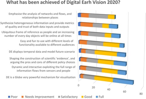
In preparation for a similar exercise, in February 2020 the ISDE conducted a survey on ‘Digital Earth Vision towards 2030’ with the aim of gathering opinions and reflections on the current state of DE and its development trend towards 2030. The survey has been active for one month, attracting 314 respondents (ISDE Citation2020). When answering the question ‘Do you think today the DE vision has been already implemented?’, only 20% answered ‘yes’, while 78% answered ‘partially’ and only 2% responded ‘none of the vision has been implemented’.
In July 2020, approximately 20 DE experts participated in online workshop on DE 2030 vision. The following question ‘What has been achieved of Digital Earth Vision 2020?’ was asked, and the results of the multiple choice answers are highlighted in .
According to the experts of this workshop (who were already familiar with DE), the vision of DE 2020 is far from being fully implemented. Furthermore, these experts considered it premature to draw a new vision for DE 2030, recommending instead to focus efforts on accelerating the implementation of DE 2020.
Gore’s (Citation1998) speech included a list of technologies needed for DE, and some examples of potential applications. Most of the envisioned technologies are now available along with relevant new technologies and methods, but we cannot claim that the potential of DE to support new applications has been fully exploited. Furthermore, the use cases discussed for DE 2020 (Craglia et al. Citation2012) are certainly not fully implemented. Taken together, advances in DE technologies have not yet been reflected in operational use of DE for decision support. Lessons learned in attempts to use DE for decision support are important in identifying the key actions needed in future refinements and effective implementation.
Reflecting on the opinion of some experts attending the 2020 workshop, we (the authors of this paper) believe that the digital transformation of the society requires considering new elements (including the scientific, social, and economic aspects) in addition to technological progress.
3. Defining DE
Can DE be clearly defined? Can we write precise technical specifications and smart objectives to evaluate its implementation? These questions have been addressed on multiple occasions. One of the conclusions of the ISDE Workshop on ‘Digital Earth Vision towards 2030 workshop’ Footnote2 is that there are many definitions of DE. They have been introduced in the past 20 years, and there are still many more today. According to the workshop conclusions, ‘It is not a bad thing to have different views about Digital Earth’. Like an octopus, DE can take on different forms by adapting to changes in the society and new technological developments.
However, the lack of a common and shared definition has some clear negative consequences on the definition and advancement of a specific DE science and technological framework, including knowledge consolidation, and prevention of duplication of efforts. Whereas there is a convergence among scientists to define (for example) the concept of Spatial Data Infrastructure (as a cluster of four main components: standards, services, data, and policies), a well-accepted (and reasonably limited) set of components/services to describe a DE framework doesn’t yet exist.
3.1. 2020 DE workshop and survey
In the survey organized by ISDE in 2020, 193 participants provided their definitions of DE (ISDE Citation2020). After generalizing and grouping them, the following main viewpoints emerged:
DE provides a (simple) digital representation of the Earth, i.e. a stack of data that has multiple dimensions and use and can be used by the society as a public good.
DE is a digital framework for developing a shared understanding of the complex relationships between society and the environment for the public good.
DE is the ultimate vision for a Digital Twin (Bauer, Stevens, and Hazeleger Citation2021; Voosen Citation2020) that couples the thermodynamic properties of our planet with associated environmental, economic, and social phenomena.
DE can effectively contribute by providing the important link between the real and the virtual words, with the aim of managing society, the environment, and the economy through a better understanding of the global versus local dynamics.
As for the last point, this definition is very close to the current meaning of metaverse, which refers to the concept of a highly immersive virtual world where people gather to socialize, play, and work (Mystakidis Citation2022). A link between the original DE vision and current extended reality technologies (including metaverse) is often expressed (Çöltekin et al., Citation2019b, Çöltekin et al. Citation2020), as these technologies and concepts are inherently synergetic with DE.
This multiplicity mirrors the many faces that characterize the DE domain. It recognizes that DE is a complex concept where different stakeholders can recognize their points of view focused on their different concerns. Only by considering the different concerns and visions, is it possible to lay the foundations for collaboration and increase the common good. Whichever definition is chosen (i.e. the selected facet), DE should take prominence in the ongoing discussions, by many international development agencies, on the importance of ‘digital public good’ to create a fairer world (e.g. UNICEF,Footnote3 UN,Footnote4 DGPAFootnote5) and for governments to implement their digital sovereignty programmes – e.g. OECD,Footnote6 A Europe fit for the Digital Age,Footnote7 DPG Charter.Footnote8 Ultimately, the true value of DE may lie in its values as a metaphor for increasing global understanding and communication across disciplines and between science, politics, and civil society.
We see in the related literature (as well as in the outcomes of the ISDE Citation2020 expert workshop) that DE cannot be a single platform but, rather, a system of multiple interconnected standalone platforms (possibly seamless). This is in line with the contribution of several stakeholders expressed by Gore, that ‘Rather than being maintained by a single organization, it would be composed of both publicly available information and commercial products and services from thousands of different organizations’ (Gore Citation1998).
According to Piascik (Citation2010), the full development and implementation of a ‘Digital Twin of the Earth’ will take many years before it can be made available. However, twins of Earth phenomena and/or subsystems (such as the Mediterranean Sea or the Po river basin in Italy) are more likely to develop. From the point of view of digitalization, the challenge concerns (once again) an innovative-distribution approach compared to one of traditional centralization. Furthermore, it is possible to talk about more or less automated ‘DT’ (see paragraph 5.1.3).
3.2. DE values and objectives
Looking at the various possible definitions gathered through the survey, we see that they lack an important connection to one of the elements of the original vision ‘Although some of the data for the Digital Earth would be in the public domain, it might also become a digital marketplace for companies selling a vast array of commercial imagery and value-added information services’ Gore (Citation1998). To date, the link between DE and the digital economy has not been adequately investigated by the scientific community. An attempt was made by Craglia and Pogorzelska (Citation2019) that approached the value of DE with a broad definition of economic value, i.e. the measure of benefits accruing from goods or services to an economic agent and the trade-offs the agent makes in consideration of scarce resources. They concluded that the economic value of DE depends critically on perspective: the value for whom, what purpose, and when.
Along with the digital transformation of our society, we have witnessed the growth of a digital economy (e.g. provision of digital services, e-commerce, etc.) successively articulated in the so-called platform economy, which refers to the economic and social activity facilitated by platforms. Such platforms can be online financial transaction, data and computational frameworks social media, … We believe that DE should be considered as one such platforms, or at least a technological framework that can have a dual use for the public good and for (new) businesses. This dual use must not generate conflicts. Indeed, the empowerment of entrepreneurial individuals can support the common good when entrepreneurs act responsibly.
This brief review shows that the concept of DE can have different values and goals but requires a comprehensive definition to facilitate better understanding and communication. The 2020 survey highlighted the lack of a single definition within the community, however, as often happens in these cases, it is possible to recognize important common aspects that characterize the main descriptions expressed by the experts: big Earth data sharing, the need to know users position, the generation of knowledge through complex analytical models, the use of immersive technologies, the use of scalable computing capabilities, etc. Thus, the definition and development of the concept of DE go hand in hand with the digital transformation of our society which, in turn, is determined by technological, economic, and political evolution. While the high-level DE concept remains consistent, it is generally accepted that the vision of DE could adapt the societal changes. This reflects the fact that the DE high-level framework is largely enabled by the Digital Transformation of society, while, on the other hand, the DE services help advance the digitalization of the society. Therefore, to understand the origins of the current definitions of DE and to propose a new and stronger vision (see Chapter 6.4), it is necessary to study the process of digital transformation of society and its infrastructures in the last decade and what will come in the next –that’s the focus of Chapters 4 and 5, respectively.
4. DE and permanent digital transformation
Over a period of the last 50 years, the digital revolution has changed all the sectors of our society, becoming essential to its functioning. Digital transformation refers to the profound changes taking place in the economy and society due to the adoption and integration of digital technologies into every aspect of human life. There are many definitions and perspectives on this phenomenon, but in a broad sense digitalization is about changes in business processes made possible by the transition from the physical to the virtual domain, and digital transformation deals with the outcome of these changes. This transformation induces changes in the behaviour of individuals and organizations in society and the boundaries of individuals and organizations. It has a pervasive impact on all activities, sectors, domains, and types of organizations.
There is a growing literature on our understanding of specific aspects of digital transformation, however, we lack a comprehensive portrait of its nature and implications. An extensive review has been provided by Vial (Citation2019) building a framework of digital transformation articulated across eight building blocks. Vial’s framework foregrounds digital transformation as a process in which digital technologies create disruptions by triggering strategic responses from organizations seeking to alter their value creation paths while managing the structural changes and organizational barriers affecting positive and negative outcomes of this process.
4.1. The importance of digital transformation
It has been proposed that digital revolution progresses in 10-year cycles, called ‘digital revolution generations’ (Hawtin Citation2020; Singh Karki and Garia Citation2016; Raval Citation2019). Today, we live in a digital transformation generation that offers important new paradigms, services, and tools to advance the implementation of the DE vision. The impact of digital transformation on DE can be broken down into three key processes, which contribute to realizing a digital transformation stack, where each layer of the stack builds on the previous one:
Enabling digital channels (including connected devices). The ubiquitous and pervasive connectivity to the network has created unprecedented opportunities for both data collection and reaching natural users and software clients. The speed and pervasiveness of digital technologies has created an unprecedent wave of structured and unstructured data by exploiting the proliferation of connected digital devices and sensing ‘things’. A large volume of heterogeneous datasets can now be downloaded and accessed, probably soon in almost any location and at any time.
Enabling Digital analytics. Online information is the new form of value (as the popular saying goes ‘data is the new oil’). It is produced by managing and processing the enormous amount of heterogeneous data continuously generated through innumerable digital sources and shared on the network. This process has driven the development of fully integrated digital platforms. Digital channels are used as communication and collaboration tools between users/customers and analytical platforms. The goal is to fully automate the value chain of analytical and processing to provide richer and more advanced services to users/customers. From an industrial point of view, this also allows for significant efficiency gains by reducing costs.
Enabling the Digital business model. To take full advantage of the digital transformation of societies, a change in usual business models is needed to reshape products and services. Often, this process is also called datafication. Technology must be used to design and implement the components and the services that characterize a given vision or conceptual framework. The paradigm and instruments of the digital transformation must be fully utilized throughout the services value chain. The datafication paradigm (Mayer-Schönberger and Cukier Citation2014) applies this concept by introducing a new business model, through the conversion of qualitative aspects of life into quantified data (Ruckenstein and Dow Schüll Citation2017).
The digital transformation has had a major impact on DE. This includes, for example, its content, how users can access the data, and how data could be transformed into information, first, and then actionable intelligence. The following paragraphs introduce some technological, social, and business changes from the original vision of DE. It is possible to recognize that they belong to the layers stack discussed earlier.
4.2. The evolution of digital channels
4.2.1. Digital networks – communication and information
5G (fifth-generation technology standard for broadband cellular) networks. The fifth generation (5G) of mobile networks enables a new generation of networks designed to connect virtually everyone and everything together including machines, objects, and devices. Surely, in the next 10 years 5G will be replaced by new, continuously improved generations ‘NGs’. The goal of 5G is to provide higher multi-Gbps (Gigabit per second) peak data speeds, ultra low latency, higher reliability, massive network capacity, higher availability, and a smoother user experience for more users (Qualcomm Citation2022). By providing higher performance and greater efficiency, this new generation of mobile networks has empowered new user experiences and connected new industries. According to Qualcomm (a leading wireless technology), the full economic effect of 5G adoption is likely to be realized worldwide by 2035, supporting a wide range of industries and potentially enabling up to $13.1 trillion worth of goods and services. The impact of 5G will therefore likely be much greater than that of 4G. While 5G can be a game changer, some challenges need to be addressed to fully deploy such technology in society, such as (a) deploy an ultra-dense grid by adding small-cell technology, in densely populated areas, together with the already existing macro-cell network; (b) face the significant costs necessary for the development of an ultra-dense grid; (c) address the issue of supporting hundreds of gigabits of traffic from the core network through backhaul and current cellular system technology; (d) address the impact of more base stations on rooftops to address the limitation of the short-wave spectrum usage (e) address security issues.
Ultra-high-speed broadband Internet. Ultra high-speed broadband Internet is the fibre to the premise broadband that is capable of providing a minimum downlink speed of 100 mbps and a minimum uplink speed of 50 mbps. Ultra-high-speed broadband internet is faster because uses fibre-optic cables, which transfer data at higher speeds than the copper wires typically used for traditional broadband. Research conducted by Ericsson, Arthur D. Little, and Chalmers University of Technology confirms that increased broadband speed contributes significantly to economic to identify the remaining scientific and technological challenges to growth. A new report quantifies the isolated impact of broadband speed, showing that doubling the broadband speed for an economy increases GDP by 0.3% (Arthur D. Little Citation2022).
Global Navigation Satellite System (GNSS). GNSS refers to a constellation of satellites providing signals from space that transmit positioning and timing data to GNSS receivers. The receivers then use this data to determine location. By definition, GNSS provides global coverage. Examples of GNSS include Europe’s Galileo, the USA’s NAVSTAR Global Positioning System (GPS), Russia’s Global’naya Navigatsionnaya Sputnikovaya Sistema (GLONASS), and China’s BeiDou Navigation Satellite System.
Personal and vehicle navigation systems. GNSS is used every day to plan human movements at an individual scale as well as institutional scales. In the last 15 years, navigation technologies have made significant progress, from separate devices (with pre-installed maps) to smartphone apps that define user’s location in seconds and suggest an optimized route or even lead to the necessary points of interest (Suddia Citation2022). Competition from private companies has pushed the market of positioning and navigation systems to provide detailed maps for all interesting points. More recently, competition has shifted from the device to the development of software applications (especially mobile Apps). The advent of 5G is going to revolutionize the industry by introducing new map-based services for smartphones. In the near future, indoor positioning (i.e. using Wifi) will become the next technological frontier.
The positioning and navigation software infrastructures (e.g. mobile apps and automotive software) play an important role to realize the DE vision.
Long time-series and nano satellite systems. For decades, some developed countries and unions have launched programmes including a variety of satellite missions and scientific instruments in orbit, designed for long-term regional or global observations of the land surface, biosphere, atmosphere, and oceans. Valuable examples of such programmes are the US LANDSAT satellites and the EU Copernicus/Sentinels satellites. The recent generation of satellites are operating sensors and instruments characterized by enhanced spatial, temporal, and spectral resolutions. Today, it is possible to access and use products and services online (which are routinely achieved by private and public companies) to detect changes over time and monitoring the conditions of natural systems and artefacts. These permanent observation systems constitute a new (global/regional) infrastructure that is already being used in many societal and economic sectors.
Another important innovation has taken place in the last 10 years: the so-called New Space revolution. It is a paradigm shift in the development of satellites for earth observation, as it has led to the creation of many small satellite systems (from 1 to 100 kg) which monitor a range of variables describing the biosphere, geosphere, hydrosphere, cryosphere, and atmosphere systems. More significantly, these miniaturized satellites have opened up the market for commercial projects (Zakšek, Oštir, and McCabe Citation2019). These small satellites have become platforms largely used to exploit space for sustainable socio-economic benefit. They are commonly known as ‘cubesats’, ‘nanosats’, or ‘microsats’ due to the limited size or weight, respectively. Such developments contribute to the ‘democratisation of space’ (European Commission (EC) Citation2022a), but also open up many potentially complex, social, and political challenges.
4.2.2. Digital devices – data and information
Mobile devices (smartphones). The well-established desktop metaphor does not fit well for DE because DE is envisioned to go beyond everyday computer use. Today, DE systems and applications commonly make use of smartphones and other mobile or wearable digital devices. The notion of virtual globe (as a powerful viewing mechanism) is still valid but has evolved from the original vision in many ways due to widespread adoption of the smartphones. In 2022, the number of mobile phone users (including both smart and feature phones) reached 7.26 billion, which represents 91% of world’s people who own mobile phones (Bankmycell Citation2022). Today, many users interact anytime and anywhere, known as ‘ubiquitousness’. However, despite this continued internet penetration, there is still a lot way to go to meet the seven 2025 Broadband Advocacy Targets, particularly in low-income countries, to a report by United Nations Broadband Commission (UN Broadband Commission Citation2022). A recent paradigm shift is represented by the (global) satellite internet constellations (elaborated in the dedicated paragraph 5.1.1).
The Internet-of-Things (IoT). The International Electrotechnical Commission (IEC) provides the following definition (in its online vocabulary) of IoT: ‘infrastructure of interconnected entities, people, systems and information resources together with services which processes and reacts to information from the physical world and virtual world’ (IEC Citation2020). IoT as a concept can be defined as a digital framework that enables the generation, transport, storage, and analysis of data to create actionable intelligence (Nativi et al. Citation2020). IoT platform’s contributes are ingested by the ‘datafication’ process that is at the hearth of the digital transformation. According to IBM, more than a decade ago, IoT devices overtook the number of humans on the Internet. However, those minimalist IoT devices of the past are very different from today’s tiny Internet-capable hardware (Darling Citation2021a). IoT has brought major changes and innovations across a broad spectrum of application domains.
Surveillance cameras. According to data collected by IHS Markit and first reported by The Wall Street Journal (Citation2019), one billion surveillance cameras would have been deployed globally by 2021. Especially in urban environments, these camera infrastructures (perhaps together with other IoT sensors) can be used to monitor the environment and improve sustainability (Kuhn et al. Citation2011).
Drones. Drones. Drones are vehicles with no human presence on board; an unmanned aerial vehicle (UAV) can fly autonomously and an unmanned ground vehicle (UGV) operates while in contact with the ground. Both could be controlled by a dedicated remote unit or be standalone. Autonomous drones are essentially robots that operate without the need for a human controller on the basis of artificial intelligence technologies. The vehicle uses its sensors to develop some limited understanding of the environment, which is then used by control algorithms to determine the next action to take in the context of a human-provided mission goal. In Aviation the origin of drones dates back to 1960s to meet the needs of government and the military for intelligent warfare devices (Jain Citation2020). However, with the advancement in technology, drones have been customized into various forms for many other applications of relevance for DE such as: creating 3D maps, surveying landscape, search and rescue missions, wildlife conservation, pipeline inspection, traffic monitoring, weather forecasting, and firefighting, agriculture, etc.
The number of drones in the air is expected to increase rapidly in the coming years. Global drone market size is forecast to reach US$55.8 billion by 2026 at 7.8% CAGR, with the commercial market growing at 8.3%. Mapping & surveying is and will most likely remain the top drone application, followed by inspection as well as photography & filming (Zmitko et al. Citation2021). The commercial drone market today is led regionally by Asia thanks to China and Japan, while South America and India are growing fastest at the regional and country levels, respectively (Drone Industry Insights Citation2020).
The rise in the number of drones raises new ethical (de Miguel Molina and Segarra Oña Citation2018) and security issues and will put enormous pressure on the systems of permits and exemptions that most countries require for drone use. Large numbers of drones will also put the enforcement of such rules under pressure. Even though the idea is sometimes brought up, banning drones from society does not appear to be a realistic option. Thus, properly regulating the use of drones to avoid or minimize the risks associated with the use of drones becomes critical. Expanding the possibilities for drone use while maintaining safety requirements would meet the demands of many drone user groups and would help to regulate technological developments (Custers Citation2016).
Drone technology is constantly evolving. Many drones today include AI. The combination of AI and drones makes possible real-time classification for people/animals/artefacts detection in the video stream, including managing large amounts of collected data (edge computing) (McEnroe, Wang, and Liyanage Citation2022).
4.3. Evolution of digital analytics
High-performance and cloud (computing) infrastructures. In the original DE vision, data availability was a key challenge. We are currently seeing an unprecedented growth of information generated worldwide and on the Internet which has led to the concept of big data. Big data is characterized by its five Vs: Velocity, Volume, Value, Variety, and Veracity (Nativi et al. Citation2015; Li et al. Citation2015). It is impossible to analyse data manually as it was done in the past. Therefore, for big data, it is necessary the use of high-performance computing platforms and intelligent data management techniques supported by machine learning and AI. The advancement of high-performance and scalable computing (in particular, public cloud computing platforms) has provided the necessary, effective, and (often) easy-to-use infrastructure to process such large amounts of data in near real-time. Furthermore, these infrastructures give people the ability to collaboratively perform process modelling, simulation, and virtual experiments in cyberspace (Chen et al. Citation2020), equipping DE with more powerful analysis capability. Cloud infrastructures and platforms respond to the society’s demand of digital services which, in turn, leverages the ubiquitous connectivity of the population, and therefore the big (and often public) communications infrastructures. A major challenge for cloud infrastructures and platforms is the lack of effective interoperability. The issue of multi-cloud interoperability and cloud portability is becoming increasingly more important for enterprises, which commonly use more than one cloud platform (see paragraph 5.2.1). To solve this problem, new legal regulations and standards are being developed.
New spring of (data-driven) AI. AI has been around since the 1950s and has gone through many cycles of hype and ‘winters’. AI is experiencing a new spring these days, and this time, it may be here to stay. AI is a generic term that refers to any machine or algorithm capable of observing its environment, learning, and, based on the knowledge and experience gained, taking intelligent actions, or proposing decisions. There are many different technologies that fall under this broad definition of AI. For the current digital transformation, machine learning (ML) techniques are the most used. ML along with its subset of techniques called deep learning (DL) are also essentially data-driven AI, because they require a consistent amount of data/observations to implement self-learning (or training) phase. ML-based technologies have become very important thanks to recent advances in computing power, data availability, and new algorithms (Craglia et al. Citation2018). Many applications of ML have begun to enter our daily live (e.g. machine translations, image recognition, autonomous vehicles) and are increasingly being exploited in industry, government, and commerce. We are only at the beginning of this process because the development of ubiquitous sensor networks, the IoT, is exponentially increasing the sensing capabilities of AI, the volumes of data on which to train the algorithms, and their reach in society through decisions and actions.
To implement and advance the DE vision, while cloud computing infrastructures can provide the necessary (computing, storage, and networking) scalability, AI in general and ML in particular can provide the effective and flexible tools to extract actionable insights from the deluge of natural and social data generated every day or even every hour in the world.
Data cubes and the ARD platforms. With the advent of the data deluge, the need for new data storage structures and access interfaces emerged. Also, the old paradigm discovering, accessing, and downloading data (to be processed locally) was not longer possible, in several use cases. This is remarkable and true in the case of long satellite-based time series data. Array-based DBs (a class of No-SQL databases that store, manage, and analyse data whose natural structures are arrays) were introduced to handle datasets generated and/or organized as multi-dimensional arrays (Misev Citation2018; Woodie Citation2014). Multi-dimensional array technology is at the hearth of data cube systems. Data cube cyber-infrastructures have recently gained a lot of attention in the domain of satellite imagery management. Data cube systems are understood as software infrastructures that allow the ingestion, storage, access, analysis, and use of data elements that are inherently ordered according to shared attributes, one of which must be their geospatial location (Nativi, Mazzetti, and Craglia Citation2017). Geospatial data cubes improve the connections between data, applications, and users by facilitating the management, access, and use of analysis ready data (ARD) (Giuliani et al. Citation2019) They have been shown to play a role in big Earth data analytics and are excellent tools to implement and facilitate the ‘temporality’ of the DE concept. Several space agencies consider this technology as a promising instrument to perform time-series analysis of large satellite data-sets like Landsat and Copernicus Sentinels.
To implement the DE vision, a major challenge is still represented by the limited level of interoperability that characterizes most of existing the cubes. This limitation, to some extent, is inherent in cube’s purpose to be ready to perform application-specific analysis (Nativi, Mazzetti, and Craglia Citation2017; Giuliani et al. Citation2019).
IoT 2.0 and the edge computing paradigm. While the impact of IoT on industry (i.e. IIoT) has yet to be fully understood, it is becoming increasingly clear that the emergence of a new generation of IoT (sometimes called IoT 2.0) has significantly enabled the digital transformation of our society. While IoT has connected billions of sensors to Internet, IoT 2.0 promises to make them smart and to revolutionize the digital-physical interaction patterns (Nativi et al. Citation2020), as in digital twins or extended reality applications. First-generation IoT devices are commonly sensors and actuators accessible via the Internet. Usually, they are unable to do any significant data processing locally, but they transfer their data to cloud computers, which perform analytical tasks. The second generation of IoT devices (i.e. edge devices) are edge computers with sensors and actuators directly connected to them, for example, they can run ML programmes to detect features, locally on the device. These edge devices can take actions in response to real-world events with very low latency (e.g. sub-millisecond). Edge computing is all about placing computational resources as close as possible to the source of the data and where the actions are to occur (Darling Citation2021b). The advent of 5G has motivated telecom providers to build large multi-access edge computing data centres at the far edges of their telecom networks. First and second-generation IoT represents a huge market. Funding increased from 2015 to 2016 also thanks to the significant contributions from sectors such as smart homes, smart cities, and connected services. Another important support has come from the development of IoT software platforms, which has recently mobilized significant investments.
For DE, IoT 2.0 and edge computing enable innovative applications in many areas including autonomous vehicles, agriculture, and healthcare.
Human-enriched digital content. Besides those mentioned above, there are many other digital devices that can be commonly used by anyone to collect information about the Earth, as discussed for example in ‘citizens as sensors’ (Goodchild Citation2007), including digital cameras and integrated digital surveying instruments in mobile devices (e.g. LIDAR in modern tablets). These technologies have been miniaturized and incorporated into tools available to the general public (e.g. smartphones, tablets, wearables devices such as smartwatches or rings) including registering location when collecting data through GPS receivers integrated in the devices. As a result, a proliferation of digital videos, digital photos, and digital audio (e.g. podcast) is now not only accessible on the web, but citizens can create and publish them without editorial interventions. In many cases, such content is directly linked to DE platforms. Therefore, it is now probably easy for most people to navigate through DE, identify a museum, and access an audio guide and/or a photo library. In recent decades, such digital content has been generated by both individuals and authorities. Therefore, today, enriched multimedia digital content is commonly available providing information about a specific place like never before in human history.
Visualization, Extended Reality, and Immersive Technologies. Due to its richness and complexity, making sense of the information that DE contains is even more difficult than its construction (Gore Citation1998). While we benefit from computational developments, we also need to enable humans, which makes it necessary to understand how humans process information. Given that much DE-related information is visual and spatial (or visuospatial), a key enabler that supports human sensemaking is the ability to visualize geospatial information. Çöltekin et al. (Citation2020) provide an overview of key aspects of visualizing geospatial information, including basic definitions and organization of visualization-related knowledge in the context of a future DE. The authors conceptualize DE as a fully functional extended reality (XR) system with a focus on virtual reality (VR). To build such a system, we need to master every aspect of the related technology and design and understand the capabilities, needs, and context of the users. Çöltekin et al. (Citation2020) recommend paying special attention to how XR environments (i.e. augmented (AR), mixed (MR), and virtual reality (VR)) can be used to enable a DE. The link between XR and DE is evident, as Gore’s original concept mentions data glove, virtual walk-, and fly-through experiences, all of which are native XR concepts. To make sense of the growing amount of data available, a major challenge is to organize these data on a global scale, for example by adjusting levels of detail (Çöltekin and Clarke Citation2011) and levels of realism (Lokka and Çöltekin Citation2017) to control the visual complexity of the displays and match the human visuospatial information processing abilities. In this way, we profit from the strength of visualization and analytics (i.e. visual analytics) (Çöltekin et al. Citation2019a). By visualizing the data in multiple ways, we can create and recreate experiences, observe patterns, and detect anomalies. By using XR systems we can immerse ourselves into the concepts and experience the consequences or our data analysis first-hand, with endless possibilities.
Current immersive technologies, especially MR devices, can integrate virtual content with the physical environment in a way that allows the user to interact naturally with mixed reality. Wortley (Citation2014) explores likely developments in immersive technologies and serious gaming and points to three main areas: attractiveness, accessibility, and affordability to focus on in order to succeed in an increasingly competitive environment. The recent advances in XR technologies, with the help of machine learning, computer vision, and photogrammetry, exceed the original Gore’s vision. The next decade is ripe with research opportunities at the intersection of DE and XR (Çöltekin et al. Citation2019b).
4.4. DE and the evolution of digital business model
4.4.1. The role of the private sector
In the 1990s, most of the relevant data for DE was collected by the public sector while today the private sector is predominant both as a data collector and as provider of platform to share data collected by individuals.
For example, there has been a huge shift in the Earth Observation (EO) market. Satellite imagery was one of the primary sources in Gore’s original vision and at the time most satellites for EO were operated by public governments. Today, we observe a rapid transformation of the space industry linked to the technological innovation in all components (launch systems, sensors, miniaturization of satellites- SmallSat, new architectures, … ) which have significantly reduced costs. Greater diversity and quality of sensors allows for greater spatial and spectral resolution, while a higher number of satellites ensures a higher temporal frequency. Their combination makes it possible to supply a wider range of information products and therefore a wider user base.
Frost and Sullivan’s Q1 2018 update of the ‘Small Satellite Launch Services Market’ estimated that more than 11,000 small satellites will be launched by 2030. The central value proposition these commercial players offer to end users is real-time imagery and seamless global connectivity. According to a report released by Space Capital, venture capital firms invested more than $17 billion in 328 companies, and the private investment market poured nearly $15 billion into the segment in the fourth quarter, with a total of 46.3 billions of dollars invested in all space technology stacks (Littlehales Citation2022).
As an alternative to data and services provided by the private sector, government programmes such as Copernicus, the European Union’s Earth observation programme, continue to offer free and openly accessible information services. During the planning stages of Copernicus, private satellite operators expressed a great deal of concern about the potential long-term evolution of the Copernicus programme, both in terms of users’ dependence on publicly funded data sources and the risk that future Sentinels will enter into the high-resolution territory. The market analysis conducted in 2013 (Copernicus Citation2013) showed that 83% of all commercial data sales came from optical solutions, amounting to approximately €0.9 billion in commercial revenues. 60% of all optical data sales were from very high-resolution data (accounted for the majority of data sales with Defense being a key customer with a clear preference for higher accuracy). As a result, Copernicus has been defined to have a resolution that does not interfere with private sector data maintaining their niche market for specific products and services.
In addition to satellite data, the private sector has invested in a large collection of other data types relevant for DE and in building platforms for their access and use. A significant example is Google Maps Street View. This platform provides an image-based virtual representation of our surroundings on Google Maps, made up of billions of panoramic images (Techcrunch Citation2022). Street View content comes from two sources: Google and contributors. Google uses cars that drive up and down the streets capturing everything in their special 360-degree cameras. Street View contributors use similar cameras to collect images of the sites they visit. This is a valuable example of the collective effort of private sector and crowdsourcing to allow people to virtually explore the world anywhere.
Another notable example comes from the company ClearView, which had the largest known database in the world in 2021 (more than 10 billion publicly available facial images), and is on track to have 100 billion facial photos in its database by 2021. At the end of 2023, a huge database is enough to ensure that ‘almost everyone in the world will be identifiable’ since 100 billion images would equal 14 photos for each of the approximately 7 billion people on Earth (Harwell Citation2022, Clear ViewFootnote9).
In his speech, Gore (Citation1998) stated: ‘Over the coming months, I intend to challenge experts from government, industry, academia and non-profit organizations to help develop a strategy to realize this vision’. At that time, the US government made specific public investments available to support the development of DE (for example, TerraVisionTM was an open source, distributed, interactive terrain visualization system developed in 1994 by SRI International with funding from the US Advanced Research Projects Agency under contract F19628-92-C-).
In the following years, the availability of public funds for DE has significantly reduced and the main development has been shifted to private sector investments. It is therefore useful to reflect on whether DE can be implemented in the absence of public funds dedicated to it. We prefer to approach the discussion by considering DE as a public good (i.e. as a framework or as an ecosystem accessible to anyone) which is an essential tool for generating the knowledge needed by policy makers to achieve the common good as discussed in chapter 3.
In economics, a public good (also known as a social good or collective good) is a non-excludable and non-rival good (Ingham Citation2018). For these goods, users cannot be prevented from accessing or using them due to non-payment. Also, use by one person does not prevent access by others or reduce availability to others. Public goods are important because they are designed to be available to the general public and possess specific qualities that prevent individuals or groups from accessing them. They must also be able to withstand use without becoming unavailable to future users.
In the absence of dedicated public funds, DE implementation is, and will continue to be, driven by two forces: industry players developing new technologies and providing new services, and academic teams promoting research into new methods, models, and applications for DE. Therefore, DE cannot be fully implemented without a clear commitment from industry and better collaboration between the scientific and business communities.
For example, Google Earth is an industry-led technology sometimes used by scientists to process and/or visualize data produced by research-driven models. As stated by Google,
Google Earth or Earth Studio can be used for purposes such as research, education, film and non-profit use without needing permission. All content created by Google Earth or Earth Studio must always be properly attributed. Google Earth content may not be used for commercial or promotional purposes.
A second example of the private sector contribution to DE falls under the category of donors . For example, Microsoft’s AI for EarthFootnote10 initiative has enabled individuals and organizations to develop innovative solutions for how we monitor, model, and ultimately manage the Earth’s natural systems through grants, technology, and access to data.
Despite the clear value of initiatives like the ones mentioned above, there is always a lack of a collaborative framework to ensure faster DE development and synergies between all ongoing efforts (i.e. to ensure the interoperability of various platforms and models and the sharing of all data collected).
DE has always been framed within the geospatial domain because the location is its key feature. The geospatial domains, both research and industry, have greatly benefited from substantial advances in computing and technology. In recent decades, these advances have not only made GIS technology much richer and more accessible, but have also helped the geospatial industry evolve. Today the geospatial industry has integrated many digital technologies (Artificial Intelligence, Cloud Computing, IoT, Building Information Modeling, Extended Reality, etc.) so there are fewer technological barriers in using multiple technologies together.
Recognizing the leading role of the Private Sector for the realization of DE specific attention should be given on how to build better partnership between the private sector, the government, and the people. The digital ecosystem model (described in 5.2.1.) seems to fit particularly well with the ever-changing nature and needs of the cyber-physical, where heterogeneous stakeholders can decide to cooperate from time to time and on a use case base.
4.4.2. Citizen science, crowdsourcing, and personal data
The internet provides an opportunity for the public to contribute to the development of DE. EO is a collection of information about the planet and it isn’t limited only to the technologies that provide data such as remote sensing, satellite sensors, and imagery. To develop and realize the goal of DE it is important to recognize the value of data provided by citizens. These are citizen science and crowdsourcing (Goodchild Citation2007) which are two potentially valuable sources of data for EO but have yet to be fully exploited (Fritz, Fonte, and See Citation2017). Explicit and Implicit Volunteered Geographic Information (VGI) from social media platforms, namely Social Media Geographic Information (SMGI) resources, can also be used to explore novel methods and tools for analysis and knowledge construction. In particular, the integration of SMGI with more traditional authoritative geographic information may offer a high potential to elicit pluralistic knowledge for spatial planning and geodesign (Campagna et al. Citation2015).
Citizen science can be seen as an outstanding catalyst for making DE a participatory model of our world. Brovelli et al. (Citation2019) offer a recent review of the concept and practice of citizen science in terms of technologies and social impact. In this review paper, authors mention Wikipedia, the Global Biodiversity Information Facility (GBIF), and Open Street Map as examples of different practices. While public participation in data collection has a long history, recent decades have seen greater attention and a dramatic increase in the number of people involved. The use of digital devices and the possibility to easily share collected data through internet services create the conditions for a huge flow of data to become easily available to anyone. The specific citizen science challenges identified by Brovelli et al. (Citation2019) are: (a) difficulties in attracting and retaining a diverse base of contributors, (b) ensuring quality, especially the intrinsic quality of data, (c) ownership and property rights are not always clarified. Despite these challenges, the current state of play is encouraging given the results of humanitarian, environmental, and economic efforts. However, we have not yet fully overcome complex challenges related to quality, equity, inclusion, and governance. Outcomes unfolding in present contexts will determine the future extent to which DE has been created by citizen science, and who is accountable for the needs of the planet and its inhabitants.
A critically important consideration closely related to citizen science and crowdsourcing is the use of personal data. While citizen science and crowdsourcing deal with data that people (supposedly) voluntarily provide (personal or not), when we talk about ‘personal data’ we also include data not necessarily collected or made available by individuals. In this context, an operational definition of personal data has been provided by the European Commission: ‘Personal data is any information that relates to an identified or identifiable living individual. Different pieces of information, which collected together can lead to the identification of a particular person, also constitute personal data … ’ (EC Citation2016).
Protecting locational privacy is a particular challenge for DE. Also known as ‘geoprivacy’, it refers to an individual’s right to determine how and when their personal location data is shared with others. It is substantially different from other types of personal data, as simply by tracking an individual’s location over time, characteristics such as their home location, job, where they shop, activities and interests, and other sociodemographic characteristics can be inferred. Protecting an individual’s locational data will require an understanding of the sociocultural context as well as technical methods to obscure and protect information (Georgiadou, Kounadi, and De By Citation2019). Indeed,
Without solving this critical dilemma and allowing people to decide whether or not they want to be connected and how much of their thoughts and emotions they want to share, the dream of a wonderful virtual future may well turn into DE nightmare. (Ehlers et al. Citation2014, 13)
Recent examples of the misuse of personal data are gaining attention and regulations are being worked out.
The Cambridge Analytica scandal using Facebook users’ personal data for disinformation campaigns has raised concern among the public and policy makers, and has drawn more attention to platform companies. The European Union General Data Protection Regulation (GDPR) established the first rules relating to the protection of natural persons with regard to the processing of personal data and rules relating to the free flow of personal data (EC Citation2016). This regulation protects fundamental rights and freedoms of natural persons and in particular their right to the protection of personal data. More recently, the European Commission has proposed new rules on who can use and access IoT data generated in EU across all economic sectors: the Data Act (EC Citation2022b). This proposal aims to ensure fairness in the digital environment, stimulate a competitive data market, open opportunities for data-driven innovation and make data more accessible for all. The Data Act proposal includes:
Measures to allow users of connected devices to gain access to data generated by them, which is often exclusively harvested by manufacturers; and to share such data with third parties to provide aftermarket or other data-driven innovative services.
Measures to rebalance negotiation power for SMEs by preventing abuse of contractual imbalances in data-sharing contracts.
Means for public sector bodies to access and use data held by the private sector that is necessary for exceptional circumstances, particularly in case of a public emergency, such as floods and wildfires, or to implement a legal mandate if data are not otherwise available.
New rules allowing customers to effectively switch between different cloud data-processing services providers and putting in place safeguards against unlawful data transfer.
The use of data contributed by citizens and the use of personal data allow many applications to be deployed for the benefit of the society. The ongoing work on the new regulations is particularly important to prevent the unethical/unfair use of this data and speed up its use. If properly addressed, this data will be a crucial resource for achieving DE vision.
4.4.3. Cybersecurity, trustworthiness, and fighting against fakes
The adoption and impact of technological revolutions are commonly moderated by society, according to five factors (OECD Citation2021): ethical principles, social impact, corporate governance, legal considerations, and productivity implications. In any society, security plays a particular role to safeguard the people living in that society. In digital societies, new risks emerge along with new opportunities. To deal with these new risks, cybersecurity was born as a computer science specialization, for the protection of computer systems and networks from the disclosure of information, theft of or damage to their hardware, software, or electronic data, as well as from the disruption or misdirection of the services. The implementation of DE services also needs protection from cyber attacks. More complex issues to address are the aspects related to trustworthiness. The contribution of DE to science and/or society requires a necessary level of trust in the data and information provided by DE platforms. This is a complex issue because data made available by DE come from multiple sources, including data from non-authoritative sources (i.e. citizens), and we have already seen those issues of quality of the various data sources (Westerlund Citation2019).
What is new in our society is the phenomenon of ‘fake data’ (i.e. fake news, fake pictures, fake videos, etc.) fuelled by the latest developments in AI and ML. Now that the technology offers the possibility to create digital fakes quite easily, next-generation AI is threatening to take internet fakery to a dangerous new level. ‘Deepfake’ technology uses sophisticated AI to create video and audio that impersonates real people (Westerlund Citation2019). The technology is already in use, and if left unchecked, it could lead us to start doubting everything we watch and hear online.
Fake news or disinformation is also becoming common practice. For example, as the world responds to the COVID-19 pandemic, we face the challenge of an overabundance of information related to the virus. Some of this information may be false and potentially harmful. Inaccurate information spreads widely and quickly, making it more difficult for the public to identify verified facts and advice from trusted sources, such as their local health authority or the WHO.
Major online platforms, emerging and specialized platforms, advertising industry players, fact-checkers, research, and civil society organizations have provided a code of practice on disinformation following the European Commission’s Guidance of May 2021 (EC Citation2022c). The 2022 EU code of practice on disinformation follows up the previous agreement signed in 2018. The 2022 Code of Practice was signed by Meta (i.e. the online platforms Facebook, Instagram, and WhatsApp), Google, Twitter, Microsoft, TikTok, and parts of the advertising industry. The strengthened code of practice contains 44 commitments and 128 specific measures, in the following areas: (a) Demonetization: cutting financial incentives for purveyors of disinformation; (b) Transparency of political advertising; (c) Ensuring the integrity of services; (d) Empowering users; the Empowering researchers; (f) Empowering the fact-checking community; (g) Transparency centre and Task-force; (h) Strengthened Monitoring framework (EC Citation2022c).
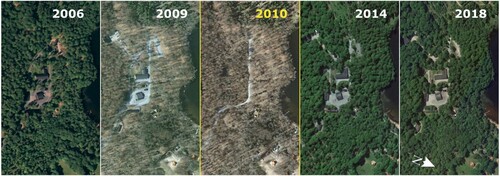
Fake data is not a new challenge for DE. In the past, aerial photos were manually modified to make military installation hidden, and the same happened later with digital photos and digital images. shows a series of historical images in Google Earth. The image taken in 2010 is inconsistent with the previous and subsequent images; has been modified and some buildings are no longer visible (Ogleearth Citation2011).
Figure 2. Historical images available in Google Earth with respective dates of acquisition.
What is new today is the greatest ease in editing data and the increasing number of fake data editors. The above example on COVID-19 and similar cases are of relevance for the future of DE (Simpson Citation2021). Self-regulatory standards for DE platform providers are needed if we want the users to trust on the data they use.
4.4.4. Ethics of artificial intelligence systems
AI instruments and models have dramatically pushed users’ proliferation. These technologies influence what information people see online by predicting what content is interesting to them. Furthermore, AI systems can capture and analyse data from cameras, personalize maps, routes, and advertisements; AI is also used for developing the so-called personal healthcare. In other words, AI affects many parts of human life on this planet. For these reasons, there is a need to ensure that AI is human-centric and trustworthy.
Governments, advisory bodies, and even private companies are coming up with sets of guidelines on the ethical use of AI. While there is a great heterogeneity in the values and principles they uphold, in general they focus on promoting: transparency, justice, non-maleficence, responsibility, accountability and privacy, safety, and trust (Jobin, Ienca, and Vayena Citation2019; Vesnic-Alujevic, Nascimento, and Pólvora Citation2020). For example, the most prominent guideline is the UNESCO Recommendation on the Ethics of Artificial Intelligence (Citation2021) in which it promotes the following principles: (a) proportionality and Do No Harm, (b) safety and security, (c) fairness and non-discrimination, (d) sustainability, (e) right to privacy and data protection, (f) human oversight and determination, (g) transparency and explainability, (h) responsibility and accountability, (i) awareness and literacy, (l) multi-stakeholder, and adaptive governance and collaboration.
In the near future, there are likely to be more regulations and standards enforcing such principles. In April 2021, the European Commission submitted its proposal for a EU regulatory framework on AI. The Artificial Intelligence Act (EC Citation2021) represents the first attempt globally to horizontally regulate AI. Principles and best practices are other examples of valuable artefacts such as: the ‘Good Practice Principles for Data Ethics in the Public Sector’ by OECD (OECD Citation2020) and ‘Peace, Love & DataEthics’ (Dataethics Citation2019).
5. Perspectives and way forward
5.1. Innovation perspectives
5.1.1. 6g revolution and the (global) satellite internet constellations
6G (the next-generation mobile technology) will be orders of magnitude faster than its predecessor and a key enabler of IoT 2.0 and the edge computing paradigm. 6G technology promises to enable a pervasive and seamless IoT that not only connects people’s devices to the network, but allows sensors, vehicles, and many other products and technologies to communicate with each other seamlessly and reliably – a significant leap forward in terms of latency time and the amount of data transmitted per second. For example, proponents argue that having vehicles that can not only communicate with the cloud, but also which each other will result in more efficient traffic and safer travel.
One ongoing technological development is the (global) satellite internet constellations – for example, by Starlink, OneWeb, Project Kuiper, Hongwan, and Sfera. Satellite internet constellations refer to a new generation of very large constellations (aka mega constellations), which orbit in low Earth orbit (LEO) to provide low-latency, high bandwidth (broadband) internet service. These innovative infrastructures promise to provide 5G/6G connectivity (virtually) anywhere on the planet. For continental distances, LEO satellite internet networks should be able to provide lower latency than optical fibre links (Handley Citation2018). 5G/6G and these satellite infrastructures appear to be the key components of the nervous system that will characterize a cyber-physical society – where (ultra-high bandwidth) connectivity is everywhere and anytime. The number of possible applications (at the global/regional/local scale), enabled by these infrastructures, is almost infinite and affects all human and natural domains.
5.1.2. An innovative engineering paradigm for DE: datafication
As introduced above, the current and forthcoming digital transformation of society has led to the emergence of a new paradigm sometimes known as datafication (Mayer-Schönberger and Cukier Citation2014). According to this paradigm, all aspects of our life are converted into quantified data, which can be analysed to generate actionable intelligence. When a user interacts with DE the large volume of data available now require a new paradigm for processing and extracting knowledge. DE must embrace the datafication paradigm because it fits beautifully with its vision and supports the expected services. In the DE application domain, the datafication model should largely be based on three digital processes (Nativi, Mazzetti, and Craglia Citation2021; Guo et al. Citation2020):
(Big) Data collection: the collection, aggregation, and contextualization of digital artefacts and digital footprints constantly generated by humans, machines, and real objects connected to the network. The next generations of IoT (IoT 2.0), social sensing platforms, remote sensing instruments, and global communications broadband systems will further increase the volume, diversity, and speed for which we can talk about big data.
Generation of deep insights: the recognition of valuable insights by analysing the collected big data. This is commonly achieved by using big data analytics techniques, i.e. advanced (visual) analytic techniques against very large and diverse big data sets that include structured, semi-structured, and unstructured data from different sources and at different sizes in the order of terabytes/zettabytes. Today, these practices make largely use of advanced data management systems and data-driven AI technologies. Scientific methods in remote sensing are changing because of their impact to generate insights. In the near future, to respond to the evolution and increase in the challenges posed by Big Data, an ever greater analytical capacity with ever shorter response times will be required.
Interpretation of insights and actionable intelligence generation: the interpretation of the generated insights to develop a profiled intelligence based on user needs. This is achieved through specialized online platforms that interact with users, as well as data analytics and AI stakeholders to provide personalized services. This approach offers a rich user experience by applying the principles of the platform economy. In the next future, application tools and services will work more and more with analytical insights and less with observational data. New systems and approaches will be increasingly needed, for example by applying the Digital Twin paradigm.
Successful adoption of the datafication model requires some cultural, organizational, and industrial changes, including:
Move from the Web-as-a-Network (WaaN) to the Web-as-a-virtual Platform (WaaP) philosophy;
Operate in a cyber-physical world interacting (mainly) at the level of digital platforms;
Adopt the digital ecosystems philosophy (see paragraph 5.2) and its principles (i.e. flexibility, evolvability, viability, autonomy);
Introduce innovative styles of governance (see paragraph 5.3), and
Build trust, addressing challenges dealing with ethics, privacy, transparency and cybersecurity.
Innovative legal regulations and process standards are going to be developed and adopted to address important ethics, transparency, and privacy challenges. In addition to these means, for cybersecurity and data integrity, some innovative technologies promise to provide key instruments –notable examples are block chain and quantum communication services.
5.1.3. The digital twins (r)evolution
The Digital Twin (DT) model and systems have been present in the industrial manufacturing processes for decades. However, it is only with the recent advent of transformative digital technologies and the datafication of society that the DT paradigm has been applied in the geoscience domain (Nativi and Craglia Citation2021a). This model promises to be a great opportunity for DE because it is based on datafication technologies (i.e. IoT, Big Data, and AI) and continuously generates the information and/or actionable intelligence required by DE applications and services.
Several definitions of Digital Twins (DTs) have been proposed (Barricelli, Casiraghi, and Fogli Citation2019), reflecting the different concerns of the industrial, scientific, and standardization sectors, which have worked on their description and implementation. The DT interaction pattern belongs to the cyber-physical domain, where living and non-living entities (i.e. things) have both physical and virtual representation (Nativi et al. Citation2020b). More recently, Nativi and Craglia introduced a Digital Twin of the Earth as
the digital replica of an Earth system component, structure, process, or phenomenon obtained by merging digital modelling (notably, learning based models) and real-world observational continuity, that is, natural and societal sensing data streams. A Digital Twin of the Earth continuously learns and updates itself and must be seen as a living digital simulation model that modifies and changes itself as its physical counterpart changes. (Nativi and Craglia Citation2021b)
By connecting the physical and the virtual worlds, data is seamlessly transmitted from one to another allowing the virtual entity to exist simultaneously and interact with the physical entity. On the other hand, the DT concept permits to decouple the digital replica from its physical entity, making it easier to change it and run fast and safe simulations. By using advanced data-driven analytical procedures, it is possible to generate those insights that could not be carried out using the traditional observation models.
In the DE context, DTs of the Earth aim to effectively simulate and predict the behaviour of key natural and societal systems, processes, or phenomena. This is achieved by processing a huge amount of data (generated and shared daily on the network) by means of the AI technology. DTs of the Earth are advanced tools that allow scientific experts and policy makers to play with a digital replica of important natural and social phenomena and processes. DTs of the Earth make it possible to understand and possibly predict the behaviour of complex systems and phenomena by generating the intelligence necessary to make our society ‘smart’ enough to be more sustainable and implement ambitious policies, such as the UN Sustainable Development Goals (SDGs) agenda and the European Green Deal transition (Nativi and Craglia Citation2021b).
To better understand the challenges in implementing DT of the Earth, it is useful to distinguish the concept of DT from two other notions that are often used with an equal meaning: digital model and digital shadow. The three concepts implement different levels of integration between physical and digital entities (Kritzinger et al. Citation2018). A digital model does not implement any form of automated data exchange between physical and digital entities. In a digital shadow, an automated data stream is realized between the physical and digital state of the entity (i.e. the ‘Data stream’ connector). Meanwhile, a DT has to implement automated data exchange in both directions between physical and digital entities. Instead of distinguishing these three concepts, some experts prefer to talk about more or less automated DT.
The spatial and temporal dimensionalities play an important role in qualifying the possible DTs systems and applications. For example, smart cities (or City Twins) can be seen as a DT whose spatial boundaries are constrained by given city borders – alternatively, they can be seen as the aggregation of citizens Personal Digital Twins (see Nativi, Craglia, and Sciullo Citation2022). This highlights how the DT paradigm allows integration between spatial, social, and even personal phenomena.
To fully embrace the DTs of the Earth (r)evolution, DE should address important scientific and modelling challenges, including:
model the different levels of granularity of the DTs and their possible composability;
unify (existing) data and scientific model standards;
effectively share data and scientific models;
introduce innovative web-based services (notably, behaviour-based);
introduce specific standards for DT reference frameworks, clearly distinguishing between ‘digital model’, ‘digital shadow’, and ‘digital twin’;
implement effective multi-cloud platform operability; and
establish forums for sharing views and knowledge about DTs of the Earth.
5.1.4. Gaming technologies
The geospatial industry has reached a high level of maturity. What is still missing is to systematically support a massive participatory process providing suitable tools and methodologies. Instead, this is a characteristic of the gaming industry that develops online games with millions of users connected. Gaming technology is only partially used by the geospatial industry (notably for visualization and user interaction), but what is missing is a technological framework that allows all the users to play an active role simultaneously. Nowadays, the gaming industry is the main driver for advancing human–computer interfaces and developing virtual reality and immersive experiences.
The gaming industry reaches 1 in 3 people on the planet and has a platform with unprecedented influence (UNEP Citation2022). This industry can contribute to DE by supporting initiatives that aim to raise interest and awareness on our planet preservation and by developing technologies, infrastructure, and social data streams that can be beneficial for DE.
A significant example is represented by the ‘Playing for the Panet’ Alliance. The UN Environmental Programme (UNEP) has partnered with the gaming industry to explore how, through their massive reach, they can inspire young people to learn and act in support of the environment.
The Playing for the Planet AllianceFootnote11 was launched on 23 September 2019. Its members (who can reach more than 1 billion video game players) have made commitments ranging from integrating green activations into games, reducing their emissions and supporting the global environmental agenda.
A relevant example for DE is how the attitude of people towards sustainable development can be changed through specific games. The Alliance’s project Green Game Jam started in 2020 as a competition between game studios looking to add meaningful actions into their existing games to combat climate change to add meaningful action to existing games to fight climate change. During the Jam, mobile and console studios from around the world embark on a journey to capture the imagination and attention of their players through new content in the form of ‘green activations’, or in-game climatic actions, around a specific climate change theme. This Jam has influenced studios to explore how environmental themes can be integrated into traditional games in a way never seen before (UNEP Citation2022).
An example of the second opportunity is the company Blackshark.ai.Footnote12 Their AI-driven technology enabled Microsoft’s Flight Simulator to display the surface of the entire planet in 3D (with over 1.5 billion photorealistic buildings). Blackshark.AI applies AI intelligence onto 2D satellite and aerial imagery to derive semantic object classification information and metadata to create a blueprint of the world that is then automatically transformed into photorealistic 3D. The Blackshark.AI environments can be used for all kinds of simulation applications, be it in the context of autonomous driving, humanitarian relief, city planning, or government efforts. On November 2022 the company launched a ‘globe plugin’ making the whole world available in 3d to anyone. The freely available plugin will allow users to generate their own applications in Unreal Engine for any kind of simulation, and visualization projects based on the real world.
5.1.5. Toward the DE Metaverse
A definition reported in Chapter 3 states that ‘DE can be seen as the link between the real and the virtual Earth planet, with the aim of managing society, the environment, and the economy through a better understanding of the global versus local dynamics’. We see here a link to a ‘metaverse’ dedicated to DE where people gather to socialize, discuss, and act.
Many people have misconceptions about the definition of the Metaverse and use the term to describe different things. What is clear is that the metaverse is motivating the novel integration and deployment of diverse technologies for collaborative spatial computing, such as interactive 3D graphics, extended (augmented, mixed, and virtual) reality, photorealistic content authoring, geospatial systems, end-user content tooling, digital twins, real-time collaboration, physical simulation, online economies, multi-user gaming, and more – at new levels of scale and immersiveness.
The Metaverse Standards ForumFootnote13 was launched on June 2022 to bring together leading standards organizations and companies for industry-wide cooperation on interoperability standards, which are needed to build the open metaverse. The Forum wants to explore where the lack of interoperability is holding back metaverse deployment and how the work of Standards Developing Organizations (SDOs) can be coordinated and accelerated. Unsurprisingly, the Forum aims to develop consistent terminology and deployment guidelines while also accelerating the testing and adoption of metaverse standards (Metaverse Standards Forum Citation2022).
For non-expert users, the metaverse is a digital environment generated by a computer that can coincide with extended (virtual, augmented, or mixed) reality, in which they commonly enter through an avatar. The analogies with video games are evident. Of course, from a technological and procedural point of view, a metaverse is much more. According to Matthew Ball (former Amazon Studios strategist and author of the book ‘The Metaverse: And How It Will Revolutionize Everything’), the metaverse is a large-scale, interoperable network of three-dimensional virtual worlds represented in real time, which can be used synchronously and persistently by an unlimited number of people with an individual sense of presence and with continuity of data (Ball Citation2022).
In future we can imagine people organizing a meeting, opening a window on the year 2050 and look at DE and observing the impact of desertification (built upon a Digital Twin or a model simulation showing the evolution since 2020). Then discuss, propose actions to be done now, rerun the models, and re-discuss the impact.
Especially for the DE context, these metaverse traits are essential: (a) three-dimensionality, persistence, synchrony, and the possibility to have an unlimited number of people participating at the same time in the same event and experience a feeling of actual presence in that place and at that moment. Synchronicity means that the metaverse is a virtual world that cannot be turned off and where actions have consequences and interactions between users –they simulate real life and are fluid and without delays.
Several Metaverse observatories were recently established to study the phenomenon, to date, according to one of them, we can count over 40 virtual worlds in which (according to estimates) live about 350 million people. They differ from each other based on: possible three-dimensionality of the environments, need for a dedicated device for access, use or not of a blockchain to encode the internal operation, more work-oriented or game-oriented or commerce-oriented setting, and the difference between virtual and augmented/mixed reality.
An example of a DE pseudo-Metaverse already exists. It is called Earth2.io,Footnote14 a 1:1 scale virtual digital world of the Earth. Places in Earth 2 are essentially in the same location as Earth because the Earth 2 digital grid system is geographically linked to the world we live in. The vision of Earth2 is to create a global digital representation of the planet, a place where people can build, abide, trade, live, experience, interact and so much more. The vision is long-term and monumental (although the platform functionalities are very limited) and the authors feel the introduction of Earth2 represents the birth of the world’s virtual timeline. In our opinion, Earth2 is at the moment a market place for a virtual economy where you can purchase or sell pieces of land (including their own property). However, the existing Earth2 infrastructure already includes some of the components that are needed to build a digital replica of the Earth, assess the impact of environmental models, and allow interaction between users and decision-makers.
To make DE more relevant, we believe that similar platforms might be needed for scientists to engage with younger generations, the public and decision-makers, e.g. showing the socio-economic-environmental impact of more informed decisions (taken on the basis of sound scientific models, effective simulations, and real-time qualified data). This would address the demand for a collaborative laboratory as envisaged in Gore’s (Citation1998) vision.
Due to the complexity of investigating all environmental and social challenges, it may happen that in the next future more metaverses will be created to address some of the grand challenges (e.g. fight against climate changes, disaster responsiveness, and resilience, etc.). Such metaverses should leverage all the innovative technologies (described in the previous chapters) and act as an integrated platform that is governed in line with the previously highlighted ethical principles.
5.2. Integration perspectives
5.2.1. From spatial data infrastructures to the digital ecosystem paradigm
For data sharing and interoperability across the Internet, the traditional paradigm commonly relies on search and discover services. Typically, the model pattern is to find the data first, then download and use it locally. As a result, digital data infrastructures have been designed and developed to apply this interoperability paradigm such as, for example, the INSPIRE and GSDI Spatial Data Infrastructures (SDI). This interoperability paradigm has had important merits in promoting the formalization of metadata and the standardization of data encoding. However, it has also demonstrated its limits in solving semantics, pragmatic, and contextual interoperability – see for example analysis-ready-data problems and solid data re-usability. Finally, non-technical interoperability issues, such as the diversity of data policies, degree of openness, ownership, and fitness for purpose, have hindered the widespread use of this approach (Nativi, Mazzetti, and Craglia Citation2021).
Digital transformation has shifted economic, industrial, and social relations into the cyber-physical world (known as ‘phygital’, also containing conceptual links to mixed reality). In this cyber-physical world, all relevant stakeholders are included more easily than in the pure physical world. They can cooperate more closely to generate the knowledge needed to tackle complex goals. To facilitate this, the ‘cyber-physical’ environment provides the necessary scalable analytics and interpretation tools and services enabled by virtualization technologies such as cloud platforms and infrastructures (Nativi, Mazzetti, and Craglia Citation2021). As a result, it is possible to go beyond the data exchange interoperability paradigm and address most of its shortcomings. Interoperability moves from the level of sharing observed data to sharing the information and knowledge generated by those data analytics.
The volume and heterogeneity of data produced daily by a digitally transformed society are too great for stakeholders to process and analyse it locally, effectively, and sustainably. Therefore, policy, industrial, and economic organizations no longer find the SDI discovery & access paradigm particularly useful. The cyber-physical world is called to aggregate, harmonize, and analyse big data to generate insights and knowledge (Nativi, Mazzetti, and Craglia Citation2021; Liu et al. Citation2022). There is no longer any distinction between the local digital environment and the network, because most organizations store and process the data on the network itself. Search, access, and data processing (increasingly) rely on machine-to-machine interactions and interfaces.
The digital ecosystem model seems to fit particularly well with the ever-changing nature and needs of the cyber-physical, where heterogeneous stakeholders can decide to cooperate from time to time and on a use case base. Nativi and Mazzetti introduced the concept of geosciences digital ecosystem as ‘a digital ecosystem whose functional utility is the generation and sharing of knowledge on the Earth’ (Nativi and Mazzetti Citation2021). A geosciences digital ecosystem is a system of systems that applies the digital ecosystem paradigm to model the complex collaborative and competitive social domain dealing with the generation of knowledge on the Earth. The geoscience digital ecosystem approach is particularly suitable to implement the DE vision, leveraging the digital transformation enabling technologies, and addressing the social, governance, ethical, and industrial concerns. Derived from the natural ecosystem concept (Blew Citation1996), the digital ecosystem paradigm focuses on a holistic view of a diversity of autonomous organizations, sharing a common digital environment and set of digital assets to survive, thrive, and coevolve. Digital ecosystems, like their digital counterparts, aim to emulate the self-organizing properties of biological ecosystems, which are robust and scalable architectures capable of automatically solving complex and dynamic problems (Briscoe and De Wilde Citation2006). As is the case with natural ecosystems, digital geoscience ecosystems are subject to internal and external disruptive changes that threaten their effectiveness in delivering the ecosystem services society requires. For this reason, geospatial digital ecosystems need governance that ensures care and protection (Nativi and Mazzetti Citation2021).
5.2.2. Digital governance
Governance played a significant role in the Goodchild et al. vision paper (Goodchild et al. Citation2012): ‘Any effort to develop a next-generation Digital Earth will require new governance models’. No specific efforts have been made since then, but the challenges related to digital governance are increasing and intensively discussed both from a regulatory, technological, and organizational point of view. What is still missing for the effective implementations of DE is a collaborative framework allowing government, industry, academia, and citizens to jointly contribute to this DE goal. However, current attempts to govern digital transformation will be certainly beneficial for DE implementation. As already anticipated, governance plays a key role in establishing, operating, and evolving a successful digital ecosystem for DE. Among the various aspects related to Digital governance, we discuss here some particularly relevant for DE: data governance, AI ethics, system of system governance, regulations, and standardization.
5.2.3. Data governance and AI ethics
The influence of AI has had a profound impact on DE, and AI ethics guidelines are proliferating. While these guidelines and regulations are not developed specifically for DE applications, the use of AI for DE implies that we must ensure that the methods used for data collection, data processing, data storage, and data visualization adhere to these processes.
For example, trust is a fundamental requirement for DE. Due to the black box nature of AI, the two aspects of efficiency and trust conflict. Research activities on explicable AI (XAI) and on algorithm transparency will be of particular relevance for DE. The new European Centre for Algorithmic TransparencyFootnote15 and the measures adopted under the Digital Services Act (EC Citation2022b) will play a key role in pooling research efforts and providing scientific evidence for future regulations and standards.
On the other hand, despite the proliferation of AI ethics guidelines, there is a considerable lack in the availability of methods and knowledge on how to implement and audit them (Morley et al. Citation2020; Gevaert et al. Citation2021).
To some degree, DE systems may follow implementation and auditing tools developed for other types of data. However, DE also has unique characteristics that will require the development of specific tools. For example, due to their spatial nature, DE systems allow for multiple sources of information to be overlaid which can lead to unintended use of the datasets. Secondly, through the use of remote sensing and other data collection techniques collected at a distance, a distance is created between the manipulator or user of the data versus the data subject.
Although nations all over the world accept key AI ethics principles and guidelines, as represented in the UNESCO Recommendations, the trade-offs and nuanced understanding of these principles will vary across local contexts. This leads to another key challenge for AI ethics applied to DE: DE data is global by nature, while the framing and balancing of ethical priorities differ across local contexts (Micheli et al. Citation2022). Designing the toolsets needed to ensure the implementation of AI ethics guidelines in DE requires close collaboration between technical experts (with knowledge of data collection and manipulation processes in remote sensing, GIS, and data science) with social experts (with knowledge of human understanding, ethics philosophy, and legislation) and stakeholders familiar with the local context (Gevaert Citation2022).
DE highlights the tension between collection of data and setting ethical values on a global scale versus local values and applications. Thus, DE provides a valuable perspective to the broader AI ethics debates regarding the importance of incorporating local values. DE applications should consider ongoing discussions and practical attempts to address power asymmetries in data governance. Access, control, and use of data by a wide range of actors, including less powerful ones such as citizens and civil society, is a prerequisite for a citizen-centric and ethical approach to data. Such ethical approach enables the production of public value through data and could give significant direction to the development of DE. Data governance and AI ethics are inextricably linked and must be addressed together.
Good practices regarding AI ethics and data governance for DE applications and geospatial data in particular should be collected and shared to facilitate their implementation and dissemination. Education and awareness on data governance, AI ethics, and digital transformation challenges are also crucial at all levels, from local to global, in governments, industry, scientific community, and civil society. The field of DE should establish links with the wider debate on AI ethics and data governance, for example by maintaining a dialogue and building bridges with other disciplines.
5.2.4. System-of-systems digital governance
Policymakers around the world are aware of the importance that digital technologies have on their countries’ strategic autonomy and a global race for technological leadership has developed. On the other hand, the DE vision is global by its nature and must pursue an open and fair interoperability among the many existing and future digital resources needed to model DE. Strengthening the role of citizens and creating more inclusive data governance structures are key to this end.
For these reasons, there is a need to envision and promote innovative collaborative governance styles that ensure: public value, data sovereignty, and inclusivity (Mulder et al. Citation2016; Taylor Citation2017; Micheli et al. Citation2020; Micheli et al. Citation2022). Public value implies ensuring that the value of data is not limited to governments and companies but rather redistributed among various stakeholders in society (i.e. public value). Data sovereignty implies providing individuals and organizations the ability to exert authority over their data. Finally, inclusivity implies ensuring the inclusion of marginalized or less powerful actors so that they can also share the benefits derived from (their) data. The value of such collaborative governance styles is particularly emphasized during emergencies and natural disasters (Mulder et al. Citation2016). Take for example cases where citizens have contributed local knowledge of business opening hours, take-away options, and other COVID-19 response measures to the Open Street Map open geospatial platform (Minghini, Sarretta, and Napolitano Citation2022) or the use of mobile device data to track the spread of COVID-19 and citizen mobility during the pandemic (Vespe et al. Citation2021; Simpson Citation2021).
Implementing collaborative governance styles for DE will also face challenges, which indeed resonate with those related to implementing AI ethics. Collaborative and inclusive governance structures will require a careful balancing of perspectives between stakeholders (Micheli et al. Citation2022). These may include conflicts between top-down data collection organizations and bottom-up citizen-led initiatives, as well as local groups with conflicting interests. Particularly for DE applications, it will be difficult to balance the global nature of DE (which implies global standards) versus local needs. Yet the value of collaborative governance structures is clear and strategies are emerging to address the implementation challenges; the coming years will likely show many developments and best practices in this field.
5.2.5. Legal regulations and technological standards
As above earlier, digital governance is a key factor in designing, implementing, and operating a successful infrastructure or platform. For example, a geoscience digital ecosystem is enabled by at least three contextual conditions under which ecosystem actors operate and which motivate, direct, and constrain their actions as providers, intermediaries, and consumers (Cavanillas, Curry, and Wahlster Citation2016; Scott Citation2013; Janssen, Charalabidis, and Zuiderwijk Citation2012; Nativi, Mazzetti, and Craglia Citation2021):
Regulatory conditions (laws, policies, standards, and agreements) that affect how ecosystem components are structured and how they interrelate.
Institutional/organizational conditions in which the actors operate; each organizational and/or institutional context provides a set of shared social and cultural values, which influence the actors operating within that particular context (Scott Citation2013). These values inevitably push and limit the behaviours of actors in the ecosystem (Janssen, Charalabidis, and Zuiderwijk Citation2012).
ICT capabilities conditions: computational, data storing, analytical software, and network elements, along with the communications protocols that interconnect these elements with the network operators and users (Cavanillas, Curry, and Wahlster Citation2016). In this context, for example, the main capabilities are cloud computing and HPC, AI analytical software, the Internet, and the Web. They are all key enabling technologies that respectively introduce new players into the ecosystem.
Governance implementation tools include: laws, regulations, regional/international standards, software engineering tools, and best practices (including community of practice specifications and metrics). For example, recently, the European Commission has proposed a number of regulations dealing with AI risk systems, data services, and data access and re-use (e.g. AI act, Data Service act, Data Governance act, and Data act).
The primary objective of standardization is the definition of technical or quality specifications with which current or future products, production processes, or services may comply. Standardization can cover various issues, such as standardization of different grades or dimensions of a particular product or technical specifications in product or service markets where compatibility and interoperability with other products or systems are essential (European Union Citation2012). In many countries, legislators put standardization at the hearth of digital and industrial strategy; for example, in Europe, standards play a special role in helping to make the single market a reality. Standards help protecting people and the environment and empower the digital transformation, stimulating market development, increasing the international competitiveness, and supporting regulations. An International Standard (IS) can take many forms; in addition to product standards, other examples include: test methods, codes of practice, guidelines, and systems management standards (International Standards Organization Citation2021).
The DE Community should be engaged and contribute to the relevant (international and regional) initiatives and projects aiming at defining regulations and standards dealing with the digital processes/platforms form modelling, simulating, and predicting the Earth system, its subsystems, and components.
5.3. Inclusivity perspectives
5.3.1. Citizen engagement and gamification
In previous paragraphs we have discussed the value and challenges related to citizen science and crowdsourcing, we have seen the power of immersive technologies in allowing users to explore and interact, and we have noted the possibility of collecting billions of data in real time through digital sensors and devices. Let us now consider the issues of an operational system based on citizen engagement through gamification.
Gamification is the process of using game mechanics, elements, and principles and applying them to non-game contexts to better engage users. The purpose of gamification is to motivate and inspire users to engage with the content, especially with activities that aren’t fun or repetitive: ‘People are drawn to participate because some psychological, social, or emotional need is being met. And when the need isn’t met, they don’t participate’ (Howe Citation2009).
Van Ransbeeck (Citation2016) distinguishes between intrinsic and extrinsic motivation. He gave examples of intrinsic motivation such as
creative fulfilment, a belief in the project or even the sense of community obligation. As a consequence, intrinsic rewards are in the order of autonomy or the degree of freedom and creativity allowed by a task, being part of a community, learning during the process and any form of altruism.
Whereas intrinsic motivation works well in some applications, extrinsic motivation may work better in others.
Monetary rewards, gains in reputation and social recognition are good examples of extrinsic motivations. In other words, gamification – i.e. the application of game-design elements and game principles in non-game contexts such as citizen participation platforms – is a mechanism that triggers extrinsic considerations with the citizen. Offering extrinsic rewards and a sense of fun to crowdsourcing ideas from citizens can be an excellent approach to increase engagement. (Van Ransbeeck Citation2016)
Examples of game mechanics used in gamification are: (a) Goals and Rewards – users are motivated to complete the task and get a reward, such as a badge or points; (b) Status– - users increase their level or rank through completing activities. Leaderboards show who is ‘winning’ and inspire users to work harder to compete; (c) Community – users are paired or put in groups to solve problems, complete activities, or otherwise achieve an objective; (d) Education – users are provided with tips, tricks, and quizzes, throughout the process. These fuel users’ motivation and keeps engagement high (Strobl et al. Citation2019).
Successful gamification will tap into the user’s intrinsic motivation. Gamification will be beneficial to citizen science and crowdsourcing contribution to DE. DE research community should more closely collaborate with the gaming industry to explore the value of gamification as demonstrated by the success of the Playing for the Planet initiative described in chapter 5.1.4.
5.3.2. Industry engagement
A key success factor for the future of DE is the involvement of industry in engaging key stakeholders in academia, government, public and private sector, and youth. As described earlier, reflecting on the role of citizen engagement and gamification, the industry offers exciting perspectives and opportunities to harness the power of doing environmental and social good through gaming, underpinning the design, and operation of critical infrastructure for resilient cities of the future. This includes professional communities of practice and forums that bring these communities of practice together.
There are already emerging precedents of professional organizations incentivizing and encouraging industry engagement in geospatial thought-leadership. A world-leading example of coordinated industry engagement is the World Geospatial Industry Council (WGIC), a registered not-for-profit trade association of commercial geospatial companies covering the entire value-chain of the geospatial ecosystem. Launched in 2018, WGIC has already produced nine global-outlook public and industry reports that highlight innovations, capabilities, and benefits of DE, through policy development and advocacy, partnerships and industry engagement, public–private partnerships, and industry and academia collaboration (Chauhan Citation2022).
There are also precedents of forums that engage industry in imagining future possibilities and initiate thought leadership dialogue on matters of industry relevance and global consequence. This includes for example the Geospatial World Forum annual conference, which aims to demonstrate the ‘collective and shared vision of the global geospatial community’. It now also includes the annual United Nations (UN) World Geospatial Information Congress. Reflecting on the 2022 conference in Hyderabad (India), the role of industry is essential to ‘geo-enable the global village’ across several priorities going forward, to enable linked national infrastructure, metaverse collaboration, and digital infrastructure resilience in the face of disasters.Footnote16
Broad industry engagement in DE must be fostered, to implement the recommendations and calls to action by the United Nations Global Geospatial Information Management (UN-GGIM), to build and strengthen national spatial data infrastructures (SDI) of member states. There is an urgent priority for industry intelligence to support linking national datasets into a globally accessible platform for a truly global approach. Considering the substantial global reach of multinational corporations, there is an unprecedented opportunity for industry to lead through connecting spatial datasets around commodities and services, which then create global datasets for stewardship in environmental and social matters.
Deep industry engagement in DE should be encouraged, to accelerate the design and planning for metaverse experiences. Alongside the emerging real global datasets regarding essential services, commodities, and supply chains, the metaverse provides unprecedented opportunities to engage in virtual activities that can be simulated and then realized in the ‘real world’. Considering the multi-faceted data relationships across the built environment sector, financial sector, and health sector globally, metaverse enablement of real-to-digital world relationships may help to accelerate the achievement of environmental and social outcomes that have not been possible to date.
Genuine industry engagement in DE must be enabled, to address the urgent reality of critical digital infrastructure resilience, such as servers, data centres, and transmission networks. In the face of increasing adversity associated with climate change impacts, and in addition to challenges in some parts of the world associated with resource scarcity and dynamic geopolitics, it is essential that the UN vision of ‘no one should be left behind’ is upheld during disasters and catastrophes. This includes advancing ‘blue sky’ planning for disasters, creating local contingency plans for industry, government, and community in case of temporary or sustained drop-out of digital infrastructure, which is responsible for so many essential services such as water supply, treatment, power, food storage, and financial processing facilities.
In addressing these three priorities, industry engagement for capacity building for the current and next generation of workforce is also critical. There are some emergent examples of industry and academic collaborations in accelerating workforce digital enablement. For example, Bentley Software, Autodesk, and ESRI all have open-source online engagement programmes for all ages, encouraging creativity and skill-building in mapping, design, and visualization. This industry-led collaboration with universities is empowering the next generation of young entrepreneurs, emerging leaders, and planetary stewards.
5.3.3. Education and capacity building
DE is a valuable framework for and approach to education: it is not considered the traditional turf of established disciplines starting with ‘Geo’, addressing the full scope of digital transformation while still focusing on the geospatial range of scales through Earth. A transdisciplinary perspective on resources, society, environment, and the economy under a digital paradigm is considered mandatory for today’s needs, without the baggage sometimes associated with or mandated by the original home disciplines of geospatial concepts and methods.
DE is mainly composed of the deep integration of new-generation information concepts, methods, and technologies, such as Big Data, Cloud Computing, Remote Sensing, Positioning, and Navigation, Geographic Information Systems, and geospatial media-based communication including, e.g. virtual reality technology. DE education facilitates students’ competences with knowledge and skills to locate, measure, and solve problems that happen in our world. An early operational focus of DE education was the founding of a European initiative in November 2011 intending to support teachers in different parts of Europe and connect people working in national and regional contexts (Jekel et al. Citation2011). With related technological advances, DE is now much closer to reality by utilizing vast amounts of information and is gradually becoming a significant force to reform education across curricula and subjects. For example, students have used DE technologies to design a high-speed railway (France), map invasive flora (Canada), and identify locations for street lights to enhance public safety (Japan) (Kerski, Demirci, and Milson Citation2013).
Recently, DE is considered a ‘macroscope’ approach (Strobl Citation2017) enabling students to look beyond physical viewsheds and horizons. It therefore enables the perception of phenomena difficult to communicate to young students. Macroscopic geospatial media like maps and imagery stimulate spatial imagination through access to worldwide observations, transformed into information by analyses and contextualized knowledge in support of decisions.
Perhaps more importantly, DE in general (secondary) education offers a highly suitable framework for citizenship education. Public participation is a key foundation for democracy, participation is grounded in the individual experience of residential environments and action spaces. Learning and understanding from, and communicating through, digital geospatial media are indispensable preconditions for participating in societal and political decisions as citizens.
At primary schools, there are some video games (e.g. The Green Game Jam) (UNEP Citation2022) that were born of the cooperation between the UN Environmental Programme (UNEP) and the game industry and that can help teachers to improve students’ interest in learning. Taking the climate change course as an example, the development of game technologies (e.g. virtual reality) can provide immersive experiences for students and form correct cognition toward climate change. Applying the different DE platforms to youth education can develop students’ ability to use digital technologies and then help them better cope with challenges (e.g. environmental, social, and economic) (Cole et al. Citation2001) in the future so that the younger generation can contribute their strength to closing the gap of digital divides.
At universities, DE programmes evolve from and beyond traditional study programmes. The European ‘Copernicus Master in Digital Earth’Footnote17 is an example of this kind of next-generation programme. An increasing number of professionally oriented programmes are taught online (Strobl Citation2011), offering access to in-service professionals in a continuing education context, thus making an important contribution to the capacity building for the workforce in a growing industry.
On the other hand, introductory-level Geoinformatics courses are infused into a broad range of academic curricula. This spatial enabling of very different study programmes demonstrates the transdisciplinary potential and importance of a spatial perspective and the power of ‘connecting spatially’ between otherwise independent observations (=data).
The application of DE has changed the content and teaching form of traditional geographic (and other domains) education and has created a novel teaching mode – sometimes referred to as ‘Learning with GIS’. DE concepts and technologies demonstrate great promise and growth potential in education. How to better and broadly infuse DE into education will be the focus of future work. In this context, some significant measures need to be adopted by actors in education to fully leverage the potential of DE in education in the future (Strobl Citation2018).
Increasing the investment (e.g. funding and time) for DE education. For example, the technologies and online access facilities of DE need to be enabled in disadvantaged areas on the wrong side of a digital divide (Strobl Citation2019). Most importantly, teacher training is considered of prime significance in all kinds of regions.
Making educational standards and credentials (at the global, regional, local scale) more unified and advanced in teaching and technology will further promote the use of DE in education. This includes teaching at all levels and in different disciplines, and a possible development of micro credentials.
Promoting the research of DE education in concepts and methodologies, included online and blended modes, will be beneficial to the reform of teaching and then help people understand the geospatial perspective, developing a spatial view of the life and livelihoods.
Promoting the integration and sharing of DE related knowledge resources (e.g. open geodata, analytical methods, transcendental knowledge). For example, an international platform for storing or referencing the teaching and learning resources for DE education needs to be built to ensure that education is consistent with the up-to-date research.
5.3.4. Young generation and digital divide
No other fraction of society is more eager to learn and explore the evolving digital landscape than the young generation. With digitalization growing and evolving in an unprecedented pace due to the advancement of technologies and significant breakthroughs, the youth play a huge role in the development of DE, and they are key elements of this vision (Bandrova and Konecny Citation2014). The youth is a crucial element because they ensure the continuity of research. To continue the efforts that have led to the current DE results, we need to facilitate the inclusion of younger generation in them.
There are still important research gaps on how the young generation can help taking the DE concept further. We don’t have a clear picture of what they understand DE will do for them and the planet in the future. Responding to this gap, within the ISDE programme, the organization’s youth forum was first launched during the 12th International Symposium on Digital Earth (ISDE Youth Summit 2021Footnote18), followed by another Youth Forum at the 9th DE Summit ‘Digital Earth to Bridge Digital Divide for Attainment of Sustainable Development Goals’ (ISDE Youth Summit 2022Footnote19).
It is indisputable (nor is it disputed) that the youth will play a crucial role in various DE platforms. This is also in line with the UN sustainable development goals, which take into account the needs of future generations. Today’s youth will have to bear the responsibility of facing various environmental, social, and economic problems that have been created in the last century (Cole et al. Citation2001). It is essential to ensure that knowledge and training are integrated to develop their capacity to deal with these challenges.
In terms of the economy and the competitive labour market, and in relation to the challenges mentioned above, there is a need for a near-future workforce that has sufficient set of skills and experiences to meet DE challenges. Therefore, it is not only self-evident that the youth will be included in the DE agenda, but also some implementation strategies and goals need to be discussed with them.
As there is lack of resource and research on the role of the young generation directly in relation to the DE concept, we now discuss this issue around the information and communications technology subjects that are central to DE.
According to the UN, the international and universally agreed definition of the youth age group has not been specifically set. For purposes related to research and statistics, the UN, through their Definition of Youth report, has defined youth as those between the ages of 15 and 24. This specific age bracket easily assigns secondary and tertiary students as youth. By this definition, young people constitute 16% of the world’s population. This equates to 1.2 billion and by 2030, the number is projected to grow to nearly 1.3 billion, a 7% increase on today’s statistic (United Nations reportFootnote20). Yet, in the same report, the UN also acknowledges that its definition changes with circumstances, including changes in demographic, financial, economic, and socio-cultural settings. In several entities and organizations summarized by the UN report, such as the UN Habitat, they recognize people aged 15–32 as youth, while the African Youth Chapter has set the age range between 15 and 35 years.
In today’s global scenario, it is necessary to provide another extensive definition to the term, young generation. A huge part of the international workforce is made up of young professionals who, if defined, are not fixed in age.
The term, young professionals is often used in a broad sense hence, so its meaning may vary according to the bodies that define them. In the various UN agencies, through their Young Professionals Programme,Footnote21 young professionals are defined as those who are under 32 or 35 years of age and have a first-level university degree with relevant work experience. This addition to the young sector creates a robust outlook in the development of DE agenda.
The International Telecommunication Union (ITU) defined the term, digital native, as those they defined as youth between 15 and 24 years of age with five or more years of experience using the Internet. ITU found that the youth are nearly twice as much more networked than the global population as a whole, and in the least developed countries, the young are nearly three times more likely to use the Internet than the general population. Access to information and communication technology has given the youth a voice, mobilized this growing global sector, and encouraged them to collaborate across various online platforms.
Including young professionals, today’s digital natives are growing in number higher than the projected estimate given by the ITU in 2013. The ITU stated in their report that 30% of the youth population are digital natives, and within the next 5 years, this population would double (ITU Citation2013). In a more recent report, the number rose to 71% making the youth the most connected generation compared to 57% of the other age groups (ITU Citation2021). This meant that young people were 1.24 times more likely connected online than the rest of the world.
Looking closer, 99% of the young population in developed countries is already online while 67% of the young population in developing countries is on the Internet. This large uptake among the youth means that this population sector has the capability and access to digital information, and moving towards the DE agenda, the world has a future set of individuals that have the digital ability and capability to contribute and implement different DE applications.
With growing (and better) Internet access, the potential to enhance secondary and tertiary school curricula (introducing applications of geoscience, geoinformatics, remote sensing, earth observation, and satellite technology), and a plethora of freely accessible data provided by various institutions, a lot of the young generation will find themselves discovering the applications of these technologies and the data they provide and some, will direct their career towards these fields.
With the rise of earth observation satellites providing wealth of data, and continuous development of technologies supporting the DE platforms, there is no doubt that the job market for this field will increase over time in the coming years. For example, the European Union’s Copernicus programme aims to maximize socio-economic benefits and promote inclusive growth in EO applications and services by supporting start-ups from business ideas creation to full commercialization. Such a model can improve the economic landscape for EO if followed globally. This provides a good outlook for a strong ad prominent workforce for the future DE generation.
In addition to young professionals working in this field, the Internet also offers the public the opportunity to be part of the technical and cultural ecosystems that contribute to the development of DE. For example, citizen science initiatives can guide the young generation in making sure that DE is for all. These provide the groundwork for collaboration, engagement, and public participation even without the in-depth knowledge of DE concepts. While citizen science grows and makes valuable contributions, it is not without its challenges. As to data input, young generation also has issues of quality, equity, inclusion, integrity, governance, and stewardship. These are things that need to be understood and addressed from time to time, and different approaches can be developed to solve these problems and make the next generation of researchers aware of them.
Similarly, despite the global improvement in internet access, the recent ITU report shows that digital divide cannot be ignored; only 40% of school-age children have internet access in their homes, not including stark differences in each country across regions. Furthermore, it is noted in the ITU report that even closing the gap in the digital divide does not guarantee that the young generation can reap the benefits of having this access (ITU Citation2013). In addition to granting access, how people make use of this access is still crucial, and not only economic but also educational and cultural campaigns are needed to address this problem. There are three levels of the digital divide. The first level focuses on access to digital technologies and the Internet, the quality of access, and the digitalization process. The second level includes the digital use gap, skills, motivation, and emotional gap. Lastly, the third level includes the utility gap, offline outcomes and benefits, and the reproduction of inequality (Gómez, Citation2018). Gómez (Citation2018) explored five important barriers within the digital divide: access, skills, motivation, emotions, and utility, which are all distributed in the different levels of digital divide. These barriers affect young people’s use of digital technologies, and asymmetries and barriers can limit the utility that young people can get from the Internet, including sociocultural background and personal processes of technological socialization.
5.3.5. DE as art
There are three well recognized pillars of human culture: science, technology, and art. In this section, we aim to focus on the value of DE as art and the role of art in spreading DE to a wider audience. There is no clear boundary between science, technology, and art. All complex cultural phenomena can manifest simultaneously as art, science, and technology. The great minds of the past – like Leonardo da Vinci – have become famous for their masterpieces in art, as well as their insights in science and inventions in technologies. Architectural marvels – such as the pyramids of Egypt, or modern skyscraper – were not only works of art, but also the implementation of numerous scientific discoveries and technical innovations. The link between science and beauty has also been known for some time (Nadin Citation1991). For example, fractals, derived from mathematical equations, are equally fascinating as works of visual (Peitgen and Richter Citation1986).
The link between science and technology and art is not new even in the geospatial domain. For example, photogrammetry is defined as ‘the science or art of obtaining reliable measurements by means of photography’ (Miller Citation1956) or, as ‘the art, science and technology of obtaining reliable information about physical objects and the environment through processes of recording measuring and interpreting images and patterns of electromagnetic radiant energy and other phenomena’ by the American Society for Photogrammetry and Remote SensingFootnote22 (ASPRS).
DE is the result of the development of humanity’s understanding of our Planet. Mankind’s perception of reality is multifaceted, so it is worth considering DE, not only from a scientific and technological point of view but also from an artistic perspective. It is universally recognized that the development of a DE is the result of the integration of various scientific and technological advances. But if we look at DE from an artistic point of view, we have to answer new questions: what is the aesthetic side of DE? How did art influence the creation of DE? How can DE benefit from artists’ contributions? Could DE itself be considered a masterpiece of art?
Not surprisingly, one of the first precursors of DE, Terravision (developed in 1993), was originally born as an art project by ART + COMFootnote23 (a collective of artists and computer hackers). As the company name (Art plus Communication) makes clear, the aesthetic aspect of modelling the Earth modelling was a crucial element, far exceeding the functional design considerations such as usability. ‘Art of Communication’ and ‘Art as Communication’ are inextricably linked with geospace as a factor that creates the need for communication, therefore the artistic reconstruction of geospace becomes a prerequisite for the formation of new methods and new media of interaction. There were other forerunners belonging to the SIGGRAPHFootnote24 scientific community, which holds well-known computer graphics conferences. Within it is a Digital Commission with the special mission ‘to foster year-round engagement and dialogue within the digital, electronic, computational, and media arts’. SIGGRAPH has inspired developers from all over the world and has contributed to the birth of other similar fora, such as the GraphiCon conferences.
The beauty and diversity of our planet unveiled in the space age have stimulated artistic creativity. Until recently, artists perceived and portrayed only a small fragment of the whole tapestry. It was only with the dawn of the space age six decades ago that the beauty of the Earth as a holistic entity was visible to humanity.
However, DE was envisioned long before Al Gore speech and virtual globes prototypes. For example, the future DE was described in amazing detail in the novel «Master and Margarita» (Bulgakov Citation1940) and centuries ago, Botticelli painted the ‘Chart of Hell’ providing a spatial representation of a transcendent reality in Dante’s Comedy, thus creating one of the first 3D models of the collective unconscious interpreted as a geospatial reality. Today DE itself becomes art, combining the natural beauty of the Earth with the spatial representation of subconscious phenomenon (Monaco et al. Citation2021).
Indeed, DE regards the ‘twinning’ of the geospatial environment not only as precise and measurable technological and scientific achievements, but also as works of art using the latest scientific concepts, advanced technologies, and new stylistic approaches. Such a vision is organically consistent with the concept of situational awareness, which requires ‘the perception of environmental elements and events with respect to time or space’ (Endsley Citation1995). It includes the involvement of a whole variety of technologies (AI, XR, Big Data, etc.) through the prism of an artist’s creativity. Art as a focus in DE thus means exploring the integration of new capture modes, reconstruction approaches, and visual perception into the computer graphics pipeline. Art is also very complimentary to the ethical issues of DE and the phenomenon of perceiving geospatiality as an art object is currently being intensively studied (a growing number of creative groups are exploring it from an artistic point of viewFootnote25).
An interesting example in the field of the artistic reinvention of DE is the book VerticalAtlasFootnote26 that is
a set of tools that enable comparisons, connections, and the seeing of connections and contradictions between different and diverse visions, realities and techno-political worlds – through newly commissioned diagrams, interviews, essays and works of art by leading experts from around the world.
DE should continue to benefit from the contribution of artists and new innovative technologies on human–computer interaction that better support their creativity:
interaction paradigms, moving from universal to content-specific interfaces (e.g. semantic interfaces that are intuitive to use and almost-self explanatory, painting directly in XR);
computational reflective for spatial communication and as an artistic medium;
abandon the screen and communicate using the physical properties of objects and materials;
the capacity sensor technology used in the multi-touch tables, and in amorphous sensitive surfaces;
the superimposition of virtual information over real objects as an effective means of communication (e.g. through augmented and mixed reality implementations);
true immersing borderless experience, like with spherical panoramic video or virtual reality experiences of paintings, theatre, or music.
Social activities and practices also become the art of some kind. Chief among these ‘social arts’ concerns global governance, the true ‘Ars Magna’ of the age to come. DE can transform governance from a social technology into a special and novel kind of art, making it a precise, well harmonized performance or scenic act. Ensuring synergy in decision-making is a fundamental requirement of long-term sustainable development and these requirements could be achieved with the help of DE, for example as an inclusive ‘decision theater’ (Edsall Citation2006). The art of sustainability in the global context of DE is one of the most promising directions for interdisciplinary studies.
5.4. Sustainability perspectives
From a sustainability perspective, the key questions to answer are what is DE and why is needed? The answer can be found by looking back when Gore anticipated the concept of DE in his book ‘Earth in balance’ (Gore Citation1992). The purpose was to inform the public about the dangers of pollution, global warming, and other planetary issues so that people could learn about the problems with the global environment as well as being able to see a vivid overview of the dangers our planet is facing. In the final chapter ‘Striking the Balance’, Gore reveals a proposal that, if implemented correctly and applied, could help reduce the amount of pollution and other negative things, which affect the environment. One of the five major steps involved ‘Developing and sharing technologies’.
Successively Gore’s (Citation1998) used a young girl as the target model. DE should be seen by every child as the gateway to learning and exploring our world. Technology should support children’s portal to a world of hope and sustainability. Therefore, the development of a virtual globe is not and should not be considered the ultimate goal of DE but one of the tools used raise awareness and support Sustainable Development (locally and globally). In this perspective, DE should not be considered so much as a system but as a paradigm – or a general (and technologically-neutral) framework, that is enabled by (and hopefully also contribute to) the digital transformation of society.
Pressures on natural resources are increasing and several challenges must be overcome to meet the needs of a growing population in a period of environmental change. To address sustainability, the 2030 Agenda for Sustainable Development was adopted by the UN in 2015 defining 7 goals, 169 targets, and 232 associated indicators (Metternicht, Mueller, and Lucas Citation2020). Measuring progresses towards these policy goals require timely and reliable access to environmental data and information. From a policy perspective, the SDGs represent a major change since the latest revision of the DE concept and many new digital technologies are spreading globally (e.g. Data Cubes, Analysis Ready Data, AI).
As a result, DE can play an insightful role to provide the necessary basis for reliable and responsible scientific understanding and knowledge to support informed decisions and evidence-based policy advice. It can help to integrate different datasets describing the three dimensions of sustainability to adequately characterize a given location (economic, social, and environmental). DE also allows monitoring and assessing conditions and progresses at different scales (e.g. sub-national, national, regional, global), understanding interactions between various systems (e.g. atmosphere, hydrosphere, biosphere, geosphere), and modelling future changes (Lehmann et al. Citation2020a). Information Technology can play a significant role to leverage modern modelling analytics technologies and generate, in a consistent and standardized way, accountable knowledge demand for decision-makers (Nativi et al. Citation2020).
Currently, considering the widely adopted Driver-Pressure-State-Impact-Response (DPSIR) framework, we are generally able to monitor states and impacts but not drivers and pressures (Pirrone et al. Citation2005). This, in turn, prevents efficient and effective responses from being provided. The digital revolution for sustainable development has been identified as one of the six transformative changes needed to achieve the ambitious objectives of the SDGs (Sachs et al. Citation2019). Metternicht, Mueller, and Lucas (Citation2020) provided a substantial summary of the potential and limitations of DE to support SDGs. DE has the potential to compile indicators in cost-effective and efficient ways, improving the timeliness of information provision and enabling cross-cutting analyses to be facilitated ultimately helping decision-makers in exploring scenarios and identifying possible and relevant policy interventions. However, they also clearly highlighted the lack of coordination to generate the knowledge needed for sustainable development as a key barrier.
There is a clear need to move from data-centric to knowledge-centric approaches (Mazzetti et al. Citation2022). DE can increase collective knowledge to address key current challenges in progressing the UN-SDGs, namely: (1) data sharing tools, platforms, and data governance frameworks; (2) coordination, integration, and mutual agreement among the administration agencies, such as the integration of digital humanities and digital environment; (3) High-dimensional data with balanced time-spatial resolution; (4) Nationally validated data; (5) capacity enablement; and (6) transparency in models and methods.
So far, big data management and the use of AI to extract relevant information can be considered valuable technics used in the field of DE and SDG (Sudmanns et al. Citation2022). For example, Giuliani et al. (Citation2020) used time-series of satellite data together with other geospatial information to generate knowledge and relevant information on the monitoring at various scales of the SDG indicator 5.3.1 on ‘land degradation’. Fukui, Chuc Man, and Phan (Citation2021) showed how DE can act as a platform, together with the concept of ‘Essential Variables’, to contribute to the achievement of various SDGs. The emergence of Digital Earth Africa is empowering African countries and local communities to leverage information from satellite data (with machine learning) and other types of (geo)data to monitor SDGs at different scales across the continent. It also provides access to digital notebooks to process these data linked to various SDG indicators (e.g. 2.4.1, 6.3.2, 6.6.1, 9.1.1) (Digital Earth Africa Citation2022). From a global to a more local scale, DE showed, for example, how to increase stakeholder engagement in Hungary and unlock the use of EO and geospatial data for SDGs, by promoting the use of EO and SDI (and related services) as the building block of DE, supporting SDGs monitoring and reporting (Remetey-Fülöpp et al. Citation2019).
These different studies demonstrate that DE can play a significant role to support SDGs. However, to fully benefit from DE capabilities, they all stress that a strong attention should be paid to the Data-Information-Knowledge-Wisdom pathway for it to be relevant for SDGs implementation (Kavvada et al. Citation2020). Recent advances in information technologies can strengthen the initial DE vision by enabling the execution of complex models that utilize and integrate large volumes of heterogenous datasets. This can help generate collective knowledge and create new opportunities to streamline the dialogue and collaboration between various stakeholders. This can ultimately help to develop scenarios and explore different transformative pathways to identify/understand trajectories to stay in a safe and just operating space (Fukui, Chuc Man, and Phan Citation2021).
The rapid advancement of network and communication technology has also made open and collaborative modelling and simulation possible in cyberspace (Chen et al. Citation2021). Achieving reproducible/replicable knowledge is an essential precondition to build trust in data and information products for decision-makers (Giuliani et al. Citation2019). However, currently the interoperability of data and models is still limited to the syntactic level that allows accessing and processing datasets regardless of their structural characteristics and without explicit reference to their content and context of use (Mazzetti et al. Citation2022). This drastically limits the reusability of scientific practices and related workflows.
Several (recent) concepts may pave the way for enhanced and more reusable knowledge in the DE framework:
Findable-Accessible-Interoperable-Reusable (FAIR) principles (Wilkinson et al. (Citation2016)) are essential for providing access to clean data so that they are more reusable and integrable, and help data from various pipelines to be used across different systems. It can help generate ready-to-use data products (Giuliani et al. Citation2021).
Essential Variable is a holistic concept that can help to better capture the different dimensions of sustainability and effectively describe socio-ecological systems. It can help narrow down the huge amount of heterogenous data and act as a gateway between data and indicators (Lehmann et al. Citation2020b and Citation2022).
Analysis Ready Data (ARD) have already been demonstrated to increase data interoperability, greatly facilitating the integration and analysis of various types of Earth Observations data (Chatenoux et al. Citation2021) and contributing to country-level development policies and practices (Dhu et al. Citation2019).
These concepts are key for bringing socio-economic data together with environmental data, which is an essential pre-condition for realizing the DE vision. To ensure effective support to the SDGs process and framework, it would be beneficial for the UN system to fully embrace the DE concepts, methods, and framework. Having a frontline presence at the UN can help to base all assessments and reports in the form of DE presentations, greatly improving the access to data-information-knowledge about our planet and people.
6. Enabling the DE collaborative laboratory
6.1. DE framework implementation (the lessons learnt)
In 1998, Gore said that, ‘no single organisation can on its own develop all the aspects of DE, it is essential to develop a series of collaborations at the global level to turn the vision outlined in this paper into reality’. However, after the initial push from the US government, there have been no further significant efforts to establish this ‘global partnership’. Soon after the formulation of the DE concept, particular attention was paid to the development of technologies necessary for its implementation. Subsequently, in the absence of specific public funding dedicated to DE, the emphasis has shifted on how to benefit from technological development and how to adapt DE to benefit from the progress made. In the meantime some ethical issues have come up, but not really driven by the DE implementation. Additionally, the impact of the digital transformation of society has raised specific questions about the feasibility and benefits of DE, as originally conceived.
From a systematic point-of-view, a full implementation of DE is difficult due to the complexity of the earth system(s), the wealth of potentially useful information (including sparse or non-existing historical data), the heterogeneous quality of observations/data (across regions), the multidisciplinary skills required for analysis and interpretation and the need for more mature technology (although some solutions are under developments).
While important technological barriers have been addressed in recent decades, non-technological barriers are still present, including cultural, organizational, legal, and industrial ones. There is a substantial lack of specific targets and funding. DE could benefit from a scaling effect that, once implemented, could be used for many different purposes, but the initial investment is difficult to realize. There are too many DE-like activities going on, but none of them brings everyone together towards the common goal of developing a shared DE framework. For example, DE Africa, DE Australia, Euro Data Cube, etc. are significant initiatives developing DE components (i.e. Data Cubes) but are not connected and interoperability with other major DE components is arguable (Nativi, Mazzetti, and Craglia Citation2017).
As argued by the ISDE Bureau and its working groups, another serious limiting factor is the lack of a compelling suite of tools to galvanize and attract citizens and experts to use common platforms, compliant with the DE vision. Furthermore, the value of DE has not been sufficiently promoted toward different audiences (including education, business, government, etc.) and, the DE community has not even been able to connect to the day-to-day reality of social groups and children of the age where they are curious.
6.2. Next steps for implementing an effective DE framework
From a technological point of view, some solutions have already reached a usable level of maturity – e.g. high scalable computing platforms, IoT, ultra-high-band communication networks, AI/ML. While, other technologies are still immature (for example, extended reality and wearable technologies) to become accessible as everyday tools, as we use smartphones and apps today. Furthermore, the insane amount of data, which is being produced every hour, should be further streamlined moving from data to information and knowledge sharing. We need to care about people who are not mainstream, in terms of usability of new systems and how they are affected, e.g. children in the early stages of development, older adults, and people with disabilities. Good data and technology governance structures need to be in place and availability and accessibility of digital assets (data, information, models, etc.) promoted, together with data and information rights and ethics. Finally, there is a need to introduce an appropriate DE science and a related engineering framework, which addresses the many specific scientific and engineering challenges posed by the DE concept.
Importantly, in addition to technological barriers, DE implementation should focus on non-technological ones. There is a need for full international cooperation (where each institution has a clear and well-defined role) as well as a well-respected ‘champion leader’ with a strong political mandate. For example, an organization with a UN mandate may be more likely to get funding, as some countries may want to sponsor selected DE developments.
We also need a clear and well-defined 2–3 year work plan, which will need to be reviewed every 3 years according to the scientific, technological, social, and political developments. The DE community needs to promote the vision of a ‘DE for all’, building various coalitions and alliances of supportive partners from the industry, academia, government, and not-for-profit sectors. They will lead, respectively: technological innovation, best models, and methodologies, reporting on the planet for their citizens and the day-to-day use of available systems to address societal challenges. For the development of innovative technology and solutions, industry should have a strategic role; DE should involve (especially) the leading companies working on: extended reality (e.g. Microsoft, Facebook, Apple, etc.), geospatial data sharing (e.g. Google, Amazon, ESRI, and professional organizations) and the gaming industry in support to sustainable development (e.g. Playing for the Planet alliance).
Looking at the experience of other (complex and immature) sectors in their digital transition, it is unlikely that a single DE platform will emerge initially. More likely, various DE platforms based on different infrastructures, at different scales and for different purposes will be implemented. Coordination between all DE stakeholders is also essential.
The digital world is a complex environment that can change rapidly. Realizing the goal of an inclusive DE requires more than simply providing a set of tools. To be literate and able to contribute, people need to be trained and/or use hyper-simplified DE platforms so reducing digital divide (e.g. by using game technologies). A concerted effort is needed in all the groups working on the implementation of the DE agenda to focus on preparing the young generation, equipping them with the necessary skills, and making them part of the DE initiative. A coalition for DE education should be established to address all existing barriers –i.e. DE for all, DE for kid, DE for professional, DE for decision-makers, etc.
Finally, to make the DE vision more attractive, it is necessary to conduct public campaigns on the contribution of DE to the knowledge required by the public and private sectors. For example, in the case of the UN SDGs, targeting those indicators that are not yet well monitored. In addition, it is beneficial to enhance the DE analytics capabilities to predict the future and add more modelling and simulation tools to the DE framework – beyond data management and visualization tools.
6.3. Enabling the role of international society for digital earth (ISDE)
ISDE was created to promote the DE vision. To better address the lessons learned from the past, the role of ISDE needs to be reviewed. Due to the current limited resources, ISDE cannot effectively address all the challenges raised and target all the mentioned stakeholders. The ‘Theory of Change’ methodology (Brest Citation2010) must be applied to specify what ISDE wants and how it can get there. That will help the International Society to define a strategy of collaborators and activities.
So far, ISDE has played an important role in advancing research of relevance for DE and acting as knowledge-sharing platform through its symposia and international scientific journals. In the future, ISDE is expected to play a leading role in the proposed coalition of leading academia, leaving others to play a similar role for industry, government, and non-profit coalitions. ISDE should remain part of the academic sector, connecting with other scientific communities and disciplines to foster collaborations. A valuable example is that of the Virtual Geographic Environment (VGE) community, whose next-generation geographic analysis tools aim to provide sophisticated processing and analysis models, which can turn information into insight and intelligent action (Lin et al. Citation2013). However, the aim of ISDE should be not only to collect and share/create knowledge, but also to help interface science with policy. Collaboration with the Smart Cities community would help in understanding the social and governance challenges, raised by the digital transformation, in well-established communities such as urban place and realize the limits of technological fixes (Halegoua Citation2020).
Regarding research, ISDE should raise awareness of the DE science gaps and be the custodian of the DE Research Agenda, which must be implemented by the proposed coalition of leading academies and be supported by special issues of ISDE journals. Science is the ultimate foundation for anything; therefore, ISDE should continue paying attention to the scientific theory behind the DE concept. ISDE priority actions should be the development of DE maturity models and the definition of the DE engineering reference framework. Additionally, ISDE should continue looking at new data governance structures to provide incentives for engaging the private industry and encouraging data sharing –essential actions to make DE accessible to the general public and empower citizens. To achieve these goals, the ISDE working groups should continue to play a leading role in identifying possible pathways and addressing ongoing and new challenges in a timely manner. The knowledge generated by these groups should (when possible) be translated into actions with social and economic impact. If necessary new working groups could be created and new partnership established to better address emerging issues of particular relevance for DE (e.g. human factors and extended reality).
ISDE should also facilitate the building of a coalition of supportive industrial partners, initially through bilateral discussions (to explore interest and possible collaboration) and then by inviting industry representatives to its conferences, not only as sponsors but also to deliver speeches on their vision and new industrial developments. ISDE should strengthen existing collaboration with the geospatial industry (e.g. WGIC) but also engage companies working on Digital Twins, Games, and Metaverse, establishing new partnerships. Depending on the level of success of this engagement activity, pilots projects could be jointly launched to demonstrate the value of DE and better connect with policy and decision-makers.
To increase the interest of policy and decision-makers, ISDE should be featured on traditional as well as social media. ISDE should invite politicians and decision-makers to its conferences and send them copies of relevant ISDE reports and publications. DE is evidently connected to many challenges of our time (i.e. digitalization, climate change, urban planning, disaster management, citizen empowerment, society smartification, sustainability, informed decisions, etc.), making this connection clear to policymakers (e.g. through success stories) would help generate their interest. More generally, ISDE outreach needs a strategic rethink: in line with the creation of different coalitions, it is first important to differentiate the messages about what is and is not DE. The target audience of ISDE outreach activities should be better defined to address different sectors (academic, industrial, public, and social) with personalized attention. This also applies to the new generations, distinguishing among children, adolescents, and young people. For some years now, the ISDE has been organising an annual conference alternatively every year called Symposium or Summit. A reflection on the scope and frequency of these events is needed. Perhaps it would be more efficient to hold, every two (or three) years a general Symposium plus some events as Thematic Workshops (when needed). Furthermore, the Society should organize online roundtables, webinars, and tutorials more regularly. Besides, organizing national events still remains a good strategy to promote DE at country level, reduce the digital divide and grow the DE community.
6.4. Evolving the DE definition
As discussed in Chapter 3, there are multiple definitions of DE. Usually, such a flexible situation is well accepted in the regulatory and social domains, while it is not in academia. However, the lack of a common and shared definition has some other obvious negative consequences. Due to the multifaceted nature of DE, it remains difficult to communicate, in a simple and common way, what is DE to different audiences: is DE a Digital Twin, a Google Earth like initiative, or a metaverse communication pattern? Often, these (over) simplifications are just a source of confusion. For this reason, the authors propose here an amended version of the concept, currently used by ISDE, by considering a set of traits that must be provided by a solution claiming to implement the DE concept. In connection with the new definition, the technology-neutral DE framework is characterized as well.
6.4.1. Invariant characteristics
While the existing definitions reflect the evolution linked to technological and application changes, the abstract DE concept has not substantially changed. This coherence comes from the fact that DE’s ultimate goal hasn’t changed over time, along with a set of founding principles. They simply have become crisper and crisper. On the contrary, the technological framework to implement the DE concept must continuously evolve to adapt to the (many) digital and economic transformations of society. Important methodological choices and the related founding principles that have not changed over time (and thus characterize the proposed modified definition) are:
The adoption of an open ecosystem approach (to implement the viability and evolvability of the DE concept). This approach entails a number of implementation principles, such as:
The development of a collaborative and multi-stakeholder development effort, including governance.
The setup of powerful collaboration and communication tools, inside and outside the ecosystem.
The definition of a technologically neutral ecosystem architecture.
The choice of a user-centred and transparent methodology (for a usable DE concept). Relevant implementation principles include:
To develop a participatory process (DE for all).
To support education and capacity building.
To support an immersive environment to facilitate human–computer interaction.
The application of a strategy for the development of digital public goods for a sustainable and fair society (for an application-driven DE concept). Relevant implementation principles and patterns are:
To focus on ensuring global and local sustainable development.
To support the key role of industry contribution to society, e.g. a sustainable, human-centric, and resilient industry for implementing the digital and green transformations.
To ensure data and processing fairness and ethics;
To implement trust and high-level cybersecurity.
The scheme of an interoperability framework to connect and use digital technologies and resources to the surface and above and below the surface of the Earth.
The sharing of Big Earth Data (both natural and social-sensed) and models (both data and physics-driven) dealing with Earth-related systems, processes, and phenomena.
The generation and sharing of information and knowledge (based on data analytics).
To support geolocation services and immersive environment for richer user experiences.
To support scalable computing capabilities.
6.4.2. The amended definition
The invariants introduced aim to capture the essence of what a DE framework should be. Based on these essential characteristics, the new DE concept definition is:
‘The Digital Earth concept embeds a digitally-formatted Earth directly accessible to all that supports the sharing of data, information, and knowledge’.
Digital Earth is envisaged as a common platform to support national and international cooperation for global sustainable development and disaster resilience, as well as an important mechanism to enable economic growth, social welfare, and environmental stewardship. Digital Earth should be seen by every child as the gateway to learning and exploring our world.
As a technology-neutral framework, the DE vision makes use of digital technologies to model earth systems, including its environmental, cultural, and social aspects. The Digital Earth vision is not limited to scale and time, it is a multidimensional and multi-layered information system of systems supporting geolocation services and immersive virtual environments.
6.4.3. Discussion on the applied methodology
The first definition of the DE concept was based on the description of a user scenario. This was extremely communicative but weak in terms of defining what is DE and what is not. Along this line, in 2020, ISDE launched a survey to understand what already exists and is called DE. This method was weak even with the aim of defining the DE concept in a prescriptive way, because many frameworks and applications were recognized and several definitions introduced – see Chapter 3.1. The value of this approach stays in helping to distinguish DE from similar concepts and initiatives – e.g. digital twins, data cubes, virtual globes, dataspaces, etc. Based on the 2020 survey, we decided to take another approach by trying to define a list of conditions needed to be a DE solution. These ‘essential characteristics’ are called invariants because (in our opinion) they have not changed in the last decade and will likely not in the next one. The new DE concept definition (in Chapter 6.4.2) tries to summarize these traits in one sentence, but to fully understand and apply the definition, it is necessary to accompany it with the list of invariants (in Chapter 6.4.1). Invariants that are also needed to use the definition of DE reference framework –introduced in Chapter 6.4.2. The concept and the reference framework definitions (i.e. the underpinning invariants) are technology-neutral and allow the DE systems and applications to evolve over time. The invariants clearly indicate which changes are acceptable and which are in contrast with the DE founding principles. But are these invariants sufficient to identify a DE system or application? In other words, is the proposed definition strong enough to discriminate what is DE and what is not? We believe that the new definition can successfully recognize what is not a DE solution and, in our opinion, provide sufficient criteria to build a DE system or application. Naturally, it is not excluded that in the immediate future other criteria may be added in the form of founding principles, as the concept of DE becomes increasingly clear to the community.
7. Conclusions
This review and perspective paper tries to answer three important questions: what is DE today? What could DE be in the future? And what is needed to make DE a reality? Today, it is possible to assume that the DE vision remains valid because it is defined at a more abstract level (i.e. a meta-level) than its attempts to implement over time. The vision is based on an unchanged set of needs, deriving from an increasingly virtual society, which have sustainability as a common value. Moreover, we learned that such a vision cannot be implemented by a single organization and, therefore, a collaborative approach is needed. For DE, the great challenge remains the construction of a complete and virtual representation of the planet to monitor, simulate, and predict natural and human phenomena.
According to its original principles, the impact of DE must be measured by detecting how improved knowledge sharing can influence human behaviour in the face of major societal challenges. For this reason, DE must be seen as a tool to advance the exploration and understanding of our world, not only from a political and decision-making perspective, but also from a pedagogical and educational one. Twenty years on, the concept of DE remains as relevant as ever, as does the need for an international infrastructure that implements this concept for the good of society. In this period, new political objectives and global threats have emerged (see for example the UN SDGs and COVID-19 pandemic) and society, increasingly digitized, has required new and more sophisticated functionalities. All these changes reaffirmed the need for a tool like DE. On the contrary, many of those technological systems that boasted of implementing the DE vision are now obsolete, both in terms of functionality to meet society’s needs and useful answers for policy making.
Going forward, DE will evolve and improve in line with what the DE Vision 2020 had already recognized: ‘DE as a dynamic framework for sharing information globally and enhancing our collective understanding of the complex relationships between society and the environment in which we live’ (Craglia et al. Citation2012). The newly introduced DE 2030 vision deals with a viable digital ecosystem which is to be seen as a supersystem made up of (public) digital infrastructures and heterogeneous and complex software platforms. This ecosystem is based on the latest digital approaches and technologies as well as diverse individuals, groups, and organizations. Considering the need for emergent behaviours and functionalities, which characterize the DE 2030 vision, the style of the ecosystem governance must be collaborative and distributed, considering the interests of multiple stakeholders. This development promises to make DE a true collaborative laboratory without walls, and a digital marketplace as envisaged in the original DE vision.
To make the new DE vision a reality, essential challenges deal with the distributed, evolvable, and fair nature of digital ecosystems. All these issues need to be governed to ensure a common value. Due to its dispersed nature, the ecosystem is more subject to change, over time, both for internal (e.g. changes to the constituent digital infrastructures and software systems) and external reasons (e.g. changes in social and political needs, and the many technological revolutions). If left unchecked, these changes could be disruptive, making it impossible for the DE supersystem to achieve its intended goals.
The essential role of the principles, introduced by the DE 2030 vision, is to provide the ability to detect ecosystem changes and respond to them in a manner consistent with the goals of the vision. This strategy recognizes the process of change (evolution) as invariant, rather than changing systems. By applying this approach, the DE supersystem is able of sustaining itself over time – i.e. it is viable. This viability strategy requires the introduction of control and communication mechanisms and tools, which help to govern the dynamism of the relationships that characterize all the parts that make up the DE ecosystem. The ISDE can play an important role in facilitating the definition and formalization of these mechanisms, and possibly in the management of some of them.
Within the framework of the DE 2030 vision and the invariant principles, ethical standards play also an important role. Geospatial data and information ethics deal with the moral issues related to geospatial data and information, algorithms (including artificial intelligence), and corresponding practices, to formulate and support morally good solutions (e.g. good conduct or correct values) and avoid having a negative impact on people and society (Floridi and Taddeo Citation2016; COGNIZANT Citation2022; Knight Citation2021). The growing use of big data contributes to the growing likelihood of its misuse. For data, the moral problems that can arise are: generation, recording, care, processing, dissemination, sharing, and use (Smith Citation2021). As far as algorithms are concerned, problems can arise from: artificial intelligence, artificial agents, machine learning, and robots. Finally, as far as practices are concerned, problems can arise from: responsible innovation, programming, hacking, and professional codes.
In conclusion, in this document we have clearly defined the high-level principles of the DE framework in line with current and future technological innovation, but also taking into account the social, economic, and environmental progresses that are and will be fundamental for the achievement of the DE objectives, e.g. data ecosystems, datafication, etc. We have also proposed new avenues to be explored to accelerate the development of DE and facilitate its diffusion, e.g. gamification, metaverse, etc. Finally, we highlighted the growing importance of fairness and ethics of data and processing and new emerging issues around trust and cybersecurity.
To close this paper, let us reflect on a quote from Tim Foresman (founding member of the ISDE involved in the development of DE since its conception stage):
Without a DE-For-All perspective for children and international organizations, the planet will not coalesce on sustainable development issues. In the more than twenty years of DE’s vision, no agency outside the ISDE has risen to the challenge. The DE Vision represents the grandest vision outside of limited commercial interest in delivering a planetary good.
Acknowledgements
This article builds on the outcomes of an online brainstorming workshop organized by the International Society for Digital Earth (ISDE), in July 2020. The authors would like to thank Zaffar Sadiq Mohamed Ghouse, who moderated the discussion, and Mike Goodchild and Max Craglia, who presented the final conclusions. The authors also wish to thank the 314 participants, who responded to the ISDE Survey on ‘DE Vision Towards 2030’; special thanks to Zhen Liu who compiled the survey report. These two initiatives are the basis of this article which however also includes and integrates the results of the discussions in various conferences and workshops held in 2021 (12th ISDE Symposium, Geospatial World Forum 2021 and the ISDE Workshop on Data Governance and AI Ethics) and in 2022 (8th IC&GIS and the 9th ISDE Summit). The feedback received at those events was instrumental in further refining and articulating the vision presented. Finally, special thanks to the founding members of the ISDE: Tim Foresman, Mario Hernandez, John Van Genderen, Richard Simpson, Milan Konecny, and Gabor Remetey for their recommendations on the future perspectives of DE and of the ISDE.
Disclosure statement
No potential conflict of interest was reported by the author(s).
Notes
References
- Annoni Alessandro, Craglia Max, Ehlers M., Georgiadou Y., Giacomelli A., Konecny M., Ostlaender N., Remetey-Fülöpp G., Rhind D., Smits P., Schade S. 2011. “A European Perspective on Digital Earth.” International Journal of Digital Earth 4 (4): 271–284. doi:10.1080/17538947.2011.582888.
- Ball, M. 2022. The Metaverse: And How It Will Revolutionize Everything. London: Liveright. 351.
- Bandrova, T., and M. Konecny. 2014. “Young Generation’s Comprehension and Ideas.” IOP Conf. Ser.: Earth Environ. Sci. 18 012007.
- Bankmycell. 2022. “How Many Smartphones are in the World?”. https://www.bankmycell.com/blog/how-many-phones-are-in-the-world.
- Barricelli, B. R., E. Casiraghi, and D. Fogli. 2019. “A Survey on Digital Twin: Definitions, Characteristics, Applications, and Design Implication.” IEEE Access 7: 167653–167671. doi:10.1109/ACCESS.2019.2953499.
- Bauer, P., B. Stevens, and W. Hazeleger. 2021. “A Digital Twin of Earth for the Green Transition.” Nature Climate Change 11 (2): 80–83. doi:10.1038/s41558-021-00986-y.
- Blew, R. D. 1996. “On the Definition of Ecosystem.” Bulletin of the Ecological Society of America 77 (3): 171–173. doi:10.2307/20168067.
- Brest, P. 2010. The Power of Theories of Change”. Stanford Social Innovation Review. Spring. https://ssir.org/articles/entry/the_power_of_theories_of_change.
- Briscoe, G., and P. De Wilde. 2006. “Digital Ecosystems: Evolving Service-Orientated Architectures.” In 2006 1st Bio-Inspired Models of Network, Information and Computing Systems, Madonna di Campiglio, Italy, 1–6. IEEE. doi:10.1109/BIMNICS.2006.361817.
- Brovelli, M. A., M. Ponti, S. Schade, and P. Solís. 2019. “Citizen Science in Support of Digital Earth".” In Manual of Digital Earth., edited by H. Guo, M.F. Goodchild, and A. Annoni, 593–622. Singapore: Springer. doi:10.1007/978-981-32-9915-3.
- Bruns, A. 2007. “Produsage: Towards a Broader Framework for User-Led Content Creation”, in Proceedings Creativity & Cognition 6, Washington, DC. https://web.archive.org/web/20180410160858/http://eprints.qut.edu.au/6623/1/6623.pdf.
- Bulgakov, M. 1940. “Master and Margarita.” Part 12. https://www.masterandmargarita.eu/estore/pdf/eben001_mastermargarita_glenny.pdf.
- Campagna, M., R. Floris, P. Massa, A. Girsheva, and K. Ivanov. 2015. “The Role of Social Media Geographic Information (SMGI) in Spatial Planning.” In Planning Support Systems and Smart Cities, edited by S. Geertman, J. Ferreira, R. Goodspeed, and J. Stillwell, 41–60. Cham: Springer.
- Cavanillas, J., E. Curry, and W. Wahlster. 2016. New Horizons for a Data-Driven Economy. Berlin: Springer Nature. 303.
- Chatenoux Bruno, Richard Jean-Philippe, Small David, Roeoesli Claudia, Wingate Vladimir, Poussin Charlotte, Rodila Denisa, Peduzzi Pascal, Steinmeier Charlotte, Ginzler Christian, Psomas Achileas, Schaepman Michael E., Giuliani Gregory 2021. “The Swiss Data Cube, Analysis Ready Data Archive Using Earth Observations of Switzerland.” Scientific Data 8: 295. doi:10.1038/s41597-021-01076-6.
- Chauhan, L. 2022. WGIC Policy Report: Enabling the Geospatial Ecosystem – Policy Considerations for Governments and Industry, report for the World Geospatial Industry Council.
- Chen, Min, Guonian Lv, Chenghu Zhou, Hui Lin, Zaiyang Ma, Songshan Yue, Yongning Wen, et al. 2021. “Geographic Modeling and Simulation Systems for Geographic Research in the New Era: Some Thoughts on Their Development and Construction.” Science China Earth Sciences 64: 1207–1223. doi:10.1007/s11430-020-9759-0.
- Chen, Min, Alexey Voinov, Daniel P. Ames, Albert J. Kettner, Jonathan L. Goodall, Anthony J. Jakeman, Michael C. Barton, et al. 2020. “Position Paper: Open Web-Distributed Integrated Geographic Modelling and Simulation to Enable Broader Participation and Applications.” Earth-Science Reviews 207: 103223. doi:10.1016/j.earscirev.2020.103223.
- COGNIZANT. 2022. “Glossary of Terms: Data Ethics.” https://www.cognizant.com/us/en/glossary/data-ethics.
- Cole, V., C. Buckler, H. Creech, and T. Willard. 2001. Hidden Assets: Young Professionals in Knowledge Networks. Winnipeg: International Institute for Sustainable Development.
- Çöltekin, A., and K. C. Clarke. 2011. “A Representation of Everything. Geospatial Today (Guest Editorial)”, 26–28.
- Çöltekin, A., A. L. Griffin, A. Slingsby, A. C. Robinson, S. Christophe, V. Rautenbach, M. Chen, C. Pettit, and A. Klippel. 2019b. “Geospatial Information Visualization, Virtual and Augmented Reality.” In Manual of Digital Earth, edited by H. Guo, M. F. Goodchild, and A. Annoni, 229–277. Singapore: Springer. doi:10.1007/978-981-32-9915-3_7.
- Çöltekin, A., I. Lochhead, M. Madden, S. Christophe, A. Devaux, C. Pettit, O. Lock, et al. 2020. “Extended Reality in Spatial Sciences: A Review of Research Challenges and Future Directions.” ISPRS International Journal of Geo-Information 9 (7): 439. doi:10.3390/ijgi9070439. (Open Access).
- Çöltekin, A., D. Oprean, J. O. Wallgrün, and A. Klippel. 2019a. “Where Are We Now? Re-visiting the Digital Earth Through Human-Centered Virtual and Augmented Reality Geovisualization Environments.” International Journal of Digital Earth 12 (2): 119–122. doi:10.1080/17538947.2018.1560986.
- Copernicus. 2013. “European Earth Observation (EO) and Copernicus Market Study.” https://www.copernicus.eu/sites/default/files/2018-10/Copernicus_Impact_on_Midstream_Sector.pdf.
- Craglia, M. (Ed.), A. Annoni, P. Benczur, P. Bertoldi, P. Delipetrev, G. De Prato, C. Feijoo, et al. 2018. Artificial Intelligence – A European PeLuxembourg EUR 29425 EN, Publications Office, Luxembourg, 2018, ISBN 978-92-79-97217- 1. doi:10.2760/11251.
- Craglia, Max, Kees de Bie, Davina Jackson, Martino Pesaresi, Gábor Remetey-Fülöpp, Changlin Wang, Alessandro Annoni, et al. 2012. “Digital Earth 2020: Towards the Vision for the Next Decade.” International Journal of Digital Earth 5 (1): 4–21. doi:10.1080/17538947.2011.638500.
- Craglia, M., M. F. Goodchild, A. Annoni, et al. 2008. “Next-generation Digital Earth: A Position Paper from the Vespucci Initiative for the Advancement of Geographic Information Science.” International Journal of Spatial Data Infrastructures Research 3: 146–167. https://ijsdir.sadl.kuleuven.be/index.php/ijsdir/article/view/119/99.
- Craglia, M., and K. Pogorzelska. 2019. “The Economic Value of Digital Earth.” In Manual of Digital Earth, edited by H. Guo, M. F. Goodchild, and A. Annoni, 623–643. Singapore: Springer. doi:10.1007/978-981-32-9915-3_19.
- Custers, B. 2016. “The Future of Drone Use: Opportunities and Threats from Ethical and Legal Perspectives”, ISBN: 978-94-6265-131-9. doi:10.1007/978-94-6265-132-6.
- Darling Glen. 2021a. “IoT vs. Edge Computing: What’s the difference?”. https://developer.ibm.com/articles/iot-vs-edge-computing/.
- Darling Glen. 2021b. “What is Edge Computing?”. https://developer.ibm.com/articles/what-is-edge-computing/.
- Dataethics. 2019. “Peace, Love & DataEthics.” https://dataethics.eu/data-ethics-principles/.
- De Longueville, B., A. Annoni, S. Schade, N. Ostlaender, and C. Whitmore. 2010. “Digital Earth’s Nervous System for Crisis Events: Real-time Sensor Web Enablement of Volunteered Geographic Information.” International Journal of Digital Earth 3 (3): 242–259. doi:10.1080/17538947.2010.484869.
- de Miguel Molina, B., and M. Segarra Oña. 2018. “The Drone Sector in Europe.” In Ethics and Civil Drones. SpringerBriefs in Law, edited by M. de Miguel Molina and V. Santamarina Campos, 7–33. Cham: Springer. doi:10.1007/978-3-319-71087-7_2.
- Desha, C., T. Foresman, A. Vancheswaran, A. Reeve, and J. Hayes. 2017. “Pivotal Principles for Digital Earth Development in the Twenty-First Century.” International Journal of Digital Earth 10 (4): 371–385. doi:10.1080/17538947.2016.1161090.
- Dhu, T., G. Giuliani, J. Juárez, A. Kavvada, B. Killough, P. Merodio, S. Minchin, and S. Ramage. 2019. “National Open Data Cubes and Their Contribution to Country-Level Development Policies and Practices.” Data 4 (4): 144. doi:10.3390/data4040144.
- Digital Earth Africa. 2022. “Digital Earth Africa Services and Tools for Sustainable Development Goals.” https://docs.digitalearthafrica.org/fr/latest/sandbox/notebooks/SDGs/DEAfrica_Notebooks_and_SDG_Indicators.html.
- Drone Industry Insights. 2020. “Global Drone Market Report 2022-2030.” https://droneii.com/pr–duct/drone-market-report.
- Edsall, R. M. 2006. “Decision Making in a Virtual Environment: Effectiveness of a Semi-immersive ‘Decision Theater’ in Understanding and Assessing human-environment Interactions.” https://cartogis.org/docs/proceedings/2006/edsall_larson.pdf.
- Ehlers, M., P. Woodgate, A. Annoni, and S. Schade. 2014. “Advancing Digital Earth: Beyond the Next Generation.” International Journal of Digital Earth 7 (1): 3–16. doi:10.1080/17538947.2013.814449.
- Endsley, M. R. 1995. “Toward a Theory of Situation Awareness in Dynamic Systems.” Human Factors 37 (1): 32–64. doi:10.1518/001872095779049543.
- European Commission. 2016. “Regulation (EU) 2016/679 of the European Parliament and of the Council of 27 April 2016 on the Protection of Natural Persons with Regard to the Processing of Personal Data and on the Free Movement of Such Data, and Repealing Directive 95/46/EC (General Data Protection Regulation).” https://eur-lex.europa.eu/eli/reg/2016/679/oj.
- European Commission. 2021. “Proposal for a Regulation of the European Parliament and of the Council Laying Down Harmonised Rules on Artificial Intelligence (Artificial Intelligence Act) and Amending Certain Union Legislative Acts.” COM/2021/206 final. https://eur-lex.europa.eu/legal-content/EN/TXT/?uri = CELEX:52021PC0206.
- European Commission. 2022a. “Space Becomes a New Area of Expansion. – Competence Centre on Foresight.” https://knowledge4policy.ec.europa.eu/foresight/space-becomes-new-area-expansion_en.
- European Commission. 2022b. “Data Act: Commission Proposes Measures for a Fair and Innovative Data Economy.” https://ec.europa.eu/commission/presscorner/detail/en/ip_22_1113.
- European Commission. 2022c. “2022 Strengthened Code of Practice on Disinformation.” https://digital-strategy.ec.europa.eu/en/library/2022-strengthened-code-practice-disinformation.
- European Union. 2012. “Regulation (EU) No 1025/2012 on European Standardisation,” https://eur-lex.europa.eu/legal-content/EN/LSU/?uri = CELEX:32012R1025.
- Floridi, L., and M. Taddeo. 2016. “What is Data Ethics? Philosophical Transactions of the Royal Society A: Mathematical.” Physical and Engineering Sciences 374 (2083): 20160360. doi:10.1098/rsta.2016.0360.
- Foresman, T. W. 2008. “Evolution and Implementation of the Digital Earth Vision, Technology and Society.” International Journal of Digital Earth 1 (1): 4–16. doi:10.1080/17538940701782502.
- Fritz, S., C. C. Fonte, and L. See. 2017. “The Role of Citizen Science in Earth Observation.” Remote Sensing 9 (4): 357. doi:10.3390/rs9040357.
- Fukui, H., D. Chuc Man, and A. Phan. 2021. “Digital Earth: A Platform for the SDGs and Green Transformation at the Global and Local Level, Employing Essential SDGs Variables.” Big Earth Data 5 (4): 476–496. doi:10.1080/20964471.2021.1948677.
- Fuller, R. B. 1981. Operating Manual for Spaceship Earth. London: Fiffer & Simons.
- Georgiadou, Y., O. Kounadi, A. De By. 2019. “Digital Earth Ethics.” In Manual of Digital Earth, edited by H. Guo, M. F. Goodchild, and A. Annoni, 785–810. Singapore: Springer. doi:10.1007/978-981-32-9915-3_25.
- Gevaert, C. M. 2022. “Explainable AI for Earth Observation: A Review Including Societal and Regulatory Perspectives.” International Journal of Applied Earth Observation and Geoinformation 112: 102869. doi:10.1016/j.jag.2022.102869.
- Gevaert Caroline M., Carman Mary, Rosman Benjamin, Georgiadou Yola, Soden Robert 2021. “Fairness and Accountability of AI in Disaster Risk Management: Opportunities and Challenges.” Patterns 2 (11): 100363. doi:10.1016/j.patter.2021.100363.
- Giuliani, G., G. Camara, B. Killough, and S. Minchin. 2019. “Earth Observation Open Science: Enhancing Reproducible Science Using Data Cubes.” Data 4 (4): 147. doi:10.3390/data4040147.
- Giuliani, G., H. Cazeaux, P.-Y. Burgi, C. Poussin, J.-P. Richard, and B. Chatenoux. 2021. “SwissEnvEO: A FAIR National Environmental Data Repository for Earth Observation Open Science.” Data Science Journal 20 (1): 22. doi:10.5334/dsj-2021-022.
- Giuliani, G., P. Mazzetti, M. Santoro, S. Nativi, J. Van Bemmelen, G. Colangeli, and A. Lehmann. 2020. “Knowledge Generation Using Satellite Earth Observations to Support Sustainable Development Goals (SDG): A use Case on Land Degradation.” International Journal of Applied Earth Observation and Geoinformation 88: 1–12. doi:10.1016/j.jag.2020.102068.
- Gómez, D. 2018. “The Three Levels of the Digital Divide: Barriers in Access, Use and Utility of Internet among Young People in Spain.” Interações: Sociedade e as Novas Modernidades 34: 64–91. doi:10.31211/interacoes.n34.2018.a4.
- Goodchild, M. F. 1999. “Implementing Digital Earth: A Research Agenda.” In Towards Digital Earth: Proceedings of the International Symposium on Digital Earth, Beijing, edited by Guanhua Xu and Yuntai Chen. Vol. 1, 21–26. Beijing: Science Press.
- Goodchild, M. F. 2007. “Citizens as Sensors: The World of Volunteered Geography.” GeoJournal 69 (4): 211–221. doi:10.1007/s10708-007-9111-y.
- Goodchild, M. F. 2012. “The Future of Digital Earth.” Annals of GIS 18 (2): 93–98. doi:10.1080/19475683.2012.668561.
- Goodchild, Michael F., Huadong Guo, Alessandro Annoni, Ling Bian, Kees de Bie, Frederick Campbell, Max Craglia, et al. 2012. “Next-Generation Digital Earth.” Proceedings of the National Academy of Sciences 109 (28): 11088–11094. doi:10.1073/pnas.1202383109.
- Gore, A. 1992. Earth in the Balance: Ecology and the Human Spirit. Boston, MA: Houghton Mifflin.
- Gore, A. 1998. The Digital Earth: Understanding Our Planet in the 21st Century. Los Angeles, CA: Speech written for delivery at the opening of the California Science Center.
- Grossner, K. 2007. “Is Google Earth ‘Digital Earth’? Defining a Vision. Proceedings.” 5th International Symposium on Digital Earth, Berkeley, CA.
- Grossner, K., K. C. Clarke, and M. F. Goodchild. 2008. “Defining a Digital Earth System.” Transactions in GIS 12 (1): 145–160. doi:10.1111/j.1467-9671.2008.01090.x.
- Guo, H., Goodchild M. F., and Annoni A., eds. 2019. Manual of Digital Earth. Singapore: Springer. doi:10.1007/978-981-32-9915-3.
- Guo, Huadong, Stefano Nativi, Dong Liang, Max Craglia, Lizhe Wang, Sven Schade, Christina Corban, et al. 2020. “Big Earth Data Science: An Information Framework for a Sustainable Planet.” International Journal of Digital Earth 2020 (13): 743–767. doi:10.1080/17538947.2020.1743785.
- Halegoua, G. 2020. Smart Cities. Cambridge, MA: MIT Press. 248. ISBN 0262538059.
- Handley, M. 2018. “Delay is Not an Option: Low Latency Routing in Space.” In Proceedings of the 17th ACM Workshop on Hot Topics in Networks. HotNets ‘18, 85–91. Redmond, WA: Association for Computing Machinery. https://dl.acm.org/doi/proceedings/10.1145/3286062.
- Harwell, D. 2022. “Facial Recognition Firm Clearview AI Tells Investors It’s Seeking Massive Expansion Beyond Law Enforcement.” Washington Post. https://www.washingtonpost.com/technology/2022/02/16/clearview-expansion-facial-recognition/.
- Hawtin, M. 2020. “A Fourth Generation Digital Revolution is Set to Spark Even More Rapid Change, Creating New Investment Opportunities.” https://www.linkedin.com/pulse/fourth-generation-digital-revolution-set-spark-even-more-mark-hawtin/.
- Howe, J. 2009. “Crowdsourcing: Why the Power of the Crowd is Driving the Future of Business New York.” Journal of Consumer Marketing 26 (4): 305–306. doi:10.1108/07363760910965918.
- IEC. 2020. “Terms and Definitions Relating to Information Technology: Internet of Things.” https://www.electropedia.org/iev/iev.nsf/display?openform&ievref = 741-02-01.
- Ingham, S. 2018. “Public Good”. Encyclopedia Britannica, 3 Oct. 2018, https://www.britannica.com/topic/public-good-economics.
- International Standardisation Organisation (ISO). 2021. “Deliverables: The Different Types of ISO Publications.” https://www.iso.org/deliverables-all.html.
- International Telecommunication Union (ITU). 2013. “Measuring the Information Society 2013.” https://www.itu.int/en/ITU-D/Statistics/Pages/publications/mis2013/infographic-3-dn.aspx.
- International Telecommunication Union (ITU). 2021. “Measuring Digital Development: Facts and Figures 2021.” https://www.itu.int/en/ITU-D/Statistics/Documents/facts/FactsFigures2021.pdf.
- ISDE. 2020. Report of Survey on Digital Earth Vision Towards 2030. http://digitalearth-isde.org/uploadfile/2022/1031/20221031033108945.pdf.
- Jain, B. 2020. “What the Drones of Future Can Do.” https://readwrite.com/what-the-drones-of-future-can-do/.
- Janssen, M., Y. Charalabidis, and A. Zuiderwijk. 2012. “Benefits, Adoption Barriers and Myths of Open Data and Open Government.” Information Systems Management 29: 258–268. doi:10.1080/10580530.2012.716740.
- Jekel, T., A. Koller, K. Donert, and R. Vogler. 2011. Learning with GI 2011. Implementing Digital Earth in Education. Berlin/Offenbach: Wichmann. X+212 p.
- Jobin, A., M. Ienca, and E. Vayena. 2019. “Artificial Intelligence: The Global Landscape of Ethics Guidelines.” Nature Machine Intelligence 1 (9): 389–399. doi:10.1038/s42256-019-0088-2.
- Kavvada, A., G. Metternicht, F. Kerblat, N. Mudau, M. Haldorson, S. Laldaparsad, L. Friedl, A. Held, and E. Chuvieco. 2020. “Towards Delivering on the Sustainable Development Goals Using Earth Observations.” Remote Sensing of Environment 247: 111930. doi:10.1016/j.rse.2020.111930.
- Kerski, J. J., A. Demirci, and A. J. Milson. 2013. “The Global Landscape of GIS in Secondary Education.” Journal of Geography 112 (6): 232–247. doi:10.1080/00221341.2013.801506.
- Knight, M. 2021. “What Is Data Ethics?” DATAVERSITY Publication. https://www.dataversity.net/what-are-data-ethics/.
- Kritzinger, W., M. Karner, G. Traar, J. Henjes, and W. Sihn. 2018. “Digital Twin in Manufacturing: A Categorical Literature Review and Classification.” IFAC-Pap 2018 (51): 1016–1022. doi:10.1016/j.ifacol.2018.08.474.
- Kuhn, M., S. Pfister, I. Vontobel, C. Willi, S. De Sabbata, and A. Çöltekin. 2011. “TIMELINE: A Tool for the Video Analysis and Visualisation of Geographic Phenomena Over Time.” In International Cartographic Conference, ICC 2011, Paris, France.
- Leclerc, Y. G., M. Reddy, L. Iverson, and N. Bletter. 1999. “Digital Earth: Building the New World.” https://www.ai.sri.com/~reddy/pubs/vsmm99/.
- Lehmann, A., J. Masò, S. Nativi, and G. Giuliani. 2020a. “Towards Integrated Essential Variables for Sustainability.” International Journal of Digital Earth 13 (2): 158–165. doi:10.1080/17538947.2019.1636490.
- Lehmann Anthony, Mazzetti Paolo, Santoro Mattia, Nativi Stefano, Masò Joan, Serral Ivette, Spengler Daniel, Niamir Aidin, Lacroix Pierre, Ambrosone Mariapaola, McCallum Ian, Kussul Nataliia, Patias Petros, Rodila Denisa, Ray Nicolas, Giuliani Grégory 2022. “Essential Variables from Earth Observation for Environmental Multi-Scale Indicators and Policies.” Environmental Science and Policy 131: 105–117. doi:10.1016/j.envsci.2021.12.024.
- Lehmann Anthony, Nativi Stefano, Mazzetti Paolo, Maso Joan, Serral Ivette, Spengler Daniel, Niamir Aidin, McCallum Ian, Lacroix Pierre, Patias Petros, Rodila Denisa, Ray Nicolas, Giuliani Grégory 2020b. “GEOEssential – Mainstreaming Workflows from Data Sources to Environment Policy Indicators with Essential Variables.” International Journal of Digital Earth 13 (2): 322–338. doi:10.1080/17538947.2019.1585977.
- Li, S., S. Dragicevic, F. A. Castro, M. Sester, S. Winter, A. Çöltekin, and T. Cheng. 2015. “Geospatial Big Data Handling Theory and Methods: A Review and Research Challenges.” ISPRS Journal of Photogrammetry and Remote Sensing 115: 119–133. doi:10.1016/j.isprsjprs.2015.10.012.
- Lin, H., M. Chena, G. Lu, Q. Zhue, J. Gong, X. You, Y. Wen, B. Xu, and M. Hu. 2013. “Virtual Geographic Environments (VGEs): A New Generation of Geographic Analysis Tool.” Earth-Science Reviews 126: 74–84. doi:10.1016/j.earscirev.2013.08.001.
- Little, Arthur D. 2022. “New Study Quantifies the Impact of Broadband Speed on GDP.” https://www.adlittle.com/en/insights/press/press-release/new-study-quantifies-impact-broadband-speed-gdp.
- Littlehales, C. 2022. “Investing in Space: Stairway to Heaven? Satellite Evolution Group March 2022.” https://www.satelliteevolutiongroup.com/articles/Investment-March22.pdf.
- Liu Xintao, Chen Min, Claramunt Christophe, Batty Michael, Kwan Mei-Po, Senousi Ahmad M., Cheng Tao, Strobl Josef, Cöltekin Arzu, Wilson John, Bandrova Temenoujka, Konecny Milan, Torrens Paul M., Zhang Fengyuan, He Li, Wang Jinfeng, Ratti Carlo, Kolditz Olaf, Klippel Alexander, Li Songnian, Lin Hui, Lü Guonian 2022. “Geographic Information Science in the Era of Geospatial big Data: A Cyberspace Perspective.” The Innovation 3 (5): 100279. doi:10.1016/j.xinn.2022.100279.
- Lokka, I.-E., and A. Çöltekin. 2017. “Towards Optimizing the Design of Virtual Environments for Route Learning: An Empirical Study of Memorability with Changing Levels of Realism.” International Journal of Digital Earth 12 (2): 137–155. doi:10.1080/17538947.2017.1349842.
- Mayer-Schönberger, V., and K. Cukier. 2014. Big Data: A Revolution That Will Transform How We Live, Work, and Think. London: John Murray.p. 242.
- Mazzetti, P., S. Nativi, M. Santoro, G. Giuliani, D. Rodila, A. Folino, S. Caruso, G. Aracri, and A. Lehmann. 2022. “Knowledge Formalization for Earth Science Informed Decision-making: The GEOEssential Knowledge Base.” Environmental Science and Policy 131: 93–104. doi:10.1016/j.envsci.2021.12.023.
- McEnroe, P., S. Wang, and M. Liyanage. 2022. “A Survey on the Convergence of Edge Computing and AI for UAVs: Opportunities and Challenges.” IEEE Internet of Things Journal 9: 15435–15459.
- Metaverse Standards Forum. 2022. “The Metaverse Standards Forum.” https://metaverse-standards.org/.
- Metternicht, G., N. Mueller, and R. Lucas. 2020. “Digital Earth for Sustainable Development Goals.” In Manual of Digital Earth, edited by H. Guo, M. F. Goodchild, and A. Annoni, 443–471. Singapore: Springer. doi:10.1007/978-981-32-9915-3_13.
- Micheli, M., Gevaert, C.M., Carman, M., Craglia, M., Daemen, E., Ibrahim, R.E., Kotsev, A., etal 2022. “AI Ethics and Data Governance in the Geospatial Domain of Digital Earth.” Big Data & Society 9(2): 1–7. doi:10.1177/20539517221138767.
- Micheli Marina, Ponti Marisa, Craglia Max, Berti Suman Anna 2020. “Emerging Models of Data Governance in the age of Datafication.” Big Data & Society 7 (2): 1–15. doi:10.1177/2053951720948087.
- Miller, C. L. 1956. “The Spatial Model Concept of Photogrammetry.” https://www.asprs.org/wp-content/uploads/pers/1957journal/mar/1957_mar_31-35.pdf.
- Minghini, M., A. Sarretta, and M. Napolitano. 2022. “OpenStreetMap Contribution to Local Data Ecosystems in COVID-19 Times: Experiences and Reflections from the Italian Case.” Data 7 (4): 39. doi:10.3390/data7040039.
- Misev, D. 2018. “20th EGU General Assembly, EGU2018”, Proceedings from the conference held 4–13 April, 2018 in Vienna, Austria, 17939.
- Monaco, F., E. Eremchenko, A. Del Mastro, A. Nelson, and A. Salmeri. 2021. “Simulating Gagarin’s Gaze: The Charm of a Digital Earth for a Sustainable Planet.” Proceedings of 72nd International Astronautical Congress (IAC), Dubai, United Arab Emirates, 25–29 October 2021. URL: https://www.researchgate.net/publication/355712861_Simulating_Gagarin%27s_gaze_the_charm_of_a_digital_Earth_for_a_sustainable_planet.
- Morley, J., L. Floridi, L. Kinsey, and A. Elhalal. 2020. “From What to How: An Initial Review of Publicly Available AI Ethics Tools, Methods and Research to Translate Principles into Practices.” Sci Eng Ethics 26: 2141–2168. doi:10.1007/s11948-019-00165-5.
- Mulder Femke, Ferguson Julie, Groenewegen Peter, Boersma Kees, Wolbers Jeroen 2016. “Questioning Big Data: Crowdsourcing Crisis Data Towards an Inclusive Humanitarian Response.” Big Data & Society 3 (2): 1–16. doi:10.1177/2053951716662054.
- Mystakidis, S. 2022. “Metaverse.” Encyclopedia 2 (1): 486–497. doi:10.3390/encyclopedia2010031.
- Nadin, M. 1991. “Science and Beauty: Aesthetic Structuring of Knowledge.” LEONARDO 24 (1): 67–72. doi:10.2307/1575471.
- Nativi, S., and M. Craglia. 2021a. “Destination Earth: Ecosystem Architecture Description”, EUR 30646 EN, Publications Office of the European Union, Luxembourg, 2021, ISBN 978-92-76-32434-8. doi:10.2760/08093.
- Nativi, S., and M. Craglia. 2021b. “Digital Twins of the Earth.” In Encyclopedia of Mathematical Geosciences. Encyclopedia of Earth Sciences Series, edited by Sagar B. Daya, Q. Cheng, J. McKinley, and F. Agterberg, 1–4. Cham: Springer. doi:10.1007/978-3-030-26050-7_457-1.
- Nativi, S., M. Craglia, and L. Sciullo. 2022. “MyDigitalTwin:” Exploratory Research report, Publications Office of the European Union, Luxembourg, ISBN 978-92-76-53601-7 (online), (online), JRC129917. doi:10.2760/118634.
- Nativi, S., A. Kotsev, P. Scudo, K. Pogorzelska, I. Vakalis, A. Dalla Benetta, and A. Perego. 2020a. IoT 2.0 and the INTERNET of TRANSFORMATION (Web of Things and Digital Twins), EUR 30382 EN, Publications Office of the European Union, Luxembourg. doi:10.2760/553243.
- Nativi, S., and P. Mazzetti. 2021. "Geosciences Digital Ecosystems.” In Encyclopedia of Mathematical Geosciences. Encyclopedia of Earth Sciences Series, edited by Sagar B. Daya, Q. Cheng, J. McKinley, and F. Agterberg, 1–6. Cham: Springer. doi:10.1007/978-3-030-26050-7_458-1.
- Nativi, S., P. Mazzetti, and M. Craglia. 2017. “A View-Based Model of Data-Cube to Support Big Earth Data Systems Interoperability.” Big Earth Data 1 (1–2): 75–99. doi:10.1080/20964471.2017.1404232.
- Nativi, S., P. Mazzetti, and M. Craglia. 2021. “Digital Ecosystems for Developing Digital Twins of the Earth: The Destination Earth Case.” Remote Sensing 2021 (13): 2119. doi:10.3390/rs13112119.
- Nativi, S., P. Mazzetti, M. Santoro, F. Papeschi, M. Craglia, and O. Ochiai. 2015. “Big Data Challenges in Building the Global Earth Observation System of Systems.” Environmental Modelling & Software 68: 1–26. doi:10.1016/j.envsoft.2015.01.017.
- Nativi, S., M. Santoro, G. Giuliani, and P. Mazzetti. 2020b. “Towards a Knowledge Base to Support Global Change Policy Goals.” International Journal of Digital Earth 13 (2): 188–216. doi:10.1080/17538947.2018.1559367.
- OECD. 2020. “Good Practice Principles for Data Ethics in the Public Sector.” https://www.oecd.org/digital/digital-government/good-practice-principles-for-data-ethics-in-the-public-sector.htm.
- OECD. 2021. “KEY ISSUES PAPER.” Meeting of the OECD Council at Ministerial Level. Paris, 5–6 October 2021.
- Ogleearth. 2011. “Biannual Swedish Media Panic Sets in as Google Earth Continues to Show Sweden’s “Secrets”.” https://ogleearth.com/2011/09/biannual-swedish-media-panic-sets-in-as-google-earth-continues-to-show-swedens-secrets/.
- Peitgen, H.-O., and P. H. Richter. 1986. The Beauty of Fractals. Berlin: Springer-Verlag. p. 202, doi:10.1007/978-3-642-61717-1.
- Piascik, R., et al. 2010. “Technology Area 12: Materials, Structures, Mechanical Systems, and Manufacturing Road Map.”.
- Pirrone N., Trombino G., Cinnirella S., Algieri A., Bendoricchio G., Palmeri L. 2005. “The Driver-Pressure-State-Impact-Response (DPSIR) Approach for Integrated Catchment-Coastal Zone Management: Preliminary Application to the Po Catchment-Adriatic Sea Coastal Zone System.” Regional Environmental Change 5: 111–137. doi:10.1007/s10113-004-0092-9.
- Qualcomm. 2022. “Everything You Need to Know About 5G.” https://www.qualcomm.com/5 g/what-is-5g#:~:text = 5G%20wireless%20technology%20is%20meant,experiences%20and%20connects%20new%20industries.
- Raval, T. 2019. “Digital Transformation in the Age of Millennials and Gen Z. Forbes Online Post.” https://www.forbes.com/sites/forbestechcouncil/2019/08/20/digital-transformation-in-the-age-of-millennials-and-gen-z/?sh = 68967f0a2708.
- Remetey-Fülöpp, G., S. Mihály, T. Palya, L. Zentai, P. Hargitai, and G. Iván. 2019. “Unlock and Use EO/Geospatial Data for SDG by Empowering Stakeholder Engagement in a Transformed Society.” IOP Conf. Ser.: Earth Environ. Sci 509: 012044. doi:10.1088/1755-1315/509/1/012044/meta.
- Ruckenstein, M., and N. Dow Schüll. 2017. “The Datafication of Health.” Annual Review of Anthropology 46: 261–278. doi:10.1146/annurev-anthro-102116-041244.
- Sachs Jeffrey D., Schmidt-Traub Guido, Mazzucato Mariana, Messner Dirk, Nakicenovic Nebojsa, Rockström Johan 2019. “Six Transformations to Achieve the Sustainable Development Goals.” Nature Sustainability 2: 805–814. doi:10.1038/s41893-019-0352-9.
- Scott, W. R. 2013. Institutions and Organizations: Ideas, Interests, and Identities. Thousand Oaks, CA: SAGE Publications. 360.
- Simpson, R. 2021. “Digital Earth: A World Infrastructure for Sustaining Resilience in Complex Pandemic Scenarios in Book COVID-19 Pandemic, Geospatial Information, and Community Resilience”, CRC Press, page 413-416 eBook ISBN9781003181590.
- Singh Karki, R., and V. B. Garia. 2016. “Next Generations of Mobile Networks.” International Journal of Computer Applications (0975–8887) International Conference on Advances in Information Technology and Management ICAIM – 2016.
- Smith, K. D. 2021. “Introduction to Data Ethics.” https://www.airweb.org/article/2021/11/12/introduction-to-data-ethics.
- Strobl, J., et al. 2011. “UNIGIS – Networked Learning Over a Distance.” In Teaching Geographic Information Science and Technology in Higher Education, Chapter 24, edited by D. J. Unwin, 383–394. London: John Wiley & Sons. doi:10.1002/9781119950592.ch24.
- Strobl, J. 2017. “Geographic Information Science and Technology: Educational Directions.” International Encyclopedia of Geography: People, the Earth, Environment and Technology: People, the Earth, Environment and Technology, 1–8. doi:10.1002/9781118786352.wbieg1026.
- Strobl, J. 2018. “GeoS4S-Second Generation Geospatial Education: Principles and Design.” International Journal of Geoinformatics 14 (3): 1–4. https://journals.sfu.ca/ijg/index.php/journal/article/view/1162.
- Strobl, J. 2019. “The Geospatial Capacity Building Ecosystem-Developing the Brainware for SDI.” In Sustainable Development Goals Connectivity Dilemma, edited by Abbas Rajabifard, 213–219. Boca Raton: CRC Press. doi:10.1201/9780429290626-13.
- Strobl, B., S. Etter, I. van Meerveld, and J. Seibert. 2019. “The CrowdWater Game: A Playful way to Improve the Accuracy of Crowdsourced Water Level Class Data.” PLoS One 14 (9): 1–23. doi:10.1371/journal.pone.0222579.
- Suddia, A. 2022. “The Evolution of GPS Technology.” Published by IT Craft, https://itechcraft.com/blog/evolution-navigation-technology/.
- Sudmanns Martin, Augustin Hannah, Killough Brian, Giuliani Gregory, Tiede Dirk, Leith Alex, Yuan Fang, Lewis Adam 2022. “Think Global, Cube Local: An Earth Observation Data Cube’s Contribution to the Digital Earth Vision.” doi:10.1080/20964471.2022.2099236.
- Taylor, L. 2017. “What is Data Justice? The Case for Connecting Digital Rights and Freedoms Globally.” Big Data & Society 4 (2): 1–18. doi:10.1177/2053951717736335.
- Techcrunch. 2022. “Google Maps’ Street View Celebrates 15 years With Historical Imagery on Mobile, New Camera and More.” https://techcrunch.com/2022/05/24/google-maps-street-view-celebrates-15-years-with-historical-imagery-on-mobile-new-camera-and-more/.
- United Nations Broadband Commission. 2022. “Strategies Towards Universal Smartphone Access Report.” https://broadbandcommission.org/publications/strategies-towards-universalsmartphone-access/.
- United Nations Educational, Scientific and Cultural Organization (UNESCO). 2021. “Recommendation on the ethics of artificial intelligence”, SHS/BIO/PI/2021/1, https://unesdoc.unesco.org/ark:/48223/pf0000381137.
- United Nations Environment Programme (UNEP). 2022. “Playing for the Planet Annual Impact Report.” https://wedocs.unep.org/bitstream/handle/20.500.11822/38083/Playing4planet.pdf.
- Van Ransbeeck, W. 2016. “Gamification in Citizen Participation.” https://www.citizenlab.co/blog/civic-engagement/gamification-in-citizen-participation/.
- Vesnic-Alujevic, L., S. Nascimento, and A. Pólvora. 2020. “Societal and Ethical Impacts of Artificial Intelligence: Critical Notes on European Policy Frameworks.” Telecommunications Policy 44 (6): 101961. doi:10.1016/j.telpol.2020.101961.
- Vespe, M., S. M. Iacus, C. Santamaria, F. Sermi, and S. Spyratos. 2021. “On the Use of Data from Multiple Mobile Network Operators in Europe to Fight COVID-19.” Data & Policy 3 (E8): 1–10. doi:10.1017/dap.2021.9.
- Vial, G. 2019. “Understanding Digital Transformation: A Review and a Research Agenda.” Journal of Strategic Information Systems 28 (2): 118–144. doi:10.1016/j.jsis.2019.01.003.
- Voosen, P. 2020. “Europe Builds ‘Digital Twin’ of Earth to Hone Climate Forecasts.” Science 370 (6512): 16–17. doi:10.1126/science.370.6512.16.
- Wall Street Journal. 2019. “A World With a Billion Cameras Watching You Is Just Around the Corner.” https://www.wsj.com/articles/a-billion-surveillance-cameras-forecast-to-be-watching-within-two-years-11575565402.
- Westerlund, M. 2019. “The Emergence of Deepfake Technology: A Review.” Technology Innovation Management Review 9 (11): 39–52. doi:10.22215/timreview/1282.
- Wilkinson, Mark D., Michel Dumontier, IJsbrand Jan Aalbersberg, Gabrielle Appleton, Myles Axton, Arie Baak, Niklas Blomberg, et al. 2016. “The FAIR Guiding Principles for Scientific Data Management and Stewardship.” Scientific Data 3: 160018. doi:10.1038/sdata.2016.18.
- Woodie, A. 2014. “Array Databases: The Next Big Thing in Data Analytics?, DATANAMI (Data Science, AI, Advanced Analytics).” https://www.datanami.com/2014/04/09/array_databases_the_next_big_thing_in_data_analytics_/.
- Wortley, D. 2014. “The Future of Serious Games and Immersive Technologies and Their Impact on Society.” In Trends and Applications of Serious Gaming and Social Media. Gaming Media and Social Effects, edited by Y. Baek, R. Ko, and T. Marsh, 1–14. Singapore: Springer. doi:10.1007/978-981-4560-26-9_1.
- Zakšek, K., K. Oštir, and M. McCabe. 2019. Special Issue “Applications of Micro- and Nano-Satellites for Earth Observation”. Remote Sensing Journal. https://www.mdpi.com/journal/remotesensing/special_issues/micro_and_nano_satellites.
- Zmitko, M., F. Schwander, D. Agotai, and A. Çöltekin. 2021. “Interactive Videos as Geospatial Interfaces: A Case Study for Regional Promotion.” The International Archives of the Photogrammetry, Remote Sensing and Spatial Information Sciences XLIII-B4-2021: 345–351. doi:10.5194/isprs-archives-XLIII-B4-2021-345-2021.