
 ?Mathematical formulae have been encoded as MathML and are displayed in this HTML version using MathJax in order to improve their display. Uncheck the box to turn MathJax off. This feature requires Javascript. Click on a formula to zoom.
ABSTRACT
Crowd evacuation simulation using virtual reality (VR) is significant for digital emergency response construction. However, existing evacuation simulation studies suffer from poor adaptation to complex environments, inefficient evacuations, and poor simulation effects and do not fully consider the impacts of specific disaster environments on crowd evacuation. To more realistically express the crowd evacuation results obtained under the influence of fire environments and the subjective consciousness of pedestrians in subway stations, we designed a dynamic pedestrian evacuation path planning method under multiple constraints, analysed the influences of an ‘environmental role’ and a ‘subjective initiative’ on crowd evacuation, established an improved social force model (ISFM)-based crowd evacuation simulation method in VR, developed a prototype system and conducted experimental analyses. The experimental results show that the crowd evacuation time of the ISFM is affected by the disaster severity. In simulation experiments without disaster scenarios, the improved model's crowd evacuation efficiency improved by averages of 12.53% and 15.37% over the commercial Pathfinder software and the original social force model, respectively. The method described herein can effectively support real-time VR crowd evacuation simulation under multiexit and multifloor conditions and can provide technical support for emergency evacuation learning and management decision analyses involving subway fires.
1. Introduction
As the main transportation infrastructures of cities, subways are important lifeline projects that keep cities running. (Kopsidas and Kepaptsoglou Citation2022). The overall structure of a subway is located underground, the space is closed and relatively small, and the air circulation paradigm is very complex. When a fire occurs in a subway station, the complex subway environment, congested crowds, and long evacuation paths make it very difficult to evacuate passengers (Jin et al. Citation2020; Zhang et al. Citation2022; Ju et al. Citation2022). Many other factors affect the evacuation time during a fire evacuation, such as the impact of the disaster, the passengers’ own education levels, the risk of passengers sleeping, the number and mobility of passengers, and the response to the fire alarm. All of these factors may hinder the evacuation and cause a large number of casualties (Ding et al. Citation2021; Hosseini, Maghrebi, and Maghrebi Citation2021). For example, the 2003 Daegu subway fire accident in South Korea resulted in 198 deaths and 147 injuries, and the 2016 Ginza subway station fire in Tokyo, Japan caused a station closure and disrupted travel for approximately 68,000 people. Therefore, scientific and effective simulations of the emergency evacuation processes of crowds during subway station fires are of great significance for ensuring the safety of subway operations. (Zhong et al. Citation2008; Lim and Ahn Citation2018; Soltani and Kashi Citation2022; Zhu et al. Citation2022).
Although traditional evacuation drills can improve the public's fire prevention and control abilities and emergency response capabilities, their disadvantages, including single training modes, high drill costs, and assessment difficulty, hinder their further dissemination and popularisation (Sugiyama and Yamori Citation2020; Gwynne et al. Citation2020). In contrast, virtual reality (VR) technology is one of the tools to build a digital planet with immersion, interactivity, and conceptualisation. It can be applied to self-help training for disaster scenarios in cities, communities, building complexes, and mountainous areas to help experiencers make correct emergency responses and take effective measures when facing different environments and unexpected situations (Li et al. Citation2021b; Li et al Citation2022b). Continuous learning, repeated practice and interactive experience enhance the safety and protection awareness of the experiencer, preventing them from overreacting in the face of real disasters and achieving the purpose of improving their self-rescue ability (Guo et al. Citation2020; Halik and Kent Citation2021; Xiong et al. Citation2021). Based on these advantages, VR technology has become an important tool for crowd emergency evacuation simulations, providing effective support for evacuation planning and the digital application of emergency drills. (Kim and Ban Citation2013; Chen and Lin Citation2018; Lochhead and Hedley Citation2019; YenChern et al. Citation2021; Lin et al. Citation2022).
Escape path planning is a prerequisite for crowd evacuation simulation and is used to help evacuees find suitable evacuation routes (Wang et al. Citation2021d; Li and Zhang Citation2022a). The main escape path planning methods are traditional path planning methods, intelligent bionic algorithms, heuristic search algorithms, and navigation grid-based pathfinding methods (Charalambopoulos and Nearchou Citation2021; Ma et al. Citation2022; Zhai and Feng Citation2022). Traditional path planning methods mainly utilise 2D static graphs to achieve geometric path search, but they cannot be adapted to 3D scenes. The pathfinding results of intelligent simulation algorithms such as the ant colony algorithm approximate the optimal path, but the computational complexity of acquiring this path is high, and it is difficult to perform real-time computation in a VR simulation (Nurcahyadi, Blum, and Manyà Citation2022; Xu et al. Citation2022). Heuristic search algorithms such as the A* and D* algorithms are not suitable for path planning in complex environments, and an increase in the size of the search space directly leads to an increase in the number of algorithm operations and a decrease in planning efficiency (Ou et al. Citation2022; Raheem and Hameed Citation2019). Navigation grid-based pathfinding methods for VR scenarios perform well in 3D spaces, and searching for paths by checking the nodes from the target to the end point is computationally simple and easy, providing reliable planning results that are suitable for VR simulation scenarios (Zhang, Shen, and Ma Citation2014; Dang et al. Citation2021; Pütz et al. Citation2016).
Both meta-cellular automaton models and social force models are commonly used when performing crowd evacuation simulations (Vahidnia et al. Citation2013; Bakar, Majid, and Adam Citation2019; Jiang, Li, and Cutter Citation2021; Sun and Liu Citation2021). Among them, a sparse meta-automaton model is characterised by simple solution equations and strong scalability, but its orientation to 2D planar scenarios and its step-based computational units limit its application development in 3D space (Cagigas-Muñiz et al. Citation2022; Wang et al. Citation2021b). In contrast, the first social force model was proposed by Helbing in 1995 and is widely used for refined crowd evacuation simulation, as it can effectively reflect phenomena such as fan crowding, automatic canalisation, and the ‘fast is slow’ paradigm in the evacuation processes of real 3D scenes (Helbing and Molnar Citation1995; Zainuddin and Shuaib Citation2010). Since then, many scholars have conducted in-depth studies based on social force models. Zheng et al. conducted a simulation of microscopic pedestrians in subway stations based on a social force model for exit selection (Zheng et al. Citation2015). Lu et al. analysed the discrete psychological and physiological forces of evacuees by combining the psychological and reactive behavioural characteristics of a crowd (Lu, Zhuang, and Gao Citation2018). Yuan et al. considered the influence of emergency signs on evacuees to improve a social force model (Yuan et al. Citation2018). Zhu et al. combined a social force model with an ant colony algorithm to reduce the path search time to some extent (Zhu et al. Citation2019).
However, the above studies rarely considered the influences of subway fire environments and evacuee behaviours on crowd evacuation cases, and most of them conducted evacuation simulations through 2D software or common 3D software. The problems of poor adaptability to complex environments, low evacuation efficiency, poor simulation effects and lacking user immersion remain, making it difficult to effectively support the real-time simulation of emergency crowd evacuation scenarios in multifloor and multiexit subway stations under changing fire situations. To address these problems, this study focused on a VR method for simulating the evacuation of a crown from a subway station based on an improved social force model (ISFM), designed a dynamic pedestrian evacuation path planning method under the constraints of multiple factors, analysed the influences of an ‘environmental role’ and a ‘subjective initiative’ on crowd evacuation to improve the social force model, addressed the shortcomings of the VR path planning method and the original social force model, established an ISFM-based crowd evacuation simulation method in VR, developed a prototype system, and visualised the simulation of an emergency crowd evacuation from a subway station fire in a virtual world.
2. Methodology
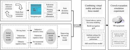
2.1. Research framework overview
The research method of this paper is shown in . First, we designed multifactor constraint rules under a multiexit selection constraint and a multifloor connection constraint and used the navigation grid in a VR scene to design a dynamic path planning method to realise emergency pedestrian evacuation path planning. Second, we improved the traditional social force model based on an ‘environmental role’ and a ‘subjective initiative’ so that it could accurately describe the evacuation characteristics of a crowd in a subway station fire environment. On this basis, we analysed the limitations of the above methods and models and then established an ISFM-based VR crowd evacuation simulation. Finally, we used VR equipment to simulate an emergency crowd evacuation during a subway station fire.
Figure 1. Overview of the research framework.
2.2. Dynamic planning method for evacuation paths with multifactor constraints
Path planning is the first step in a crowd evacuation simulation, and an efficient planning method can improve the efficiency of crowd evacuation simulation and shorten the path search time during evacuation (Zhang et al. Citation2016; Wang, Wei, and Dong Citation2021c). Therefore, in this study, we designed multiple factor constraint rules to achieve dynamic planning of evacuation paths using navigation grids in VR.
2.2.1. Multifactor constraint rules
The main passage areas of pedestrians in modern subway stations are generally the platform level, concourse level and multiple exits, which means that a traditional subway fire evacuation path planning method designed for a single exit and single floor is no longer applicable. Therefore, this paper proposes a path planning method based on multiple factor constraint rules, where the multiple factor constraint rules refer to multiexit selection constraints as well as multifloor connection constraints.
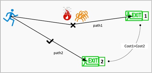
First, in this study, we consider the actual distance between the current position of evacuees and each exit position as well as the influence of the current environmental factors on the escape and carry out multiexit selection constraints. The specific exit selection process is as follows.
Determine the initial location
of evacuees and the set of evacuation exit positions
Determine whether the evacuees are in a safe area; if not, continue to the next step; if yes, the evacuation is successful, and the process ends.
Calculate the passage cost of the evacuees
Find the exit
A schematic of the pedestrian multiexit option is shown in .
Figure 2. Multiexit selection.
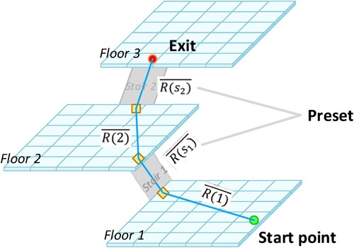
Second, due to the complex structure of multifloor subway stations, stairs or elevators have more inflection points, and the traditional navigation grid-based path planning methods in VR tend to generate more grids, which greatly increases the computation time of path planning. Considering that the optimal path at the stairs is often single, this study adds a ‘multifloor connection’ constraint to optimise the structure of the navigation grid. That is, by presetting the evacuation route of pedestrians at a staircase, a grid at and around the staircase is not generated in the virtual scene to reduce the number of grids to improve the efficiency of path planning. The specific connection process is as follows.
Set the total number of floors in the subway station as 3, and the evacuation path of the vacuees at the staircases of each floor as
Set the stairway entrance of each floor as the exit
Determine whether
Find the shortest path from the evacuee's current location
At this point, the total evacuation path is
Loop through steps (3) to (6) until the evacuation is successful and the optimal total path
A schematic diagram of the multifloor connection constraint is shown in .
Figure 3. Multifloor connection.
2.2.2. Dynamic planning of evacuation paths
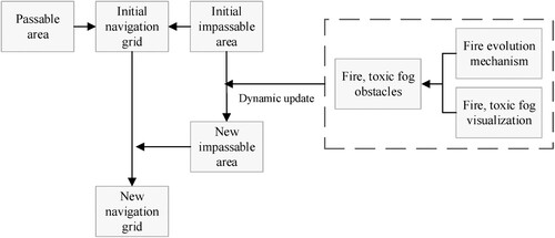
Based on the above multifactor constraint rules, this study makes full use of the navigation grid in a VR scene and establishes a dynamic planning method for crowd emergency evacuation paths. First, the virtual scene of a subway station was divided into passable and impassable areas to construct the initial navigation grid. Second, the navigation grid was dynamically updated based on a fire evolution mechanism, and flame and poisonous fog obstacles were dynamically generated in the scene to change the passable range of the navigation grid and the maximum height for people in the passable range, respectively. The navigation grid updating principle is shown in .
Figure 4. Dynamic update of the navigation grid.
Finally, we found all the grids of the pedestrian start-to-end path, generated route points based on the dynamically updated navigation grid and connected them into paths for evacuation path planning. A schematic diagram of the dynamic planning of the evacuation path is shown in .
Figure 5. Dynamic path planning.
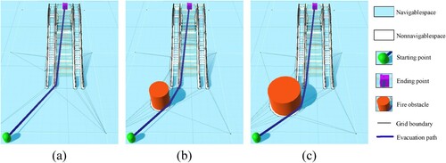
(a) shows the optimal evacuation path when the fire has not yet occurred; (b) shows the evacuation path when the fire has occurred, and we can see that the navigation grids are reconstructed and the evacuation path is dynamically updated due to the generation of the fire obstacle that change the passable area; (c) shows the dynamic update of the emergency evacuation path as the fire spread further.
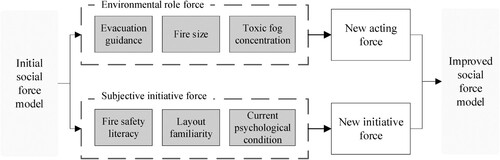
2.3. ISFM under an ‘environmental role’ and a ‘subjective initiative’
We used a crowd evacuation simulation-based social force model, which could more realistically reflect the interactions between microscopic individuals. However, in a complex subway station fire scenario, a traditional social force model describes the forces acting on pedestrians too crudely to take specific realistic factors (e.g. the fire, staff guidance, and pedestrian awareness) into account. To more accurately describe the emergency evacuation characteristics of the crowd in a subway station fire environment, this paper introduced an ‘environmental role force’ and a ‘subjective initiative force’.
2.3.1. Environmental role force analysis
The impact of a fire environment on the evacuation of people from a subway station is reflected in four main areas: evacuation guidance , visibility
, temperature
, and the toxicity level
(Hao et al. Citation2009). In this paper, these four influencing factors were combined to introduce an ‘environmental role parameter’
and determine the weight of each factor for the environmental influence based on the results of the literature (Jeon and Hong Citation2009) concerning the influencing factors of the evacuation of people from the Daegu subway fire. The expression of the environmental role parameter is
(3)
(3) where
takes the value of a random number between 0∼1. The weights of the three factors
,
, and
were determined with reference to the literature (Cao et al. Citation2014; Fang et al. Citation2012; and Nguyen, Ho, and Zucker Citation2013, respectively). The results are shown in .
Table 1. Weight divisions based on environmental danger degrees.
We then described the environmental role forces based on the social force model definition of repulsive forces as follows:
(4)
(4) where
is the sum of the model radii of pedestrian
and the corresponding environment
;
is the distance from pedestrian
to the model centre of the corresponding environment
;
is the environmental influence range; and
is the directional unit vector pointing from the corresponding environment
to pedestrian
, with the direction of the force determined by the environmental action parameter
.
2.3.2. Subjective initiative force analysis
In addition to environmental influences, the subjective awareness of pedestrians can also have an impact on the outcome of a crowd evacuation case. Having pedestrians with different levels of fire safety knowledge , different levels of familiarity with the subway station layout
and varying current psychological conditions
will affect the emergency evacuation of the crowd. In this paper, the first two parameters were used as weights with values from 0 to 1, and the current psychological state of the pedestrians was calculated based on the three environmental factors described above.
(5)
(5) Then, combined with the minimum evacuation speed for pedestrians, the improved expression for the desired crowd evacuation speed is
(6)
(6) Therefore, the expression for the subjective initiative force imposed on a pedestrian is.
(7)
(7) where
is the pedestrian’s mass;
is the initial desired rate of the pedestrian;
is the desired pedestrian movement direction;
is the actual velocity; and
is the reaction time.
By improving the social force model, evacuees have a more realistic force situation in a subway station fire scenario and can rely on effective staff command, improved fire safety knowledge and other initiatives to improve their evacuation efficiency. The social force model improvement process is shown in .
Figure 6. Social force model improvement process.
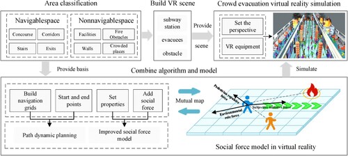
2.4. An ISFM-based method for a VR crowd evacuation simulation
Both the VR path planning approach discussed in Section 2.2 and the social force model-based crowd evacuation simulation technique introduced in Section 2.3 have several limitations. First, the path planning method in a VR scenario frequently exhibits ‘retrograde’ and ‘stuck’ phenomena when many people are evacuating at once. The pedestrian retrograde phenomenon and stuck phenomenon refer to the phenomena in which pedestrians cannot evacuate towards the correct path or become stuck in it due to repeated collisions between their own colliding bodies and other pedestrians/obstacles during the evacuation process, resulting in changes in the forwards directions of the pedestrians. Second, when using path planning methods in VR scenarios for crowd evacuation simulation purposes, the obtained evacuation results are not reliable due to the lack of evacuee attributes and specific environments. Third, when using a social force model for crowd evacuation simulation through 2D software, the simulation process is not effective, and the experience and immersion of the user are not sufficient. This does not allow for more accurate simulations and representations of individual evacuation behaviours and does not circumvent dynamic fire barriers.
Based on these problems, we established a VR crowd evacuation simulation method based on an ISFM. First, we divided a subway station into a navigable space and a nonnavigable space, added obstacle information such as toxic fire fog, and constructed a virtual geographic scene of a subway station fire. Second, we incorporated the dynamic evacuation path planning method introduced in Section 2.2, established pedestrian location information, and set the attributes of the evacuation crowd and the subway station environment according to the ISFM discussed in Section 2.3. After that, we added ‘social force’ to the pedestrians so that the ISFM could be applied to the constructed virtual environment (Li et al. Citation2021a). Finally, we created a VR interaction interface for users, set the position of a virtual camera in the scene and the roaming mode, and connected a VR device to realise an exploration paradigm in the evacuation simulation that combined active evacuation and passive evacuation. The use of VR technology for crowd evacuation simulation can immerse users in the whole crowd evacuation process and more intuitively show the emergency evacuation results to users. The idea of the simulation method is shown in .
Figure 7. VR simulation method for crowd evacuation.
3. Experiment
3.1. Preparation
3.1.1. Prototype system
Based on the above key technologies and methods, we developed a prototype system for a VR simulation of the crowd evacuation process during a subway station fire. shows the main system interface. The main applications are crowd evacuation simulation, escape route planning, subway scene display, and firefighting training. The evacuation simulation function contains two modes: ‘active evacuation’ and ‘passive evacuation’. In the active evacuation mode, users can move through the VR scenes by their own will and experience the whole process of evacuating from a subway station fire, which improves their sense of evacuation immersion and helps them learn evacuation skills. In the passive evacuation mode, that is, undergoing observation and experience while walking along the route specified by the system, users are able to macroscopically feel the crowd evacuation process; observe the behaviour of the crowd in the fire evacuation scenario; and provide reasonable suggestions for subway design, safety evaluations, and the development of evacuation plans for the operation process. The development environment for the prototype system is shown in .
Figure 8. Prototype system interface.
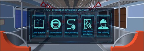
Table 2. Development environment information.
3.1.2. Case scenario
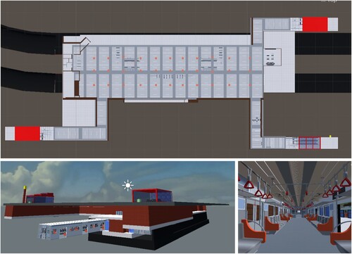
We constructed a 3D model of a subway station to carry out research on the proposed VR simulation method for emergency crowd evacuation. The subway station contained three floors, five staircases, three exits, two subway cars, various public passage areas and several obstacles and had an area of 14000 m2. shows diagrams of the virtual geographic scene of the subway station.
Figure 9. Experimental area.
3.2. Process
To make the experimental results more reliable, we set the characteristic attributes of the subway station and evacuees in the fire environment. First, the environmental attributes were set. We generated flames at temperatures higher than 60°C. The visibility property was represented in the VR scene as a cluster of smoke particles. The toxicity property was reflected in the VR scene by the colour of the smoke particles; the higher the toxicity was, the darker the smoke particles. Then, we set the pedestrian attributes. The pre-evacuation time, which refers to the time required for personnel to obtain fire information and start the evacuation process, is an important evacuation simulation parameter, and we set the pre-evacuation time for pedestrians to 20 s by referring to the literature (Wang et al. Citation2021a). Based on the statistics in the Human Dimensions of Chinese Adults, we set the diameters of evacuees as random numbers between 30 and 40 cm with reference to the average human shoulder width and chest thickness. We set the number of evacuees to 1000 based on a certain instantaneous number of people at the Southwest Jiaotong University subway station in Chengdu. According to Liu et al. (Citation2017), we counted the average walking speeds of people with different characteristics in emergency situations, and the settings are shown in .
Table 3. Walking speeds of people with different characteristics.
Then, the experimental procedure of this paper was divided into three main steps. The first step involved the dynamic planning of the evacuation path. To validate the feasibility of the planning method, experiments were conducted to observe the exit selection and dynamic path updates faced by two pedestrians over time and under shifting fire dynamics. We then studied the number of navigation grids around the staircase and compared the evacuation path update times before and after applying the multifactor constraints to determine the simulation frame rate in a VR environment and ensure a smooth user experience in the evacuation simulation.
The second step was to verify the simulation effectiveness of the method proposed in this paper and its evacuation efficiency in the simulation case. For this step, we used Pathfinder 2019.2, a commercial software that is commonly used in evacuation simulations; it is a new intuitive and easy-to-use intelligent emergency evacuation and escape assessment system. It has been widely used by many scholars for crowd evacuation simulation training and has quite reliable experimental results (Qin, Liu, and Huang Citation2020; Sudte and Patvichaichod Citation2020). We could set the parameters used by the method developed in this paper in this software and control certain variables to explore the evacuation efficiency of the proposed method in a simulation case.
We observed the whole crowd evacuation process and conducted three groups of crowd evacuation simulation experiments with the same scenario and personnel, and each group was tested 30 times. Among them, Subgroup I used Pathfinder for computational analysis and selected the steering mode for evacuation simulation purposes, Subgroup II conducted a VR crowd evacuation simulation based on the original social force model, and Subgroup III conducted a VR crowd evacuation simulation based on the ISFM. The personnel distribution and basic attribute settings were the same for all three groups of evacuation simulation experiments. The ISFM of Subgroup III added environmental role forces and subjective initiative forces to the evacuees.
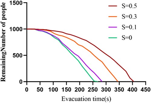
Finally, we explored the crowd evacuation times yielded by the ISFM under different degrees of environmental effect. We obtained the crowd evacuation times when ,
,
, and
by adjusting the above environmental attributes and using EquationEquation (3
(5)
(5) ) to find the average approximation of the environmental role parameter
, where
meant that no environmental action effect was present.
4. Results and analysis
4.1. Analysis of dynamic path planning results
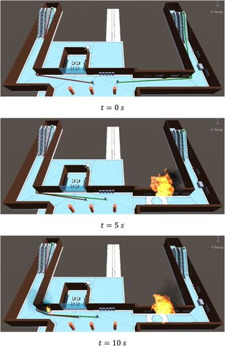
shows the dynamic evacuation path planning results under the multifactor constraints. From the figure, when = 0 s, pedestrians are not affected by environmental factors such as fire and will automatically choose the exit closest to them to escape. When
= 5 s, a giant fire occurs on the escape route of the pedestrian on the right, so that they have no choice but to change their escape exit, completing the exit selection and dynamically updating their evacuation path. Finally, at
= 10 s, a small fire occurs on the escape route of the left exit, and the two pedestrians dynamically update their evacuation path again to avoid the fire obstacle, proving the effectiveness of the proposed method for dynamic path planning and multiexit selection.
Figure 10. Experimental results of dynamic path planning with multifactor constraints. (a) , (b)
, (c)
.
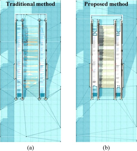
In addition to the dynamic path planning and multiexit selection constraints, this paper also adds a multifloor connection constraint to optimise the structure of the navigation grid in the VR scene. (b) shows the navigation grid generated using the proposed method, and (a) shows the navigation grid generated using a traditional method. The proposed method significantly reduces the number of grids.
Figure 11. Comparison of the number of navigation grids.
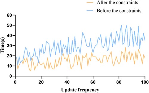
shows a comparison of the dynamic path update elapsed time before and after applying the multifactor constraint. From the figure, before the constraint each path update consumes 33.02 ms on average, and after the constraint only consumes 15.48 ms on average. The VR running frame rate can reach more than 60 fps on average, and the path update elapsed time after the constraint is more stable than before the constraint, which improves the dynamic path planning efficiency. The adaptability of the proposed method for complex virtual scenarios of multifloor and multiexit subway stations has been demonstrated.
Figure 12. Dynamic path update efficiency comparison.
4.2. Analysis of the crowd evacuation simulation results
shows a comparison between the crowd evacuation simulation effects produced before and after combining the path planning method in VR with the ISFM. Several findings are described as follows.
Figure 13. Simulation of a crowd evacuating from a subway station fire.
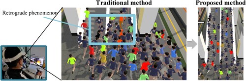
First, the combination of the VR path planning method and the social force model effectively reduced the occurrence of the pedestrian ‘retrograde’ and ‘stuck’ phenomena and improved the crowd evacuation efficiency. This is because traditional path planning methods for VR scenarios have predefined collision detection strategies for pedestrians and limited evacuation exits, and pedestrians often need to share the same path points when traversing the navigation grid, which leads to a tendency for pedestrians to line up when approaching an entrance from the same side or to form bottlenecks when trying to cross an entrance from different directions, causing repeated collisions between evacuees and other pedestrians or static obstacles. However, the traditional path planning method in VR combined with the social force model imposes certain repulsive forces between pedestrians and between pedestrians and obstacles, which changes the direction of pedestrian movement. Moreover, the ISFM proposed in this paper also has an environmental role force and a subjective initiative force, which help pedestrians make better route selections, reducing collisions and improving evacuation efficiency.
Second, the combination of the VR path planning method and social force model allowed for more accurate descriptions of evacuees. By combining the path planning method introduced in Section 2.2 with the social force model, we could set the attributes of the environment as well as pedestrians to accurately characterise the evacuation of people from a subway station fire environment.
Third, the combination of the VR path planning method and social force model enhanced the crowd evacuation simulation effect. It enabled us to apply the social force model to a VR environment, thereby solving the problem regarding the poor simulation effects of traditional crowd simulation methods and enhancing the visual expression of the evacuation results. The proposed approach is more conducive to decision making and analyses with respect to metro station staff.
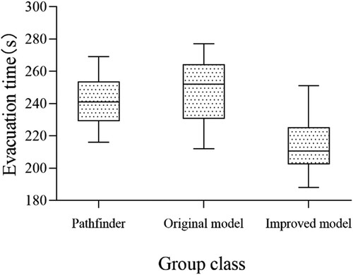
presents a comparison between the evacuation times achieved for different groups, and we can draw the following conclusions. First, the ISFM had the shortest average evacuation time (M = 214.7 s), with an average evacuation efficiency improvement of 12.53% over the commercial Pathfinder software (M = 241.6 s) and an average evacuation efficiency improvement of 15.37% over the original social force model (M = 247.7 s). This was due to the improved model considering the effective evacuation of pedestrians on the side of the subway station as well as each pedestrian’s own subjective initiative, improving the evacuation efficiency. Second, the evacuation time of the commercial Pathfinder software exhibited a normal distribution, while the other two groups had skewed distributions because the Pathfinder software does not support the avoidance of dynamic fire barriers and cannot consider the effect of fire spread on crowd evacuation; however, the other two groups were able to dynamically avoid the fire based on a fire evolution mechanism, making the evacuation results more stochastic. Third, the results of the original social force model were more dispersed than those of the other two groups because this model is greatly influenced by the size of the given fire. Additionally, the evacuation time increased rapidly with the severity of the disaster, while the ISFM included an environmental role force and a subjective initiative force, which weakened the influence of the size of the fire on the evacuation of the crowd to a certain extent.
Figure 14. Evacuation time of each group.
presents a graph comparing the evacuation times achieved under environmental effects, where is the environmental role parameter calculated from EquationEquation (3
(5)
(5) ), and a larger value of
indicates a more serious disaster. From the figure, we can conclude that the crowd evacuation time of the ISFM was affected by the severity of the disaster situation, and the evacuation time of the heavily affected area was 135 s longer than that of the unaffected area.
Figure 15. Evacuation times achieved under varying environmental effects.
In summary, the proposed method not only considers the accurate descriptive nature of the ISFM but can also effectively use VR technology to produce good visualisations of the output simulation results, enabling users to immerse themselves in an emergency subway station fire evacuation site, improving evacuation efficiency while also solving the poor visualisation problem of the traditional evacuation simulation experiments.
5. Discussion
VR technology is an essential means of realising a digital earth. At the same time, simulating the disaster occurrence and crowd evacuation process in a VR scenario can provide users with good visual effects and help with the analyses of emergency responders and the digital applications of grassroots emergency drills. Path planning is an essential step in crowd evacuation simulation. However, existing path planning methods are often limited to 2D and ordinary 3D scenes, so they cannot dynamically plan the escape paths of pedestrians in a VR world, and they have long path search times and poor adaptability to complex environments. In addition, existing crowd evacuation simulation methods cannot effectively recreate the scene of a disaster due to inefficient evacuation processes, unrealistic evacuation results, and poor simulation effects. Therefore, we propose an improved social force model (ISFM)-based crowd evacuation simulation method in virtual reality. The main contributions of this paper are as follows.
First, the navigation grid-based pathfinding algorithm was extended according to the multiexit and multifloor constraints. The problem of difficult path planning in multiexit and multifloor scenarios was solved. Optimising the navigation grid's structure in the virtual scene improves the efficiency of path dynamic planning. This ensures the smoothness of crowd evacuation simulation. By combining the path dynamic planning algorithm with the social force model, it effectively reduces the occurrence of pedestrian ‘retrograde’ and ‘stuck’ phenomena and realises the dynamic evacuation of evacuees to avoid fire obstacles.
Second, we introduced parameters such as the environmental role and subjective initiative of pedestrians to further improve the social force model, which not only reflects the movement state of pedestrians in real subway fire evacuation but also improves the efficiency of crowd evacuation in the simulation. The simulation results show that the crowd evacuation efficiency in the simulation is improved by 12.53% on average over the commercial Pathfinder software and by 15.37% on average over the original social force model. Moreover, the crowd evacuation time of the ISFM is influenced by the severity of the disaster; the more severe the disaster is, the longer the evacuation time.
Third, we have effectively combined the social force model with VR to solve the problem of poor visualisation simulation in traditional crowd evacuation experiments. Moreover, the system we developed has two interaction modes: active evacuation and passive evacuation. Passengers can experience the subway fire evacuation scene immersively through our VR system. Compared with traditional simulation methods, the most significant advantages of using VR for crowd evacuation simulation are safety and low cost. VR can help passengers retain evacuation knowledge for a more extended period of time to improve their ability to prevent risks, help managers observe the station facilities and evacuation effects and provide a reference for emergency evacuation plans for subway fires (Feng et al. Citation2018; Bourhim and Cherkaoui Citation2020).
6. Conclusion
This study combined an ISFM and VR technology to simulate the whole crowd evacuation process before and after a fire and analysed the effectiveness of this method through experiments. According to our results, the developed dynamic path planning method based on multifactor constraint rules helped to shorten the path search time during the evacuation process; thus, it can adapt to complex subway station fire environments with multiple exits and floors and meets the basic user requirements regarding the visual fluency of a virtual scene. The ISFM allows evacuees to experience a more realistic force situation in a subway station fire scenario and can improve crowd evacuation efficiency by relying on effective staff commands, improving fire safety literacy, and completing other initiatives. Although the above research has made some progress, some aspects can still be improved. For example, our study only used the ISFM for a fire evacuation scenario at a subway station. In future research, first, we will use VR technology to focus more on the impact of different environmental parameters on real evacuation and add more descriptions to the social force model so that it can be adapted to more diverse disaster escape scenarios. Second, we will add combustible or noncombustible substances to the virtual scenario to influence the spread of fire, import spatial and temporal data of subway smoke distribution, and conduct real fire evacuation experiments in collaboration with metro companies and fire departments to explore more factors affecting evacuation.
Author contributions
Conceptualisation, Jun Zhu; Methodology, Jinbin Zhang; Resources, Jigang You, Yukun Gou, Yuxuan Zhou and Lin Fu; Software, Jinbin Zhang and Pei Dang; Validation, Jun Zhu, Weilian Li, Jianlin Wu; Writing – original draft, Jinbin Zhangjin; Writing—review & editing, Jun Zhu and Weilian Li. All authors have read and agreed to the published version of the manuscript.
Disclosure statement
No potential conflict of interest was reported by the author(s).
Data availability statement
The data that support the findings of this study are available from the corresponding author, Zhu, upon reasonable request.
Additional information
Funding
References
- Bakar, N. A. A., M. A. Majid, and K. Adam. 2019. “Simulation and Modelling the Human Crowd Evacuation.” IOP Conference Series: Materials Science and Engineering 551: 0012038–0012038. doi:10.1088/1757-899X/551/1/012038.
- Bourhim, E. M., and A. Cherkaoui. 2020. “Efficacy of Virtual Reality for Studying People's pre-Evacuation Behavior Under Fire.” International Journal of Human-Computer Studies 142: 102484. doi:10.1016/j.ijhcs.2020.102484.
- Cagigas-Muñiz, D., F. Diaz-del-Rio, J. L. Sevillano-Ramos, and J. L. Guisado-Lizar. 2022. “Efficient Simulation Execution of Cellular Automata on GPU.” Simulation Modelling Practice and Theory 118: 102519. doi:10.1016/j.simpat.2022.102519.
- Cao, S. C., W. G. Song, X. D. Liu, and N. Mu. 2014. “Simulation of Pedestrian Evacuation in a Room Under Fire Emergency.” Procedia Engineering 71: 403–409. doi:10.1016/j.proeng.2014.04.058.
- Charalambopoulos, N., and A. C. Nearchou. 2021. “Ship Routing Using Genetic Algorithms.” Operations Research Forum 2 (3), doi:10.1007/S43069-021-00093-W.
- Chen, M., and H. Lin. 2018. “Virtual Geographic Environments (VGEs): Originating from or Beyond Virtual Reality (VR)?.” International Journal of Digital Earth 11 (4): 329–333. doi:10.1080/17538947.2017.1419452.
- Dang, P., J. Zhu, S. Pirasteh, W. Li, J. You, B. Xu, and C. Liang. 2021. “A Chain Navigation Grid Based on Cellular Automata for Large-Scale Crowd Evacuation in Virtual Reality.” International Journal of Applied Earth Observation and Geoinformation 103: 102507. doi:10.1016/j.jag.2021.102507.
- Ding, N., T. Chen, Y. Zhu, and Y. Lu. 2021. “State-of-the-art High-Rise Building Emergency Evacuation Behavior.” Physica A: Statistical Mechanics and Its Applications 561: 125168. doi:10.1016/j.physa.2020.125168.
- Fang, Z. M., W. G. Song, J. Zhang, and H. Wu. 2012. “A Multi-Grid Model for Evacuation Coupling with the Effects of Fire Products.” Fire Technology 48: 91–104. doi:10.1007/s10694-010-0173-x.
- Feng, Z., V. A. González, R. Amor, R. Lovreglio, and G. Cabrera-Guerrero. 2018. “Immersive Virtual Reality Serious Games for Evacuation Training and Research: A Systematic Literature Review.” Computers & Education 127: 252–266. doi:10.1016/j.compedu.2018.09.002.
- Guo, Y., J. Zhu, Y. Wang, J. Chai, W. Li, L. Fu, B. Xu, and Y. Gong. 2020. “A Virtual Reality Simulation Method for Crowd Evacuation in a Multiexit Indoor Fire Environment.” ISPRS International Journal of Geo-Information 9 (12): 750. doi:10.3390/ijgi9120750.
- Gwynne, S., M. Amos, M. Kinateder, N. Benichou, K. Boyce, C. N. van Der Wal, and E. Ronchi. 2020. “The Future of Evacuation Drills: Assessing and Enhancing Evacuee Performance.” Safety Science 129: 104767. doi:10.1016/j.ssci.2020.104767.
- Halik, Ł, and A. J. Kent. 2021. “Measuring User Preferences and Behaviour in a Topographic Immersive Virtual Environment (TopoIVE) of 2D and 3D Urban Topographic Data.” International Journal of Digital Earth 14 (12): 1835–1867. doi:10.1080/17538947.2021.1984595.
- Hao, S. Q., H. W. Huang, Y. Yuan, and K. Yin. 2009. “Fire Evacuation Underground Space Based on Building EXODUS.” 2009 IEEE International Conference on Engineering Computation, Hong Kong, May, 186–188. doi:10.1109/ICEC.2009.31.
- Helbing, D., and P. Molnar. 1995. “Social Force Model for Pedestrian Dynamics.” Physical Review E 51 (5): 4282. doi:10.1103/PhysRevE.51.4282.
- Hosseini, O., M. Maghrebi, and M. F. Maghrebi. 2021. “Determining Optimum Staged-Evacuation Schedule Considering Total Evacuation Time, Congestion Severity and Fire Threats.” Safety Science 139: 105211. doi:10.1016/j.ssci.2021.105211.
- Jeon, G., and W. Hong. 2009. “Characteristic Features of the Behavior and Perception of Evacuees from the Daegu Subway Fire and Safety Measures in an Underground Fire.” Journal of Asian Architecture and Building Engineering 8 (2): 415–422. doi:10.3130/jaabe.8.415.
- Jiang, Y., Z. Li, and S. L. Cutter. 2021. “Social Distance Integrated Gravity Model for Evacuation Destination Choice.” International Journal of Digital Earth 14 (8): 1004–1018. doi:10.1080/17538947.2021.1915396.
- Jin, B., J. Wang, Y. Wang, Y. Gu, and Z. Wang. 2020. “Temporal and Spatial Distribution of Pedestrians in Subway Evacuation Under Node Failure by Multi-Hazards.” Safety Science 127: 104695. doi:10.1016/j.ssci.2020.104695.
- Ju, W., J. Wu, Q. Kang, J. Jiang, and Z. Xing. 2022. “Fire Risk Assessment of Subway Stations Based on Combination Weighting of Game Theory and TOPSIS Method.” Sustainability 14 (12): 7275. doi:10.3390/su14127275.
- Kim, J. H., and Y. S. Ban. 2013. “A Study on Characteristics of Visual Fixation in an Evacuation Process Created via Virtual Reality-Focusing on Subway Evacuation Simulation.” Journal of the Architectural Institute of Korea Planning and Design 29 (9): 33–42. doi:10.5659/JAIK_PD.2013.29.9.33.
- Kopsidas, A., and K. Kepaptsoglou. 2022. “Identification of Critical Stations in a Metro System: A Substitute Complex Network Analysis.” Physica A: Statistical Mechanics and its Applications 596: 127123. doi:10.1016/j.physa.2022.127123.
- Li, J., and H. Zhang. 2022a. “Crowd Evacuation Simulation Research Based on Improved Reciprocal Velocity Obstacles (RVO) Model with Path Planning and Emotion Contagion.” Transportation Research Record: Journal of the Transportation Research Board 2676 (3): 740–757. doi:10.1177/03611981211056910.
- Li, W., J. Zhu, L. Fu, Q. Zhu, Y. Guo, and Y. Gong. 2021a. “A rapid 3D reproduction system of dam-break floods constrained by post-disaster information.” Environmental Modelling & Software 139: 104994. doi:10.1016/j.envsoft.2021.104994.
- Li, W., J. Zhu, L. Fu, Q. Zhu, Y. Xie, and Y. Hu. 2021b. “An augmented representation method of debris flow scenes to improve public perception.” International Journal of Geographical Information Science 35 (8): 1521–1544. doi:10.1080/13658816.2020.1833016.
- Li, W., J. Zhu, J. Haunert, L. Fu, Q. Zhu, and Y. Dehbi. 2022b. “Three-dimensional virtual representation for the whole process of dam-break floods from a geospatial storytelling perspective.” International Journal of Digital Earth 15 (1): 1637–1656. doi:10.1080/17538947.2022.2118877.
- Lim, Y., and Y. Ahn. 2018. “A Study on Comparative Analysis About Evacuation Results According to Advance Information in Underground Subway Fire.” Journal of the Korean Society of Hazard Mitigation 18 (2): 223–230. doi:10.9798/KOSHAM.2018.18.2.223.
- Lin, H., B. Xu, Y. Chen, W. Li, L. You, and J. He. 2022. “VGES as a New Platform for Urban Modeling and Simulation.” Sustainability 14 (13): 7980. doi:10.3390/su14137980.
- Liu, B., Y. Han, H. Zhang, and X. Qin. 2017. “Research of Crowd Evacuation Simulation Based on the Machine Learning.” Journal of Computational and Theoretical Nanoscience 14 (1): 815–820. doi:10.1166/jctn.2017.6279.
- Lochhead, I., and N. Hedley. 2019. “Mixed Reality Emergency Management: Bringing Virtual Evacuation Simulations Into Real-World Built Environments.” International Journal of Digital Earth 12 (2): 190–208. doi:10.1080/17538947.2018.1425489.
- Lu, L., H. Zhuang, and Z. Gao. 2018. “Evaluation of Dispersed Effect Based on Social Force-Based Vehicle Model and Emotional Infection Model: A Data Simulation Approach.” International Journal of High Performance Systems Architecture 8 (1-2): 105–113. doi:10.1504/IJHPSA.2018.094148.
- Ma, L., H. Zhang, S. Meng, and J. Liu. 2022. “Volcanic Ash Region Path Planning Based on Improved A-Star Algorithm.” Journal of Advanced Transportation 2022, doi:10.1155/2022/9938975.
- Nguyen, M. H., T. V. Ho, and J. D. Zucker. 2013. “Integration of Smoke Effect and Blind Evacuation Strategy (SEBES) Within Fire Evacuation Simulation.” Simulation Modelling Practice and Theory 36: 44–59. doi:10.1016/j.simpat.2013.04.001.
- Nurcahyadi, T., C. Blum, and F. Manyà. 2022. “Negative Learning Ant Colony Optimization for MaxSAT.” International Journal of Computational Intelligence Systems 15 (1): 1–19. doi:10.1007/s44196-022-00120-6.
- Ou, Y., Y. Fan, X. Zhang, Y. Lin, and W. Yang. 2022. “Improved A* Path Planning Method Based on the Grid Map.” Sensors 22 (16): 6198. doi:10.3390/s22166198.
- Pütz, S., T. Wiemann, J. Sprickerhof, and J. Hertzberg. 2016. “3d Navigation Mesh Generation for Path Planning in Uneven Terrain.” IFAC-PapersOnLine 49 (15): 212–217. doi:10.1016/j.ifacol.2016.07.734.
- Qin, J., C. Liu, and Q. Huang. 2020. “Simulation on Fire Emergency Evacuation in Special Subway Station Based on Pathfinder.” Case Studies in Thermal Engineering 21: 100677. doi:10.1016/j.csite.2020.100677.
- Raheem, F. A., and U. I. Hameed. 2019. “Heuristic D* Algorithm Based on Particle Swarm Optimization for Path Planning of Two-Link Robot Arm in Dynamic Environment.” Al-Khwarizmi Engineering Journal 15 (2): 108–123. doi:10.22153/kej.2019.01.004.
- Soltani, E., and E. Kashi. 2022. “Pedestrian Simulation and PLOS Analysis in the Subway Station.” Innovative Infrastructure Solutions 7 (1): 1–9. doi:10.1007/s41062-021-00662-2.
- Sudte, J., and S. Patvichaichod. 2020. “Evacuation Time Analysis of High-Rise Building by Using Pathfinder Case Study: Residential Occupancy.” IOP Conference Series: Materials Science and Engineering 715 (1): 0012007. doi:10.1088/1757-899X/715/1/012007.
- Sugiyama, T., and K. Yamori. 2020. “Consideration of Evacuation Drills Utilizing the Capabilities of People with Special Needs.” Journal of Disaster Research 15 (6): 794–801. doi:10.20965/jdr.2020.p0794.
- Sun, Y., and H. Liu. 2021. “Crowd Evacuation Simulation Method Combining the Density Field and Social Force Model.” Physica A: Statistical Mechanics and its Applications 566: 125652. doi:10.1016/j.physa.2020.125652.
- Vahidnia, M. H., A. A. Alesheikh, S. Behzadi, and S. Salehi. 2013. “Modeling the Spread of Spatio-Temporal Phenomena Through the Incorporation of ANFIS and Genetically Controlled Cellular Automata: A Case Study on Forest Fire.” International Journal of Digital Earth 6 (1): 51–75. doi:10.1080/17538947.2011.603366.
- Wang, N., Y. Gao, C. Y. Li, and W. M. Gai. 2021a. “Integrated Agent-Based Simulation and Evacuation Risk-Assessment Model for Underground Building Fire: A Case Study.” Journal of Building Engineering 40: 102609. doi:10.1016/j.jobe.2021.102609.
- Wang, C., Y. Tang, M. A. Kassem, H. Li, and Z. Wu. 2021b. “Fire Evacuation Visualization in Nursing Homes Based on Agent and Cellular Automata.” Journal of Safety Science and Resilience 2 (4): 181–198. doi:10.1016/j.jnlssr.2021.08.006.
- Wang, J., G. Wei, and X. Dong. 2021c. “A Dynamic Fire Escape Path Planning Method with BIM.” Journal of Ambient Intelligence and Humanized Computing 12 (11): 10253–10265. doi:10.1007/s12652-020-02794-2.
- Wang, Z., C. Zhang, J. Wang, Z. Zheng, and L. Li. 2021d. “Research on Path Planning Algorithm for Crowd Evacuation.” Symmetry 13 (8): 1339. doi:10.3390/sym13081339.
- Xiong, J., E. L. Hsiang, Z. He, T. Zhan, and S. T. Wu. 2021. “Augmented Reality and Virtual Reality Displays: Emerging Technologies and Future Perspectives.” Light: Science & Applications 10 (1): 216. doi:10.1038/s41377-021-00658-8.
- Xu, L., K. Huang, J. Liu, D. Li, and Y. F. Chen. 2022. “Intelligent Planning of Fire Evacuation Routes Using an Improved ant Colony Optimization Algorithm.” Journal of Building Engineering 61: 105208. doi:10.1016/j.jobe.2022.105208.
- YenChern, N., C. WaiShiang, S. KengWai, M. A. bin Khairuddin, N. bt Jali, and E. ak Mit. 2021. “Developing Fire Evacuation Simulation Through BDI-Based Modelling and Simulation.” Journal of Physics: Conference Series 2107 (1): 0012047. doi:10.1088/1742-6596/2107/1/012047.
- Yuan, Z., H. Jia, L. Zhang, and L. Bian. 2018. “A Social Force Evacuation Model Considering the Effect of Emergency Signs.” Simulation 94 (8): 723–737. doi:10.1177/0037549717741350.
- Zainuddin, Z., and M. Shuaib. 2010. “Modification of the Decision-Making Capability in the Social Force Model for the Evacuation Process.” Transport Theory and Statistical Physics 39 (1): 47–70. doi:10.1080/00411450.2010.529979.
- Zhai, L., and S. Feng. 2022. “A Novel Evacuation Path Planning Method Based on Improved Genetic Algorithm.” Journal of Intelligent & Fuzzy Systems 42 (3): 1813–1823. doi:10.3233/JIFS-211214.
- Zhang, L., M. Liu, X. Wu, and S. M. AbouRizk. 2016. “Simulation-based Route Planning for Pedestrian Evacuation in Metro Stations: A Case Study.” Automation in Construction 71: 430–442. doi:10.1016/j.autcon.2016.08.031.
- Zhang, Y. Y., Y. C. Shen, and L. N. Ma. 2014. “Pathfinding Algorithm of 3D Scene Based on Navigation Mesh.” Advanced Materials Research 1030: 1745–1750. doi:10.4028/www.scientific.net/AMR.1030-1032.1745.
- Zhang, H., J. Xu, L. Jia, and Y. Shi. 2022. “Modelling the Walking Behavior of Pedestrians in the Junction with Chamfer Zone of Subway Station.” Physica A: Statistical Mechanics and its Applications 602, doi:10.1016/j.physa.2022.127656.
- Zheng, X., H. Y. Li, L. Y. Meng, X. Y. Xu, and X. Chen. 2015. “Improved Social Force Model Based on Exit Selection for Microscopic Pedestrian Simulation in Subway Station.” Journal of Central South University 22 (11): 4490–4497. doi:10.1007/s11771-015-2997-5.
- Zhong, M., C. Shi, X. Tu, T. Fu, and L. He. 2008. “Study of the Human Evacuation Simulation of Metro Fire Safety Analysis in China.” Journal of Loss Prevention in the Process Industries 21 (3): 287–298. doi:10.1016/j.jlp.2007.08.001.
- Zhu, Y., B. Ding, J. Bao, Z. Mao, and X. Teng. 2019. “Social Force 3D Evacuation Model Based on Improved Ant Colony Algorithm.” In 1st International Symposium on Innovation and Education, Law and Social Sciences (IELSS 2019), edited by Wadim Striełkowski , 35–46. Shenyang: Atlantis Press. doi:10.2991/ielss-19.2019.8.
- Zhu, Y., F. Han, Y. Yang, and X. Li. 2022. “Fire Evacuation Integration Modelling in Subway Station Using the Lattice Boltzmann Method.” Proceedings of the Institution of Civil Engineers - Transport 2022: 1–12. doi:10.1680/jtran.22.00052.