
ABSTRACT
In 2014, The GEOSS Water Strategy – From Observations to Decisions was published and steps were taken to implement the Strategy’s recommendations. The Strategy highlighted priority areas where the application of Earth observations to water research and water management decisions would have significant scientific and societal benefits. This article reviews the implementation of the Strategy’s recommendations over the past eight years. After a review of the Strategy’s assessment of the needs for water observations and their applications, it then reviews actions taken in response to the Strategy’s recommendations in its four major themes: improved data acquisition for Essential Water Variables, research and product development, interoperability, and capacity development. It highlights significant achievements in the implementation of the Strategy including some motivated by factors beyond this Strategy, reviews actions taken by participating agencies and programs for each of the main themes and summarizes the remaining challenges in achieving the Strategy’s full implementation. The article not only is an update for the Water Community regarding the GEOSS Water Strategy, but it is also an example of how other communities could develop and promulgate a set of strategic recommendations, monitor progress, and carry out assessments of their effectiveness.
List of Acronyms
| AmeriGEO | = | Coordination Framework for GEOSS in the Americas |
| AquaWatch | = | GEO Water Quality Initiative |
| ARSET | = | Applied Remote Sensing Training program |
| AWCI | = | Asian Water Cycle Initiative |
| CEOS | = | Committee on Earth Observation Satellites |
| CNES | = | Centre National d'Études Spatiales |
| ESA | = | European Space Agency |
| ECV | = | Essential Climate Variables |
| EWV | = | Essential Water Variables |
| FAO | = | UN Food and Agriculture Organization |
| GCOS | = | Global Climate Observing System |
| GEMS | = | Global Environmental Monitoring System |
| GEO | = | Group on Earth Observations |
| GEOGloWS | = | GEO Global Water Sustainability |
| GEOSS | = | Group on Earth Observations System of Systems |
| GEWEX | = | Global Energy and Water Cycle Exchanges |
| GKH | = | GEO Knowledge Hub |
| GRACE | = | Gravity Recovery and Climate Experiment |
| GRACE-F-O | = | Gravity Recovery and Climate Experiment Follow-on |
| GRDC | = | Global Runoff Data Centre |
| GTN-H | = | Global Terrestrial Network Hydrology |
| IGWCO | = | Integrated Global Water Cycle Observations |
| JAXA | = | Japan Aerospace Exploration Agency |
| LDAS | = | Land Data Assimilation Systems |
| LEGOS | = | Laboratoire d’Études Cyrospheriques et Océanographie Spatiale |
| NASA | = | National Aeronautics and Space Administration |
| NOAA | = | National Oceanic and Atmospheric Administration |
| SDG | = | Sustainable Development Goals |
| SERVIR | = | ‘to serve’ in Spanish |
| SWOT | = | Surface Water Ocean Topography |
| UN | = | United Nations |
| US | = | United States |
| USAID | = | United States Agency for International Development |
| WMO | = | World Meteorological Organization |
| WSIST | = | Water Strategy Implementation Study Team |
1. Introduction
Water continues to be a critical issue for individuals, communities, societies and nations affecting their health, well-being, prosperity, and local and international relations. Although water is essential for life on Earth, it is under stress due to the increasing demands for this finite resource and its sensitivity to anthropogenic effects such as pollution, environmental degradation, and climate change among others. The Group on Earth Observations (GEO) seeks to help address this critical resource issue by providing access to Earth observations, products and tools to support water governance and management. This article details results from a near decade long multi-agency effort led by GEO. It was undertaken to strengthen the policies and practices that govern how water data are acquired, disseminated to scientists and water managers, and used in research and applications. It also outlines steps being taken to develop regional expertise to expand the use of these data and services in all parts of the world.
The issues surrounding the availability and use of water on local, regional and global scales continue to challenge water resource managers. A great deal of public attention on water issues is directed at the needs of society for adequate clean water and the future of regional water availability under climate change. For more than four decades experts have been issuing warnings about the vulnerability of our water resources and the world’s under-privileged populations who live in areas where water is at risk from shortages in supply and contamination. These areas tend to be the most vulnerable to population growth and environmental change (Falkenmark and Lindh Citation1976; Vörösmarty et al. Citation2000). Work by Vörösmarty et al. (Citation2004) was central in documenting these concerns and researching their consequences on a basin scale. The scientific community began to understand that human activity could have a major impact on the water cycle. In this period of human influence, later referred to as the Anthropocene, it became increasingly urgent to develop a system capable of monitoring environmental changes (Lawford et al. Citation2013a) and to pursue scientific approaches that would develop the knowledge and skills needed to analyze problems arising from the interactions of humans with the global water cycle (Vörösmarty et al. Citation2013).
Policy responses to these growing environmental uncertainties have been forthcoming. In recognition of these uncertainties and as a result of similar discussions within the World Water Forum and other international bodies, the United Nations (UN) approved water and sanitation as a human right for every person (UN General Assembly Resolution 64/292, 2010 (retrieved from https://digitallibrary.un.org/record/687002?ln = en on January 27, 2023), and later directed member nations to implement Integrated Water Resources Management approaches through the UN Sustainable Development Goals (see UN SDG 6, Target 5: https://sdgs.un.org/goals).
Regional responses have also been brought forward such as the European Parliament’s 2020 directive on the quality of water intended for human consumption (European Union Citation2008) and the need to ensure water resource managers can adapt to the future impacts of climate change on water resources (Kundzewicz et al. Citation2008). Although policy revisions can be useful in making general broad scale changes, water managers in a basin commission or a government ministry are often the ones who must ensure changes happen in a safe and socially acceptable way. This article describes one way in which GEO is trying to empower decision-makers working within policy frameworks by using management initiatives and providing access to the best and most relevant information.
GEO is a partnership of nations and organizations that seeks to realize a future where decisions and actions for the benefit of humankind are informed by ‘coordinated, comprehensive and sustained Earth observations’ (GEO Citation2005). GEO’s overall objective is to develop a Global Earth Observation System of Systems (GEOSS). It helps scientists and decision-makers use Earth observations to assess large-scale changes and guides them in taking actions that minimize local and national risks. GEO also advances awareness of the role of Earth observations in managing social and economic activities, especially for important public policy issues, such as climate change and sustainable development.
As a result of a growing awareness of water issues, a large number of Earth observing satellites each generally dedicated to providing observations of an individual water cycle variable have been launched over the past two decades.. The GEOSS Water Strategy (GEO Citation2014) described in this article aims to help make water observations more plentiful, accessible, meaningful, and usable for the water management through a set of coherent actions and plans to ensure that the water resources community locally and globally can access data and adequate display and analysis tools. Within GEO, the Strategy’s goal was to provide a framework for guiding decisions regarding priorities and strategies for the development, maintenance, and enhancement of water observations and data products, and plans for expanding the use of these data sets and products. The GEOSS Water Strategy is unique from other water strategies such as those global water strategies developed by the Global Water Partnership and the US government because it focuses on the science and practices of Earth observations and their integration into water management through the GEOSS framework. It should be noted that the GEOSS Water Strategy addresses freshwater specifically and leaves ocean issues to the GEO Blue Planet initiative (GEO Citation2022a).
Both GEO and the Committee on Earth Observation Satellites (CEOS) recognized the benefit of a strategy for freshwater and supported the development of the GEOSS Water Strategy. The preparation of the final report on the Strategy was overseen by GEO and led by the Integrated Global Water Cycle Observations (IGWCO) Community of Practice, with support from the Japan Aerospace Exploration Agency (JAXA) and the National Aeronautics and Space Administration (NASA). The Strategy assesses data availability and services in the context of the needs for water cycle research and in priority application areas for decision-making in the water sector. Among other priorities, these topics include drought monitoring and prediction; early warning systems for floods; monitoring capabilities for achieving the UN’s Sustainable Development Goals (SDGs), and information to support climate change adaptation (GEO Citation2014). The Strategy, summarized in the report The GEOSS Water Strategy – From Observations to Decisions, outlined opportunities and needs in a number of these areas and documented recommendations that, when implemented in totality, could significantly advance the implementation of a global water strategy.
This article reviews the Strategy’s major concepts, reports on the success of the implementation framework and highlights recommendations that require further attention. Although it is not a research report, this article does describe a critical scientific approach to supporting the development of capabilities that will assist researchers more easily access data and data analysis tools thus improving the effectiveness of the water research enterprise.
GEO, with its comprehensive overview of the data needs for many socio-economic benefit areas, recognizes the pervasive use of water data for many applications within and beyond water management. Many different areas of society, from farmers irrigating their crops to urban planners designing expanded water systems for growing urban populations and health workers fighting waterborne diseases in Africa (see https://www.afro.who.int/health-topics/water) and elsewhere, benefit from better water data and information. These benefits would be enhanced by the improved harmonization of water observations in the atmospheric, terrestrial, ecological and socio-economic domains. GEO also advances the development of information architecture through software tools, portals, and program delivery support related to open data and open-source software. The GEOSS Water Strategy supports the application of the principles that GEO has espoused, such as open access and open knowledge systems and the expanded use of these capabilities.
2. The geoss Water strategy
2.1. Purpose for the development of the strategy
Given the challenges of water security, water managers must address the effects of more diverse releases of complex contaminants, meet growing public demand for more active adaptation to increasing climate change impacts, and respond to growing expectations for water sustainability. At the same time, scientists continue to seek improvements in collecting and analyzing water data, principally via remote sensing, as they work to improve our understanding of the Earth system and its water and energy cycles. Alcamo et al. (Citation2005) launched the Global Water System Project which explored the complex interactions between the natural water cycle and the modifications that the water cycle undergoes because of human interactions and its interactions with the abiotic environment. The need to observe the water system in a more comprehensive way was one of the principal findings from those global and regional studies.
Another comprehensive study by Mays (Citation2007) highlighted the need for data to evaluate the possible pathways to water sustainability. As the effects of climate change and other anthropogenic influences on the water cycle have become more evident (Mishra et al. Citation2021), attention must be given to improving the data services to support more informed water management.
These challenges come at a time when more data are available on water than at any other time in history. New remote sensing strategies provide more-detailed information covering more of the components of the water system. Application modules are emerging that will access and analyze these data automatically to provide decision makers with more of the information they need. However, the transition to these new data sources and applications often occurs slowly and unevenly. The GEOSS Water Strategy seeks to address the wide range of data issues arising from these challenges, including acquiring, processing, disseminating, and using water observations and data products in more systematic ways and details a number of recommendations for making these services more effective. A significant part of the background to the strategy involved assessing the available observational systems and data services and recommending steps needed to make water data more useful in scientific studies and societal decision-making processes.
To improve the effectiveness of Earth observation applications, the Strategy focused on decision-making areas where the needs are greatest, namely: enhancing usable water supplies, adapting water resource systems to climate change, reducing water-related disease, improving clean water access for the poor, developing services to cope with water cycle extremes such as floods and droughts, planning and monitoring under the Water-Energy-Food Nexus (Lawford et al. Citation2013b), the UN SDGs (International Council for Science and International Social Science Council Citation2015), and ensuring water services for ecosystems and biodiversity. Another recent development in the United States has been the U.S. decadal survey of Earth observations from space (National Academies of Sciences, Engineering, and Medicine Citation2018), which sets development priorities for new satellite missions in the U.S.A. for the next decade to advance scientific research and accelerate applications of the resulting data.
2.2. Process for the development of the strategy
The GEOSS Water Strategy reviewed the earlier Integrated Global Observing Strategy Partnership Water theme report (IGOS-P Citation2004), the water tasks from the first decade of the GEO activities, and each task’s ability to incorporate the new infrastructure and services developed by GEO. More than 70 international experts were engaged in developing the Strategy through participation in regional workshops held in San Francisco, (U.S.A.), Geneva, (Switzerland), and Ahmedabad, (India), ensuring that the report considered the requirements arising from a diversity of international approaches to water management and the current development and use of water data in different parts of the world.. Experts participating in these workshops included water managers and researchers in water cycle science and water resource applications and specialists in Earth observations. The Strategy included recommendations to address existing gaps in observations, scientific understanding, and applications, and the need to remove obstacles slowing the adoption of new technologies.
2.3. Principal themes in the strategy
The GEOSS Water Strategy report recommendations address four principal needs or themes, Since each recommendation follows from an analysis of the relevant needs, the reader is referred to the GEOSS Water Strategy report (GEO Citation2014) for a complete discussion of the needs.
2.3.1 Theme 1: improved data acquisition for essential water variables
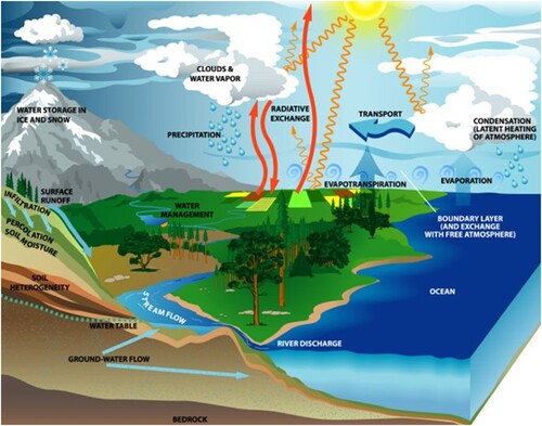
Essential Water Variables (EWVs) are those critical variables that are needed to meet the requirements of users for information to advance understanding of the global water cycle, support decision-making, and to ensure that the information needed to close the water budget on multiple scales is always available. They are essential because without them the reliability of water resource management decisions would be diminished and water prediction services and global water cycle research would not have ready access to reliable model initialization and validation data. is a schematic that outlines the global water cycle and the principal processes that drive it over most scales. These processes are important considerations in documenting the global water cycle and for determining which water variables are essential.
Figure 1. Schematic of the water and energy cycle in the Earth climate system (U.S. Global Change Research Program Citation2003).
The requirements for these variables were assessed through user needs surveys (Unninayar Citation2010) among two primary client groups: water managers and hydrological researchers. Their needs helped inform the list of EWVs developed for the GEOSS Water Strategy (see ). Many users benefit from the products that have resulted from research related to the water variables at different spatial scales. Some EWVs overlap with the Essential Climate Variables (ECVs) developed by the Global Climate Observing Systems (GCOS) in terms of the attribute measured, although the range of requirements for spatial and time resolution, refresh rates, latency, and accuracy tend to be different. For this reason, the Strategy promotes both the EWV and ECV perspectives. Combining geospatially consistent remote sensing data and high frequency in-situ measurements makes more reliable data products possible at all time scales.
Table 1. Primary and supplemental Essential Water Variables (EWVs) (adapted from GEO Citation2014). (* – Water Extent was not one of the original EWVs identified in 2014).
lists the primary and secondary EWVs. The GEOSS Water Strategy provides an assessment of gaps between the needs for optimum EWVs and current observational capabilities and makes a number of recommendations for ways to improve observational systems to support the acquisition of EWV data. In some cases, these recommendations relate to new sensors; while other recommendations address continuity in the measurements; or actions recommended to expand usage of the data.
The GEOSS Water Strategy focuses on the primary EWVs because there are other groups working on the supplemental EWVs and they are often addressed by other sectors and in general studies. Readers interested in more detail on space-based measurement systems are encouraged to refer to a recent CEOS handbook on Earth observations (e.g. CEOS Citation2018a), or a specialized textbook such as Liang and Wang (Citation2019).
The links between Water Management functions and the primary EWVs are listed in . As might be expected, these variables are needed for most aspects of water resource management, although the emphasis will vary from one geographical area to another, especially in the case of snow and glaciers. The table shows the adequacy of observational systems to provide coverage for water resource applications.
Table 2. Summary of primary Essential Water Variables (EWVs) with identifiable measurement options and demonstrated end-user applications/sectors. (The letter ‘Y’ in the first two columns indicates that current observational systems can provide what is needed, ‘P’ indicates the system only partially provides what is needed and ‘X’ indicates that the observational system needs major improvements to meet the information requirements of the specific water management issue.)
According to GEO surveys, precipitation is the most critical variable for analysis and planning when all sectors are considered (Friedl Citation2012). The GEOSS Water Strategy recognized that precipitation observational programs are better coordinated and the integration of precipitation data from different sources is more advanced than for other EWVs. Several precipitation products combine passively sensed microwave and actively sensed radar data from satellites, and, in some cases, in-situ measurements to produce high-resolution products.Footnote1 CEOS has successfully coordinated a precipitation constellation that harmonizes precipitation remote sensing capabilities with in-situ data contributions from countries around the world. Despite these achievements, securing the sustainability of these observational systems remains a concern because each satellite platform is expensive and national priorities for spending and scientific studies can change quickly.
Evaporation and evapotranspiration flux values are also widely used and can be derived from a combination of satellite and in-situ measurements. The GEOSS Water Strategy provides recommendations for improved standards for processing and archiving evapotranspiration data, facilitating the development of integrated products, and operationalizing evapotranspiration data as both an EWV and an ECV.
Satellite soil moisture measurements for the shallow soil layer near the surface need to be better integrated with in-situ measurements for estimates of soil moisture in deeper soil layers. To produce standardized products, observational capabilities and analysis procedures need to be improved to increase the useability of soil moisture data archives and products. Validation methodologies also appear to vary among space agencies.
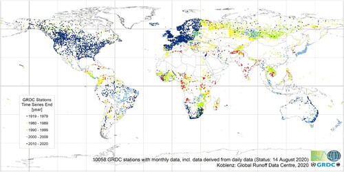
Streamflow and runoff data are collected by National Hydrometeorological Services and disseminated through the Global Runoff Data Centre (GRDC). Improvements are needed in the transfer of data to the GRDC to ensure timely updates to the GRDC archive. The GRDC provides a uniform interface for the international distribution of these streamflow and runoff data. shows where data are slow in finding their way to the GRDC, resulting in difficulties and delays in carrying out global assessments.
Figure 2. Distribution of stations that reported their data to the GRDC based on an August 2020 assessment. (Courtesy of Ulrich Looser, GRDC; personal communication).
The provision of operational groundwater measurements and continental water storage measurements pose other challenges. The Gravity Recovery and Climate Experiment and 2018 GRACE F-O (Follow-On) missions provide data for groundwater monitoring on long time and large space scales (seehttps://gracefo.jpl.nasa.gov/mission/overview/), but many operational water managers need higher spatial resolution data to address problems in specific aquifers. The Strategy focused on the needs for global standards for quality control and strategies such as data services to share in-situ groundwater data between countries.
Cryosphere variables (including snow cover, snow water equivalent, glaciers, frozen ground, and river and lake ice) are critical for monitoring climate trends and for predicting growing season water availability, particularly at mid – and high – latitudes. Data needs include improved satellite data coverage and more comprehensive in-situ snow measurements for estimating water availability, calibrating satellite snow water equivalent retrieval algorithms, and validating snowmelt models.
Water quality data are needed for environmental monitoring and water resources management. Many water quality variables, including chlorophyll concentrations, turbidity, and surface water temperatures, have attributes which are discernable by satellites. Examples include signals from optical and microwave satellites which provide data for estimating water quality parameter values and monitoring their changes with time. Providing operational water quality services will require the integration of satellite and in-situ data along with simulation models.
Water use is another EWV which has important implications for water planning but does not have values that are always standardized or even available. There is a need for a system that monitors quantities and changes of consumptive and non-consumptive water use. The variable is partially calculable through measurements such as evapotranspiration because many uses (such as domestic water use) are not monitored routinely, or the data are held by private agencies and not available for public use (Kim et al. Citation2009). A fully functioning water use monitoring system is envisioned to include process models operating in conjunction with measurement systems. A concerted research effort is needed to address this EWV.
Secondary EWVs such as water vapor, humidity, and cloud observations are considered essential for global water cycle understanding and for improving precipitation forecasts needed for estimating the future availability of water resources. The characteristics of these secondary EWVs are described in detail in the GEOSS Water Strategy Report (GEO Citation2014).
Developing appropriate policies and maintaining in-situ data networks that conform to international and global standards for data sharing are major challenges. The GEOSS Water Strategy’s recommendations related to in-situ data acquisition need to be addressed within a broad framework that considers national needs for data to support sustainable development targets and indicators, climate change accords, disaster risk reduction goals, resource development, industrial and domestic needs, and ecosystem requirements. More consistency in data policies is needed across national boundaries and across all EWVs to facilitate global assessments, research, and regional applications.
Many in-situ networks (e.g. precipitation, streamflow, water storage, groundwater, and water quality) are supported by national governments to meet the information needs for public safety, aviation, industrial development, and other specific local needs. Some scientists (Fekete et al. Citation2012) have been warning that there has been a serious worldwide decline of in-situ observational networks over the past two decades. This trend will continue unless in-situ observational networks come to be recognized as national priorities and nations allocate the funds needed to maintain and enhance these networks.
2.3.2. Theme 2: research and product development
Innovations for sensing the environment and for using these observations to support water management are needed. Many of the products considered in the GEOSS Water Strategy are data products for supporting research into tools and models to support water management. Specific needs include scientific advancements in satellite products that can better support land surface and hydrological modelling, individual and multi-sensor algorithms for improving the characterization of different land surfaces, and better soil texture maps and bathymetries for improving estimates of soil moisture and surface water storage. For example, Arrouays et al. (Citation2014) facilitated soil moisture assessments by developing a high-resolution global grid of soil properties. Other needs include scientific improvements in radiative transfer models for mapping soil moisture in the presence of vegetation and improved techniques for validating satellite-based soil moisture and groundwater measurements (Reichle Citation2017).
The same observational system can provide data for multiple EWVs. For example, innovative altimeter missions for water levels (Biancamaria, Lettenmaier, and Pavelsky Citation2016) can provide river discharge, water storage, and water extent. This latter variable has been adopted as a EWV since the Water Strategy was published.
The GEOSS Water Strategy anticipates that user demand will drive the product innovation process, but user engagement is needed to guide this process. The Strategy recommends that user needs should be assessed on a continuous, multilingual basis. The wide diversity of languages and formats for in-situ data available from different nations needs to be considered, and tools and applications that can access these data in different national information systems should be developed. The Strategy also recommends working with users to clarify the adequacy of existing products and services and to develop and establish new services. It is a scientific challenge to shift satellites and models from research environments to support long-term operations and homogeneous data records.
2.3.3. Theme 3: interoperability and coordination
Currently, data exchanges can be delayed or do not take place because systems are not interoperable (i.e. cannot seamlessly exchange data in consistent formats). System interoperability could assist in addressing user expectations for timely data access. In some parts of the world, data transfer systems are slow and inadequate because they rely on outdated Internet services. A high priority should be given to modernizing communication networks in the developing world and to promoting system interoperability.
Within GEO, the AquaWatch Initiative is taking the lead in developing an operational system for estimating water quality from satellite measurements. Interoperability and standardization are challenges for such a system especially when the possible role of in-situ data within this system is considered.
Interoperability among data and information systems facilitates water data handling from acquisition and quality assurance to data exchange, dissemination, and applications. Consistent standards for quality control of data are important for building user confidence in interoperable systems. In general, standardization is needed for the adoption of common protocols and procedures between different observing platforms and their data management and product delivery systems.
The GEOSS Water Strategy proposes to pattern the quality assurance of water data after approaches used for climate data. A generic process that enables the traceability of changes and includes independent levels of data product validation such as the procedure outlined in Zeng et al. (Citation2015) and Su et al. (Citation2017) is needed, perhaps based on Blockchain approaches. Validation is also necessary for land surface and hydrologic models, data assimilation systems, and satellite measurements. The collection of specialized validation data during intense observation periods to support the development of the new observational systems is very useful for developing robust algorithms.
Interoperability is the first step in a process leading to integration where the full system can be viewed and managed as an entity. Interoperability is being advanced by agencies within some nations to support integrated water management. While these actions were not direct responses to the GEOSS Water Strategy, they were supportive of the directions promoted by the Strategy. For example, the World Meteorological Organization (WMO) is developing regional prototype systems for the Arctic and the La Plata Basins that could serve as models for GEO’s efforts to develop regional information for water management. These efforts are being undertaken as part of WMO’s Hydrological Observing System (WHOS; https://community.wmo.int/activity-areas/wmo-hydrological-observing-system-whos) which supports the implementation of the GEOSS Water Strategy recommendations in the area of ontologies and regional applications. Land surface models and hydrologic models are used in Land Data Assimilation Systems and rely on regular observations as well as observations of more slowly changing land cover variables. The Global Energy and Water Exchanges (GEWEX) project.and NASA both support continued development of land data assimilation systems. The NASA LDAS (Jimenez et al. Citation2011) (see updates at https://ldas.gsfc.nasa.gov/data) produces high resolution land surface and lower atmosphere fields at resolutions smaller than 1 kilometer. These systems are capable of estimating missing data and, in some cases, estimating variables that are not directly measured (e.g. root zone soil moisture). NASA LDAS data products are available through the LDAS portal (https://ldas.gsfc.nasa.gov/data) and the NASA Giovani bridge between data and science (see: https://giovanni.gsfc.nasa.gov/giovanni/#service = TmAvMp&starttime=&endtime=&dataKeyword = GLDAS_NOAH025_3H_2_1).
Integration of data from models also can lead to useful data products that provide substantial benefits. Derived products for large areas are generally more accurate if they combine spatially consistent satellite data and high-frequency in-situ data to produce an integrated product, although there can be substantial scientific challenges in doing this. For example, GEWEX continues its work on land data assimilation through its global LDAS project (see gewex.org for details). However, in some areas, such as Alaska and the Canadian Arctic, where in-situ data are very sparse, models can produce fields of accumulated precipitation that can be as useful as those derived from in-situ data.
Within many countries, networks for specific variables are planned and managed independently so that synergies among data systems are minimal. Collaboration between the water and climate communities could be helpful to ensure that the development of EWV and ECV networks are harmonized. The Strategy suggests that the need for better coordination of the surface networks themselves requires an organization with broad coordination responsibilities.
The scientific community also needs the continuation and augmentation of in-situ data networks and associated data repositories. This community also has a role in helping to draw attention to the need to address the declining in-situ observational networks used for mapping and assessing the EWVs listed in . The Strategy points out that the value and uses of expanded EWV networks (including soil moisture and groundwater networks) need to be documented along with design options and assessments of trade-offs for consideration by decision-makers.
Close coordination among agencies and users in implementing existing and prototype or future observational systems is essential to ensure smooth transitions from one system to the next. This is particularly important when satellites and models are transitioned from research to long-term operations.
Nations should share their data with global data centers if they wish to fully engage the scientific community in achieving the SDG targets and in effectively coping with climate change. With the advent of ‘big data’ capabilities, citizen observations can provide additional coverage if they are incorporated into existing archives. A platform is needed to consolidate and quality control these observations and to merge them with observations collected by government agencies and other reliable sources.
2.3.4. Theme 4: capacity development and decision support
The GEOSS Water Strategy recognizes the need to train users on the use of Earth observation data so that the full benefits of satellites, in-situ networks, and models can be realized. The Strategy provides recommendations for facilitating this training internationally. In general, it advocates continuing and expanding the water community’s capacity development efforts currently taking place in Latin America, Asia, and Africa, but it also recommends building stronger linkages with regional GEO activities. While many of the barriers to capacity development are known, there are some infrastructure issues (e.g. internet services in Africa) that can only be effectively addressed in a multidisciplinary forum,
In view of this list of challenges presented in the GEOSS Water Strategy and summarized here in terms of the themes that were evident in that report, we now review what has been accomplished by the responses to the recommendations in the GEOSS Water Strategy, and give a preliminary assessment of the future of a GEO Water Strategy within the GEO framework.
3. Implementation of the geoss Water strategy
This section provides an overview of the actions taken in response to the GEOSS Water Strategy and its recommendations during the period from 2014 to 2022. It also introduces broader developments which contributed to addressing some recommendations.
3.1. Agencies and programs engaging in the implementation of the geoss Water strategy
After the publication of the GEOSS Water Strategy, GEO members were invited to contribute to its implementation. Progress in implementing the Strategy’s recommendations has come primarily through the voluntary efforts of agencies and programs within GEO member nations, and through the efforts of individual experts who have made proposals and taken actions to address specific recommendations. Implementation activities are carried out through non-binding commitments. In many cases, the agencies and programs have been making progress on their commitments, especially in cases where the agency benefits from the activity. Funding challenges, however, have limited progress in other areas.
The GEO IGWCO Community of Practice has monitored progress on these commitments and on occasion identified tasks where new leadership was required for a given activity or proposed adaptations to actions to address the recommendation more effectively. A summary of its most recent (March 2022) assessment of overall progress in implementing the GEOSS Water Strategy recommendations is shown by theme in . Actions on recommendations are classified as complete (no further action needed), in progress (they are still being worked on), or beyond GEO’s scope of expertise (no longer a priority). In this latter category is presented as ‘Beyond GEO.’
Table 3. Status of the implementation of the GEOSS Water Strategy recommendations by theme.
Overall, the GEO Water Strategy report contained more recommendations related to Themes 1 and 2 than for Themes 3 and 4. In the case of Theme 2 (Research and Product Development), few of the recommendations have been fully addressed and the theme has the highest number of recommendations that need to be addressed by groups outside GEO. Although Theme 4 (Capacity Development) has the fewest recommendations, a relatively large number of on-going activities address these recommendations, which indicates that the theme is progressing well. It should be noted that in some cases the assignment of a recommendation to a specific theme was subjective because some recommendations addressed more than one theme.
The three primary implementing organizations and programs carrying out these activities are described below. Other organizations and agencies that have assisted include the WMO, the Sustainable Water Futures Program, NASA, the National Oceanic and Atmospheric Administration (NOAA), JAXA, and the German Federal Hydrological Service.
3.1.1. GEO
Since its formation in 2005, the GEO partnership has grown to include 113 member nations and 143 participating organizations (as of August 29, 2022). These nations and institutions work together to coordinate their observational assets and to develop mechanisms for making their data and analysis tools available to users in many sectors. GEO and its satellite arm, CEOS, were engaged in the Water Strategy’s implementation from the outset. In addition to promoting its data management principles, GEO saw some benefit from the opportunities that the Strategy could provide for discussions with UN Water and its member agencies, as well as international research programs such as Future Earth.
GEO produces three-year work plans that outline each element’s goals and planned activities. The goals are achieved through voluntary contributions from its members. GEO has launched many services, including operational global services which are referred to as GEO flagships, and emerging services, known as GEO initiatives, because they have financial support and are moving toward a global service. GEO supports the implementation of the Strategy mainly through the GEO Global Water Sustainability (GEOGloWS (see https://www.geoglows.org/)) initiative, but also through AquaWatch, wetlands, and drought initiatives and, more recently, and in a more limited way through the GEO Earth Observations for the Water-Energy-Food Nexus pilot initiative.
Within GEO, GEOGloWS (see: https://www.geoglows.org/) is the lead initiative for addressing recommendations in the GEOSS Water Strategy. GEOGloWS’s mission of ‘connecting the demand for sound and timely environmental information to the supply of data and information about the Earth’s water system and to explore the science needed to achieve its goals,’ as outlined in Gutiérrez-Magness et al. (Citation2017), aligns well with the vision of the GEOSS Water Strategy.
AquaWatch (see https://www.geoaquawatch.org/), another water GEO initiative, addresses the Strategy’s recommendations in the area of water quality, To some extent, other implementing groups include GEO’s five regional caucuses, which consist of the five regional groups of member states, and the four related regional GEOs that serve as the implementing arm for the GEO caucuses. These caucuses provide a framework for cooperation among countries in each region in the development and use of Earth observations and related services. Readers wishing more detail on this structure should consult (https://www.earthobservations.org/documents/gwp20_22/gwp2020_summary_document.pdf)
Many national and international agencies in the U.S.A., Europe and Asia are engaged in GEOGloWS. GEOGloWS receives support from NASA, NOAA, the Centre National d'Études Spatiales (CNES) in France, the World Bank, and other U.S. and international agencies. NASA funded four major GEOGloWS projects, three of which supported the capacity development theme and one which supported the interoperability theme, along with many smaller projects supported through the NASA DEVELOP program.Footnote2 NOAA supports the initiative by providing the time and travel for its co-chair and provides services and products in the fields of hydrology and hydrometeorology. More recently, funded projects have also come from the CNES and the World Bank. GEOGloWS has strong ties to AmeriGEO (the Coordination Framework for GEOSS in the Americas) and has initiated many studies in Latin America that support the Strategy’s recommendations. Further details of GEOGloWS activities that support Themes 1, 3 and 4 of the Strategy are given in the GEOGloWS 2020–2022 (GEO Citation2019a) and 2023–2025 Work Plans (GEO Citation2022b).
AquaWatch (GEO Citation2019b) has also contributed by leading the implementation of actions related to water quality issues. In its efforts to develop an operational system for delivering near-real time water quality data (primarily satellite data) to users it has addressed Theme 3 recommendations. Although not featured in direct responses to the Strategy’s recommendations, the wetlands and drought initiatives have provided input to the formulation of the Strategy and contributed insights on options for advancing the Strategy’s concepts, assessments, and recommendations.
3.1.2. Committee on earth observation satellites (CEOS)
CEOS is a federation of national space agencies from around the world that coordinates civilian satellite Earth observation missions and develops new programs to promote Earth-observing satellites. It coordinates seven satellite constellations, including one for precipitation, and maintains working groups to support the implementation of capacity development and data democracy, climate observations, calibration and validation data and processes, disaster responses, and information systems and services.
In response to the GEOSS Water Strategy recommendations, CEOS undertook two reviews, both of which provided important insights on planning satellite systems for water applications. These two reviews (described in more detail in section 3.2.1) followed a preliminary assessment by CEOS of all the Strategy’s recommendations that were relevant to satellite observations. CEOS members chose two topics to study in detail based on their potential contributions to implementing the GEOSS Water Strategy and the level of interest of the CEOS member agencies in the recommendations.
3.1.3. Global terrestrial network – hydrology (GTN-H)
GTN-H is a joint program of WMO and GCOS led by the International Centre for Water Resources and Global Change (see https://www.waterandchange.org/en/). It coordinates a federation of global hydrometeorological data centers, many of which operate under the auspices of UN agencies. The data centers and networks archive many EWV data sets: some for climate purposes (e.g. precipitation and runoff), some for water quality monitoring (e.g. Global Environmental Monitoring System [GEMS] Water Data Centre), and most recently for water planning (e.g. by applying water use data from AQUASTAT, a UN Food and Agriculture Organization data center). lists the GTN-H data centers and their contact information.
Table 4. Global data centers federated under GTN-H and the data types they archive.
GTN-H continues to develop plans for addressing specific recommendations to support the implementation of the GEOSS Water Strategy by improving its data services, reviewing user requirements, increasing user engagement, advocating for open data and improved in-situ observation networks, documenting quality assurance procedures, inventorying data services, and facilitating open access to hydrological information.
3.2. Progress on the implementation of the themes
This section summarizes the actions that have been undertaken on a voluntary basis in response to the recommendations in the GEOSS Water Strategy, primarily by the three lead organizations and their initiatives and working groups. Each sub-section reviews the present status of implementation of one of the Strategy’s four themes.
It should be noted that the implementation of each of the themes involved user consultation. In addition to the user consultations in Theme 4 related to the needs for capacity building, similar consultations have occurred in each of the themes. In Theme 1, users provided their perspectives on which variables they felt were essential. In Themes 2 and 3, users were consulted through surveys on their satisfaction with existing products and their priorities for new products. Through the GEOGloWS flood forecasting project, users also were consulted on the ways in which streamflow forecast products could be customized to better meet their needs.
3.2.1. Implementation of improved data acquisition for essential water variables (Theme 1)
Under JAXA’s leadership, CEOS formed the Water Strategy Implementation Study Team (WSIST), which carried out in-depth feasibility studies for two GEOSS Water Strategy recommendations including an assessment of a water cycle satellite constellation, and a study exploring the potential for using satellites to monitor water quality. After completing these studies, CEOS also organized a ‘Freshwater from Space’ Workshop at the Delft Institute for Water in the Netherlands in November 2018 to consider how CEOS should address EWVs.
The WSIST reviewed the list of EWVs and chose six EWVs to address. They identified ways in which satellite measurements were or could be used to support various applications for six-frequently used EWVs. provides a summary of the findings of that analysis.
Table 5. Satellite-based Essential Water Variables and their applications in water resource management (adapted from CEOS Citation2017).
It is evident from that satellite data can provide data for many EWVs and that potential synergies exit among the observational systems. However, a more in-depth analysis would be required to identify which data sources are most useful and whether combinations of sensors are practical for a particular EWV. Although the specifications for critical EWVs are partially met at present by most measurement systems, the temporal and spatial resolutions need to be improved and data latency needs to be reduced to meet the requirements of some users for EWVs. Given the wide scope of user requirements, the Strategy recommends that new products be developed in conjunction with users to ensure they are ‘fit for purpose.’ More in-depth consultations with users related to specific details about their requirements will contribute to the design of future satellites at several different levels.
The CEOS WSIST reported on the potential benefits and synergies of using different sensor combinations to meet the water community’s observational requirements for six priority EWVs (CEOS Citation2017). One recommendation from the GEOSS Water Strategy dealt with the possibility of near-simultaneous measurement of terrestrial water cycle variables like a system for atmospheric water cycle variables that operated in 1990s and 2000s (Stephens et al. Citation2002). This approach, envisioned by the WSIST as a ‘Water Constellation’ was studied in some detail.
As part of this evaluation. different sensors were considered as part of a preliminary assessment for their potential contributions to a ‘Water Constellation.’ As an initial starting point, it was assumed sensors that measured a target EWV could be compatible with other sensors measuring the same target EWV (although some calibration adjustments would be necessary). For example, precipitation radars could be used to supply soil moisture data along with data from microwave imagers, thermal infrared radiometers and microwave sounders. The same microwave imager that provides soil moisture could also provide measurements for estimating precipitation and evapotranspiration. A table (not shown) was developed to summarize these and other cross-comparisons for the six EWVs that WSIST considered.
While this preliminary analysis uncovered many possible potential synergies, it lacked details about times and locations for measurements coming from each sensor for a particular area. Factors such as the difficulty in merging data from two or multiple sensor types for a target EWV were not reviewed in depth. For example, the rate of change with time for a target EWV must be considered to determine when a reading at one time can be merged or integrated with a second reading from a slightly different time. When merging data from satellites travelling on different trajectories, the spatial heterogeneity of the EWV must be considered. Furthermore, the ability to build on these synergies would require coordinated planning of new satellites to ensure there was coverage at the times and for the areas where targeted EWVs were most needed. CEOS concluded that a more in-depth study would be needed to determine the current and possible future mission and sensor scenarios that could benefit from building on these synergies to provide a more complete EWV monitoring system. CEOS concluded that it was premature to launch a terrestrial water constellation aimed at measuring multiple EWVs until more detailed assessments are completed.
The dimensions of water quality measurements are even more complex than those of water quantity. Optical sensors still need to play a central role in water quality monitoring systems even with the expected new applications of hyperspectral systems. The second in-depth CEOS study, entitled ‘Feasibility Study for an Aquatic Earth Observing System’ (CEOS Citation2018b) addressed these complexities. AquaWatch is developing a satellite-based information service similar to the type envisioned in this report. This approach could be strengthened by new missions, including a hyperspectral mission, to provide a more diverse set of observations for water managers concerned with water quality.
While AquaWatch continues to work toward the delivery of a satellite-based water quality information system, it has also worked with the United Nations Environmental Programme’s Global Environmental Monitoring System (GEMS) to coordinate issues involving the use of in-situ data in and with data from satellite systems. As a result of that collaboration, GEMS Water and AquaWatch have addressed the GEOSS Water Strategy’s recommendations for workshops on water quality issues and in-situ measurement techniques for water quality assessments. AquaWatch and GEMS Water also have produced a handbook of best practices for water quality measurements.
As part of its contributions to EWVs, GEOGloWS has taken the lead in refining the definition of EWVs and in developing the full implementation of the EWVs. It developed a plan for GEO to undertake the development of a consultative process to refine the EWV definitions and to outline a plan for a service to acquire and distribute EWV data. Based on their review, the preliminary criteria for an EWV would be its importance for water managers carrying out their resource management functions and for researchers undertaking water cycle research. This review and further discussions (available in part at https://www.geoglows.org/pages/workinggroup3) clarified that the criteria for EWVs should be variables and parameters that address ‘user’ defined critical requirements for one or more of the following:
Observational ‘monitoring’ of key elements of the global and regional/local water cycle,
Observations required by diagnostic and/or land surface/hydrological prediction models that are used to generate products for the end-user communities, and
Observations and model-derived variables and parameters required by users of water data/information products as applied to various operational water management decisions and inter-disciplinary decision support systems and tools.
Global water cycle research has benefited from the focus on EWVs bringing more variables to the analysis of the global water cycle. In particular, Godoy et al. (Citation2021) have traced the improvements in estimates of the global water budget components in which they show the advances made in the last decade.
There has been significant progress in the measurement of lake and reservoir levels and runoff/streamflow discharge based on data from newer small footprint altimeters. Studies by Berge-Nguyen et al. (Citation2021) and Machefer et al. (Citation2022) have advanced the capabilities of a community of users that is poised to exploit the capabilities of the SWOT mission. Experts anticipate that the recently launched (December 16,2022) SWOT mission will provide surface height data for large rivers that will be useful in estimating water depth and large river flows on a global basis, thereby reducing the impact of data distribution problems that have limited the full development of the GRDC archives. In addition to relying on the availability of new technologies, there are some discussions between GRDC management and experts from WMO and national hydrometeorological services that could lead to actions to reduce time lags in data transfers to the GRDC. Furthermore, the development of sophisticated hydrological models and improved satellite data for river stage height information has provided an alternative for regional and global water assessments.
Other areas where the use of EWVs has expanded since the completion of the GEOSS Water Strategy report have included NASA’s work in the areas of water and food security particularly in vulnerable regions such as Africa. As detailed in Arsenault et al. (Citation2020), the NASA Hydrological Forecast and Analysis System has been using satellite data on precipitation, soil moisture, and terrestrial water storage; and an ocean – land – atmosphere forecast system to produce early warnings of drought and resulting food insecurity in Africa. Another NASA system, the Landslide Hazard Assessment for Situational Awareness System, uses rainfall, snowfall, soil moisture, and snowpack mass to help estimate landslide hazards globally in the latitude band 60°N-S (Stanley et al. Citation2021). Hossain et al. (Citation2017) describes a system whereby satellite precipitation data is used in a crop model to provide irrigation advice to farmers through the Provision of Advisory for Necessary Irrigation system in the Indus Valley. Guidance on cold region precipitation can be found in a review by Romanov (Citation2016) of the ability to produce reliable multi-sensor products for snow and ice fields at 4 km resolution. While the breadth of these developments is impressive, efforts are needed to harvest the lessons, techniques and models that can bring single agency developments into a global context for the benefits of broader community of providers and users, as envisioned by the GEOSS Water Strategy.
Plans for developing an information system for EWVs have been delayed by COVID-19. Through their interactions with users, the GEOGloWS EWV activities and the GEO Earth Observations for the Water-Energy-Food Nexus Pilot Initiative have plans to contribute to understanding how different data types are used in decision-making.
The collection, archival, and dissemination of data for individual EWVs was also reviewed in response to recommendations in the GEOSS Water Strategy. Although most satellite data and data products are archived, gaps exist in the availability of some in-situ data from global data centers. Obtaining adequate funding to maintain in-situ networks for global water assessments and to ensure all collected data are made available through global data centers is a long-standing challenge. For example, although national in-situ soil moisture networks have not been fully integrated into a global network, an archive of data from national and regional networks has been developed (referenced in ). However, this archive is incomplete because some countries do not make their soil moisture measurements available; and international measurement and reporting standards remain to be developed. This archive, recently relocated to the German Hydrological Institute from the Technical University in Vienna, is now accepted as a GTN-H data centre.
The status of evapotranspiration derived from satellite data accounts for a gap between EWVs and ECVs. While evapotranspiration is recognized as an EWV and is widely used in irrigation management (Kisekka et al. Citation2009), it had not yet been used as an ECV. GCOS has relied on flux tower measurements and model results for its inputs on the ‘evaporation from land’ ECV (Miralles et al. Citation2020). The GEOSS Water Strategy recommendations led to a reconsideration of the decision to exclude satellite-based evapotranspiration measurements from the ECVs even though their values are generally similar to the ‘evaporation from land’ measurements. It is timely because more high-resolution land surface temperature measurements for evapotranspiration computations are now available from the new Landsat 9 satellite and the ECOSTRESS instrument carried by the International Space Station.Footnote3
Considerable progress has been made in groundwater and surface water storage measurements, although challenges remain. The GRACE and GRACE-F-O missions provide data on groundwater variations that have many applications (such as drought impact monitoring and assessments of changes in regional groundwater used for irrigation), demonstrating the value of these observations even though they have relatively low spatial resolution and long repeat intervals. The European Space Agency’s (ESA) Copernicus mission is helping to address this need for better resolutions. A comprehensive open archive of in-situ groundwater levels obtained from national archives would strengthen the ability to validate groundwater measurements derived from remotely sensed data. The UN’s International Groundwater Resources Assessment Centre, which undertakes regional and global assessments, could be a candidate for this role because it already collects such information for major aquifers and data from some nations willing to share groundwater data.
As noted above, in late 2022, CNES, NASA and other national space agencies have jointly launched the SWOT mission. It will provide calibrated global data needed for the analysis of water extent and river and lake stage on a global basis, thereby helping to fill another data gap in the EWVs.
Some individual GEO research initiatives focus on how citizen science can be used to address the gaps that exist in in-situ data sets. While there are encouraging developments in these publicly acquired data, issues of data consistency, standardization of approaches, and overall frameworks for managing these data systems still need to be developed.
3.2.2. Implementation of research and product development (Theme 2)
Some of the GEOSS Water Strategy recommendations in the areas of scientific research and product development went beyond the capabilities of the GEO Water community. New product development is a priority for each of the implementing organizations, but the developments of interest are focused primarily in areas that support each organization’s mission. GEO has an emerging central focus on new services and products and much of its software infrastructure will be used to facilitate these activities. However, given that many of the needs for research and new products identified in the GEOSS Water Strategy fall outside the remit of the implementing groups (i.e. the recommendation was for actions that were beyond the mandate and capabilities of GEO or ‘beyond GEO’), a concerted effort is planned to engage targeted organizations with the scientific and technical expertise and resources to address those recommendations that still require attention.
User requirements are not static and tend to be influenced by advances in instruments and related scientific capabilities. As new missions such as SWOT start providing data, the expectations and demands, and then the requirements, for higher resolution data related to surface water spatial extent are expected to increase. GEOGloWS has undertaken surveys with user communities in the Americas to obtain feedback on their satisfaction with current services, and their interest in new products, which will help update the information on user needs presented in the GEOSS Water Strategy. Once user requirements are further clarified, the holdings of global data centers should be assessed and new products identified and effort should be directed to developing protoypes. Data products that demonstrate the added value of openly shared in-situ observations are potentially important drivers for improving data acquisition at the global data centers and could encourage more investment in developing and maintaining observational networks.
GEOGloWS has overseen many capacity development efforts with support from the NASA DEVELOP program, which have led to a global streamflow prediction system and numerous services within the GEOGloWS flood protection framework. This development, which is being led by Brigham Young University (Nelson Citation2017), used a hydrologic model, global satellite data, and regional in-situ data to establish forecast services. Initially, this model was used to establish services in pilot areas, including Brazil, Nepal, the Dominican Republic, Thailand, and Argentina (Nelson, private communication). More recently, with the help of ESRI’s Living Atlas, the GEOSS Architecture Implementation Pilot Initiative, and collaboration with the European Centre for Medium to Long Range Forecasting (ECMWF), the Brigham Young University system has developed into an open access system (see http:hyroinformatics.byu.edu) that can be applied at any location around the globe. This system is expected to undergo further development as Brigham Young University takes the lead in developing the hydroinformatics component of the Cooperative Institute for Research to Operations in Hydrology.
The GEOSS Water Strategy highlights the need to integrate in-situ and space-based measurements. GTN-H is active in supplementing terrestrial observations with space-based satellite observations through its International Data Centre on the Hydrology of Lakes and Reservoirs. The Centre uses satellite observations including altimeter observations provided by the Laboratoire d’Études en Géophysique et Océanographie Spatiales’s Hydroweb (see http://ctoh.legos.obs-mip.fr/data/hydroweb). and in-situ measurements of streamflow and water storage in lakes and reservoirs, The Centre’s goal is to use these data to monitor water availability for many lakes around the world.
Data assimilation is used to produce products that integrate data from many different sources. For issues related to terrestrial water, land data assimilation systems are most useful. NASA continues to develop advanced data assimilation systems that utilize satellite and in-situ data along with more site-specific data on land cover and topography into a model framework to produce complete suites of high-resolution soil moisture and other land surface products.
The GEO Global Drought Information System initiative provides an example of how research, prediction capabilities, monitoring data, and modeling capabilities can be combined to identify droughts and classify their intensity. As outlined by Pozzi et al. (Citation2013), effective drought monitoring requires an ability to measure (or, in some cases, estimate) multiple stores of water simultaneously. Although the current Global Drought Information System provides a global framework, full interoperability is difficult to achieve because many nations and regions continue to prepare their inputs independently by using national analytical methods, national data sets, and drought criteria tailored to their region.
3.2.3. Implementation of interoperability and coordination (Theme 3)
Efforts related to interoperability and coordination are aimed at improving the accessibility of data and making it more useable. The GEOSS Water Strategy examined data management and data sharing policies and listed steps that could be taken at the national level and by international data centers to implement better procedures for reporting and disseminating data (GEO Citation2014). Obtaining sufficient calibration and validation data for water research remains a challenge because the data must meet accepted accuracy standards and be freely available. Small, instrumented basins and supersites are often the best sources of representative hydrologic data. These regular ongoing data collection activities are even more valuable when supplemented by periodic intensive field campaigns.
In response to concerns expressed in the GEOSS Water Strategy about the restrictions on data transfer practices by the Global Precipitation Climatology Centre and the GRDC, GTN-H indicated it had developed plans for a review of current practices as a first step in developing greater harmonization of the services provided by its data centers.
GEO has many common services that support the implementation of the GEOSS Water Strategy’s recommendations. Assistance from the GEOSS Architecture Pilot Initiative, which coordinates the development and testing of new data platforms, develops standards for metadata and data access mechanisms, and supports the development of near real-time data and data product delivery, could be very helpful for developing new integrated data systems. GEO has released a revised set of guidelines on how to apply GEO Data Management Principles covering the discovery, accessibility, and usability of data which also includes the ‘revsed GEO Data Sharing and Data Management Principles’ (available at https://gkhub.earthobservations.org/records/q9ds8-ahx82). Other GEO resources that support the implementation of the GEOSS Water Strategy include the GEOSS Platform (http://www.geoportal.org/) and the GEO Knowledge Hub (GKH). The platform includes many tools that could enable more data interoperability in GEOSS. The University of Tokyo’s Data Integrated Analysis System, NASA (Giovanni), and ESA (Copernicus) are examples of data services that provide users with access to a wide range of water data. An emphasis on the interoperability of such systems is important to ensure regional systems will be capable of combining different data sources to produce integrated data products.
Interoperability is needed across observation systems and sectors to provide comprehensive inputs to EWV data products and analyses, and across sectors to support integrated information systems for addressing complex issues such as the Water-Energy-Food Nexus at various scales. The GEOSS Water Strategy identifies ways in which interoperability could help improve the efficiency of data services. Interoperability among data systems increases the efficiency of prediction and data assimilation systems, enabling them to provide more timely and comprehensive results. To realize the benefits of better interoperability, gaps related to data sharing and the application of standards need to be addressed, especially for in-situ data.
Interoperability tends to focus on the exchange of data and generally requires compatibility of systems and the implementation of protocols. Adopting modern standards for open data stewardship and improved accessibility among national and global data centers are particularly important. Where interjurisdiction national issues are not involved, it may be possible to move beyond interoperability to integrated data services. GEOGloWS has been leading the way in developing international systems that bring data from different sources to produce products and services for a range of international users.
An extension of an interoperable system is an integrated system that brings the individual information systems under one management regime. Integrated information systems (Lawford Citation2019) could be designed to bring together data, data products, model outputs, and even socio-economic data to inform decision makers about a range of multi-sector issues. A GEOGloWS project has focused on data access among interoperable systems. This project provided software for accessing and using data products relevant to water security problems anywhere in the world.Footnote4 The system uses Tethys apps to help users navigate to the required data and to produce products and services for any location in the world The GEOGloWS/Brigham Young University global flood prediction system described in Section 3.2.2 is part of a larger effort focused on data access (Khattar et al. Citation2021). The flood prediction system uses a version of this system combined with a hydrologic model to provide a basic service platform that accesses satellite data, other global datasets, and local data sources as input to flood predictions.
Near-time model results are improved by access to short-latency data from multiple satellites and user access is improved when these observations are integrated into an operational system such as NOAA’s Weather Research and Forecasting prediction services. The GEOSS Water Cycle Integrator project at the University of Tokyo is another interoperable system that provides a comprehensive framework for moving data across sectors and includes a harmonized approach to collecting, analyzing, and interpreting water data (See www.wci.t.u-tokyo.ac.jp/en/). These systems produce real-time regional outputs for detailed analysis and predictions of water cycle variables and drought over North America, Africa, Asia, and in some cases the globe. Global systems such as the NASA Land Information System are also run routinely and need timely access to global data from interoperable systems. Recent reductions in the lag between the time when observations are taken and the time when high resolution land data assimilation products become available to users have increased the value of these products for decision making.
Since the GEOSS Water Strategy was published, GEO has announced several new initiatives that promote interoperability, including the GKH. Launched in 2019 by the GEO Secretariat, the GKH will provide comprehensive information and access to data for important applications of Earth observations so that anyone with minimal expertise could duplicate the process. The sharing of information through open access principles for data, procedures for data access, algorithms, analytical methods, models, and applications all promote more coordination among individual researchers. The GKH introduces procedures for sharing Earth observations more widely by providing protocols for registering and sharing data across disciplines. It also sets standards for transforming Earth observation data into knowledge-based services for evidence-based decision-making. The GKH provides links to the Earth observation data archives, as well as related research papers and reports describing analysis techniques and methods, software algorithms and cloud computing resources to enable users to process data and satellite imagery using widely accepted models and analysis tools thereby assisting them in producing the desired results for their application (see https://www.earthobservations.org/documents/pb/me_202002/PB-16-07_Draft%20Implementation%20Plan%20for%20the%20GEO%20Knowledge%20Hub.pdf). Opportunities are being sought to codify appropriate knowledge from responses to the GEOSS Water Strategy recommendations into some applications for the GKH.
3.2.4. Implementation of capacity development and decision support (Theme 4)
The GEOSS Water Strategy contributes to improving water security worldwide by developing capacity for using data and information to facilitate more effective water management. This includes facilitating data accessibility globally. As discussed earlier, enabling data interpretation by decision-makers helps make water management more equitable world-wide. The goal is also advanced by supporting the convergence and harmonization of observations, the transfer of new analysis techniques and the knowledge of how to use them, and the development of interoperable systems for use by experts in regions lacking training and access to adequate knowledge infrastructure to enable them to support water management more effectively.
Although water problems have many facets that are dependent on cultural, social, and economic settings, there are also many commonalities in how these problems could be addressed. Therefore, facilitating a collaborative exchange of ideas, methods and implementation technologies would help ensure more equity in the services provided across regions as well as creating more opportunities for cross-region learning. The GEOSS Water Strategy envisioned that new capacity development activities would build on past collaborations and partnerships, create new ones, make better use of GEO and national agency infrastructure and programs, increase user engagement in the design and production of new products, and harmonize capacity development across water activities around the globe. An important aspect of achieving this goal involves enhanced collaboration and knowledge sharing among water-related capacity development efforts in different regions. Water-related capacity development should account for regional differences regarding climate, physiography, and differences in the capacity to provide data services and water use accounting that exist due to the level of industrial development, and differences in languages and cultures. GEO recognized some of these differences when it adopted regional groups for the Americas, Africa, Commonwealth of Independent States, Europe, and the Asia-Oceania region.
Information infrastructure put in place globally by agencies from the developed world is another asset for international capacity development. For example, the NASA/United States Agency for International Development’s (USAID) SERVIR program disseminates NASA products through its five active regional hubs. Two of these hubs are in Asia (Nepal and Thailand), two are in Africa (Kenya and Nigeria), and one is in South America (Colombia). These hubs provide satellite-based Earth observations, imaging and mapping data, geospatial information, predictive models, training, and science applications to help improve regional and local environmental decision-making. GEO water-related capacity development activities have benefited from the support provided by these hubs.
GEO water activities use the internet extensively for training purposes. In addition to the examples listed in the following regional discussions, AquaWatch has hosted a series of webinars on key developments that support its plan for an operational water quality service based on satellite data for the world’s inland lakes and coastal waters. GEOGloWS hosts training and development webinars and in-person training in Spanish and English. As noted in the GEOSS Water Strategy, as this wide array of webinars and on-line training opportunities expands, more coordination is needed. This coordination could be improved if some organization hosted a web-based clearinghouse for information on water-related training and webinar opportunities.
The following paragraphs provide a summary of GEO water-related Capacity Development in different regions.
Capacity development in the americas
GEOGloWS, in collaboration with AmeriGEO, has developed capabilities that have contributed to water management across the Americas. Based on support from NASA, NOAA, USAID, and the World Bank, GEOGloWS has developed a strong capacity development component that benefits countries throughout Latin America. Some of these activities have been supported by the NASA DEVELOP program, which funded many short-term GEOGloWS projects in the Americas. DEVELOP projects are useful in providing new understanding, assessing the feasibility of conducting larger scale studies, exploring new applications through demonstration projects, and developing web portals. As a result of these projects, many water managers in Latin America can now readily use different types of satellite data in their water management decisions. These opportunities have been expanded by bilingual (English/Spanish) GEOGloWS training programs and the support of NASA’s Applied Remote Sensing Training Program (ARSET).
Capacity building in Asia:
The Asian Water Cycle Initiative (AWCI), coordinated by the International Centre for Water Hazard and Risk Management and the University of Tokyo, addresses many water-related capacity development needs in Asia. During the early stages of the Strategy’s implementation and under the leadership of the University of Tokyo and JAXA, AWCI worked with the Japan International Cooperation Agency and Asian Pacific Network to develop in-country and on-line training programs and workshops at the University of Tokyo. Since 2018, AWCI has focused on national governmental services with support from the Asian Pacific Network. Under AWCI’s leadership, national plans have been implemented for water data integration for Myanmar, Indonesia, the Philippines, and Sri Lanka. These plans include adapting and implementing national platforms using water data to address resilience and disaster reduction in ways that are tailored to each nation’s infrastructure and technical capabilities (UN High Level Panel on Water Citation2018). These developments utilize information systems such as the University of Tokyo’s Data Integrated Analysis System among others.
AWCI continues to address research needs related to floods, droughts, climate change adaptation, and, where appropriate, water quality. It remains committed to platforms and studies that share data, models, experiences, and knowledge among the participant organizations. During the COVID-19 pandemic, AWCI frequently implemented e-learning as part of its capacity development activities.
NASA has supported GEOGloWS projects aimed at developing techniques and tools to improve decision-making for water resources in South Asia. Reporting on a study that explored the use of Earth observations to improve the management of irrigation water reservoirs in the upper Indus River Basin, Hill et al. (Citation2020) demonstrated that improved snowmelt estimates could provide more accurate predictions of flows into the reservoirs storing water for irrigation for the following summer. Water management problems along the Mekong River are complicated by the impacts of upstream developments on downstream flows. According to Kim et al. (Citation2019) integrated multi-satellite products combined with tools for water management by agencies in Viet Nam and Cambodia can be used by agencies in the Lower Mekong River Basin to monitor surface water storages. Other related capacity development infrastructure and activities in Asia include NASA/USAID SERVIR hubs in Nepal and Thailand, ESA’s Dragon project in China, and national programs such as Japan’s national capacity development activities.
Capacity development in Africa:
Many water-related capacity development projects in Africa build upon TIGER-NET, a project initiated by ESA that has supported applications of satellite data to water management and resource management problems in Africa over the past two decades. ESA remains supportive of building capacity in Africa. GEOGloWS has worked with the CNES Space Climate Observatory to provide climate adaptation schemes over major African basins. In collaboration with the CNES hydrological programme and GEOGloWS, data are being applied to manage the Congo-Oubangui-Sangha Basin in Africa. The International Centre for Water Hazard and Risk Management, in collaboration with the African Water Cycle Coordination Initiative, is undertaking an assessment of the Niger River Basin. Two NASA/USAID SERVIR hubs are supporting capacity building in eastern and western Africa by facilitating the distribution of data and data analysis tools in Africa.
Available training resources
Readers who are interested in the GEOSS Water Strategy and affiliated training programs mentioned here are encouraged to explore the following websites:
NASA’s ARSET program: https://appliedsciences.nasa.gov/what-we-do/capacity-building/arset/arset-water-resources-trainings
GEOGloWS: https://training.geoglows.org/en/latest/index.html
ESA’s Research and User Support: https://rus-copernicus.eu/portal/
NASA/USAID SERVIR Workshops and Training (Global): https://servirglobal.net/Global/Our-Work/Capacity-Building/Training-Workshops
3.3. Next steps in implementation
To track the status of actions related to the recommendations in the Water Strategy report, the IGWCO Community of Practice has been maintaining a rolling review of developments and issuing a report semi-annually for interested GEO members. These reports are available through the IGWCO Community of Practice. In some cases, the developments are in direct response to the GEOSS Water Strategy, or they were undertaken for other reasons but still provide a positive response for an issue raised in the Strategy. In cases where the groups addressing a recommendation have achieved their objectives and addressed all (or most) of the concerns that gave rise to the recommendation, further actions are no longer being tracked. In other cases, the progress is slower than expected and more effort is needed. There also are many recommendations where the issues would be best addressed by groups outside the GEO water community and efforts are being made to engage these other groups.
GTN-H continues to work with its data centers to address data service issues for in-situ data. It is working to advance its plans to carry out a review of services and data exchange practices in its data centers. If funding is available, GTN-H also plans to develop a discovery service for available station data and data products for its partner networks to facilitate access to data and encourage users to further develop new applications and products.
GEOGloWS will continue to develop initiatives to support capacity development, to advance the implementation of the EWVs, and to develop new applications of Earth observation data that support public policies and the program’s overall goals. GEOGloWS plans to continue to expand its extensive capacity development efforts for the Americas into Africa and Asia.
Although the number of recommendations from the GEOSS Water Strategy that were addressed and completed in the first three years of implementation was impressive, the rate of project completions has decreased in the past three or four years. For example, after the first three years of the Strategy, CEOS had completed its commitments in leading responses for the satellite aspects of GEOSS Water Strategy. The decrease in the number of recommendations being addressed in recent years could also reflect a tendency to place more value on service development than on coordination, or that new technologies may have decreased the requirements for some of the solutions recommended in the Strategy, or that the emergence of new non-GEO water strategies attracted more commitment from those who initially focused on the GEOSS Water Strategy. There are many reasons to believe the time has come to revisit the Strategy and incorporate the latest developments, opportunities and needs into a revised statement or a new Water Strategy, and to use this effort to reinvigorate the GEO Water community. In summary.it appears that the time has come to either update and revise this GEOSS Water Strategy or develop a new strategy that possibly incorporates new technologies such as Artificial Intelligence applications and other innovations.
At this stage of the Strategy’s implementation, the IGWCO Community of Practice has identified four priorities for more attention in the next year namely 1) development of the EWV concept and the design of a supporting open data system to make these data readily available globally; 2) development of a plan for a comprehensive system for monitoring water use; 3) depending on the availability of funding, modernization of data handling procedures within the GTN-H global data centers responsible for in-situ EWV data collection and services, and 4) explore the possible expansion of the communication of water applications through the GEO Knowledge Hub.
The IGWCO Community of Practice continues to work with the GEO Secretariat to explore opportunities to engage other groups such as UN-Water and WMO (including the World Climate Research Programme and GCOS), in addressing some of the unassigned recommendations.
The reliance of the implementation of the GEOSS Water Strategy on voluntary help at every stage explains why some projects have support and proceed quickly while others without sustained funding are slower to advance. GEOGloWS has been successful in garnering and mobilizing resources and has the potential to contribute more broadly to the GEOSS Water Strategy recommendations, assuming suitable projects are identified. In addition, AquaWatch and, to a lesser extent, the GEO wetlands, and drought initiatives, supplement GEO’s overall contribution to the implementation of the Strategy. Some future support is also anticipated for the GTN-H to strengthen its contributions to climate data services. A joint approach to ECVs and EWVs could be useful in encouraging progress at GTN-H’s global data centres.
Considering changing scientific and societal requirements for observation-based water information, the availability of new technologies that could provide a larger range of variables at higher resolution, and expectations for a more interdisciplinary approach to GEO Water initiatives in the coming years, there is an urgent need to produce an updated version of the GEOSS Water Strategy for the 2025–2035 time period. This new strategy and descriptive document should identify and explore the implications of emerging policy developments and technologies for water, and present the major opportunities and challenges. An updated Strategy is seen as essential for building stronger links with public policies such as climate change and the Sustainable Development Goals and to further engaging and expanding the community interested in addressing these opportunities and challenges from a water perspective. The new document should also recognize the changing focus of GEO, which tends to be shifting from data base development to the development and implementation of services using Earth observations.
4. Summary
The GEOSS (Group on Earth Observations System of Systems) Water Strategy focuses on the science and practices of Earth observations and their integration into water management through the GEO (Group on Earth Observations) framework. It was based on the most urgent and pervasive concerns arising from discussions at regional workshops held on three continents and from the personal experiences of its lead authors. In this article, the progress in implementing the Strategy has been reviewed against its four over-arching themes: Improved Data Acquisition for Essential Water Variables, Research and Product Development, Interoperability and Coordination, and User Engagement and Capacity Development. The advances that have occurred in these major themes have come primarily through the efforts of the three principal implementation groups namely the GEO partnership, CEOS (Committee on Earth Observation Satellites), and GTN-H (Global Terrestrial Network Hydrology), have been summarized. The Strategy follows the GEO policies for open data and analysis tools promoting greater use of observations through full and open access to data and open software tools. Groups, initiatives, and individuals within interested organizations and programs responded to the recommendations with planned sets of activities for addressing them. However, gaps still exist. For example, more attention should be given to the Strategy’s recommendations related to the need for increased user engagement and the broader application of modern tools for in-situ data acquisition, processing and dissemination.
The GEOSS Water Strategy sets out a path for advancing water-related observational and information services. It envisions a process of systematic transformation within the programs led by GEO members and participating GEO organizations, through open data practices including advances in data integration, and through new collaborations such as the UN SDGs (Sustainable Development Goals) (especially Goal 6 on water), disaster risk reduction, climate change, the Water-Energy-Food Nexus, and ecosystems. The concept of integration is advanced by producing EWV data products, developing information platforms and multi-sectoral data services, and utilizing data assimilation frameworks.
Within the bounds of a voluntary program, the GEOSS Water Strategy recommendations were successfully implemented in a number of areas across the GEO Program. GEOGloWS (GEO Global Water Sustainability) made substantive contributions through the innovative use of government programs and infrastructure. GEO AquaWatch has continued to make progress on its goal of developing a satellite-based water quality monitoring system and has addressed several of the Strategy’s recommendations in the process. Other GEO initiatives have had good intent but on occasion have been limited by insufficient resources to fully address the Strategy’s recommendations.
CEOS, the space arm for GEO, has addressed the satellite-related recommendations in the GEOSS Water Strategy. CEOS was especially helpful in the first three years of the Strategy’s implementation by providing assessments and perspectives on the status of existing and planned satellite developments.
GTN-H provides an important link with GCOS (Global Climate Observing System) and WMO, and could play a central role in the EWVs by developing data exchange policies and protocols in cooperation with GEO. The funding situation for GTN-H is complex because it is a coordination mechanism and must balance its resource commitments and responses for the GEOSS Water Strategy activities with other high-profile demands, including climate change monitoring. Future GTN-H contributions will depend to some degree on their success in obtaining contributions from other organizations.
At this stage of its implementation, it is clear that the GEOSS Water Strategy has been successful in a number of areas, including:
In Theme 1, the CEOS assessment of the synergies between satellite sensors for measuring EWVs. This study identified ways in which water-related sensors could be organized to provide better-coordinated EWV measurements. AQUASTAT joined the federation of GTN-H data centres, thereby strengthening opportunities to engage in supplying water use data to support water security projects.
For Theme 2, the development of the GEOGloWS flood prediction system was scaled up from regional pilots to function as global system. This approach provides a model for how other national or regional applications could be scaled up and integrated with global forecast systems.
For Theme 3, an interoperable system for the exchange of data and analysis has been developed and implemented through a NASA-funded GEOGloWS research project to make GEOGloWS projects and other water-related projects and services more efficient.
For Theme 4, GEOGloWS and the AWCI (Asian Water Cycle Initiative) agreed to work collaboratively to seek ways to harmonize their capacity development activities and share their experiences. Also, through the GEO Water initiatives, web-based training programs have advanced significantly, allowing for greater access to relevant national training and water research. programs. The strong collaboration between GEOGloWS and AmeriGEO (Coordination Framework for GEOSS in the Americas) with NOAA (National Oceanic and Atmospheric Administration) and NASA (National Aeronautics and Space Administration) support has led to innovations that have strengthened water management in Latin America.
The following challenges slowed the implementation of the GEOSS Water Strategy:
The concept of the co-generation of products requires further encouragement and nurturing because the co-generation approach is not part of the training and skill set of many creative academic scientists and engineers.
Many organizations are fully engaged with their own agendas and do not have the capacity to take the lead in research and product development activities that may not be deemed to be within their organization’s priorities. It may be difficult to engage organizations to take on responsibility for these projects without being able to provide them with some tangible incentives.
Lack of funding hampers proposed studies by GEO initiatives that supported the GEOSS Water Strategy and for GTN-H efforts to carry out assessments and upgrades of data services in support of water services.
In conclusion, the authors believe that over the last decade the GEOSS Water Strategy has influenced many developments related to the applications of and technical support for the acquisition and application of Earth observations to water management and water research. It has provided motivation and guidance through voluntary and best-effort projects and encouraged related activities by a number of organizations. Given the evidence, the authors consider that the Strategy, a form of ‘grassroots’ effort for addressing issues related to many aspects of data services for the water sector, is a useful way for individual experts and small groups with different levels of influence to communicate their needs and expectations to large international programs, national services, and space agencies. In addition to obtaining useful ideas and feedback on data needs and services, the broad inputs from organizations and individuals with widely varying responsibilities, and from different nations to this Strategy, have helped to increase awareness of the value of open water data, analysis tools, and information systems, and the great potential for using water-related data and information to support better decision-making in water management and more efficient water research.
In conclusion, the authors would like to note that the GEO Community addressing water wishes to be informed of any other actions being undertaken by any organization that helps support the recommendations in the GEOSS Water Strategy. The IGWCO COP continues to invite reports and information on relevant actions through its affiliated GEWEX web site at https://www.igwco.org.
Acknowledgements
The authors are grateful for the support of NASA, JAXA, and NOAA in the development of the GEOSS Water Strategy and its implementation. The efforts of Andrée-Anne Boisvert in assisting in editing this article is also gratefully acknowledged. In addition, the support of the GEO Secretariat and CEOS in facilitating the implementation a number of the Strategy's recommendations is appreciated. While the authors who prepared this report were all intimately involved with the Strategy and its implementation, they would like to acknowledge the contributions, advice and support of dozens of other scientists who worked to provide advice and to act on the Strategy’s recommendations.
Disclosure statement
No potential conflict of interest was reported by the author(s).
Data availability statement
Information about this study is freely available from the lead author, or from other authors with expertise in specific areas, or from the IGWCO Community of Practice, and will be made available on request. The actual data from specific studies reported here are retained by the responsible organizations employing the investigators. and in most, if not all cases, the organizations treat the data as open access data.
Notes
1 ‘Precipitation constellation’ refers to a coordinated set of satellites which provide similar data at different times of the day to give frequent high-resolution precipitation products (see https://ceos.org/ourwork/virtual-constellations/p-vc/ for more details).
2 DEVELOP is a NASA-sponsored program that integrates NASA's Earth observations to help address the challenges of environmental change and improve life on Earth (see develop.larc.nasa.gov for more details).
3 ECOSTRESS refers to NASA’s ECOsystem Spaceborne Thermal Radiometer Experiment which is being carried on the International Space Station. It acquires thermal data from around the world to measure the temperatures of plants and assess their demands for water (see https://ecostress.jpl.nasa.gov/ for more details).
4 ‘Tethys apps’ is a platform for application development that is based on a Python Language Software Development Kit designed to lower the barrier to geospatial web app development. (see: https://www.tethysplatform.org/)
References
- Alcamo, J., H. Grassl, H. Hoff, P. Kabat, F. Lansigan, R. Lawford, D. Lettenmaier, et al. 2005. The Global Water System Project: Science Framework and Implementation Activities. Global Water System Project International Project Office, 76 pp., Bonn, Germany.
- Arrouays, D., M. G. Grundy, A. E. Hartemink, J. W. Hempel, G. B. M. Heuvelink, S. Y. Hong, P. Lagacherie, et al. 2014. “Global Soil Map: Towards a Fine-Resolution Global Grid of Soil Properties.” Advances in Agronomy 125: 93–134. doi:10.1016/B978-0-12-800137-0.00003-0.
- Arsenault, K. R., S. Shukla, A. Hazra, A. Getirana, A. McNally, S. V. Kumar, R. D. Koster, et al. 2020. “The NASA Hydrological Forecast System for Food and Water Security Applications.” Bulletin of the American Meteorological Society 101: E1007–E1025. doi:10.1175/BAMS-D-18-0264.1.
- Berge ́-Nguyen, M., J. F. Cretaux, S. Calmant, S. Fleury, R. Satylkanov, D. Chontoev, and P. Bonnefond. 2021. “Mapping Mean Lake Surface from Satellite Altimetry and GPS Kinematic Surveys.” Advances in Space Research 67: 985–1001. doi:10.1016/j.asr.2020.11.001.
- Biancamaria, S., D. P. Lettenmaier, and T. Pavelsky. 2016. “The SWOT Mission and its Capabilities for Land Hydrology.” Surveys in Geophysics 37 (2): 307–337. doi: 10.1002/2014GL062764.
- Committee on Earth Observation Satellites (CEOS). 2017. Water Constellation Feasibility Study. Water Strategy Implementation Study Team, 99 pp.
- Committee on Earth Observation Satellites (CEOS). 2018a. Satellite Earth Observations in Support of the Sustainable Development Goals, edited by M. Paganini, I. Petitieville, S. Ward, G. Dyke, M. Steventon, J. Harry, and F. Kerblat, 108. European Space Agency. Retrieved from http://www.eohandbook.com/sdg
- Committee on Earth Observation Satellites (CEOS). 2018b. “Feasibility Study for an Aquatic Earth Observing System.” In Prepared by a Water Strategy Implementation Study Team, edited by A. Dekker, and N. Pinnel, 199. Published by the Commonwealth Scientific and Industrial Research Organization, Australia.
- European Union. 2008. Environmental Quality Standards Applicable to Surface Water. Retrieved from https://eur-lex.europa.eu/EN/legal-content/summary/environmental-quality-standards-applicable-to-surface-water.html.
- Falkenmark, M., and G. Lindh. 1976. Water for a Starving World, 204. Boulder, CO: Westview Press.
- Fekete, B. M., U. Looser, A. Pietroniro, and R. D. Robarts. 2012. “Rationale for Monitoring Discharge on the Ground.” Journal of Hydrometeorology 13 (6): 1977–1986. doi:10.1175/JHM-D-11-0126.1.
- Friedl, L., et al. 2012. GEO Task US-09-01a: Critical Earth Observation Priorities, Summary of Results. 2nd ed. Retrieved from https://sbageotask.larc.nasa.gov/US-09-01a_SummaryBrochure_v2.pdf.
- Godoy, M. R. V., Y. Markonis, M. Hanel, J. Kyselý, and S. M. Papalexiou. 2021. “The Global Water Cycle Budget: A Chronological Review.” Surveys in Geophysics 42: 1075–1107. doi:10.1007/s10712-021-09652-6.
- Group on Earth Observations (GEO). 2005. Global Earth Observation System of Systems (GEOSS): Ten-Year Implementation Plan. Reference Document GEO 1000R, 209. The Netherlands: ESA Publications Division.
- Group on Earth Observations (GEO). 2014. The GEOSS Water Strategy: From Observations to Decisions, edited by R. Lawford, 255. Tokyo: Japanese Aerospace Exploration Agency.
- Group on Earth Observations (GEO). 2019a. GEO Work Programme 2020-2022: GEO Global Water Sustainability (GEOGloWS). Geneva, Switzerland, 22 pp.
- Group on Earth Observations (GEO). 2019b. GEO AquaWatch Initiative Implementation Plan, Version 2.1, 24pp. (Retrieved from https://www.earthobservations.org/documents/gwp20_22/AQUAWATCH.pdf).
- Group on Earth Observations (GEO). 2022b. GEO Work Programme 2023-2025 Application: GEO Global Water Sustainability (GEOGloWS). Geneva, Switzerland.
- Group on Earth Observations GEO Blue Planet Initiative. 2022a. Ocean and Coastal Observations for Policy Makers and Decision Makers, https://geoblueplanet.org/.
- Gutiérrez-Magness, A., B. Doorn, R. Lawford, C. Garay, N. Jones, I. DeLoatch, and E. Frazier. 2017. GEO Global Water Sustainability (GEOGLOWS): Earth observations for sustainability in water management in the Americas and around the world. Proceedings of the XVI World Water Congress, Cancun, Quintana Roo, Mexico, May 29-June 2, 2017, 10 pp.
- Hill, A. F., K. Rittger, T. Dendup, D. Tshering, and T. H. Painter. 2020. “How Important Is Meltwater to the Chamkhar Chhu Headwaters of the Brahmaputra River?” Frontiers in Earth Science 8 (81), doi:10.3389/feart.2020.0008.
- Hossain, F., N. Biswas, M. Ashraf, and Z. Ahmad. 2017. “Growing More with Less Using Cell Phones and Satellite Data.” Eos 98. doi:10.1029/2017EO075143.
- Integrated Global Observing Strategy – Partnership (IGOS-P). 2004. The Integrated Global Water Cycle Observations Theme for Monitoring our Environment from Space and from Earth. ESA, The Netherlands: 100 pp.
- International Council for Science, and International Social Science Council. 2015. Review of the Sustainable Development Goals: The Science Perspective, 92. Paris: International Council for Science.
- Jimenez, C., C. Prigent, B. Mueller, S. I. Seneviratne, M. F. McCabe, E. F. Wood, W. B. Rossow, et al. 2011. “Global Inter-Comparison of 12 Land Surface Heat Flux Estimates.” Journal of Geophysical Research, 116, D02102. doi:10.1029/2010JD014545.
- Khattar, R., R. Hales, D. P. Ames, E. J. Nelson, N. L. Jones, and G. P. Williams. 2021. “Tethys App Store: Simplifying Deployment of Web Applications for the International GEOGloWS Initiative.” Environmental Modelling and Software 146: 16 p. doi:10.1016/j.envsoft.2021.105277.
- Kim, D*, H. Lee, C.-H. Chang, D. D. Bui, S. Jayasinghe, S. Basnayake, F. Christie, and E. Hwang. 2019. “Daily River Discharge Estimation Using Multi-Mission Radar Altimetry Data and Ensemble Learning Regression in the Lower Mekong River Basin.” Remote Sensing, 11, 2684. doi:10.3390/rs11222684.
- Kim, Y., T. Schmid, M. B. Srivastava, and Y. Wang. 2009. BuildSys ‘09: Proceedings of the First ACM Workshop on Embedded Sensing Systems for Energy Efficiency in Buildings, November 2009, Pages 1-6. doi:10.1145/1810279.1810281.
- Kisekka, I., K. W. Migliaccio, M. D. Dukes, J. H. Crane, and B. Schaffer. 2009. Evapotranspiration-Based Irrigation for Agriculture: Implementing Evapotranspiration-Based Irrigation Scheduling in Agriculture. AE458. Gainesville: University of Florida Institute of Food and Agricultural Sciences. https://edis.ifas.ufl.edu/ae458.
- Kundzewicz, Z. W., L. J. Mata, N. W. Arnell, P. Döll, B. Jimenez, K. Miller, T. Oki, et al. 2008. “The Implications of Projected Climate Change for Freshwater Resources and Their Management.” Hydrological Sciences Journal 53 (1): 3–10. doi:10.1623/hysj.53.1.3.
- Lawford, R. G. 2019. “A Design for a Data and Information Service to Address the Knowledge Needs of the Water-Energy-Food (W-E-F) Nexus and Strategies to Facilitate its Implementation.” Frontiers in Environmental Science 7 (56), doi:10.3389/fenvs.2019.00056.
- Lawford, R., J. Bogardi, S. Marx, S. Jain, C. Pahl-Wostl, F. Lansigan, C. Ringler, and F. Meza. 2013b. “Basin Perspectives on the Water-Energy-Food Security Nexus.” Current Opinion in Environmental Sustainability, S1877–3435(13)00153. doi:10.1016/j.cosust.2013.11.005. COSUST 5: 607–616.
- Lawford, R., A. Strauch, D. Toll, B. Fekete, and D. Cripe. 2013a. “Earth Observations for Global Water Security.” Current Opinion in Environmental Sustainability 5 (6): 633–643. doi:10.1016/j.cosust.2013.11.009
- Liang, S., and J. Wang, eds. 2019. Advanced Remote Sensing: Terrestrial Information Extraction and Applications, 1010. Chicago: Academic Press.
- Machefer, M., M. Perpinyà-Vallès, M. J. Escorihuela, D. Gustafsson, and L. Romero. 2022. “Challenges and Evolution of Water Level Monitoring Towards a Comprehensive, World-Scale Coverage with Remote Sensing.” Remote Sensing 14: 3513. doi:10.3390/rs14153513.
- Mays, L. W. 2007. Water Resources Sustainability. McGraw Hill (New York) and WEF Press (Alexandria, Virginia). 330 pp.
- Miralles, D. G., W. Brutsaert, A. J. Dolman, and J. H. Gash. 2020. “On the use of the Term 'Evapotranspiration'.” Earth and Space Science Open Archive, doi:10.1002/essoar.10503229.1.
- Mishra, B. K., P. Kumar, C. Saraswat, S. Chakraborty, and A. Gautam. 2021. “Water Security in a Changing Environment: Concept, Challenges and Solutions.” Water 13 (4): 21 p. 10.3390/w13040490.
- National Academies of Sciences, Engineering, and Medicine. 2018. Thriving on Our Changing Planet: A Decadal Strategy for Earth Observation from Space, 701. Washington, DC: The National Academies Press. doi:10.17226/24938
- Nelson, J. 2017. (GEOGloWS) WG #4 Data Dissemination, Community Portal, Capacity Building and Communication. Presentation to the GEO Plenary Side event on GEOGloWS and the harmonization of GEO Water Activities. GEO Plenary, Washington D.C.
- Pozzi, W., J. Sheffield, R. Stefanski, D. Cripe, R. Pulwarty, J. V. Vogt, R. R. Heim Jr, et al. 2013. “Toward Global Drought Early Warning Capability: Expanding International Cooperation for the Development of a Framework for Monitoring and Forecasting.” Bulletin of the American Meteorological Society 94: 776–785. doi:10.1175/BAMS-D-11-00176.1.
- Reichle, R. H., et al. 2017. “Assessment of the SMAP Level-4 Surface and Root-Zone Soil Moisture Product Using In Situ Measurements.” Journal of Hydrometeorology 18: 2621–2645. doi:10.1175/JHM-D-17-0063.1.
- Romanov, P. 2016. “Global 4-km Multisensor Automated Snow/Ice Map (GMASI) Algorithm Theoretical Basis Document.” NOAA NESDIS Cent. for Sat. Appl. and Res, 61pp. http://www.star.nesdis.noaa.gov/smcd/emb/snow/documents/Global_Auto_Snow-Ice_4km_ATBD.pdf.
- Stanley, T. A., D. B. Kirschbaum, G. Benz, R. A. Emberson, P. M. Amatya, W. Medwedeff, and M. K. Clark. 2021. “Data-Driven Landslide Nowcasting at the Global Scale.” Frontiers in Earth Science 9 (640043): 15. doi:10.3389/feart.2021.640043.
- Stephens, G. L., D. G. Vane, R. J. Boain, G. G. Mace, K. Sassen, Z. Wang, A. J. Illingworth and the CloudSat Team, et al. 2002. “The CloudSat Mission and the A-Train: A New Dimension of Space-Based Measurements of Clouds and Precipitation.” Bulletin of the American Meteorological Society 83 (12): 1771–1790. doi:10.1175/BAMS-83-12-1771
- Su, Z., W. Timmermans, Y. Zeng, J. Schulz, V. John, R. Roebeling, P. Poli, et al. 2017. “An Overview of European Efforts in Generating Climate Data Records.” Bulletin of the American Meteorological Society 99 (2): 349–359. doi:10.1175/BAMS-D-16-0074.1.
- UN High Level Panel on Water. 2018. Making Every Drop Count - An agenda for water action. Retrieved from https://www.unwater.org/un-world-water-development-report-2021-valuing-water/).
- Unninayar, S., et al. 2010. GEO Task US-09-01a: Critical Earth Observations Priorities for Water Societal Benefit Area (SBA), 77. Hampton, VA: NASA Langley Research Center. Available at http://sbageotask.larc.nasa.gov/Water_US0901a-FINAL.pdf
- U.S. Global Change Research Program (USGCRP). 2003. Our Changing Planet: The Fiscal Year 2003. Washington, D.C.: USGCRP. 124 pp.
- Vörösmarty, C., P. Green, J. K. Salisbury, and R. B. Lammers. 2000. “Global Water Resources: Vulnerability from Climate Change and Population Growth.” Science 289: 284–288. doi:10.1126/science.289.5477.284.
- Vörösmarty, C., D. Lettenmaier, C. Leveque, M. Meybeck, C. Pahl-Wostl, J. Alcamo, W. Cosgrove, et al. 2004. “Humans Transforming the Global Water System.” Eos, Transactions American Geophysical Union 85 (48): 509, 513–514, 520. doi:10.1029/2004EO480001
- Vörösmarty, C., C. Pahl-Wostl, S. Bunn, and R. Lawford. 2013. “Global Water, the Anthropocene and the Transformation of a Science.” Current Opinion in Environmental Sustainability 5: 539–550. doi:10.1016/j.cosust.2013.10.005
- Zeng, Y., Z. Su, J.-C. Calvet, T. Manninen, E. Swinnen, J. Schulz, R. Roebeling, P. Poli, et al. 2015. “Analysis of Current Validation Practices in Europe for Space-Based Climate Data Records of Essential Climate Variables.” International Journal of Applied Earth Observation and Geoinformation 42: 150–161. doi:10.1016/j.jag.2015.06.006.