
 ?Mathematical formulae have been encoded as MathML and are displayed in this HTML version using MathJax in order to improve their display. Uncheck the box to turn MathJax off. This feature requires Javascript. Click on a formula to zoom.
ABSTRACT
Rich observation data generated by ubiquitous sensors are vital for wetland monitoring, spanning from the prediction of natural disasters to emergency response. Such sensors use different data acquisition and description methods and, if combined, could provide a comprehensive description of the wetland. Unfortunately, these data remain hidden in isolated silos, and their variety makes integration and interoperability a significant challenge. In this work, we develop a semantic model for wetland monitoring data using an agile and modular approach, namely, wetland monitoring ontology (WMO), which contains five modules: wetland ecosystem, monitoring indicator, monitoring context, geospatial context, and temporal context. The proposed ontology supports the semantic interoperability and integration of wetland monitoring data from multiple sources, domains, modes, and spatiotemporal scales. We also provide two real-world use cases to validate the WMO and demonstrate the WMO’s usability and reusability.
1. Introduction
Climate warming and extreme hydrological events are threatening the sustainability of wetlands (Sun et al. Citation2022). Given this situation, research communities have striven to develop and implement monitoring systems that aim to build a wetland digital twin by integrating all-area, all-weather, and all-factor observation data acquired by efficient sensing technology. Due to the maturation and widespread usage of various monitoring sensors, a vast quantity of wetland monitoring data has been produced, effectively resolving the challenge of acquiring wetland data from the source (Chen, Fang, and Xiao Citation2023). However, interpreting, integrating, searching, and reusing monitoring data requires more context semantic information that raw observation results do not provide (Janowicz et al. Citation2019).
With a rapid increase in monitoring data, the current system lacks the ability to automatically associate and integrate relevant information from a large number of data to form semantic descriptions (Ding, Zhu, and Lin Citation2014), which results in monitoring data often hidden in isolated silos that do not integrate knowledge to infer the evolution of wetland geographical phenomena and support decision-making (Vilches-Blázquez et al. Citation2014). Typically, wetland monitoring data contains no machine-readable or human-readable semantics. Machines can parse the wetland monitoring data but not understand it (even domain experts). A semantic gap exists in monitoring data from multiple sources, leading to serious data heterogeneity problems, hindering efficient interoperability between ubiquitous sensors (Durbha et al. Citation2009). Therefore, the task of coherently combining heterogeneous wetland monitoring data raises significant challenges.
Ontology, a key technology of the Semantic Web, is a very promising approach to reduce the semantic gap between data. Ontology is widely used to resolve the challenges of heterogeneity, interoperability, and complexity of data in integrated domains such as geospatial (Sun et al. Citation2019), urban (Kuster, Hippolyte, and Rezgui Citation2020), and disaster (Scheuer, Haase, and Meyer Citation2013). The numerous applications in a variety of domains show that ontology is a useful format for representing data because it can transform data from machine-readable to machine-understandable (Dubey, Patel, and Jain Citation2021). As a top-tier technology, ontology integrates, shares, and uses data to unify data models, improve data quality by metadata, support data mining and analysis, and promote knowledge sharing. The ontology should thus improve data interoperability and provide more reliable and effective support for data application and decision-making; it should also produce good results for wetland monitoring.
However, wetland ecosystems are complex, with strong spatiotemporal heterogeneity (Malekmohammadi and Jahanishakib Citation2017), complex underlying surface conditions, and strong interactions between hydrological relationships (Wang et al. Citation2023). As a result, few attempts have been made to develop ontologies dedicated to wetland monitoring, despite the immense importance of wetland monitoring and the need to support interoperable data. Thus, the current ontology cannot fully address the following challenges:
Wetland monitoring data encompass a wide range of disciplines, including ecology, biology, hydrology, geographic information systems, remote sensing technology, and environmental science. These disciplines have different concepts, terms, and expressions, so the terms and expressions used in different disciplines may differ, producing a semantic gap. Therefore, we must establish consistent standard terms and expressions for data in different disciplines and strengthen the integration of interdisciplinary data.
Wetland monitoring data are collected from heterogeneous sensors and are multimodal (Chen, Fang, and Xiao Citation2023). Different types of sensors can collect wetland information from different angles and record data in different forms, forming a multimodal wetland monitoring data set. For example, temperature sensors produce time-series data, and remote sensing satellites produce spectral-image data.
Wetland monitoring data include a diverse spatial scale. Due to different monitoring methods and objectives, wetland monitoring data are characterized by a diversity of spatial scales. Data acquired over different spatial scales must be interpreted differently to analyse and evaluate wetlands. Microdata provides local details of wetlands, whereas macro data reveal the overall pattern and processes of ecosystem succession. Therefore, more complex and comprehensive analysis tasks of all data services must be integrated under a unified spatial reference.
Wetland monitoring data cover a diverse temporal range. Some wetland monitoring tasks are continuous, and some are intermittent. Therefore, analysing monitoring data requires that the stability and consistency of the data be considered to ensure the comparability and reliability of the results.
To overcome these challenges and fill this research gap, this study aims to build a wetland monitoring ontology (WMO) that can integrate static and dynamic monitoring data with spatiotemporal information in a uniform way and support the great variety of applications of wetland protection and assessment. This article makes the following main contributions:
Provide a common semantic framework to combine data from multiple, heterogeneous sources and thus support data interoperability. WMO is iterative and modular, which aligns with upper-level ontologies and reuses existing domain ontologies. Therefore, it is highly extensible and reusable. We thus design the ontology to gain a deeper insight and make better decisions based on wetland monitoring data.
WMO-synthesized indicators and formalized cause-and-effect relationships between indicators for wetland monitoring are introduced by the drivers-pressures-state-impact-response framework (DPSIR), which helps to unify the concept and terminology of wetland monitoring indicators, thus improving the consistency and comprehensibility of the ontology. In addition, the WMO partitions wetlands into a hierarchical set of cells based on a discrete global grid system (DGGS), which explicitly and seamlessly characterizes parts of wetlands with multiple spatial resolutions.
The rest of this paper is organized as follows: Section 2 describes background concepts and gives a literature overview. Section 3 details the methodology we have followed for building the WMO. Section 4 presents the WMO and details each module. Section 5 describes the application of the ontology in two real use cases. Section 6 discusses the usefulness of WMO and compares it with related ontologies. Finally, Section 7 presents the concluding remarks.
2. Related work
Turning wetland monitoring data consistently and systematically into valuable and actionable knowledge is an ongoing challenge for the research community and stakeholder organizations. The ontology is considered as the cornerstone of the semantic web (Mishra and Jain Citation2020) and has become one of the most important areas of interest in geographic information science (Bouyerbou, Bechkoum, and Lepage Citation2019).
2.1. Ontology: definition, advantage, classification and methodology
The term ‘ontology’ originally comes from the field of philosophy, where it refers to a theory used to describe the origin or matrix of the beings in the world (Guarino, Oberle, and Staab Citation2009). Computer scientists adopted this term in the field of artificial intelligence to describe knowledge that can be represented computationally. Numerous definitions of ontology have been given in many relevant studies, but Gruber’s definition (Gruber Citation1993) – an ontology is a formal, explicit specification of a shared conceptualization – is the most widely accepted and quoted. We strongly agree with Studer’s interpretation (Studer, Benjamins, and Fensel Citation1998) of the Gruber definition: the term ‘formal’ means that the contents of the ontology are machine-readable; the term ‘explicit’ means that the concept in the ontology should be clearly defined without ambiguity; the term ‘shared’ means that the knowledge represented by the ontology is not the statements of individuals but is accepted by the community; and the term ‘conceptualization’ means that an ontology is a conceptual model abstracted from the objective world.
Ontology is a formal specification of domain knowledge and has seen use in many practices, bringing several advantages (Booshehri et al. Citation2021): First, ontology provides a common knowledge vocabulary for a field, enables researchers and computing agents to better understand domain knowledge, and supports knowledge-based artificial intelligence applications (Rožanec, Blaž, and Mladenić Citation2022). In addition, ontology reuses and modularizes domain knowledge and uses the inference engine to discover new knowledge, which improves the problem-solving capability of the decision-support system (Scheuer, Haase, and Meyer Citation2013). Moreover, an ontology is not only a logic-based organizational structure for knowledge but also a data model that can be applied to knowledge graphs. Therefore, an ontology can manage isolated data and improve the findability and reuse with the transformation, link, and fusion of massive multisource heterogeneous data (Wu et al. Citation2022; Masmoudi et al. Citation2020).
Most researchers classify ontologies as ‘upper-level,’ ‘domain,’ and ‘application’ (as shown in ). An upper-level ontology – also known as a top-level ontology or foundational ontology – describes general concepts and provides a guide for building domain ontology. The concepts in different domains can be related through a unified upper-level ontology to achieve cross-domain exchange, integration, and reuse of knowledge (Garcia et al. Citation2020; Masmoudi et al. Citation2020). Thus, upper-level ontology leads to excellent reusability and abstractness but must be combined with domain ontology to better exploit its capabilities. Several well-known upper-level ontologies exist: Basic Formal Ontology (BFO) (Otte, Beverley, and Ruttenberg Citation2022), Suggested Upper Merged Ontology (Pease, Niles, and Li Citation2002), and Descriptive Ontology for Linguistic and Cognitive Engineering (Borgo et al. Citation2022).
Figure 1. Overview of a hierarchical collection of ontologies.
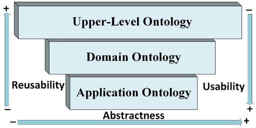
Domain ontologies describe domain-specific knowledge by extending an external upper-level ontology. Application ontology is developed for a specific application with domain knowledge and problem-solving methods. Generally, domain ontology can be reused in various application scenarios in this domain. However, application ontologies are application driven and have low reusability. The ontology proposed herein is a domain ontology. Considering that BFO follows the principles of ontological realism, fallibilism, and adequatism (Otte, Beverley, and Ruttenberg Citation2022), has a small volume but high generalization, and is proven in many domains, we use it herein as the upper ontology of WMO.
Building ontologies has become an engineering activity as the concept and scope of ontology become clearer, thus prompting the proposition of numerous ontology-development methodologies (Suárez-Figueroa, Gómez-Pérez, and Fernández-López Citation2015). Traditional methodologies, such as Ontology Development 101 (Noy and McGuinness Citation2001), METHONTOLOGY (Fernández-López, Gómez-Pérez, and Juristo Citation1997) and On-To-Knowledge (Staab et al. Citation2001), serve to build single ontologies from scratch. However, the application range of wetland monitoring data is very wide, and the original version of an ontology is difficult to achieve overnight and needs to be constantly revised and improved in a practical application. ‘Agile’ and ‘modular’ are state-of-the-art ideas in ontology methodologies. ‘Agile’ is achieved through rapid iterations and continuous feedback, which constantly improves the design and implementation of the ontology (Peroni Citation2017) to meet the changing needs of wetland monitoring data and application scenarios. ‘Modular’ involves dividing the ontology into multiple interrelated sub-modules, constructing ontologies for each sub-module separately, and ultimately forming a complete domain ontology that includes multiple sub-modules. The idea of modularity provides an easy way to avoid developing large ontologies and facilitates modifications to adapt the ontology to new purposes (Shimizu, Hammar, and Hitzler Citation2022). In this light, the present study uses an agile modular methodology to develop a wetland monitoring ontology.
2.2. Domain ontologies related to wetland monitoring
In previous studies, ontology has seen widespread use in various domains. In the following, we present some remarkable ontologies in three fields related to wetland monitoring: environment, monitoring, and geospatial.
Several ontologies exist where concepts of environment ontology are defined. The Semantic Web for Earth and Environmental Technology (SWEET) is a well-known ontology in Earth and environmental sciences that contains over 7000 concepts and basically covers the major definitions of Earth sciences (Raskin and Pan Citation2005). The SWEET, however, only defines the overall conceptual framework but gives no detailed semantic description of specific concepts and their interrelationships. The environment ontology (ENVO) is also a prestigious community ontology comprised of terms referring to environmental types (e.g. Earth, ecosystems, waters), environmental characteristics (e.g. temperature, humidity, light), environmental pollutants (e.g. chemical substances, microorganisms), and environmental events (e.g. natural disasters, climate change) (Buttigieg et al. Citation2013). The ENVO is a more detailed conceptualization and covers all the classes defined by the SWEET and that are useful for wetland monitoring (Rubí and Gondim Citation2021). By linking and integrating with other ontologies, the ENVO is used in multiple fields, including environmental monitoring (Masmoudi et al. Citation2020) and biodiversity research (Zárate et al. Citation2020).
The semantic sensor network (Compton et al. Citation2012) and the sensor, observation, sample, and actuator (SOSA) (Janowicz et al. Citation2019) ontologies provide a framework for managing, querying, combining, and reasoning sensors the sensor-related monitoring data in a machine-readable format. The SOSA was released as a lightweight core library for the semantic sensor network and allows context to be monitored through classes, such as observation, observable property, measure, and result. Therefore, the SOSA sees use in a wide range of fields, including smart cities (Rubí and Gondim Citation2021), environmental monitoring (Masmoudi et al. Citation2020), and climate science (Wu et al. Citation2022). These fields can achieve interoperability and integration of sensors and data through the use of SOSA ontologies, thus better supporting various applications of monitoring data. However, the SOSA does not enable a unit of measure. For this reason, most applications use the quantities, units, dimensions, and types schema (Mekonnen et al. Citation2022) to specify units of measurement and to ensure consistency in the representation of physical quantities across different sensors and observations.
The adoption of semantic technologies in geoscience has been an active research area in recent years (Ma Citation2022). In the geoscience context, the semantic representation of geospatial information is the focus of this type of research. The GeoSPARQL (Perry and Herring Citation2023), proposed by the open geospatial consortium, is a standardized implementation for representing and querying geospatial data. GeoSPARQL provides a set of classes and properties for representing discrete vector geospatial data, such as points, lines, and polygons. A typical case is the application of GeoSPARQL to urban ontology or urban knowledge graph construction (Kuster, Hippolyte, and Rezgui Citation2020), which can well describe urban objects, such as traffic lights (points), roads (lines), and green spaces (polygons). However, in the context of wetland monitoring, we focus on a continuous geographical space, which cannot be simply expressed by points, lines, and polygons. Therefore, a majority of wetland monitoring data cannot be integrated into a unified geospatial reference with the current architecture of GeoSPARQL. Fortunately, the DGGS provides a potential solution, which may provide a more flexible representation of space. In the field of digital Earth, the DGGS is a framework for dividing the surface of the Earth into a nonoverlapping grid of cells based on the concept of tessellation, which is proposed as an effective way to integrate disparate geospatial data into a common spatial reference system (Li and Stefanakis Citation2020; Hojati et al. Citation2022). In another perspective, DGGS is stratified to divide Earth’s surface, so that is its ability to handle monitoring data at different resolutions. Based on this, the DGGS can group continuous wetland monitoring data of varying scale into discrete spatial objects by subdividing the wetland surface into a limited number of discrete regions (Rawson, Sabeur, and Brito Citation2022).
2.3. Summary
On the one hand, wetlands are special transitional ecosystems between terrestrial ecosystems and aquatic ecosystems, and exist in complex ecological conditions, with structures and functions showing both terrestrial and aquatic characteristics (Kovács, Horion, and Fensholt Citation2022). Wetlands are highly hydrologically dynamic ecosystems and vulnerable to human impacts (Malekmohammadi and Jahanishakib Citation2017). Therefore, monitoring wetlands is different from monitoring general ecosystems, requires a multi-disciplinary approach that integrates ecological, hydrological, and social aspects. On the other hand, wetland monitoring is an activity that systematically measures the composition, processes, and functions of wetland ecosystems at specific times and locations, which differs from general surveillance in that there is a specific reason and method for collecting data or information (Davidson and Finlayson Citation2007). Despite the numerous studies relating to monitoring ontologies, only a few recent publications address the question of wetland monitoring. Ultimately, this is because wetland monitoring is a knowledge-intensive domain that requires multidisciplinary integration and collaborative research. The WMO ontology aims to close this gap by improving the integration of wetland monitoring data and enhancing the generation of knowledge-driven approaches in wetland question analysis.
3. WMO development methodology
Building an ontology that can adapt to a growing multisource variety of heterogenous wetland monitoring data, whereas supporting various use-case scenarios is a complicated process. Based on the comparative analysis of the various ontology-development methodologies mentioned in section 2.1, given the wetland context and considering the continuous increase in monitoring data brought about by the rapid development of sensors, any wetland monitoring ontology will have to be constantly updated. To satisfy the principle of extensible ontology and avoid large-scale reconstruction of the wetland monitoring ontology during future updates, this study introduces the concepts of agility and modularity in the construction of the wetland monitoring ontology. Therefore, we adopt herein the ‘agile methodology for developing ontology modules’ (AOM) (Masmoudi et al. Citation2020) to develop the WMO. shows the workflow along with the phases of WMO development life cycle, which includes four phases: exploration, planning, module development, and release.
Figure 2. Methodology for developing WMO ontology.
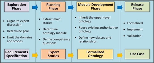
During the exploration phase, ontology engineers and domain experts determine the requirements for the wetland monitoring ontology through several discussions. The goal of WMO is to build a formal, shared, and semantically consistent ontology that can describe and organize the knowledge and concepts involved in wetland monitoring based on the depth, breadth, and complexity of wetland monitoring data. This should produce a unified management, query, and integration of wetland monitoring data, improve the reusability and interoperability of the data, support complex wetland analysis tasks, enhance the intelligence of wetland monitoring systems, and promote the sustainable use and development of wetlands.
In the planning phase, we extracted four main stories to define the perimeter of the WMO based on the requirements. The four main stories are (1) the wetland ecosystem conditions story, which includes wetland materials, geographical objects, and ecological processes, (2) the monitoring indicators story, which includes human factors and natural factors as well as meteorological, plant, and hydrological factors, (3) the monitoring story, which includes sensors and data, and (4) the spatiotemporal-conditions story.
During the module-development phase, we identified five modules of WMO based on four stories. Each module focuses on some competency questions (CQs) related to wetland monitoring, described in detail in section 4. Each module is aligned with the upper ontology BFO to ensure interoperable reuse and integration of WMO with other ontologies. In addition, a highly recommended good practice in ontology construction is to reuse existing ontologies (Arvor et al. Citation2013). Some existing ontologies that contain knowledge and concepts related to the module's goals are used directly or partially modified and extended to avoid duplicate ontology-building efforts and improve knowledge reuse.
During the release phase, we build the interaction relationship between modules and integrate each sub-module to form a complete wetland monitoring ontology. Later, the formal model is developed using the Web Ontology Language (OWL2, http://www.w3.org/TR/owl-ref/). Then, according to the WMO ontological scheme, all wetland monitoring data are converted into the resource description framework, which enables a SPARQL (https://www.w3.org/TR/rdf-sparql-query/) for knowledge querying about both terminology (TBox) and assertions (ABox). Finally, the WMO is applied to the real-use case of wetland monitoring to investigate its application.
4. Wetland monitoring ontology
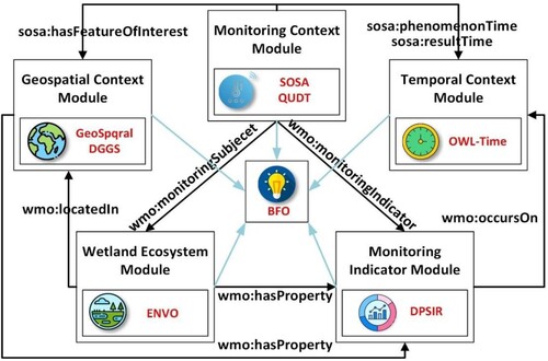
Wetland monitoring ontology (WMO) is a comprehensive ontology composed of term hierarchy facets that cover core elements of ecosystem, monitoring indicators, and monitor context in wetlands, and a term that can effectively formalize the spatiotemporal knowledge of phenomena and entities in wetlands. As shown in , WMO consists of five modules linked to each other through relationships. In the following, we define the five main modules of WMO and highlight the most important classes and relationships of the module.
Figure 3. The five modules of WMO and the relationship between modules.
4.1. WMO wetland ecosystem module
As the CQs in show, in a wetland monitoring ontology, we must first determine what a wetland ecosystem is and what to monitor. A well-structured and comprehensive taxonomy of coverage is essential for the usability of the ontology. The ecosystem module is the foundation of the WMO and focuses on the taxonomy of wetland classification and wetland structure ().
Figure 4. Partial view of WMO wetland ecosystem module.
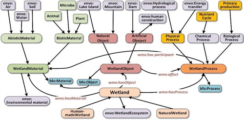
Table 1. CQs related to ecosystem module.
Wetland classification mainly refers to relevant concepts and hierarchical relationships in Ramsar Classification System for Wetland Type and National Standard for Wetland Classification in China. Wetlands are classified into two basic systems, namely: artificial wetlands and natural wetlands. And each system is further classified into sub-systems. For example, natural wetlands can be classified into coastal wetlands, lacustrine wetlands, marshy wetlands, and riverine wetlands. It is worth noting that a wetland individual can belong to a variety of wetland types, such as Poyang Lake, while meeting the characteristics of lacustrine wetlands, marshy wetlands, and riverine wetlands.
The wetland ecosystem module also establishes the basic description of the concept and structure of each element of wetland monitoring and describes the relationship between the elements. Wetland is a transitional zone between land and water, so it has rich terrestrial and aquatic wildlife resources, giving it incomparably ecological diversity, species diversity, and biological productivity. It is difficult to describe all the constituent elements of a wetland ecosystem, so the WMO combines group intelligence, reusing ENVO ontology. The core monitoring terms include wetland material, wetland object, and wetland process. These are defined below:
Wetland material. The most basic monitoring element of the wetland monitoring system is the component of the wetland object and the participant of the wetland process. The relation between monitoring and materials is evident: The class aligns with the
in BFO and is classified as abiotic materials and biotic materials and reuses classes defined under
Wetland object. Several physical objects are also important concerns for wetland monitoring. These physical objects can directly or indirectly affect some phenomena in wetlands. For example, hydraulic projects affect hydrological processes and ecological processes in wetlands. Wetland objects include both artificial and natural objects in WMO and align with the
Wetland process. In contrast with material and object, the complete and comprehensive understanding of critical processes in wetland ecosystems may not be simple. The materials and objects in a wetland play different roles in different processes. Wetland processes are changes or reactions that occur naturally within wetland ecosystems (Davis and Brock Citation2008). The class
4.2. WMO monitoring indicator module
In the ecosystem module, we standardize to the extent possible the components of the wetland ecosystem, which are the main subject of the monitoring system. The monitoring-indicator module should answer the CQs in . However, the monitoring variables for each sensor are indicators that are closely related to each component of the ecosystem, such as the area and depth of water. In fact, it is hard to select monitoring indicators. At present, most monitoring systems select indicators based on which indicators can be monitored, not on which indicators should be monitored. The WMO aims to be a framework for a broader set of scenarios and must conceptualize the indicators that should be monitored with a meaningful organizational form.
Table 2. CQs related to monitoring indicator module.
The DPSIR framework is useful for differentiating and integrating wetland monitoring indicators to better understand the relationships between indicators (Ficken et al. Citation2022; Oesterwind, Rau, and Zaiko Citation2016). We developed the monitoring indicator module within the DPSIR framework to express key variables and causal relationships from diverse monitoring data. (). Each indicator is classified under the DPSIR module adapted from (Oesterwind, Rau, and Zaiko Citation2016).
The
The
The
The
The
Figure 5. Partial view of WMO monitoring indicator module.
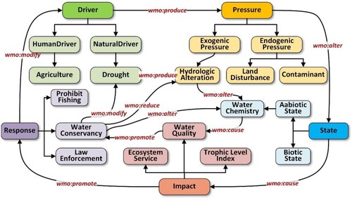
The key strength of the DPSIR is that it identifies the relationships in wetland monitoring data by establishing a chain of causal links from driver indicators that produce pressures to alter the state of the wetland, thereby causing certain impacts that promote various responses. The main causality is defined in the WMO as the following axioms:
(1)
(1)
(2)
(2)
(3)
(3)
(4)
(4)
(5)
(5)
4.3. WMO monitor context module
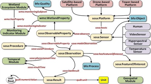
Searching, reusing, integrating, and analysing monitoring data requires more than just numerical records; it also requires extracting information about the relevant characteristics of the sensors, such as the characteristics of the temperature sensors, the location, and the sampling strategy used. Frequent incorrect data sampling, missing values, and untrustworthy data are common in pervasive observations because sensors are deployed in distant, unfriendly, and harsh environments. Given the growth in the number and variety of sensors and observation activities involved, data discovery for wetland monitoring is an increasingly complex task. The monitor context module is certainly the core of the WMO and describes how sensors monitor wetlands; it should be able to answer the CQs in .
Table 3. CQs related to monitor module.
The SOSA has numerous successful applications in environmental monitoring, as described in section 2. The classes and properties contained in SOSA ontology are reused and extended according to the domain characteristics of the wetland monitoring in this module ().
Figure 6. Partial view of WMO monitoring context module.
4.4. WMO geospatial context module
Given the variety of monitoring data produced by sensors, a common geospatial semantic framework is required to enable integration. Because the wetland area is inherently continuous there are an infinite number of location at multiple resolutions (Rawson, Sabeur, and Brito Citation2022). A wetland monitoring system needs to monitor each location. Therefore, it is difficult but necessary to characterize wetland location in the WMO. The DGGS provides a multiscale congruent geography, which is an efficient solution for integrating multilayer spatial data by accommodating different spatial scales and positional uncertainties (Goodchild Citation2018). Thus, WMO reuses the GeoSPARQL (prefix: geo) standard and introduces H3, which is an efficient 16-level (resolution from 0 to 15) DGGS, to expand its ability to formally describe different locations at different levels of spatial resolution.
To address the spatial aspect CQs related to the geospatial in , three concepts related to DGGS, shown in , are proposed in the WMO. The main concept is , which represents a cell at a certain resolution of the H3 system. Each
can be regarded as a
, and there are six cells adjacent to it. The property
is symmetric because, when cell A is adjacent to cell B, B is also adjacent to A. The aperture of H3 is seven, that is, each
except for the finest resolution (resolution 15) has seven immediate children cell, and each
except for the first resolution (resolution 0) has one immediate parent cell. The main concept is defined in the description logic embodied in the following axioms.
(7)
(7)
(8)
(8)
(9)
(9)
(10)
(10)
(11)
(11)
Figure 7. Partial view of the WMO geospatial module.
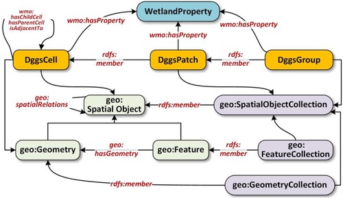
Table 4. CQs related to geospatial module.
To better describe the spatial objects and wetland regions, we introduced the term in landscape ecology, namely,
. This term refers to the spatial area composed of adjacent cells, which differ from the surrounding cells but has a certain internal homogeneity. In addition, some patches sharing the same attributes may belong to
, such as the following axioms:
(12)
(12)
(13)
(13)
4.5. WMO temporal context module
lists the CQs related to the temporal context. Temporal semantics play a big part in every aspect of creating a comprehensive knowledge representation for wetland monitoring. A specification of temporal semantics is required for wetland monitoring and subsequent applications. The OWL-Time (Hobbs and Pan Citation2006) is a robust specification ontology for temporal expressions that builds on OWL-Time ontology and extends it with wetland monitoring context. The goal is to provide an ontology of temporal semantics that is rich and sufficiently expressive for wetland monitoring tasks and subsequent knowledge-discovery applications.
Table 5. CQs related to temporal context module.
As shown in , to improve the accuracy of temporal expressions, we add the class . The temporal collection is crucial for modeling and reasoning about the time dimension of the wetland monitoring context. For example, it can help to model time sequences that may contain repeating time intervals or instants, which is useful for representing continuity monitoring tasks and wetland phenomena such as measuring the air quality at 8:00, 12:00, and 18:00. The WMO supports the collections
(
) and
(
), which are both subclasses of the more general class
.
(14)
(14)
(15)
(15)
(16)
(16)
Figure 8. Partial view of WMO temporal module.
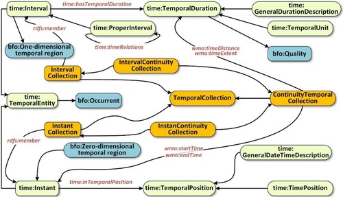
In addition, WMO introduces , a special temporal collection class. This class is useful for representing regular and recurrent monitoring tasks and wetland phenomena, such as measuring the water temperature every ten minutes.
represents a group of continuous temporal entities, with adjacent temporal entities separated by a constant distance. The properties
and
that link to the temporal instants represent their starting and ending instants. The
describe the extent of its members. Therefore, when its member is the interval, the property
must be specified. In contrast, if its members are
, there is no such property.
(17)
(17)
(18)
(18) Valid time and transaction time are two main types of temporal dimensions (Zhang et al. Citation2021). The transaction time is the time at which a sensor detects an event in a wetland, and the valid time is the true time of that event. We thus redefine the range of
as
and the range of
as
.
(19)
(19)
(20)
(20)
In more detail, the valid time is earlier than the transaction time of an event in the wetland monitoring domain. Although numerous monitoring systems emphasize real-time, the transaction time inevitably lags due to the sampling interval and network transmission. In addition, the transaction time must be an absolute time instant; the valid time, however, may be a time interval or a time instant.
(21)
(21)
(22)
(22)
4.6. Summary
This section presents a robust ontology christened WMO developed based on the domain of wetland monitoring but that primarily considers the wetland ecosystem, monitoring indicators, monitoring context, geospatial context, and temporal context. The ecosystem module can cite the objects that are monitored, the monitoring indicator module can cite the attributes of the monitoring object, the monitoring context module can explain how to monitor, the geospatial context module knows where the data are associated, and the temporal context module can tell when the data are produced. The WMO organically combines the five modules together to characterize wetland monitoring data.
5. Validation of the WMO
This section presents two real-world use cases to illustrate the use of the WMO for integrating and analysing multisource, heterogeneous, and cross-domain wetland monitoring data.
5.1. Use case 1: querying for monitoring platform using geospatial function
The first step in wetland analysis is to determine which monitoring stations have the data for the region of interest. The lack of semantic descriptions makes this step complex for both humans and machines. Database systems usually incorporate additional metadata about the monitoring station, but the lack of semantics cannot be alleviated by isolated metadata. For example, the metadata may incorporate the longitude and latitude information of the monitoring station, but the location and monitoring area are both hidden within it. In this use case, the goal is to query information on platforms and sensors monitoring the Zhanbeihu (a sub-lake of the Poyang Lake Wetland). To this end, two competency questions are answered in the use case.
As shown in , we translated the competency questions from natural language into SPARQL statements. For the first competency question (which monitoring platforms are deployed in Zhanbeihu and which sensors are equipped on these platforms?), we use , a GeoSPARQL function, to execute spatial inference and find all monitoring platforms that the Zhanbeihu contains. The
predicate is then used to query the sensors equipped on the monitoring platform. shows the assertions related to the query results in the ABox of the knowledge base. The Zhanbeihu has two monitoring platforms, one equipped with three sensors for air, weather, and water and the other equipped with a video sensor. The observation distance of the video sensor is limited, so the specific monitoring area of the video monitoring platform in Zhanbeihu must be known (the second competency question). First, we use the
function to derive the maximum capture area, following which we use the
function to find
, which intersects both Zhanbeihu and the maximum capture area. As shown in , the green grid is the video surveillance area of Zhanbeihu. The inference result can be saved explicitly as a
for direct use by subsequent tasks.
Figure 9. Query the information on platforms and sensors monitoring Zhanbeihu.
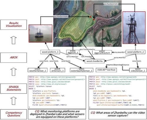
Figure 10. Query of multidomain, multisource, multimodal wetland monitoring data with the WMO.
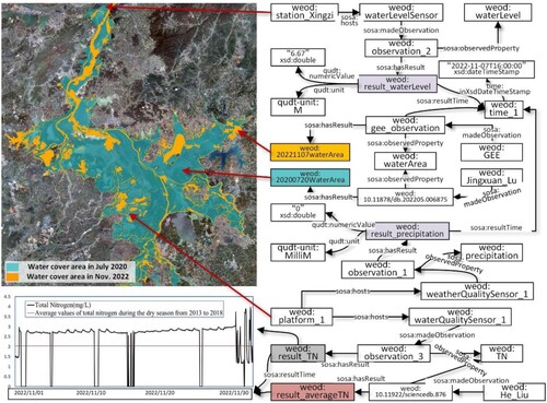
5.2. Use case 2: querying to merge heterogeneous monitoring data from different sensors
Wetlands are complex systems, and the interactions and feedback mechanisms within wetland ecosystems are also highly complex. Therefore, multiple monitoring data are needed to fully reflect the state and relationships of wetland ecosystems. Fortunately, a key function of ontology models is the semantic integration and consolidation of heterogeneous data from multiple sources. To verify that WMO has integration capabilities to facilitate advanced wetland analytical tasks, the goal in this use case is to use WMO to integrate multiple monitoring data to show the effect of pressure on the state of Poyang Lake in 2022.
The water level of Poyang Lake receded to 6.67 m at 4:00 on November 7, 2022, the lowest water level in history. Numerous publications show that water level is an important regulator of water quality in Poyang Lake. shows the correlated knowledge query of water level and water quality of Poyang Lake in 2022 during the dry period by the SPQRAL statement in the knowledge graph.
is a subclass of
and an observed attribute of the monitoring station (
) in Zhangbeihu. shows the precipitation of Poyang Lake on November 7, 2022. Due to the lack of precipitation, the monitoring station (
) observes that the water level of Poyang Lake has dropped to the lowest level in history, and the decrease in water level inevitably leads to the decrease of water area. We integrate the real-time land cover data from Google (Brown et al. Citation2022) and from a public dataset (Lu Citation2022). We extract the water surface area for the same period from the Google real-time land cover dataset. The public dataset contains the water area data of Poyang Lake for July 20, 2020 when the water level of Poyang Lake was the highest in history. By comparison, the water area of Poyang Lake is greatly reduced. Furthermore, we query the change of one water-quality indicator (total nitrogen) of the Zhangbeihu. shows the monitored data every hour in November 2022, which were compared with the historical average data from the dataset (Liu et al. Citation2019) from the dry period 2013–2018. The result shows that the total nitrogen content increased significantly during the time of an extremely low water level in Poyang Lake wetland. The analysis of these columns shows that the water quality of the Poyang Lake wetland changed due to climate change in 2022.
The WMO facilitates finding wetland information with respect to manually cross-referencing multiple relational databases. In this use case, we verified the advantage of improving data interoperability by linking:
Multiple sources of wetland monitoring data, including from multiple monitoring stations and people (or organizations).
Multidomain monitoring data, including meteorology, water quality, and land cover.
Heterogeneous monitoring data, including numerical, time-series, and remote sensing.
6. Discussion
With the aggravation of climate change, the impact on wetland ecosystems is increasing. To better understand how climate change affects wetlands, monitoring wetland data is crucial. This study shows that one of the main advantages of WMO is that it allows us to represent and merge knowledge involving wetland data analytics. The saying ‘a little semantics goes a long way’ (Ma Citation2022) is also true for WMO in wetland monitoring. This semantic approach allows us to annotate wetland monitoring data flowing from multiple sources, including sensors and organizations. The wetland monitoring data are integrated following the WMO structure and stored in a knowledge graph. In a wetland knowledge graph, wetland researchers and computer agents can then easily link new monitoring data to deduce new knowledge and traverse links to discover how parts of the wetland ecosystem relate to each other. Overall, the WMO is efficient and helps create the knowledge graph for wetland monitoring.
summarizes the comparison between WMO and other relevant ontologies. Most domain ontologies can only represent concepts and relationships in specific domains, but not the common properties of concept sets in multiple domains and the universal relationships among concepts, which fragment the universal connection of knowledge among domains and are not conducive to the reuse and integration of domain knowledge. The DPSIR framework divides wetland monitoring data from different sources and discipline types into five aspects: driver, pressure, state, impact, and response and achieves semantic integration by improving the consistency and comprehensibility of monitoring data, thus facilitating the implementation of wetland management and decision-making. Conversely, the DGGS in conjunction with ontology offers a new solution for various monitoring data integration in the wetland knowledge graph. The WMO uses DGGS to unify all wetland monitoring data in one geospatial reference. Thus, the spatial information is stored in a ‘congruent geography’ instead of in the sliced theme layers. A DGGS-based geospatial semantics module could form the foundation of a computationally efficient, naturally multiscale and multistakeholder wetland digital twin, allowing for user-defined representations of diverse forms of geographical knowledge of wetlands (Hojati et al. Citation2022).
Table 6. Comparison between WMO and other ontologies.
A useful ontology must simultaneously strive for usable and reusable (Morbach, Wiesner, and Marquardt Citation2009; Cuenca, Larrinaga, and Curry Citation2020). WMO achieves alignment with upper-level ontology, reusing existing authoritative ontologies. Compared with the previous studies (Xing, Han, and Tao Citation2009; Mughal et al. Citation2021), aligning the upper-level ontology can make the WMO more applicable to different wetland monitoring domains and application scenarios, improving the reusability and scalability of WMO. Reusing existing ontologies (e.g. ENVO, SOSA, GeoSPARQL, owl-time) can exploit their already-validated and tested concepts and relationships, thereby avoiding the duplicate modeling of the same concepts and relationships. Another benefit of reusing existing ontologies is that it is easier to combine data from different sources and applications by providing a common vocabulary and structure for data.
In terms of practical implications, although the two use cases given in this study represent information about wetland water-environment monitoring, the WMO can also be used in other wetland contexts. For example, ornithologists can use WMO to correlate the environmental data related to migratory bird tracks and habitats to assess locations where wetlands would be suitable for bird activities. Disaster scholars can assess the losses caused by disasters and predict the occurrence of the next disaster by correlating meteorological, hydrological, geological, and other multisource data. Conversely, the digital twin has recently been widely mentioned in the field of wetland management, such as the digital twinning basin (Chen, Fang, and Xiao Citation2023; Lu, Fang, and Xiao Citation2023). However, developing such a highly digitized and intelligent digital twin, requires efficient monitoring-data integration and knowledge management. The WMO can provide an intermediary for mapping real wetland to virtual space by correlating and organizing real-time monitoring data of wetland, further supporting the modeling and analysis in twin space.
Although such an ontology is promising, the WMO remains in its initial stage and thus has some limitations. The current version of the WMO is weak in semantic expressions of various environmental events and ecological processes in wetlands. Although the introduction of the DPSIR can sort out the relationship between various monitoring indicators, the causal relationship between events has not been modeled in the current version of the WMO. The requisite follow-up work is thus to scale WMO use cases to more complex scenarios, such as wetland biological habitat protection, flood monitoring, and pollution prevention and control. In future work, we will add extensions to the WMO based on new data modeling and practical use cases. In addition, we will annotate the scope of classes and attributes in more detail and provide WMO-specification documents to ensure long-term sustainability.
7. Conclusion
This study proposes a usable and reusable wetland monitoring ontology consisting of five modules: wetland ecosystem, monitoring indicators, monitoring context, geospatial context, and temporal context. The WMO provides a semantic framework for the integration of wetland monitoring data and enriched analysis, which can lead to the unified management and querying of wetland monitoring data and improve data reusability and interoperability. Furthermore, using the WMO to build a wetland knowledge graph improves the resulting wetland monitoring system and supports intelligent decision-making and intelligent services. In addition, the development and improvement of the ontology is a continuous process, so the WMO ontology should be revised and improved in the process of large-scale practical application in the future.
Acknowledgments
Thanks to the Jiangxi Poyang Lake Wetland Ecosystem Monitoring and Early Warning Platform Construction Project hosted by Jiangxi Nature Reserve Construction Center for supporting this study. We appreciate the detailed suggestions and comments from the editor and the anonymous reviewers.
Data availability statement
Data available on request from the authors.
Disclosure statement
No potential conflict of interest was reported by the author(s).
Additional information
Funding
References
- Arvor, Damien, Laurent Durieux, Samuel Andrés, and Marie-Angélique Laporte. 2013. “Advances in Geographic Object-Based Image Analysis with Ontologies: A Review of Main Contributions and Limitations from a Remote Sensing Perspective.” ISPRS Journal of Photogrammetry and Remote Sensing 82: 125–137. doi:10.1016/j.isprsjprs.2013.05.003.
- Booshehri, Meisam, Lukas Emele, Simon Flügel, Hannah Förster, Johannes Frey, Ulrich Frey, Martin Glauer, et al. 2021. “Introducing the Open Energy Ontology: Enhancing Data Interpretation and Interfacing in Energy Systems Analysis.” Energy and AI 5: 100074. doi:10.1016/j.egyai.2021.100074.
- Borgo, Stefano, Roberta Ferrario, Aldo Gangemi, Nicola Guarino, Claudio Masolo, Daniele Porello, Emilio M. Sanfilippo, and Laure Vieu. 2022. “DOLCE: A Descriptive Ontology for Linguistic and Cognitive engineering1.” Applied Ontology 17: 45–69. doi:10.3233/AO-210259.
- Bouyerbou, Hafidha, Kamal Bechkoum, and Richard Lepage. 2019. “Geographic Ontology for Major Disasters: Methodology and Implementation.” International Journal of Disaster Risk Reduction 34: 232–242. doi:10.1016/j.ijdrr.2018.11.021.
- Brown, Christopher F., Steven P. Brumby, Brookie Guzder-Williams, Tanya Birch, Samantha Brooks Hyde, Joseph Mazzariello, Wanda Czerwinski, et al. 2022. “Dynamic World, Near Real-Time Global 10 m Land use Land Cover Mapping.” Scientific Data 9 (1): 251. doi:10.1038/s41597-022-01307-4.
- Buttigieg, Pier Luigi, Norman Morrison, Barry Smith, Christopher J. Mungall, Suzanna E. Lewis, and Envo Consortium the. 2013. “The Environment Ontology: Contextualising Biological and Biomedical Entities.” Journal of Biomedical Semantics 4 (1): 43. doi:10.1186/2041-1480-4-43.
- Chen, Hao, Chaoyang Fang, and Xin Xiao. 2023. “Visualization of Environmental Sensing Data in the Lake-Oriented Digital Twin World: Poyang Lake as an Example.” Remote Sensing 15 (5), doi:10.3390/rs15051193.
- Compton, Michael, Payam Barnaghi, Luis Bermudez, Raúl García-Castro, Oscar Corcho, Simon Cox, John Graybeal, et al. 2012. “The SSN Ontology of the W3C Semantic Sensor Network Incubator Group.” Journal of Web Semantics 17: 25–32. doi:10.1016/j.websem.2012.05.003.
- Cuenca, Javier, Felix Larrinaga, and Edward Curry. 2020. “DABGEO: A Reusable and Usable Global Energy Ontology for the Energy Domain.” Journal of Web Semantics 61-62: 100550. doi:10.1016/j.websem.2020.100550.
- Davidson, N. C., and C. M. Finlayson. 2007. “Earth Observation for Wetland Inventory, Assessment and Monitoring.” Aquatic Conservation: Marine and Freshwater Ecosystems 17 (3): 219–228. doi:10.1002/aqc.846.
- Davis, Jenny, and Margaret Brock. 2008. “Detecting Unacceptable Change in the Ecological Character of Ramsar Wetlands.” Ecological Management & Restoration 9 (1): 26–32. doi:10.1111/j.1442-8903.2008.00384.x.
- Ding, Yulin, Qing Zhu, and Hui Lin. 2014. “An Integrated Virtual Geographic Environmental Simulation Framework: A Case Study of Flood Disaster Simulation.” Geo-spatial Information Science 17 (4): 190–200. doi:10.1080/10095020.2014.988199.
- Dubey, Shripriya, Archana Patel, and Sarika Jain. 2021. “Chapter 3 - Conversion Between Semantic Data Models: The Story so far, and the Road Ahead.” In Web Semantics, edited by Sarika Jain, Vishal Jain, and Valentina Emilia Balas, 23–30. Academic Press.
- Durbha, S. S., R. L. King, V. P. Shah, and N. H. Younan. 2009. “A Framework for Semantic Reconciliation of Disparate Earth Observation Thematic Data.” Computers & Geosciences 35 (4): 761–773. doi:10.1016/j.cageo.2008.04.011.
- Fernández-López, Mariano, Asunción Gómez-Pérez, and Natalia Juristo. 1997. “Methontology: From Ontological Art Towards Ontological Engineering.” Paper Presented at the AAAI Conference on Artificial Intelligence.
- Ficken, Cari D., Stephanie J. Connor, Rebecca Rooney, and Danielle Cobbaert. 2022. “Drivers, Pressures, and State Responses to Inform Long-Term oil Sands Wetland Monitoring Program Objectives.” Wetlands Ecology and Management 30 (1): 47–66. doi:10.1007/s11273-021-09828-2.
- Garcia, Luan Fonseca, Mara Abel, Michel Perrin, and Renata dos Santos Alvarenga. 2020. “The GeoCore Ontology: A Core Ontology for General use in Geology.” Computers & Geosciences 135: 104387. doi:10.1016/j.cageo.2019.104387.
- Goodchild, Michael F. 2007. “Citizens as Sensors: The World of Volunteered Geography.” GeoJournal 69 (4): 211–221. doi:10.1007/s10708-007-9111-y.
- Goodchild, Michael F. 2018. “Reimagining the History of GIS.” Annals of GIS 24 (1): 1–8. doi:10.1080/19475683.2018.1424737.
- Gruber, Thomas R. 1993. “A Translation Approach to Portable Ontology Specifications.” Knowledge Acquisition 5 (2): 199–220. doi:10.1006/knac.1993.1008.
- Guarino, Nicola, Daniel Oberle, and Steffen Staab. 2009. “What Is an Ontology?” In Handbook on Ontologies, edited by Steffen Staab, and Rudi Studer, 1–17. Berlin, Heidelberg: Springer Berlin Heidelberg.
- Hobbs, Jerry R, and Feng Pan. 2006. “Time Ontology in OWL.” W3C Working Draft 27 (133): 3–36. https://www.w3.org/TR/owl-time/
- Hojati, Majid, Colin Robertson, Steven Roberts, and Chiranjib Chaudhuri. 2022. “GIScience Research Challenges for Realizing Discrete Global Grid Systems as a Digital Earth.” Big Earth Data 6 (3): 358–379. doi:10.1080/20964471.2021.2012912.
- Janowicz, Krzysztof, Armin Haller, Simon J. D. Cox, Danh Le Phuoc, and Maxime Lefrançois. 2019. “SOSA: A Lightweight Ontology for Sensors, Observations, Samples, and Actuators.” Journal of Web Semantics 56: 1–10. doi:10.1016/j.websem.2018.06.003.
- Kovács, Gyula Mate, Stéphanie Horion, and Rasmus Fensholt. 2022. “Characterizing Ecosystem Change in Wetlands Using Dense Earth Observation Time Series.” Remote Sensing of Environment 281: 113267. doi:10.1016/j.rse.2022.113267.
- Kuster, Corentin, Jean-Laurent Hippolyte, and Yacine Rezgui. 2020. “The UDSA Ontology: An Ontology to Support Real Time Urban Sustainability Assessment.” Advances in Engineering Software 140: 102731. doi:10.1016/j.advengsoft.2019.102731.
- Li, Mingke, and Emmanuel Stefanakis. 2020. “Geospatial Operations of Discrete Global Grid Systems—a Comparison with Traditional GIS.” Journal of Geovisualization and Spatial Analysis 4 (2): 26. doi:10.1007/s41651-020-00066-3.
- Liu, He, Qi Zhang, Yuanyuan Niu, and Ligang Xu. 2019. “A Dataset of Water Environment Survey in the Poyang Lake from 2013 to 2018.” In Science Data Bank. https://doi.org/10.11922/sciencedb.876
- Lu, Jingxuan. 2022. “Spatial Distribution Data set of Maximum Watershed Area of Flood in Poyang Lake on July 20, 2020.” In Science Data Bank. https://doi.org/10.11878/db.202205.006875
- Lu, Sheng, Chaoyang Fang, and Xin Xiao. 2023. “Virtual Scene Construction of Wetlands: A Case Study of Poyang Lake, China.” ISPRS International Journal of Geo-Information 12 (2), doi:10.3390/ijgi12020049.
- Ma, Xiaogang. 2022. “Knowledge Graph Construction and Application in Geosciences: A Review.” Computers & Geosciences 161: 105082. doi:10.1016/j.cageo.2022.105082.
- Malekmohammadi, B., and F. Jahanishakib. 2017. “Vulnerability Assessment of Wetland Landscape Ecosystem Services Using Driver-Pressure-State-Impact-Response (DPSIR) Model.” Ecological Indicators 82: 293–303. doi:10.1016/j.ecolind.2017.06.060.
- Masmoudi, Maroua, Mohamed Hedi Karray, Sana Ben Abdallah Ben Lamine, Hajer Baazaoui Zghal, and Bernard Archimede. 2020. “MEMON: Modular Environmental Monitoring Ontology to Link Heterogeneous Earth Observed Data.” Environmental Modelling & Software 124: 104581. doi:10.1016/j.envsoft.2019.104581.
- Mekonnen, Daniel, David Price, Jack Hodges, James E. Masters, Simon J D Cox, and Steve Ray. 2022. “Quantities, Units, Dimensions and Types (QUDT) Schema - Version 2.1.21.” Accessed 2022-11-29. https://qudt.org/.
- Mishra, Sanju, and Sarika Jain. 2020. “Ontologies as a Semantic Model in IoT.” International Journal of Computers and Applications 42 (3): 233–243. doi:10.1080/1206212X.2018.1504461.
- Morbach, Jan, Andreas Wiesner, and Wolfgang Marquardt. 2009. “OntoCAPE-A (re)Usable Ontology for Computer-Aided Process Engineering.” Computers & Chemical Engineering 33 (10): 1546–1556. doi:10.1016/j.compchemeng.2009.01.019.
- Mughal, M. H., Z. A. Shaikh, A. I. Wagan, Z. H. Khand, and S. Hassan. 2021. “ORFFM: An Ontology-Based Semantic Model of River Flow and Flood Mitigation.” IEEE Access 9: 44003–44031. doi:10.1109/ACCESS.2021.3066255.
- Noy, N., and Deborah McGuinness. 2001. “Ontology Development 101: A Guide to Creating Your First Ontology.” Knowledge Systems Laboratory 32.
- Oesterwind, Daniel, Andrea Rau, and Anastasija Zaiko. 2016. “Drivers and Pressures – Untangling the Terms Commonly Used in Marine Science and Policy.” Journal of Environmental Management 181: 8–15. doi:10.1016/j.jenvman.2016.05.058.
- Otte, J. Neil, John Beverley, and Alan Ruttenberg. 2022. “BFO: Basic Formal Ontology1.” Applied Ontology 17: 17–43. doi:10.3233/AO-220262.
- Pease, Adam, Ian Niles, and John Li. 2002. “The Suggested Upper Merged Ontology: A Large Ontology for the Semantic Web and its Applic Ations.” Paper Presented at the AAAI Technical Report WS-02-11.
- Peroni, Silvio. 2017. “A Simplified Agile Methodology for Ontology Development.” Paper Presented at the OWL: Experiences and Directions – Reasoner Evaluation, Cham, 2017.
- Perry, M., and J. Herring. 2023. “OGC GeoSPARQL - A Geographic Query Language for RDF Data.” Accessed 2023-03-10.
- Raskin, Robert G., and Michael J. Pan. 2005. “Knowledge Representation in the Semantic web for Earth and Environmental Terminology (SWEET).” Computers & Geosciences 31 (9): 1119–1125. doi:10.1016/j.cageo.2004.12.004.
- Rawson, Andrew, Zoheir Sabeur, and Mario Brito. 2022. “Intelligent Geospatial Maritime Risk Analytics Using the Discrete Global Grid System.” Big Earth Data 6 (3): 294–322. doi:10.1080/20964471.2021.1965370.
- Rožanec, Jože M., Fortuna Blaž, and Dunja Mladenić. 2022. “Knowledge Graph-Based Rich and Confidentiality Preserving Explainable Artificial Intelligence (XAI).” Information Fusion 81: 91–102. doi:10.1016/j.inffus.2021.11.015.
- Rubí, Jesús Noel Suárez, and Paulo Roberto de Lira Gondim. 2021. “IoT-Based Platform for Environment Data Sharing in Smart Cities.” International Journal of Communication Systems 34 (2): e4515. doi:10.1002/dac.4515.
- Scheuer, Sebastian, Dagmar Haase, and Volker Meyer. 2013. “Towards a Flood Risk Assessment Ontology – Knowledge Integration Into a Multi-Criteria Risk Assessment Approach.” Computers, Environment and Urban Systems 37: 82–94. doi:10.1016/j.compenvurbsys.2012.07.007.
- Shimizu, Cogan, Karl Hammar, and Pascal Hitzler. 2022. “Modular Ontology Modeling.” Semantic Web Preprint:1-31, doi:10.3233/SW-222886.
- Staab, S., R. Studer, H. P. Schnurr, and Y. Sure. 2001. “Knowledge Processes and Ontologies.” IEEE Intelligent Systems 16 (1): 26–34. doi:10.1109/5254.912382.
- Studer, Rudi, V. Richard Benjamins, and Dieter Fensel. 1998. “Knowledge Engineering: Principles and Methods.” Data & Knowledge Engineering 25 (1): 161–197. doi:10.1016/S0169-023X(97)00056-6.
- Suárez-Figueroa, Mari Carmen, Asunción Gómez-Pérez, and Mariano Fernández-López. 2015. “The NeOn Methodology framework: A scenario-based methodology for ontology development.” Applied Ontology 10: 107–145. doi:10.3233/AO-150145.
- Sun, Baoyu, Ming Jiang, Guangxuan Han, Liwen Zhang, Jian Zhou, Chenyu Bian, Ying Du, Liming Yan, and Jianyang Xia. 2022. “Experimental Warming Reduces Ecosystem Resistance and Resilience to Severe Flooding in a Wetland.” Science Advances 8 (4): eabl9526. doi:10.1126/sciadv.abl9526.
- Sun, Kai, Yunqiang Zhu, Peng Pan, Zhiwei Hou, Dongxu Wang, Weirong Li, and Jia Song. 2019. “Geospatial Data Ontology: The Semantic Foundation of Geospatial Data Integration and Sharing.” Big Earth Data 3 (3): 269–296. doi:10.1080/20964471.2019.1661662.
- Vilches-Blázquez, Luis M., Boris Villazón-Terrazas, Oscar Corcho, and Asunción Gómez-Pérez. 2014. “Integrating geographical information in the Linked Digital Earth.” International Journal of Digital Earth 7 (7): 554–575. doi:10.1080/17538947.2013.783127.
- Wang, Xiaolei, Haitao Wei, Nengcheng Chen, Xiaohui He, and Zhihui Tian. 2020. “An Observational Process Ontology-Based Modeling Approach for Water Quality Monitoring.” Water 12 (3), doi:10.3390/w13010012.
- Wang, Wenyu, Peng Yang, Jun Xia, Shengqing Zhang, and Sheng Hu. 2023. “Changes in the Water Environment and its Major Driving Factors in Poyang Lake from 2016 to 2019, China.” Environmental Science and Pollution Research 30 (2): 3182–3196. doi:10.1007/s11356-022-22136-3.
- Wu, Jiantao, Fabrizio Orlandi, Declan O’Sullivan, and Soumyabrata Dev. 2022. “Link Climate: An Interoperable Knowledge Graph Platform for Climate Data.” Computers & Geosciences 105215, doi:10.1016/j.cageo.2022.105215.
- Xiao, Xin, Chaoyang Fang, Hui Lin, and Jingfu Chen. 2022. “A Framework for Quantitative Analysis and Differentiated Marketing of Tourism Destination Image Based on Visual Content of Photos.” Tourism Management 93: 104585. doi:10.1016/j.tourman.2022.104585.
- Xing, Jun, Min Han, and Xueheng Tao. 2009. “A Wetland Protection Domain Ontology Construction for Knowledge Management and Information Sharing.” Human and Ecological Risk Assessment: An International Journal 15 (2): 298–315. doi:10.1080/10807030902761213.
- Zárate, Marcos, Germán Braun, Pablo Fillottrani, Claudio Delrieux, and Mirtha Lewis. 2020. “BiGe-Onto: An Ontology-Based System for Managing Biodiversity and Biogeography data1.” Applied Ontology 15: 411–437. doi:10.3233/AO-200228.
- Zhang, Fu, Zhiyin Li, Dunhong Peng, and Jingwei Cheng. 2021. “RDF for Temporal Data Management – a Survey.” Earth Science Informatics 14 (2): 563–599. doi:10.1007/s12145-021-00574-w.