
 ?Mathematical formulae have been encoded as MathML and are displayed in this HTML version using MathJax in order to improve their display. Uncheck the box to turn MathJax off. This feature requires Javascript. Click on a formula to zoom.
ABSTRACT
Property disputes are frequent occurrences in rapidly urbanizing regions. Among the legal issues concerning building property rights, solar rights disputes are prevalent because text clauses on solar rights rely on diverse measurements or calculations. Moreover, previous studies on measuring solar rights addressed only the sunlight duration and neglected the daylight factor (daylighting coefficient), which is an integral component of solar rights. Therefore, this study proposes a 3D spatiotemporal model for effectively measuring solar rights by taking both the sunlight duration and the daylight factor into consideration. This model would be technologically valuable in avoiding or settling legal disputes. Taking the specifications of the solar rights of building property in China as a case study, the proposed spatiotemporal model clarifies the complete solar rights of residential units and is implemented by integrating a geometric model from CityGML with a property model, namely, the Land Administration Domain Model (LADM). Three real typical cases are adopted to show the applicability and benefit of the 3D spatiotemporal model in resolving legal property disputes.
1. Introduction
Solar rights are one of the fundamental rights of a property owner, playing a vital role in human health, well-being, and sustainability (Turan et al. Citation2020; Zielinska-Dabkowska and Xavia Citation2019). The ability to utilize the sun’s light, warmth, or energy has significant economic consequences, making the calculation of solar rights a critical factor in decision-making in property management and determining lawsuits concerning solar rights among neighbors (Bronin Citation2015). However, no reliable and unified model for calculating solar rights has been developed, resulting in a growing number of legal disputes in countries with rapidly urbanizing populations, such as China (Lee and Lee Citation2020).
Although the legal description of solar rights suggests principled regulations, it suffers from some semantic ambiguity. In practice, the lack of clear guidelines for calculating solar rights has resulted in approximately 3,000 legal disputes over solar rights in China from 2018–2020 (Wolters Kluwer Legal Information Database Citation2011). The primary challenge in accurately calculating solar rights lies in identifying the spatial and temporal attributes of residential units, for which a 3D spatiotemporal data model constitutes a technically reliable means for successful determination of 3D building property rights and can provide decisive technological help in resolving legal conflicts (Aien et al. Citation2013a; Drobež et al. Citation2017; Shojaei et al. Citation2015).
While many existing studies on solar rights focus on legal issues and the need for future amendments to related laws and regulations (Fernández, Gentili, and Campo Citation2022; Hraška Citation2019; Jacobson, Carlson, and Lindahl Citation2021; Yang Citation2013), only a limited number of studies have examined spatiotemporal models for calculating solar rights (Li et al. Citation2019; Seong et al. Citation2006). The two critical indices for measuring solar rights are sunlight duration and daylight factor (Bronin Citation2009). Although existing studies have primarily focused on calculating sunlight duration to measure solar rights by considering time and the relative positions of buildings, they have overlooked the daylight factor, which is an essential component of measuring solar rights (Arecchi, Messadi, and Koshel Citation2007).
A 3D spatiotemporal model that incorporates both legal and physical information is necessary for the effective management of solar rights. The physical information includes spatial and semantic elements of buildings, while the legal information encompasses ownership attributes and their corresponding spatial extents. The Land Administration Domain Model (LADM) (ISO19152 Citation2012) has received significant attention as a conceptual model for managing land-related rights. LADM consists of three primary data packages: the Parties Package, the Administration Package, and the Spatial Unit Package (Lemmen, Van Oosterom, and Bennett Citation2015; Van Oosterom and Lemmen Citation2015). LADM provides a legal framework that is beneficial for solar rights management. CityGML (OGC Citation2012) is a significant physical data model for representing building property rights, which enables the description of 3D geometric, topological, semantic, and appearance-based information of related physical entities (Góźdź et al. Citation2014; Li et al. Citation2016; Rönsdorf, Wilson, and Stoter Citation2014). CityGML also provides a unified mechanism –Application Domain Extension (ADE), to extend and enhance the features in specific application domains (Agugiaro et al. Citation2018; Blut and Blankenbach Citation2021; Kolbe, Gröger, and Plümer Citation2005), by which solar rights can be implemented in the 3D model within CityGML. The integration of legal and physical objects in virtual 3D cities and cadastral models has been investigated in various studies (Aien et al. Citation2013b; Atazadeh et al. Citation2021; Rajabifard, Atazadeh, and Kalantari Citation2018).
Therefore, the objective of this study is to propose a reliable and unified 3D spatiotemporal model implemented through CityGML and LADM to represent solar rights, encompassing both sunlight duration and daylight factor calculations. This proposed model will provide a complete technological solution for accurately and efficiently calculating solar rights, addressing the current challenges in identifying the spatial and temporal attributes of residential units. The model will also consider the daylight factor, an essential component of measuring solar rights that has been overlooked in previous studies. In addition to improvement on the 3D model for solar rights of property, this study also presents exemplars of reliable and effective solutions to legal conflicts over solar rights based on three case studies adopted from real-world scenarios.
The remainder of this paper is organized as follows: Section 2 briefly describes the relevant background of solar rights, especially the data requirements and the calculation method for the indices of solar rights. Section 3 presents the proposed 3D spatiotemporal model for calculating solar rights, including both sunlight duration and daylight factor calculations. Section 4 presents three case studies based on real-world scenarios to demonstrate the model’s ability to provide a reliable and effective solution to legal conflicts over solar rights. The last section presents the concluding remarks and a brief discussion of future works.
2. Legal context and calculation of solar rights
2.1. Basic concepts
Clear definitions of solar rights are crucial for calculation, as they provide the necessary information about properties with solar access rights. However, the definitions of solar rights can vary among different jurisdictions. In China, for instance, solar rights refer to the right of property or usufructuary owners to require their neighbors to limit the distances and/or heights of their buildings to obtain sunlight (People’s Republic of China Citation2007). The solar rights in China encompasses two types of rights: neighboring daylight rights and daylighting easements (Sun Citation2006a).
Neighboring daylight rights require adjacent property owners to handle their lighting relationship in a fair and reasonable manner that is conducive to productive and convenient living, and mutual support (Huang Citation2011). This means that property owners are required to respect each other’s access to sunlight and take measures to ensure that their buildings do not interfere with their neighbors’ access to sunlight.
Daylighting easements are spatial easements that protect property owners’ lighting requirements and restrict neighboring properties from interfering with their lighting (Ma and Chen Citation2014; Sun Citation2006b). These easements are designed to ensure that neighboring structures or buildings do not obstruct sunlight.
2.2. Data requirements and calculation methods for neighboring daylight rights
Sunlight duration and daylight factor are two important indices for neighboring daylight rights (). Sunlight duration refers to the amount of time that a location receives direct sunlight over a specified period, such as a day or a year. The spatial relation between buildings is also taken into account when calculating sunlight duration because nearby buildings can block sunlight from reaching a property. In contrast, daylight factor measures the amount of natural light that enters a building and considers both the spatial relationship between buildings and the internal structure of the building. It is a ratio that compares the amount of natural light available inside a building to the amount of natural light available outside under overcast skies (Arecchi, Messadi, and Koshel Citation2007). While sunlight duration is a climatological indicator calculated for a given location on Earth (Ahmad et al. Citation2017), the daylight factor provides insight into the actual amount of natural light available inside a building, which is important when determining solar rights.
Table 1. Comparison of sunlight duration and daylight factor.
The sunlight duration is specified in the Code of Urban Residential Area Planning and Design (People’s Republic of China Citation2018). Within the effective sunshine time range of the specified sunshine standard day, an external window of a building obtains full window sunshine depending on factors such as the building climatic zones (Yang, Lam, and Tsang Citation2008) (a) where the building is located, the size of the city, and the nature of the building’s use (). The minimum daylight factor corresponding to each of the daylight climate zones (Bai and Wang Citation2019; Hong, Zhang, and Du Citation2021) (b) is shown in of the Standard for the Daylighting Design of Buildings (People’s Republic of China Citation2013), which contains the requirements for daylighting design.
Figure 1. The building climate zones of sunlight duration and the daylight climate zones of daylight factor.
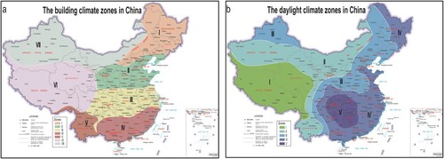
Table 2. Sunshine standards for residential buildings.
Table 3. Daylight climate zones and daylight factor.
2.2.1. Calculation of the sunlight duration
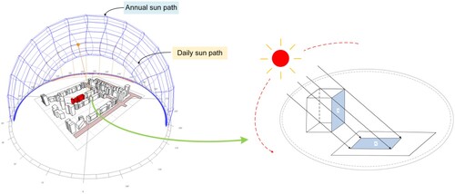
Sunlight duration is a crucial metric for understanding the total amount of continuous sunshine time available in a specific area (Bakirci Citation2009). To calculate sunlight duration, various influential factors need to be considered, such as the effective sunlight zone, sun altitude angle, sunshine base year, sunlight reference day, period of effective sunlight, building climate zones, city type, geographic dimension, and reference position for sunlight assessment (see ). The effective sunlight zone is typically between 8:00 - 16:00 or 9:00 - 15:00, and it represents the period during which the sun’s rays are strong enough to provide direct illumination. The quantitative method for calculating sunlight duration involves assessing building occlusion based on the sun’s trajectory, which is determined using the annual sun path and daily sun path on a specific date within the simulated sunlight base year.
To determine sunlight duration at a specific position in space, the first step is to assess whether other buildings or walls obstruct the position. If the position is obstructed, the range between the occlusion surface and the shadow surface is referred to as the shadow domain. The assessment of occlusion involves determining whether a position is within the shadow area of surrounding buildings. If a position is in the shadow of a building, it is assumed to be blocked and does not receive sunlight at that time. A pair of corresponding positions, measurement position A and projection position A’, is used to determine whether a position is in a shadow area, as depicted in . The calculation of sunlight duration necessitates careful consideration of numerous factors, highlighting the importance of employing reliable data sources and software tools. Once the Tianzheng Sunlight software (Citation2003) is set with the relevant calculation parameters, the result is converted into time. By providing modeling and analysis functionalities, the software proves to be a valuable resource for accurately calculating sunlight duration and conducting comprehensive sunshine analysis. Users can effectively evaluate the availability of sunlight across diverse building climate zones in China. Consequently, the Tianzheng Sunlight software assumes an indispensable and crucial role for professionals engaged in architectural design, urban planning, and real estate development, empowering them with the means to make informed decisions.
Figure 2. Diagram of the method for calculating the duration of sunlight based on a 3D scene.
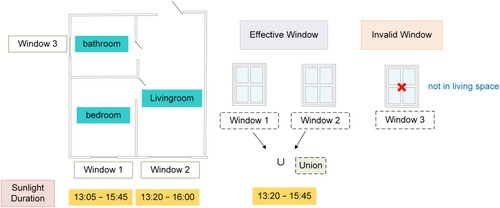
Calculating the sunlight duration per residential unit window is insufficient for determining the sunlight duration of a residential unit. According to the Code of Urban Residential Area Planning and Design (People’s Republic of China Citation2018), a residential unit must have at least one living space (bedroom and living room) that receives sunlight in winter, and the sunlight duration should meet the requirements in . Therefore, the sunlight duration of a residential unit is based on the living space’s sunlight duration. Although existing standards specify the sunlight duration requirements in residential units, they do not provide a method for calculating the sunlight duration when it varies across the unit’s internal windows. Consequently, we have developed a calculation method for the sunlight duration of each window in a complete set of residential units (see ). Windows that are not in the living space are disregarded in the calculation (Window 3). Thus, the sunlight duration of a residential unit is the union of Windows 1 and 2 (13:05 − 15:45∪13:20 − 16:00), and the final outcome represents the residential unit’s sunlight duration (13:20 − 15:45).
Figure 3. Calculation method of the sunlight duration for residential units.
2.2.2. Calculation of the daylight factor
The daylight factor is a fundamental metric used to assess the indoor daylighting of buildings. It is defined as the ratio of the illuminance at a given position inside a building to the simultaneous illuminance on a horizontal plane outside the building, under an unobstructed hemisphere of the overcast sky (Arecchi, Messadi, and Koshel Citation2007; Iversen et al. Citation2013). Mathematically, it is expressed as.
(1)
(1) where
is the illuminance due to daylight at a position on a given plane indoors, and
is the outdoor illuminance at the same time and location.
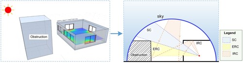
The calculation of the daylight factor depends on the spatial relationship between the building and its surroundings, as well as the internal structure of the building. A higher daylight factor value in a room indicates a better indoor daylighting effect. The UK Building Research Establishment (BRE) uses the split-flux method () to calculate the daylight factor (Yun Citation2010). The split-flux method is also used by some daylight factor calculation software, such as Dynamic Daylighting software utilized in this study. This method considers the daylight factor at a specific position in a room as the sum of three components: the Sky Component (SC), the External Reflected Component (ERC), and the Internal Reflected Component (IRC) (Sudan, Tiwari, and Al-Helal Citation2015; Tregenza Citation1989). The SC represents the light directly emanating from the patch of visible sky at that position; the ERC represents the light that reaches the position after reflecting off opposing exterior surfaces; and the IRC represents the light that enters through a window but reaches the position only after reflecting off internal surfaces. The calculation formula of the daylight factor is as follows:
(2)
(2) It is worth noting that the Dynamic Daylighting software (Citation2021), employed in this study, utilizes the split-flux method to calculate the daylight factor. This software offers dynamic simulations of daylight distribution within a given space, accounting for various factors including room dimensions, aperture configurations, shading devices, and external obstructions. By considering these parameters, the software enables the assessment of the daylight factor over time, facilitating an in-depth understanding of temporal variations and the spatial distribution of daylight within the analyzed space.
Figure 4. Schematic diagram of the split-flux method.
2.3. Data requirements for daylighting easements
According to the stipulations on easements in the Civil Code of the People’s Republic of China (People’s Republic of China Citation2021), the easement holder has the right to use other people's real estate in accordance with the contract to improve the benefits of his own real estate. The data requirements of the daylighting easement are based on the content of the contract, generally including the following:
The address of the servient estate (the property subject to the easement) and dominant estate (the property benefiting from the easement).
The purpose and duration of the easement, including the specific period during which the easement will be in effect and the conditions under which it may be terminated.
The procedures and methods for resolving any disputes that may arise from the daylighting easement contract.
Any other terms or conditions agreed upon by the parties involved in the contract.
3. Spatiotemporal expression model of solar rights
The proposed spatiotemporal framework of solar rights is constructed by integrating the legal concept of the LADM into the CityGML. This integration enables the comprehensive expression of three-dimensional (3D) solar rights within the CityGML framework. The framework encompasses both legal objects, as discussed in Section 3.2, and physical objects, as elaborated in Section 3.3. The relationships between these objects are further explored in Section 3.4, emphasizing their interconnectedness and interdependencies within the overall model. To achieve this integration, the ADE mechanism provided by CityGML is utilized. By leveraging the ADE mechanism, the attributes of the CityGML data model can be tailored and expanded to accommodate the specific requirements associated with solar rights. Section 3.5 provides a comprehensive discussion of the attributes that require customization and further elaboration during the extension process. One of the critical points in this study is to establish a robust mapping between the LADM and the legal concepts defined within CityGML. Through this mapping, the semantic and attribute extension of solar rights within the CityGML framework is facilitated. This integration allows for the accurate and comprehensive representation and incorporation of the fundamental aspects associated with solar rights into the CityGML data model.
3.1. The framework of the spatiotemporal model of solar rights based on LADM and CityGML
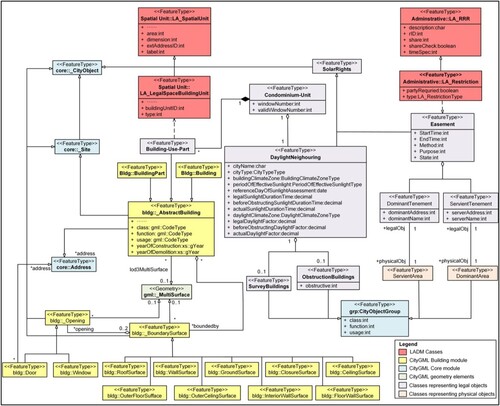
As CityGML itself cannot well describe the property characteristics of 3D entities, and the LADM does not support entity models for constructing the geometry of 3D objects. To solve these problems, the CityGML extension ADE mechanism is used to extend the CityGML building entity model to include legal concepts defined in the LADM (Biljecki, Kumar, and Nagel Citation2018; Schulte and Coors Citation2009). ADEs can create new feature types that may be subtypes of existing types and have new attributes, geometries, and associations (Gröger and Plümer Citation2012). In our study, to facilitate the calculation of sunlight for residential units, the legal and physical objects are attached and combined using the ADE mechanism, by extending the attributes and semantics of CityGML. The legal object is described by its physical counterpart through semantic relationships, which are also implemented using the ADE mechanism. We use the CityGML scale LOD3, which includes physical objects such as windows and balconies, to describe solar rights for residential units. We propose the data model for describing solar rights using the Unified Modeling Language (UML), which is depicted in . The UML diagram includes several packages:
The red UML package represents the legal concepts defined in the LADM, including LA_SpatialUnit, LA_LegalSpaceBuildingUnit, LA_RRR, and LA_Restriction.
The yellow UML package represents the building entity model defined in CityGML, including AbstractBuilding (Building and BuildingPart) and the building classes involved in LOD3.
The green UML package represents the geometry elements defined by GML3, including gml:MultiSurface.
The blue package represents the core CityGML classes, which include CityObject, Site, Address, and CityObjectGroup.
The purple UML package represents the legal object classes in the extension of solar rights, which includes DaylightNeighboring and Easement.
The orange UML package represents the physical object classes in the extension of solar rights.
Figure 5. Spatiotemporal expression model of solar rights in a UML diagram.
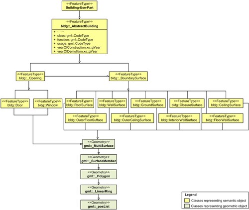
Geometric and semantic integration is required in the model. Each semantic object in a building CityGML LOD3 model, such as walls, roofs, doors, or windows, can be represented by a B-Rep by using gml:MultiSurface geometry (Tang et al. Citation2020). Each combined surface or complex object is made up of multiple surfaces (gml:Surface-Member). Each surface is represented by a polygon (gml:Polygon) object, and the polygon is represented by its outer contour closed ring (gml:LinearRing), which finally forms a coordinate string (gml:posList) composed of vertices connected to the first and last coordinates. Because the vertex coordinates of each extracted semantic surface object are known, it is only necessary to write these coordinate points in counter-clockwise order in the posList of each Polygon. Each semantic object has a distinct gml_id attribute that serves as a key identifier for selection, association, and query. The door and window objects must be attached to a specific wall as the wall’s Opening object, and the affiliation between both doors and windows and the wall is established by the attribute constraint that gml_parent_id equals the attached wall’s gml_id. The geometric structure of each semantic object of the extended CityGML LOD3 model is shown in .
Figure 6. The geometry of semantic objects in the CityGML LOD3 model.
3.2. Legal representation of spatiotemporal model for solar rights
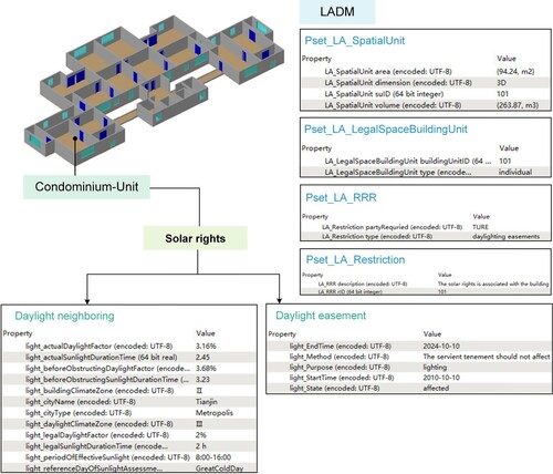
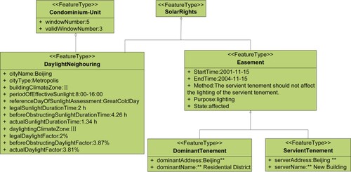
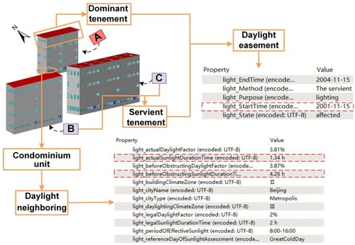
The LA_SpatialUnit, which is the fundamental class of the LADM spatial expression, allows legal objects to be represented in 2D/3D (Lemmen et al. Citation2010). It is used to describe the legal space within a building and is implemented as a subclass of the LA_SpatialUnit, called the LA_LegalSpaceBuildingUnit. An abstract class called Building-Use-Part, which implements the LADM class LA_LegalSpaceBuildingUnit, is created as a subclass of the CityGML abstract feature bldg::_AbstractBuilding (see ) to divide the internal structure of the building from a management/legal perspective. The Condominium-Unit class describes the legal space class of the building and the property unit, expanding the DaylightNeighboring class on its basis.
To clarify the model structure, an abstract class called SolarRights is added to describe solar rights. The SolarRights class inherits from the CityObject class and is refined into two specializations (see ): DaylightNeighboring and Easement. When accurately expressing DaylightNeighboring, it is necessary to consider not only the differences in laws and regulations but also the changes in lighting calculation indices resulting from regional characteristics. Thus, the attributes of DaylightNeighboring are expanded using city scale and building climate zoning standards in accordance with the Code of Urban Residential Area Planning and Design (People’s Republic of China Citation2018). These attributes include the city type, city name, building climate division, reference day of sunlight assessment, period of effective sunlight, legal sunlight duration time, before obstructing sunlight duration time, actual sunlight duration time, legal daylight factor, before obstructing daylight factor, and actual daylight factor.
The LADM permission types LA_RRR and LA_Restriction are constraints on real estate that are realized through an easement because the essence of an easement is a restriction on real estate. To describe daylighting easements, an abstract class called Easement is defined, which is an implementation of the LA_Restriction class in the LADM. Furthermore, two types of rights spaces are created using the feature class core:CityObject, namely, ServientTenement and DominantTenement. The Easement class contains the following attributes: address, method, purpose, state, start time, and end time.
3.3. Physical representation of spatiotemporal model for solar rights
The spatiotemporal model for solar rights is represented physically using various classes and subclasses. The building core feature class _AbstractBuilding is associated with Using-Building-Part, while the condominium-Unit class inherits all the geometry and properties of Using-Building-Part. The DaylightNeighboring class is defined as a subclass of the condominium-Unit, inheriting its functions and defining its attributes. The SolarRights class is implemented through property extension after inheritance, using the XML Schema extension tag.
To describe the sheltering relationship between buildings, the physical entities corresponding to the building to be measured and the shadowed building are included in the neighboring daylight rights. These entities are represented by SurveyBuildings and ObstructingBuildings classes, respectively. The SurveyBuildings class primarily describes the effective sunlight conditions of the building, while the ObstructingBuildings class primarily describes the occlusion time of the building to be measured. Therefore, the ObstructingTime attribute is added, and one or more ObstructingBuildings classes may be contained within the DaylightNeighboring class.
The servient area and dominant area, which correspond to the physical entities of the easements, are represented by the ServientArea class and DominantArea class, respectively. These areas may be 2D parcels or a collection of 3D physical entities. The corresponding physical objects are described using the grp:CityObjectGroup class in CityGML. The CityGML thematic extension module CityObjectGroup allows for the aggregation of arbitrary city objects, which can be used to describe building complexes. The feature classes of SurveyBuildings, ObstructingBuildings, ServientArea, and DominantArea are created as subclasses of the CityGML feature grp:CityObjectGroup in the developed ADE, as illustrated in of the study.
3.4. Association between legal and physical objects
The association between legal and physical objects is an important aspect of the data model. By recording these relationships, the implementation of the model can be facilitated. This is particularly evident in cases involving neighboring daylight rights and daylighting easements, where the relationship between legal and physical objects is clarified.
In the LADM, LA_SpatialUnit, LA_LegalSpaceBuildingUnit, LA_RRR (Rights, Restrictions, and Responsibilities), and LA_Restriction are responsible for mapping the corresponding attribute sets to the attributes of the Condominium-Unit entity. The specific attribute sets associated with these entities are given in , providing detailed information on the attributes that are assigned to the Condominium-Unit entity within the LADM framework.
Table 4. Property sets for basic administrative units and RRR information.
In the context of neighboring daylight rights, there exists a 1:1 relationship between the Condominium-Unit and DaylightNeighbouring. Each residential unit corresponds to a specific legal attribute of neighboring daylight rights. And the Condominium-Unit includes all the number of windows and the number valid for calculating solar rights. The DaylightNeighbouring class encompasses Surveybuildings and ObservationBuildings. Survey buildings or obstruction buildings may consist of one or more related building objects.
Regarding daylighting easements, the easement contract necessitates the inclusion of two essential components: the servient tenement and the dominant tenement. Consequently, a DaylightingEasement object must contain both a ServientTenement object and a DominantTenement object. Furthermore, the physical counterparts of these components, namely ServientArea and DominantArea, are modeled in a 1:1 relationship.
3.5. User-defined attribute types
In order to create a spatiotemporal expression model of solar rights, customized data types are necessary since many of the predefined attributes in CityGML lack the required data types. This is particularly important when dealing with neighboring daylight rights and daylighting easements, as seen in and , which provide optional attribute values for our study. Neighboring daylight rights require expanded attributes for calculating sunlight duration and daylight factor, including the city name, city type, effective sunlight period, sunlight reference day, building climate division, legal sunlight duration, sunlight duration before occlusion, actual sunlight duration, legal daylight factor, daylight factor before occlusion, and actual daylight factor. The expanded attributes provide legal information about solar rights that can be used to determine whether violations have occurred. Similarly, daylighting easements require expanded attributes to specify the method, purpose, state, and easement start/end time. These extended attributes offer a comprehensive legal framework for solar rights, ensuring their protection and preventing potential violations.
Table 5. User-defined data types for neighboring daylight rights.
Table 6. User-defined data types for daylighting easements.
4. Case analysis
Based on an analysis of solar rights cases in China, solar rights disputes can be divided into two main categories: (1) changes in the internal structure of buildings affect the solar rights of residents, and (2) new buildings alter the spatial relationship between buildings, resulting in solar rights disputes. To assist in resolving these disputes, we proposed a spatiotemporal model of solar rights that quantifies the interference of solar rights in these two cases. The experimental process involves the following steps (see ):
The original building data are in DXF format, and the building’s 3D coordinates are extracted for later data conversion.
Two indices are used to calculate solar rights: the sunlight duration and daylight factor. The sunlight duration is calculated using the Tianzheng Sunlight software, with meteorological data from the Tianzheng software database selected for the region. The solar rights analysis standard used is the People’s Republic of China’s national standard, with a base year of 2001. The calculation accuracy is 1 min, and the effective calculation time is the Great Cold Day (8:00 − 16:00). The midpoint of the window surface is analyzed to obtain the sunlight duration of each residential unit’s window. To obtain the final result, we use the method of calculating the sunlight duration based on residential units described in Section 2.2.1. The daylight factor is calculated using Dynamic Daylighting software, with regional meteorological data of EPWmap selected for the calculation process. The effective time of calculation is the Great Cold Day (8:00 − 16:00), and the daylight factor calculation result is thus obtained.
The spatiotemporal expression model of solar rights shown in is used to define the entities of neighboring daylight rights and daylighting easements. The Building XML Schema file defined by CityGML 2.0 is expanded using UML tools, and relevant attribute information is added. The new entities are marked for aggregation, generalization, and association with other standard entity classes, and a new extended model file (*.XSD) is created. In the.XSD file, newly extended classes are represented as complex elements (complexType). The solar rights class implements an attribute extension after inheritance by using the XML Schema extension tag, and the attribute is defined as a simple element (simpleType).
The 3D building model data is converted into GML format with FME software. The.XSD file from step (3) is imported into the header of the CityGML extension file, and Citygml4j is used to reorganize the geometric and semantic information to generate the final CityGML file.
The final CityGML file is visualized, and the attributes of solar rights in the FME software are viewed (see ).
Figure 7. Implementation process.
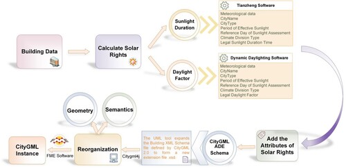
Figure 8. An example of condominium unit with its relevant RRR and solar rights information.
4.1. Impact of internal building changes on solar rights
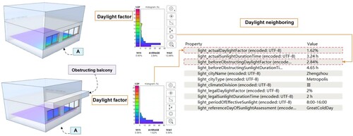
Solar rights disputes can arise in a building when individual household heads illegally construct balconies or other facilities that affect the lighting quality of neighboring households. In such cases, 3D modeling can be used to perform calculations to provide available basis for the forced demolition of illegally constructed entities. To illustrate in Case 1, where residential unit A, located on the tenth floor, experienced reduced lighting due to the illegal extension of balconies by the residents on the eleventh floor. Despite repeated negotiations by residential unit A, the eleventh-floor residents refused to demolish the balcony, citing it as a public space. However, the private construction of the balcony seriously infringed on the solar rights of residential unit A. To assist the judicial department in ordering its compulsory demolition and determining compensation, the degree of infringement on residential unit A can be quantitatively calculated by separately assessing the daylight factor of the residential unit before and after the illegal balcony’s construction.
To demonstrate the efficacy of this method, we simulated the situation of Case 1 and determined the sunlight duration and daylight factor in the area of residential unit A. Our analysis revealed that residential unit A’s direct sunlight duration decreased from 4.65 h to 3.24 h with the illegal balcony’s construction, meeting the national requirement of two hours on the Great Cold Day, but the daylight factor before shading was 2.84%, which decreased to 1.62%, below the minimum standard of 2% after the balcony’s construction, infringing on solar rights. A spatiotemporal model of solar rights, as depicted in , visually represents and expresses the model’s attributes.
Figure 9. Visualization and attribute expression of the solar rights model.
4.2. Spatial alterations and solar rights disputes arising from new buildings
Solar rights disputes arising from newly constructed buildings that affect the lighting quality of surrounding buildings can be addressed by modeling the lighting disturbance caused by the new construction. In such cases, compensation can be based on the degree of infringement on solar rights, as illustrated by Cases 2 and 3.
In Case 2, the lack of a daylighting appraisal report prevented the determination of the degree of occlusion of the surrounding buildings and hence whether Building A’s solar rights were infringed. Our study addresses this issue by simulating the occlusion of the surrounding buildings and quantifying the degree of infringement using a spatiotemporal expression model of solar rights. We consider Building A, which is surrounded by four sheltering buildings (Building B, Building C, Building D, and Building E) as an example (see ). Our analysis shows that Building B has the longest occlusion time (0.5 h) and the greatest impact on the daylighting of Building A. The daylight factor of Building A decreases from 2.98% before occlusion to 2.88% after occlusion, and the sunlight duration decreases from 4.17 h to 1.34 h. These findings provide evidence for litigation and compensation. shows the spatiotemporal model expression of solar rights in Case 2, where the model’s geometric and semantic information is reorganized, and the attributes relating to solar rights are improved. CityGML instance files generated from the model are visualized using software (see ).
Figure 10. Visualization and attribute expression of the solar rights model.
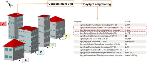
Figure 11. UML diagram of the spatiotemporal expression of solar rights.
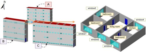
Case 3: A specific case is presented, in which new buildings were constructed on the south side of Residential Building A, and the residents signed a written agreement with the developer that the new buildings would not interfere with the lighting of Residential Building A. However, after the completion of the new buildings, the lighting of the residents of Residential Building A was disrupted, and they filed a lawsuit. The court ruled that the new buildings obtained administrative planning permission and judged that lighting interference was not established. However, daylighting measurements were not performed. This ruling was made without considering the changes in sunlight duration before and after the construction of the new buildings, which violated the solar rights of Residential Building A.
The proposed spatiotemporal expression model of solar rights can simulate the daylighting situation in Case 3 and quantify the degree of daylighting violation, providing strong evidence for the residents of Residential Building A. The residential unit structure diagram on the west side of the first floor of Residential Building A is shown in , and a daylighting easement contract was signed between the two parties prior to the completion of the new buildings. The sunlight duration of the residential unit before and after the occlusion of Building B and Building C was calculated, and the corresponding daylight factors were also calculated.
Figure 12. Area location plan and apartment unit structure drawing.
It is found that the sunlight duration of the residential units of Residential Building A did not meet the relevant regulations’ requirements of two hours of sunshine on the Great Cold Day, thereby infringing on the neighboring daylight rights. The content of the daylighting easement contract signed by both parties indicates that the dominant tenement (residents in Building B and Building C) should not obstruct the lighting of the servient tenement (residents in Building A), but the daylighting of Residential Building A was infringed, indicating a failure to comply with the daylighting easement contract. The spatiotemporal expression model of solar rights in Case 3 is depicted in , which reorganizes the geometric and semantic information of the model, enhances the attributes of solar rights, and generates CityGML instance files that are visualized using FME software (see ). This analysis demonstrates the usefulness of the proposed model in resolving solar rights disputes arising from new construction projects.
Figure 13. UML diagram of the spatiotemporal expression of solar rights.
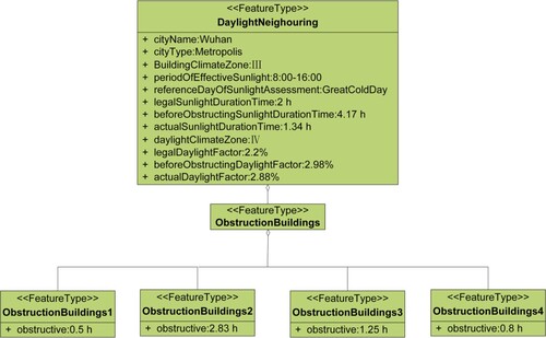
Figure 14. Visualization and attribute expression of the solar rights model.
4.3. Discussion
In this study, we address the spatiotemporal expression of solar rights, which requires consideration of both time and space dimensions. To this end, we introduce two parameters, namely sunlight duration and daylight factor, which represent the temporal and spatial dimensions of solar rights, respectively. Based on an examination of numerous cases, we categorize solar rights disputes into two types: (1) disputes arising from illegally erected obstacles that alter the internal structure of a building and infringe on the solar rights of its residents, and (2) disputes arising from new buildings that alter the spatial relationship between buildings, affecting the solar rights of residents in neighboring buildings.
To validate the effectiveness of the proposed model, three cases were examined, demonstrating its utility in resolving solar rights disputes. In Case 1, we calculate the sunlight duration and daylight factor of residential units before and after the illegal balcony was erected. Although the sunlight duration meets the two-hour standard, the daylight factor falls short of the 2% standard. Our model enables a quantitative calculation of the degree of infringement on solar rights, which can assist the judicial department in determining compensation and ordering the demolition of the balcony. In Case 2, we demonstrate how the spatiotemporal expression of our model can be used to calculate the occlusion time of each obstructing building, thereby determining the degree of infringement on the neighboring building’s daylighting. We record this information in the ObstructionBuildings property. In Case 3, we utilize the spatiotemporal model to express neighboring daylight rights and daylighting easements. The plaintiff’s daylighting was affected after the new building was erected, resulting in the defendant’s violation of the easement contract.
Our study fills the gap in the previous inability to calculate solar rights due to the lack of daylight factor. The proposed model effectively quantifies solar rights in both time and space by considering sunlight duration and daylight factor. With the examination of three cases, this study has shown its significant implications for resolving solar rights disputes in a comprehensive and quantitative manner, providing a reliable framework for determining the degree of infringement on solar rights. Furthermore, CityGML and LADM provide a robust integration of physical objects and legal information, offering advantages in the context of our proposed model.
Moreover, the effectiveness of the proposed spatiotemporal solar rights model is not limited to resolving legal disputes. It can also be extended to other scenarios such as building shading analysis, urban design and planning, and sustainable architecture. For example, the model can aid architects and urban planners in optimizing building design and placement to maximize solar access and minimize shading effects on neighboring buildings. This can contribute to the creation of sustainable and livable urban environments, which are becoming increasingly important as cities continue to grow and face challenges such as climate change and energy efficiency.
5. Conclusions
Solar rights are inherited from the ownership of property and are usually stated in legal texts. It is not trivial to clarify solar rights in urban residential areas, which is a non-negligible factor that leads to many disputes about solar rights. The primary criterion of solar rights is determined by the sunshine time and geographical location of the property, while the position, building structure, and neighborhood are key indices used to calculate the solar rights of a given property. Therefore, building an explicit and available spatiotemporal model is significant for land/construction planning and property management, as it provides an effective and easy tool to avoid or resolve potential conflicts of property ownership.
The goal of this research is to provide a reliable technological means for measuring the degree of infringement of solar rights to assist in the resolution of solar rights disputes. To achieve this, a 3D spatiotemporal model is presented with available spatial and temporal features for measuring solar rights by considering both the sunlight duration and the daylight factor. The sunlight duration is calculated by the relative positions of buildings over time, while the daylight factor is calculated by the surrounding environment and internal structure of the building. Moreover, the definition/concept of rights space in LADM can be extended to CityGML via the CityGML ADE mechanism, which results in the CityGML-LADM ADE model describing the spatiotemporal data of solar rights. This model is based on the existing building property rights structure model, which can be used to manage building property rights and solar rights information in a unified manner.
It is worth noting that solar rights are characterized by geography and social culture. This research is conducted in the context of the legal system of China where solar rights are defined and modeled. Thus, the proposed model provides an available reference paradigm for other legal systems. However, the calculation of the daylight factor in principle involves various types of interior materials of buildings. In this study, only the common type of building materials is considered. In addition, the solar rights on the shared or common property are not considered. In the implementation of the proposed model, the effectiveness of calculation and access to data storage should be given much attention. These topics will orient our future work.
Data availability statement
The data that support the findings of this study are available from the corresponding author upon reasonable request.
Disclosure statement
No potential conflict of interest was reported by the author(s).
Correction Statement
This article has been corrected with minor changes. These changes do not impact the academic content of the article.
Additional information
Funding
Notes
1 The Great Cold, also known as the 24th solar term, occurs from January 20th to February 4th and represents the final solar term of winter in the annual lunar calendar. This period is characterized by severe weather conditions including snow, rain, and intense cold, which significantly impact daily life. Specifically, the Great Cold Day corresponds to January 20th.
References
- Agugiaro, G., J. Benner, P. Cipriano, and R. Nouvel. 2018. “The Energy Application Domain Extension for CityGML: Enhancing Interoperability for Urban Energy Simulations.” Open Geospatial Data, Software and Standards 3 (1): 1–30. https://doi.org/10.1186/s40965-018-0042-y.
- Ahmad, L., R. H. Kanth, S. Parvaze, and S. Mahdi. 2017. “Measurement of Sunshine Duration.” In Experimental Agrometeorology: A Practical Manual, 37–39. Springer, Cham. https://doi.org/10.1007/978-3-319-69185-5_6.
- Aien, A., M. Kalantari, A. Rajabifard, I. Williamson, and R. Bennett. 2013. “Utilising Data Modelling to Understand the Structure of 3D Cadastres.” Journal of Spatial Science 58: 215–234. https://doi.org/10.1080/14498596.2013.801330.
- Aien, A., M. Kalantari, A. Rajabifard, I. Williamson, and J. Wallace. 2013. “Towards Integration of 3D Legal and Physical Objects in Cadastral Data Models.” Land Use Policy 35: 140–154. https://doi.org/10.1016/j.landusepol.2013.05.014.
- Arecchi, A. V., T. Messadi, and R. J. Koshel. 2007. Field Guide to Illumination. Bellingham: SPIE Press. https://doi.org/10.1117/3.764682.
- Atazadeh, B., L. Halalkhor Mirkalaei, H. Olfat, A. Rajabifard, and D. Shojaei. 2021. “Integration of Cadastral Survey Data Into Building Information Models.” Geo-spatial Information Science 24 (3): 387–402. https://doi.org/10.1080/10095020.2021.1937336.
- Bai, L., and S. Wang. 2019. “Definition of New Thermal Climate Zones for Building Energy Efficiency Response to the Climate Change During the Past Decades in China.” Energy 170: 709–719. https://doi.org/10.1016/j.energy.2018.12.187.
- Bakirci, K. 2009. “Models of Solar Radiation with Hours of Bright Sunshine: A Review.” Renewable and Sustainable Energy Reviews 13: 2580–2588. https://doi.org/10.1016/j.rser.2009.07.011.
- Biljecki, F., K. Kumar, and C. Nagel. 2018. “CityGML Application Domain Extension (ADE): Overview of Developments.” Open Geospatial Data, Software and Standards 3: 13. https://doi.org/10.1186/s40965-018-0055-6.
- Blut, C., and J. Blankenbach. 2021. “Three-dimensional CityGML Building Models in Mobile Augmented Reality: A Smartphone-Based Pose Tracking System.” International Journal of Digital Earth 14 (1): 32–51. https://doi.org/10.1080/17538947.2020.1733680.
- Bronin, S. C. 2009. “Solar Rights.” BUL Rev 89: 1217. https://www.bu.edu/law/journals-archive/bulr/documents/bronin.pdf.
- Bronin, S. C. 2015. “Solar Rights in the United States.” In Delivering Energy Policy in the EU and US: A Multi-Disciplinary Reader, edited by Raphael Heffron and Gavin Little. Edinburgh University Press. Available at SSRN: https://ssrn.com/abstract=2606015.
- Drobež, P., M. K. Fras, M. Ferlan, and A. Lisec. 2017. “Transition from 2D to 3D Real Property Cadastre: The Case of the Slovenian Cadastre.” Computers, Environment and Urban Systems 62: 125–135. https://doi.org/10.1016/j.compenvurbsys.2016.11.002.
- Dynamic Daylighting software. 2021. https://drajmarsh.bitbucket.io/daylight-box.html.
- Fernández, M. E., J. O. Gentili, and A. M. Campo. 2022. “Solar Access: Review of the Effective Legal Framework for An Average Argentine City.” Renewable and Sustainable Energy Reviews 156: 112008. https://doi.org/10.1016/j.rser.2021.112008.
- Góźdź, K., W. Pachelski, P. van Oosterom, and V. Coors. 2014. “The Possibilities of Using CityGML for 3D Representation of Buildings in the Cadastre.” Proceedings of the 4th International Workshop on 3D Cadastres, Dubai, UAE 9-11. https://www.fig.net/resources/proceedings/2014/2014_3dcadastre/3Dcad_2014_34.pdf.
- Gröger, G., and L. Plümer. 2012. “CityGML – Interoperable Semantic 3D City Models.” ISPRS Journal of Photogrammetry and Remote Sensing 71: 12–33. https://doi.org/10.1016/j.isprsjprs.2012.04.004.
- Hong, L., X. Zhang, and J. Du. 2021. “35th PLEA Conference on Passive and Low Energy Architecture (PLEA 2020).” Proc. PLEA 2020, 35th International Conference on Passive and Low Energy Architecture 1: 517–522.
- Hraška, J. 2019. “Approaches, Methods and Tools of Rights of Access to Sunlight Around the World.” Slovak Journal of Civil Engineering 27 (4): 45–52. https://doi.org/10.2478/sjce-2019-0031.
- Huang, X. 2011. “Understanding and Discussion on the Right of Daylighting in China.” Legal System and Society 26: 289–290. https://doi.org/10.19387/j.cnki.1009-0592.2011.26.151.
- ISO19152. 2012. “Geographic Information - Land Administration Domain Model (LADM).” https://www.iso.org/standard/51206.html.
- Iversen, A., N. Roy, M. Hvass, M. Jørgensen, J. Christoffersen, W. Osterhaus, and K. Johnsen. 2013. Daylight Calculations in Practice: An Investigation of the Ability of Nine Daylight Simulation Programs to Calculate the Daylight Factor in Five Typical Rooms. Aalborg, Denmark: Danish Building Research Institute, Aalborg University, 26. https://vbn.aau.dk/en/publications/daylight-calculations-in-practice-an-investigation-of-the-ability.
- Jacobson, H., A. Carlson, and M. Lindahl. 2021. “Legal, Environmental and Economic Issues with Functional Sales – A Case of Indoor Lighting.” Journal of Cleaner Production 298: 126713. https://doi.org/10.1016/j.jclepro.2021.126713.
- Kolbe, T. H., G. Gröger, and L. Plümer. 2005. “CityGML: Interoperable Access to 3D City Models.” In Geo-Information for Disaster Management, edited by P. van Oosterom, S. Zlatanova, and E. M. Fendel, 883–899. Berlin, Heidelberg: Springer. https://doi.org/10.1007/3-540-27468-5_63.
- Lee, S., and K. S. Lee. 2020. “Optimization of Apartment-Complex Layout Planning for Daylight Accessibility in a High-Density City with a Temperate Climate.” Energies 13 (16): 4172. https://doi.org/10.3390/en13164172.
- Lemmen, C. H. J., P. J. M. V. Oosterom, R. J. Thompson, J. P. Hespanha, and H. T. Uitermark. 2010. “The Modeling of Spatial Units (Parcels) in the Land Administration Domain Model (LADM).” XXIV FIG International Congress 2010: Facing the Challenges - Building the Capacity, April 2010. http://www.gdmc.nl/publications/2010/Spatial_Units_in_LADM.pdf.
- Lemmen, C., P. Van Oosterom, and R. Bennett. 2015. “The Land Administration Domain Model.” Land Use Policy 49: 535–545. https://doi.org/10.1016/j.landusepol.2015.01.014.
- Li, L., Y. Lei, L. Tang, F. Yan, F. Luo, and H. Zhu. 2019. “A 3D Spatial Data Model of the Solar Rights Associated with Individual Residential Properties.” Computers, Environment and Urban Systems 74: 88–99. https://doi.org/10.1016/j.compenvurbsys.2018.12.003.
- Li, L., J. Wu, H. Zhu, X. Duan, and F. Luo. 2016. “3D Modeling of the Ownership Structure of Condominium Units.” Computers, Environment and Urban Systems 59: 50–63. https://doi.org/10.1016/j.compenvurbsys.2016.05.004.
- Ma, J., and B. Chen. 2014. Property Law.. Shanghai, China: Fudan University Press. http://www.fudanpress.com/news/showdetail.asp?bookid=9802.
- OGC. 2012. “Geography Markup Language (CityGML) Encoding Standard.” https://www.ogc.org/standard/CityGML/.
- People’s Republic of China. 2007. “The Real Right Law of People's Republic of China.” https://www.unil.ch/files/live/sites/cda/files/users/mlerach/public/Sachenrechtsgesetz_China.pdf.
- People’s Republic of China. 2013. “Standard for the Daylighting Design of Buildings.” http://www.codeofchina.com/standard/GBT50033-2001.html.
- People’s Republic of China. 2018. “Code of Urban Residential Area Planning and Design.” https://www.chinesestandard.net/PDF/English.aspx/GB50180-2018.
- People’s Republic of China. 2021. “Civil Code of the People's Republic of China.” http://english.www.gov.cn/archive/lawsregulations/202012/31/content_WS5fedad98c6d0f72576943005.html.
- Rajabifard, A., B. Atazadeh, and M. Kalantari. 2018. “A Critical Evaluation of 3D Spatial Information Models for Managing Legal Arrangements of Multi-Owned Developments in Victoria, Australia.” International Journal of Geographical Information Science 32 (10): 2098–2122. https://doi.org/10.1080/13658816.2018.1484125.
- Rönsdorf, C., D. Wilson, and J. Stoter. 2014. “Integration of Land Administration Domain Model with CityGML for 3D Cadastre.” Proceedings of 4th International Workshop on 3D Cadastres, Dubai: International Federation of Surveyors (FIG) 313–322. https://repository.tudelft.nl/islandora/object/uuid:64324ca8-b3a5-4160-8c58-5da1dfe6ac9d?collection=research.
- Schulte, C., and V. Coors. 2009. “Development of a CityGML ADE for Dynamic 3D Flood Information.” F.-J. Behr, D. Schröder, & AP Pradeepkumar (Eds.) 103: 10. https://www.researchgate.net/profile/Jagath-Gunatilake/publication/309443092_Identification_and_mapping_of_spatial_distribution_of_Floating_aquatic_plants_in_tanks_using_remote_sensing_and_GIS/links/5810e3c208aef2ef97b2cfdf/Identification-and-mapping-of-spatial-distribution-of-Floating-aquatic-plants-in-tanks-using-remote-sensing-and-GIS.pdf#page=22.
- Seong, Y.-B., J.-H. Lim, M.-S. Yeo, I.-D. Goh, and K.-W. Kim. 2006. “HELIOS: Solar Rights Analysis System for Apartment Buildings.” Solar Energy 80: 723–741. https://doi.org/10.1016/j.solener.2005.11.008.
- Shojaei, D., A. Rajabifard, M. Kalantari, I. D. Bishop, and A. Aien. 2015. “Design and Development of a web-Based 3D Cadastral Visualisation Prototype.” International Journal of Digital Earth 8 (7): 538–557. https://doi.org/10.1080/17538947.2014.902512.
- Sudan, M., G. Tiwari, and I. Al-Helal. 2015. “A Daylight Factor Model Under Clear Sky Conditions for Building: An Experimental Validation.” Solar Energy 115: 379–389. https://doi.org/10.1016/j.solener.2015.03.002.
- Sun, G. 2006a. “The Deciding and Statutory Rights of Daylighting.” Xiamen University Law Review 2: 227–260. http://www.cqvip.com/qk/71455x/2006002/668887076200602009.html.
- Sun, G. 2006b. Research on Theory and Practice of Right to Light.. Xiamen, China: Xiamen University. http://dspace.xmu.edu.cn:8080/dspace/handle/2288/22945.
- Tang, L., S. Ying, L. Li, F. Biljecki, H. Zhu, Y. Zhu, F. Yang, and F. Su. 2020. “An Application-Driven LOD Modeling Paradigm for 3D Building Models.” ISPRS Journal of Photogrammetry and Remote Sensing 161: 194–207. https://doi.org/10.1016/j.isprsjprs.2020.01.019.
- Tianzheng Sunlight software. 2003. http://tangent.com.cn/.
- Tregenza, P. 1989. “Modification of the Split-Flux Formulae for Mean Daylight Factor and Internal Reflected Component with Large External Obstructions.” Lighting Research & Technology 21: 125–128. https://doi.org/10.1177/096032718902100305.
- Turan, I., A. Chegut, D. Fink, and C. Reinhart. 2020. “The Value of Daylight in Office Spaces.” Building and Environment 168: 106503. https://doi.org/10.1016/j.buildenv.2019.106503.
- Van Oosterom, P., and C. Lemmen. 2015. “The Land Administration Domain Model (LADM): Motivation, Standardisation, Application and Further Development.” Land Use Policy 49: 527–534. https://doi.org/10.1016/j.landusepol.2015.09.032.
- Wolters Kluwer Legal Information Database. 2011. https://law.wkinfo.com.cn/.
- Yang, Z. 2013. “Researches of Legal Issues of Architecture Under Planning Permission Against Neighbors’ Right of Lighting.” Theory of Science 31: 161–163. https://doi.org/10.3969/j.issn.1002-2589.2013.31.065.
- Yang, L., J. C. Lam, and C. L. Tsang. 2008. “Energy Performance of Building Envelopes in Different Climate Zones in China.” Applied Energy 85 (9): 800–817. https://doi.org/10.1016/j.apenergy.2007.11.002.
- Yun, P. 2010. Lighting Environment Simulation of Building. Beijing, China: China Construction Industry Press.
- Zielinska-Dabkowska, K. M., and K. Xavia. 2019. “Protect Our Right to Light.” Nature 568: 451–453. https://doi.org/10.1038/d41586-019-01238-y.