
 ?Mathematical formulae have been encoded as MathML and are displayed in this HTML version using MathJax in order to improve their display. Uncheck the box to turn MathJax off. This feature requires Javascript. Click on a formula to zoom.
ABSTRACT
Mean sea level rise (SLR) could increase up to 2m by 2100, which would see damage caused by coastal flooding in Europe increase from €1.25bn per annum currently to €961bn in just over 80 years. Urban areas situated along the North Sea coastline are particularly vulnerable to extreme sea level rise (a combination of SLR, tide, and storm surges). The main goal of this study is to assess the paradigm shift in flood risk management from reducing probability of the flood event to reducing its consequences in the city of Vlissingen, in the Netherlands. Two spatial adaptation strategies are modeled and compared by using spatial, climatic, and socioeconomic projections for the year 2100: the “Vlissings Model” and the “Spuikom Model.” The Vlissings Model is about increased coastal protection through the heightening of existing grey infrastructure by 3 m, which includes the dike and buildings constructed on top of it. The Spuikom Model is accepting and rerouting overtopping water towards an existing former backshore water basin. The study brings forth an interdisciplinary “Design & Assess” framework that brings together design strategies with flood damage models and cost/benefit analyses to compare the effectiveness of two paradigms in dealing with extreme SLR.
1. Introduction
Mean sea level rise (SLR) could increase up to 2 m by 2100 (Oppenheimer et al. Citation2019), which would see damage caused by coastal flooding in Europe increase from €1.25bn per annum currently to €961bn in just over 80 years (European Commission, Citation2018). Urban areas situated along the North Sea coastline are particularly vulnerable to extreme SLR (a combination of SLR, tide, and storm surges).
The present prevailing flood risk management paradigm in which the risk is assessed by probability x consequences, is aiming for reducing the probability of a flood event to occur, largely by means of grey infrastructure. Flood risk is the likelihood of a flood event together with the actual damage to human health and life, the environment and economic activity associated with that flood event. Risk can be defined as a function of hazard, exposure, and vulnerability. Hazard, the amount of water in cubic meters over time, represents the probability and intensity of a threatening natural event (Kron Citation2005; Merz et al. Citation2010); the hazard occurrence refers to the frequency of the returning period at a given magnitude (Peduzzi et al. Citation2009). The exposure, the amount of economic value exposed, can be defined as the degree to which element-at-risk is exposed to hazards (Kaźmierczak and Cavan Citation2011); vulnerability is the degree of loss to each element-at-risk under a given severity of hazard (Peduzzi et al. Citation2009). However, there is a paradigm shift recognizable in flood risk management wherein the reduction of the consequences is also a feasible and acceptable approach as a manner of reducing the risk. Instead of exposure and vulnerability reduction by means of grey infrastructure, consequences are reduced by adapting the urban environment. Moreover, the reduction of the vulnerability is addressed by looking into the balance between, on the one hand, natural conditions and on the other man-made interventions. Just keeping up the hard line of flood defence is spatially and financially not possible anymore, due to corsets or the urban functions and quality in place, costs of new infrastructure or loss of value due to the implementation of the latter (Vries and de & Wolsink Citation2009). Beyond that, the ambition of living with water or adaptivity is a strong societal driver to divert from the current paradigm of flood protection that is based in only reducing the probability.
This paper presents the results of an interdisciplinary design study in which the impact of the paradigm shift – from reduction of the probability to the reduction of the consequences – for the case of Vlissingen (NL) is investigated. What does this paradigm shift practically mean when spatial adaptation, and design, by including and Nature Based Solutions (NBS) becomes part of the flood risk management strategy? The reduction of the probability is represented in a (defence) line, the dike, whilst the reduction of the consequences is the spatial design of the coastal, urban zone. This work builds on the idea that by integrating a thorough hydraulic knowledge into urban design it is possible to introduce spatial and urban qualities that can increase resilience to urban flooding.
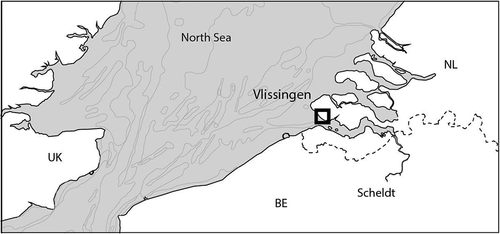
The case study selected for the purpose of the analysis is Vlissingen, in the Netherlands. Vlissingen is a city of almost 50.000 inhabitants southwestern Netherlands located in an area with a high risk of flooding where the North Sea and the Scheldt River come together (). The estuary acts as a funnel, yet due to the proximity of the shipping route (North Sea – Antwerp) seaward reinforcement in the foreshore is not possible. Meanwhile, the dike currently protecting the city is completely fixed with buildings constructed on top of it. In the past, to deal with this complex condition, decision-makers and policymakers have focused on technical solutions, such as the use of reinforced concrete seawall, a heavy engineering and grey infrastructure, as opposed to working with the spatial development in the city. The municipality has also adopted an innovative local building code to regulate that new constructions built on top of the dike will be integrated into eventual future raising of the defence structure (Stronkhorst et al., Citation2012; Vlissingen & Ma.an, Citation2010). This quite progressive policy is called the Vlissings Model. However, this continues the paradigm of keeping the line of defence. These buildings as part of the raised grey infrastructure have a major impact on the urban quality of Vlissingen, because it will replace its historical front-line buildings and block the self-evident relation to the sea. For this reason, the municipality is now examining the approach to reduce the consequences by accepting overtopping: the Spuikom Model. This approach will anticipate urban development wherein space is created to store overtopping behind the defence line, in a former spuikom, sluice system, area (). This is a clear example of the flood defence strategy that moves from holding the line to coastal zone management. It is important to note that this is a local approach to flood risk management, which obviously needs to be coordinated with the regional approach. The scaling up of this strategy is discussed below.
Figure 1. The location of Vlissingen (Netherlands) in the maritime system.
In order to examine the implications of the paradigm shift in flood risk management, a case study research approach is used to test an interdisciplinary Design & Assess (D&A) framework []. The framework comprises: i) the design of different strategies of urban transformation and spatial adaptation; ii) the hydrodynamic modeling, which simulates potential flood events combining sea level rise and extreme flood events and; iii) the damage modeling, which estimates and compare potential flood damages, and, ultimately, iv) the cost-benefit assessment (CBA). Results of our analysis are provided for the Vlissings model – heightening the dike –, the Spuikom Model – accepting and rerouting water runoff –, and a “no-measures” strategy. Although our hydrodynamic modeling is the standard for flood risk assessment, and many methodologies are discussed in the scientific literature (Gallien et al., Citation2018; de Moel et al., Citation2015; Ramirez et al., Citation2016; Vousdoukas et al., Citation2016), the way it is combined with urban design strategy and damage assessment tools can be considered novel. The paper is organized as follows: section 2 presents data and methods used for building the interdisciplinary D&A framework; section 3 presents the results of our analysis for the three strategies; section 4 provides a comparative cost/benefit analysis for the models; section 5 concludes discussing the impact of the paradigm shift from reduction of the probability to the reduction of the consequences in flood risk adaptation in the case of Vlissingen.
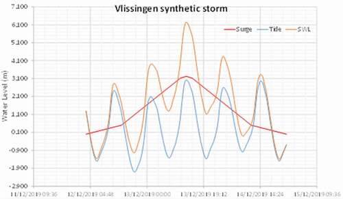
Figure 2. Synthetic storm surge for Vlissingen using the still water level (SWL) from HydraNL (10,000 year RP and 2100 climate change scenario W+) (elaboration: A. Diaz).
2. Design & asses framework
This section describes the construction of the D&A Framework which is the result of a co-design process of data collection and analysis. First, it presents the general framework in which this interdisciplinary collaboration was set up and conducted, using urban design strategies as an integrative tool of projection and evaluation of alternative flood defense strategies vis à vis projections of extreme sea level rise for the year 2100. At this stage, continuous exchange with hydraulic engineers and models, but also public managers and plans, are at the heart of the urban design process. Second, it introduces the hydrodynamic model, its underlying assumptions, the input data, and the boundary conditions that were imposed. Third, it explains the flood damage model, combining the hydrodynamic model and land-use map to calculate flood damages for the two strategies. Last step is the Cost Benefit Assessment (CBA), which as a decision-making step is important because the difference between the CBA of infrastructure projects, like dikes, and CBA of urban area development is a reason why integration of the both is difficult. Acknowledging the difference is the first step and the results will show how to be able to do this.
2.1. The design strategies
Design is about creating a prospective strategy that proposes a possible or desired situation in the future. This future is usually described by goals and targets which are set and established by assumed events between the current and future situation. Design strategies are projective tools widely used in the urban design and planning field to perform cyclical processes of production and comparison of alternative spatial configurations (Deming & Swaffield Citation2011). More in general, the what-if strategy is a common technique to forecast and assess the impact of decision-making choices with respect to opportunities and risks each choice may have on the future (Mietzner and Reger Citation2005). The construction of a prospective strategy, especially as part of Research by Design (de Jong and Van Der Voordt Citation2002) supports the development of strategies to overcome discrepancies between the current and desired future. This is also referred to as “design thinking,” because it is a process built on the representation of the values of the goals and targets by use of visual representation. Some authors even call visualization tools “the mother of all design tools,” because they are used in every stage of a design thinking process (Haasnoot et al. Citation2012). To integrate the flood risk into urban design, hydraulic modeling needs to be part of the design process and visualized in relation to the spatial morphology. Hugh Dutton (Citation2000) argues on the integrated approach to design: ‘For an integrated approach to design, borders between the distinct professional, industrial, and construction territories must be transgressed. The success of this exploration depends on architects’ understanding of the capacities and constraints of each separate field during the design process.”
Therefore, the first step in the construction of the D&A framework comprises the definition of the design strategies under study. In the study, the strategies are used in two ways. First, to project the spatial consequences for the urban coastal area of Vlissingen of two flood risk management strategies. The first strategy is the Vlissings Model, which in line with the prevailing paradigm foresees the heightening of the dike, and the second strategy Spuikom Model, representing the paradigm shift to accepting and rerouting overtopping water. To do so, the spatial implications were designed based on the hydraulic modeling and at the same time discussed with the municipal design and engineering departments to integrate into account the past and present urban dynamics. Second, the strategy technique is used to compare the impact of extreme flood events and perform a cost-benefit analysis for these different spatial adaptation strategies. For this reason, the strategies were elaborated from the beginning in close collaboration with hydraulic engineers. Indeed, the strategies provided the basis to run the hydrodynamic and damage modeling and conduct the comparative analysis.
As such, the design strategies have fully worked as an integrative tool that enabled to bridge knowledge from different disciplines into the definition and research for a solution to the design problem. they integrated current policy and public objectives and visions with the technical knowledge from the hydraulic field.
2.2. The hydrodynamic model
The second step of the D&A framework concerns the elaboration of the hydrodynamic model. Delft3D-FLOW is a hydrodynamic model which calculates non-steady flow and transport phenomena that result from different hydro meteorological conditions like tidal and meteorological forcing on a rectilinear or a curvilinear grid (Deltares, 2020). To do so, this model needs a minimum of three inputs: 1) the bathymetry/topography, 2) the surface roughness coefficient and 3) the boundary conditions. For the purpose of this study, we obtain the terrain elevation from the AHN2 and AHN3 digital elevation model (water boards, provinces, and Rijwaterstaat) and by filtering cars, trees, and roofs of the buildings with a ~50 cm resolution. buildings were included while trees and cars were removed. Subsequently, a rectangular square regular mesh was overposed with a total of around 1.5 million nodes and 2 m resolution over the perimeter of the waterfront and urban center of Vlissingen. For what concerns the surface roughness, and in order to reduce the complexity of the model, an equivalent manning coefficient of 0.025 is adopted, which can be a reasonable value for urban studies (Bricker et al. Citation2015).
As for the boundary conditions, the overtopping discharge flow values produced by a storm with return period (RP) of 10,000 and climate change (CC) extreme scenario W+ at the year 2100 (Vellinga et al. Citation2009) were taken into account. This scenario considers a sea level rise of 1 m by 2100 and a RP 1:10.000; these values are taken to perform the comparison between the current situation (baseline strategy) and two alternative models for coping with sea level rise. The formulas were selected from the EurOtop manual to obtain the overtopping discharge flow for a dike type and coastal morphology similar to those found in Vlissingen (see section 5 “Coastal dikes and embankments dikes” of EurOtop, Citation2018). The overtopping formula for these types of dikes is summarized in equation 5.10 of the manual (Equation 1):
Where:
is a reduction factor according if there is a berm or not;
is a reduction factor for elements that create macro roughness and energy losses;
is a reduction factor to account the angle when waves are not hitting completely perpendicular to the structure (worst case);
is a reduction factor when walls with especial elements are installed over the dike (in Vlissingen a bullnose wall);
is the significant wave height also known as hsig (m);
is the Iribarren number;
is the freeboard (m); q is the overtopping discharge flow (m3/s/m).
Two main variables of this formula – the wave height and still water level (SWL – the elevation that the water can reach due to the storm source and astronomical tide) – are characteristic for each individual storm. Following Deltares (2017), the HydraNL program was used to define these variables for particular storms with different return periods and climate change conditions (according to the boundary conditions). Using these variables, it was possible to obtain a unique overtopping value. Yet, a storm does not produce a unique uniform discharge flow, but it starts with a lower intensity and increases in time until reaching a maximum intensity with higher overtopping discharge flows [see ]. For this reason, the synthetic storm surge model proposed by Deltares (2017) was adopted. Combining values from the EurOtop manual with the synthetic storm surge, it was possible to generate a continuous hydrodynamic simulation of the overtopping discharge flow. As the final stage of the process, overtopping values were associated with every mesh of the DSM described above in order to obtain the hydrodynamic model. It is important to state the spatial scale limitations of this model. We assume that the dunes to the west of the Boulevard maintain their integrity and are not breached by any storm, thereby preventing overtopping at that location. We also assume that east of the lighthouse and pilot boat basin, incident waves are significantly reduced in height, because the shoreline here is sheltered from the westerly incident waves by the boat basin and its jetties, east of which the shoreline normal points south-southeast, preventing significant overtopping there.
2.3. The flood damage model
The third step of the D&A Framework concerns the flood damage model. This model combines the hydrodynamic model with land-use maps to calculate flood damages for the different strategies. Flood damage models aim to estimate what are the possible consequences of the floods following the principle that risk is a function of hazard, exposure, and vulnerability (de Moel et al. Citation2015). In the Netherlands, large-scale flood impacts from major watercourses are commonly assessed with the “Standard Damage and Fatality Model” (in Dutch “Standard Schade en slachtoffer module” or SSM) (Kok et al. Citation2005).Footnote1 It is based on a unit-loss method in which damage per category is assessed by multiplying a damage factor with the maximum flood damage for that category. The economic damage S (expressed in monetary terms) can be calculated by equation (2).
is the “damage factor” for category,
is the number of units (e.g. land use type or houses) in category and
is the maximum damage per unit in category. The damage factor represents the effect of hydraulic conditions and is affected by the maximum water depth and other flood characteristics (Kok et al. Citation2005; Diaz Loaiza et al., Citation2022). The SSM 2017 is used to calculate the direct economic damage (Jonkman and Vrijling, Citation2008; Rijkoverheid Citation2020) including land use types, objects (e.g. cars) and the number of inhabitants, business interruption, and interruption of housing service. Business interruption relates to six categories of business: meeting facility, industry, education, health service, shops, and offices. The maximum damage value related to business interruption depends on the damage factor for the damage to capital goods. The net added-value (to account for the reduction in depreciation) and gross added-value (to account for the depreciation of the non-damaged capital goods) were both taken into account in the maximum damage calculation equation (Deltares, 2015). It should be noted that the interruption duration (flood duration plus restoration period) was assumed as 1 year for all business categories in this method. Moreover, the substitution factor and cascading effects were also considered in the form of multiplier in the calculation (Deltares, 2015). For the interruption of housing services, the gross added value from housing services is supposed to be equal to the production value. i.e. the rent. Bruijn, K. et al., Citation2015 show that the value of housing services is 4.5% of the value of the house and grounds, which is equal to the value added within the sector ‘rental of real estate.’ The average value of residence in the Netherlands for the year 2011 was estimated at 237,000 euro according to CBS data and the maximum damage to furnishing was proposed as 70,000 euro per household. It should be noted that SSM 2017 calculated the maximum damage based on the price in 2011.
Where:
= Total damage due to business interruption of all damage categories [million euro]
= damage factor based on the damage function of the direct physical damage, for damage category
. [-]
= net added value for damage category
[million euro/year]
= gross added value for damage category
[million euro/year]
= damage factor based on the damage function for the business interruption [-]
ID = maximum interruption duration of the damaged object (set to 1 year for all categories)[year]
= Substitution factor for damage category
[-]
= multiplier for indirect damages for damage category
The number of fatalities is calculated by multiplying the number of inhabitants per grid cell by the mortality rate. The mortality rate is determined by the flood characteristics (i.e. water depth, the rising rate of the flood water and water velocity) in the Netherlands, in which the water depth is a dominant factor to determine the fatalities. Other maximum damage per unit category and the associated damage function are standardized in the Netherlands and the land use information is already included in SSM2017. Other information and details about the corresponding damage functions can be found in (de Bruijn et al. Citation2015; Slager and Wagenaar Citation2017). The only required input for SSM 2017 is a flood map, which is supposed to provide flood characteristics of inundation depth, water flow velocity and water rising rate, etc. The inundation depth is a compulsory input with a required format of raster.
2.4. Cost Benefit Assessment (CBA)
In order to evaluate the three strategies and get a grip on what the paradigm shift towards reducing consequences means, the Cost Benefit Assessment (CBA) is the last step in the D&A Framework. The first problem in preparing the CBA is that, whereas data for assessing the damage and predicting costs (financial ratio) of a new dike is available and the calculation is quite straightforwardly done with the existing models, when the flood protection is expanded from a dike to an urban area, another type of CBA is needed that is commonly applied to urban area development. For infrastructure projects, the direct effects are paramount, while in area development the indirect and external effects of projects are central (Priemus Citation2011). To reveal this difference and highlight how this affects decision-making in flood risk management, the D&A framework differentiates the CBA of flood protection (being quantitative) from the CBA for area development (being qualitative).
2.4.1. CBA flood protection
The benefit and cost ratio (Equation 4) for the flood protection infrastructure project is used to represent the economic efficiency in terms of the relative benefits per euro invested in an intervention. The cost is the initial cost investment and annual maintenance cost for each intervention. The benefit is expressed as the reduced expected annual damage (EAD) compared to the baseline strategy. If the benefit/cost ratio is more than 1, it was seen as an economically attractive intervention.
Where Bt is the benefit of an intervention in year t; Ct is the cost in year t, including the initial investment and annual cost; r is the discount rate; and the investment horizon is T years (i.e. the 80 year-period from 2020 to 2100).
In order to use a monetary metric to estimate the benefit of each intervention, it is necessary to quantify the value of life in a monetary term. Although it is still controversial to quantify human life in an ethical domain, from an economic perspective, the monetization of human life has been used by ones who are interested in measuring social benefits associated with investment in particular programs to prevent loss of life (Department of the Prime Minister and Cabinet, O. of B. P. R. Citation2018). Here, in this paper, we quantify the life value by the equal investment to avoid loss of life, also refers to the value of preventing fatality. The value of life was estimated at 10 million euro (Hultkrantz and Svensson Citation2012). Likewise, the investment to avoid an affected person was estimated at 0.5 million euro; subsequently, the number of the affected people could be converted into the monetary term by the number of affected people multiplied by the investment to avoid. Since the flood damage was calculated at the price level of 2011 (in the Dutch damage model), the 2011 price should be converted into present value (PV) using Equation (5).
Where Dpv is the damage at the current year; D2011 is the flood damage at 2011 price. t is the year period between 2011 and current year. If 2021 is taken as current year, t = 10; the Dutch discount rate was adopted as 5.5% (CBP, Citation2017). While, in order to include uncertainty analysis, a lower bound discount rate of 4% and a higher bound of 7% are employed, respectively.
The cost of heightening the dike (per meter) in the urban area of the Netherlands was estimated at 18–21.6 million euro/km and the maintenance cost was estimated at approximately 0.1 million euro/km per year at price level of 2009 (Hillen et al. Citation2010).
2.4.2. CBA of area development
As stated in the introduction, CBA in spatial planning (the overarching field of area development) does not only consider the direct effects of projects as paramount, but also the indirect and external effects of the area development over a longer period of time. This is because area developments consist of several components, which are decided differently by different parties. These are private parties and different levels of government, which means that interests are different and have an impact on the CBA, some benefits are at a different level of scale. Where the national government puts the national interest of flood risk management first, the provinces and municipalities are primarily concerned with the development of the spatial quality of their own region. As a result, provinces and municipalities often have difficulty with (standard) CBA, in which regional effects (employment, business location) do not contribute to the local balance of costs and benefits but are referred to as interregional redistribution effects. A number of the possible effects induced by area developments are difficult to measure and monetize, such as landscape, cultural history, and urban improvements. Not only because market prices are often missing here, but also because sometimes even unambiguous judgments (intervention-effect relationships or dose-effect relationships) are missing. In addition, it can be difficult to determine whether and to what extent the cohesion between the components of an area development provides added value. For example, agglomeration or synergy effects are still difficult to appreciate. However, these are precisely the arguments for a specific course in area development.
In general, the CBA of area development is done by the following steps (Romijn and Renes Citation2015):
problem analysis
baseline strategy (no interventions)
define policy alternatives
determine effects and benefits
determine costs
analysis of variants and risks
overview of costs and benefits
presentation of results
The determination of effects is done by comparing the baseline strategy with the policy alternatives, the effects are categorized in spatial quality effects and welfare effects. Important for area development is that also the effects of project’s measures are studied and valued. How do the different measures synergize into a greater effect? The spatial effects of an area development like landscape quality, architectural history, aesthetics is difficult to measure in quantitative terms, also because a value system is missing (Priemus Citation2011). Moreover, urban designs are hardly comparable, in a way that, as stated by Eijgenraam et al. (Citation2000) “no method yet exists to measure the value added by good urban design in new development.”
When drawing up a CBA of an area development, a wide variety of possible effects must be taken into account. It is not always possible to measure these effects. In many cases, the relationship between measure and effect is lacking. Initiators of urban development often want to solve several bottlenecks simultaneously with one project. The variety of expected benefits, in combination with the sometimes lack of generally accepted approaches for measuring the value of ì effects, has consequences for the reliability of results. That is why the uncertainty margins are greater for area development projects than for infrastructure projects (Romijn and Renes Citation2015).
Costs and benefits are done with the “operational results balance” of which the ‘production costs’ are a part. In the operational results balance of the project all costs and benefits are taken and made more specific for each project phase. For the first start-up phase this is done with little detail, and it becomes more detailed per each project phase. The operational production costs comprise the value of land and buildings, and the costs of clearing an area administratively and physically. The costs are further research, civil works, utilities, compensation nature, process costs, temporary maintenance, damage substitution, tax, and interest (ECORYS and Witteveen + Bos Citation2009).
In the light of this, the CBA applied in the following section to evaluate spatial adaptation strategies in the case study remains qualitative and provides broad assessments for the following aspects taken from the approach by Romijn and Renes (Citation2015), namely:
the costs and benefits of the spatial adaptation strategies;
the effects in relation to current situation;
the risk of the alternatives.
This evaluation is done for the Vlissings Model and the Spuikom Model to better understand the specific impact of each strategy within the paradigm shift.
3. Results of the design & assess framework
This section presents the results of the analysis conducted using the D&A framework for two strategies object of study-the Vlissings Model and Spuikom Model-and their comparison with the No-measures strategy, hereafter called “baseline strategy.” It details 1) the list of spatial/urban interventions entailed by each strategy, 2) the different extents of flood events, and 3) the damage assessment for each case. Flood events are modeled for the year 2100 with a 10,000 year return period. It should be noted that the analysis is not comprehensive for the entire Vlissingen coast, but it is restricted to the perimeter of the city center as previously mentioned. It does not include therefore other possible breaches along the coastline that could occur with different boundary conditions. Nor does it include the eventual additional drainage capacity of the sewer system.
3.1. Baseline strategy
The baseline strategy assumes that no measures are being taken to counteract extreme sea level rise in Vlissingen for the year 2100, no spatial CBA was necessary. Results of the hydrodynamic modeling for the baseline strategy with 10,000 years RP show that large city areas will be flooded in both cases at the peak of the flood. With a 10,000 RP, the average maximum water depth is around 1.22 m, with highest water depth (5.5 m) in the Spuikom. The model highlights the main breaches in the primary defense line which correspond to the streets from which the overtopping water runoff is expected to spill over the rest of the city. The damage model accounts for the total damage, the number of fatalities and the affected people. The number of affected people is defined as the people living in the flooded area. The number of fatalities is defined as the number of inhabitants multiplied by the mortality rate. In the damage model, it was assumed that the people living in the high-rise buildings will be affected by the use of elevators, central installation, and so on. Therefore, results for the baseline strategy are 53 million euro economic damage, 2 fatalities, and 805 affected inhabitants (see ).
Table 1. The qualitative CBA for the Vlissings Model.
3.2. The Vlissings Model
The Vlissings Model () entails the raising up of the first waterfront defense line. The Banker Boulevard is raised up to 3 meters and ground floors integrated within the defense structure. The integration of buildings within the new dike has been controlled through the building code since the 1990s (BVR, 2012; Deltares, 2012; Arcadis, 2010). Since then, the new buildings on the top of the existing dike have been constructed with higher ceilings on the ground floors in order to allow the street level to be raised. However, there are still a number of buildings, some with historical value, which were built prior to these provisions, and which will have to be demolished and reconstructed.
Figure 3. Spatial design strategy: the Vlissings Model; plan and prototypical section (elaboration: A. Bortolotti).
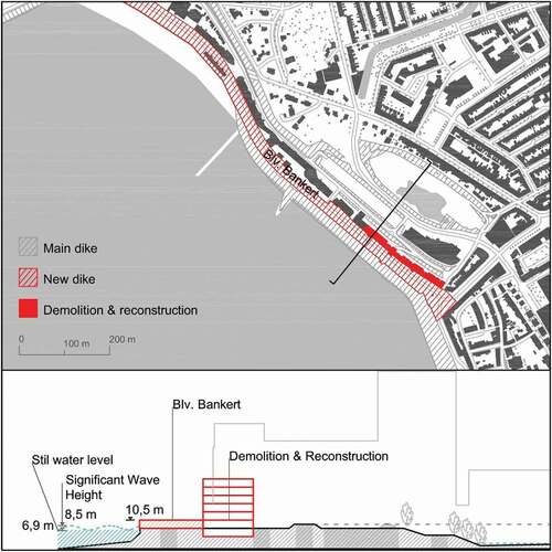
Results of the hydrodynamic modeling show that no or not significant overtopping will occur with +3 meters primary defense line. Consequently, the flood damage model results in no damage induced. Using the standard cost of heightening the dike (per meter) in the urban area of the Netherlands it was estimated that if the dike-in-boulevard with 2 kilometers length increasing 3 meters height would cost a present value of roughly more than 200 million euro (inflation rate of 5.5%) as initial investment, with a total maintenance cost more than 15 million from current year to the year of 2100 (Hillen et al. Citation2010)
3.3. The Spuikom Model
The Spuikom model hinged on the (re)activation of a former water reservoir – the Spuikom – once connected with the harbor and partially filled in the second half of the twentieth century to allow new urban developments. What remains of this water reservoir appears today as an open space, partially covered with spontaneous vegetation, partially inundated, and partially used as a car park. Located in a central area of the city, the Spuikom and its surroundings are now the object of a long-term vision by the municipality that aims to integrate flood defense measures with a new mixed-use urban development (with commercial, residential, and leisure functions). The inclusion of real estate development is part of the financial plan for this strategy. This strategy involves the re-routing of water runoff from the seafront boulevard towards the sump through the use of movable barriers to avoid the flood to reach other city areas. Moreover, it requires redesigning the currently low-quality area of the basin to attain a sufficient temporal storage capacity, and to be able to improve the landscape quality at the same time. The overtopped water will be buffered here and then discharged via the nearby canal that drains excess water over a longer period of time. The interventions include the excavation of the bottom of two available Spuikom areas (S1 and S2) to an average depth of +0 m and raising the edges to +4.96 m above NAP (the Normal Amsterdam Peil). Movable barriers of at least 2 m height are needed on the four roads/passages that give access to the area (). The “Watersgang” channel located North of the Spuikom is used to drain excess water by means of a weir.
Figure 4. Spatial design strategy: the Spuikom Model; plan and prototypical section (elaboration: A. Bortolotti).
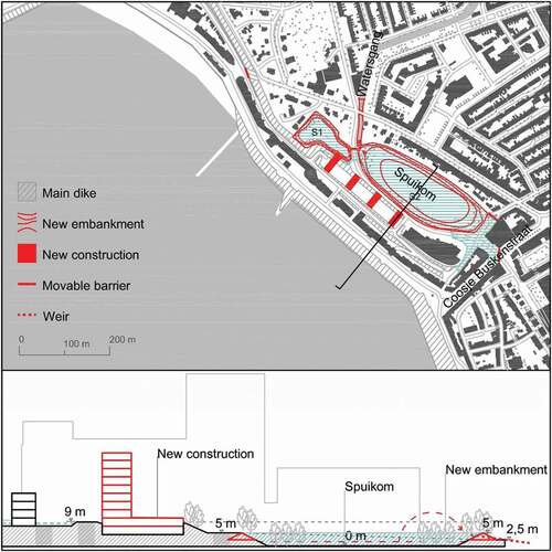
According to the hydrodynamic model, 275,000 m3 of excess water is estimated to flood the Spuikom at the peak of the storm. On the other hand, the recovery of additional storage capacity makes it possible to achieve a retention capacity for the Spuikom of 186,000 cubic meters (140,000 m3 on S2 and 46,000 m3 on the S1). The remainder (89,000 m3) must be managed by the Watersgang. With an outflow of 5 m3/s generated by a pump installed at the opposite end of the channel, the Watersgang can drain up to 18,000 m3 over the storm duration. The remaining 71,000 m3 can be stored in the channel itself, resulting in an increase in average water level of 0.41 m. The redesign of the Spuikom requires the excavation of around 15,400 m3 in S1 and of 18,800 cubic meters in S2. On the other hand, 8,500 m3 cubic meters of earth are needed to raise the embankments of S2 to a minimum height of 2.5 m where these are lower. In this case, the damage is limited and mostly concentrated in the buildings and roads behind the Boulevard (see details in Appendix), resulting in 8.6 million Euros damage and 42 affected inhabitants.
4. Discussion of the results: towards a preliminary cost-benefit analysis
It is commonly considered that a rigorous evaluation between planning choices is based on a cost-benefit analysis-the financial and social feasibility of the plan. Yet, the monetization of all the aspects touched by the framework turns out to be a complex, if not impossible, task. While damages can be estimated according to losses caused by a flood event (in physical terms and human lives), there is no easy estimation of urban interventions’ costs and benefits involved by the design strategies for area development. As recalled by Eijgenraam et al. (Citation2000), no codified method is available to measure the added value of sound design for urban regeneration projects. It is difficult to measure the impacts in terms of increased land value, urban quality, and attractiveness of an urban regeneration project.
For instance, one can estimate that raising the dike and the boulevard as foreseen in the Vlissings Model implies a massive use of sand and cement, resulting in high economic (and environmental) costs while disrupting the historical relationship between the urban front and the sea, including the demolition of historical buildings. Certainly, this would result in no damage costs to be allocated also in the case of an extreme flood event. On the other hand, the evaluation of the Spuikom Model which is an integrated urban regeneration program that includes the construction of new buildings and the setting of a controlled flooding area is more difficult to be nuanced. This fact highlights the difficulties in comparing the two strategies. When comparing infrastructure projects with urban development, only in the first it is possible to enforce a broader strategic vision on targeted and measurable interventions. Flood risk assessments are tailored at the small scale of a specific city or site to support decision-making in that area by evaluating the (cost-)effectiveness of different types of measures (de Moel et al. Citation2015). For urban area development, which is more complex, the CBA becomes more specific during the development of the project. But the design phase is done with a low data resolution, includes costs and benefits taken over a longer period of time, with the inclusion of more uncertainties. As a result, the CBA turns out to be a form of Multi-Criteria Analysis (MCA) which attempts to account for the main non-measurable effects of area development.
This difference between the ability to target costs and effects very detailed for infrastructure projects and “fuzzy” for urban development is an issue that often comes up in the debate about the choice between gray and ‘other,’ or nature-based infrastructures, that still lack regulatory recognition and insurance coverage.
Results of the analysis conducted using the D&A framework are presented in a matrix form which follows the triple structure of design strategy – hydrodynamic model – damage model, developed for the three strategies object of study (see ). The matrix facilitates the visual understanding of the implications of the three strategies, respectively, at the spatial, hydraulic, and damage level.
Figure 5. The results of the D&A framework - general overview: Maximum water depth map (a-c) and the corresponding total flood damage map (d-f) under extreme sea level at 1/10,000 p.Y in 2100 fora) Baseline strategy, b) Vilissings Model and c) Spuikom Model (elaboration: A.Bortolotti, A.Diaz,Q.Ke)
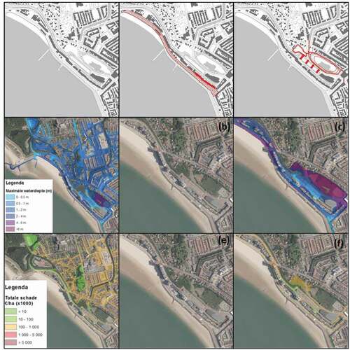
The quantitative analysis in shows the results of flood economic damage at 2011 price level and net present value (PV) for baseline, Vlissings Model and Spuikom Model under three different discount rates (with a median estimation of 5.5%). It shows that no economic damage will be caused under the Vlissings Model since all the water will be blocked away with a (extremely) high dike system. While the economic damage caused by the Spuikom Model is approximately 12–16 million euro at PV which is only 1/6 of damage under the Baseline strategy (~80–100 million euro).
The qualitative CBA for area development is presented in and shows the qualitative aggregated results of . The general definition of positive or negative outcomes is based on the overview of and in which the costs, benefits, and effects are listed for both strategies. The outcome is considered negative when the intervention does not create additional economic, social, and spatial values. For the quantitative translation of the estimated flood damage and loss of lives the perspective of flood risk takes the given return period of 1:10,000 years into account which results in the estimated annual damage (EAD) of ~ 5000 euro/year under baseline strategy, and 0 euro/year and ~300 euro/year under the Vlissings Model and the Spuikom Model, respectively. This means Vlissings Model and Spuikom Model can reduce the EAD with a benefit of ~5,000 euro/year and ~4,700 euro/year, respectively. The benefit value is more or less equivalent compared to the large investment on the modification of buildings and dikes (usually millions of euros on the initial cost and annual maintenance cost).
Table 2. The qualitative CBA for the Spuikom Model.
Table 3. Summary of flood economic damage, the number of total fatalities, and affected people, EDA and benefit for different strategies.
Table 4. The summary and comparative table of qualitative evaluation of each strategy.
The D&A framework was partially developed together with the municipality Vlissingen as part of the SARCC (Sustainable and Resilient Coastal Cities) research targeted at inclusion of nature-based solutions as part of the flood risk management strategy. It is clear that accepting water as nature in urban coastal areas urges for both fields, spatial planning and hydraulic engineering, a shift in approach. Spatial planning needs to integrate better the perspective and tools of hydraulic engineering. Hydraulic engineering needs to adapt to the fact that including natural components in infrastructure designs, flexibility, adaptability to changing environmental conditions and extra functionalities and ecosystem services can be achieved, often at lower costs on a life-cycle basis than “traditional” engineering solutions (De Vriend et al. Citation2015). This requires a different way of thinking, acting, and interacting which is reflected on by the discourse Building with Nature, which is another way of working to contextualize infrastructure projects that meet society’s needs for infrastructural functionality, and to create room for nature development at the same time (De Vriend et al. Citation2015).
Another interesting point of attention is that the municipality Vlissingen, on the basis of this work, started with the design and construction of the first “road as a river” concept for the main road that conveys water to the Spuikom. The municipality uses this pilot to change the paradigm of reducing probability. Being a small municipality, Vlissingen does not have the knowledge and capacity to develop the Spuikom strategy alone, so it partially used results from this study to be able to advance on the project autonomously with respect to the National Water State (RWS) and the Water Board, which normally provide this expertise to local government, but that in this case are not aligned with the project objectives (being the roads responsibility of the municipality). With this, another point is important. Dutch flood risk management is organized in dike rings, the societal commitment organized in water boards from the fourteenth century onwards. The assessment of flood protection is done per dike part, where it is also assessed which value is behind the dike and to which extent the dike needs to protect this, e.g. what is the protected value to validate the investment. The scalability of the Spuikom Model is therefore opportune, however there needs to be a regional plan of the flood risk which is not done for this pilot. In this example, the water coming over other dike parts of the Vlissingen waterfront is not taken into account.
5. Conclusions
The main goal of this study is to understand the design impacts of the paradigm shift in flood risk management from reducing probability of the flood event to reducing its consequences. The acceptance of the consequences is done by using NBS. This is applied in the city of Vlissingen, the Netherlands, by comparing two spatial adaptation strategies that are modeled and compared by using spatial and climatic projections for the year 2100. The two strategies are named “Vlissings Model,” which is holding the defence line and “Spuikom Model,” which is expanding flood risk management to an urban zone. The Vlissings Model is about increased coastal protection through the heightening of existing grey infrastructure which includes the dike and buildings constructed on top of it. The Spuikom Model is accepting and rerouting overtopping water towards an existing backshore water basin. The study brings forth an interdisciplinary “Design & Assess” framework that supports development of – and evaluates results of – these two design strategies. By evaluating the two strategies with the flood damage models and cost/benefit analyses, the impact of paradigm shift in dealing with extreme SLR is clear: it becomes more complex and fussier for decision makers but it can be better related to societal values.
The study resulted in two types of conclusions: on content and in process. Content wise it became clear that in the prevailing paradigm of flood defense the cost-benefit analysis is targeted and clear because of simplification of and focus on the problem. When aiming at reducing the size of the urban area that is exposed consequently reducing damage, this is done by engineering a thin line: the dike. This line not only represents the flood defense line but also the fact that when the project remains as small and simple as possible the cost benefit analysis is most optimum. To do the CBA there are tools and existing financial ratios already available to be able to get insight into the size of the project quite easily. This is not necessarily the “best” outcome within the evaluation of spatial quality.
Based on the results of CBA, Spuikom Model creates more societal value on a larger scale but is less risk and economically efficient than the Vlissings Model, which shows the conventional gray infrastructure measure.
The major difference when moving to the new paradigm of reduction of consequences is that this small controllable base literally opens up to a zone in which many more variables and stakeholders take part. The CBA becomes much more complex and introduces the qualitative evaluation that needs to be approved by a political decision on where the budget will be spent, and which benefits serve the society at best. Accepting that urban areas are exposed to a hazard in which costs and benefits of urban development, improvement of functionality and quality, are taken into the equation becomes “fuzzy” and difficult to predict.
The overview given in the discussion paragraph shows that the paradigm shift from reduction of the probability to the reduction of the consequences in flood risk management (in the case of Vlissingen) has a few major changes in current practice. To answer the main question driving this research: what does it mean practically when NBS become part of the flood risk management strategy, the findings are as follows. Inclusion of the reduction of exposure and vulnerability in urban flood management as a zone and inclusion of NBS makes the hydraulic engineering modeling a crucial aspect in the design process. The hydraulic model confirmed the technical feasibility of the design strategies for the temporary storage in the inland water system of the Spuikom and Watergang of overtopping water in the case of an extreme climate scenario at 2100. The combination of the hydrodynamic model with land-use maps allowed us to calculate flood damages. This way of working can support the qualitative CBS and give insight in societal benefits in the longer term. The CBA of flood risk management becomes literally part of the CBA for area development which means that longer term effects can become an integral part to support a paradigm shift in which the consequence reduction becomes part of the CBA as an effect.
Acknowledgment
TU Delft Departments of Urbanism and Hydraulic Engineering are accompanying this reflection investigating in detail the spatial and hydraulic issues that such a vision entails. This paper is the result of research funded by INterreg 2Seas SARCC project.
Disclosure statement
No potential conflict of interest was reported by the authors.
Funding
The work was supported by the Interreg 2 seas [2S06-050].
CRediT authorship contribution statement
F. Hooimeijer: Conceptualization, Investigation, Methodology, Writing - original draft, Writing - review & editing. A. Diaz: Conceptualization, Investigation, Data curation, Modeling, Writing - original draft. A. Bortolotti: Conceptualization, Investigation, Methodology, Visualization, Writing – original draft, Writing – review & editing. Q. Ke: Conceptualization, Investigation, Data curation, Modeling, Writing – original draft. J. van der Heuvel: Data curation, Modeling. J. Bricker: Conceptualization, Investigation, Methodology, Writing - review & editing.”
Notes
1. This tool can be accessed upon request at the website: www.helpdeskwater.nl/ssm2017.
References
- EurOtop .2018. Manual on Wave Overtopping of Sea Defences and Related Structures. An Overtopping Manual Largely Based on European Research, but for Worldwide Application. J.W. Van der Meer, N.W.H. Allsop, T. Bruce, J. De Rouck, A. Kortenhaus, T. Pullen, H. Schüttrumpf, P. Troch and B. Zanuttigh, www.overtopping-manual.com.
- Bricker, J D., S Gibson, H Takagi, and F Imamura. 2015. “On the Need for Larger Manning’s Roughness Coefficients in Depth-Integrated Tsunami Inundation Models.” Coastal Engineering Journal 57 (2): 1550005. doi:https://doi.org/10.1142/S0578563415500059.
- Bruijn, K, D de Wagenaar, K Slager, M de Bel, and A Burzel. 2015. “Updated and Improved Method for Flood Damage Assessment: SSM2015 (Version 2).”
- Bruijn, K de, D Wagenaar, K Slager, M de Bel, and A Burzel. 2015. ””Updated and Improved Method for Flood Damage Assessment: SSM2015”.” Deltares.
- CPB. 2017. “Cost – Benefits Analysis for Flood Risk Management and Water Governance in the Netherlands: An Overview of One Century, Centrale Plan Bereau.” Background Document.
- de Jong, TM., and D.J.M Van Der Voordt. 2002. Ways to Study and Research: Urban, Architectural, and Technical Design. Delft: DUP Science.
- de Moel, H, B Jongman, H Kreibich, B Merz, E Penning-Rowsell, and P J Ward. 2015. “”Flood Risk Assessments at Different Spatial Scales”.” Mitigation and Adaptation Strategies for Global Change 20 (6): 865–890. https://doi.org/https://doi.org/10.1007/s11027-015-9654-z
- De Vriend, HJ, M van Koningsveld, SG Aarninkhof, MB de Vries, and MJ Baptist. 2015. “Sustainable Hydraulic Engineering Through Building with Nature.” Journal of Hydro-Environment Research 9 (2): 159–171. doi:https://doi.org/10.1016/j.jher.2014.06.004.
- Deming, M E, and S Swaffield. 2011. Landscape Architectural Research: Inquiry, Strategy, Design. Hoboken, NJ: John Wiley & Sons.
- Department of the Prime Minister and Cabinet, O. of B. P. R. 2018. “Best Practice Regulation Guidance Note: Value of Statistical Life.” In Australian Government, https://pmc.gov.au/sites/default/files/publications/value-of-statistical-life-guidance-note.pdf
- Diaz Loaiza, M a, J D Bricker, R Meynadier, T M Duong, R Ranasinghe, and S N Jonkman. 2022. “Development of Damage Curves for Buildings Near La Rochelle During Storm Xynthia Based on Insurance Claims and Hydrodynamic Simulations.” Nat. Hazards Earth Syst. Sci 22: 345–360. https://doi.org/https://doi.org/10.5194/nhess-22-345-2022
- Dutton, H. 2000. “An Integral Approach to Structure and Architecture’, Perspecta 31 Reading Structures.” Yale Architectural Journal, Lnco-Operation 31: 60–69. https://doi.org/https://doi.org/10.2307/1567251
- ECORYS and Witteveen + Bos. 2009. Werkwijzer van Integrale Gebiedsontwikkeling. The Hague: VROM.
- Eijgenraam, CJJ, CC Koopmans, PJG Tang, and ACP Verste. 2000. Evaluatie van Infrastructuurprojecten. Leidraad Voor Kosten-Batenanalyse. The Hague: Centraal Planbureau and Nederlands Economisch Instituut.
- European Commission. Joint Research Centre. 2018. Climate Impacts in Europe: Final Report of the JRC PESETA III Project. Publications Office. https://data.europa.eu/doi/https://doi.org/10.2760/93257
- Gallien, T, N Kalligeris, M P Delisle, B X Tang, J Lucey, and W Winters. 2018. “Coastal Flood Modeling Challenges in Defended Urban Backshores.” Geosciences 8 (12): 450. https://doi.org/https://doi.org/10.3390/geosciences8120450
- Haasnoot, M, J H Kwakkel, E Warren, Walker C, and J Ter Maat. 2012. “Dynamic Adaptive Policy Pathways: A Method for Crafting Robust Decisions for a Deeply Uncertain World.” Global Environmental Change Journal 23 (2): 485–498. https://doi.org/https://doi.org/10.1016/j.gloenvcha.2012.12.006.
- Hillen, M, S N. Jonkman, W Kanning, M Kok, M A. Geldenhuys, & M J. F. Stive. 2010. Coastal Defence Cost Estimates:Case Study of the Netherlands, New Orleans and Vietnam (ISSN 0169-6548). Department of Hydraulic Engineering. Delft. The Netherlands: Delft University of Technology.
- Hultkrantz, L, and M Svensson. 2012. “The Value of a Statistical Life in Sweden: A Review of the Empirical Literature.” Health Policy 108 (2–3): 302–310. doi:https://doi.org/10.1016/j.healthpol.2012.09.007.
- Jonkman, B, and J K Vrijling. 2008. “Loss of Life Due to Floods.” Journal of Flood Risk Management. https://doi.org/https://doi.org/10.1111/j.1753-318X.2008.00006.x
- Kaźmierczak, A, and G Cavan. 2011. “Surface Water Flooding Risk to Urban Communities: Analysis of Vulnerability, Hazard and Exposure.” Landscape and Urban Planning 103 (2): 185–197. doi:https://doi.org/10.1016/j.landurbplan.2011.07.008.
- Kok, M, H J. Huizinga, A C. W. M. Vrouwenvelder, and W E. W. Van den Braak. 2005. “Standaardmethode 2005 Schade En Slachtoffers Als Gevolg van Overstromingen.”
- Kron, W. 2005. “Flood Risk = Hazard • Values • Vulnerability.” Water International 30 (1): 58–68. doi:https://doi.org/10.1080/02508060508691837.
- Merz, B, J Hall, M Disse, and A Schumann. 2010. “Fluvial Flood Risk Management in a Changing World.” Natural Hazards and Earth System Sciences 10 (3): 509–527. doi:https://doi.org/10.5194/nhess-10-509-2010.
- Mietzner, D, and G Reger. 2005. “”Advantages and Disadvantages of Scenario Approaches for Strategic Foresight”.” International Journal of Technology Intelligence and Planning 1 (2): 220–239.
- Oppenheimer, M, BC. Glavovic, J Hinkel, R van de Wal, AK. Magnan, A Abd-Elgawad, and R Cai, et al. 2019. “Sea Level Rise and Implications for Low-Lying Islands, Coasts and Communities.” In IPCC Special Report on the Ocean and Cryosphere in a Changing Climate (Intergovernmental Panel on Climate Change), edited by H.-O. Pörtner, D.C. Roberts, V. Masson-Delmotte, P. Zhai, M. Tignor, E. Poloczanska, K. Mintenbeck, A. Alegría, M. Nicolai, A. Okem, J. Petzold, B. Rama, N.M. Weyer.
- Peduzzi, P, H Dao, C Herold, and F Mouton. 2009. “Assessing Global Exposure and Vulnerability Towards Natural Hazards: The Disaster Risk Index.” Natural Hazards and Earth System Sciences 9 (4): 1149–1159. doi:https://doi.org/10.5194/nhess-9-1149-2009.
- Priemus, H. 7 August 2011. “Vooraf de Juiste Maatschappelijke Afwegingen Maken.” B&G. 22–26.
- Ramirez, J a, M Lichter, T J Coulthard, and C Skinner. 2016. ”Hyper-Resolution Mapping of Regional Storm Surge and Tide Flooding: Comparison of Static and Dynamic Models”. Natural Hazards 82 (1): 571–590. https://doi.org/https://doi.org/10.1007/s11069-016-2198-z
- Rijkoverheid. 2020. “Schade En Slachtoffer Module [Online].” https://www.helpdeskwater.nl/onderwerpen/applicaties-modellen/applicaties-per/aanleg-onderhoud/aanleg-onderhoud/schade-slachtoffer/
- Romijn, G, and G Renes. 2015. “General Guidance for Cost-Benefit Analysis.” The Hague: PBL, https://www.pbl.nl/en/publications/general-guidance-for-cost-benefit-analysis
- Slager, K, and D Wagenaar. 2017. “Standaardmethode 2017: Schade En Slachtoffers Als Gevolg van Overstromingen.”
- Stronkhorst, J, O Lagendijk, J Kind (Deltares), M Wienhoven, M Briene (Ecorys), A Loes Nillesen (Defacto), and M Loffler (Bureau Landwijzer). 2012. “Toekomstbestendige Verharde Zeeweringen; Mogelijke Inrichtingsconcepten, Ontwikkelpaden En Strategieën, Deltares.”
- Vellinga, P, C Katsman, A Sterl, J Beersma, W Hazeleger, J Church, R Kopp, et al. 2009. “Exploring High-End Climate Change Scenarios for Flood Protection of the Netherlands, KNMI Scientific Reports.” https://edepot.wur.nl/191831
- Vlissingen, and An Ma. 2010. Structuurvisie vlissingen Stad Aan Zee - Een Zee Aan Ruimte.Vlissingen.
- Vousdoukas, M I, E Voukouvalas, L Mentaschi, F Dottori, A Giardino, Bd Bouziotas, A Bianchi, P Salamon, and L Feyen. 2016. ”Developments in Large-Scale Coastal Flood Hazard Mapping”. Natural Hazards and Earth System Sciences 16 (8): 1841–1853. https://doi.org/https://doi.org/10.5194/nhess-16-1841-2016
- Vries, J, and M de & Wolsink, 2009. Making Space for Water: Spatial Planning and Water Management in the Netherlands. In S. Davoudi, J. Crawford, A. Mehmood (edited by) Planning for Climate Change: Strategies for Mitigation and Adaptation for Spatial Planners, London: Earthscan 14: 191–204.