
Abstract
The relationship between climate change, environmental change and migration in mountain areas is a relatively understudied research topic, particularly from an empirical point of view. This article aims at contributing to the literature by analysing the relationship between increasing rainfall variability, livelihoods and human mobility in three rural communities located in the Central Highlands of Peru. Traditional rain-fed agriculture is the most important economic activity in the area. This article highlights differences in livelihood and human mobility patterns between households located at different altitudes. While at higher altitudes (above 3900 m.a.s.l.) non-agricultural diversification is limited, at lower altitudes (up to 3600 m.a.s.l.) non-agricultural diversification is widespread and income from non-agricultural activities exceeds agricultural income. In this rural–urban context, rainfall patterns influence local livelihoods and migration decisions through their effect on agricultural production. More than four-fifths of the population noted changes in rainfall patterns and their negative effect on livelihoods. However, mobility patterns in the area are determined primarily by broader economic considerations. In the lowlands, one or more members of most households commute daily to work in the city of Huancayo. In the highlands, households (or some of its members) often resettle there. In both cases, circular migration patterns (including daily mobility) can be identified and households combine the scarce income from agricultural production with urban income rather than abandoning the farming land.
Introduction
The work of the Intergovernmental Panel on Climate Change (IPCC) reflects a wide consensus that human activity is influencing the climate, and that changes in the climate will influence population distribution in the coming decades (IPCC, Citation2007).
In this context, geographers, migration and legal scholars, economists, environmental and social scientists are studying the relationship between climate change, environmental change and human mobility. Researchers are often taking an interdisciplinary approach in order to bridge concepts and goals (Warner, Citation2011).
In spite of the specificities of mountain areas such as inaccessibility, fragility, marginalization of communities and high sensitivity to climate change, very few studies focus on the interaction between climate change, environmental change and human mobility in such areas (Kollmair & Banerjee, Citation2011). This article aims at addressing this gap by contributing data and insights from fieldwork conducted for the Peruvian case study of the ‘Where the Rain Falls’ (Rainfalls) project.
The two following sections of this article introduce the research site and the methods applied to gather quantitative and qualitative data. Afterwards, the results will be presented in two sections: the first one focuses on perceived and actual changes in recent rainfall patterns and their effects while the other presents livelihood and migration patterns at different altitudes. Whenever relevant, households located on highland/higher altitude (above 3900 m.a.s.l.) will be distinguished from those located on lowland/lower altitude (between 3200 and 3600 m.a.s.l.). Finally, the discussion will connect the results of the two preceding sections and the conclusion will analyse some of the implications of this article.
The research site
Province of Huancayo
The province of Huancayo belongs to the region of Junín and it is inhabited by 497,299 people. Most of its land (57%) is natural grazing land while 30% is used for non-agricultural purposes and 10% is plough land.
The gross domestic product of the Huancayo province has been growing at 0.5% per year between 1993 and 2007; nowadays, 6.4% of the population lives in extreme poverty and 22% in relative poverty (Instituto Nacional de Estadística e Informática [INEI], 2010a, p. 82). The unemployment rate is 4.8% and it is slightly higher for men than for women (5.0% versus 4.4%). The agricultural economic sector employs 14.5% of the population.
Only 12% of the population of the province lives in rural areas. This percentage has been decreasing since 1940; in particular, between 1993 and 2007, the urban population has increased at an annual rate of 1.3% while the rural population has decreased by 3.8% per year. There is a marked difference between illiteracy rates in rural (14.9%) and urban (4.7%) areas (INEI, Citation2010b).
Patterns of human mobility
Most studies on livelihood and migration patterns in the Central Highlands of Peru until the 1980s focused on the effect of the development of the mining sector on local livelihoods from the early twentieth century.
Mallon conducted a very comprehensive study of the evolution of rural communities in the Peruvian Central Highlands from 1780 (and particularly from 1860) to 1940. Her book shows that migration, particularly seasonal migration, has always been a common livelihood diversification and risk management strategy in the area (Mallon, Citation1983).
Long and Roberts (Citation1978, Citation1984) studied the complexity of the rural society in Mantaro Valley between the late nineteenth century and the 1970s. Rural livelihoods were characterized by complex inter- and intra-household social and economic interconnections (Long & Roberts, Citation1984). The peasant economy could not be distinguished from the capitalist economy (Long & Roberts, Citation1984, p. 109). Migration was ‘not from a peasant economy to a capitalist one, but … part of capitalist development’ (Long & Roberts, Citation1984, p. 138).
Migration in the 1980s and 1990s was mainly driven by the government's conflict with the terrorist group Sendero Luminoso and intermediate cities such as Huancayo received tens of thousands of migrants from the highlands. However, Huancayo also suffered from terrorist attacks which triggered migration to Lima (Haller & Borsdorf, 2013, p. 557).
Nowadays, the most common form of mobility for rural households in the Shullcas sub-basin is daily mobility (from lower altitude) and circular migration (from higher altitude) to the city of Huancayo.
Patterns of human mobility in rural areas of the province of Huancayo are determined primarily by the economic situation in the communities of origin of potential migrants as well as in the city of Huancayo. Moreover, employment opportunities in other areas of Peru and abroad influence longer-term migration patterns (INEI, Citation2009).
Accordingly, survey data from this case study show that the three most important reasons determining migration decisions in the research site are economic: better job opportunities in the city; not enough income in the community of origin and unemployment in the community of origin (in descending order).
In the period between 2002 and 2007, the province of Huancayo had a negative internal migration rate of -11.4/1000 inhabitants. More than half of the internal migrants leaving it went to Lima (INEI, Citation2009). This percentage is lower in the research site: only 37% of the internal migrants from the lowlands and 26% from the highlands went to the capital.
With respect to international migration, 10.7% of urban households and 5.6% of rural households have one or more members living abroad. Among them, 68.1% have one/two members abroad, 19.7% have three/four members abroad and the remaining 12.2% have five or more (INEI, Citation2010b).
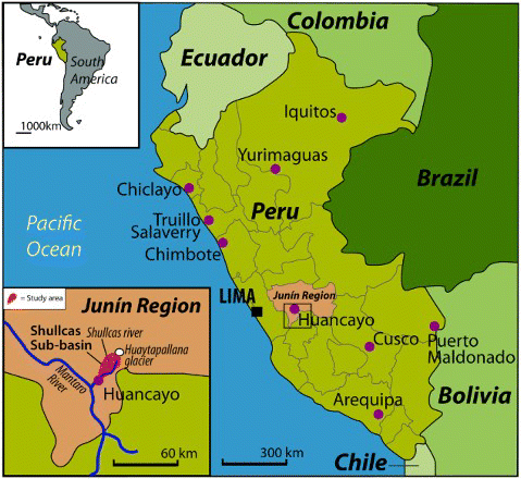
No provincial data on the preferred month of departure of migrants are available. Survey data from this case study show that more than 70% of the migrants from households located both on lower and higher altitudes on the Shullcas sub-basin leave during the wettest months of the year (January, February and March). These months are characterized by the high demand for agricultural workers in the Peruvian ‘ceja de selva’ (the outer edge of the Peruvian jungle – above 800 m.a.s.l.) ().
Figure 1. Location of the research site (map prepared by Milan & Rossow).
Shullcas sub-basin
The case study was conducted in the Shullcas River sub-basin and its surroundings.Footnote1 The sub-basin covers an area of 180.987 km2 in the Huancayo Province, 300 km east of Lima (Comisión Nacional del Ambient [CONAM], 2005b, p. 16). The Shullcas River runs for 35.9 km from the Chuspicocha and Huntay Lazo lagoons (which receive water from the Huaytapallana glacier range) to the east side of the city of Huancayo, whose main source of water supply is the river itself. The area is situated in the central part of the Mantaro basin.
Fieldwork took place in October and November 2011 in three communities of the sub-basin, two of them belonging to the Huancayo district and the last one to the El Tambo district:
Acopalca, located on the highland of the Shullcas River sub-basin at 3900 m.a.s.l. and populated by 162 households.
Chamisería (administratively part of the Acopalca community), situated on the lowland of the same sub-basin at 3583 m.a.s.l. and inhabited by 40 households.
Paccha, located on the lowland (at 3260 m.a.s.l.) in the Hullahoyo sub-basin (on the border of the Shullcas sub-basin) which consists of 300 households.
Traditional rain-fed agriculture is the most important economic activity in the area. At higher altitudes (above 3900 m.a.s.l.) non-agricultural diversification is limited whereas at lower altitudes (up to 3600 m.a.s.l.) non-agricultural diversification is widespread and income from non-agricultural activities exceeds agricultural income.
In the highlands, climatic conditions only allow households to produce potatoes (100% of households using land for agricultural purposes), often in combination with one or more other Andean tubers (mashua, oca and olluco). In the lowlands, potatoes are still the most common crop but households also grow corn (77% of household using land for agricultural purposes) and lima beans (27% of them). Embroidery/handicraft is the most common second main economic activity
Research methods
Data were gathered through a multi-method approach, combining 150 household surveys, 14 expert interviews and 23 participatory research approaches (PRA) sessions involving almost 150 people.
For the survey analysis of differences between lowland and highland, the authors identified 71 households based in the lowlands and 43 based in the highlands. Thirty-three households from Paccha were excluded from the analysis because they were either based on both floors or it was not possible to determine where they were located.
For a detailed description of the methodologies, please refer to the research protocol of the ‘Where the Rain Falls’ (Rainfalls) project (Rademacher-Schulz et al., 2012). For more data, information on sampling, site selection and limitations in the case of Peru, please refer to the Rainfalls Peru case study report (Ho & Milan, 2012).
Recent changes in rainfall: perception versus rainfall data
The meteorological station nearest to the three research communities (Shullcas) is located in the Shullcas sub-basin (El Tambo district and province of Huancayo) at 3750 m.a.s.l., between what is defined in this article as lowland (up to 3600 m.a.s.l.) and highland (above 3900 m.a.s.l.).
Daily precipitation data are only available since October 1997 hence this article focuses on the great variability in rainfall between 2009 and 2011 with respect to the preceding 11 years rather than on long-term trends.
The average annual rainfall in Shullcas from 1998/99 to 2010/2011 (875 mm/year) is higher than in the other meteorological stations located in the lowlands in Mantaro Valley (see Instituto Geofísico del Peru [IGP], 2012, p. 55). The decreasing trend in annual rainfall until 2008/2009 is in line with the data from the Huayao Station, located in the lowlands in Mantaro Valley (Silva, Trasmonte, & Giráldez, Citation2007) ().
Figure 2. Total rainfall and number of rainy days per year from the Shullcas meteorological station. Rain years are calculated from July to the following June.
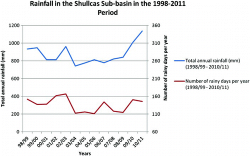
The Mantaro river basin is characterized by unpredictability of rainfall (IGP, Citation2010, p. 32). Survey data for this case study show that 85% of respondents observed changes in rainfall over the last 10–20 years. The two most perceived changes in rainfall were more rain in unexpected moments and longer dry spells.
More rain in ‘unexpected’ moments cannot be checked against rainfall data. However, it is worth noting that fieldwork was conducted right after the wettest August and September of the whole sample, with more than 70 mm of rain per month (the 1998–2011 average for these months is 21.8 and 39.5, respectively). Regarding the perception on duration of dry spells, data from the Shullcas meteorological station do not seem to show a clear trend.Footnote2
During the PRA sessions, the participants noted that the previous 2 years (2009–10 and 2010–11) had been characterized by heavy rains and great variability in rainfall patterns. This perception seems to match the rainfall data: these rain years were characterized by a very high amount of total annual rainfall (third highest and highest in the 1998–2011 period, respectively) but they also show sharp differences in rainfall patterns ().
Figure 3. Average monthly rainfall of the 2009/10 and 2010/11 seasons versus long term average from the Shullcas meteorological station.
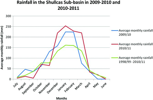
In fact, almost two-thirds of annual rainfall in 2010–11 was concentrated in 3 months, which were also the three wettest months of the whole sample. On the contrary, in 2009–2010, all months from July to February (except October) had higher than average rainfall.
The last 2 years were also characterized by great differences in rainfall patterns during the first months of the rainy season. In the 2009–2010 season, August and September were very wet while 2010–11 had the latest onset of the entire 1998–2011 period. In contrast with the previous year, 2011–2012 showed the earliest onset of the whole period.Footnote3
Effects of changing rainfall
As mentioned above, changes in rainfall over the last 10–20 years were observed by 85% of survey respondents. They were asked whether changing rainfall affected their food production: a slight majority (53%) of respondents replied ‘yes, a lot’, 41% said ‘yes but only a little’ while 5% replied ‘no’ (and 2% did not reply).
However, these results are quite different depending on the altitude: 35% of respondents in the highlands said ‘yes, a lot’ and 61% said ‘yes but only a little’ while in lowlands the percentages are 62% and 30%, respectively. A possible explanation for this difference is that at lower altitudes rain-fed agriculture is the most common main economic activity while at higher altitudes cattle herding prevails over agriculture.
Livelihood and migration patterns at different altitudes
Two types of livelihoods can be identified in the research site: Acopalca and the upper part of Paccha (called Suytucancha) are located at a relatively higher altitude (above 3900 m.a.s.l.) while Paccha (lower part) and Chamisería are located at relatively lower altitude (between 3200 and 3600 m.a.s.l.). presents the main differences between the two.
Table 1. Livelihood and mobility patterns by altitude – percentages refer to answers to the household survey.
Local experts estimate that there has been a 50% increase in the urban area of Huancayo in the last 20–30 years. In the same period, means of communications between Huancayo and the surrounding communities have improved substantially. As a consequence, rural communities in the research site (particularly in the lowlands) are becoming increasingly connected to the city.
Most households located in the lowlands have one or more members that commute daily, either on a constant or on an occasional basis, to the city of Huancayo. Households from the highland do not enjoy the same ease of daily access to the city, both because of the greater distance from Huancayo and their isolation and more scattered geographical distribution.
People commuting daily to Huancayo often combine rural and urban life rather than abandoning their farming activities in the communities of origin. Even those who settle in the city (usually households from the highland) keep their agricultural plots for rain-fed agriculture and cattle herding (or both). They rely on members of their extended family to maintain farming work while they are away, at least in the first few years following their move.
At lower altitudes, the most common destination for temporal migration is Lima (37% of migrants) where many young people go to seek new horizons. A lower percentage of migrants go abroad, mostly to the United States while fewer people have migrated to Chile, Argentina, Uruguay and Italy. Seasonal migration (30% of migrants) is typically towards the Peruvian ‘ceja de selva’ (the outer edge of the Peruvian jungle – above 800 m.a.s.l.) to work on the coffee harvest (between February and August) as well as to take other rural work opportunities, particularly between January and March.Footnote4
At a higher altitude, about one fifth of the community members from Acopalca have migrated at least once to the United States to work as shepherds under contracts that generally last for three years. At the end of this period, most of them return to the community while a few of them stay for three additional years. It is not common for people to settle in the United States because working conditions there are perceived to be very hard. A similar percentage of migrants move to Lima (26% of migrants) while few women go to Argentina. Seasonal migration from the highlands is not common (less than one-tenth of migrants).
PRA participants from the lowlands highlighted several consequences of land fragmentation which they attributed to land division among descendants when they inherit it from their parents. In particular, they asserted that it hinders asset accumulation for young households and it boosts mobility to Huancayo as well as seasonal migration to the Peruvian jungle, usually by the head of the household.
In the highlands, cattle pastures are usually not inheritable because they revert to the community that holds them. The size of the pastures depends on the number of members of the farmers’ community (comunidad campesina) who share the communal land.
Differences in altitude and levels of access to urban opportunities can influence the geographical distribution of household members. Household members from the lowlands tend to live together, with one or more of them commuting to Huancayo daily. In the highlands, it is common to have one or more members of the household taking care of the animals in the communal land in the highlands while the rest of the household stays in Huancayo and takes urban economic and educational opportunities. The PRA participants noted that it is usually the household head (man) who stays in the highlands. In some cases (particularly in households with babies or children below school age) livestock care is left to the wife while the husband and the rest of the family migrates for short periods or seasonally to access employment and educational opportunities.
Discussion
In spite of the work opportunities in the urban area of Huancayo, this article shows that households from Paccha, Chamiserìa and Acopalca combine rural and urban activities rather than leaving their communities. This result is in line with the existing literature on migration in the area: already in the 1980s, research was showing the interconnections between the cities of Lima and Huancayo and the rural villages of Mantaro Valley as well as the combination of rural and urban activities in the area (Laite, Citation1981; Smith, Citation1984).
As a consequence of the combination of rural and urban activities that characterized the area, rainfall variability and climatic conditions in general still play an important role in shaping local livelihoods and they influence migration decisions which are primarily driven by broader economic considerations.
This article highlights that households located at lower altitudes have different migratory habits with relation to those in the highlands. In addition, they are more affected by rainfall variability, possibly because agriculture is the most common main economic activity in the lowlands while at higher altitudes cattle herding prevails over agriculture.
In the words of Laite (Citation1981, p. 120), in the first eighty years of the twentieth century, migration was not ‘a flight from the land by the landless but rather a means of maintaining work alternatives across a number of economic sectors’. This case study shows that daily mobility is now the most common means of maintaining work alternatives across a number of economic sectors for households based in the lowlands. The urban area of Huancayo can be accessed by commuting daily from the surrounding communities such as Paccha and Chamiserìa. Households based in the highlands maintain these alternatives through circular migration and they do not abandon their agricultural land.
It is always difficult for researchers dealing with climate change and migration to generalize the empirical results obtained at the local level. The results of the Rainfalls case study conducted in the Shullcas sub-basin are not an exception and they can neither be generalized for Peru nor for other mountainous areas worldwide.
However, this paper highlights the importance of altitude and ease of access to urban economic opportunities in shaping livelihoods and mobility patterns from mountain areas. These factors should be taken into account for future research on migration patterns and their development outcomes in other mountainous areas worldwide.
Conclusion
Different levels of access to centres of economic wealth and political power, high sensitivity to climate change, fragility, marginality and high climatic variability within short horizontal distances often characterize mountainous areas. These factors proved to be very important in explaining the effects of rainfall variability as well as livelihood and mobility patterns on the research site.
While this case study was conducted in a rural–urban context, the effects of climate change tend to be more severe in rural areas where people rely on rain-fed agriculture for their livelihoods (Gentle & Maraseni, Citation2012; Milan & Ruano, Citation2013). Future empirical studies on rainfall variability, livelihoods and migration in mountainous areas characterized by subsistence rain-fed agriculture would enhance understanding of the relationship between rainfall variability, food and livelihood security and migration.
An earlier study on migration from rural mountain communities to the city of Huancayo concluded that migration dynamics and outcomes were influenced by altitude and livelihood characteristics of the community of origin of migrants (de la Cadena, 1988). On the one hand, rural households from the lowlands were able to generate agricultural surpluses which allowed them to invest in Huancayo and successfully integrate in a relatively short time. On the other hand, poorer migrants from the highlands migrated in order to supplement their scarce agricultural income with urban work. Agricultural income remained important for them, given the scarcity and insecurity of urban income (de la Cadena, 1988).
In the light of this article, and 25 years after the publication of de la Cadena's study, it would be interesting for future research on migration patterns and outcomes in the Central Highlands of Peru to study how altitude and level of access to urban opportunities influence livelihoods both in the rural communities of origin and in the city of Huancayo.
Acknowledgements
We are deeply indebted to Dr. Koko Warner (UNU-EHS), Scientific Director of the ‘Where the Rain Falls’ (Rainfalls) project; Dr. Tamer Afifi (UNU-EHS) Rainfalls Research Director; Mr. Kevin Henry (CARE France), Rainfalls Project Coordinator and Ms. Aurélie Ceinos (CARE France), Rainfalls Project Officer. We would also like to express our gratitude to the Lima and Huancayo offices of CARE Peru and their research team. We are grateful to Ms. Verena Rossow (UNU-EHS) for the map as well as to Ms. Hana Sherin Galal (UNU-EHS) for the literature review and graphs. Last but not the least, we would like to thank the AXA Group and the John D. and Catherine T. MacArthur Foundation for generous funding of the research.
Notes
1. Two communities, Acopalca and Chamisería, are located in the Shullcas sub-basin. The other community, Paccha, is located in the Hullahoyo sub-basin which is at the border of the Shullcas sub-basin. Both sub-basins are located in the central part of the Mantaro basin and they are originated in the Huaytapallana glacier.
2. Dry spells (mentioned by 43% of survey respondents as longer and by 17% as more at unexpected moments) were defined as 7 or more days with less than 0.3 mm of average daily rainfall, in the period between 1 January and the 31 March (IGP, Citation2012, p. 206).
3. The onset was defined by the days in which annual precipitation reached 50 and 100 mm (CONAM, Citation2005a, p. 43).
4. The following definitions of migration were used: [Temporal] migration can be defined as a move from the household of origin during at least six months per year to a place within the country or abroad with the purpose of working, studying or family reunification, over a distance that forces the concerned person to settle at the destination to spend the nights. … Seasonal migration can be defined as yearly recurring migration over periods less than six months a year (de Haas, 2003, p. 414).
Related Research Data
References
- de la Cadena, M. (1988). Comuneros de Huancayo: Migración campesina en ciudades serranas (Documento de trabajo Nro. 26). Lima, Peru: Instituto de Estudios Peruanos (IEP).
- Comisión Nacional del Ambiente (CONAM) (2005a). Vulnerabilidad Actual y Futura ante el Cambio Climático y Medidas de Adaptación en la Cuenca del Río Mantaro (Vol. III), Lima, Peru: Comisión Nacional del Ambiente (CONAM) and Instituto Geofísico del Perú (IGP).
- Comisión Nacional del Ambiente (CONAM) (2005b). Diagnóstico de la cuenca del río Mantaro, bajo la visión del cambio climático (Vol. II), Lima, Peru: Comisión Nacional del Ambiente (CONAM) and Instituto Geofísico del Perú (IGP).
- Gentle, P., & Maraseni, T. N. (2012). Climate change, poverty and livelihoods: Adaptation practices by rural mountain communities in Nepal. Environmental Science & Policy, 21, 24–34. Retrieved from http://www.sciencedirect.com/science/article/pii/S1462901112000445 doi: 10.1016/j.envsci.2012.03.007
- de Haas, H. (2003). Migration and development in southern Morocco: The disparate socio-economic impacts of out-migration on the Todgha Oasis valley (PhD thesis). University of Nijmegen.
- Haller, A., & Borsdorf, A. (2013). Huancayo metropolitano. Cities, 31, 553–562.
- Ho, R., & Milan, A. (2012). Where the Rain Falls (Project Case Study Report Peru. Report no. 5). Bonn: United Nations University Institute for Environment and Human Security (UNU-EHS).
- Instituto Geofísico del Perú (IGP) (2010). Cambio climático en la cuenca del Mantaro. Balance de 7 años de estudios, Lima, Peru: Instituto Geofísico del Perú.
- Instituto Geofísico del Perú (IGP) (2012). Eventos meteorológicos extremos (sequías, heladas y lluvias intensas) en el valle del Mantaro, Lima, Peru: Instituto Geofísico del Perú.
- Instituto Nacional de Estadística e Informática (INEI) (2009). Perú: Migraciones Internas 1993–2007, Lima: Instituto Nacional de Estadística e Informática.
- Instituto Nacional de Estadística e Informática (INEI) (2010a). Mapa de Pobreza Provincial y Distrital 2009. El enfoque de la pobreza monetaria, Lima: Instituto Nacional de Estadística e Informática.
- Instituto Nacional de Estadística e Informática (INEI) (2010b). Censos Nacionales 2007: XI de Población y VI de Vivienda – Perfil Sociodemográfico de la Provincia de Huancayo, Lima: Instituto Nacional de Estadística e Informática.
- IPCC (2007). Climate change 2007: Impacts, adaptation and vulnerability. In M.L. Parry, O.F. Canziani, J.P. Palutikof, P.J. van der Linden, and C.E. Hanson (Eds.), Contribution of working group II to the fourth assessment report of the intergovernmental panel on climate change (976 pp.). Cambridge, UK: Cambridge University Press.
- Kollmair, M., & Banerjee, S. (2011). Drivers of migration in mountainous regions of the developing world: A review. (Foresight: Migration and global environmental change driver review 9), London, UK: Government Office for Science.
- Laite, J. (1981). Industrial development and migrant labour, Manchester: Manchester University Press.
- Long, N., & Roberts, B. (Eds.). (1978). Peasant cooperation and capitalist expansion in Central Peru, Austin: University of Texas Press.
- Long, N., & Roberts, B. (Eds.). (1984). Miners, peasants and entrepreneurs: Regional development in the Central Highlands of Peru, Cambridge: Cambridge University Press.
- Mallon, F. A. (1983). The defense of community in Peru's Central Highlands: Peasant struggle and capitalist transition, 1860–1940, Princeton: Princeton University Press.
- Milan, A., & Ruano, S. (2013). Rainfall variability, food insecurity and migration in Cabricán, Guatemala. Climate and Development. Under review.
- Rademacher-Schulz, C., Afifi, T., Warner, K., Rosenfeld, T., Milan, A., Etzold, B., & Sakdapolrak, P. (2012). Rainfall variability, food security and human mobility: An approach for generating empirical evidence (Intersections No. 10). Bonn: United Nations University Institute for Environment and Human Security (UNU-EHS).
- Silva, Y., Trasmonte, G., & Giráldez, L. (2007). Variabilidad de las precipitaciones en el valle del Mantaro Memoria del sub proyecto. In Y. Silva (Ed.), ‘Pronóstico estacional de lluvias y temperature del aire en la Cuenca del rio Mantaro para su aplicación en la agricultura’ (2007–2010), (pp. 54–58). Lima, Perú: Instituto Geofísico del Perú (IGP).
- Smith, G. A. (1984). Confederations of households: Extended domestic enterprises in city and country. In N. Long, & B. Roberts (Eds.), Miners, peasants and entrepreneurs: regional development in the central highlands of peru, (pp. 217–234). Cambridge: Cambridge University Press.
- Warner, K. (2011). Interdisciplinary approaches to researching environmental change and migration: Methodological considerations and field experiences from the EACH-FOR project. In C. Vargas-Silva (Ed.), Handbook of research methods in migration, (pp. 366–395). Oxford, UK: Edward Elgar Publishing.