
Abstract
This article addresses the interrelation between rainfall variability, food insecurity and human mobility in three villages located in the Same District, Kilimanjaro, Tanzania, namely the villages Vudee, Bangalala and Ruvu Mferejini which are of distinct elevation and precipitation levels. It runs a comparison between the three villages and shows that there is a positive relationship between rainfall shortage and out-migration, after taking other important demographic and socio-economic factors into account, such as age, wealth and education. The article further argues that the mechanism through which rainfall variability affects human mobility in the research site is food insecurity for humans and livestock.
1. Introduction
Climate variability refers to a deviation from the long-term meteorological average over a certain period of time. Most simulations predict exacerbated variability and increasing extreme weather events as a result of global warming (IPCC, 2001). Droughts or floods are examples of extreme weather events categorized under climate variability. Generally, such events are characterized by their severe effects on people's livelihoods, especially on agricultural production and associated food security. Food security ‘exists when all people, at all times, have physical, social and economic access to sufficient, safe and nutritious food which meets their dietary needs and food preferences for an active and healthy life’ (FAO, Citation2002b).
Since the 1980s, several studies have been linking climatic and environmental changes to human migration. It is difficult to find an environmental migrant per se, as there are various economic, political, social and cultural push and pull factors that influence the migration decision alongside environmental issues (see, for example, Afifi & Jäger, Citation2010; Warner, Erhart, de Sherbinin, Adamo, & Onn, Citation2009).
Previous studies attempted to assess the effect of climate change and environmental problems on human migration. Empirical research has been conducted within the Environmental Change and Forced Migration Scenarios (EACH-FOR) project (Jäger, Frühmann, Günberger, & Vag, 2009) and a UNHCR Horn of Africa study (Afifi, Govil, Sakdapolrak, & Warner, 2012). These studies contributed to the literature with broad knowledge about the effect of climatic/environmental problems on human mobility. The Foresight Report (2011) is a meta-study that combines the literature and the existing empirical work on the topic in one document.
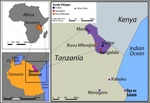
This article, however, addresses the interrelation between a specific climatic factor, namely rainfall variability, on one hand, and food insecurity and human mobility, on the other. The research is applied on three villages in the Same District, Kilimanjaro, located in north-east Tanzania (see ), on the borders with Kenya.
Tanzania's long-term economic growth is dependent on natural resources. Agriculture makes up more than half of the gross domestic product and employs about 80% of its labour force (Tanzania Invest, 2012). About 95% of the agricultural sector is rain-fed and subsistence based (HBS, 2007). Therefore, the effect that climate variability has on predominantly rain-fed agrarian economies might clearly be demonstrated by Tanzania (Van Aalst, Hellmuth, & Ponzi, 2007). The majority of rural households suffer from either chronic or transitory food insecurity. The National Environmental Policy (NEP, 1997) identifies deforestation and land degradation as the second and third most urgent problems out of six that require attention, respectively.
The main research objective of this article is to identify the circumstances under which households in the villages Bangalala, Ruvu Mferejini and Vudee use migration as a risk management strategy in response to rainfall variability and associated food insecurity. To do so, the following questions are addressed:
To what extent are the households of the study affected by rainfall variability?
What are the top environmental, social, economic and other factors that influence migration in the three villages?
What role does the rainfall in association with elevation in the three villages of research play in out-migration?
The article argues that rainfall variability affects human mobility, and highlights that the link between both variables is represented in food insecurity for humans and their livestock. It runs a comparison between the three villages with distinct elevations and associated rainfall differences, and shows that there is a positive relationship between rain shortage and out-migration, taking other socio-economic factors into account.
The article introduces the research site and its characteristics; analyses the observations made in the field on the main three variables (rainfall variability, livelihood/food insecurity and migration); and concludes and provides some policy recommendations. It is important to mention the research limitations briefly, for these to be considered/avoided in future research. The main challenges were the lack of follow-up with the same communities over a particular period of time, interviewing communities in the areas of origin rather than destination, the short time of field research (4 weeks), the small geographical coverage and the incomprehensiveness of meteorological data (Liwenga, Kwezi, & Afifi, 2012).
2. Research methods
The study involves a mixed-method approach which combines expert interviews (government officials, Environmental and migration scholars, meteorological specialists and NGO representatives), a household survey of 165 households (stratified sampling by wealth ranking) and Participatory Research Approach (PRA) sessions with the communities (Rademacher-Schulz et al., 2012; Afifi & Warner forthcoming 2014). The PRA sessions included – but were not limited to – Focus Group Discussions (to allow for open discussions about various issues of research interest), seasonality calendars (to address issues related to seasonal rainfall), timeline and trend analysis (to detect the good and bad years and months in terms of rainfall and link that with food insecurity and migration patterns), risk ranking (to understand the threats the communities are facing and the way how they cope with and adapt to them), Venn diagrams (to get information about the institutions and individuals that play a role in securing food availability for the communities) and mobility maps (to find out the areas of destinations the communities reach when migrating). There were separate PRA sessions for women, men, elderly, farmers, non-farmers and marginalized separately, but there were also heterogeneous and mixed sessions with diverse characteristics. The household survey included questions directly and indirectly related to the three main variables of the study, namely rainfall variability, food (in)security and human mobility. Moreover, national meteorological data are considered in the study. However, a research limitation related to that is the lack of data that link the weather changes to migration flows in the research site. Therefore, there was a great reliance on the household survey and the PRA methods.
3. Research site characteristics
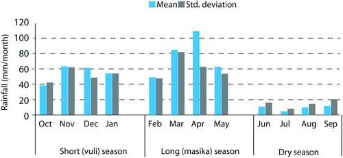
The three research villages Bangalala, Ruvu Mferejini and Vudee (see ) are located in the south Pare Mountains, which form part of the Pangani River Basin, where the climate ranges from semi-arid to dry sub-humid, and the rainfall pattern is bimodal with a ‘short’ rain season called Vuli (October to January) and a ‘long’ rain season (February to May) called Masika (see ).Footnote1
Figure 1. Rainfall seasons in Same (1950–2010), based on data provided by TMA, 2012.
3.1. Ethnic composition of the communities
In Bangalala and Vudee, the majority of the population interviewed belongs to the ethnic group Pare. Ruvu Mferejini is a more dynamic and mixed community which includes the Masai pastoral community that resides in the area dependent on water availability from the Pangani River for their livestock.
3.2. Economic activities and income sources
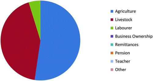
In the three research villages, agriculture is the main economic activity (58% of the surveyed households in Vudee, 57.7% in Bangalala and 52.4% in Ruvu Mferejini). Nevertheless, activities related to livestock are minimal in Vudee as a highland (7%) as compared with Bangalala (23.7%) and Ruvu Mferejini (42.9%) (see Figures ). Vudee has the most income diversification (which corresponds to the highest average years of schooling of the work force) relative to the two other villages.
Figure 2. Main activities of survey households in Vudee. Source: Household survey, 2012.
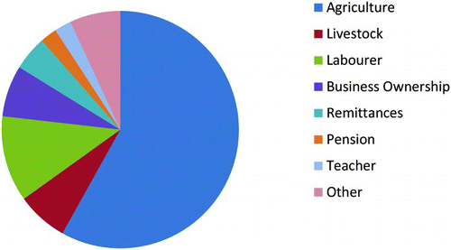
Figure 3. Main activities of survey households in Bangalala. Source: Household survey, 2012.
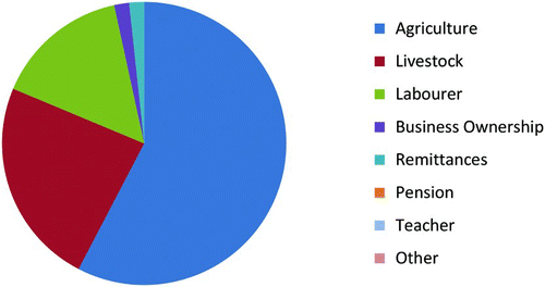
Figure 4. Main activities of survey households in Ruvu Mferejini. Source: Household survey, 2012, 4 Field research findings.
3.3. Overall rainfall patterns
In the research site, the rainfall patterns and their distribution across rain seasons and years have become variable during the past two to three decades (Enfors & Gordon, Citation2007). Although the rain is usually of high intensity, it falls over a short period of time, which makes the water drain into the river networks and alluvial aquifers (Mul et al., Citation2011) and contributes to erosion before reaching the main rivers. This has negative implications for the production of the typical food crops, such as maize and beans (Mutiro, Makurira, Senzanje, & Mul, Citation2006). Therefore, the rainfall variability negatively influences food security of the communities in the three villages. In general, Bangalala (midland – 900 m.a.s.l.) and Ruvu Mferejini (lowland – 655 m.a.s.l.) are subject to less rain as compared with Vudee (highland – 1950 a.s.l.). The average annual precipitation in the research area ranges from 500 to about 1000 mm (Enfors & Gordon, Citation2007).
A scoping study prior to the field research revealed that farmers in Bangalala generally suffer from rain shortage and consequent low crop production. In 2008, Bangalala suffered from an intense drought. Vudee, the village with the highest elevation among the three research villages has also suffered from erratic rainfall that led to crop failure.
3.4. Traditional adaptation strategies to rainfall variability
Although seasonal migration is a typical adaptation strategy for the community in Vudee, some members of the community migrated for long periods or permanently due to severe droughts from 1998 to 2005. As for Ruvu Mferejini, in contrast to the two other villages, farming depends on both rain-fed and irrigated agriculture due to the naturally scarce rainfall, but there are also pastoralists and fishermen. In order for the communities to have a regular and daily source of irrigation water, they rely to a great extent on the traditional Ndivas (water ponds) where the water is stored.
4. Field research findings
shows the socio-demographic and economic profiles that resulted from the household survey across the three research villages. Almost half of the farmers are on the medium scale (49%) in terms of land ownership. Ruvu Mferejini has the highest percentage of large farmers’ households in contrast to Vudee that has the highest percentage of small and landless farmers’ households. Bangalala stands in between (see also average landholding in same table). This suggests that the elevation could play an important role. The communities in the lowlands might have better access to other villages/cities and more mobility. That makes them generate more income (especially regarding livestock business) as compared with the communities in the highlands (highest average farm landholding is in Ruvu Mferejini – 2.11 ha as in shown in ).
Table 1. The socio-demographic and economic indicators at household level in the three research villages.a,b
4.1. Rainfall
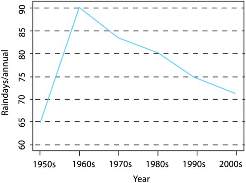
According to the experts from the Tanzania Meteorological Agency (TMA) (Personal communication during Expert Interviews, 14 March 2012), the total amount of annual rainfall has not decreased significantly throughout the past three decades (see ). Nevertheless, the annual rainfall data do not necessarily reflect its distribution and intensity, since large amounts of rain fall in only limited number of days, resulted in crop failure. Since the mid-eighties, the communities have been under longer and more frequent droughts, dry spells within the rain seasons, delayed rain season onsets, earlier rain season cessations and shorter rain seasons than expected; shows the decrease of the total rainy days per annum over the past five decades. Based on the TMA information, the five extreme lowest rainfall events in the district occurred in the years 1952 (314.04), 1975 (320.10), 1993 (302.40), 1996 (318.30) and 2005 (265.30) (mm/annual).
Figure 5. Smoothed annual and seasonal trends of rainfall in Same (1950s–2000s), based on data provided by TMA, 2012.
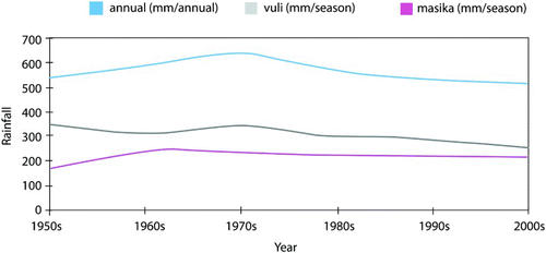
Figure 6. Number of rain days per annum (1950s–2000s), based on data provided by TMA, 2012.
The experts also highlighted the increasing temperature that leads to more evaporation of the reserved water in the traditional Ndivas. This was confirmed by the PRA participants (even in Vudee where the temperature used to be much milder due to its location in the highlands) who reported further that the winds enhanced by the lack of a sufficient vegetal cover often harm the crops before they enter the pollination phase.
The PRA participants in the three research villages reported that in the past 10–15 years, the rains have started later and ended earlier than before in the two rain seasons (confirmed by 68% of households) and have been often interrupted by unexpected long dry spells (confirmed by 84% of households), which made it difficult for the farmers to plan. The household survey reveals that more than 80% of the economies of the households surveyed suffer from rainfall variability.
4.2. Livelihood and food security
The principal crop of subsistence in the site is maize with an average harvest just above 1 ton/ha (FAO, 2008a) and vegetables are the principal cash crops sold at the Same market. Other food crops include lablab, cowpeas, beans, sweet potatoes and onions. The experts stated that the main challenge facing the communities is the occurrence of droughts that aggravate many problems affecting livelihood and food security in the research site as well as in other areas according to the dependence on agriculture and farming activities.
The household survey – considering all three communities together – indicates that the percentage of people engaged in agricultural activities and farming has increased by 30.9% and livestock keeping by 18.8% throughout the past 10 years. This means that farming and livestock keeping have become more significant. As the focus on farming and livestock increased, the overall in situ livelihood diversification decreased. For example, there has been a slight decrease in the percentage of households engaged in casual daily labour by around 2.4% and the reliance on remittances have increased by 4.2% during the same period. This suggests decrease in local employment and increase in the employment of migrants in their destination communities.
Among the most important threats to livelihood facing the communities according to the PRA sessions across the three research villages was rainfall variability (increase in drought incidences, seasonal shifts and prolonged dry spells) and water shortage in the traditional Ndivas. Drought took the first rank in terms of severity. These PRA findings were supported by the household survey that identified drought to be affecting 94% of the households, followed by storms and winds (29.1%).
Regarding food insecurity, food production has decreased over the past two decades. Rainfall variability affected the economy of 82.4% of the surveyed households and 82% have particularly suffered from decreasing income due to declining yields.
Since the climatic and rainfall changes have affected crop production and livestock activities, and thus, the livelihood of the communities, the latter have developed various coping strategies. The relatively wealthy groups tend to store food for future use. The medium groups apply the coping strategies of livelihood diversification, such as casual labouring for payment in food or cash. The activities include firewood sales, charcoal making, brick-making, selling livestock, seeking labour opportunities outside the villages or sending their children for labouring opportunities. Some also migrate to areas with better pastures and more water availability. The poor change their food intake, such as eating more wild edible products or reducing the number of meals or food types they consume; they also seek support from others in the community and government food aid or borrow food from wealthier households. As shown in , the wealth groups in the household survey were listed according to land ownership (small and landless farmers: own 0.004–0.71 ha; medium farmers: own 0.712–1.62 ha; large farmers: own more than 1.624 ha). Other factors considered for wealth ranking were the amount of livestock a household owns (cattle, goats and/or sheep); the size of farmland a household owns; amount of food consumed; the number and type of houses the household owns; the number of assets a household possesses (cars, milling machines, radios, etc.); and the amount of money the household owns at the time of the interview.
4.3. Migration
The migration profile extracted from the household survey shows that the households with migrants in the research villages make up 54% of the total number. Ruvu Mferejini has the highest percentage (59%), followed by Bangalala (53%) and Vudee (49%) (). Elevation could play an important role in the migration decision; the lower the people are located, the more they have access to the surrounding communities. Ruvu Mferejini's reliance on agriculture and livestock rearing, and its difficulties with drought, also make migration a prominent consideration. Moreover, rain abundance in the highland (Vudee) may be another factor that increases the incentive to stay in the home community compared with the lowlands. In addition, as Vudee has the least amount of households whose activities are related to livestock, its inhabitants are less sensitive to rainfall variability.
In general, seasonal migration (less than 6 months) makes up 53.4% versus temporal migration (more than 6 months) that makes up 46.6%. This indicates the reliance of the communities on agriculture and the associated seasonal conditions. The household survey further reveals that the number of economic migrants is twice as large as the number of educational migrants, which means that most people migrate in an attempt to immediately improve their livelihood, with a smaller group migrating as an investment in their future. Categorizing the migrants into landless, small, medium and large farmers, the average number of migrants per household is highest among the large farmers (2.46), followed by the landless (1.18), then the medium (1.06) and small farmers (0.65). From a logical point of view, one would expect that the poorer and less food secure would migrate more in order to improve their livelihoods. However, it is usually the large farmers who possess sufficient means to leave, and their migration decision might not necessarily be related to food insecurity but rather pull factors in the areas of destination. The landless might have a stronger reason to migrate than the medium or small farmers, even if the former must fund their move through loans from others, in order to survive their deprivation and food insecurity. One other factor that might facilitate the migration decision for this category is that the lack of land ownership also removes responsibility and obligations which could otherwise reduce mobility. In addition, there would be no potential land disputes to concern them during their return as it might be in the case of small and medium landholders.
Historically, migration has always existed in the research site, but it has increased in the past three decades and is mainly preceded by droughts. The PRA focus group discussions revealed that people do migrate in search of food, and livestock keepers have to migrate in search of pasture and water. Both decisions highly depend on the climatic conditions. For example, if the long rainy season Masika fails, people migrate mainly from May through August.
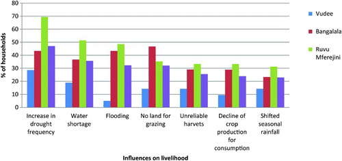
Moving to the factors that were listed in the household survey as ‘very important’ for taking a migration decision. shows that the increase in drought frequency predominates, followed in order by water shortage, flooding, lack of land for grazing, unreliable harvests, decline of crop production for consumption and shifted seasonal rainfalls. It seems that the interviewed household representatives do not consider the seasonal shifts to be a significant problem, as seasonal migration occurs in any case. The same figure shows that it is Ruvu Mferejini that is affected at most, which goes in line with the above observations regarding irregular rain and water shortage as compared with the other villages. In contrast, the same factors seem not to be as important in the case of Vudee, also for the same argument (relative abundance of rain in the village). What confirms this argument is that Bangalala, at a halfway mark between Ruvu and Vudee in terms of poverty, elevation, rainfall and migration, also scored the importance of the factors between the scores of the other two villages.
Figure 7. Factors considered ‘very important’ for the migration decision by the interviewed: Household survey, 2012.
Map 1. Location of the study villages and of the Same District in Tanzania (original map designed based on information collected in the pre-field research, 2012).
In the PRA sessions, migration was ranked very high as a coping strategy for food insecurity across the three villages; people migrate, in a sense by following water, in order to improve their livelihoods and feed their animals. The respondents highlighted that the worst droughts were the ones that significantly disrupted their livelihood system in terms of crop and livestock production and resulted in people migrating to other locations. Furthermore, they complained about the migration strategy, even though it is broadly applied, as it results in the families and dependents being neglected for long periods.
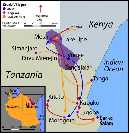
shows the location of the three research villages, the migration destinations, the average precipitation, the agricultural land and the drought frequency/rainfall variability.
Map 2. Destinations of migrants in Vudee, Bangalala and Ruvu Mferejini. (Original map designed based on information collected from the PRA sessions and the household survey).
5. Discussion
The analysis above shows that the rainfall patterns and the degree of their effects on migration vary among the specific villages; the modest migration records in Vudee (highland) can be attributed to the fact that it is the wettest village rainwise (highest precipitation) and the poorest in terms of landholdings, and therefore people might lack the means for migration. At the same time, the generally generous rain gives them less reason to migrate and the higher than average level of education reduces the need for them to send their children elsewhere. Moreover, it has the highest average years of schooling and the most teachers (self sufficiency and no need for schools outside the village). The fact that Vudee has the highest number of elderly as compared with the two other research villages might also contribute to the relative immobility. On the contrary, Ruvu Mferejini (lowland) is the village with lowest precipitation and the richest in terms of landholdings. The mobility of the population in this village as compared with the two others (also see migration arrows on ) could be attributed to its closeness to urban areas (search of jobs to improve livelihood – pull factors), as well as the largest representation of pastoral communities that need to feed their livestock and are therefore more sensitive to water availability (Ruvu Mferejini has the highest percentage of people dependent on livestock activities from the three villages). The relatively great wealth of the village might give the communities better opportunities to migrate, and at the same time, this wealth might be attributed to their access to urban centres (remittances). Bangalala (midland) lies in between regarding all these variables, including migration.
6. Conclusions and recommendations
Rainfall variability has a clear effect on food security of the communities of the three research villages, and hence, on their human mobility. More than 80% of the economies of the households surveyed have been affected by rainfall variability. Frequent droughts and water shortage are the top factors that influence migration in the overall research site. Diverse levels of elevation and precipitation – among other socio-economic factors – across the three villages of research are associated with respectively various migration patterns. In the highest, wettest and poorest village with the highest rate of education and with the oldest population age wise, out-migration is the least.
It is important that the traditional Ndivas are well maintained and used on a larger scale, such that the water stored in them can be used more broadly and can provide the maximum amount of land with water for longer periods. It is also essential that the Ndiva water is economized, so that the negative effects of evaporation are mitigated. Moreover, it is crucial that the communities who prefer to stay or cannot afford to migrate receive support. Making use of the remittances in a systematic way (development projects and micro-scale investments) can support their livelihoods in situ. As to the migrants, their value added to the areas of destination should be maximized by involving them in activities that match their skills (e.g. farming and construction), so that they actively contribute to the overall welfare of the new areas on one hand and to the well-being of themselves and their families on the other.
Acknowledgements
We are deeply indebted to Dr. Koko Warner, Head of Section at United Nations University Institute for Environment and Human Security (UNU-EHS) and Scientific Director of the ‘Where the Rain Falls’ project; Mr. Kevin Henry (CARE France), project coordinator and Ms. Aurélie Ceinos (CARE France), project officer. We are grateful to the national and local offices of CARE Tanzania and their research team as well as to Ms. Verena Rossow (UNU-EHS) for the literature review, maps and graphs as well as Mr. Serge Birtel and Ms. Hana Sherin Galal (both at UNU-EHS) for their statistical support. Last but not the least, we would like to thank the AXA Group and the John D. and Catherine T. MacArthur Foundation for generous funding of the research.
Notes
1. The duration of both seasons is similar on average, but the reason why one is called ‘short’ and the other ‘long’ is that the average amount of rain water of the first season is less than the second, respectively.
Related Research Data
References
- Afifi, T., Govil, R., Sakdapolrak, P., & Warner, K. (2012). Climate change, vulnerability and human mobility: Perspectives of refugees from the East and Horn of Africa (Report No. 1. Partnership between UNU and UNHCR). Bonn: United Nations University Institute for Environment and Human Security (UNU-EHS).
- Afifi, T., & Jäger, J. (2010). Environment, forced migration and social vulnerability, Heidelberg, Germany: Springer.
- Afifi, T. & Warner, K. (forthcoming, 2014). Where the rain falls: Evidence from 8 countries: How households use content and erosive migration to manage the risk of rainfall variability and food insecurity. Climate and Development.
- Enfors, E., & Gordon, L. (2007). Analyzing resilience in dryland agro-ecosystems: a case study of the Makanya catchment in Tanzania over the past 50 years. Land Degradation and Development, 18, 680–696. DOI: 10.1002/ldr.807
- Food and Agriculture Organization (FAO). (2002a) Agro-MAPS: global spatial database of agricultural land-use statistics. Retrieved September 20, 2012 from http://www.fao.org/landandwater/agll/agromaps/interactive/page.jspx
- Food and Agriculture Organization (FAO) (2002b). The State of Food Insecurity in the World 2001, Rome, Italy: The Food and Agriculture Organization of The United Nations Viale Delle Terme Di Caracalla
- Foresight (2011). Migration and global environmental change: final project report, London: Government Office for Science.
- HBS. (2007). Tanzania National Budget Survey Report. National Bureau of Statistics, Ministry of State President's Office, Planning and Privatisation.
- Intergovernmental Panel on Climate Change (IPCC). (2001). Climate change 2001 (Synthesis Report). Cambridge, UK: Intergovernmental Panel on Climate Change. (IPCC). Cambridge University Press.
- Jäger, J., Frühmann, J., Günberger, S., & Vag, A. (2009). Environmental change and forced migration scenarios project synthesis report. Retrieved from http://www.each-for.eu/documents/EACH-FOR_Synthesis_Report_090515.pdf
- Liwenga, E.T., Kwezi, L., & Afifi, T. (2012). ‘Where the rain falls’ project. case study: Tanzania. Results from the Same district, kilimanjaro region (Report No. 6). The United Nations University Institute For Environment and Human Security, Bonn, Germany.
- Mul, M. L., Kemerink, J. S., Vyagusa, N. F., Mshana, M. G., van der Zaag, P., & Makurira, H. (2011). Water allocation practices among smallholder farmers in the South Pare Mountains, Tanzania: The issue of scale. Journal of Agricultural Water Management, 98, 1752–1760. DOI: 10.1016/j.agwat.2010.02.014
- Mutiro, J. H., Makurira, H., Senzanje, A., & Mul, M. L. (2006). Water productivity analysis for smallholder rainfed systems: A case study of makanya catchment, Tanzania. Journal of Physics and Chemistry of the Earth, 31(15–16), 901–909. DOI: 10.1016/j.pce.2006.08.019
- NEP. (1997). The Republic of Tanzania, National Environmental Policy, Vice President's Office, Dar es Salam. Retrieved from http://www.tzonline.org/pdf/nationalenvironmentalpolicy.pdf
- Rademacher-Schulz, C., Afifi, T., Warner, K., Rosenfeld, T., Milan, A., Etzold, B., & Sakdapolrak, P., (2012). Rainfall variability, food security and human mobility. An approach for generating empirical evidence (Intersections No. 10). Bonn, Germany.
- Tanzania Invest. (2012). Tanzania economy. Retrieved from www.tanzaniainvest.com/tanzania-economy
- Van Aalst, M., Hellmuth, M., & Ponzi, D. (2007). Come rain or shine: Integrating climate risk management into African Development Bank operations (Working Paper, No. 89), African Development Bank (AfDB).
- Warner, K., Erhart, C., de Sherbinin, A., Adamo, S. B., & Onn, T. C. (2009). In search of shelter: Mapping the effects of climate change on human migration and displacement, A policy paper prepared for the 2009 Climate Negotiations. Bonn, Germany: United Nations University, CARE, and CIESIN-Columbia University and in close collaboration with the European Commission “Environmental Change and Forced Migration Scenarios Project”, the UNHCR, and the World Bank