
Abstract
The impacts of rainfall variability are threatening food production systems, leading to losses of livelihood and food insecurity. The frequency and intensity of floods and drought are likely to be higher as a result of climate change. This case study presents an empirical account of the impacts of rainfall variability on agriculture, food security, livelihoods and human mobility in the Janjigir-Champa district of Chhattisgarh. The research tests the hypothesis that human migration is a major coping mechanism against climate variability. The findings confirm that a coordination mechanism exists between rainfall changes (i.e. erratic rainfall patterns in terms of delayed monsoons, seasonal shifts, drought and floods) and livelihood and food security of a number of farmers and farm labourers in the research site. Because there is only a single annual harvest of paddy rice (practiced as monoculture) in the research site, which is partly due to the non-availability of water for a second crop, marginal farmers and farm labourers are left with very few options in finding sufficient employment in and around their villages. Some people cope with the situation by seeking assistance from their relatives, friends and the government. However, seasonal and permanent migrations are the most opted-for coping strategies in the study area.
1. Introduction
Changing weather patterns such as less predictable seasons, increasing events of erratic rainfall or prolonged droughts are the most important factors threatening the sustainability of agriculture and food security (IPCC, Citation2001). Dwindling agricultural productivity interacts with a range of escalating stresses on rural livelihoods, that is, land pressure, soil erosion, deforestation and depleted water resources that would otherwise exist regardless of the climate change (Iglesias et al., Citation2007). When livelihoods are subjected to continuous stress, farmers and farm labours might migrate either seasonally, temporarily or permanently and consider it as the most immediate coping strategy (Afifi, Citation2011; Afifi & Warner, Citation2008).
This article investigates whether this applies to four villages in the Janjgir-Champa district of Chhattisgarh state, India. It essentially addresses the three pillars of sustainability: economic (agriculture and livelihood); environment (rainfall and climate); and social (poverty and migration); and uses inductive and deductive approaches to help narrow down the focus from theory to practice and from global to local. An overarching attempt is made to study the inter-linkages between these three pillars from the climate change adaptation perspective. A combination of qualitative (expert interviews and a total of 53 Participatory Research Approach – PRA sessions) and quantitative research are used in the field (Rademacher-Schulz et al., Citation2012). The sample size of the household survey is 180, broken down to four villages. Moreover, the research is supported by meteorological data and information about the rainfall patterns and changes in the research site. The field research took place from 29 October to 19 November 2011.
Limitations encountered by this study were broadly categorized as methodological shortcomings and physical difficulties. Lack of sufficient baseline data, lack of sufficient time to conduct the PRA sessions and expert interviews were some of the limitations faced. Due to the non-availability of detailed household level information, simple random sampling for the household survey was used. To minimize the impact of these limitations, the research team was sufficiently oriented to use proxy indicators to obtain the correct information. Triangulation was also carried out to improve the reliability and validity of this research.
2. Research setting
2.1. Site selection
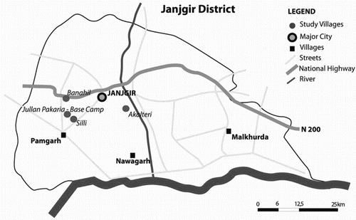
A rich amount of literature suggested Chhattisgarh state and Janjgir-Champa district in central India as one of the potential sites for carrying out the research. Although Janjgir-Champa is not entirely rainfall dependent for agriculture and other livelihoods, the rainfall patterns, poverty trends and presence of a large number of seasonal migrants qualify this district for the study. Other studies and experts suggested the Mahasamud and Sarguja districts of the same state to be considered for this research. However, a number of factors, such as rapid industrialization, conflicts of interest between local people and governments on land acquisition for industrial development, water sharing disputes in the irrigation facilities, and possibilities of mobilizing logistical support for the field study, guided the team to finally consider Janjgir-Champa district as the study area. The four villages covered by the research were Akalteri, Banahil, Jullan Pakaria and Silli ().
Figure 1. Location of study villages.Source: Verena Rossow (2012).
2.2. Profile of study area
Chhattisgarh lies between 17°47′ and 24°06′N latitude and 80°15′ and 84°24′E longitude. The state measures 640 km from north to south and 336 km from east to west with a total area of 135,194 km2. Janjgir-Champa district, where the research was carried out, is a relatively new district bifurcated from the undivided Bilaspur district. According to the 2011 Population Census Report (Government of India, Citation2011), Janjgir-Champa has 15 small towns and 892 villages. The district has a total population of 1,620,632 people with 816,057 males and 804,575 females. The district registered a population growth of 23.01% in the last decade.
2.3. Socio-demographic and economic characteristics of the surveyed households in the research site
Although the four villages of the study are treated as one unit, some differences among the villages were observed and are worth mentioning in the article. shows the main characteristics of the households of the survey conducted in the four research villages. The majority of the population belongs to the marginalized groups in terms of castes and tribes. Jullan Pakaria has the highest percentage of Most Backward Classes (MBCs). Land ownership is used as a proxy for wealth/poverty. The village Silli has the highest percentage of landless households and at the same time the highest percentage of households with migrants. This indicates that there could be a correlation between being landless and the willingness to migrate due to a lack of commitment back home. Banahil has the highest percentage of small landowners (50%) and Akalteri the highest percentage of large and very large landowners (48%).
Table 1. Socio-demographic and economic characteristics of the surveyed households in the research site.
2.4. Methodology used in the research site
The field research combined expert interviews (government officials, environmental and migration scholars, meteorological specialists and non-governmental organization representatives), a household survey and PRA sessions with the communities (Rademacher-Schulz et al., Citation2012; Warner & Afifi, Citationin press). The PRA sessions included – but were not limited to – Focus Group Discussions (to allow for open discussions about various issues of research interest), seasonality calendars (to address issues related to seasonal rainfall), timeline and trend analysis (to detect the good and bad years and months in terms of rainfalls and link that with food insecurity and migration patterns), risk ranking (to understand the threats the communities are facing and the way how they cope with and adapt to them), Venn diagrams (to get informed about the institutions and individuals that play a role in securing the food availability for the communities) and mobility maps (to find out the areas of destinations the communities reach when migrating). There were separate PRA sessions for women, men, elderly, farmers, non-farmers and marginalized separately, but there were also heterogeneous and mixed sessions with diverse characteristics. The researchers made sure not to exclude any castes residing in the villages from the survey. The household survey included questions directly and indirectly related to the three main variables of the study, namely rainfall variability, food (in)security and human mobility. Although national meteorological data were considered an important information source, having access to corresponding data that link the weather changes to migration flows in the research site was a challenge. Due to this research limitation, the main source of information remained the expert interviews, the household survey and the PRA sessions.
3. A brief overview of rainfall variability, food security and human mobility in Chhattisgarh
3.1. Rainfall variability and agricultural productivity
The Indian monsoon period, from 1871 to 2009, shows a well-defined epochal variability with each epoch of approximately three decades. Although it does not show any significant trend, when averaged over this period, a slight negative trend i.e. 0.4 mm/year is seen. Pockets of increasing/decreasing monsoon rainfall trends have been reported in 36 meteorological sub-divisions across India. Particularly, central India depicts a decreasing trend, which is significant over Chhattisgarh and east Madhya Pradesh (MoEF, Citation2010).
Analysis of the rainfall data for the state of Chhattisgarh showed that blocks in the central part of the state, adjoining Janjgir-Champa, Raipur and Bilaspur experience low average annual and average seasonal rainfall (Gupta, Citation2002). Rural areas in the state are most vulnerable to impacts of disasters and climate change. With a significant population dependent on rain-fed agriculture, animal husbandry, fisheries, and forest-based livelihoods, any change in precipitation and temperature patterns could significantly impact lives of the vulnerable communities (Planning Commission, Government of India, Citation2011).
3.2. Food security and livelihood
In Chhattisgarh, rice is the main crop-grown in about 3.7 million hectares, covering 77% of the net sown area. Small and marginal farmers cultivate 38% of the cropped area but constitute 75% of the state's cultivators. Only about 20% of the area is under irrigation, and the rest is under rain-fed conditions. Due to the change in rainfall patterns, a shift in the monsoon in terms of delayed onset farmers in Chhattisgarh has adopted various measures; the farmers earlier used to grow long duration tall varieties of rice which flower in the month of October and mature by the middle of November. As a consequence of decreasing rainfall trends, especially in the month of October, the long duration varieties started failing and farmers have more and more relied on short or medium duration rice varieties for the past 10 years (Sastri, Citation2009). Although the situation has improved in other states of India, child malnutrition rates in Chhattisgarh continued to be above 50%, even in the past decade (Pathak & Singh, Citation2011).
3.3. Human mobility and migration due to rainfall variability
In Chhattisgarh, seasonal migration in search of wage labour is very common in many districts. Most of the migrants are farmers with little land holdings who were able to grow only one crop of rice in a year. After one season of agricultural employment, a large number of landless farm labourers choose seasonal migration due to the lack of productive assets or availability of alternative employment options in the villages. People who belong to the MBC, scheduled castes and scheduled tribes migrate in large numbers. Since the state has the lowest share of irrigated land (20%), families cannot sustain themselves on rain-fed agriculture, given the problems facing the latter (Anon, Citation2008). Despite the creation of nearly 5911 lakh person days of work under the Mahatma Gandhi National Rural Employment Guaranty Act (MGNREGA) during the 11th five year plan period, rural out-migration has increased in the recent years, suggesting the higher risks faced by the vulnerable rural populations (Planning Commission, Government of India, Citation2011)
4. Field outcomes and discussion around the Janjgir-Campa district
4.1. Climate and rainfall variability
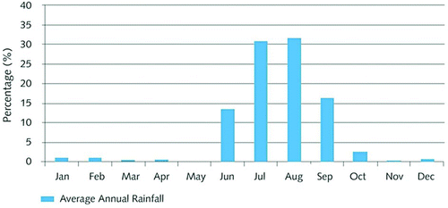
Desk work analysis of rainfall data for the Janjgir-Champa district for a 30-year period from 1981 to 2010 showed that the dominance of south-west monsoon accounted for more than 90%of the annual rainfall between the months from June and September (). The average rainfall for August is 387.8 mm, which is the highest and contributes to 31.55% of the annual rainfall in the region. The July rainfall is slightly lower and contributes about 31% of the annual rainfall. July and August rainfall were almost similar, and they contribute 62% of the total annual rainfall. The average south-west monsoon rainfall (>1,100 mm) contributes more than 90% of the annual rainfall. The linear trend shows slight decreases in the average annual rainfall pattern throughout the 30-year period. shows the average annual and monsoon rainfall in Janjgir (1981–2010).
Figure 2. Comparison of annual rainfall and monsoon pattern in Janjgir (1981–2010).Source: Field survey analysis.
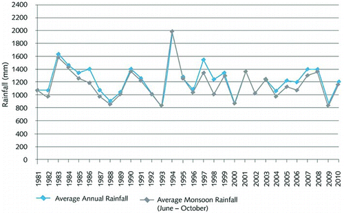
Figure 3. Average annual and monsoon rainfall in Janjgir (1981–2010).Source: Field survey analysis.
According to expert interviews, the total number of rainy days per year has decreased from 65 to 56 in the past decade. This was also reported during the PRA sessions carried out across the four villages and confirmed by more than 59% of the survey households. Through the seasonality calendars, the PRA participants reported the changing rainfall patterns, such as delayed rainfall, erratic rain and dry spells. shows that the majority of the households (58.3%) have not observed any floods over the past three decades (1981–2010). However, 34% of the households sensed that the droughts and dry spells have increased, 18% of which even believe that the droughts and dry spells are currently ‘a lot more’ than before. 37.7% reported their observation of increasing extreme weather events over the past three decades. As demonstrates, 59.4% of the households have been suffering from shorter rainy seasons in the past three decades (Murali & Afifi, Citation2012).
Table 2. Perception of climatic changes in the households.
Table 3. Rainfall changes observed by the households.a
Water from the Bongo Reservoir is provided to 247,000 hectares of farmland through canals for the monsoon crops from July to September. About 40,000 hectares of land receive water for winter crops from January to March. Seasonal changes and rainfall patterns will determine water availability in the dam for winter crops and the extent to which farmlands are to be irrigated. Therefore, water availability for a second crop to paddy rice in a year largely depends on the rainfall pattern in the catchment area of the dam.
4.2. Livelihood and food security
Since agriculture is the major livelihood activity of the communities living in the area, most of the discussions during the PRA sessions revolved around the challenges and risk factors related to agriculture. Although the yield has gone up since 2000, and reported regionally and nationally as an achievement, it does not capture the complex dynamics involved between farmers, farm labourers, farming practices and more importantly the cost of productivity. Some of the key challenges of agriculture in the study area were delayed monsoons; single annual harvest; recurrent crop diseases; input-intensive unsustainable agriculture; labour shortage during peak harvesting seasons; and poor support price for the producer. Monoculture of rice has been practiced in the region for hundreds of years for cultural and traditional reasons, which include food consumption habits, soil conditions and flood irrigation patterns forcing the farmers to go for only the rice crop in the study area. Local government representatives interviewed in the research area recommend the farmers to diversify their agricultural production, but according to the PRA participants, most of the times, the canal water provided by the government does not allow for a second crop to paddy rice. The PRA participants further reported that the government favours the new power plants in the area at the expenses of the farmers when distributing the canal water.
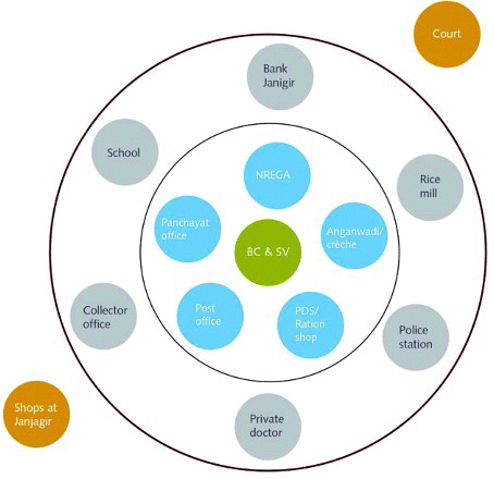
The Venn diagram () designed by the PRA participants reflected their access to food in the study sites. They informed that local institutions, such as village Panchayat offices (institutions of local self-government elected by people every five years), Anganwadi centres (crèche/mid-day meal and nutrition programme to pre-school children in a village), ration shops (fair price public distribution system) and post offices (through which direct remittance of wages from the government and money transfer by migrant worker to his family takes place), are considered the key institutions positively impacting their food security. From the PRA exercise and expert interviews, it is clear that the existing coping mechanisms, such as the below poverty line assistance programme and MGNREGA providing guaranteed employment to poor families, have not always functioned as expected due to various operational and implementation constraints.
Figure 4. Consolidated Venn diagram on access to food security depicting key institutions/organizations/individuals.Source: PRA sessions.
presents the coping and adaptation strategies used by interviewed households facing food shortage. From the household survey, it seems that people use external help (including remittances and borrowing from others) as the first option (37.8%). This is followed by reducing the food consumption (23.3%) and/or the overall household expenditures (18.3%). 22.2% of the interviewed households opt for out-migration to search for better livelihoods or to be able to send remittances back home. These results go in line with the outcomes of the PRA sessions.
Table 4. Coping and adaptation strategies used by households in response to food shortages.
4.3. Migration and human mobility
As captured by the community, the Focus Group Discussions convey that migration is viewed as a major coping mechanism against all livelihood risks, including rainfall variability. Nevertheless, experts interviewed from local government departments deny drought-induced migration and rather defend their drought relief programmes and other anti-poverty programmes.
Earlier studies (Gupta, Citation1993; Mitra, Citation2003; Potdar, Citation2008; Salve, Citation2009) confirmed that due to monoculture of paddy cultivation, marginal farmers and farm labourers used to seasonally migrate for six months to other places in search of alternative livelihoods. However, there are other exogenous pull factors, such as globalization, rapid economic development of cities and towns that attract people to improve their economic prospects.
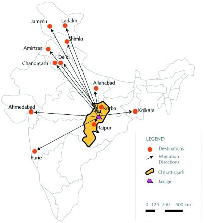
The PRA sessions and household survey show that village people migrate to various places for seeking alternative livelihoods. According to the respondents, they move to Jammu, Ladakh, Shimla, Pathankot, Amirtsar, Delhi, Kolkata, Allahabad, Lucknow, Pune and Ahmedabad to work in brick kilns, construction sites. Within Chhattisgarh state, they move to Korba and Raipur, Akaltara and Janjgir to work in shops and rice mills. More insights into the migration destinations are shown in . Relatives and friends influence the migrants in choosing destinations. In most cases, informal labour contractors/agents approach the potential migrants and facilitate informal contracts with the employers in the migration destinations. Generally, the migrants will return after six months before the monsoon to prepare the land for the next crop. However, some who find attractive job conditions and are landless tend to stay back for a little longer than a year. Thus, seasonal migration can easily turn to longer term migration in the study site.
Figure 5. The main areas where migrants from all the study villages head to for alternative livelihoods.Source: Household survey and PRA sessions
It was reported in the PRA sessions that many people migrate in families who take their children out of school to assist the parents in the destination areas. There are no specific patterns emerging in terms of family members accompanying the primary migrants. However, it was sensed from the PRA sessions that the communities had problems related to the quality of schooling, in addition to the reduced annual period of school attendance as well as entire school dropouts caused by frequent migration in the extreme cases. Very few migrants reported about unhealthy living conditions, hard labour, and threat from locals in migration destinations.
shows that 41.6% of the studies households have migration experience. The majority of the migrants seek better livelihoods (87.7%) and an improvement of their financial situation as compared to educational migrants who make up only 1.8%of the migrants within the household sample. The household survey also reveals that 61.8% of the migrants are males, although the PRA sessions showed clearly that people rather migrate in families. The seasonal migration is the most dominating type, which indicates that the weather has an important impact on such a decision. The majority (57.5%) of the migrants are still away and have not yet returned.
Table 5. Classification of migrants in the research site.
It is clear from field-based evidence that there have been many circumstances which led to the communities in the villages to choose migration as a major coping strategy. This has occurred after the majority of the support systems have either failed or proved to be inadequate to ensure access to services and entitlements at their destinations.
4.4. Linkages between rainfall variability, food security and human migration
There is a clear link between the three variables. However, other intervening demographic, historical/cultural, institutional, social and economic factors influence the dynamics between these variables and they should not be overlooked in the research. Seasonal shifts are definitely an issue in the research site. Although a large proportion of land is irrigated by canal water, rainfall still has an impact on the availability of the canal water, in the water ponds, in the water wells and on rain-fed agriculture. People complain about the shortage of canal water which leads to shortage in food production, referring to unfair distribution in favour of the power plants. Based on the Environment Impact Assessment reports approved by the Ministry of Environment and Forests, Government of India, a total of 29 coal-based thermal power plants in Janjgir-Champa would be established by private companies with the total generation capacity of 62,420 Mega Watt of electricity. According to the Caveland Environmental Authority/Water Report, 2012, a typical 4,000 MW Ultra Mega Power Plant consumes around 110 million cubic metres of water per year, the equivalent of the water of 22,000 hectares of irrigated land (Smart & Adam, Citation2012). If all the power plants are commissioned and become operational in Janjgir-Champa district, it would require water which is used for irrigating 350,000 hectares of agricultural land. The new power plants that–according to the PRA participants – pollute the air do not absorb enough labour from the communities interviewed, due to a lack of appropriate skills. Therefore, they often opt for migration, while the power plants ‘import’ workers from other regions who possess these required skills. The District Collector denies that the power plants are an obstacle for the locals and refers the responsibility for the shortage in food production to the monoculture system.
The household survey also conveys the perception of the changing rainfall impact on food production. This is reflected in where 42% of the respondents indicated that rainfall changes did affect food production a lot. Also, 31% mentioned that it affects their food production to a lesser extent. In total, 73% of the respondents' food production is affected by rainfall in one way or another. When referring to , one observes that migration is one of the coping strategies in response to food insecurity. These outcomes are supported by that shows the triggers of migration within the interviewed households; the most important trigger is insufficient income (96.6% of the respondent households). Since the majority of households is engaged in agriculture, it is most likely that the decline of income is linked to a poor crop production that also has its negative effects on food security. Of the respondent households, 54.5% state that the decline in crop production (which also has direct implications on food consumption and security and is to a great extent caused by challenges related to rainfall) is an important trigger of migration. Almost 40% of the respondent households mentioned that migration was caused by the seasonal shifts. One should not overlook, however, that the pull factors, such as better job opportunities in urban areas (70.9% of respondent households) are also important triggers of migration.
Table 6. Household perceptions about rainfall impact on food production.
Table 7. Household triggers of migration.a
The remittances play a role in maintaining food security within the households; the household survey revealed that the remittances are mostly used in food consumption, followed in order by health care, purchase of consumer goods and repayment of debts.
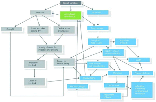
The impact diagram resulting from the PRA sessions and provided in gives more detailed and interesting insights into the participants' perceptions; less rain leads to drought, drier ponds and lakes as well as declining groundwater. All this has its negative implications on the general water availability for humans (less income and employment opportunities), animals (death of livestock) and agriculture (crop failure and declining yields) in the research site. In all these cases that largely contribute to food insecurity, people seek adaptation strategies to improve their livelihoods. Some of the PRA participants borrow money from friends, relative or relevant institutions and others migrate in search of improved livelihoods and for sending remittances. Even those who borrow money in situ often need to migrate, in order to earn money that helps them repay their loans. Hence, the relation between rainfalls variability, food insecurity and human mobility is clear in the case of the four research villages of Janjgir-Champa district.
Figure 6. Impact diagram of local community against rainfall variations.Source: PRA sessions.
5. Summary and conclusion
Changing rainfall patterns in terms of drought, shorter and shifting rainy seasons as well as erratic rain have a negative impact on the food security and livelihoods of the communities in the research area. It is clear that migration is caused directly (shorter and delayed rain seasons) and indirectly (decreased income due to less crop production caused in turn by less rain) by water scarcity. Although most of the agriculture depends on irrigation by the canal water, the availability of rain water does affect people, the livestock and the crops, especially because the canal water depends on the availability of rain water. Additionally, the communities explicitly mention that the new power plants in the region compete for the canal water and fresh air, and crowd them out by employing people from other regions. The interviewed government representatives blame the monoculture of paddy as a food security threat for the farmers, while the latter in turn refers to the unavailability of sufficient canal water as a reason for them not to grow a second annual crop. It is likely that recognizing drought-induced migration would also be viewed as a failure of government mechanisms; and therefore, government agencies might on one hand rather highlight the monoculture issue and on the other heavily underreport migration.
As a result, some of the people are migrating to other places in search of better/alternative livelihoods. Although the communities are also attracted by the pull factors in urban areas, when they move there, they face new types of challenges. In the areas of destination, they are not necessarily surrounded by the best circumstances, which creates other challenges for them and their families. In addition, there are negative implications on child education, in cases where people migrate in families and stay away for longer than six months a year.
A useful strategy would be considering the locals – who constantly suffer from low food production caused by rainfall problems – in the power plants by providing them with the necessary corresponding skills, in order for them to have improved or even alternative livelihoods in the case of water patchiness or crop failure, without having to move elsewhere.
Since the rain resources are limited in the area of study and likely in other similar areas in the same and in other regions, and it is not foreseen that this situation might improve in the near future, then the most relevant recommendation would be making the best out of the available resources. It is crucial to raise awareness of the farmers about the importance of rationalizing the usage of the little water available in ponds and the necessity of not polluting it by using it as a sewer for disposing human and animal wastes. Raising awareness among farmers about the possibility of diversifying the agricultural production by introducing new crops could also be useful for the overall benefit of communities, specifically in terms of improved food security and reduced vulnerability. Nevertheless, it is advisable that in return, the decision-makers in the district balance the accessibility to the canal water between the farmers and the power plants, such that both activities work in parallel and the gains of the limited resources in both sectors are maximized.
Related Research Data
References
- Afifi, T. (2011). Economic or environmental migration? The push factors in Niger. International Migration, 49(s1), e95–e124. International Organization for Migration, Special Issue, Oxford, UK.
- Afifi, T., & Warner, K. (2008). The impact of environmental degradation on migration flows across countries. (Working paper No. 5/2008). Bonn: United Nations University – Institute for Environment and Human Security (UNU-EHS). Retrieved January 21, 2013, from http://www.ehs.unu.edu/article:476?menu=94
- Anon. (2008). Distress migration – identity and entitlements: A study on migrant construction workers and the health status of their children in the national capital region 2007–2008. New Delhi: Mobile Crèches Publication.
- Government of India. (2011). Census of India: Provisional report 2011. Registrar general and census commissioner, Ministry of Home Affairs. New Delhi, India: Government of India.
- Gupta, M. (1993). Rural-urban migration, informal sector and development policies: A theoretical analysis. Journal of Development Economics, 41(1), 137–151. doi: 10.1016/0304-3878(93)90040-T
- Gupta, S. (2002). Water policy for drought proofing Chhattisgarh. New Delhi: Institute for Human Development, New Delhi for the Planning Commission of India.
- Iglesias, A., Avis, K., Benzie, M., Fisher, P., Harley, M., Hodgson, N., … Horrocks, L. (2007). Adaptation to climate change in the agricultural sector. Report prepared for European Commission Directorate General for agriculture and rural development. Spain: AEA Energy & Environment.
- IPCC. (2001). Climate change 2001: Synthesis report. Contribution of working groups I, II, and III to the third assessment report of the intergovernmental panel on climate change, R.T. Watson and the Core Writing Team, ed. Cambridge: Cambridge University Press.
- Ministry of Environment and Forests. (2010). Climate Change and India: A 4X4 Assessment. A sectoral and regional analysis for 2030s, Indian Network for Climate Change Assessment (INCCA) Report 2. Ministry of Environment & Forests, Government of India, New Delhi.
- Mitra, A. (2003). Occupational choices, networks and transfers: An exegesis based on micro data from Delhi slums. New Delhi: Manohar.
- Mobile Creches. (2008). Distress migration – identity and entitlements: A study on migrant construction workers and the health status of their children in the national capital region 2007–2008. New Delhi: Mobile Crèches Publication. Retrieved January 21, 2013, from http://www.mobilecreches.org/userfiles/file/Distress%20Migration%20_%20Identity%20and%20Entitlements%281%29.pdf
- Murali, J., & Afifi, T. (2012). “Where the Rain Falls” project. Case Study: India. Results from Janjgir-Champa District, Chhattisgarh State. Report No. 4. Bonn: United Nations University Institute for Environment and Human Security (UNU-EHS).
- Pathak, P.K., & Singh, A. (2011). Trends in malnutrition among children in India: Growing inequalities across different economic groups. Social Science and Medicine, 73(4), 576–585. doi: 10.1016/j.socscimed.2011.06.024
- Planning Commission, Government of India. (2011). Faster, sustainable and more inclusive growth, an approach to the twelfth five year plan (2012-17), New Delhi.
- Potdar, B.R. (2008). Labour and industrial law in Madya Pradesh/Chhattisgarh. Indore: Wadhwa & Company.
- Rademacher-Schulz, C., Afifi, T., Warner, K., Rosenfeld, T., Milan, A., Etzold, B., & Sakdapolrak, P. (2012). Rainfall variability, food security and human mobility. An approach for generating empirical evidence. Intersections No. 10. Bonn, Germany: United Nations University Institute for Environment and Human Security (UNU-EHS).
- Salve, W.N. (2009). Labour rights and labour standards for migrant labour in India. Retrieved January 21, 2013, from http://www.ilo.org/legacy/english/protection/travail/pdf/rdwpaper22a.pdflaborrights.pdf
- Sastri, A.S.R.A.S. (2009). Long range regional climate fluctuations/changes and their impacts on agriculture: A case study for Chhattisgarh State in Central India. Workshop proceedings: Impact of climate change on agriculture, India. ISPRS Archives XXXVIII-8/W3, Raipur.
- Smart, A., & Adam, A. (2012). CEA/ Water report, water and the electricity generation industry. (Waterlines Report Series No 18). National Water Commission, Australian Government. August 2009.
- Warner, K., & Afifi, T. (in press). Where the rain falls: Evidence from 8 countries on how vulnerable households use migration to manage the risk of rainfall variability and food insecurity. Climate and Development. doi:10.1080/17565529.2013.835707