
ABSTRACT
This study validates local forecast indicators used by indigenous Aymara in Bolivia’s Northern and Central Altiplano. In Bolivia, the use of traditional forecasting methods is declining even though climate services cannot provide useful forecasts because of a low density of stations and lack outreach services. Validating local knowledge can reduce the erosion of local knowledge by resolving debates over their utility within communities and by gaining support of public agencies charged with promoting indigenous knowledge. The research had three phases, first key informants identified forecast indicators, then 95 farmers were asked to evaluate their reliability. In the North, four indicators were rated as highly reliable and in the Central region, three. Finally, a seasonal forecast indicator and two indicators of the onset of rains were evaluating using historical meteorological data. The seasonal indicator was the minimum temperature on the Fiesta de San Juan, and the rainy season onset was the flowering pattern of two plant species. The minimum temperature explained 55.5% of the variance in growing season precipitation. Flowering patterns are affected by severe frosts, and there was a correlation between frosts and later rains. Results show local knowledge’s potential for improving agrometeorological forecasts and for managing weather-related risks.
1. Introduction
Farmer’s abilities to reduce climate-related risks are greatly enhanced if they can receive useful and reliable weather forecasts (Bright et al., Citation2013). However, the lack of strong weather forecasting systems in many middle and low-income countries hampers the development of useful forecasts. This is one of the reasons that many argue that the co-production of forecasts using local and scientific knowledge is the best way to produce actionable forecasts. The provision of climate services is particularly challenging in tropical mountainous and highland areas like the Andes where topography and thin air create a variety of microclimates within relatively small areas – making it more difficult to marshal sufficient resources to scale forecasts (González-Zeas et al., Citation2019). This report focusses on an effort to validate local forecast knowledge in the Bolivian Altiplano as a first step towards the co-production of useful agricultural forecasts. The Altiplano is in the heartland of pre-Columbian civilizations that developed sophisticated weather forecasting systems to manage climate-related risk. However, in recent years the use of these forecasting methods has rapidly declined, and many farmers doubt whether local forecast indicators are relevant under current conditions of rapid ecological, climatic, social, and economic change (Gilles et al., Citation2014). This decline is occurring even though there has been research that shows the potential value of traditional forecasting (Orlove et al., Citation2002). At the same time the use of traditional forecast methods has declined, small farmers have not had access to agricultural forecasts produced by SEHNAMI, Bolivia’s meteorological service.
The results presented here are the product of a 15-year collaboration between indigenous Aymara communities and agronomists and meteorologists at the Universidad Mayor de San Andres (UMSA) to create useful agricultural forecasts. Here we present one result of this collaboration, an examination of whether traditional forecasts methods are relevant under current social, economic and environmental conditions. Validating forecast indicators can strengthen the production of useful local knowledge by contributing local debates and by providing information to public schools and local governments which are charged by the national constitution with promoting and preserving local knowledge. In addition, an understanding of the physical conditions influencing natural forecast indicators has the potential of adding to our basic understanding of the meteorology of the Andean region.
Next, we describe the research literature on local knowledge and climate before going on to discuss our research setting and problem.
2. Previous research
Much has been written about the potential of indigenous and local knowledge to improve rural development and conservation strategies. Some authors use the terms local and indigenous knowledge interchangeably, others do not. (Sillitoe, Citation2010). There has been considerable debate over the definition of indigenous and local knowledge (Sillitoe & Marzano, Citation2009). Does local knowledge include all the contextualized and experiential knowledge, or only ancestral knowledge? Is the environmental knowledge farmers, fishers and loggers who are part of the majority culture indigenous or local?
We use the term ‘local knowledge’ instead of ‘indigenous knowledge’. This definition was first used by Kloppenburg and is based on Bruno Latour’s idea of ‘immutable mobiles’, Chambers et al. (Citation1989) notion of farmer knowledge and feminist critiques of science. Kloppenburg (Citation1991:, p. 537) defines local knowledge as contextualized knowledge where ‘locality – in the sense of inseparability from a particular place in the sense of embeddedness in a particular labour process – is the key defining feature … .’ This definition avoids the false binary between indigenous and scientific knowledge that emphasizes differences between them and does not acknowledge that they may overlap (Balay-As et al., Citation2018; Sillitoe & Marzano, Citation2009). The definition also includes the contextual, tacit, and experiential knowledge of majority cultures as well as those of first peoples. Local knowledge has important non-customary elements and is constantly evolving in the face of changing environmental and social conditions (Orlove et al., Citation2010). The consideration of local contextual knowledge is critical to all applied research (Valdivia et al., Citation2015), but local knowledge is being lost at a rapid rate. This loss is particularly strong for the local environmental knowledge of marginalized populations (Brodt, Citation2001; Gómez-Baggethun, Citation2021). It is occurring despite an increasing volume of scholarly research that demonstrates the validity and utility of this knowledge (Girard, Citation2015). Institutional biases, social, economic, environmental, and demographic changes have made it more difficult to transmit and apply this knowledge. Local populations’ confidence in their weather knowledge is also being undermined by increasingly variable conditions and climate change (Naess, Citation2013; Salite, Citation2019). However, migration, markets, and acculturation may have greater impacts (Gilles et al., Citation2014). The utility of local climate and weather knowledge is being questioned because of rapid climate change. Fernández-Llamazares et al. (Citation2015) have shown that, at least for the Bolivian Amazon, environmental change is occurring faster than local knowledge systems’ capacities to understand it. Concern over the rapid loss of local knowledge in Bolivia is reflected in the mandate to recuperate and apply ancestral knowledge found the nation’s 2009 Constitution (Daza & Piñero, Citation2012).
The focus of this paper is on local climate and weather knowledge – particularly forecast knowledge. Over the past 20 years, most studies of local climate and weather knowledge have concentrated on climate change rather than forecasting. In a systematic literature review, Reyes-García et al. (Citation2016) identified 98 studies published between 1996 and 2014 that examined local climate indicators. The overwhelming majority of these described indicators of climate change rather than forecast indicators, but their review found some forecasting articles such as Orlove et al. (Citation2000, Citation2010) and Zuma-Netshiukhwi et al. (Citation2013).
We adapted Girard’s (Citation2015) classification of research on farmer knowledge systems to apply it to local forecast knowledge. We divide this research into three categories:
Research describing local forecast indicators and their use.
Research on the co-production of knowledge by combining local and scientific knowledge.
Research assessing local forecast indicators and their use by producers.
2.1. Descriptions of local climate and forecast knowledge
Many studies of local forecast knowledge have focused on documenting and preserving traditional knowledge. Some rely on key informants (Garriot, Citation1903; Van Kessel & Enriquez Salas, Citation2002), but others rely on survey data. Van Kessel and Enriquez Salas’ encyclopaedic description of Andean forecast indicators is an example of key informant research. This type of research has been carried out in South Asia (Archaya, Citation2011), West Africa (Roncoli et al., Citation2002), in southern Africa (Gugulethu et al., Citation2013; Gwenzi et al., Citation2016), East Africa (Nkuba et al., Citation2020; Okonya & Kroschel, Citation2013), Latin America (Sánchez-Cortés & Chavero, Citation2011) in, the Pacific Islands and the Arctic (Hamacher et al., Citation2019; Nalau et al., Citation2018). Another group of studies describes how traditional and modern forecasts are used in decision-making. Examples include Gilles and Valdivia’s (Citation2009) study of forecast use in Bolivia and Peru, Balay-As et al.’s (Citation2018) work in the Philippines, Ebhuoma and Simatele’s (Citation2019) research in Nigeria, Nkuba et al.’s (Citation2020) work in Uganda and Iticha and Husen’s (Citation2019 studies in Ethiopia. Some studies go beyond description and discuss efficacy. Some report that farmers have little regard for the forecasts of national meteorological services (Ebhuoma & Simatele, Citation2019; Gilles & Valdivia, Citation2009; Patt & Gwata, Citation2002), while others report a declining confidence in local indicators due to changing environmental, climatic, social, and economic conditions (Fernández-Llamazares et al., Citation2015; Naess, Citation2013; Salite, Citation2019; Weatherhead et al., Citation2010).
2.2. Bridging knowledge systems and the co-production of forecasts using local and scientific knowledge
Most of the articles cited above discuss the potential value of combining local and meteorological forecast knowledge (Klenk et al., Citation2017). Some researchers, such as Radeny et al. (Citation2019) and Gilles and Valdivia (Citation2009), emphasize that farmers have more faith in local knowledge than scientific knowledge to advocate for the co-production of forecasts combining local and scientific knowledge. This issue is not restricted to poorer countries. Vedeld et al. (Citation2020) note that meteorological services are supply-driven in low-income countries, such as India, as well as in high- income countries, such as Norway. They argue that the co-production of forecasts and forecast products is the key for the creation of demand-driven forecasts (Vedeld et al., Citation2019).
Other research has looked at bridging knowledge systems from a methodological standpoint or by demonstrating the utility and complementarity of local and technical knowledge systems. For example, Malsale et al. (Citation2018) and Plotz et al. (Citation2017) have described protocols and methods for combining knowledge systems at a single scale and over multiple scales. Tengö et al. (Citation2017) and Vedeld et al. (Citation2020) describe governance issues surrounding the effective use of local and scientific knowledge for the co-production of actionable knowledge. Finally, other studies use local knowledge to complement and strengthen scientific understanding of climate and weather. Important examples are Klein et al.’s (Citation2014) use of local knowledge to improve our understanding of changing rain patterns in the Tibetan Plateau and Orlove et al.’s (Citation2002) observation of the relationship between an astronomical indicator and the presence of water vapour in the high atmosphere.
Some authors like Nadasdy (Citation1999), Bohensky Erin and Maru (Citation2011), Daly and Dilling (Citation2019) and Latulippe and Klenk (Citation2020) argue that co-production can undermine indigenous people and their knowledge systems. If local knowledge is incorporated in decision-making structures dominated by scientific thought as just another data source., it can be expropriated and decontextualized in ways that accelerate the erosion of local knowledge and cultures. However, these authors describe cases where scientists and extra-local institutions were major participants in decision-making structures. Such ‘mixed’ decision structures do not exist for agricultural forecasts. Agricultural forecasts are usually location and context-specific, and the decisions based on them remain within households and traditional communities.
2.3. Evaluations of local knowledge of climate change and weather forecasts
Local knowledge has the potential to strengthen forecasts by filling gaps in the provision of meteorological services, but this requires an assessment of the relative contributions, strengths, and weaknesses of local knowledge. Such assessments face numerous challenges. Since weather forecasting, is probabilistic, assessing forecast knowledge requires multiple years of observations. Without such information, it is impossible to the skill of local forecasts. Studies comparing local climate and weather knowledge to meteorological data typically use data obtained over one or two years which is insufficient to establish probabilities.
Local consensus and recall of climate often coincide with existing meteorological data – although discrepancies can exist. However, it is extremely difficult to directly validate local seasonal and shorter-term forecasts without a longitudinal record of local observations. Nyadzi et al. (Citation2021) describe a method for doing this but to date only have data from a single growing season. Forecasts are by nature probabilistic – and probabilities cannot be generated based on a few data points. Given a lack of longitudinal local observations, only two methods are available for validating local forecast knowledge. The first is to simply ask local populations to assess the reliability of various forecasting techniques. This is one of the most frequently used methods (e.g. Bright et al., Citation2013; Gilles & Valdivia, Citation2009; Gwenzi et al., Citation2016). These evaluations of forecast reliability are made at one point in time and are based on recall. Recall is very sensitive to recent events but may not always reflect long-term trends. One way to address the lack of historical data on local indicators is to understand the relationship between local forecast indicators and atmospheric phenomena. Then meteorological can be used as a surrogate for local observations. This is often a very complex process. Years of data are required to understand the relationships among soil moisture, temperature, relative humidity, and the flowering patterns of plants or how atmospheric conditions affect animal behaviour.
In addition to issues of data availability, there may not be strict equivalents between local and meteorological indicators (Kieslinger et al., Citation2019; López et al., Citation2017). For example, seasonal forecasts based on local knowledge may predict ‘good rains’, ‘normal rains’, or ‘bad rains’. While the concept of good rains is correlated with total precipitation, it includes adequate distribution of rainfall as well. No single meteorological indicator simultaneously measures quantity and distribution of precipitation. This paper evaluates local forecast knowledge using both the perceptions of farmers and meteorological data by using physical proxies for a set of local forecast indicators used in the Bolivian Altiplano.
The research presented in this paper evaluates local forecast knowledge using both local perceptions and primary meteorological data. In addition, we address the challenge of equivalent measures by identifying physical proxies for local forecast indicators in the Bolivian Altiplano so that we can use meteorological station data to validate them.
3. Research setting
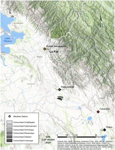
This research was carried out in two municipalities in Bolivia’s La Paz Department – Umala in the Central Altiplano and Ancoraimes in the Northern Altiplano near Lake Titicaca (see ). Both are home to indigenous Aymara farmers. Here we present results of a collaboration between their communities and UMSA that began in 2006 and continues to this day. The municipalities themselves have been described at length in previous research (Taboada et al., Citation2017; Valdivia et al., Citation2010).
Figure 1. Map of study area.
Both municipalities have a semi-arid climate, but annual rainfall is higher in the north. The Northern Altiplano communities have annual precipitation around 400 mm while the Central Altiplano communities receive between 300 and 350 mm per year. Both areas experience high levels of frost and hail risk and periodic droughts.
This research synthesizes results of undergraduate and graduate research carried out in three communities in each municipality between 2010 and 2015 under the supervision of UMSA faculty: Iñacamaya, Sabilani, and Incamaya in Umala and Chojñapata, Calahuancane, and Cohani in Ancoraimes. The study communities are located between 3700 and 4200 metres above sea level. They are all located 1-2 hours by highway from the major cities of El Alto and La Paz and have been economically linked to these population centres since road expansion in the 1990s.
Indigenous communities in Bolivia have a recognized legal status and considerable autonomy. Leaders are elected for annual terms of office and most decisions are made by majority votes of community wide meetings. Communities control access to their territories. Outsiders, including researchers and extension workers cannot work with community members without community authorization.
The Central Altiplano sites are relatively flat and have lower population densities than those of the Northern Altiplano. Central Altiplano elevations average 3700 metres and agroecological conditions are similar in the three study communities where the principal crops are potatoes, quinoa, fava beans, and alfalfa. Commercial dairy farming is an important activity, where there is access to ground water for irrigating alfalfa. The average area cultivated per family varies between 0.9 and 2.6 hectares, depending on the community (Valdivia et al., Citation2010). Flooding can be a risk because of the flat topography of these communities. The Northern Altiplano has more varied topography and cropping systems. Its communities are in a watershed draining into Lake Titicaca with one community, Chojñapata (4200 metres), at the top of the watershed and the other two, Calahuancane and Cohani near each other in the middle of the watershed between 3800 and 3900 metres. In addition to higher rainfall, temperatures are moderated by proximity to the lake. Because of altitudinal, topographical, and soil differences, the three communities occupy distinct agroecological niches. While all grow potatoes for subsistence needs, the area near the lake produces onions in large quantities, the middle community grows peas, while the highest produces more livestock and traditional potato varieties. Farm sizes are much smaller than in Umala with available crop land varying from 0.1 to 0.4 hectares (see ). Non-farm activities such as temporary or seasonal employment in nearby cities and handicraft production contribute significantly to most families’ incomes in Ancoraimes due to limited landholdings. Farming systems have changed significantly over the past 30 years in response to warming climate and improved market access. Traditional more rustic potato varieties have been replaced by the Waycha variety preferred by urban consumers and commercial vegetable production (onions and peas) has become important in Ancoraimes and commercial dairy production in Umala (Taboada et al., Citation2014, Citation2017)
From 2000-2010, both areas witnessed a decline in the use of traditional weather forecasting methods. At the turn of the twenty-first century more than 90% of producers used local forecast indicators for agricultural planning, but by 2009–2010 only 37% did in Umala and less than 10% in Ancoraimes (Yucra et al., Citation2019). Most farmers could still identify forecast indicators were but did not observe them. The decline in use was partly due to the death of local forecast experts; by 2010, there were three remaining in Umala and four in Ancoraimes – all but one was over 70 years old (Quispe, Citation2015). Traditional forecasting, like its meteorological counterpart, is complex and probabilistic. Local experts observe multiple indicators and need to observe the indicator species in several locations in a community to make accurate forecasts. Traditionally farmers have consulted with local experts to help them convert their own observations into forecasts. In addition to having more forecast knowledge and expertise, local experts act as channels for the flow of information between farmers in their community. They provide farmers with their expertise as well to information collected by their neighbours. In Ancoraimes traditional forecasting had almost disappeared and in Umala, producers were debating the validity of these indicators. Many in Umala argued that climate change and changes in production systems invalidated local indicators (Gilles et al., Citation2014). Neither area used forecasts produced by the national weather service. Farmers who did not use forecasts simply repeated the practices of the previous season and modified them according to the availability of labour and other inputs. Nonetheless, farmers in both regions, like farmers elsewhere, are interested in receiving accurate weather forecasts (Ouédraogo et al., Citation2018). The goal of UMSA’s collaboration with these communities has been to evaluate the forecast tools available to them.
4. Methods
Since Aymara communities have the legal right to exclude researchers and extension workers from their territories, long-term research projects require strong collaboration. In the case of the current project, UMSA had to receive approval by a vote of community members in an open meeting before it could begin working with farmers. The agreements between each community and UMSA is reviewed annually by all participating communities. Project results are presented to community meetings annually and at these meetings communities may request modifications of research activities or ask the university to provide technical assistance in areas not directly related to climate-related risk.
4.1. Identification of forecast indicators
Before the 2010–2011 growing season, community leaders in each of the six communities were asked to convene a meeting on traditional weather forecasting methods. In addition, they were asked to identify and issue a special invitation to those who were most knowledgeable about the subject. These meetings were organized as participatory workshops. Researchers showed participants pictures of forecast indicators previously identified by local forecast experts in the Umala and Ancoraimes (Gilles & Valdivia, Citation2009; Valdivia et al., Citation2010). They were asked if they recognized the indicators, if they knew the indicators’ names (in Spanish or Aymara), and if they knew what the indicators were used for. If they recognized an indicator and knew its use, they were asked when and where in the community these were observed. Responses were aggregated by community. There was considerable agreement across communities within each municipality (see ).
Table 1. Families participating in workshops and interviews.
4.2. Producer evaluation of indicators
The next step was to conduct a survey of a random sample of families to understand the knowledge of indicators and perceptions of their reliability. These surveys were carried out in 2011 and 2012 by UMSA students and were structured interviews that were analyzed using descriptive statistics. The number of completed interviews in each community is found in . Farmers who did not know any indicators or who lived most of the year outside of the community were excluded. We asked respondents to evaluate the reliability of each of the indicators that they knew of by giving them a score of one two or three (see and ). They were also asked if they had used an indicator to plan their agricultural activities. We did not ask about current use because previous surveys showed that use had declined rapidly and that less than 10% of the population in many communities used local forecast indicators. Results were presented at community wide meetings.
Table 2. UMALA, Central Altiplano Producer evaluation of the reliability of biological forecast indicators.
Table 3. ANCORAIMES, Northern Altiplano Producer evaluation of the reliability of forecast indicators.
4.3. Indicator validation using meteorological data
Finally, compared some indicators deemed most reliable by farmers in each municipality with meteorological data from stations we placed in the communities and from nearby weather stations with good historical data. The goal was to understand the physical basis for the behaviour of indicators and to examine the skill of forecasts based on them. For seasonal forecasts, we used historical records of annual rainfall for the four weather stations nearest to our study sites. For shorter-term forecasts, we used ten-day average temperatures and precipitation over a three-year period (2009–2012) from nearby stations – the closest being 25 km away.
We limited our comparisons to plant and geophysical indicators because after meeting multiple times with producers we could not devise a reliable way to observe and correlate animal behaviour. It was difficult to standardize observations of animal behaviours. Animals were not always present or observable in sufficient numbers and there was not agreement across our study communities on how to observe animal behaviours. Animal indicators were less tied to specific dates making it harder to standardize as well. In the case of plant and abiotic indicators, the same characteristics were consistently observed in all study communities.
For comparison purposes, we concentrated on the forecasts that were most actionable: those used to enhance production or reduce vulnerability to weather-related risks. The most actionable forecast indicators predicted conditions for the next growing season and forecasted the onset of reliable rains. Growing season forecasts help farmers decide where and what to plant and how much to invest in inputs. In wet years, less is invested in flood-prone areas but in dry years, flood-prone areas are more likely to produce reliable crops. Forecasts of the onset of steady rains enable farmers to choose the best dates to plant. Forecasts of severe weather events, such as hail and damaging frosts, are less actionable because crops are already growing, are vulnerable to these events, and there are few strategies available to mitigate their impacts. We used data from nearby weather stations to examine the indicators’ performance. For seasonal forecasts, we used 30 + years of annual precipitation data from four weather stations. In the case of forecasts for planting times, we used 10-day running averages of temperatures and precipitation for three calendar years.
5. Results
5.1. Participatory identification and evaluation of indicators
Farmers in the Central Altiplano identified 13 natural forecast indicators, nine of which were biotic and the rest abiotic. These indicators, and farmers’ evaluations of them, are found in . Producers in the Northern Altiplano identified twenty natural forecast indicators: 15 biotic and five abiotic. Environmental conditions in the Northern Altiplano are not as homogeneous as in the Central Altiplano, and the presence of forecast indicators is influenced by proximity to Lake Titicaca and elevation (See Interestingly, two indicators in the Central Altiplano and eight indicators in the Northern Altiplano communities were understood but not currently used by the people we interviewed.
The primary use of plant indicators is to determine when to plant potatoes – the staple food crop. However, some species observed in late spring or early summer to predict crop yields. Potatoes are planted between mid-October and early December. The optimal time for planting potatoes is determined by observation of soil conditions and forecasts of the onset of steady rains. If rains come earlier than normal, mid-October plantings will have the best yields because the crops will be less vulnerable to frosts at crucial points in the potato development cycle. However, if rains do not come early, early seeded crops must be replanted at significant cost to farmers. With normal rains, potatoes are planted in late October and early November. If rains come late, the best times to plant are late November or early December. There are tradeoffs between the risks presented by drought and those presented by frost. The later potatoes are planted, the greater the likelihood of adequate rains to promote plant growth but later plantings have a higher risk of damaging frosts.
All the plant species used to predict the onset of rains flower up to three times in early to mid-spring (August-October). Their flowering patterns indicate when it is optimal to plant. Just as there are three possible planting dates, indicator plants produce flowers three times. Successful flowering of these species indicates optimal planting times. If the first flowering is damaged by frost or severe weather, farmers know they shouldn’t plant early. If they are not damaged, farmers can plant early. The second planting date is associated with the second flowering of indicator species and the third planting with the last flowering. Only two plant species were identified as being very reliable – one in each municipality: Thola (Parastrephia lepidophylla) in the Central Altiplano and Sank’ayu (Lobivia caespietosa J. Porpus) in the Northern Altiplano.
Animal indicators are usually used to make seasonal forecasts of rain or crop production. The vocalizations of foxes were rated as the most reliable indicator in both study areas followed by the nesting behaviour of certain bird species. In the case of birds, farmers observe the location of nests, their geographical orientation, and their height. For some species, they observe the colour of eggs, as well. Birds were not seen as highly reliable indicators, although the liki liki (Andean plover) was an indicator in both the Northern and Central Altiplano.
Other indicators included winds, constellations, and the presence of moisture under rocks in the pre-dawn hours of Fiesta de San Juan (Saint John’s Day) on June 24th. Strong winds from specific directions predict hail and frost events. These indicators are seen as very reliable but generally precede these events by only a few hours, leaving virtually no time for mitigation activities. The appearance and/or scintillations of constellations were seen as moderately reliable indicators. The Pleiades constellation, which is observed on June 24th, was viewed as moderately reliable in the Northern Altiplano while the Southern Cross was a reliable indicator in the North but less so in the Central region. The other indicator present in both areas was the presence of moisture under rocks in the pre-dawn hours of Fiesta de San Juan. This day is close to the winter solstice and traditionally regarded as the coldest of the year. If there is moisture under rocks, the following growing season will be rainy; if there is not, the year is supposed to be dry. Farmers evaluated this indicator as moderately reliable in both the Northern and Central Altiplano regions. In the Central Altiplano, local experts in weather forecasting rated this indicator higher than our sample of farmers.
The next step in our analysis was to validate the reliability of selected local indicators using available meteorological data. We focused on indicators that had been used by most of respondents at some point in time. In the Central Altiplano there were two biotic and two abiotic indicators: two plant species, thola (Parastrephia lepidophylla) and phuscalla (Opuntia boliviana Salm-Dick), winds and moisture under rocks on San Juan Day. In the Northern Altiplano, two biotic indicators were present: foxes and a plant, sank’ayu (Lobivia caespietosa J. Porpus). This analysis required a basic understanding of the relationship between the expression of local forecast indicators and atmospheric conditions. As mentioned previously, we were unable to identify these relationships for animals. The relationship between plant indicators and atmospheric conditions was clearer; their flowering patterns were influenced by freezing temperatures and extreme weather events. The most common cause of failure to flower is sustained freezing temperatures. Temperature data was available from two weather stations located near our study communities, so we evaluated our plant indicators using this data.
We were interested in evaluating at least one seasonal forecast indicator. Orlove studied stars in Southern Peru and in the Northern and Central Altiplano (Orlove et al., Citation2000, Citation2002), so we chose another forecast indicator. We evaluated the presence of water under rocks during pre-dawn hours of Fiesta de San Juan. This indicator is used in both regions, and we understand the physical relationship between condensed moisture and atmospheric conditions. The presence of moisture under rocks is a function of minimum temperatures: the more moisture present, the higher the minimum temperature. The physical processes determining moisture are related to the amount of energy stored in water vapour around the winter solstice. The energy spent in condensation is released as heat, which, in turn, moderates minimum temperatures. While relative humidity would be a better indicator, reliable historical humidity data was not available. We first looked at seven years’ data from two weather stations that we had placed in our study communities to describe the relationship between annual rainfall and minimum temperature. These results looked promising, so we obtained temperature and precipitation data for the years 1980 to 2015 from El Alto, Patacamaya, and Copacabana and for the years 1980 to 2010 from Cotacota (see ).
5.2. Validation of planting time indicators using meteorological data
To examine plant indicators, we looked at ten-day average minimum temperatures and accumulated rainfall for 2009, 2010, and 2011 obtained from weather stations in Patacamaya (Central Altiplano) and Ancoraimes (Northern Altiplano) (see ). We were interested in the relationship between severe frosts and the appearance of reliable rains a few weeks after the frost occurrence.
The relationship between frost occurrence and consequent (around 30 days after) ten-day rainfall received in two stations agreed with local farmers’ observations of the ‘burning’ of wildflowers due to frost. In , the green indicates extreme minimum temperatures and is presented for each of the observation periods grouped in ten-day segments, while orange indicates the periods when there was significant rainfall after a frost.
Figure 2. Relationship between frosts and subsequent rainfall in the Central Altiplano.
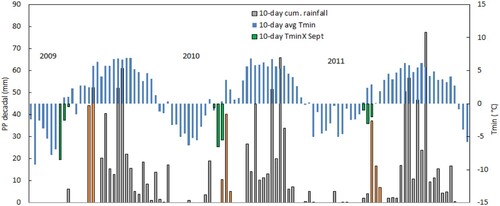
In Patacamaya, in 2009, the first two ten-day Tmin averages were very low, and all flowers (indicators) would have been killed, while the third ten-day period had little frost, corresponding to a late start to the rainy season. In 2010, only the first ten days had mild temperatures, while the second and third decades were very ‘frosty’. Correspondingly, there was a short early rainy period, followed by a dry period that lasted about a month. In 2011, frosts in the first observation period were mild and, about 20 days later, a concentrated period of rains occurred, followed by very scarce and low rains.
In Ancoraimes, in 2010, the first ten-day Tmin was very high, not having faced a frost event, but the following 10-day Tmin, was quite low. Early rains were followed by more than a month without rainfall. In 2011, all Tmins during the observation periods were very low. Early rains were slow and there was not a well-defined start of the rainy season. So, in both municipios, frosts were followed by periods without rain ( and ).
Figure 3. Relationship between frosts and subsequent rainfall in Northern Altiplano.
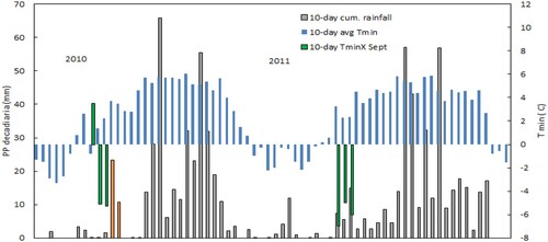
Figure 4. Relationship between the minimum temperature on Fiesta de San Juan and total precipitation for four stations in the Northern and Central Altiplano 1980–2015.
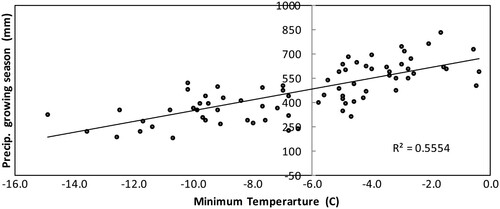
5.3. Meteorological validation of Fiesta de San Juan indicator
Our analysis of the relationship between pre-dawn temperatures on Fiesta de San Juan and annual rainfall was quite straightforward. We plotted the relationship between minimum temperatures on June 24th and annual precipitation for the four weather stations with historical precipitation data and calculated a correlation coefficient and an R2. The relationship was quite strong. There was a correlation of .775 between the amount of precipitation on June 24th and seasonal rainfall. So, knowing the minimum temperature on June 24th can predict 55.5% of the annual rainfall variation.
6. Discussion and conclusions
Evaluations of local forecast knowledge are not common in the Andean Highlands because the probabilistic and iterative nature of forecasting requires multiple years of local and meteorological data. This study represents one of the few efforts to validate local forecast knowledge based on both the producer perceptions (local knowledge) and multiple years of meteorological data. Lack of this kind of research has impeded the acceptance of local knowledge by governments and national climate services. Our investigation of seasonal forecasts and forecasts for the onset of reliable rains shows that they have a high degree of skill. This is good news given the fact that the number of meteorological stations in the region is insufficient to address the heterogeneity of mountain landscapes and create accurate agricultural forecasts.
The findings of this research surprised many community members and enhanced the status of local knowledge and of local forecast experts. Since this research was reported to the communities, forecast groups have been created where local experts, farmers and university scientists meet in the Fall to discuss forecasts (both local and meteorological). They meet again in the Spring to evaluate the skill of the Fall forecasts. Group members now also share forecast information on their phones to their neighbours using WhatsApp.
Results show the high potential for co-production of forecasts using both meteorological and local knowledge and managing climate-related risks in the region. In this case, use of meteorological data supported local knowledge and did not undermine it. Good seasonal forecasts provide farmers with information they need to decide what and where to plant and can guide input purchasing decisions. Forecasting the beginning of sustained rains can help farmers maximize yields and avoid losses caused by frosts or the late arrival of sustained rains. Application of local knowledge can help farmers reduce risk.
In addition, local knowledge can serve as a basis for expanding scientific knowledge. For example, the high correlation between minimum temperatures on June 24th suggests that there exists a heretofore unidentified teleconnection between conditions around the southern winter solstice and rainfall patterns in January and February. This connection has not yet been well studied, but Lupo et al. (Citation2017) have noted a change in jet stream patterns around these dates and Rojas-Murillo (Citation2019) has explored this relationship with interesting results. This fact provides an opportunity to better understand weather patterns in the Southern Hemisphere.
Even though the validity and skill of some forecast indicators have been established, local weather knowledge is still declining in use. Some farmers still doubt that local knowledge, developed in an era of subsistence agriculture and more stable environmental conditions, is still valid – and if it will be in the future. In addition, a turn from subsistence agricultural production systems to those in which farmers depend on commercial sales or off-farm income sources involves a deskilling of agricultural production (Stone, Citation2007, Citation2016) and one of the casualties is local knowledge. Spaces for the transmission of local knowledge are reduced by school attendance, off-farm employment, and market involvement (Gilles et al., Citation2014). Co-production of forecast knowledge can contribute to the preservation of local knowledge by giving it more legitimacy to technically trained people in government and international development agencies. However, even in a place like Bolivia, where the conservation and respect of local knowledge are mandated in the constitution, few resources are available to support co-production of forecasts. The weather service is currently under-resourced and depends heavily on external funding sources linked to global climate modelling efforts. Although local knowledge and co-production of climate knowledge are cited in global forums, they have not received significant funding from the international meteorological community. We hope that articles like these will help create a more favourable funding environment for the co-production of forecasts.
While this research showed that local seasonal forecasts and those related to the onset of rains were superior to those currently provided by climate services. There is one area where our research identified there was a lack of adequate local forecast tools – the area of short-term forecasts. The only reliable local indicators of frosts and winds could only predict events a few hours in advance – often too late to implement mitigation strategies. Two types of short-term forecasts would reduce the vulnerability of Altiplano producers. Forecasting the likelihood of frosts a few days in advance would facilitate the harvest of crops and the freeze drying of potatoes and the forecasting of uncommon precipitation events in late fall would reduce post-harvest damage. In other words, using traditional forecast methods for seasonal forecasts and for predicting the arrival of rains and using meteorological forecasts for short term forecasting (no more than 4–5 days) could reduce the vulnerability of small indigenous farmers in Bolivia’s Altiplano.
Disclosure statement
No potential conflict of interest was reported by the author(s).
Data availability statement
Historical meteorological data used is available from SEHNAMI (Bolivian national weather service) at http://senamhi.gob.bo/index.php/inicio; human subject data is subject to confidentiality agreements but those interested may contact Edwin Yucra at [email protected].
Additional information
Funding
Notes on contributors
Jere L. Gilles
Jere Gilles is currently an Associate Professor Emeritus and Assistant Director for International Engagement in the Division of Applied Social Sciences University of Missouri and a Lecturer in CIDES-Universidad Mayor de San Andres. His research focus is the co-production of agricultural and natural resource management knowledge and transdisciplinary research.
Magali García
Magali Garcia is currently a researcher and professor in the Faculty of Engineering of the Universidad Mayor de San Andres and is a member of the Independent Science for Development Council for the CGIAR system. Her areas of research are agro and bio-climatology and the sustainable management of soils, both related to indigenous knowledge and co-creation of sustainable management paradigms.
Edwin S. Yucra
Edwin Yucra is a lecturer in the Faculty of Agronomy and formerly was a research scientist in CIDES, Universidad Mayor de San Andres. His areas of interest are participatory research and extension. local knowledge systems and agricultural innovation.
Rogelio Quispe
Rogelio Quispe is an independent consultant and formerly was a lecturer in the Faculty of Agronomy, and a research assistant in CIDES, Universidad Mayor de San Andres His current interests are appropriate agricultural technology and management of climate relate risks.
Aymara Poma
Aymara Poma is a research assistant in the Faculty of Engineering, Universidad Mayor de San Andres and is a graduate student in the Universidad Publica del Alto and was a research assistant in CIDES, Universidad Mayor de San Andres.
Janneth M. Quispe
Janneth M. Quispe an independent consultant and was formerly a research assistant in CIDES, Universidad Mayor de San Andres. Her interests are in sustainable agricultural development and digital extension programs.
Katherine Rojas
Katherine Rojas is a graduate student in Atmospheric Sciences at the University of Missouri.
Pablo Cabrera
Pablo F. Cabrera is an independent consultant in Geography Information Systems focused on participatory research in agroecology and resource conservation.
References
- Archaya, S. (2011). Presage biology: Lessons from nature in weather forecasting. Indian Journal of Traditional Knowledge, 10(1), 114–124.
- Balay-As, M., Marlowe, J., & Gaillard, J. C. (2018). Deconstructing the binary between indigenous and scientific knowledge in disaster risk reduction: Approaches to high impact weather hazards. International Journal of Disaster Risk Reduction, 30, 18–24. https://doi.org/10.1016/j.ijdrr.2018.03.013
- Bohensky Erin, L., & Maru, Y. (2011). Indigenous knowledge, science, and resilience: What have we learned from a Decade of International Literature on “Integration”? Ecology and Society, 16.
- Bright, C., Mike, J. T., Innocent, N., & Washington, R. N. (2013). Useful traditional knowledge indicators for drought forecasting in the mzingwane catchment area of Zimbabwe. Disaster Prevention and Management, 22(4), 312–325. https://doi.org/10.1108/DPM-10-2012-0109
- Brodt, S. (2001). A systems perspective on the conservation and erosion of indigenous Agricultural Knowledge in central India. Human Ecology, 29(1), 99–120. https://doi.org/10.1023/a:1007147806213
- Chambers, R., Pacey, A., & Thrupp, L. A. (1989). Farmer first: Farmer innovation and agricultural research. The Bootstrap Press, 218.
- Daly, M., & Dilling, L. (2019). The politics of “usable” knowledge: Examining the development of climate services in Tanzania. Climatic Change, 157(1), 61–80. doi:10.1007/s10584-019-02510-w
- Daza, G. S., & Piñero, F. J. (2012). Bolivia: The construction of an alternative science and technology policy. Perspectives on Global Development & Technology, 11(3), 414–434. doi:10.1163/156914912X651578
- Ebhuoma, E. E., & Simatele, D. M. (2019). ‘We know our terrain’: Indigenous knowledge preferred to scientific systems of weather forecasting in the Delta State of Nigeria. Climate and Development, 11(2), 112–123. https://doi.org/10.1080/17565529.2017.1374239
- Fernández-Llamazares, Á, Díaz-Reviriego, I., Luz, A. C., Cabeza, M., Pyhälä, A., & Reyes-García, V. (2015). Rapid ecosystem change challenges the adaptive capacity of local environmental knowledge. Global Environmental Change, 31, 272–284. https://doi.org/10.1016/j.gloenvcha.2015.02.001
- Garriot, E. B. (1903). Weather Folklore and Local Weather Signs. USDA, Weather Bureau, Ed. Government Printing Office, 154, pp .
- Gilles, J. L., & Valdivia, C. (2009). Local forecast communication in the Altiplano. Bulletin of the American Meteorological Society, 90(1), 85–91. https://doi.org/10.1175/2008bams2183.1
- Gilles, J. L., Yucra, E., García, M., Quispe, R., Yana, G., & Fernandez, H. (2014). Factores de perdida de conocimientos de uso de los indicadores climáticos locales en comunidades del Altiplano Norte y Central. Revista de Investigación e Innovación Agropecuaria y de Recursos Naturales, 2(1), 7–15.
- Girard, N. (2015). Knowledge at the boundary between science and society: A review of the use of farmers’ knowledge in agricultural development. Journal of Knowledge Management, 19(5), 949–967. https://doi.org/10.1108/JKM-02-2015-0049
- González-Zeas, D., Erazo, B., Lloret, P., De Bièvre, B., Steinschneider, S., & Dangles, O. (2019). Linking global climate change to local water availability: Limitations and prospects for a tropical mountain watershed. Science of The Total Environment, 650, 2577–2586. https://doi.org/10.1016/j.scitotenv.2018.09.309
- Gómez-Baggethun, E. (2021). Is there a future for indigenous and local knowledge? The Journal of Peasant Studies, 48(1), 1–19. https://doi.org/10.1080/03066150.2021.1926994
- Gugulethu, Z., Stigter, N. K., & Walker, S. (2013). Use of traditional weather/climate knowledge by farmers in the South-Western Free State of South Africa: Agrometeorological learning by scientists. Atmosphere, 4(4), 383–410. https://doi.org/10.3390/atmos4040383
- Gwenzi, J., Mashonjowa, E., Mafongoya, P. L., Rwasoka, D. T., & Stigter, K. (2016). The use of indigenous knowledge systems for short- and long-range rainfall prediction and farmers’ perceptions of science-based seasonal forecasts in Zimbabwe. International Journal of Climate Change Strategies & Management, 8(3), 440–462. https://doi.org/10.1108/IJCCSM-03-2015-0032
- Hamacher, D. W., Barsa, J., Passi, S., & Tapim, A. (2019). Indigenous use of stellar scintillation to predict weather and seasonal change. Proceedings of the Royal Society of Victoria, 131(1), 24–33. https://doi.org/10.1071/RS19003
- Iticha, B., & Husen, A. (2019). Adaptation to climate change using indigenous weather forecasting systems in Borana pastoralists of southern Ethiopia. Climate and Development, 11(7), 564–573. https://doi.org/10.1080/17565529.2018.1507896
- Kieslinger, J., Pohle, P., Buitrón, V., & Peters, T. (2019). Encounters between experiences and measurements: The role of local knowledge in climate change research. Mountain Research & Development, 39(2), R55–R68. https://doi.org/10.1659/MRD-JOURNAL-D-18-00063.1
- Klein, J. A., Hopping, K. A., Yeh, E. T., Nyima, Y., Boone, R. B., & Galvin, K. A. (2014). Unexpected climate impacts on the Tibetan Plateau: Local and scientific knowledge in findings of delayed summer. Global Environmental Change, 28, 141–152. https://doi.org/10.1016/j.gloenvcha.2014.03.007
- Klenk, N., Fiume, A., Meehan, K., & Gibbes, C. (2017). Local knowledge in climate adaptation research: Moving knowledge frameworks from extraction to co-production. WIRES Climate Change, 8(5), 1–15. https://doi.org/10.1002/wcc.475
- Kloppenburg, J. (1991). Social theory and the de/reconstruction of agricultural science: Local knowledge for an alternative agriculture. Rural Sociology, 56(4), 519–548. https://doi.org/10.1111/j.1549-0831.1991.tb00445.x
- Latulippe, N., & Klenk, N. (2020). Making room and moving over: Knowledge co-production, indigenous knowledge sovereignty and the politics of global environmental change decision-making. Current Opinion in Environmental Sustainability, 42, 7–14. https://doi.org/10.1016/j.cosust.2019.10010
- López, S., Jung, J.-K., & López, M. F. (2017). A hybrid-epistemological approach to climate change research: Linking scientific and smallholder knowledge systems in the Ecuadorian Andes. Anthropocene, 17, 30–45. https://doi.org/10.1016/j.ancene.2017.01.001
- Lupo, A. R., Garcia, M., Gilles, J., & Rojas, K. (2017). ENSO related seasonal rain prediction over South America. 2nd Annual International Conference on Atmospheric Science, MDPI. https://doi.org/10.3390/ecas2017-04140.
- Malsale, P., Sanau, N., Tofaeono, T. I., Kavisi, Z., Willy, A., Mitiepo, R., Lui, S., Chambers, L. E., & Plotz, R. D. (2018). Protocols and partnerships for engaging Pacific Island communities in the collection and use of traditional climate knowledge: Traditional weather and climate knowledge remains important for environmental decision-making in the Pacific. Bulletin of the American Meteorological Society, 2471, 2471–2489. https://doi.org/10.1175/BAMS-D-17-0163.1
- Nadasdy, P. (1999). The Politics of TEK: Power and the “integration” of knowledge. Arctic Anthropology, 36(1/2), 1–18.
- Naess, L. O. (2013). The role of local knowledge in adaptation to climate change. WIREs: Climate Change, 4(2), 99–106. https://doi.org/10.1002/wcc.204
- Nalau, J., Becken, S., Schliephack, J., Parsons, M., Brown, C., & Mackey, B. (2018). The role of indigenous and traditional knowledge in ecosystem-based adaptation: A review of the literature and case studies from the Pacific Islands. Weather, Climate, and Society, 10(4), 851–865. https://doi.org/10.1175/WCAS-D-18-0032.1
- Nkuba, M. R., Chanda, R., & Mmopelwa, G. (2020). Indigenous knowledge systems and indicators of rain: Evidence from the Rwenzori region, Western Uganda. Weather, Climate, and Society, 12(2), 213–234. https://doi.org/10.1175/WCAS-D-19-0027.1
- Nyadzi, E., Werners, S. E., Biesbroek, R., & Ludwig, F. (2021). Techniques and skills of indigenous weather and seasonal climate forecast in Northern Ghana. Climate and Development, 13(6), 551–562. https://doi.org/10.1080/17565529.2020.1831429
- Okonya, J. S., & Kroschel, J. (2013). Indigenous knowledge of seasonal weather forecasting: A case study in six regions of Uganda. Agricultural Sciences, 4(12), 641–648. http://doi.org/10.4236/as.2013.412086
- Orlove, B. S., Chiang, J. C. H., & Cane, M. A. (2000). Forecasting Andean rainfall and crop yield from the influence of El Niño on Pleiades visibility. Nature, 403(6765), 68–71. https://doi.org/10.1038/47456
- Orlove, B. S., Chiang, J. C. H., & Cane, M. A. (2002). Ethnoclimatology in the Andes: A cross-disciplinary study uncovers a scientific basis for the scheme Andean potato farmers traditionally use to predict the coming rains. American Scientist, 90(5), 428–433. https://doi.org/10.1511/2002.33.791
- Orlove, B. S., Roncoli, C., Kabugo, M., & Majugu, A. (2010). Indigenous climate knowledge in southern Uganda: The multiple components of a dynamic regional system. Climatic Change, 100(2), 243–265. https://doi.org/10.1007/s10584-009-9586-2
- Ouédraogo, M., Barry, S., Zougmoré, R. B., Partey, S. T., Somé, L., & Baki, G. (2018). Farmers’ willingness to pay for climate information services: Evidence from cowpea and sesame producers in Northern Burkina Faso. Sustainability, 10(3), 611. https://doi.org/10.3390/su20030611
- Patt, A., & Gwata, C. (2002). Effective seasonal climate forecast applications: Examining constraints for subsistence farmers in Zimbabwe. Global Environmental Change, 12(3), 185–195. https://doi.org/10.1016/S0959-3780(02)00013-4
- Plotz, R. D., Chambers, L. E., & Finn, C. K. (2017). The best of both worlds: A decision-making framework for combining traditional and contemporary forecast systems. Journal of Applied Meteorology and Climatology, 56(8), 2377–2392. https://doi.org/10.1175/JAMC-D-17-0012.1
- Quispe, R. (2015). Validez y funcionamiento de indicadores climáticos naturales para la planificación agrícola en seis comunidades del altiplano norte y central [Tesis de maestría en medio ambiente y recursos naturales]. Escuela Militar de Ingeniería 156 pp.
- Radeny, M., Desalegn, A., Mubiru, D., Kyazze, F., Mahoo, H., Recha, J., Kimeli, P., & Solomon, D. (2019). Indigenous knowledge for seasonal weather and climate forecasting across East Africa. Climatic Change, 156(4), 509–526. https://doi.org/10.1007/s10584-019-02476-9
- Reyes-García, V., Fernández-Llamazares, Á, Guèze, M., Garcés, A., Mallo, M., Vila-Gómez, M., & Vilaseca, M. (2016). Local indicators of climate change: The potential contribution of local knowledge to climate research. Wiley Interdisciplinary Reviews: Climate Change, 7(1), 109–124. https://doi.org/10.1002/wcc.374
- Rojas-Murillo, K. (2019). ENSO and PDO related variability in seasonal range prediction for the Bolivian Altiplano region in South America [Master's thesis, School of Natural Resources, University of Missouri], 58pp., https://hdl.handle.net/10355/72283
- Roncoli, C., Ingram, K., & Kirshen, P. (2002). Reading the rains: Local knowledge and rainfall forecasting in Burkina Faso. Society & Natural Resources, 15(5), 409–427. https://doi.org/10.1080/08941920252866774
- Salite, D. (2019). Traditional prediction of drought under weather and climate uncertainty: Analyzing the challenges and opportunities for small-scale farmers in Gaza province, southern region of Mozambique. Natural Hazards, 96(3), 1289–1309. https://doi.org/10.1007/s11069-019-03613-4
- Sánchez-Cortés, M., & Chavero, E. L. (2011). Indigenous perception of changes in climate variability and its relationship with agriculture in a Zoque community of Chiapas, Mexico. Climatic Change, 107(3-4), 363–389. doi:10.1007/s10584-010-9972-9
- Sillitoe, P. (2010). Trust in development: Some implications of knowing in Indigenous knowledge. The Journal of the Royal Anthropological Institute, 16(1), 12–30. https://doi.org/10.1111/j.1467-9655.2009.01594x.
- Sillitoe, P., & Marzano, M. (2009). Future of indigenous knowledge research in development. Futures, 41(1), 13–23. https://doi.org/10.1016/j.futures.2008.07.004
- Stone, G. D. (2007). Agricultural deskilling and the spread of genetically modified cotton in warangal. Current Anthropology, 48(1), 67–103. https://doi.org/10.1086/508689
- Stone, G. D. (2016). Towards a general theory of Agricultural Knowledge production: Environmental, social, and didactic learning. Culture, Agriculture, Food & Environment, 38(1), 5–17. doi:10.1111/cuag.12061
- Taboada, C., Garcia, M., Gilles, J., Pozo, O., Yucra, E., & Rojas, K. (2017). Can warmer be better? Changing production systems in three Andean ecosystems in the face of environmental change. Journal of Arid Environments, 147, 144–154. https://doi.org/10.1016/j.jaridenv.2017.08.005
- Taboada, C., García, M., Cuiza, A., Pozo, O., Yucra, E., & Gilles, J. (2014). Estructuración económica de sistemas productivos agrícolas en respuesta a la variabilidad climática en los Andes Boliviano. Revista de Investigación e Innovación Agropecuaria y de Recursos Naturales, 1(1), 16–29.
- Tengö, M., Hill, R., Malmer, P., Raymond, C. M., Danielsen, F., Elmqvist, T., & Folke, C. (2017). Weaving knowledge systems in IPBES, CBD and beyond—lessons learned for sustainability. Current Opinion in Environmental Sustainability, 26-27, 17–25. https://doi.org/10.1016/j.cosust.2016.12.005
- Valdivia, C., Kengo, M., Jimenez, E., & Turin, C. (2015). Climate change, global drivers, and local decision makers in rural communities: The role of translational research and adaptation strategies that contribute to resilience. In H. S. J. James (Ed.), Ethical tensions from new technology: The case of agriculture biotechnology. CABI, 162–172.
- Valdivia, C., Seth, A., Gilles, J., García, M., Jiménez, E., Cusicanqui, J., Navia, F., & Yucra, E. (2010). Adapting to climate change in Andean ecosystems: Landscapes, capitals, and perceptions shaping rural livelihood strategies and linking knowledge systems. Annals of the Association of American Geographers, 100(4), 818–834. doi:10.1080/00045608.2010.500198
- Van Kessel, J., & Enriquez Salas, P. (2002). Señas y Señaleros de la Madre Tierra; Agronomía Andina. Abyala & IECTA, 309 pp.
- Vedeld, T., Hofstad, H., Mathur, M., Büker, P., & Stordal, F. (2020). Reaching out? Governing weather and climate services (WCS) for farmers. Environmental Science & Policy, 104, 208–216. https://doi.org/10.1016/j.envsci.2019.11.010
- Vedeld, T., Mathur, M., & Bharti, N. (2019). How can co-creation improve the engagement of farmers in weather and climate services (WCS) in India. Climate Services, 15, 100–103. https://doi.org/10.1016/j.cliser.2019.100103
- Weatherhead, E., Gearheard, S., & Barry, R. G. (2010). Changes in weather persistence: Insight from Inuit knowledge. Global Environmental Change, 20(3), 523–528. https://doi.org/10.1016/j.gloenvcha.2010.02.002
- Yucra, E., Gilles K, J., Garcia, R. M., Quispe, J., Alavi, G., Borda, A., & Aguilera, M. (2019). Integrando conocimientos locales y tecnológicos de pronóstico del clima como estrategia para apoyar la producción agrícola en el altiplano boliviano. In M. Garcia (Ed.), Ciencias en diálogo: Soluciones desde la práctica, El trabajo de la Universidad Mayor de San Andrés para Integrar Saberes. Universidad Mayor de San Andrés, 72–87.
- Zuma-Netshiukhwi, G., Stigter, K., & Walker, S. (2013). Use of traditional weather/climate knowledge by farmers in the South-Western Free State of South Africa: Agrometeorological learning by scientists. Atmosphere, 4(4), 383–410. https://doi.org/10.3390/atmos4040383