
ABSTRACT
In heritage management plans, maps have long been used to draw boundaries around regions and plot natural and cultural sites, trails and routes. Attention to participatory mapping and counter-mapping has increased alongside trends towards bottom-up approaches to heritage that recognise local communities as experts in their own heritage. This article reflects on participatory mapping activities undertaken on Norfolk Island, home to the UNESCO World Heritage listed Kingston and Arthur’s Vale Historic Area. Since the production of the first management plan in 1980, heritage management of Kingston has overwhelmingly privileged the preservation and interpretation of its convict heritage, with historically little attention paid to the island’s past Polynesian settlement and the ongoing Pitcairn settlement since 1856. The article presents findings from collaborative mapping exercises centred on routes, customary practices, and emotions undertaken with Pitcairn Settler descendants and others with long and deep connections to Norfolk Island. In particular, we focus on participants’ commentaries on Kingston’s heritage management. Our analysis highlights the importance of protecting heritage in ways that account for everyday and contemporary experiences, emotional resonances, and unbounded uses of this living heritage site.
Introduction
On Norfolk Island, the UNESCO World Heritage listed Kingston and Arthur’s Vale Historic Area – also known as Kingston, KAVHA or, in the local language, Daun’taun – is a significant living heritage site, with a rich, complex and tumultuous past and present. In a management context, living heritage refers to continuity of a core community
that created living heritage and sustains the original function of heritage, retains its original connection with it over time and still considers heritage an integral part of its contemporary life in terms of its identity, pride, self-esteem, structure, and well-being, has a strong sense of ownership/custodianship for heritage and sees the caring for heritage as its own inherent obligation.Footnote1
A living heritage approach to management places an emphasis on ‘the (intangible) connection of community with heritage rather than on the (tangible) fabric’.Footnote2 Kingston has been formally ‘managed as a historic site since 1982’,Footnote3 when conservation efforts in the West were guided by a materials-based approach to heritage management. At that time, systems were put in place in Kingston to ‘regulate and control’Footnote4 the site’s heritage through policies and plans aimed at conserving historic structures, encouraging tourism, re-establishing a museum and developing an interpretive strategy.Footnote5 Since the production of the first management plan in 1980, heritage management of Kingston has overwhelmingly privileged the preservation and interpretation of its convict heritage, with historically little attention paid to the island’s past Polynesian settlement and the ongoing Pitcairn settlement since 1856. On Norfolk Island, the Pitcairn Settler descendants constitute the core community of Kingston’s living heritage.
Like many places across the globe, heritage management on Norfolk Island has long been guided by an ‘authorised heritage discourse’Footnote6 that elevates tangible, built, Eurocentric heritage. Such discourses have underpinned the identification and preservation of historical sites, including through tools such as mapping, which ‘traditionally served as a visual device to locate, navigate, document, and delimit heritage places and their physical contexts’.Footnote7 Planning documents relating to conservation efforts in Kingston note that maps form an important part of ‘the historical record that contribute to KAVHA’s significance’.Footnote8 Alongside more recent critiques of authorised heritage discourses, however, has come alternative ways of understanding and using mapping. Beyond using maps to catalogue and organise space, maps can also be used as a tool for resistance, disrupting dominant perceptions of heritage places and amplifying other ways of seeing and relating to the world.
This article reflects on hands-on mapping activities undertaken with Pitcairn Settler descendants and others with long and deep connections to Norfolk Island. The purpose of these mapping activities was to capture relationships, memories, practices, routes, and emotions that are often intangible, ephemeral or undocumented in authorised heritage management and interpretation practices. The article begins by outlining relevant literature on counter-mapping and community mapping, with a particular focus on mapping in the context of heritage. We then provide an overview of the background to Norfolk Island, including the use of maps in KAVHA’s heritage management planning documents, and an outline of our project and its methods. The article presents findings from three different collaborative mapping exercises centred on routes, customary practices, and emotions. In particular, we focus on participants’ commentaries on Kingston’s heritage management before unpacking how the project’s mapping exercises compare to the first KAVHA Management Plan and more recent Site Master Plan in terms of our interest in living heritage. The article concludes with reflections on the importance of protecting heritage in ways that account for everyday and contemporary experiences, emotional resonances, and unbounded uses of living heritage spaces.
Participatory Mapping and Cartographies of Heritage
Maps are not neutral reflections of the world, but socially and politically constructed texts.Footnote9 They can simplify, conceal and distort the lived realities of place.Footnote10 Sletto describes how maps are embedded in power relations:
Maps … have unwritten indigenous occupations of places, shaped public opinion in times of crisis and war, and created expectations for the proper ordering of the social and the natural. Maps put things and people in their place. Not only do they order the material world and make us visualize the where, but through their rhetorical power they also simultaneously obscure the why. Most maps – especially ‘scientific’ maps produced by regional, state, and global institutions and their agents – are mute about the social context and consequences of their own existence.Footnote11
However, maps can also be created with the specific purpose of subverting the processes of production and representational politics associated with traditional or scientific maps, as evident in critical research on counter-mapping,Footnote12 sketch mappingFootnote13 and participatory mapping/cartography.Footnote14 Unsurprisingly, much of this work emerges from the field of geography.
Writing on participatory mapping in the context of Indigenous cartography and human rights lawsuits, Wainwright and Bryan suggest that such activities function to ‘rework’, rather than ‘reverse’ colonial logics.Footnote15 The authors argue that the focus on land as property ‘deepens capitalist social relations’, but can nonetheless address some important injustices.Footnote16 Beyond the legal context, alternative critical cartographies can offer a means through which ‘subjective spatial experiences’ and ‘place attachment’Footnote17 are recognised, especially when ‘the unseen, the concealed’ and the ‘[s]tories of the less privileged’Footnote18 are brought to the fore. For instance, Campos-Delgado, in her work on cognitive mapping and migration, argues that counter-mapping brings to light narratives and relations that are ‘veiled’ in traditional maps by putting marginalised subjects at the centre of the storytelling process.Footnote19 Kim categorises this kind of activity as ‘testimony mapping’ – the production of maps that ‘challenge our understanding of what is the status quo through re-presenting situations, often injustices or overlooked phenomena’.Footnote20
Mapping techniques are not new to heritage studies and practice.Footnote21 In heritage management plans, maps have long been used to draw boundaries around regions and plot natural and cultural sites, trails and routes. Attention to participatory mapping has increased alongside trends towards ‘bottom-up’ approaches to heritage that are ‘grounded in local concerns and interests’ and everyday life, and which recognise local communities as experts in their own heritage.Footnote22 In a comprehensive review of participatory mapping in archaeology, Álvarez Larrain and McCall note how the ‘heritage valued by archaeologists … may not coincide with the heritage valued by communities’.Footnote23 Harrison offers some examples of these conflicting values in his work on ‘Indigenous and non-Indigenous heritage management’Footnote24 in Australia:
The interpretation and management of Oxley Wild Rivers National Park as a world heritage wilderness area sought to stress the absence of human modification and history in the area. Instead, this process of mapping memories revealed the densely layered and complex histories of mustering in the gorge country. Similarly, at Dennawan, what we might have traditionally viewed as an abandoned archaeological site was re-animated as a place of contemporary pilgrimage and the active creation of a sense of community and identity in the present.Footnote25
Further to this, De Nardi suggests that ‘collaborative experiential mapping’ aids in representing places as ‘lived-in cultural landscape[s]’ rather than merely sites where fossils or artefacts are located.Footnote26 This task can be undertaken by, for example, capturing the ‘tangible, immaterial, invisible, human, spiritual and more-than-human entities, and their worlds that are at risk of erasure’ or that do not figure prominently in traditional heritage interpretation and management practices.Footnote27 As Harrison posits, these mapping practices and what they reveal go beyond merely representing intangible heritage, and can be regarded as an ‘“intervention” in mainstream heritage practices’.Footnote28 Used strategically, then, participatory mapping not only provides a means through which to document alternative cartographies and subaltern knowledges, but can foster new processes and resources that can be used for social cohesion and community building as well as activism, critique and justice.Footnote29
Background
Norfolk Island is a small island (35 square kilometres) situated in the South Pacific Ocean, approximately 1,500 kilometres off Australia’s east coast. Four distinct human settlements have been documented on Norfolk Island: a Polynesian settlement (c.1150–1450); a British agricultural settlement (1788–1814); a British penal settlement (1825–1855); and the Pitcairn settlement (1856–present). Of the Island’s current 2,200 residents, approximately a quarter identify as Pitcairn Settler descendants.Footnote30 This distinct cultural and language group are the descendants of a small group of Polynesian women (from the islands of Tahiti, Huahine and Tubuai) and British men (including mutineers of the HMS Bounty) who had founded a community on Pitcairn Island in 1790. In the early 1850s, Britain granted the Pitcairn Islanders occupancy of Norfolk Island. Pitcairn’s 194 residents arrived on Norfolk Island on 8 June 1856, now commemorated each year as ‘Bounty Day’.
The Pitcairners emigrated to Norfolk Island on the understanding that they would hold the land in common as the island’s only residents, having not been advised in advance that land distribution would be subject to the approval of the Governor of New South Wales nor that the landing site of Kingston would remain property of the Crown.Footnote31 In 1913, hopes for ongoing self-determination were eroded when Norfolk Island was designated an Australian External Territory by the Commonwealth of Australia. A degree of self-government was returned to Norfolk Islanders in 1979, with the associated legislation including a preamble recognising ‘the special relationship’ that Pitciarn descendants have to the Island and ‘their desire to preserve their traditions and culture’.Footnote32 Self-government was abolished by the Australian Government in 2015 following the passing of the Norfolk Island Legislation Amendment Bill, with the Legislative Assembly replaced by a regional council operating under the New South Wales Local Government Act.Footnote33 This sparked the establishment of a tent embassy in Kingston as a form of peaceful protest against Australia’s ongoing political interventions. Of particular concern recently has been the suspension and subsequent dismissal of the locally elected councillors, who were replaced by a federal government-appointed administrator. As a result of Australia’s political interference, Pitcairn descendants on Norfolk Island experience contemporary life as colonial subjects.Footnote34
Our article focuses on KAVHA, which was inscribed on the UNESCO World Heritage List in 2010 as one of 11 Australian Convict Sites. Beyond its many visible, built remnants of convict heritage, Kingston is also a vibrant living heritage place with a working port, private residences, sites of recreation, a church and an active cemetery. It is also the site for significant cultural practices and political activity. Much like Norfolk Island’s broader political struggles, its heritage interpretation and management have been a site of contention. Despite lasting longer than the British settlements, the Polynesian and Pitcairn settlements have historically been far less visible in KAVHA’s interpretation strategies.Footnote35 The changing political landscape has also impacted Norfolk Islanders’ role in the management of KAVHA. During the years of self-government (1979–2015), the board overseeing site management was constituted by two Commonwealth and two Norfolk Island members. This shared responsibility was removed following the abolishment of self-government, with the Commonwealth becoming solely responsible for heritage management.Footnote36 The Norfolk Island Council of Elders and Norfolk Island People for Democracy have noted that these ‘new management arrangements … dispossess or diminish the continuous usage, occupation and connection rights of the Norfolk people’ in relation to Kingston.Footnote37
Mapping has been central to heritage management in Kingston, particularly with the introduction of the inaugural KAVHA Management Plan of April 1980.Footnote38 The maps in the plan illustrate, for example, the existing landscape and structures, existing conservation projects, types of land tenure and land use, activities, a historical map from 1796, a policy plan with 14 demarcated areas, and concept maps of interpretive story elements. In later plans, the number and type of maps varied. The most recent Site Master Plan includes maps representing heritage boundaries; tenure types; existing site, building, landscape and precinct boundaries and uses; the Australian Convict Sites locations; island-wide vehicle circulation and site entry; vehicular circulation and parking analysis; pedestrian access and movement; and a series of maps of proposed changes and project implementation.Footnote39 Maps have clearly been integral to communicating the planning and management priorities for Kingston. However, as part of a system that prioritises ‘expert’ knowledge and ways of working (e.g. cataloguing, segmenting, assigning value), such maps reinforce the kinds of injustices detailed above, dislocating the core community from decisions about Kingston’s custodianship.
Methods
This article emerges from the Australian Research Council-funded project, ‘Reimagining Norfolk Island’s Kingston and Arthur’s Vale Historic Area’ (2021–2024). The project seeks to examine the role that KAVHA, as a living heritage site, plays in resisting or reinforcing cultural injustices. Cultural justice – with its focus on ‘issues of power, participation, access, representation and impact’Footnote40 – informs both the conceptual orientation and methodological approach of the project. The key data collection methods used in the project are interviews and arts-based workshops aimed at producing a series of zines.Footnote41
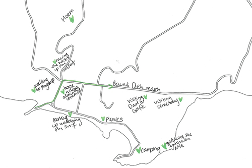
This article draws specifically on findings from three workshops, each of three hours duration and held across three consecutive days in September 2022, that focused on mapping the Kingston area. Our objective with these workshops was to invite participants to map sites of significance, practices, feelings and movements ‘from below’Footnote42 as an alternative to the official kinds of maps, tours and signage that originate ‘from above’, designed and distributed by groups such as heritage management authorities. The workshops were designed as ‘drop-in’ sessions where participants could contribute as little or as much as they pleased. Of the project’s 66 total participants, 27 were part of the mapping workshops, with 11 of those having previously been involved in other data collection activities for the research. Each workshop was structured around four activities using hard copies of a base map created by Zel – a tracing of the KAVHA boundary area, its key roads and the coastline. Three activities – on routes, customary practices, and emotions respectively – asked participants to contribute to large, collaboratively-produced maps, while one activity invited them to work on their own individual map.
To go beyond what could be represented visually, we recorded all of the conversations we had with participants. There were multiple recordings attached to the four activity stations as well as roaming digital recorders leading to a total of 31 hours of audio being captured. The recordings were time-stamped and partially transcribed by Chelsea with a focus on the moments where participants spoke in detail about their decisions on what to include on the maps, challenges experienced in articulating their relationship to Daun’taun, and reflections on the mapping activity. The timestamping document was then coded by the authors, noting specific themes that emerged from the mapping exercises relating to heritage management. Written components of the maps were transcribed and coded thematically, while visual representations such as stickers and drawings were categorised according to their location on the map.
Real names are used in this article in accordance with ethical clearances provided by the authors’ institutions and agreed to by participants in the project’s informant consent package. To work towards the decolonising of knowledge, our emphasis on ensuring participants are afforded ‘the right, the space, the voice “to tell [their] own stories from [their] own perspectives”’Footnote43 also involves preserving their use of the Norf’k language in the article, presenting it without translation. Norf’k is recognised by UNESCO as an endangered language and our use of translanguaging here is a form of linguistic decolonisation in knowledge production that respects a key component of the intangible cultural heritage of our participants. The language dictionaries of Alice Buffett and Beryl Nobbs-Palmer are recommended resources for translation if needed.Footnote44
Counter-Mapping Intangible, Ephemeral and Undocumented Heritage
Routes
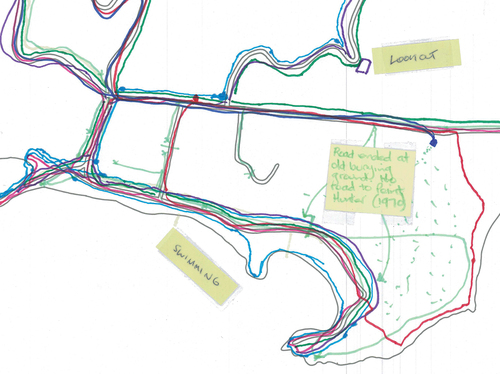
The prompt for the first activity was: ‘How do you move through Daun’taun? Draw your routes (driving, walking, biking, etc.)’. These could be past or present, or a combination. This activity revealed how participants go ‘off-road’ – they are not bound by the key thoroughfares included on the base map. For example, one participant included a regular route behind the structures of the CompoundFootnote45 and Gaol where no road or formal pathway exists (see ). Participants described how, over time, the ability to go off-road in Kingston has been disrupted by heritage management decisions. Eddie indicated that in the past the space ‘was open’ with ‘no fencing’ so ‘you could ride a horse, walk, ride a motorbike … all through’ Kingston without being confined by the official roads. George spoke about being able to drive across the Golf Course to Cemetery Beach because the Golf Course only had fences around the greens. As Eddie noted, ‘after the 1980s’ – a time when heritage management practices became more formalised in KAVHA – the freedom of movement became increasingly curtailed. Participants remarked on how the erection of fences and other restrictive materials have disrupted traditional routes through the site. Heidi observed that heritage management strategies had included ‘put[ting] the sandstone down the bottom of Middlegate [Road] and then those big logs up the top to stop people driving up there, and now there’s little bollards in that little valley down here’. Pointing to the map, Heidi continued, ‘people have ridden motorbikes and driven cars up there forever. But they’ve blocked it off to cars now’.
Figure 1. Detailed view of routes map showing an off-road vehicular route behind the compound and Gaol, the Bounty Street Bridge closure, and walking routes through the golf course.
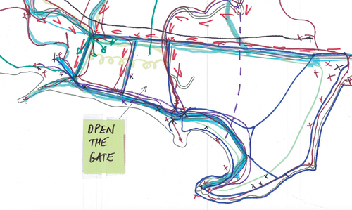
New fencing was still being erected at the time of our research, with Pat highlighting recent additions in the Watermill Valley: ‘as far as I know … that area has always been open, even when the convicts were here, it wasn’t segregated off … They’ve added [electric] fences … along the creek’. Kym noted that the proliferation of fencing in KAVHA ‘changes the track of exercising’. The imposed changes to movement through the site via fences, gates, boulders, logs, bollards or other forms of road closures as well as traffic measures like speed bumps impacted how participants felt about the site. Chris stated ‘I like unfettered access. I don’t like fences’ and added to the map a sticky note reading ‘open the gate’ in reference to the chain that blocks off vehicle access to the Compound (see ). Kym expressed ‘I can’t stand the fencing. The fencing along Lone Pine makes me angry because I don’t think, personally, that it needs to be there … I also don’t like … the barriers at Munnas’. Other participants expressed concern around where the next tranche of fencing might be rolled out:
[are they] going to put fences up to stop people driving on the grass in front of the Compound? You know how they put fences along in front of The Reef [to the east of Munnas]. I can see them doing the same thing at the Compound … I could just see something like that happening because there were never this many fences. (Heidi)
Figure 2. Detailed view of routes map depicting horse riding across the common, walking routes through the Golf Course, and a sticky note referring to a chain that is used to block vehicular entrance to the compound.
These comments reveal a sense of disenfranchisement and lack of agency when it comes to decision making processes in Kingston. Participants’ discussions also indicate a sense of being overwhelmed by rapid change that has altered how they are able to engage with the site now and into the future.
Participants also expressed a longing for the opening up of old routes, especially in relation to Bounty Street and the closure of the Bounty Street Bridge. Vehicular access to the bridge was blocked in early 2020 after a structural inspection determined the bridge was sinking.Footnote46 At the time of our mapping workshops, the route was closed to traffic indefinitely. Bounty Street was described by participants as having been a significant thoroughfare for movement between Quality Row and Bay Street. In the act of drawing their routes through the site on the base map, the location of the Bounty Street Bridge caused many participants to pause. One drew a line across the road to indicate its closure (see ). Mikiela reflected, ‘I really miss that road’. Kym stated, ‘I don’t like that we can’t use the bridge, that it’s still blocked off’. ‘This whole road – gone’, lamented Heidi. Some participants went on to ponder how the bridge’s closure and subsequent shift of all vehicular traffic to Pier Street could potentially pose future challenges to routes through Kingston. Tane noted that the diversion of all traffic to Pier Street might eventually have a negative impact on the structural soundness of the Pier Street Bridge. In doing so, Tane raised the question of what will happen to KAVHA as a living heritage site if all access roads to the water end up being closed to traffic.
Customary Practices
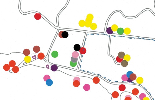
The second activity asked: ‘Where do traditional or customary practices take place?’ We invited participants to draw symbols that represented these practices onto stickers and attach those to the particular spots where the practice occurs. Regarding the impacts of heritage management on traditional use of Kingston, participants commented on restrictions on horse riding, agistment and racing. Ten participants mentioned the role horses played in the Pitcairner settlement up until living memory. Dids spoke about living ‘up country’ and needing to ‘catch my horse’ in order to travel to the beach down at Kingston. Once at the beach, he would ‘tie it there under the pines’. Dids also mentioned his role in mustering cattle on horseback Daun’taun and riding the racetrack at the Golf Course. Reflecting on past connections between Islanders, horses and Kingston, Dids described a sadness around the fencing of the Golf Course to remove the cattle – a decision which he connected to the stopping of races.
The change in use of horses due to management decisions in Kingston was spoken about most extensively by two participants in their 20s – Amy and Heidi – in reference to their childhood and early teen years. Heidi added a sticky note to the map writing ‘wi jes yuusa raid a horse orl thruu taun’ (see ). They made reference to horse riding in their individual maps (see ), added squiggly lines to represent their movement across the Common on horseback on the Routes map (see ), and, as with other participants, also placed horse symbol stickers in the Customary Practices map (see ). Heidi and Amy’s riding excursions in Kingston were hampered after a series of phone calls to the horse-riding club, including from the police. Pointing to the foreshore area on the map, they explained:
Figure 3. Detailed view of customary practices map showing symbols and sticky notes related to the presence of horses in Kingston.
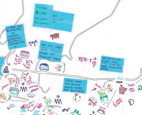
Figure 4. Detailed view of customary practices map showing a ‘parking up’ symbol at the top of the pier area.
Heidi: We weren’t really allowed to ride down around in here.
Chelsea: Did you know that?
Amy: No.
Heidi: No. We weren’t allowed to go over the cattlestops.
Amy: … We were allowed on Cemetery [Beach] and that was it. But you can’t really go on Cemetery [Beach with horses]. You can, but you can’t get in the water.
Heidi: It’s hard with horses because it’s all rocky. And we weren’t really allowed on the Golf Course. … We would have been really young when we got told we couldn’t come through here. Maybe 12 or 13. …
Amy: … if you’re allowed to walk your dog along there, I don’t know why you can’t walk your horse.
Here, Amy and Heidi describe the exclusion of horses from areas that our other participant, Dids, had mentioned as places he rode in the past – the Golf Course and Emily and Slaughter Bays. Horses are not technically excluded from Kingston in management plans, but riding for leisure is challenged by the erection of fencing along Watermill Valley, the Kingston Common and the common land of the Golf Course, as well as by cattle grids and the ‘policing’ of horses in the foreshore area.
Another customary practice participants referred to, and one they observed was under threat by heritage management, was ‘parking up’. This term was used to capture the parking of a car for the purpose of viewing an area, alone or in the company of others. Sharyn, for example, described the place known by locals as the ‘top of the pier’ as a key site for parking up (see ):
when my grandfather was alive – I still park up there now, like looking at the ship and you have to check out the new barges and the rest of it, and waiting for the ship and your own stuff to come off. … With the older generation, you would take them driving because they could no longer drive and it was really nice to take a cup of tea or morning tea, park up and look at the ship or just look at the pier or just look at the fishing boats come in.
Figure 5. Heidi’s individual map highlighting the importance of horse riding in Kingston and the practice of ‘parking up’.
Participants noted other regular spots for parking up. Heidi, for example, marked on her individual map where she parks up to watch the surf (see ). Pat referred to the Pier, the back of Emily Bay and Chinaman as places she parks up. Colleen highlighted Slaughter Bay, while Sharyn noted Lone Pine. Others spoke about locations they would park to provide a starting point for other activities like dog walking, swimming and snorkelling (George, Gaye, Dylan, Amy) before returning to the car to engage in parking up. Heidi described ending a stint of exercise by sitting in the car with a glass of wine, a book and the view. Gaye highlighted that parking up could occur anywhere: ‘Wi stop orl abaut’. Parking up was felt by participants to be an intergenerational practice that was culturally significant. Removing access to the activity of parking up by way of heritage management practices such as the erection of fences and bollards, formalising site parking areas, or by altering road access was viewed by participants as a challenge to the continuity of their engagement with Daun’taun.
Emotions
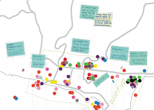
The third activity asked participants: ‘How does Daun’taun make you feel? What emotions are attached to specific locations?’. Emotions connected to heritage management practices emerged most strongly in relation to changed use of buildings, the management of the creek and change proposals in the draft site master plan. For example, the recent removal of administrative services from Kingston, particularly in relation to the New Military Barracks, was associated with worry (David, Dids, Ken), sadness (Sharyn, George), and grief (Gaye). The New Military Barracks formerly housed the Norfolk Island Government Administration services. However, these functions were moved from Kingston to Burnt Pine in 2022. Gaye observed that the New Military Barracks had been ‘really important as a working area’. Pat described this shift of administrative services out of Kingston, and other heritage management decisions, as a strategy to ‘discourage’ the ‘use’ of Daun’taun ‘by locals’. The concerning implication of the removal of administrative services was described by Dids in relation to the transformation of Kingston into a ‘ghost town’ when it has ‘always been a working, living, playing environment’. The positive associations (happiness, awe, pride) the maps indicate as connected to the New Military Barracks reflected participants’ emotional response in relation to the past, whereas more difficult emotions (sadness, anger, grief, hurt, hostility, worry) captured feelings in the present. Some participants stuck multiple stickers of the one colour on the New Military Barracks to represent the intensity of these feelings, with Ken attaching to the area three yellow ‘worry’ stickers (see ).
Figure 6. Detailed view of emotions map highlighting feelings of worry (yellow) attached to the Pier Store and New Military Barracks.
Worry was also expressed by participants in relation to heritage management decisions concerning the creek that runs through Watermill Valley and the Kingston Common, emptying into Emily Bay. In the past, the creek had been regularly cleared of reeds, but in recent years the creek was fenced as part of the area’s cultural landscape management, specifically related to the management of cattle to address ‘water quality, erosion, spread of weeds and harm to ruins’.Footnote47 Many participants expressed that ‘the creeks should be cleared’ with a consequence of the current management practice being a change in water quality in Emily Bay (Colleen). Kym recalled that the creek ‘used to be cleaner and [was] running differently’ – ‘as kids [we] used to always be in the creek’, it was a place for ‘play’. One of the effects of this latest approach to the management of the creek is that Watermill Valley and the Kingston Common is returned to swampland. Kym expressed a wish for those in charge of KAVHA to ‘sort out all of the water that’s pooled’ in that area. Tane expressed anger in regard to the impact of the swamp on the avenue of pines along Country Road, which had been planted as part of a traditional practice that commemorates an Islander reaching the age of 100, with the same number of trees planted in their honour. Tane explained:
these Norfolk pines … are very significant and are a proud part of our cultural way of showing respect for elders that have passed on … the pine trees do not do well in this swamp that’s been created, and if you drive down there now, you will see those pine trees dying, and no one [in charge of heritage management in KAVHA] cares, there is no respect.
Whereas the creek elicited an ‘angry’ sticker, the pines had a ‘nostalgia’ sticker attached (see ). The map depicted in also featured green pine tree stickers created by a participant to signify the feeling of belonging, which further highlights the Norfolk Pine as a potent symbol of local identity. In this way, the maps and corresponding conversations capture the emotional tensions held by participants in locations across Kingston. Strong positive emotions are often tied to equally strong negative ones, particularly when intergenerational custodianship of the area and the continuity of living heritage practices are felt to be under threat from heritage management decisions.
Figure 7. Detailed view of emotions map highlighting areas in Kingston attached to feelings of anger (red), nostalgia (pink) and a sense of belonging (pines).
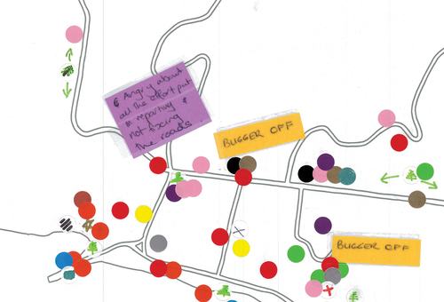
Participants also reflected on fears for the future of Kingston in reference to management decisions that might emerge from the consultancy producing the Site Master Plan, which was in progress at the time of our workshops. Worry was a common emotion attached to different areas of Kingston based on proposals in the draft plan. Damien, for instance, put a worry sticker on the Pier Store where the plan proposed a wine bar be located (see ). He noted this is not practical and it will be ‘invasive’ for people undertaking customary practices at the pier:
they want to put that big veranda out on the pier side – if you go down there now and you’ve got a good day fishing, you’ve got five or six trailers and tourists, that place is congested. If you’re gonna put in a wine bar, it takes that whole area out, but it’s also – it’ll make it feel invasive, people are watching and we’re not that sort of people. We don’t want the Byron Bay feel or anything like that.
Here, Damien is referring to the small, iconic Australian beachside town of Byron Bay, New South Wales, which has been the site of significant controversies concerning whether its ‘local character’ and lifestyle has been commodified and eroded due to tourism and development.Footnote48
For Damien, the types of changes being put forward by the heritage consultants are ‘all about progress, but progress is not necessarily the answer to everything’. Comments left on the emotion maps indicated others shared Damien’s feelings: ‘fearful of possible changes – modernising the area of Kingston’ and ‘I feel: protective of all of it, scared it will be changed forever’ (see ). What is highlighted in such comments is that the deep sense of connection participants have to Kingston also encompasses feelings of fear, anxiety and loss due to their lack of agency in decision-making processes. As Bev wrote on her individual map: ‘may they NEVER destroy our heartfelt love of this place by changing or modernising it’.
Figure 8. Detailed view of emotions map with sticky notes that capture the extent to which participants are concerned about changes to Kingston.
Kingston’s Alternative Cartographies and Subaltern Knowledges
The mapping exercises in our project highlight significant, long-standing tensions between Kingston’s management and how Norfolk Islanders understand their living heritage and ways to appropriately care for it. This is the case despite the fact that industry standards regarding heritage management have shifted in recent decades to align more closely with the needs of local communities. The materials-based approach rooted in authorised heritage discourse that was dominant in the conservation field prior to the 1990s was superseded by the turn to a values-based approach in the late 1990s with the emergence of the Burra Charter.Footnote49 Since the 2000s, there has been increasing recognition of the need for a living heritage approach to the management of heritage sites. This change followed the 2003 unveiling of the International Centre for the Study of the Preservation and Restoration of Cultural Property’s (ICCROM) five-year programme focused on sites of living heritage, which aimed ‘to increase awareness and sensitivity towards living heritage’ in the management of heritage properties ‘by encouraging the use of local resources, traditional practices and know-how; strengthening efforts to retain local craft traditions; and increasing support for social and religious activities and functions promoted by sacred places’.Footnote50
Central to a living heritage approach to management of historic places should be the involvement of the core community in defining and maintaining their heritage both as resources from the past and practices in the present and into the future. In KAVHA, such an approach would involve questioning the extent to which former and current management agendas presented in the planning documents – including through the use of maps – resonate with local priorities and uses of place. It is these local understandings that we sought to draw out in our project’s participatory mapping workshops using activities that emphasised our participants’ connection with and care for Kingston over time. While the 2023 Site Master Plan explicitly refers to the ‘living’ dimensions of Kingston’s heritage,Footnote51 that recognition is not yet attached to a living heritage approach to heritage management.
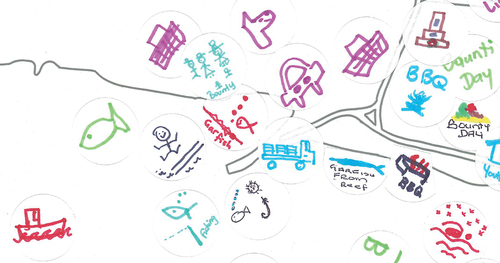
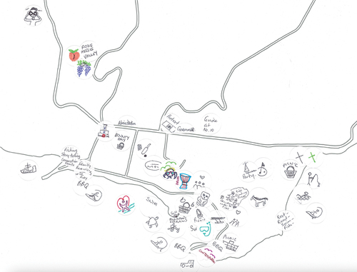
One point of intersection between the maps in the 1980 Management Plan, the 2023 Site Master Plan and those in our workshop is the focus on activities. Many of the activities documented over the years in Kingston’s management planning documents are reflected in the maps we created with our participants, including practices such as picnics and barbecues, Bounty Day, ANZAC Day, Heiva, surfing, swimming (naawi), snorkelling, diving, administration and governance, sports (cricket, rugby, golf, horse riding), fishing and resource collecting (e.g. rama), funerals, weddings, christenings, and church/worship. Our maps, however, not only captured a greater number of sites at which some of these activities take place, but our audio recordings of the workshops provided greater qualitative insight into specific memories, feelings and vernacular knowledges surrounding the activities. Our maps also captured practices that do not appear in the aforementioned plans, including birdwatching, protest (tent embassy), parking up, drumming, dancing, plaiting and weaving, reading, geocaching, romancing, flying kites, watching the sunset, hunting for golf balls, pier jumping, diving, and catching guppies in the creek and dam (see, e.g. ). The maps from our project highlight the volume and geographic spread of activities taking place across Kingston, as well as the variations in what participants consider a ‘customary’ practice (even beyond what may be considered cultural heritage according to traditional, authorised heritage discourses). In particular, the practices we documented that were not included in heritage management plans underscore the importance of recognising and protecting Norfolk Islanders’ contemporary, everyday practices.
Figure 9. Detailed view of customary practices map highlighting volume, geographic spread and variation in activities occurring across Kingston.
A second point of intersection between the maps in the 2023 Site Master Plan and those in our workshop is an interest in site mobilities. The Site Master Plan mentions local resident movement in terms of there being no ‘clear primary entry point’, with residents using all roads to enter the site.Footnote52 However, the plan’s key interest is in tourist movements and how traffic and parking might be better managed to enhance the tourist experience.Footnote53 The accompanying maps show the four entry roads to the site, vehicle access in KAVHA (limited to on-road) and informal and formal parking areas.Footnote54 Our project’s Routes maps and attendant conversations highlight that local residents do not limit their driving to defined roads or thoroughfares, but also use their cars to drive across the grass to the picnic amenities, into the Compound, or to good viewing points as well as driving on verges to avoid traffic measures like speed bumps. There was a broad consensus among participants that Kingston should remain open and accessible as it had been in the past. Similarly, the Routes maps capture how our participants walk in KAVHA in ways that are not represented in the ‘Pedestrian Movement analysis’ map in the Site Master Plan.Footnote55 In the planning map, existing walking routes are aligned with roads or well-trodden tracks such as the steps up Flagstaff, the coastal path from Lone Pine to Cemetery Beach or within the pine plantation behind Emily Bay. What is not featured is the place of the Golf Course in residents’ walking patterns. Our participatory maps show how the common land of the Golf Course offers our participants numerous routes. One participant used green dots to indicate they walk all over the Golf Course (see ), whereas others drew more specific lines to represent personalised paths (see e.g. ) that take the walker from: Quality Row down to Emily Bay; behind the pines; hugging the inner boundary of the course from the Cemetery down to the Windmill near Lone Pine; a loop from the behind the pines across to the Cemetery Beach boundary and then down to the Windmill; from the gate next to Government House across to the lower end of Cemetery Beach; from the club house down to the Windmill. Our maps draw attention to how Norfolk Islanders’ vehicular uses and pedestrian movements are not necessarily neat, uniform or contained. The focus of the maps on the past as much as the present also helps capture living heritage as evolving across space and time.
Conclusion
The participatory mapping exercises reported on in this article centre the experiences of Norfolk Islanders to draw out understandings of place that might otherwise be excluded or veiled by traditional heritage management practices. While our project’s maps highlight everyday and personal associations with place, they also direct attention to more ‘difficult’ aspects of heritage,Footnote56 such as feelings of worry, sadness and hostility or practices like protest at the tent embassy. Many of these contentious qualities of place are integral to Norfolk Islanders’ living heritage, being strongly linked to their custodianship over Kingston and their values concerning democracy and self-determination. Yet, such aspects are absent from KAVHA’s current Site Master Plan, reflecting an approach to management that continues to be underpinned by an authorised heritage discourse that ‘smooth[s] over conflict’.Footnote57 Participants’ feelings about Kingston were expressed in conversations connected to all the mapping activities in the workshops and were not confined to the placement of ‘feeling’ stickers on the Emotion maps. We would argue that documenting and taking seriously the emotional resonance of heritage places for locals – through the creation of heat maps, or by other means – would be a valuable addition to heritage management planning. The maps used in heritage planning documents tend to flatten what are in reality, complex relationships that local residents have with different spaces in the site. A focus on emotion would assist in creating plans that better capture the complexities of living heritage in a site like KAVHA.
Living heritage cannot be neatly contained in the systems of artificial division produced by maps in heritage planning documents. This is true even for the maps we created, where (as noted above) it became clear that emotions, routes and customary practices are intertwined and overlapping. The participants’ engagement with the base maps and respective activities in the Reimagining KAVHA workshops, and their observations about the site that accompanied the doing of these activities, emphasise a more holistic orientation to, and unbounded use of, Kingston which is not readily reflected in the materials-based approach that has long-dominated KAVHA’s management. Over the last 40 years, the primary consideration of the planning documents has been the conservation of the historic aspects of the site; ‘historic’ has tended to exclude twentieth century landscapes and structures and the intangible heritage of the Pitcairn Settlement, principally referring to the fabric and associated values of the two British settlements. What the outcomes of the mapping workshops suggest is that any future revisions to the management plans should consider an expanded understanding of use and attachment of local residents and particularly those who are Pitcairn Settler descendants or who have long and deep connections to Kingston. This would require an approach to heritage management that genuinely engages with Kingston’s core community as experts in and custodians of their own heritage.
Disclosure statement
No potential conflict of interest was reported by the authors.
Additional information
Funding
Notes
1. Poulios, “Discussing Strategy in Heritage Conservation,” 21.
2. Ibid., 23.
3. Department of Environment, Water, Heritage and the Arts et al., Conservation Management Plan, 66.
4. Smith, “Towards a Theoretical Framework,” 62.
5. Department of Home Affairs and Environment, KAVHA Management Plan.
6. Smith, Uses of Heritage.
7. Avrami, “Spatializing Values in Heritage Conservation,” 35.
8. Department of Environment, Water, Heritage and the Arts et al., Conservation Management Plan, 22.
9. Harley, “Maps, Knowledge, and Power”
10. Campos-Delgado, “Counter-Mapping Migration”
11. Sletto, “We Drew What We Imagined,” 445.
12. e.g. Peluso, “Whose Woods Are These?”; Boatca, “Counter-Mapping as Method”
13. e.g. Lobo et al., “Practising Lively Geographies”; Boschmann and Cubbon, “Sketch Maps and Qualitative GIS”
14. e.g. Sletto, “We Drew What We Imagined”; Rye and Kurniawan, “‘Claiming Indigenous Rights”
15. Wainwright and Bryan, “Cartography, Territory, Property,” 153.
16. Ibid., 169.
17. Reitz, “Back to the Drawing Board,” 328.
18. Ibid. 327.
19. Campos-Delgado, “Counter-Mapping Migration”
20. Kim, “Critical Cartography 2.0,” 215.
21. Avrami, “Spatializing Values in Heritage Conservation”; Brown, “Aboriginal Cultural Heritage Management and Mapping”; Byrne and Nugent, Mapping Attachment; Byrne, “Counter-Mapping”; Harrison, “’Counter-Mapping’ Heritage, Communities and Places”; La Frenierre, “Mapping Heritage”; Nanda and Khare, “Spatial Mapping of ‘People – Place Ties’.”
22. Schofield, “Heritage Expertise and the Everyday,” 2.
23. Álvarez Larrain and McCall, “Participatory Mapping and Participatory GIS,” 663.
24. Harrison, “’Counter-Mapping’ Heritage, Communities and Places,” 81.
25. Ibid., 91.
26. De Nardi, “Senses of Place, Senses of the Past,” 6.
27. Hussain, “’Drawing In’ Other Worlds,” 127.
28. Harrison, “’Counter-Mapping’ Heritage, Communities and Places,” 90.
29. Álvarez Larrain and McCall, “Participatory Mapping and Participatory GIS’; Avrami, ‘Spatializing Values in Heritage Conservation”
30. Australian Bureau of Statistics, “Ancestry, Language and Birthplace”
31. Human Rights and Equal Opportunity Commission, “Territorial Limits”
32. Australian Government, Norfolk Island Act 1979, 3; Wettenhall, “Norfolk Island as Region.”
33. Ibid.
34. Nobbs, Fateful Choices.
35. See, e.g. Gibbs et al., “The Free and Unfree Settlements”; Nobbs, “KAVHA: Part II”
36. Nobbs, Procrustes Ascendant, 44.
37. Norfolk Island Council of Elders and Norfolk Island People for Democracy, “Media Release”
38. Department of Home Affairs and Environment, KAVHA Management Plan.
39. Australian Government, Department of Infrastructure, Transport, Regional Development, Communications and the Arts et al., Kingston Site Master Plan.
40. Baker et al., Popular Music Heritage, 61.
41. See Baker and Cantillon, ‘Zines as Community Archive’
42. Muzaini and Minca, “Rethinking Heritage, but ‘From Below’”
43. Smith, “Foreword,” xi.
44. Buffett, Speak Norfolk Today; Nobbs-Palmer, A Dictionary of Norfolk Words.
45. To contextualise the locations mentioned throughout this section, we encourage readers to refer to the official Kingston visitors’ map: https://kingston.norfolkisland.gov.au/sites/default/files/documents/kavha_visitors_map.pdf.
46. Hutchinson, “Bounty Street Bridge”
47. GML Heritage + Context, “Cultural Landscape Management Plan”
48. See, e.g. Green, “Notions of Town Character”
49. See Poulios, “Discussing strategy in heritage conservation”
50. Wijesuriya, “Living Heritage,” 43.
51. Australian Government, Department of Infrastructure, Transport, Regional Development, Communications and the Arts et al., Kingston Site Master Plan, 4, 5, 10, 20, 28.
52. Ibid., 38.
53. Ibid., 38, 42.
54. Ibid., 42, 43.
55. Ibid., 45.
56. Macdonald, Difficult Heritage.
57. Waterton et al., “The Utility of Discourse Analysis,” 339.
Bibliography
- Álvarez Larrain, A., and M. K. McCall. “Participatory Mapping and Participatory GIS for Historical and Archaeological Landscape Studies: A Critical Review.” Journal of Archaeological Method and Theory 26, no. 2019 (2019): 643–678. doi:10.1007/s10816-018-9385-z.
- Australian Bureau of Statistics. “Understanding Ancestry, Language and Birthplace of the Norfolk Island Population.” 1 December 2022. https://www.abs.gov.au/articles/understanding-ancestry-language-and-birthplace-norfolk-island-population#:~:text=Norfolk%20Island%20was%20re%2Dincluded,from%201%2C748%20people%20in%202016
- Australian Government. “Norfolk Island Act 1979.” Accessed 1 August 2023. https://www.legislation.gov.au/Details/C2014C00577
- Australian Government. “Department of Infrastructure, Transport, Regional Development, Communications and the Arts, Conrad Gargett, GML Heritage, SMA Tourism, and Tract. “Kingston Site Master Plan Volume 1.” February 2023. https://kingston.norfolkisland.gov.au/sites/default/files/documents/Kingston%20Site%20Master%20Plan%20-%20Volume%201.pdf
- Avrami, E. “Spatializing Values in Heritage Conservation: The Potential of Cultural Mapping.” In Values in Heritage Management: Emerging Approaches and Research Directions, edited by E. Avrami, S. Macdonald, R. Mason, and D. Myers, 35–49. Los Angeles: The Getty Conservation Institute, 2019.
- Baker, S., and Z. Cantillon. “Zines as Community Archive.” Archival Science 22, no. 4 (2022): 539–561. doi:10.1007/s10502-022-09388-1.
- Baker, S., Z. Cantillon, and R. Nowak. Popular Music Heritage, Cultural Justice and the Deindustrialising City. Cambridge: Cambridge University Press, 2023.
- Boatca, M. “Counter-Mapping as Method: Locating and Relating the (Semi-)Peripheral Self.” Historical Social Research 46, no. 2 (2021): 244–263. doi:10.12759/hsr.46.2021.2.244-263.
- Boschmann, E. E., and E. Cubbon. “Sketch Maps and Qualitative GIS: Using Cartographies of Individual Spatial Narratives in Geographic Research.” The Professional Geographer 66, no. 2 (2014): 236–248. doi:10.1080/00330124.2013.781490.
- Brown, O. “Aboriginal Cultural Heritage Management and Mapping: Aspects of Cultural Boundaries, Sub-Bioregions and Site Distribution in the Sydney Basin.” Archaeological Heritage 2, no. 1 (2010): 9–16.
- Buffett, A. Speak Norfolk Today: An Encyclopaedia of the Norfolk Island Language. Norfolk Island: Himii Publishing Company, 1999.
- Byrne, D. “Counter-Mapping: New South Wales and Southeast Asia.” Transforming Cultures eJournal 3, no. 1 (2008): 256–264. doi:10.5130/tfc.v3i1.687.
- Byrne, D., and M. Nugent. Mapping Attachment: A Spatial Approach to Aboriginal Post-Contact Heritage. Sydney: Department of Environment and Conservation, 2004.
- Campos-Delgado, A. “Counter-Mapping Migration: Irregular Migrants’ Stories Through Cognitive Mapping.” Mobilities 13, no. 4 (2018): 488–504. doi:10.1080/17450101.2017.1421022.
- De Nardi, S. “Senses of Place, Senses of the Past: Making Experiential Maps as Part of Community Heritage Fieldwork.” Journal of Community Archaeology & Heritage 1, no. 1 (2014): 5–22. doi:10.1179/2051819613Z.0000000001.
- Department of Environment, Water, Heritage and the Arts, NSW Department of Commerce, Government Architect’s Office, and Otto Scerhalmi & Partners Pty Ltd. “Kingston and Arthur’s Vale Historic Area: Conservation Management Plan.” 2008. Accessed 3 June 2021. https://whc.unesco.org/document/105331.
- Department of Home Affairs and Environment. Norfolk Island, Kingston and Arthur’s Vale Historic Area Management Plan. Canberra: Australian Government Publishing Service, 1981.
- Gibbs, M., B. Duncan, and R. Varman. “The Free and Unfree Settlements of Norfolk Island: An Overview of Archaeological Research.” Australian Archaeology 83, no. 3 (2017): 82–99. doi:10.1080/03122417.2017.1404732.
- GML Heritage + Context. “Kingston and Arthur’s Vale Historic Area (KAVHA) – Cultural Landscape Management Plan (CLMP): Consultation Outcomes Report.” September 2019. https://kingston.norfolkisland.gov.au/sites/default/files/documents/KAVHA_Cultura_%20Landscape_Management_Plan_Consultation_Outcomes_Report.pdf
- Green, R. “Notions of Town Character.” Australian Planner 37 (2000): 76–86. doi:10.1080/07293682.2000.9657881.
- Harley, J. B. “Maps, Knowledge, and Power.” In The Iconography of Landscape, edited by D. Cosgrove and S. Daniels, 277–312. Cambridge: Cambridge University Press, 1988.
- Harrison, R. “Counter-Mapping’ Heritage, Communities and Places in Australia and the UK.” In Local Heritage, Global Context: Cultural Perspectives on Sense of Place, edited by J. Schofield and R. Szymanski, 79–98. Farnham: Ashgate, 2011.
- Human Rights and Equal Opportunity Commission. “Territorial Limits: Norfolk Island’s Immigration Act and Human Rights.” 1999. https://humanrights.gov.au/sites/default/files/document/publication/norfolk_island.pdf
- Hussain, Z. “‘Drawing In’ Other Worlds: Addressing Fragile Heritage Landscapes Through Cosmopolitical Maps.” Journal of Community Archaeology & Heritage 8, no. 2 (2021): 127–141. doi:10.1080/20518196.2021.1894765.
- Hutchinson, E. “Taking Action to Preserve the Bounty Street Bridge.” Department of Infrastructure, Transport, Regional Development, Communications and the Arts, 16 January 2020. https://www.infrastructure.gov.au/territories-regions-cities/territories/norfolk_island/administrator/media/2020/ni-a-mr-202002
- Kim, A. M. “Critical Cartography 2.0: From ‘Participatory Mapping’ to Authored Visualizations of Power and People.” Landscape and Urban Planning 142 (2015): 215–225. doi:10.1016/j.landurbplan.2015.07.012.
- La Frenierre, J. “Mapping Heritage: A Participatory Technique for Identifying Tangible and Intangible Cultural Heritage.” The International Journal of the Inclusive Museum 1, no. 1 (2008): 97–104. doi:10.18848/1835-2014/CGP/v01i01/44319.
- Lobo, M., M. Duffy, A. Witcomb, C. Brennan-Horley, D. L. Kelly, K. Barry, D. Bissell, et al. “Practising Lively Geographies in the City: Encountering Melbourne Through Experimental Field-Based Workshops.” Journal of Geography in Higher Education 44, no. 3 (2020): 406–426. doi:10.1080/03098265.2020.1712684.
- Macdonald, S. Difficult Heritage: Negotiating the Nazi Past in Nuremberg and Beyond. London: Routledge, 2009.
- Muzaini, H., and C. Minca. “Rethinking Heritage, but ‘From Below.” After Heritage: Critical Perspectives on Heritage from Below, edited byM. Hamzah, and M. Claudio, 1–21. Cheltenham: Edward Elgar Publishing, 2018.
- Nanda, G., and A. Khare. “Spatial Mapping of ‘People–Place Ties’ as an Integral Part of Heritage Management Process.” Journal of Heritage Management 3, no. 2 (2019): 192–208. doi:10.1177/2455929618807984.
- Nobbs, C. Australia’s Assault on Norfolk Island 2017–2018: Fateful Choices. Norfolk Island: Chris Nobbs, 2019.
- Nobbs, C. KAVHA: Part II—Management Since the Commonwealth Takeover in 2015. The Norfolk Islander, October 12 2019.
- Nobbs, C. Australia’s Assault on Norfolk Island 2019–2020: Procrustes Ascendant. Norfolk Island: Chris Nobbs, 2021.
- Nobbs-Palmer, B. A Dictionary of Norfolk Words and Usages Plus English-Norfolk Appendix. Norfolk Island: B.N. Palmer, 1986.
- Norfolk Island Council of Elders and Norfolk Island People for Democracy. “Media Release: Our Continuing Fight for Democracy.” The Norfolk Islander 56, no. 25 (January 29,2022).
- Peluso, N. L. “Whose Woods are These? Counter-Mapping Forest Territories in Kalimantan, Indonesia.” Antipode 27, no. 4 (1995): 383–406. doi:10.1111/j.1467-8330.1995.tb00286.x.
- Poulios, I. “Discussing Strategy in Heritage Conservation: Living Heritage Approach as an Example of Strategic Innovation.” Journal of Cultural Heritage Management and Sustainable Development 4, no. 1 (2014): 16–34. doi:10.1108/JCHMSD-10-2012-0048.
- Reitz, T. “Back to the Drawing Board: Creative Mapping Methods for Inclusion and Connection.” In Co-Creativity and Engaged Scholarship Transformative Methods in Social Sustainability Research, edited by A. Franlin, 323–355. Cham: Plagrave Macmillan, 2022.
- Rye, S. A., and N. I. Kurniawan. “Claiming Indigenous Rights Through Participatory Mapping and the Making of Citizenship.” Political Geography 61 (2017): 148–159. doi:10.1016/j.polgeo.2017.08.008.
- Schofield, J. “Heritage Expertise and the Everyday: Citizens and Authority in the Twenty-First Century.” In Who Needs Experts? Counter-Mapping Cultural Heritage, edited by J. Schofield, 1–11. London: Routledge, 2016.
- Sletto, B. I. “‘We Drew What We Imagined’ Participatory Mapping, Performance, and the Arts of Landscape Making.” Current Anthropology 50, no. 4 (2009): 443–476. doi:10.1086/593704.
- Smith, L. Uses of Heritage. London: Routledge, 2006.
- Smith, L. “Towards a Theoretical Framework for Archaeological Heritage Management.” In The Heritage Reader, edited by G. Fairclough, R. Harrison, J. H. J. Jnr, and J. Schofield, 62–74. London: Routledge, 2008.
- Smith, L. T. “Foreword.” In Decolonizing Research: Indigenous Storywork as Methodology, edited by J. Archibald, J. Lee-Morgan, and J. De Santolo, xi–xii. London: Zed Books, 2019.
- Wainwright, J., and J. Bryan. “Cartography, Territory, Property: Postcolonial Reflections on Indigenous Counter-Mapping in Nicaragua and Belize.” Cultural Geographies 16 (2009): 153–178. doi:10.1177/1474474008101515.
- Waterton, E., L. Smith, and G. Campbell. “The Utility of Discourse Analysis to Heritage Studies: The Burra Charter and Social Inclusion.” International Journal of Heritage Studies 12, no. 4 (2006): 339–355. doi:10.1080/13527250600727000.
- Wettenhall, R. “Norfolk Island as Region: A Pacific Puzzle.” Australian Journal of Public Administration 77, no. 1 (2017): 120–127. doi:10.1111/1467-8500.12258.
- Wijesuriya, G. “Living Heritage.” In Sharing Conservation Decisions: Current Issues and Future Strategies, edited by A. Heritage and J. Copithorne, 43–56. Rome: ICCROM, 2018.
