
ABSTRACT
Abandoned oil and gas wells, improperly plugged or unplugged, present a risk to current and future oil and gas development because they provide a potential pathway for unwanted gas and fluid migration to the surface. The appropriate emission factor for gaseous emissions from these wells is uncertain, as a limited number of studies have reported abandoned wells as a methane emissions source. A helicopter-based survey that mapped methane concentration and located wells by detecting magnetic anomalies was conducted in Hillman State Park in southwestern Pennsylvania. Although well finding via aerial survey was successful, elevated methane concentrations due to emissions from wells in the survey area were not detected by helicopter as abandoned wells were likely too small a source of methane to detect from elevations that helicopters fly at (tens of meters). Measurement of methane emission rates from 31 wells were collected using several techniques that are compared and evaluated for their effectiveness: Hi Flow sampler, field-portable flame ionization detector, infrared camera, dynamic flux chamber and bag sampling. Nine of the 31 wells were buried; average methane flux for these wells was not statistically different from the background. Mass flow rate from the remaining 22 wells ranged from non-detection (less than 0.09 kg CH4/day) to 4.18 kg CH4/day with a mean of 0.70 kg/well/day (median of 0.24 kg CH4/day/well) and a sample standard of error of 0.21 kg CH4/well/day. This emission factor, while not intended for exclusive use in developing a methane emissions inventory for abandoned oil and gas wells, contributes to the growing amount of methane emissions data for this source category. The results from the aerial survey, ground-based well location verification and emissions measurements, and the evaluation of measurement approaches described here, provide a comprehensive characterization of abandoned wells in one field that can inform future measurement studies.
Introduction
Abandoned oil and gas wells, improperly plugged or unplugged, present a risk to current and future oil and gas development because they provide a potential pathway for unwanted gas and fluid migration to the surface. The appropriate emission factor for gaseous emissions from these wells is uncertain, as a limited number of studies have reported abandoned wells as a methane emissions source [Citation1–4]. Methane, the primary component of natural gas, is a potent greenhouse gas (GHG) with a global warming potential 84–86 times that of carbon dioxide (CO2) over a 20-year period [Citation5]. The US Environmental Protection Agency (EPA)'s inventory of domestic GHG emissions in 2015 identifies natural gas systems as the second largest anthropogenic source of methane emissions in the United States after enteric fermentation with 162.4 million metric tons of CO2 equivalent (MMT CO2 eq) emitted [Citation101]. Petroleum-related systems emitted 39.9 MMT CO2 eq [Citation101]. Current estimates of the GHG footprint of oil and natural gas systems must be updated to incorporate both results from on-site emissions monitoring and emission inventory data that accurately reflect industry operations.
Some of the uncertainty in methane emissions estimates derives from different measurement approaches. ‘Top-down’ approaches estimate source emissions from sites or regions based on ambient methane concentration measurements. ‘Bottom-up’ approaches inventory emissions from individual sources, either from direct measurements or from applying emission factors to activity levels. When top-down and bottom-up methane emissions estimates for natural gas sources are compared, the higher estimates typically come from top-down approaches. This disagreement suggests inaccurate attribution of methane to natural gas sources in the top-down studies, underestimation of emissions in the bottom-up studies and/or the presence of unaccounted sources in the bottom-up techniques [Citation6–9]. Although the EPA is currently working to add this emissions source category, to date abandoned wells have not been included in EPA domestic GHG emissions inventories as a potential source of methane emissions [Citation10,Citation101].
Kang et al. [Citation2] reported methane emission rates from 19 abandoned wells, five of which had been plugged, in Potter and McKean counties in Pennsylvania. Methane emissions measurements were made using a static flux chamber, with a mean result of 0.27 kg CH4/day/well. Although acknowledging that the sample size was small when considering the hundreds of thousands of wells in the state, the authors assumed the measured wells were representative of wells across the state and scaled up their results to approximate the portion of current total anthropogenic methane emissions in Pennsylvania from abandoned wells at 4–7%. An updated study by Kang et al. [Citation3] revised this estimate, based on measurements from 88 abandoned wells in Pennsylvania and a more detailed analysis of the number of abandoned wells in the state, to 5–8%. Emission rates reported in Kang et al. [Citation3] ranged from 2.88 × 10⁻⁷ to 2.76 kg CH4/day/well with distinctions made between plugged and unplugged wells, type of well (gas or oil and combined oil/gas), and whether or not the well was in a region with mineable coal seams. Townsend-Small et al. [Citation4] reported methane emission rates from 138 abandoned oil and gas wells in four geographic regions in the United States, 119 of which were plugged and the remaining 19 were unplugged. Average methane emission rates were 0.002 g CH4/h (4.8 × 10⁻⁵ kg CH4/day) for the plugged wells and 10.02 g CH4/h (0.24 kg CH4/day) for the unplugged wells. Additionally, significantly different averages were reported for wells in the eastern US versus western US. The implication of the results of these studies is that this previously unaccounted source has the potential to be significant and more data are needed to further characterize this emission source.
Pennsylvania has a long history of oil and gas drilling, beginning with the first commercial oil well, the Drake well in Titusville, in 1859. Documentation on the location and state of abandonment of many of the early wells is nonexistent, since they were drilled before modern regulations and reporting requirements. Requirements for standardized plugging of wells using cement were not in effect until the 1950s [Citation102]. The Pennsylvania Department of Conservation and Natural Resources (PA DCNR) makes records for over 180,000 oil and gas wells in the state publicly available via the Exploration and Development Well Information Network (EDWIN, http://www.dcnr.state.pa.us/topogeo/econresource/oilandgas/EDWIN_home/index.htm). Due to many wells being drilled prior to the 1960s, before legislation was passed that required wells to be permitted and locations recorded, there are a large number of inaccurate records and/or undocumented wells, with estimates of total wells ranging from 300,000 to 750,000 [Citation2,Citation3,Citation11,Citation103]. The Pennsylvania Department of Environmental Protection (DEP)'s abandoned and orphan well program defines rules for abandoned or orphaned status and addresses the plugging of wells that have no identifiable operator or owner [Citation104]. Well plugging is expensive and state resources are not available to find and plug every well; hence, mitigation is prioritized to target wells that pose of significant health and safety concerns [Citation103]. The shale gas boom that led to proposed regulation that requires Pennsylvania operators to identify the locations of orphan and abandoned wells within a 1000-ft (305-m) buffer prior to hydraulic fracturing of new unconventional horizontal wells has fostered a renewed interest in mitigating the risk presented by abandoned wells [Citation105].
Reported here are results of a field campaign designed to test several methods of measuring methane emissions from abandoned wells and to measure methane emission rates from a sample of wells in the study area. Differences between this study and previous efforts are the methods used to locate the wells, the range of techniques used to measure their emissions, and an assessment of their effectiveness. This study utilizes an aeromagnetic survey to locate wells within a specific region, while other studies relied on state and other databases for well location, and in some cases permission from landowners to access wells [Citation1–4]. Previous studies used a single method to quantify methane emission rate from each well (static or dynamic flux chambers, high flow sampling, soil flux measurements) with no comparative analysis to validate results against a different measurement technique [Citation1–4]. Additionally, previous studies did not examine soil methane flux above unplugged wells that had been buried. Boothroyd et al. [Citation1] reported methane flux from 102 wells in the UK that had been decommissioned, which means that they had been cut off, sealed and buried with ∼2 m of soil. The buried wells examined in this study are assumed to not be plugged to modern standards and therefore may have a greater risk of methane migration to the surface. The study area, Hillman State Park, was chosen because of the high concentration of abandoned wells within the park and the likelihood that the wells would be unplugged due to their vintage. Data from this study can inform future development of a methane emission factor for abandoned wells with the ultimate objective of building a methane emissions inventory for abandoned wells in the United States.
Materials and methods
Study area: Hillman State Park
Hillman State Park is a 15-km2 (3 600-acre) park in Washington County in southwestern Pennsylvania. The park is primarily used for recreation. The current land area of the park is underlain by the Florence-Five Points oil field, which was discovered in the late 1800s and was fully developed by 1915 [Citation12]. Therefore, given the development period of the field, the wells drilled in Hillman State Park are likely ineffectively plugged or not plugged at all. Accurate records including exact locations of all the wells do not exist, and the state database EDWIN shows 34 wells within the park. However, based on historic maps from 1911, an estimated 191 wells were drilled, with depths generally ranging from 549 to 610 m (1800 to 2000 ft) [Citation12,Citation106]. The wells in the park, all of which are no longer active, were originally drilled for oil with initial production rates ranging from 100 to 500 barrels/day, but at least some wells likely co-produced gas during their lifetime of production (records are not available or complete for this period – late 1800s–1915).
Approximately half of the park was extensively surface mined by the Harmon Creek Coal Corporation to access Pittsburgh Coal from the 1930s through the mid-1960s. Most of the wells had been abandoned prior to the coal mining operations. Oil wells drilled in the coal-mined areas had casings cut off at the bottom of the coal seam. The wells were then covered with backfilled mine spoil in a cut-and-fill operation, leaving no surface evidence. The depth of cover over the 98 wells in the mined area ranged from a few ft to over 100 ft. The estimate was derived by comparing topographic data from United States Geological Survey (USGS) maps in 1906 to light detection and ranging (LiDAR) elevation data from 2005 and confirmed using geophysical methods at several well sites to determine depth of cover [Citation13]. Although there is no confirmation that these buried wells are unplugged, the wells had been abandoned prior to adoption of modern plugging standards (1950s) and prior to the coal mining operations that resulted in them being buried (1930s–1960s). Additionally, there are no records of plugging of the wells in the park. Therefore, it is assumed that the buried wells examined in this study are unplugged.
Aerial-based measurement methods
On July 25–26, 2014, a helicopter-based methane and magnetic survey was flown over the park to obtain accurate locations for the wells and to determine whether methane emissions from them or other significant sources in the park could be detected during such a survey. Aeromagnetic surveys effectively locate wells by detecting the unique magnetic signature of vertical, steel well casing, even if the top of the casing is tens of feet below the ground surface [Citation14]. The transverse boom-mounted dual Scintrex (CS-3) cesium vapor sensors collected magnetic soundings on two sensor channels, acquired at a sampling rate of 10 Hz and an average altitude of 46.3 m above ground level. The flight direction was magnetic north–south (351 degrees) on a 30-m line spacing. For the methane survey the helicopter was equipped with a Picarro 2201-i, a cavity ring-down spectrometer that measures ambient methane and carbon dioxide concentration and carbon isotopes from both carbon dioxide and methane. A length of Teflon tubing ran from outside the helicopter, secured to one of the struts, to the instrument in the helicopter cockpit. A Boreal Laser GasFinder AB, a tunable diode laser-based detector, was secured to the belly of the helicopter to measure the ambient concentration of methane in the column of air below the instrument. Having two methane analyzers on board allowed for comparative measurements of methane concentration. Minimum detection limits and accuracy per manufacturer specifications for these instruments and others used in this study are given in .
Table 1. Minimum detection limit (MDL) and accuracy for methane detection instruments used in this study.
Ground-based measurement methods
For the ground-based methane emissions measurements, several approaches were used to collect both qualitative and quantitative information. Where possible, two measurement techniques were used at a single well to compare results. Additionally, repeat measurements were made at a subset of wells to observe measurement accuracy and measurement-to-measurement variability. Using global positioning system (GPS) locations of the magnetic anomalies from the aerial survey, the area was investigated to verify the existence of a well, and if a well was found, an RKI Instruments GX-2012 handheld gas detector with catalytic combustion and thermal conductivity methane sensors was used to check various potential leak points. This information was used for deciding which wells to target for leak rate measurement. Wells were not excluded from further emissions measurements if no leaks were detected with the handheld unit as small leaks may not register given the sensitivity of the GX-2012 (about 100 ppm, see ). As it was desirable to collect data from a representative sample of wells within the park, attempts were made to select 5–10 wells from each of these results from the initial leak checks: no leaks detected; small leak detected (GX-2012 registered 100–200 ppm); several leaks or one large leak detected (GX-2012 registered greater than 200 ppm). Unplugged status was verified by field observations, with the exception of the buried wells that were not excavated to determine whether or not the well had been plugged before being buried.
At the subset of wells selected for leak rate measurement, a FLIR GF320 infrared camera and a Thermo Scientific TVA 1000 portable vapor analyzer with photo ionization detection (PID) and flame ionization detection (FID) were used to find leaks (). Although the images from the infrared camera cannot be used to quantify methane emission rates, the infrared camera was useful in providing visual evidence of leak location, as with most wells many potential leak points exist. Snapshots and/or video were recorded if leaks were visible. Conditions under which the infrared camera was used were noted, as the camera's ability to detect leaks is impacted by temperature, wind conditions and cloud cover. The conditions encountered during this study varied, with temperatures between 10 and 28 °C, from no wind to moderate and variable winds, and from overcast to clear skies. The TVA 1000 was used in FID mode in a screening process to search for leaks from the wellhead as well as the ground surface in the area around the well. If the casing was corroded or cracked beneath the ground surface, or if the well had been buried, gas migration through the soil could result in leakage detected at ground level in the area around the well. For the case of targets with no surface evidence of a well, a Gem Systems GSM-19 portable Overhauser magnetometer was used to collect total field magnetic data, and the location of the highest reading was assumed to be directly above the well. In both cases, FID measurements at ground level every foot from the well out to 10 ft in the north, south, east and west directions were collected. At two wells, 163 and 177, a larger 225 ft × 225 ft area around the well was screened to investigate the potential of gas migration to the surface at a location further away from the well. The screener collected measurements in a grid pattern with one measurement every 25 ft for total of 100 measurements. Calibration checks were performed on the TVA 1000 with zero air and a 500-ppm methane calibration standard approximately weekly.
A Hi Flow sampler (Heath Consultants, Inc.), a natural gas leak rate measurement instrument in a backpack with a sampling hose assembly that uses catalytic oxidation for methane detection at low concentrations (0–5% methane) and thermal conductivity for high concentrations (5–100% methane), was used to quantify methane flow rates from wells with intact casing or an existing wellhead (). The hose end could be equipped with several different attachments to fully capture the leak. Pipe openings, flanges, elbows, the annulus between the casing and wooden box-type surface conductor, and any other potential emission points were tested for leaks. Recently, the accuracy of the Hi Flow sampler has been questioned due to problems transitioning from the catalytic to thermal conductivity sensor [Citation15]. In response, the manufacturer, Bacharach, did not validate the study results but recommended frequent calibrations. Therefore, the Hi Flow sampler used for this study was calibrated monthly as per manufacturer recommendations. As the Hi Flow sampler is not methane specific, the presence of gases other than methane can decrease accuracy. However, a correction can be applied using gas composition if the non-methane hydrocarbon content is significant. To determine the methane flow rate, the percentage of carbon accounted for by methane is multiplied by the total gas flow rate [Citation16]. A subset of five wells were sampled for gas composition. Gas was collected in an air-tight syringe and subsequently analyzed with an Inficon Fusion Micro Gas Chromatograph (Inficon, Syracuse, NY).
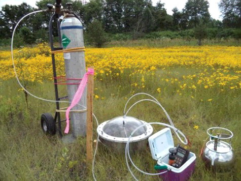
Methane flux from buried wells, around wells where increased methane concentration was detected with the FID screening, and wells with the top of the casing near flush to the ground surface was measured using the US EPA surface emission isolation flux chamber (flux chamber), which is a validated dynamic flux chamber technology recommended for assessing area source emissions [Citation17]. The flux chamber, pictured in , consisted of a continuously stirred tank reactor (CSTR) supplied with ultra-pure air at a constant flow rate of 5 L/min as controlled with a rotameter. After an equilibration period of five residence times in the chamber (30 minutes), gas samples were withdrawn for methane concentration analysis using on-site analytical instrumentation or collected in a transfer media such as 5-L Tedlar bags. For this study, an Ultraportable Los Gatos Research (LGR) methane analyzer (), which measures methane concentration using a cavity-enhanced absorption technique, was used for on-site methane concentration measurements, with the exception of a few cases in which the instrument battery power was insufficient or the distance to carry the analyzer to the well was considered too far. For these exceptions Tedlar bags were used to collect a sample, which was analyzed with the LGR instrument upon return to the laboratory. Calibration checks for the LGR instrument using mixtures of zero air and methane to achieve 0, 20 and 100 ppm methane were performed approximately once per week. Flux is calculated as:(1) where F is flux in kg/m2-day, Q is flow rate (converted from L/min to m3/day), C is concentration of methane (converted from ppm to kg/m3) and A is the area of the chamber (0.13 m2).
Figure 1. US EPA dynamic flux chamber technology: a continuously stirred tank reactor (CSTR) supplied with a constant flow of ultra-pure air. Thermometer and flow meter are housed in the small cooler.
At a small number of wells the leaks were difficult to capture using the above techniques because of either multiple leak points identified at the wellhead or difficulty isolating a leak in the annulus between the well casing and ground surface. In these instances bag sampling according to the EPA Protocol for Equipment Leak Emission Estimates was employed [Citation107]. The method involves using flexible Mylar bags of various sizes to custom fit a containment around a potential leak source. Sweep air was added to the containment at a known flow rate (from 5 L/min up to 100 L/min). The exhaust concentration of methane from the bag measured using the LGR analyzer was recorded once a steady value was achieved. Given the exhaust methane concentration and flow rate of sweep air, an emission rate was calculated as:(2) where E is emission rate in kg CH4/day, Q is flow rate (converted from L/min to m3/day), and Cout and Cin are concentration of methane (converted from ppm to kg/m3) in the air coming out of and going into the bag, respectively.
Background measurements
A characterization of background methane flux from soil in Hillman State Park is required to determine the significance of flux chamber measurements above or near the wells. Four background flux measurements were made by locating the flux chamber in an area at least 10 m from known well locations. Different ground cover types were sampled with methane flux measurement results as follows: mowed grass, 2.6 × 10⁻⁵ kg/m2-day; grassy field, 1.7 × 10⁻⁵ kg/m2-day; sparse wooded area, 3.0 × 10⁻⁶ kg/m2-day; and dense wooded area, 4.0 × 10⁻⁶ kg/m2-day. The average blank methane flux was therefore 1.3 × 10⁻⁵ kg/m2-day with a standard deviation of 1.1 × 10⁻⁵ kg/m2-day.
Results
Aerial survey results
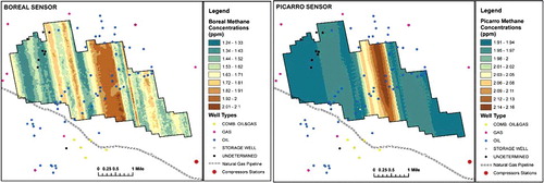
shows the airborne survey results from the Picarro and the Boreal GasFinder instruments. The Boreal GasFinder consistently recorded lower concentrations than the Picarro, by 0.1–0.6 ppm. However, results for both analyzers showed typical ambient methane concentrations for the entire survey area, indicating no major sources of methane within the survey boundary. The striping artifact visible in the maps is due to minor instrument drift from one helicopter pass to another over the survey block. Abandoned oil and gas wells in and near the park were theorized to be too small a source of methane for emissions to be detected from individual wells at the 40–50 m elevation where the survey was flown.
Figure 2. Aerial methane survey results for Hillman State Park.
The magnetic results from the airborne survey are shown in . Further details of the airborne survey are supplied in Sams, Veloski, Diehl, and Hammack [Citation13]. One hundred and sixty-five targets were selected as potential legacy wells from the aeromagnetic line data using a combination of methods [Citation13]. A ground-based crew verified the location of wells and screened wells with the handheld methane analyzer. Eighty sites were field checked with 51 confirmed wells (examples shown in ). The remaining 29 sites are likely wells but no evidence (casing, wooden conductor box, hand-forged nails, pump jacks, flow line piping and other hardware) was found to verify the well location. A subset of 31 of the wells were selected for methane emission measurements based on accessibility (distance from a road or trail), and efforts were made to sample several of each type of well: deeply buried wells (more than 2 ft below ground surface), shallowly buried wells (less than 2 ft below ground surface), or wells with intact surface expression, whether an above-ground pipe or existing wellhead. Location coordinates and pictures of the 31 wells can be found in the Supplementary data.
Figure 3. Airborne magnetic survey results for Hillman State Park.
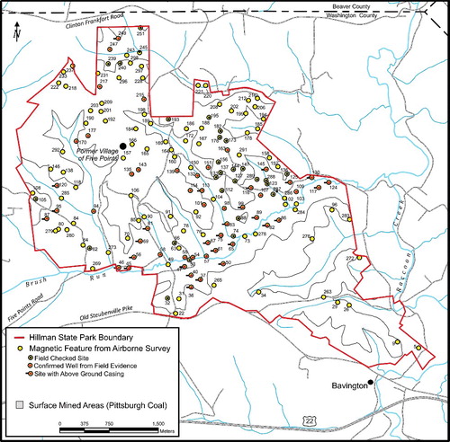
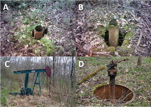
Figure 4. Hillman State Park wells 36 (A), 40 (B), 125 (C) and 130 (D).
Measurement results for buried wells
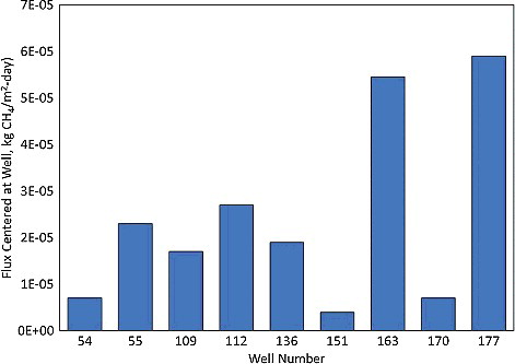
Nine of the 31 sampled wells were buried (i.e. they had no surface expression). In all cases, FID screening revealed no concentrations significantly different from background above and around the estimated well location, including wells 163 and 177, for which an extended screening area (225 ft × 225 ft) was sampled. Note that these broad sweeps were used to demonstrate the localized effect, if any, an abandoned well may have on the methane flux of the surrounding area. In and Table SI-1, flux results are displayed along with a description of the ground surface. The flux chamber measurement was repeated on two different days at well 163 with similar results (4.9 × 10⁻⁵ and 6.0 × 10⁻⁵ kg/m2-day). Methane flux measured from the ground surface directly above buried wells was statistically insignificantly different from background methane soil flux (Student's two-tailed t-test, tested at a significance value of p = 0.05). Similar to the background soil flux measurements, methane flux was highest in grassy areas and lower in wooded areas.
Figure 5. Results of flux measurements made with the flux chamber at buried well sites.
Measurement results for wells with above-ground structure
A leak is defined as the observation of methane emissions, whether detected by infrared camera, positive Hi Flow sampler or bag sampling measurement, or soil flux that is significantly higher than background. and Table SI-2 show the results for FID screening and flux measurements made with the Hi Flow sampler and the flux chamber for 22 of the 31 wells that had some surface structure, whether a ground-level open casing or a wellhead. In Table SI-2 Hi Flow sampler measurements are given in mass flow rate (kg CH4/day) and flux (kg/m2-day ), which required an estimation of leak area. Mass flow rate for the 22 wells ranged from non-detection (less than 0.09 kg CH4/day) to 4.18 kg CH4/day. No trends were observed in emission magnitude related to geographical location of the well or topography ( and ). The higher-emitting wells (120, 83, 99, 40, 47, 45 and 69) were not clustered in the same area, nor was their presence on a hill or in a valley consistent. The same is true for the wells that emitted little or no measurable amount of methane.
Figure 6. Results of emission rate measurements for wells that have existing surface structure made with the Hi Flow (HF) sampler and bag sampling. Where multiple Hi Flow measurements were made, each measurement is shown as well as the average with the error bar representing the standard deviation. Otherwise, error bars indicate ± 20% for bag sampling as per EPA [Citation107] and ± 10% for Hi Flow sampling as per manufacturer's specifications (). The gray demarcation on the x-axis shows when flame ionization detection (FID) screening detected a possible leak (right side of graph) or not (left side of graph). For wells at which the infrared camera detected a leak, the bars show a striped pattern. The infrared camera was not used for wells 56 and 67. Wells at which no leaks were detected are shown at the detection limit (0.01 kg CH4/day and 0.09 kg CH4/day for bag sampling and Hi Flow sampling, respectively).
![Figure 6. Results of emission rate measurements for wells that have existing surface structure made with the Hi Flow (HF) sampler and bag sampling. Where multiple Hi Flow measurements were made, each measurement is shown as well as the average with the error bar representing the standard deviation. Otherwise, error bars indicate ± 20% for bag sampling as per EPA [Citation107] and ± 10% for Hi Flow sampling as per manufacturer's specifications (Table 1). The gray demarcation on the x-axis shows when flame ionization detection (FID) screening detected a possible leak (right side of graph) or not (left side of graph). For wells at which the infrared camera detected a leak, the bars show a striped pattern. The infrared camera was not used for wells 56 and 67. Wells at which no leaks were detected are shown at the detection limit (0.01 kg CH4/day and 0.09 kg CH4/day for bag sampling and Hi Flow sampling, respectively).](/cms/asset/02eae54a-6d6f-49f2-85e6-72aa00343284/tcmt_a_1443642_f0006_oc.jpg)
The sample mean methane emission rate was 0.70 kg CH4/well/day. Hi Flow sampler methane emission rates were not corrected for interference from heavier hydrocarbons, as their content in five of the wells sampled for gas composition was minimal. The average normalized methane concentration for the five wells sampled was 97.9% (). The median emission rate was 0.24 kg CH4/day/well. This suggests a skewed distribution, heavily influenced by wells with a high emission rate. A sample standard of error of 0.2093 kg CH4/day/well and 95% confidence interval of 0.41–1.34 kg CH4/day/well were determined using a statistical bootstrapping procedure in which the original data set of 22 emission rates was resampled with replacement 1000 times [Citation18]. The mean methane emission rate of 0.70 kg CH4/day/well is comparable to the 0.672 kg CH4/day/well reported by Townsend-Small et al. [Citation4] for six unplugged wells in the Eastern US, and is higher than the 0.27 kg CH4/day/well reported by Kang et al. [Citation2] but their estimate of error of a factor of 2 places the current study's mean emission rate within the bounds of uncertainty. The emission rate is two orders of magnitude higher than the estimate for unplugged oil and combined oil and gas wells of 4.56 × 10⁻³ kg CH4/day/well reported in Kang et al. [Citation3].
Table 2. Gas composition for five wells in Hillman State Park shown in normalized concentration. Detection limit is 1 ppm (0.0001).
The methane emission rate from an abandoned well may not be constant, due to changes in atmospheric conditions at the surface such as barometric pressure, and/or subsurface activity like nearby drilling and hydraulic fracturing that could increase or decrease pressure in the reservoir. At seven of the wells with above-ground surface structure, Hi Flow measurements were repeated to gain some measure of variability in emission rate. and Table SI-3 show methane emission rates on the dates that measurements were made at these wells. Emission rates did not show substantial variability for six of the seven wells. For two of the wells, emission rate measurement was below the 0.09 kg CH4/day detection both times, and relative standard deviation ranged from 4.9 to 12.6% for four of the wells with emissions above detection. Three measurements were made at well 130, with two measurements of comparable magnitude and one significantly higher, resulting in a high relative standard deviation (125%). A future study employing continuous monitoring of emission rate as well as other parameters that could affect emission rate, such as barometric pressure and temperature, is recommended to further characterize variability.
Bag sampling was employed at six wells. shows a comparison of the results with Hi Flow sampler emission rates. The 98% confidence interval computed using a t-distribution for the difference between the emission rates as measured by the two methods is (− 0.087 kg CH4/day, 0.714 kg CH4/day). Although Hi Flow sampling usually resulted in higher emission rates, because the confidence interval includes the difference of zero it cannot be stated with a high degree of confidence that the Hi Flow sampling method and the bag sampling method results are different.
The infrared camera was used at 20 of the wells with existing surface structure (; Table SI-2; video files can be found in the Supplementary information). At 13 of the wells, there was agreement in detecting the presence or absence of a leak with the Hi Flow sampler and the infrared camera (10 wells had leaks, three wells did not). For six wells, a leak was measured with the Hi Flow sampler but could not be observed with the infrared camera. There was only one well, 95, for which a leak was observed with the infrared camera at a point in a flange seal but not detected by the Hi Flow sampler. There did not appear to be a clear relationship between magnitude of the emission rate and ability to detect the leak using the infrared camera. The five largest leaks (greater than 1.1 kg CH4/day) were detected by the infrared camera, but some of the midsize or smaller leaks were not. A test of reliability of detection by infrared camera given the magnitude of measured methane emission rate resulted in a low intraclass correlation coefficient (0.197, poor inter-rater reliability) [Citation19].
Discussion
Because there is currently no standardized approach to measuring methane emissions from abandoned wells, conclusions regarding the utility and success of techniques applied at the Hillman State Park study are given here. Experiences from this study can help in the development of a universally accepted method of ascertaining leakage from abandoned wells.
The purpose of FID screening was to detect potential subsurface methane migration around the well. However, results were sometimes difficult to interpret because of likely interference from windblown plume dispersion from the leak point at the wellbore. High readings at ground level were at times attributed to dispersion from the wellhead leak point rather than subsurface methane migration. Where high FID screening values were observed and dispersion from the wellhead was eliminated as the source, flux chamber measurements were made, except for wells 81, 83 and 99. These wells were remote and required arduous hikes to access, hence the full suite of equipment was not used. There were four wells for which FID screening revealed potential subsurface leakage, confirmed by a chamber measurement that was significantly higher than background: wells 40, 45, 69 and 130 (Table SI-2). It is therefore difficult to quantify the total emission rate for these wells, as the Hi Flow sampler emission rate is an underestimation because there was emission from the ground around the well and not just at the wellhead.
The infrared camera was useful for providing visual evidence of a leak and determining where on the wellhead the leak originated. However, the infrared camera should not be relied upon for leak detection because in several cases leaks were measured with the Hi Flow sampler but not observed with the infrared camera. Of the weather-related parameters that affected the infrared camera's leak detection ability, wind speed was the most influential. On windy days leaks were more difficult to detect as the emissions from the well were more quickly dispersed. The Hi Flow sampler successfully detected methane emissions at all wells where one other technique suggested a leak, except for two locations. At well 95, evidence of a leak was recorded with the infrared camera but could not be detected with the Hi Flow sampler. At well 145, there was visual evidence of a leak – a small amount of water resting in a flange seal was bubbling – but no leak could be detected with the Hi Flow sampler or observed with the infrared camera. These leaks were considered below the detection limit.
Generally, Hi Flow results were repeatable, although continuous monitoring at several wells is planned for future work to more completely characterize variability of emission rates. However, to convert the Hi Flow sampler-measured emission rate to a true methane emission rate, gas composition measurements are needed to account for the presence of ethane, propane and other hydrocarbons. If the amount of non-methane hydrocarbons can be confirmed to be negligible, as it was in this study (<3%), the correction is not necessary. Additionally, the aforementioned potential underestimation of emission rate due to problems transitioning from catalytic to thermal conductivity sensing requires further investigation and frequent re-calibration.
Bag sampling following the LiDAR guidance protocols was inexpensive and simple to execute, and results compared favorably with the Hi Flow sampler measurements, but concentrations measured surpassed the operational range of the LGR methane analyzer (500 ppm), even with a high (100 L/min) sweep gas flow rate. For this approach a methane analyzer with a higher measurement range (tens of thousands of ppm) is recommended, or a field instrument with a gas stream dilution device. Concentrations of methane within the dynamic flux chamber when positioned both above buried wells and in locations near wellheads were within the measurement range of the LGR analyzer. The flux chamber could not be placed over most wellheads in its current configuration. If the dimensions of the chamber were adjusted to accommodate variable-sized wellheads, steady state, well-mixed conditions could not be assumed without further quality control testing.
Conclusions
Magnetic surveying is a useful tool for finding wells, and deploying this technique from an aerial rather than ground-based platform enables faster coverage of large areas. The helicopter-based magnetic survey conducted in Hillman State Park identified 165 well-type magnetic anomalies, with 51 out of the 80 sites checked by a ground-based crew verified to be wells. Although well finding via aerial survey was successful, detecting elevated methane concentrations due to emissions from wells in the survey area by helicopter was not achieved as abandoned wells are likely too small a source of methane to detect at elevations where helicopters fly (tens of meters).
The multiple measurement techniques for assessing methane emissions from abandoned wells that were employed in Hillman State Park provide a basis of comparison that can inform future studies. Due to the generally good agreement between Hi-Flow and bag sampling and the ease of employing both measurement techniques, either is recommended for quantifying methane emissions from abandoned wells. The qualitative measurement techniques used (infrared camera, lower explosive limit (LEL) monitor and FID screening) should not be relied upon for definitive results as inconsistencies in leak detection were observed. The potential for leakage from the subsurface through the ground surrounding the wellhead requires more research, as results here were inconclusive. Flux chamber measurements indicated positive methane flux from the ground around four wells but flux chamber measurements at one or two locations were not sufficient to quantify total methane emissions from an individual well.
An accurate inventory of methane emissions from abandoned oil and gas wells requires emission factors and activity levels that are representative of the different well types and their plugging status, geographical location and other parameters that could be correlated to emissions. The methane emissions measurements reported here are not intended to be used as an emission factor for every type of abandoned well. Because the wells in Hillman State Park represent early development and as such have not been plugged, it is not appropriate to apply the emission factor developed here to all abandoned oil and gas wells in Pennsylvania, as approximately 29% of the wells have been plugged according to the Pennsylvania DEP Office of Oil and Gas Management Orphan and Abandoned Wells List (http://www.dep.pa.gov/Business/Energy/OilandGasPrograms/OilandGasMgmt/Pages/Abandoned-and-Orphan-Well-Program.aspx.) However, many factors likely contribute to the range in methane emissions observed from abandoned oil and gas wells: age, depth and production of a well; plugging status; proximal disturbances such as horizontal drilling and hydraulic fracturing of new wells; and atmospheric conditions. Additional studies exploring the role of these factors are needed. This study contributes to the growing amount of methane emissions data from abandoned oil and gas wells with an estimated emission factor developed here that can specifically be considered for abandoned and unplugged wells.
Supplementary_data.rar
Download (54.3 MB)Acknowledgments
The authors wish to acknowledge the Pennsylvania Game Commission and the Pennsylvania Department of Conservation and Natural Resources (PA DCNR) for allowing access to the Hillman State Park study area. This work was supported by the US Department of Energy, Office of Fossil Energy, under the National Energy Technology Laboratory's Onshore Unconventional Resources and Midstream Programs.
Disclaimer: This work was prepared as an account of work sponsored by an agency of the United States Government. Neither the United States Government nor any agency thereof, nor any of their employees, makes any warranty, express or implied, or assumes any legal liability of responsibility for the accuracy, completeness or usefulness of any information, apparatus, product or process disclosed, or represents that its use would not infringe privately owned rights. Reference herein to any specific commercial product, process or service by trade name, trademark, manufacturer or otherwise does not necessarily constitute or imply its endorsement, recommendation or favoring by the United States Government or any agency thereof. The views and opinions of authors expressed herein do not necessarily state or reflect those of the United States Government or any agency thereof.
Disclosure statement
No potential conflict of interest was reported by the authors.
Additional information
Funding
Related Research Data
References
- Boothroyd I, Almond S, Qassim S et al. Fugitive emissions of methane from abandoned, decommissioned oil and gas wells. Sci. Total Environ. 547, 461–469 (2016).
- Kang M, Kanno C, Reid M et al. Direct measurements of methane emissions from abandoned oil and gas wells in Pennsylvania. Proc. Natl. Acad. Sci. 111(51), 18173–18177 (2014). doi:10.1073/pnas.1408315111.
- Kang M, Christian S, Celia M et al. Identification and characterization of high methane-emitting abandoned oil and gas wells. Proc. Natl. Acad. Sci. 113(48), 13636–13641 (2016). doi:10.1073/pnas.1605913113.
- Townsend-Small A, Ferrara T, Lyon D, et al. Emissions of coalbed and natural gas methane from abandoned oil and gas wells in the United States. Geophys. Res. Lett. 43, 1–8 (2016). doi:10.1002/2015GL067623.
- Stocker T, Qin D, Plattner G, et al. (Eds.). Climate Change 2013: The Physical Science Basis. Contribution of Working Group I to the Fifth Assessment Report of the Intergovernmental Panel on Climate Change. Cambridge University Press, New York, NY (2013).
- Caulton D, Shepson P, Santoro R et al. Toward a better understanding and quantification of methane emissions from shale gas development. Proc. Natl. Acad. Sci. 111(17), 6237–6242 (2014). doi:10.1073/pnas.1316546111.
- Karion A, Sweeney C, Pétron G et al. Methane emissions estimate from airborne measurements over a western United States natural gas field. Geophys. Res. Lett. 40, 4393–4397 (2013). doi:10.1002/grl.50811.
- Pétron G, Frost G, Miller B, et al. Hydrocarbon emissions characterization in the Colorado Front Range: A pilot study. J. Geophys. Res. 117, D04304 (2012). doi:10.1029/2011JD016360.
- Pétron G, Karion A, Sweeney C et al. A new look at methane and nonmethane hydrocarbon emissions from oil and natural gas operations in the Colorado Denver-Julesburg Basin. J. Geophys. Res. Atmos. 119, 6836–6852 (2014). doi:10.1002/2013JD021272.
- Brandt A, Heath G, Kort E et al. Methane leaks from North American natural gas systems. Science 343, 733–735 (2014).
- Dilmore R, Sams J, Glosser D, et al. Spatial and temporal characteristics of historical oil and gas wells in Pennsylvania: implications for new shale gas resources. Environ. Sci. Technol. 49, 12015–12023 (2015).
- Ashley G, Robinson J. The Oil and Gas Fields of Pennsylvania Fourth Series (Vol. 1, pp. 67–78). Pennsylvania Geological Survey, Harrisburg, Pennsylvania (1922).
- Sams J, Veloski G, Diehl JR, et al. Methods and challenges to locating legacy wells in Western PA: Case study at Hillman State Park. Environ. Geosci. 24, 95–112 (2017). doi:10.1306/eg.1221161600417009.
- Hammack R, Veloski G, Sams J. Rapid Methods for Locating Existing well Penetrations in Unconventional Well Development Areas of Pennsylvania. Paper presented at the meeting of Unconventional Resources Technology Conference, San Antonio, Texas (2015, July).
- Howard T, Ferrara T, Townsend-Small A. Sensor transition failure in the high flow sampler: implications for methane emission inventories of natural gas infrastructure. J. Air Waste Manage. Assoc. 67, 852–862 (2015).
- Allen D, Torres V, Thomas J, et al. Measurements of methane emissions at natural gas production sites in the United States, Supporting Information. Proc. Acad. Nat. Sci. 110, 17768–17777 (2013).
- U.S. EPA. Measurement of Gaseous Emission Rates from Land Surfaces Using an Emission Isolation Flux Chamber- User's Guide, EPA 600/8-86-008 (NTIS PB86-223161) (1986).
- Efron B, Tibshirani R. An Introduction to the Bootstrap. Chapman and Hall/CRC, New York, NY (1993).
- Weir JP. Quantifying the test-retest reliability using the intraclass correlation coefficient and the SEM. J. Strength Condition. Res. 19(1), 231–240 (2005).
Websites
- U.S. EPA. Inventory of U.S. Greenhouse Gas Emissions and Sinks: 1990–2015 EPA 430-P-17-001 (2017). Retrieved from https://www.epa.gov/ghgemissions/inventory-us-greenhouse-gas-emissions-and-sinks-1990-2015.
- NPC. Technology Subgroup of the Operations & Environment Task Group. NPC North American Resource Development Study, Paper no. 2-25: Plugging and Abandonment of Oil and Gas Wells. (2011). Retrieved fromhttp://www.npc.org/Prudent_Development-Topic_Papers/2-25_Well_Plugging_and_Abandonment_Paper.pdf.
- PA DEP. Pennsylvania's Plan for Addressing Problem Abandoned Wells and Orphaned Wells ( DEP Document No. 550-0800-001), Pennsylvania Department of Environmental Protection - Bureau of Oil and Gas Management, (2010). April 2010. Retrieved from http://www.elibrary.dep.state.pa.us/dsweb/Get/Version-48262/550-0800-001.pdf.
- PA DEP. Abandoned and orphan oil and gas wells and the well plugging program. (2017). Retrieved from http://www.elibrary.dep.state.pa.us/dsweb/Get/Document-116427/8000-FS-DEP1670.pdf.
- Pennsylvania Oil and Gas Act of 1984, 25 PA Code Chapter 78. Includes 2011 revisions. (2011). Retrieved from http://www.pacode.com/secure/data/025/chapter78/chap78toc.html.
- PA DCNR. Bureau of Topographic and Geologic Survey Historical Farmline Maps. (2016). Retrieved from http://www.dcnr.state.pa.us/topogeo/econresource/oilandgas/resrefs/farmline_maps/index.htm.
- U. S. EPA. Protocol for Equipment Leak Emission Estimates. EPA-453/R-95-017, Nov 1995 (1995). Retrieved from http://www.epa.gov/ttnchie1/efdocs/equiplks.pdf.