Abstract
Acoustic telemetry was used to describe fish positions and marine habitat use by tagged bull trout Salvelinus confluentus from the Skagit River, Washington. In March and April 2006, 20 fish were captured and tagged in the lower Skagit River, while 15 fish from the Swinomish Channel were tagged during May and June. Sixteen fish tagged in 2004 and 2005 were also detected during the study. Fish entered Skagit Bay from March to May and returned to the river from May to August. The saltwater residency for the 13 fish detected during the out-migration and return migration ranged from 36 to 133 d (mean ± SD, 75 ± 22 d). Most bull trout were detected less than 14 km (8.5 ± 4.4 km) from the Skagit River, and several bay residents used the Swinomish Channel while migrating. The bull trout detected in the bay were associated with the shoreline (distance from shore, 0.32 ± 0.27 km) and occupied shallow-water habitats (mean water column depth, <4.0 m). The modified-minimum convex polygons (MMCPs) used to describe the habitats used by 14 bay fish showed that most areas were less than 1,000 ha. The mean length of the shoreline bordering the MMCPs was 2.8 km (range, 0.01–5.7 km) for bay fish and 0.6 km for 2 channel residents. Coastal deposits, low banks, and sediment bluffs were common shoreline classes found within the MMCPs of bay fish, while modified shoreline classes usually included concrete bulkheads and riprap. Mixed fines, mixed coarse sediments, and sand were common substrate classes found within MMCPs; green algae and eelgrass (Zostera sp.) vegetation classes made up more than 70% of the area used by bull trout. Our results will help managers identify specific nearshore areas that may require further protection to sustain the unique anadromous life history of bull trout.
Received October 25, 2010; accepted May 5, 2011
Bull trout Salvelinus confluentus commonly display migratory and nonmigratory life histories in freshwater habitats (Fraley and Shepard Citation1989; Thiesfeld et al. Citation1996; Brenkman et al. Citation2001, Citation2007; Brenkman and Corbett Citation2005; Mogen and Kaeding Citation2005). However, anadromous behavior is also found within a few populations (McPhail and Baxter Citation1996; USFWS Citation1999), in which some individuals make one or more migrations to the ocean. Bull trout populations that display an anadromous life history are unique to the distinct population segment of coastal Puget Sound, which has been listed as a threatened species within Washington State since 1999 (USFWS Citation1999). They are also a species of special concern in British Columbia (BC Conservation Data Centre Citation2010). Although anadromy has been recognized in bull trout (Suckley Citation1861; Haas and McPhail Citation1991; Goetz et al. Citation2004; Brenkman and Corbett Citation2005), it has received limited study, and more information is needed to better understand the role of this life history type in the sustainability and adaptability of the species.
Anadromy is not unusual among members of the genus Salvelinus, and research has documented the timing and habitat use of marine waters for several species. White-spotted char S. leucomaenis show multiple migrations between freshwater and marine habitats (Arai et al. Citation2005). Arctic char S. alpinus in Norway feed in salt water for 1 to 2 months each year (Rikardsen et al. Citation2000), and brook trout S. fontinalis and Dolly Varden S. malma are known to be anadromous (White Citation1941; Armstrong Citation1974). Recent studies in Washington State revealed anadromy in bull trout from Olympic Peninsula rivers (Brenkman and Corbett Citation2005) and in streams draining into Puget Sound (Goetz et al. Citation2004). Moreover, bull trout from these populations are thought to be found in marine habitats at all times of the year (Beamer et al. Citation2004; Goetz et al. Citation2004).
The Skagit River, which supports the most abundant bull trout population in Puget Sound (USFWS Citation2004), presents an excellent opportunity to gather information critical to developing an effective management conservation plan for this species. Data on the distribution and habitat use by Skagit River fish during marine residency are limited, and the characteristics of this population may differ from those for fish studied in other Puget Sound locations (Goetz et al. Citation2004) or from nearby Olympic peninsula populations (Brenkman and Corbett Citation2005; Brenkman et al. Citation2007). Information about habitat use in marine waters would provide guidance for conservation and management actions and for regulating human activities such as shoreline development that potentially impact important habitats (USFWS Citation1999; Williams and Thom Citation2001; Rice Citation2006). In this paper we describe habitat use and movements by bull trout during marine residency.
METHODS
Study area.—Puget Sound is a large fjord-type estuary in northwestern Washington State and the Skagit River is its largest river. The river originates in British Columbia, drains an area of 807,000 ha, and includes several dams in the upper reaches (Pacific International Engineering Citation2008). In the lower reach, the river splits into the North Fork and South Fork (), channels that carry about 60% and 40%, respectively, of the normal flows (Pacific International Engineering Citation2008). Flows typically peak in June and decline throughout the summer into early fall. Over 70% of the river delta has been converted by diking, tide-gates, draining, and removal of beaver dams (WSCC Citation2003).
FIGURE 1 Map of Skagit River, Skagit Bay, and Swinomish Channel, Washington, including locations of bull trout detected by active relocation and locations of fixed receivers.
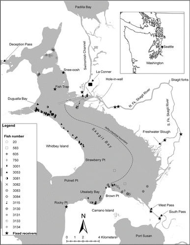
Skagit Bay (), located in northern Puget Sound, measures approximately 26 km long and varies in width from 3 to 8 km. Depths as great as 50 m are found in some bay locations; however, large intertidal areas, with maximum depths of less than 5 m are extensive. Surface waters in this area typically are warmer in summer (10–13°C) and cooler in winter (7–10°C; Collias et al. Citation1974). Other habitat data are available from Bailey et al. (Citation1998). The Swinomish Channel is a shallow, narrow, 12-km-long saltwater waterway with depths generally less than 10 m. For this paper we defined the channel as the area from the north, where it entered Padilla Bay, to the southwest end of the man-made jetty, where the channel enters Skagit Bay (Figures , ).
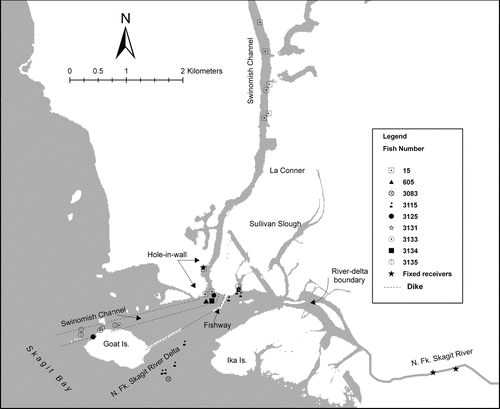
FIGURE 2 Map detail of bull trout detected in the Swinomish Channel and North Fork Skagit River delta, Washington, in 2006. Shown are data for fish that resided in the channel or delta for more than 7 d and for fish detected one or two times that migrated through this area. Symbols are not shown for eight fish that resided for more than 7 d in the Hole-in-Wall.
Tagging.—We captured 35 bull trout by angling in the lower Skagit River and by beach seining (36.6 × 3.7 m net) in the Swinomish Channel. Acoustic transmitters (Vemco, Inc., Shad Bay, Nova Scotia, Canada) were used to tag 20 fish captured near the confluence of the North and South forks from mid-March to early-April (river-tagged: RT) and 15 fish captured from the Swinomish Channel (channel-tagged: CT) from mid-May to mid-June 2006 (; Table A.1 in the appendix). Some fish smaller than 450 mm long were probably subadults (Kraemer Citation2003). An additional nine transmitters from fish studied (saltwater-tagged: SWT) in 2004 or 2005 by two of the authors (F. Goetz, E. Jeanes), using methods similar to those used in 2006, were also detected during our study (). Data from fish tagged in 2004–2005 whose status (dead or alive) could not be determined were not used in the analyses (Table A.1).
TABLE 1 Tagging year, nature of tagging site, and length data for bull trout detected in 2006. Lengths were collected during the tagging years indicated.
Captured fish were transferred to a 0.6 × 0.6 × 1.2 m live-tank and then to a container (87 L) filled with water and buffered tricaine methanesulfonate (MS-222). Each fish was measured (fork length [FL], nearest mm), weighed (nearest 1.0 g), and prepared for surgery to insert an acoustic transmitter. Four sizes of transmitters were used (V-8, V-9, V-13, and V-16) that permitted us to maintain a transmitter-to-fish weight ratio of less than 1%. Transmitters had a minimum life of 200 d and were programmed with a random pulse rate (30–90 s). In 2006, six of the transmitters also carried depth sensors.
The surgical procedures used to insert the transmitters followed previous studies (Summerfelt and Smith Citation1990; Adams et al. Citation1997; Fernet and O’Neil Citation1997; McCleod and Clayton Citation1997; BioAnalysts Citation2002; Muhlfeld et al. Citation2003). After anesthetization (∼90 s), fish were transferred to a surgical pad where the gills were continuously flushed with anesthetic (30–45 s) and then with fresh ambient water (30–45 s). Transmitters were placed into the body cavity directly below and parallel to a 10–20 mm incision. The incision was closed with interrupted, nonabsorbable sutures and a small amount of Vetbond glue. Each fish was maintained in the recovery tank for 4 h before being released. Surgical procedures averaged 90 s, from the time a fish lost equilibrium to the time it was placed into the recovery tank.
Acoustic tracking.—Fish positions were determined by using fixed receivers or by active relocation by boat. Four submersible receivers (Vemco, Model VR-2; hereafter-“lower river receivers”) were placed in the lower reaches of both the South (2) and North (2) forks of the Skagit River on March 13, 2006 (Figures , ). On April 10, 2006, a fifth receiver was placed in a deep-water section of the Swinomish Channel, named Hole-in-the-Wall (HIW; ). Additional position data were obtained from fixed receivers operated by the U.S. Army Corps of Engineers (USACE) at several bay and upriver locations (). Distances and time traveled by fish were based on detections at these receivers. To calculate distance traveled, we assumed each fish followed a path that reflected the shortest linear measurement to a detection site.
TABLE 2 Range testing of acoustic transmitters for two bottom slope–substrate classes in Skagit Bay, Washington. The maximum distances represent values from hydrophone to transmitter when the transmitter could be coded. Acoustic signals were monitored from a boat using a Vemco VH-65 directional hydrophone; the transmitters (Vemco) used in the tests were placed in perforated plastic containers that floated 0.6 m above the seafloor and were held in place by anchors. Distances are single values for one V-8 transmitter and mean values for two V-13 and two V-16 transmitters.
Fish surveys of the bay and channel were conducted during daylight hours on 65 weekdays from April through July, 2006. The entire bay perimeter was surveyed approximately every 2 weeks. Areas included all of the shoreline west of the delta-intertidal boundary from Deception Pass in the north to a line extending roughly from Polnell Point to Rocky Point in the south (). Partial surveys of the north and middle bay took place in July and in the south bay during early April and in July. Regular surveys omitted much of the area east of the intertidal boundary () between the North and South Fork outlets. However, in June, we surveyed this area by moving in a 500-m grid pattern; in July, the southwest portion was resurveyed. These surveys were completed during high-tide periods. Additional bay areas surveyed included 2 km of shoreline southeast of Brown Point and North Fork (Skagit River) delta habitats west of a line crossing the river approximately 1.6 km upstream of the fishway entering the Swinomish Channel (Figures , ). The Swinomish Channel was completely surveyed in the latter halves of May, June, and July. Surveys of Port Susan and the west shoreline of Camano Island in May and June were discontinued because few fish were detected.
We surveyed the bay perimeter by moving in 500-m increments. At each station we stopped the boat 300–500 m from the shoreline, turned off the motor and depth finder, and listened for transmitters by using a receiver (Sonotronics, Model USR-96) connected to an omni-directional hydrophone (Sonotronics, Model SH1). We used a directional hydrophone (Sonotronics, Model DH-4) to determine the compass bearing of each transmission and continued moving until the transmitter code could be identified (Vemco VR-60 receiver with a VH-65 directional or V-10 omni-directional hydrophone, or VR-28 receiver with a directional hydrophone array). If possible, we continued until the code could be recognized at a gain of no more than 24 decibels (dB). Boat positions were identified by using a global positioning system (gps), and final gain and compass bearing to the fish were recorded. Fish detections were categorized as being from bay or channel habitats, considering bay habitats as any Skagit Bay locations other than the Swinomish Channel.
We conducted tests to determine the accuracy of hydrophone-to-transmitter bearings and to determine the range (distance from hydrophone) at which we could identify a coded transmitter. Bearings were tested by using a V-16 transmitter placed at locations unknown to the observer and at distances within the detection range of the VH-65 hydrophone set to a gain of 48 db. Bearing estimates at distances of 300–500 m averaged ±14° of the true bearing (N = 8). Detection distance for different transmitter sizes and gains varied by depth and habitat (), but in general, larger transmitters were detected at greater distances (maximum range >800 m) than the smallest transmitters (maximum range 352 m). We used boat position as a proxy for fish position, but at the lowest gain we were probably less than100 m from a fish's true position.
We categorized fish detected at the lower river receivers as outmigrants (fish migrating from the river to Skagit Bay) or as returning migrants. Exit date for outmigrants was the last date a fish was identified on the lower river receivers. Return migrants were defined as fish detected in marine waters and later detected at the lower river receivers. Return date was the first date a fish was identified on the fixed receivers after detection in saltwater. The length of time fish resided in saltwater (saltwater residency) was calculated as the difference in days between exit and return dates.
Fish positions and habitat descriptions.—Summaries of fish positions and habitat descriptions were based on our best estimate of a fish's position during each “event.” An event was defined as a time period within a survey day when a transmitter code was detected. Detections separated by at least 2 h were considered separate events, typically where we detected the fish at the lowest gain. Detections separated by less than 2 h also qualified as separate events if they were at least a minimum distance apart. The minimum distance was based on range tests (), gain (≤24 dB or >24 dB), and transmitter size. For the V-8 transmitter, these distances were 157 and 352 m for the two different gain levels; for the V-13 and V-16 transmitters, the corresponding distances were 315 and 630 m and 435 and 843 m, respectively. Fish were categorized as bay or channel residents if the data suggested they occupied those areas for 7 or more days. Data collected from positions where fish appeared to be actively migrating between the bay and the river were not used to describe habitats.
Distance to shore was measured as the measurement between a fish position and the shore high-water mark (McBride et al. Citation2006). Depth of the water column was determined with an onboard sonar, or by using the fish position and a digital bathymetry map (Finlayson et al. Citation2000). All bathymetry measurements were corrected for tide height, based on a nearby tide station within 5 min of the time the position was determined. Habitat use by bay residents was determined with a modification of the minimum convex polygon technique (MMCP; Mohr Citation1947). This modification was necessary because of the limited number of detections for each fish, because of the inexact fish positions (i.e., boat positions used for fish positions), and because of the irregular nature of the shoreline. Boundaries for each MMCP were formed by describing a line connecting fish positions over water (the endpoints were the two points farthest apart from each other), the two shoreline points nearest the end points of the fish position line, and the shoreline contour between the two shoreline points. Length of utilized habitat was measured as the distance between the two most distant fish positions.
For bay residents, habitat descriptions included shoreline, substrate, and vegetation classes (McBride et al. Citation2006; Tables A.2–A.4). These data were available for the majority of bay perimeter and shallow water habitat but not for the Swinomish Channel. Substrate and vegetation data were available only within the intertidal zone; therefore, for a few fish, only portions of the MMCP could be described. Length or area data for each habitat class within MMCPs were converted to percentages and averaged, and an “unmapped” category was included when necessary. Similar mapped and unmapped categories were computed for the bay based on its entire shoreline length or surface area.
Statistical methods.—Correlation analysis (Sokal and Rohlf Citation1995) was used to test the relationship between fish length at tagging and return date or distance traveled to the MMCP (center of polygon). Mean fish length was compared by using t-tests, and summary statistics were used to describe habitat characteristics. We ranked habitat class preferences (Aebischer et al. Citation1993) by using a compositional analysis of selection (Leban Citation1999) to compare habitat use with habitat availability for bay residents. This analysis used each animal as the sampling unit; significant values of the test statistic (Wilk's lambda scores) indicated a departure from random use of the available habitat (Aebischer et al. Citation1993). Error estimates reported in the text with means refer to the standard deviation.
RESULTS
Saltwater Residency
All 20 RT fish from the Skagit River and 7 SWT fish were detected at the lower river receivers during March–May, 2006. Subsequent detections indicated 12 of the 20 RT fish continued downstream and entered Skagit Bay. Six of seven SWT fish that were detected with the lower river receivers in 2006 were also detected in saltwater. The out-migration date for the 18 fish that entered Skagit Bay ranged from March 17 to May 17 (mean = April 17 ± 18 d). Saltwater residency ranged from 36 to 133 d (mean = 75 ± 22 d) for 13 fish that were detected both when they exited and entered the Skagit River. Their return dates ranged from May 17 to July 28 (mean = June 28 ± 18 d). All 15 CT fish were detected and entered the river from June 10 to July 18 (mean = July 2 ± 19 d); however, these data were influenced by two of the smallest fish tagged (223 and 228 mm FL), which entered the river on August 19 and 22, respectively.
Saltwater Fish Detections
Overview.—We detected 34 transmitters (12 RT, 14 CT, and 8 SWT) from live fish in bay or channel locations. None of the fish tagged in 2006 were located outside of Skagit Bay.
Skagit Bay.—Twenty-one fish (11 RT, 4 CT, 6 SWT) were detected in Skagit Bay. Fourteen of the 21 fish were considered bay residents; the remaining 7 fish were detected only once or were found to be moving through the bay from other areas. The 14 residents were detected on a mean of six dates and eight fish positions. Although these fish were dispersed across the bay, 50% were detected near the north shore of Camano Island (). For residents detected while exiting the river, travel time to the bay was 15 ± 9 d (range 5–36 d, N = 12), whereas travel time from the bay to the river was 11 ± 10 d (range 1–33 d, N = 12). Residents were primarily detected at shoreline locations (Figures , ); however, some were detected for 1 or 2 days at intermediate locations during migrations between the river and the bay, primarily in the Swinomish Channel (HIW). Shoreline locations were less than 14 km from the Skagit River, and there was no relationship between fish length and the distance to a shoreline location (r = 0.06, P = 0.41, df = 10). Fish were commonly relocated near their previous detection site. The mean distance between successive detections was 0.9 ± 0.7 km and occasionally as great as 4.4 km, but we found no evidence that fish changed their primary location (e.g., moved from the south bay to the north bay) once they were established in the bay.
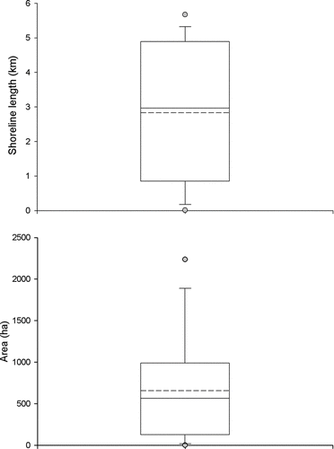
Bay residents were usually less than 0.4 km from the shoreline (83% of measurements) and 28% of detections were less than 100 m from shore (). Mean distance to shore was greater for 3 fish (0.7 ± 0.3 km) detected in an intertidal area east of Brown Point than for 10 fish from other bay locations (0.2 ± 0.1 km). Depth of the water column was typically less than 4 m, approximately 31% of the depths being 2.0 m or less (). Most fish were between the boat and the shoreline; because we used boat positions to estimate fish positions, we probably overestimated distance to shore and depth for many fish. Shoreline lengths of MMCPs ranged from 0.8 to 4.8 km and the total area used was typically less than 1,000 ha (). There was no relationship between mean shoreline length and number of detections (r = 0.35, P = 0.22, df = 12) or length of fish (r = 0.01, P = 0.98, df = 9).
FIGURE 3 Box plots of distance to shore and depth for 14 resident bull trout from Skagit Bay. Plots show the distribution of all values measured (N = 126) and mean values (N = 14) and describe the 25% (bottom line) and 75% (top line) percentiles, median (solid line inside box), mean (dashed line), whiskers (10th and 90th percentiles), and outliers (circles).
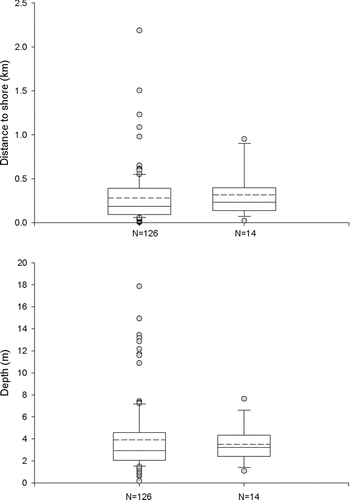
FIGURE 4 Box plots of shoreline length and area measured from modified minimum convex polygons used to describe habitat for 14 resident bull trout from Skagit Bay. Plots describe the 25% (bottom line) and 75% (top line) percentiles, median (solid line inside box), mean (dashed line), whiskers (10th and 90th percentiles), and outliers (circles).
Habitat class data () and compositional analysis () of MMCPs suggested that bull trout use of habitats was not random (P < 0.01). Coastal deposits, low bank, and sediment bluff accounted for nearly 76% (by length) of natural shoreline classes. These classes also ranked highest in use relative to other shoreline classes (). Modified and unmodified shoreline classes were used in proportion to their availability (P = 0.57); common modifications included concrete bulkhead and riprap. Green algae, eelgrass (Zostera sp.), and unvegetated were frequent vegetation classes within MMCPs (); combined, they made up more than 70% of the area used by bull trout. Use of spit-berm, salt marsh habitats, and green algae vegetation classes was greater than expected, based on availability, while the unvegetated class ranked low (). Mixed fines, mixed coarse, and sand made up 51% of MMCPs, the mixed fine substrate being highly ranked in comparison with its availability. In addition, two substrates that were uncommon in the bay, fines with gravel and mixed coarse, were highly ranked ().
TABLE 3 Mean percent by length or area for natural shoreline, modification, substrate, and vegetation classes in Skagit Bay and in modified minimum convex polygons used to define bull trout habitats. The count is the number of polygons that included each class; tr = a trace amount. The descriptions of the habitat classes are from McBride et al. (Citation2006).
TABLE 4 Ranking matrices of habitat compositional analysis for the natural shoreline, substrate, and vegetation classes determined from the modified minimum convex polygons used to define bull trout habitats in Skagit Bay for 2006. The signs indicate whether the habitat category in each row was used more (+) or less (–) than the habitat category in the corresponding column. Triple signs indicate significant differences (P < 0.05) between the two habitat categories; single signs indicate nonsignificant differences. The habitat categories were ranked in order of use (1 = least used).
Swinomish Channel.—We detected 22 fish in the channel: 14 CT fish, 4 RT fish, and 4 SWT fish. Ten fish (six CT, one RT, and three SWT) were considered residents (), two fish were detected briefly at Snee-oosh shortly after tagging (1–4 d) and thereafter only at the HIW site. Eight additional CT fish were detected at HIW on only one or two dates and shortly after were detected entering the river. Three RT fish and one SWT fish were detected on one or two dates in the channel and three of these fish were migrating to or from the bay.
Channel residents were detected on a mean of 12 d (range 3–27) and 14 (range 3–37) detection events. The majority (8 of 10) were found only in the HIW while the remaining 2 fish used other channel areas (). Mean residency time was 38 ± 23 d (range 10–81); however, this value was probably underestimated because CT fish were not tagged until May or June 2006. Mean residence time for three fish tagged in 2005 was 63 ± 15 d (range 53–81) compared with 24 ± 15 d (range 10–44) for seven fish tagged in 2006. Mean travel time from the channel to the river for channel residents was 1 ± 1 d (range 0–4, N = 8); however, the time for one additional fish (FL = 228 mm) was 32 d.
Shoreline lengths for eight channel residents that used the HIW site were no greater than 0.6 km. In comparison, length and mean distance between detection sites were 5.1 mm and 1.4 km and 0.6 mm and 0.3 km, respectively, for two residents detected outside the HIW (). Most channel residents were within 100 to 200 m of the shoreline; the maximum depth at HIW where most channel fish were detected was approximately 9 m, but some fish were detected at the margins in water judged to be less than 2 m in depth.
DISCUSSION
Saltwater Residency
Our data suggest that the marine habitats of Skagit Bay were used for extended periods of time (up to 133 d) by anadromous bull trout tagged in the lower Skagit River. Bull trout predominately entered the bay from March to May and reentered the river from May to August. These results agree with previous studies that showed marine residence from April to July for bull trout from Puget Sound rivers (Goetz et al. Citation2004, Citation2007) and were similar to the marine residence time of brook char in Quebec (90–150 d; Curry et al. Citation2006). In contrast, some subadult bull trout from the Hoh River (Washington) appeared to enter the Pacific Ocean from September to December (Brenkman et al. Citation2007), and Smith and Saunders (Citation1958) found that winter habitats included marine waters for brook char on Prince Edward Island. Consequently, the timing of marine residence could be more variable than indicated by our data. Because we monitored fish migration only from March to August, we would have missed detecting any fish that exited earlier, returned later, or reentered the bay in the fall. Further, one fish tagged before 2006 was detected by a fixed receiver at Rocky Point in January 2006, supporting reports that some bull trout may be found in Skagit Bay during any month (Goetz et al. Citation2004).
The duration of marine residency by bull trout was probably affected by several factors, including the seasonal availability of food resources (Mathisen and Berg Citation1968; Rikardsen et al. Citation2000) or water temperature. By mid-July, when most fish had returned to the Skagit River, surface water temperatures in the bay had increased 3°C to 5°C (unpublished data). Other variables that may influence the duration of saltwater residence include fish age, predation risk, or potential competition for spawning sites in the river. Return timing for adults could also be linked to maturation physiology as gonadal development may be incompatible with hypo-osmoregulation (Claireaux and Audet Citation2000); indeed, a required period of freshwater residence for in-year gonad development has been suggested for brook char (Curry et al. Citation2006). This hypothesis is supported by our finding that the two smallest fish (≤228 FL; probably subadults), returned to the river nearly a month later than did the other study fish; however, additional research is needed to determine the factors that prompt bull trout to return to the Skagit River.
Anadromy and Multiple Saltwater Migrations
We found that anadromy was common for bull trout captured and tagged during late winter–early spring from the lower Skagit River. According to our data, all tagged fish moved towards Skagit Bay and at least 60% of RT fish migrated into Skagit Bay. Similarly, two studies from the Hoh River have suggested anadromy rates ranging from 57% to 85% (Brenkman and Corbett Citation2005; Brenkman et al. Citation2007). A lower rate than observed in our study might be expected for the Skagit River population as a whole because we captured and tagged fish solely from the lower river (probable migrants) instead of a random sample of fish from throughout the river. In contrast, Hoh River fish were captured from both lower and upper river sites. Preliminary data indicate considerable life history variation within the Skagit River population, and many anadromous bull trout in the Skagit River may originate from the Sauk River, a glacial-fed tributary (Ed Conner, Seattle Power and Light, personal communication). Therefore, our data should not be used as a measure of anadromy for the entire Skagit basin and further research may reveal the extent of anadromy among Skagit River bull trout. Finally, the detection of several fish tagged in saltwater in previous years agreed with previous studies for bull trout (Brenkman et al. Citation2007) and other species of char (Arai and Morita Citation2005), showing that some fish make multiple seawater migrations.
Marine Distribution
We found bull trout at many of the shoreline areas in Skagit Bay. Two areas of concentration were the north shore of Camano Island and the Swinomish Channel. Common use of the channel may have been partly related to site fidelity, given that most fish using this area were captured and tagged in the channel either in 2006 or in previous years. However, one RT fish was a channel resident and other fish visited the area during migrations between the river and the bay. In addition, several study fish spent their entire marine residency in the channel. Goetz et al. (Citation2007) reported that this area was also used by several bull trout originally tagged in the Nooksack River (north of Skagit Bay). One area of Skagit Bay apparently not used by bull trout was the intertidal zone between the North and South forks; however, complete surveys of this area were limited to a few weeks in June.
The bull trout we studied appeared to travel only modest distances from the Skagit River during their marine phase (<12 km). None of the fish tagged in 2006 were found outside Skagit Bay and, although a few fish tagged in 2004–2005 were located in Port Susan, they were less than 15 km from the river mouth. We did not extensively survey distant areas and a few of our study fish were rarely or never contacted after tagging, so some fish may have migrated greater distances than we recorded; nevertheless, we were able to account for the location of most tagged fish. The distances traveled by our study fish were less than distances traveled by bull trout (47 km) in the Hoh River (Brenkman and Corbett Citation2005) or by a bull trout that traveled about 50 km between the Nooksack River and the Lower Fraser River (British Columbia; Kraemer Citation2003, cited in USFWS Citation2004). Similarly, Dolly Varden captured in marine waters off southeast Alaska were 13–60 km (median) from their release site in freshwater (Bernard et al. Citation1995), and Arctic char in Norway remained in marine areas within 30 km of the river mouth (Berg and Berg Citation1987; Berg and Jonsson Citation1990). In contrast, migration distances of 150 km for char from the Squamish River, British Columbia, to the Skagit River (McPhail and Baxter Citation1996) and 130 km for bull trout reported by Goetz et al. (Citation2004) suggest that some fish may travel greater distances. Further, migration distances of more than 1,600 km from the mainland are known for northern forms of Dolly Varden (DeCicco Citation1992).
Habitats
One behavior that was common among bull trout in marine waters was the use of shallow, nearshore habitats. In general, fish positions were within 400 m of the shoreline and shallower than 4 m; because we used boat positions as a proxy for fish positions and the fish were usually shoreward of the boat, these measurements were probably overestimated. Although some bull trout probably crossed sections of Skagit Bay with water depths greater than 10 m to reach the east shore of Whidbey Island, our detections never indicated that fish maintained positions in these deeper areas. Our results matched those for Arctic char that spent >90% of their time in water no more than 3 m deep (Rikardsen et al. 2007a, 2007b) and were similar to results showing that bull trout densities were greatest at depths of 2–5 m (Goetz et al. Citation2004).
Data from this study expand the current knowledge about the size of marine habitats used by bull trout. We found considerable variability in the length of shoreline used by bay fish (0.01–5.7 km), differences that may be attributable to several factors, including variation among individuals (Börger et al. Citation2006), sampling error, habitat differences among sites, resource availability (Dussault et al. Citation2005; Moyer et al. Citation2007), body size, and sex (Schoener and Schoener Citation1982; Kramer and Chapman Citation1999). The general pattern suggested that individual bull trout moved from the river to a discrete section of bay shoreline or the Swinomish Channel, stayed there for much of their marine residency, and then returned to the river. Exceptions to this pattern were short-term movements to other parts of the bay (e.g., briefly traveling from HIW to Snee-oosh in north bay), but we found no evidence of consistently nomadic behavior for any fish.
Our analysis suggested variable site fidelity between years: Some bull trout returned to areas near their original tagging site while other fish ranged more widely. However, some level of interannual site fidelity was always indicated. Fish originally captured and tagged in Port Susan were detected either in Port Susan or on the north shore of Camano Island, an area that was probably encountered during the initial migration to Port Susan. Similarly, fish originally captured from the east shore of Whidbey Island or from the Swinomish Channel were detected in those same general locations. Because bull trout appear to reliably return to the same areas, this behavior may be useful to managers wanting to protect marine habitats.
Our descriptions of substrate, vegetation, and shoreline classes in bull trout habitats are the first of this type and thus are valuable despite incomplete mapping. However, habitat preference data should be considered preliminary because the number of detections of some fish was small, our fish location data were imprecise, and preference may be related to other factors. For example, substrate preference (e.g., mixed fines or mixed coarse gravel) may have been related to bull trout selection for depths and areas where prey items are readily available. The finding that eelgrass was common in areas used by bull trout was not surprising because eelgrass is an important ecotype to a variety of marine fishes (Connolly Citation1994; Dean et al. Citation2000; Hughes et al. Citation2002) and could harbor forage species utilized by bull trout. Data from bay fish on the use of modified shorelines in Skagit Bay may have been influenced by the fact that some of the unmodified shoreline, particularly the shoreward edge of the extensive delta tide flats, is dewatered and unavailable at many tidal stages. Use of modified shorelines might indicate that bull trout and humans prefer the same habitat. As a speculative example, some shorelines modified by development (e.g., Utsalady Bay) may concentrate forage used by bull trout, and may have done so before the shoreline was modified. Clearly, the current level of shoreline development has not prevented bull trout from using this area. More detailed data are required to determine bull trout selection and intensity of use for specific habitats and to assess human impacts.
Future Studies
Additional research is required to better describe and understand the marine life history of bull trout. Recent developments in acoustic telemetry may allow more accurate and precise measurement of habitat use. For example, use of depth or temperature-sensitive transmitters and receiver arrays that triangulate transmitter locations would enable fish positions and habitat use to be described at a finer resolution than we were able to achieve. Such data would help increase our knowledge of the near-shore movements of bull trout, how specific habitats are utilized, and the influence of temperature on fish distributions and marine residency. Future work should also include additional tagging of smaller fish (<300 mm FL) because data from this study and others (Brenkman et al. Citation2007) suggest run-timing differences between subadults and adults or fish that have made a previous migration.
Information on other aspects of marine habitats of bull trout is also lacking (McPhail and Baxter Citation1996; USFWS Citation1999). Although anadromous behavior in char is probably related to food availability (Gross Citation1987; Hendry et al. Citation2004), the food habits of bull trout in marine waters are not well known. Additional research would also elucidate the habitat requirements of this species in comparison with that of other salmonids, including sea-run cutthroat trout Oncorhynchus clarkii clarkii, which also use nearshore environments. Better descriptions of available habitat, including detailed maps, also are needed to understand how and why certain habitats are used (Wildhaber and Crowder Citation1990; Gratwicke and Speight Citation2005). For example, data on temporal changes in salinity or temperature might help biologists understand the migration timing to and from saltwater and would assist managers in making sound biological recommendations.
ACKNOWLEDGMENTS
We would like to especially acknowledge the efforts of our Student Conservation Association interns, Tiffany Anders and Rae Mooney, who happily spent many long days in difficult conditions locating bull trout in Skagit Bay. We also recognize the efforts of Curt Kraemer, who helped to capture and tag many of the fish used in this study. Thanks also to Skagit River System Cooperative personnel, including Karen Wolf who assisted with GIS mapping and Rich Henderson and his staff who captured many of the fish studied. Debbie Reusser and Rachel Nehmer provided superior expertise and training in GIS mapping, Mary Moser (National Oceanic and Atmospheric Administration) loaned us telemetry equipment, and Mike Parsley (U.S. Geological Survey) assisted in planning use of a survey boat and provided much of the telemetry equipment. Finally, a special thanks to Rob Jackson for assistance in boat and trailer maintenance. This project was partially funded by the U.S. Geological Survey Coastal Habitats in Puget Sound (CHIPS) project. Reference to trade names does not imply endorsement by the U.S. Government.
Subject editor: Michelle Heupel, James Cook University, Queensland, Australia
Related Research Data
REFERENCES
- Adams , N. S. , Rondorf , D. W. , Evans , S. D. , Kelley , J. E. and Perry , R. W. 1997 . Effects of surgically and gastrically implanted radio transmitters on swimming performance and predator avoidance of juvenile Chinook salmon (Oncorhynchus tshawytscha) . Canadian Journal of Fisheries and Aquatic Sciences , 55 : 781 – 787 .
- Aebischer , N. J. , Robertson , P. A. and Kenward , R. E. 1993 . Compositional analysis of habitat use from animal radio-tracking data . Ecology , 74 : 1313 – 1325 .
- Arai , T. , Kotake , A. and Kitamura , T. 2005 . Migration of anadromous white-spotted charr Salvelinus leucomaenis, as determined by otolith strontium: calcium ratios . Fisheries Science , 71 : 731 – 737 .
- Arai , T. and Morita , K. 2005 . Evidence of multiple migrations between freshwater and marine habitats of Salvelinus leucomaenis . Journal of Fish Biology , 66 : 888 – 895 .
- Armstrong , R. H. 1974 . Migration of anadromous Dolly Varden (Salvelinus malma) in southeastern Alaska . Journal of the Fisheries Research Board of Canada , 31 : 435 – 444 .
- Bailey , A. , Berry , H. , Bookheim , B. and Stevens , D. 1998 . Probability-based estimation of nearshore habitat characteristics . Proceedings of Puget Sound Research Conference, Seattle , Available: www.dnr.wa.gov/Publications/aqr_nrsh_hab_estimate98.pdf. (May 2010)
- BC Conservation Data Centre . 2010 . BC species and ecosystems explorer , Victoria : British Columbia Ministry of Environment . Available: www.env.gov.bc.ca/atrisk/toolintro. (April 2010)
- Beamer , E. , Henderson , R. and Wolf , K. 2004 . Bull trout use of Swinomish Reservation waters , La Conner , Washington : Skagit River System Cooperative . Available: www.skagitcoop.org/documents./ (November 2007)
- Berg , O. K. and Berg , M. 1987 . Migrations of sea trout, Salmo trutta L., from the Vardnes River in northern Norway . Journal of Fish Biology , 31 : 113 – 121 .
- Berg , O. K. and Jonsson , B. 1990 . “ Migratory pattern of anadromous Atlantic salmon, brown trout and Arctic charr from the Vardnes River in northern Norway ” . In Proceedings of the salmonid migration and distribution symposium , Edited by: Brannon , E. and Jonsson , B. 106 – 115 . Seattle : University of Washington .
- Bernard , D. R. , Hepler , K. R. , Jones , J. D. , Whalen , M. E. and McBride , D. N. 1995 . Some tests of the “migration hypothesis” for anadromous Dolly Varden (southern form) . Transactions of the American Fisheries Society , 124 : 297 – 307 .
- BioAnalysts . 2002 . Movement of bull trout within the mid-Columbia River and tributaries, 2001–2002 , Wenatchee , Washington : Prepared for Chelan County PUD by BioAnalysts .
- Börger , L. , Franconi , N. , De Michele , G. , Gantz , A. , Meschi , F. , Manica , A. , Lovari , S. and Coulson , T. 2006 . Effects of sampling regime on the mean and variance of home range size estimates . Journal of Animal Ecology , 75 : 1393 – 1405 .
- Brenkman , S. J. and Corbett , S. C. 2005 . Extent of anadromy in bull trout and implications for conservation of a threatened species . North American Journal of Fisheries Management , 25 : 1073 – 1081 .
- Brenkman , S. J. , Corbett , S. C. and Volk , E. C. 2007 . Use of otolith chemistry and radiotelemetry to determine age-specific migratory patterns of anadromous bull trout in the Hoh River, Washington . Transactions of the American Fisheries Society , 136 : 1 – 11 .
- Brenkman , S. J. , Larson , G. L. and Gresswell , R. E. 2001 . Spawning migration of lacustrine-adfluvial bull trout in a natural area . Transactions of the American Fisheries Society , 130 : 981 – 987 .
- Claireaux , G. and Audet , C. 2000 . Seasonal changes in the hypo-osmoregulatory ability of brook charr: the role of environmental factors . Journal of Fish Biology , 56 : 347 – 373 .
- Collias , E. E. , McGary , N. and Barnes , C. A. 1974 . Atlas of physical and chemical properties of Puget Sound and its approaches , Seattle : University of Washington Press .
- Connolly , R. M. 1994 . A comparison of fish assemblages from seagrass and unvegetated areas of a southern Australian estuary . Australian Journal of Marine and Freshwater Research , 45 : 1033 – 1044 .
- Curry , R. A. , van de Sande , J. and Whoriskey , F. G. Jr . 2006 . Temporal and spatial habitats of anadromous brook charr in the Laval River and its estuary . Environmental Biology of Fishes , 76 : 361 – 370 .
- Dean , T. A. , Haldorson , L. , Laur , D. R. , Jewett , S. C. and Blanchard , A. 2000 . The distribution of nearshore fishes in kelp and eelgrass communities in Prince William Sound, Alaska: associations with vegetation and physical habitat characteristics . Environmental Biology of Fishes , 57 : 271 – 287 .
- DeCicco , A. L. 1992 . Long-distance movements of anadromous Dolly Varden between Alaska and the U.S.S.R . Arctic , 45 : 120 – 123 .
- Dussault , C. , Courtois , R. , Ouellet , J. and Girard , I. 2005 . Space use of moose in relation to food availability . Canadian Journal of Zoology , 83 : 1431 – 1437 .
- Fernet , D. A. and O’Neil , J. 1997 . “ Use of radio telemetry to document seasonal movements and spawning locations for bull trout in relation to a newly created reservoir ” . In Friends of the bull trout conference proceedings, bull trout task force (Alberta) , Edited by: Mackay , C. W. , Brewin , M. K. and Monita , M. 427 – 434 . Calgary , , Canada : Trout Unlimited .
- Finlayson , D. P. , Haugerud , R. A. , Greenberg , H. and Logsdon , M. G. 2000 . Puget Sound digital elevation model . Available: www.ocean.washington.edu/data/pugetsound. (October 2000)
- Fraley , J. J. and Shepard , B. B. 1989 . Life history, ecology and population status of migratory bull trout (Salvelinus confluentus) in the Flathead Lake and river system, Montana . Northwest Science , 63 : 133 – 143 .
- Goetz , F. A. , Jeanes , E. and Beamer , E. 2004 . Bull trout in the nearshore , Seattle : U.S. Army Corps of Engineers, preliminary draft (June) .
- Goetz , F. , Jeanes , E. and Morello , C. 2007 . Puget Sound bull trout migration and habitat use study, Nooksack River and estuary and northeast Puget Sound nearshore. Progress report prepared for the U.S , Fish and Wildlife Service, Interagency Agreement 13410-6-H001 . by the U.S. Army Corps of Engineers, Seattle, and R2 Resource Consultants, Redmond, Washington
- Gratwicke , B. and Speight , M. R. 2005 . The relationship between fish species richness, abundance and habitat complexity in a range of shallow tropical marine habitats . Journal of Fish Biology , 66 : 650 – 667 .
- Gross , M. 1987 . “ Evolution of diadromy in fishes ” . In Common strategies of anadromous and catadromous fishes , Edited by: Dadswell , M. J. , Klauda , R. J. , Moffitt , C. M. , Saunders , R. L. , Rulifson , R. A. and Cooper , J. E. 14 – 25 . Bethesda , Maryland : American Fisheries Society, Symposium 1 .
- Haas , G. R. and McPhail , J. D. 1991 . Systematics and distributions of Dolly Varden (Salvelinus malma) and bull trout (Salvelinus confluentus) in North America . Canadian Journal of Fisheries and Aquatic Sciences , 48 : 2191 – 2211 .
- Hendry , A. P. , Bohlin , T. , Jonsson , B. and Berg , O. K. 2004 . “ To sea or not to sea? Anadromy versus non-anadromy in salmonids ” . In Evolution illuminated , Edited by: Hendry , A. P. and Stearns , S. C. 92 – 125 . New York : Oxford University Press .
- Hughes , J. E. , Deegan , L. A. , Wyda , J. C. , Weaver , M. J. and Wright , A. 2002 . The effects of eelgrass habitat loss on estuarine fish communities of southern New England . Estuaries , 25 : 235 – 249 .
- Kraemer , C. 2003 . Management brief: Lower Skagit bull trout: age and growth information developed from scales collected from anadromous and fluvial char , Olympia : Washington Department of Fish and Wildlife .
- Kramer , D. L. and Chapman , M. R. 1999 . Implications of fish home range size and relocation for marine reserve function . Environmental Biology of Fishes , 55 : 65 – 79 .
- Leban , F. 1999 . Resource selection for Windows 1.0 . Available: www.cnrhome.uidaho. edu fishwild /Garton/tools. (March 2011)
- Mathisen , O. A. and Berg , M. 1968 . Growth rates of the char, Salvelinus alpinus (L.) in the Vardnes River, Troms, northern Norway . Report of the Institute of Freshwater Research Drottningholm , 48 : 177 – 186 .
- McBride , A. , Wolf , K. and Beamer , E. 2006 . Skagit Bay nearshore habitat mapping , La Conner , Washington : Skagit River System Cooperative, EB2180 . Available: www.skagitcoop.org/documents./ (November 2006)
- McCleod , C. L. and Clayton , T. B. 1997 . “ Use of radio telemetry to monitor movements and locate critical habitats for fluvial bull trout in the Athabasca River, Alberta ” . In Friends of the bull trout conference proceedings , Edited by: Mackay , C. W. , Brewin , K. and Monita , M. 413 – 420 . Canada : Trout Unlimited, Calgary .
- McPhail , J. D. and Baxter , J. S. 1996 . A review of bull trout (Salvelinus confluentus) life-history and habitat use in relation to compensation and improvement opportunities , Vancouver : University of British Columbia, Fisheries Management Report 104 .
- Mogen , J. T. and Kaeding , L. R. 2005 . Identification and characterization of migratory and nonmigratory bull trout populations in the St. Mary River drainage, Montana . Transactions of the American Fisheries Society , 134 : 841 – 852 .
- Mohr , C. O. 1947 . Table of equivalent populations of North American small mammals . American Midland Naturalist , 37 : 223 – 249 .
- Moyer , M. A. , McCown , J. W. and Oli , M. K. 2007 . Factors influencing core-area size of female Florida black bears . Journal of Mammalogy , 88 : 468 – 476 .
- Muhlfeld , C. C. , Glutting , S. , Hunt , R. , Daniels , D. and Marotz , B. 2003 . Winter diel habitat use and movement by subadult bull trout in the upper Flathead River, Montana . North American Journal of Fisheries Management , 23 : 163 – 171 .
- Pacific International Engineering . 2008 . Skagit River Basin hydrology report: existing conditions , Washington : Report to City of Burlington, City of Mount Vernon, Dike, Drainage and Irrigation District 12, Dike District 1 . Available: www.ci.burlington.wa.us. (January 2011)
- Rice , C. A. 2006 . Effects of shoreline modification on a northern Puget Sound beach: microclimate and embryo mortality in surf smelt (Hypomesus pretiosus) . Estuaries and Coasts , 29 : 63 – 71 .
- Rikardsen , A. H. , Amundsen , P. A. , Bjorn , P. A. and Johansen , M. 2000 . Comparison of growth, diet and food consumption of sea-run and lake-dwelling Arctic charr . Journal of Fish Biology , 57 : 1172 – 1188 .
- Rikardsen , A. H. , Dempson , J. B. , Amundsen , P. , Bjorn , P. A. , Finstad , B. and Jensen , A. J. 2007a . Temporal variability in marine feeding of sympatric Arctic charr and sea trout . Journal of Fish Biology , 70 : 837 – 852 .
- Rikardsen , A. H. , Diserud , O. H. , Jensen , A. J. , Elliott , J. M. , Dempson , J. B. and Sturlaugsson , J. 2007b . The marine temperature and depth preferences of Arctic charr (Salvelinus alpinus) and sea trout (Salmo trutta), as recorded by data storage tags . Fisheries Oceanography , 16 : 436 – 447 .
- Schoener , T. W. and Schoener , A. 1982 . Intraspecific variation in core-area size in some Anolis lizards . Ecology , 63 : 809 – 823 .
- Smith , M. W. and Saunders , J. W. 1958 . Movements of brook trout, Salvelinus fontinalis (Mitchill) between and within fresh and salt water . Journal of the Fisheries Research Board of Canada , 15 : 1403 – 1449 .
- Sokal , R. R. and Rohlf , F. J. 1995 . Biometry , New York : Freeman .
- Suckley , G. 1861 . “ Report upon the fishes collected in the survey, chapter I, report upon the Salmonidae ” . In The natural history of Washington Territory on the survey of the Northern Pacific railroad route , 308 – 349 . New York : Bailliere Brothers .
- Summerfelt , R. C. and Smith , L. S. 1990 . “ Anesthesia, surgery, and related techniques ” . In Methods for fish biology , Edited by: Schreck , C. B. and Moyle , P. B. 213 – 272 . Bethesda , Maryland : American Fisheries Society .
- Thiesfeld , S. L. , Stuart , A. M. , Ratliff , D. E. and Lampman , B. D. 1996 . Migration patterns of adult bull trout in the Metolius River and Lake Billy Chinook, Oregon , Portland : Oregon Fish and Wildlife, Information Report 96-1 .
- USFWS (U.S. Fish and Wildlife Service) . 1999 . Endangered and threatened wildlife and plants: determination of threatened status for bull trout in the coterminous United States . Federal Register , 64 : 210 (1 November 1999):58909–58933
- USFWS (U.S. Fish and Wildlife Service) . 2004 . Draft recovery plan for the Coastal-Puget Sound distinct population segment of bull trout (Salvelinus confluentus), volume I: Puget Sound management unit. U.S , Portland , Oregon : Fish and Wildlife Service .
- White , H. C. 1941 . Migrating behavior of sea-running Salvelinus fontinalis . Journal of the Fisheries Research Board of Canada , 5 : 258 – 264 .
- Wildhaber , M. L. and Crowder , L. B. 1990 . Testing a bioenergetics-based habitat choice model: bluegill (Lepomis macrochirus) responses to food availability and temperature . Canadian Journal of Fisheries and Aquatic Sciences , 47 : 1664 – 1671 .
- Williams , G. D. and Thom , R. M. 2001 . Marine and estuarine shoreline modification issues , White paper submitted to the Washington Department of Fish and Wildlife, Washington Department of Ecology and Washington Department of Transportation . Available: www.wdfw.wa.gov/hab/ahg/finalsl.pdf. (April 2010)
- WSCC (Washington State Conservation Commission) . 2003 . Salmon and steelhead habitat limiting factors, water resource inventory areas 3 and 4, the Skagit and Samish basins , Washington : Lacey .