
Abstract
Urban plannings and design processes, through land management, are important factors that significantly influence the distribution of urban green lands (UGLs), and thus, the provision of ecosystem services (ESs), thereby providing opportunities for managing climate adaptation processes at the local level. However, planning for UGLs is often secondary to other planning categories, and they often remain underutilized. Through an analysis of Master Plans of major urban centres in Serbia and Bulgaria, this paper discusses the conceptualization of UGLs and the integration of ESs in planning and design processes. Based on findings obtained through an Analytical Hierarchy Process, this paper develops a conceptual framework for linking ESs with different UGL types in the course of urban planning, in order to achieve a better application of UGLs in strategies for the amelioration of micro-climatic conditions in urban areas. This paper proposes framework for an ecosystem sensitive conceptualization of UGLs in planning and design process, where UGL typology should replace functional categories, and spatial indicators are defined in relation to UGL types. Such an approach can improve the understanding and ES-sensitive application of UGLs in planning processes and local adaptation strategies.
1. Introduction
Urban agglomerations are complex human-natural systems in which people as a dominant agent continually transform natural landscapes, creating a new set of ecological conditions by changing ecosystem processes and dynamics (Alberti Citation2008). Although urban development patterns have immediately visible impacts on the local environment and ecosystems, they also have implications for environmental changes on a larger scale, principally, climate change (CC). Growing scientific agreement on global warming is unambiguous: each of the last three decades has been successively warmer (Couldrey & Herson Citation2008; Stocker et al. Citation2013), with CO2 emission doubling since 1970 (IEA Citation2009). If this trend continues, CO2 emission will increase by 50% by the middle of the century, bringing about an increase in average temperatures of up to 4 °C as compared to the beginning of the twentieth century, resulting in an increase in the frequency of extreme natural events such as floods, droughts and heat waves (IEA Citation2009).
The scientific consensus on the links between urbanization processes and CC has been growing steadily (OECD Citation2010). The degree of vulnerability and the impact of CC is largely dependent on the spatial composition and design of urban areas (EEA Citation2012, Citation2016). Nevertheless, despite the fact that it has been recognized that timely and long-term planning allows for more efficient and economically sound solutions vis-à-vis inevitable extreme natural events (Metz et al. Citation2007; OECD Citation2008), there are still gaps when it comes to practical tools and the applied institutional dimensions of urban planning and management in coping with climate-induced risks (Lankao & Qin Citation2011; Beermann et al. Citation2016). CC-related challenges are often most prominent in the local context (Gupta et al. Citation2007a, Citation2007b; Massetti et al. Citation2007). Considering the central role played by local governments in managing urban areas (Evans et al. Citation2005; Krueger & Agyeman Citation2005), many commentators on CC perceive regional, metropolitan and local levels of government as the most suitable levels for adaptation initiatives and programs (Ruth Citation2006; Linstroth & Bell Citation2007).
In recent years, nature-based solutions and improved green infrastructure are being increasingly put forward as more sustainable and cost-effective solutions for adaptation to CC than physical infrastructure, especially at the local level (EUC Citation2009, Citation2014; EEA Citation2011a; MAES 2016). Many studies highlight the profound capacity of UGLs to ameliorate microclimates in urban settings (e.g. Luber & McGeehin Citation2008; Bowler et al. Citation2010), by: decreasing air temperature (Spronken-Smith & Oke Citation1998; Hamada & Ohta Citation2010; Chen et al. Citation2013) and solar radiation (Givoni et al. Citation2003); regulating humidity (Ridgwell et al. Citation2009; Zhang et al. Citation2013); and sequestering CO2 (Novak et al. Citation2010; Dimitrova & Zhiyanski Citation2011; Zhiyanski et al. Citation2011). What is more, urban vegetation removes many pollutants from the air, water, and soil, serving at the same time as dispersion corridors for flora and fauna and contributing to higher biodiversity in cities (Yang et al. Citation2005; Nowak et al. Citation2006; Heidt & Neef Citation2008), even in the case of small urban green spaces (Meyer Citation1997).
However, in a rapidly urbanizing world, urban ecosystems and landscapes experience increased fragmentation, constantly competing in policy prioritization with other urban systems such as transportation or communal infrastructure (Geneletti Citation2004; Lafortezza et al. Citation2008). Integrated planning of UGLs – through improvement of their functional and spatial integrity – is seen as a way of optimizing delivery of ESs across a range of spatial scales (Forest Research Citation2010) and increasing the ability of UGLs to ameliorate CC effects in cities (Grimm et al. Citation2008). In everyday practice, treatment of UGLs and their spatial arrangement – and thus the provision of ESs – is largely influenced by local urban planning and design frameworks, and the regulatory environment; more precisely, UGLs are defined through systems of locally defined planning and design indicators.
As identified by Davies et al. (Citation2006), all types of open spaces, including parks, woodlands, tree-lined streets, and gardens, linked in a larger network, comprise an environmental resource, and provide significant opportunities for managing adaptation processes at the local level. However, UGLs are often implemented in phases at smaller spatial levels (e.g. the level of the building lot, neighbourhood) and shaped through design indicators, which, if followed without regard to other factors, can lead to erosion of larger UGL systems (Milutinovic et al. Citation2013). A lack of indicators for the planning and design of UGLs that take into account ESs makes it difficult to grasp the capacities of existing or planned UGLs to provide particular services. These methodological constraints can be seen as a cumulative risk, leading to inadequate utilization of UGLs and decreasing their capacity to ameliorate the effects of CC at the local level.
Recognition of the importance of the links between ESs and urban planning and design indicators for UGLs presents a case for them to be integrated into planning and design process. Nevertheless, there remains a lack of research into this link. The reason for this is, on the one hand, a lack of inventories of urban planning and design, few ES indicators, and, on the other hand, the great number and diversity of individual local mapping approaches. The selection of approaches and methods for mapping ESs depends on a number of factors such as: the availability of human resources; the complexity of sampling; the length of observation of a given ecosystem; the availability of data on the observed ecosystem, such as climate, soil, hydrological, topographical or land cover data; and other factors.
Along these lines, the aim of this paper is to propose a framework for connecting, analysing, and developing a link between, on the one hand, urban green land (UGL) planning and design indicators, and on the other, ecosystem services (ESs), focusing on regulating services, using major Serbian and Bulgarian cities as case studies. This will be achieved by addressing the following objectives:
| (1) | Identifying common types and approaches for the conceptualization of UGLs being used in the official Master Plans (“MPs”) of major cities in Serbia and Bulgaria. | ||||
| (2) | Describing a conceptual framework for linking common UGL types and their ESs. | ||||
| (3) | Providing directions for future research, and further improvement of this framework. | ||||
2. Methods
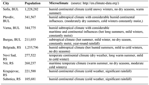
Firstly, this paper analyses major cities in Serbia and Bulgaria to identify common UGL types and approaches for their definitions based on indicators and categories being used for their planning and designing. The analysis relies on MPs of select cities (Figure .) as official planning and design documents. For identification of common UGL types, we used satellite images of each city. The selection of cities was based on two criteria: (1) the size of the urban area; we focused on the largest cities, and (2) climate; we selected cities that represent different climatic conditions. As shown in Figure , we sampled nine cities in total.
Figure 1. List of selected cities.
Based on our findings we proposed a framework for linking UGLs and ESs with indicators for planning and design, and exemplify its application using the example of ecosystem regulating services (ERs).
Secondly, through a literature review we identified four basic ERs related to climate amelioration and indicators that define them. In total, we identified 18 indicators (Figure ). In order to verify selected criteria and indicators, we conducted expert-based approval assessments. The goal of this step was to select relevant indicators for the given criteria. In total, we selected ten experts from the field of forestry and related disciplines who received assessment forms by email. Given that full consensus in group decision-making is often hard to achieve (Regan et al. Citation2006), the assessments were performed and results presented using a scale. Each expert was asked to assign a grade to each indicator as follows: 0 – for an indicator not relevant to a given criteria; 1 – for an indicator relevant to a given criteria; and 2 – for an indicator very relevant to a given criteria. The sums of the grades were subsequently combined and final grades were presented using the same scale.
Thirdly, UGL types that we identified in planning and design documents and selected ERs indicators are structured in a hierarchical model based on application of the Analytical Hierarchy Process (“AHP”) ranking developed by Saaty (Citation1977, Citation1980). The objective was to rank ERs with regards to UGLs. We found the AHP method useful for this type of model when there are no representative empirical or statistical data. The method is based on a hierarchical analysis, where the given problem is decomposed into elements of a hierarchy structured in levels. The elements are organized in line with the main objective into criteria, sub-criteria and their respective levels, with alternatives as the lowest level. The AHP aims at quantifying relative priorities of a given set of alternatives on a ratio scale, taking into account both the intuitive judgement of an expert and the consistency of the comparison of alternatives among experts. The application process of the AHP method is based on the concept proposed by Vinod Kumar and Ganesh (Citation1996):
| (1) | A hierarchical decomposition of the problem to be solved with the aim at the highest level, the criteria and sub-criteria at lower levels, and the alternatives at the lowest level. | ||||
| (2) | Comparison of pairs of elements in each level of the hierarchy in relation to the elements of the higher level, through application of the Saaty scale from 1 to 9 (Saaty & Vargas Citation1994). The expert determines the value aij, of the elements i and j, where aij = 1/ aij, i, j = 1…n and aij = 1, i = j. | ||||
| (3) | Setting priorities for each element in relation to a higher authority – wij is a priority of the alternative i in relation to the criteria j, where i = 1, …, m, j = 1, … , n, and m is the number of alternatives, and n is the number of criteria. | ||||
| (4) | Synthesis of all values of priorities so as to obtain the priority of each element in relation to the objective. Wi is the alternative priority i and it is determined as: | ||||
where, cj is the criteria priority j, and wij is the alternative priority i in relation to criteria j.
Following this method, we structured a model in hierarchical levels with the main objective of ranking ERs indicators with regards to UGLs. Three forestry experts from the Forest Research Institute-BAS (Figure ) performed ranking exercises (pairwise comparisons), and resultant values were processed in MS Excel for computing the final weight of each element in the hierarchy. The experts showed consistency in their ranking, with a satisfactory consistency ratio index CR (CR < 0.1).
3. Results
The Bulgarian and Serbian cities within the analysed MPs recognize UGLs as a part of planning and designing processes. Treatment of UGLs in MPs differs case-by-case, but common to all MPs is the absence of an overarching conceptual framework for UGL definition. UGLs are often subordinated to other planning domains – i.e. often defined as a supporting function of other planning categories (e.g. transportation, industry) – and thus there exists inconsistency in the categories of, and indicators for, the planning of UGLs among the analysed cities. MPs commonly use either functional or spatial approaches for definition of categories and indicators of UGLs.
3.1. Functional approach
MPs frequently employ a functional approach in the definition of categories of UGLs. By the functional approach what is meant is the definition of UGLs according to their function in relation to other planning categories, where UGLs are of secondary priority in planning and design. Some examples includes street landscaping and transportation, cementeries, green areas for sport, recreation and entertainment, buffer zones or UGLs in residential areas (Figure .) Consequently, MPs highlight likely planning challenges and developmental approaches. For example, higher risk of competition for water between consumption in suburban neighbourhoods and consumption for greenery irrigation in the urban centre in the municipality of Maritsa (in Bulgaria’s Plovdiv region) affects groundwater levels, and adversely affects land fertility in suburban areas. The MP for the Bulgarian capital Sofia would require more studies and exploratory work to bring about an improvement of its UGLs in terms of the management and social services it can provide. From an economic perspective, the touristic Bulgarian cities of Burgas and Varna have been aiming at better incorporation of UGLs with other urban systems, and have been focused on creating more public green spaces, improving spatial aesthetics and city identity, air quality, the micro-climate and sanitary conditions, with the hope of expanding their facilities for rest and relaxation, thereby achieving a positive effect on the local economy.
Figure 2. Categories and planning and design indicators of UGLs.
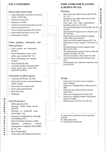
In broader terms, this approach recognizes three functional UGL groups: (1) green areas used in socio-economic activities; (2) utility green areas; and (3) natural parks and forests where UGLs have primary planning priority (e.g. urban forest areas, plantations, marshland etc.). The functional approach recognizes three UGL types: dense urban forest land, gardens and allotments, and grasslands in urban regions. MPs only tend to refer to the ES functions of UGLs by referring to utility green areas (e.g. purification of air and water), and they do not recognize finer differentiations of ESs.
3.2. Spatial approach
MPs use the spatial approach more frequently for the definition of UGL indicators. By the spatial approach what is meant is the definition of UGL indicators with regards to planning and design at the spatial level (Figure ). Using the spatial level as a common denominator, MPs recognize two main groups of indicators: (1) UGLs within the urban core, with finer subdivisions according to the type of spatial level (e.g. green area/district, micro region, building lots), and (2) peri-(sub)-UGLs. Indicators for planning are more suited to higher spatial levels, while design indicators are oriented more towards lower spatial levels, and less defined in terms of UGL categories.
In addition to the main division, the MPs for the cities selected for this paper provide further indicators in relation to a number of defined categories of UGLs (e.g. recreational green area/district, micro-region, building lots). As such, cities with more categories usually have more sub-indicators. For instance, the MPs for Sofia contain indicators such as: urban green areas for recreation and general use per capita (m2/per capita); and peri-urban green areas for recreation and general use per capita (m2/per capita); or in the case of Varna’s MPs, indicators such as: public green areas within an urban area; complimentary green system; and specialized green space per capita (in ha and m2/per capita). The consistency in application of this approach varies case-by-case.
By way of example, Burgas has made an attempt to introduce more complex spatial indicators, such as a green area proximity indicator. This indicator measures the availability of UGLs that can be reached within approximately 10 min by foot. The Burgas MP includes an approximation of the percentage of the population that lives within a one-kilometre walking distance to at least one of the city’s major parks. While this indicator demonstrates an inclination towards understanding accessibility to cultural and environmental ESs, the MPs did not go beyond a spatial description in this case.
3.3. Local climate and UGLs
Despite differences in the local climates of the selected cities, which vary from subtropical to humid continental (Figure .) – with the accompanying differences in precipitation patterns and weather conditions – climate is not officially recognized as an important planning or design factor in the MPs that were analysed. As a consequence, climate adaptation terminology and relevant planning tools are not present in these MPs. Though UGLs (and their ESs) are key to climate-sensitive planning, and one of the most often recommended solutions in adaptation strategies, the MPs that were analysed do not recognize the potential of UGLs in those terms. Some MPs (e.g. that of Sofia) recognize the importance of climate-sensitive planning of UGLs, but do not offer structured guidelines or other planning tools in that respect. As such, climate-sensitive planning of UGLs remains on the level of recommendations and UGLs are yet to be conceptualized and designed within the climate adaption concept.
3.4. Framework for linking UGLs indicators for planning and design with ES
The previous sections discussed how UGLs are defined by numbers of categories and indicators for planning and designing (Figure ) determined by contextual factors. The only properties considered in indicators and categories are UGL quantitative distribution and functional classification. Taken alone, because they provide an incomplete picture, each of these aspects is insufficient to explain the qualitative properties of UGLs and their links with the potential provision of ESs, and thus, the capacity of particular UGL types to affect micro-climates. Such a system of indicators and categories does not allow practitioners to make ES-sensitive decision in planning and design processes.
Considering the foregoing, and supporting EEA calls for spatially explicit delivery of ESs through strategically planned networks of high-quality green spaces (EEA Citation2011a), this section proposes a conceptual framework for linking ESs with indicators for the planning and design of UGLs (Figure ).
Figure 3. Framework for linking UGLs and ESs.
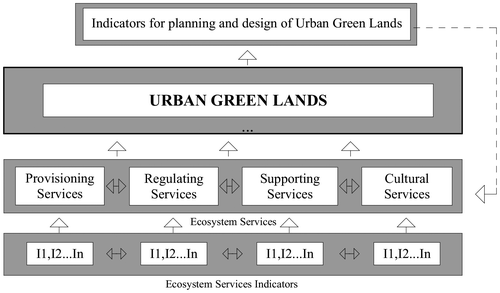
The proposed framework is built upon a hierarchical structure and aims to define the steps by which ES indicators can contribute to the conceptualisation of indicators for the planning and design of UGLs. It consists of four main blocks. Each block, and elements within the block, has an influence on the on the next one up, contributing to its properties. Abandoning the functional approach as a starting point, this framework classifies UGLs as a priority planning category, and recognizes the importance of positioning UGL types in relation to their capacity to deliver specific ESs, as the central concept in the definition of indicators for planning and design. This reflects our position that an understanding of the priority of ES indicators – which contribute to the provision of specific ESs – can inform the definition of UGL planning and design indicators. Indicators defined through this framework should offer practitioners information on the priority features of UGLs to be considered in planning and design processes for any given UGL design scenario and expected priority service (e.g. micro-climate regulation).
3.5. Linking ERs with UGLs using AHP
In reality, ESs are interlinked and approaching a single ES in an isolated fashion runs the risk of disregarding the possible effects from, and interactions with, other ESs Norgaard (Citation2010). With this in mind, we applied this framework only as an illustration of how ERs, can, for example, be used to define sets of indicators, which are informed and supported by accessible data sets on a national level. The AHP ranking method was used to prioritise ERs indicators.
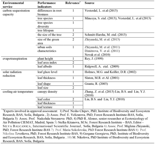
Figure details ERs and relevant indicators selected for this example. While we are aware that the number of ERs and indicators is greater, through our literature review we identified four ERs and eighteen indicators. An expert approval assessment exercise confirmed all four ERs as important for micro-climate regulation. It also confirmed most of the selected indicators, and thus, for a pairwise comparison exercise we adopted all the suggested ERs and indicators.
Figure 4. Exemplary ecosystem regulating services and relevant indicators.
Following the AHP method, the problem is structured into four hierarchical levels. The first level presents the key objective – ranking ER indicators in relation to UGL types. The second level consists of the main criteria – UGL types (those identified in the analysis of MPs). The third level sets out sub-criteria, the ER; and the fourth level comprises alternatives, namely, the ER indicators (Figure ).
Figure 5. Hierarchical structure of UGL types, ER, and ER indicators.
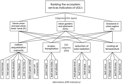
Figure , sets out the problem structure based on adopted elements from the previous analysis (UGL types, ER, indicators). Initially, the experts conducted a pairwise comparison of UGL types. They then conducted a pairwise comparison of sub-criteria, analysing how they contribute to the capacity of specific UGL types to ameliorate micro-climates. Subsequently, they conducted a pairwise comparison of local priorities, ranking alternatives (indicators) according to the degree to which they contribute to specific ER. The calculated values of the resulting vector of priorities W for each element in the hierarchy are shown in Figure . This vector represents the relative priority of the given criteria on the ratio scale.
Figure 6. Ranking priorities of UGL types, ER and indicators.
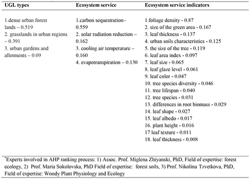
UGLs are differentiated in relation to the types of land cover and utilisation which are associated with different supply levels of ESs. The results of the comparison highlight that the highest priority among UGL types is dense urban forest land (W = 0.519). This means that dense urban land has the highest importance in provisioning ESs as compared to the two other UGL types. Many studies highlight high capacity of urban forests to provide a variety of ESs to city-dwellers, such as air purification, global climate regulation, urban temperature regulation, noise reduction, runoff mitigation (e.g. Baró et al. Citation2014; Fusaro et al. Citation2015; Manes et al. Citation2016) The second priorities are given to grasslands in urban regions (W = 0.391). The value for ES provision of semi-natural grasslands, is widely recognized especially for water provisioning and regulating services, influencing the rate of water infiltration into soils, the storage capacity of surface soil, and the surface runoff, and in pest regulation (Gardiner et al. Citation2009; Macleod & Ferrier Citation2011). For better assessments of ES supply, a good set of indicators, well-supported by data, is fundamental. As regards the aim of the present study, the focus is on regulating ESs and the specific indicators outlined in the ranking list are relevant; and the most important indicators for ES supply in urban environments is based on biophysical structures expressed by the type of land cover, which is easy detectable in national datasets (both MPs, cadastre and orthophotographs). The second ranking category comprises the main groups of regulating ESs, where priority is given to carbon sequestration (W = 0.559), and reduction of solar radiation (W = 0.162). Regarding the ER indicator category, experts identified foliage density as the priority biophysical structure for the optimal delivery of given ER (W = 0.870). We acknowledge that additional indicators are needed in order to cover all classes of regulating ESs.
Translating the results into urban planning and design indicators, it is obvious that dense urban forest lands should be prioritized in typological terms. However, in practice the planning and implementation of large green areas in existing urban structures is difficult or is realized at lower spatial levels through patches of UGLs. At lower spatial levels (e.g. the level of building lots, neighbourhoods) the importance of incorporating priority biophysical properties (e.g. foliage density) in planning and design indicators, in a ready-to-use format, is crucial to improving design processes in order to achieve maximal provision of ERs on a city level.
Given our evaluation of the importance of foliage density in delivering ER, incorporation of canopy cover (or canopy density) would lead to an improvement in planning and design indicators. This can be achieved by replacing general or functional categories of UGLs with their structural properties. For instance, the planning indicators “annual growth or green area” or “total planned green area” can be redefined as “annual increase of canopy layer”. In this way, indicators would factor in the priority features of UGLs – not only quantitative factors – optimizing the provision of ER, and increasing the precision of project planning: e.g. the annual growth of green areas takes into account the provision/expansion of any type of new UGLs, while increasing canopy layer takes into account an exact type of intervention and allows its realisation both through the introduction of new – and improvement of existing – UGLs. Similarly, design indicators for UGLs such as “% of green area/building lot (urban block)” can, for instance, be reformulated as “canopy density/building lot (urban block)”. Consequently, implementation of such indicators can contribute to an improvement in the structural characteristics of total UGLs at the city level and an improvement in the delivery of ER.
4. Concluding remarks
In order to achieve a more environmently meaningful conceptualization of UGLs in planning and design processes, more ES-sensitive UGL categories are needed. Given the complex and yet poorly utilized links between ESs and planning and design indicators for UGLs, this paper proposes a framework that can inform this relationship, which as can be expected, is necessarily complex and context dependent.
Using the hierarchical model, the proposed framework facilitates a structured analysis of ES-planning/design indicators and provides insight into priority properties of UGLs for the provisioning of ESs. It promotes an ecosystem-sensitive approach for the planning of UGLs through explicit incorporation of their structural properties into planning/design indicators. It thus contributes to existing ES frameworks (e.g. Holt et al. Citation2015; Rall et al. Citation2015) that may overlook critical aspects of urban planning and design practice that influence the realization of UGLs. Applying this framework across different urban contexts and ESs could improve planning/design tools and support spatially explicit delivery of ESs.
We ranked our indicators and recommend them as obligatory in assessments and ESs; however, along with a diversification of UGL types, a finer assessment of ESs and relevant indicators are needed to achieve more precise results. Some of the proposed indicators need in situ verification, which could be recommended for special tasks and case-studies. Additional indicators are also important in order to better assess local specificities. The latter would entail further research comprising more studies of spatially explicit interpretation of ESs, focusing on connecting quantitative data on ESs with UGL types. In so doing, it is suggested that the indicators that should be used are those that are the most accessible and well-covered in data sets, which are also cost-effective. In this way, the framework can be expanded to include additional hierarchical levels and provide a finer understanding of how the structural properties of UGLs – which define their capacity to ameliorate the microclimate – can be operationalized through planning/design indicators.
Urban planning frequently fails to include evaluations of ESs in addressing today’s urban problems. The proposed framework offers a common ground for transfer of knowledge between the disciplines of Urban Forestry and Ecology and Urban Planning and Design. Introducing ESs as a common denominator for the definition of planning/design indicators can improve the utilisation of decision supporting systems – such as GIS – in the planning of UGLs, in ways that maximize the contribution of UGLs to the planning/design process instead of limiting its application to cartography and mapmaking. For instance, the GIS model developed by urban forestry experts – which displays the density of canopy layers in urban areas, and their capacity to deliver ER, using common planning indicators (e.g. canopy cover/built-up area) – can be directly used by urban planners to quantify and weigh up the impacts of different design scenarios on the microclimate (e.g. a decrease of the heat island effect).
Further studies could also analyse how the proposed ES-informed design indicators within this framework can contribute to the development of decision support systems for selecting optimal UGL typology in the CAD (computer-aided design) software used by architects and urban designers in day-to-day practice. Following the examples of decision support systems such as Eco-Designer, research towards UGL Information Modelling may improve the efficiency of design processes (e.g. the development of smart CAD UGL objects with descriptive data on ESs which can be used for quick forecasts of design proposals).
Disclosure statement
No potential conflict of interest was reported by the authors.
Acknowledgements
We would like to thank with sincere appreciation the assistance of the anonymous referees for their very valuable comments which greatly enhanced the value of this manuscript.
References
- Alberti M. 2008. Advances in urban ecology. New York, NY: Springer.10.1007/978-0-387-75510-6
- Baró F, Chaparro L, Gómez-Baggethun E, Langemeyer J, Nowak DJ, Terradas J. 2014. Contribution of ecosystem services to air quality and climate change mitigation policies: the case of urban forests in Barcelona, Spain. AMBIO. 43:466–479.10.1007/s13280-014-0507-x
- Beermann J, Damodaran A, Jörgensen K, Schreurs MA. 2016. Climate action in Indian cities: an emerging new research area. J Integr Environ Sci. 13:55–66. 10.1080/1943815X.2015.1130723
- Bowler DE, Buyung-Ali L, Knight TM, Pullin AS. 2010. Urban greening to cool towns and cities: a systematic review of the empirical evidence. Landscape Urban Plan. 97:147–155.10.1016/j.landurbplan.2010.05.006
- Chen D, Wang X, Khoo YB, Thatcher M, Lin B, Ren Z, Wang C, Barnett G. 2013. Assessment of urban heat island and mitigation by urban green coverage. In: Khare A, Beckman T, editors. Mitigating climate change. Berlin: Springer; p. 247–257.10.1007/978-3-642-37030-4
- Couldrey M, Herson M, editors. 2008. Forced migration review – climate change and displacement. Oxford: Refugee Studies Centre Oxford.
- Davies C, MacFarlane R, McGloin C, Roe M. 2006. Green infrastructure planning guide. Technical Report – November 2015. 10.13140/RG.2.1.1191.3688
- Dimitrova V, Zhiyanski M. 2011. Biomass and carbon in grasses from urban forest parks in Sofia. J Balkan Ecol. 14:187–195.
- [EEA] European Environmental Agency. 2012. Urban adaptation to climate change in Europe. Copenhagen: EEA. (Report no 2/2012).
- [EEA] European Environmental Agency. 2016. Mapping and assessing the condition of Europe’s ecosystems: progress and challenges. (Technical Report 2016-095). Luxembourg: Publications Office of the European Union.
- [EEA] European Environmental Agency. 2011a. Green infrastructure and territorial cohesion – the concept of green infrastructure and its integration into policies using monitoring systems. Copenhagen: EEA. (Technical report no 18/2011).
- [EEA] European Environmental Agency. 2011b. 10 Messages for 2010. Copenhagen: EEA.
- [EUC] EU Commission. 2014. Mapping and assessment of ecosystems and their services indicators for ecosystem assessments under action 5 of the EU biodiversity strategy to 2020. Luxembourg: Publications Office of the European Union. (Technical Report no 2014-080). 10.2779/75203
- European Commission. 2009. White paper – adapting to climate change: towards a European framework for action. Brussels: European Commission. ( COM (2009) 147 final. 1 April 2009).
- Evans B, Joas M, Soundback S, Theobald K, editors. 2005. Governing sustainable cities. London: Earthscan.
- Gardiner MM, Landis DA, Gartton C, DiFonzo CD, O’Neal M, Chacon JM, Wayo MT, Schmidt NP, Mueller EE, Heimpel GE. 2009. Lanscape diversity enchancing biological control of an introduced crop pest in the north-central USA. Ecol Adapt. 16:143–154.
- Geneletti D. 2004. Using spatial indicators and value functions to assess ecosystem fragmentation caused by linear infrastructures. Int J Appl Earth Obs. 5:1–15.10.1016/j.jag.2003.08.004
- Givoni B, Noguchi M, Saaroni H, Pochter O, Yaacov Y. 2003. Outdoor comfort research issues. Energ Buildings. 35:77–86.10.1016/S0378-7788(02)00082-8
- Grant R, Heisler G, Gao W, Jenks M. 2003. Ultraviolet leaf reflectance of common urban trees and the prediction of reflectance from leaf surface characteristics. Agr Forest Meteorol. 120:127–139.10.1016/j.agrformet.2003.08.025
- Grimm NB, Foster D, Groffman P, Grove JM, Hopkinson CS, Nadelhoffer KJ, Pataki DE, Peters DP. 2008. The changing landscape: ecosystem responses to urbanization and pollution across climatic and societal gradients. Front Ecol Environ. 6:264–272.10.1890/070147
- Gupta J, Lasage R, Stam T. 2007a. National efforts to enhance local climate policy in the Netherlands. Environ Sci. 4:171–182.10.1080/15693430701742719
- Gupta J, van der Leeuw K, de Moel H. 2007b. Climate change: a ‘glocal’ problem requiring ‘glocal’ action. Environ Sci. 4:139–148.10.1080/15693430701742677
- Forest Research. 2010. Benefits of green infrastructure. Farnham: Forest Research. (Report no. WC0807).
- Fusaro L, Salvatori E, Mereu S, Marando F, Scassellati E, Abbate G, Manes F. 2015. Urban and peri-urban forests in the metropolitan area of Rome: ecophysiological response of Quercus ilex L. in two green infrastructures in an ecosystem services perspective. Urban For Urban Gree. 14:1147–1156.10.1016/j.ufug.2015.10.013
- Hamada S, Ohta T. 2010. Seasonal variations in the cooling effect of urban green areas on surrounding urban areas. Urban For Urban Gree. 9:15–24.10.1016/j.ufug.2009.10.002
- Heidt V, Neef M. 2008. Benefits of urban green space for improving urban climate. In: Carreiro MM, Song YC, Wu Jo, editors. Ecology, planning, and management of urban forests: international perspectives. Berlin: Springer; p. 85–96.
- Holt AR, Mears M, Maltby L, Warren P. 2015. Understanding spatial patterns in the production of multiple urban ecosystem services. Ecosy serv. 16:33–46.10.1016/j.ecoser.2015.08.007
- Holmes MG, Keiller DR. 2002. Effects of pubescence and waxes on the reflectance of leaves in the ultraviolet and photosynthetic wavebands: a comparison of a range of species. Plant, Cell Environ. 25:85–93.
- [IEA] International Energy Agency. 2009. World energy outlook. Paris: OECD/IEA.
- Krueger R, Agyeman J. 2005. Sustainability schizophrenia or “actually existing sustainabilities?” toward a broader understanding of the politics and promise of local sustainability in the US. Geoforum. 36:410–417.10.1016/j.geoforum.2004.07.005
- Lafortezza R, Corry RC, Sanesi G, Brown RD. 2008. Visual preference and ecological assessments for designed alternative brownfield rehabilitations. J Environ Manage. 89:257–269.10.1016/j.jenvman.2007.01.063
- Romero Lankao P, Qin H. 2011. Conceptualizing urban vulnerability to global climate and environmental change. Curr Opin Environ Sustain. 3:142–149.10.1016/j.cosust.2010.12.016
- Lin BS, Lin YJ. 2010. Cooling effect of shade trees with different characteristics in a subtropical Urban Park. Hort Sci. 45:83–86.
- Linstroth T, Bell R. 2007. Local action: the new paradigm in climate change action. Burlington, VT: University of Vermont Press.
- Luber G, McGeehin M. 2008. Climate change and extreme heat events. Am J Prev Med. 35:429–435.10.1016/j.amepre.2008.08.021
- Manes F, Marando F, Capotorti G, Blasi C, Salvatori E, Fusaro L, Ciancarella L, Mircea M, Marchetti M, Chirici G, Munafò M. 2016. Regulating ecosystem services of forests in ten Italian metropolitan cities: air quality improvement by PM10 and O3 removal. Ecol Indic. 67:425–440.10.1016/j.ecolind.2016.03.009
- Macleod CJA, Ferrier RC. 2011. Temperate grasslands in catchment systems: the role of scale, connectivity and thresholds in the provisioning and regulating of water quality and quantity. In: Lemarie G, Hodgson J, Chabbi A, editors. Grassland productivity and ecosystem services. Wallingford: CABI; p. 229–239.
- Massetti E, Pinton S, Zanoni D. 2007. National through to local climate policy in Italy. Environ Sci. 4:149–158.10.1080/15693430701742685
- Metz B, Davidson OR, Bosch PR, Dave R, Meyer LA, editors. 2007. Contribution of working group III to the fourth assessment report of the intergovernmental panel on climate change, 2007. Cambridge and New York, NY: Cambridge University Press.
- Meyer J. 1997. Die zukunftsfaehige Stadt Nachhaltige Entwicklung in Stadt und land [The future prospect of sustainable city and country]. Düsseldorf: Werner Verlag.
- Milutinovic S, Vranic P, Maksic M. 2013. Towards sustainable urban model – a framework for developing indicators for planning and designing networks of green spaces in urban centers in Serbia. Paper presented at III International Conference Ecology of urban areas. Kastel-Ecka, Serbia.
- Norgaard RB. 2010. Ecosystem services: from eye-opening metaphor to complexity blinder. Ecol Econ. 69:1219–1227.10.1016/j.ecolecon.2009.11.009
- Novak JM, Busscher WJ, Watts DW, Laird DA, Ahmedna MA, Niandou MAS. 2010. Short-term CO2 mineralization after additions of biochar and switchgrass to a Typic Kandiudult. Geoderm. 154:281–288.10.1016/j.geoderma.2009.10.014
- Nowak DJ, Crane DE, Stevens JC. 2006. Air pollution removal by urban trees and shrubs in the United States. Urban For Urban Gree. 4:115–123.10.1016/j.ufug.2006.01.007
- [OECD] Organization for Economic Co-operation and Development. 2010. Cities and climate change. Paris: OECD.
- [OECD] Organization for Economic Co-operation and Development. 2008. Environmental Outlook to 2030. Paris: OECD.
- Rall EL, Kabisch N, Hansen R. 2015. A comparative exploration of uptake and potential application of ecosystem services in urban planning. Ecosy serv. 16:230–242.10.1016/j.ecoser.2015.10.005
- Regan HM, Colyvan M, Markovchick-Nicholls L. 2006. A formal model for consensus and negotiation in environmental management. J Environ Manage. 80:167–176.10.1016/j.jenvman.2005.09.004
- Rey J. 1999. Modelling potential evapotranspiration of potential vegetation. Ecol Model. 123:141–159.10.1016/S0304-3800(99)00129-5
- Ridgwell A, Singarayer J, Hetherington A, Valdes P. 2009. Tackling regional climate change by leaf albedo bio-geoengineering. Curr Bio. 19:146–150.10.1016/j.cub.2008.12.025
- Ruth M, editor. 2006. Smart growth and climate change: regional development, infrastructure, and adaptation. Northampton, MA: Edward Elgar.
- Slaton MR, Hunt ER, Jr, Smith WK. 2001. Estimating near-infrared leaf reflectance from leaf structural characteristics. Am J Botany. 88:278–284.10.2307/2657019
- Saaty TL, Vargas LG. 1994. Decision making in economic, political, social, and technological environments with the analytic hierarchy process. Pittsburgh, PA: RWS Publications.
- Saaty TL. 1980. The analytic hierarchy process. New York, NY: McGraw-Hill.
- Saaty TL. 1977. A scaling method for priorities in hierarchical structures. J Math Psychol. 15:234–281.10.1016/0022-2496(77)90033-5
- Schmitt-Harsh M, Mincey SK, Patterson M, Fischer BC, Evans T. 2013. Private residential urban forest structure and carbon storage in a moderate-sized urban area in the midwest, United States. United States Urban For Urban Gree. 12:454–463.10.1016/j.ufug.2013.07.007
- Spronken-Smith RA, Oke TR. 1998. The thermal regime of urban parks in two cities with different summer climates. Int J Remote Sens. 19:2085–2104.10.1080/014311698214884
- Stocker TF, Qin D, Plattner GK, Tignor M, Allen SK, Boschung J, Nauels A, Xia Y, Bex V, Midgley PM, editors. 2013. Climate change 2013: the physical science basis contribution of working group I to the fifth assessment report of the intergovernmental panel on climate change. Cambridge and New York, NY: Cambridge University Press.
- Vesterdal L, Clarke N, Sigurdsson BD, Gundersen P. 2013. Do tree species influence soil carbon stocks in temperate and boreal forests? Forest Ecol Manage. 309:4–18.10.1016/j.foreco.2013.01.017
- Vinod Kumar N, Ganesh LS. 1996. An empirical analysis of the use of the analytic hierarchy process for estimating membership values in a fuzzy set. Fuzzy Set Sys. 82:1–16.10.1016/0165-0114(95)00227-8
- Yang J, McBride J, Zhou J, Sun Z. 2005. The urban forest in Beijing and its role in air pollution reduction. Urban For Urban Gree. 3:65–78.10.1016/j.ufug.2004.09.001
- Zhang Z, Lv Y, Pan H. 2013. Cooling and humidifying effect of plant communities in subtropical urban parks. Urban For Urban Gree. 12:323–329.10.1016/j.ufug.2013.03.010
- Zhiyanski M, Doichinova M, Petrov K. 2013. The social aspects and role of green infrastructure in mitigating climatic changes at regional level. Paper presented at III International Conference “Ecology of Urban Areas 2013”. Kaštel-Ečka, Serbia.
- Zhiyanski M, Sokolovsky M, Georgieva E, Jordanov I. 2011. Soil organic matter in urban forest parks. Soil Sci Agrochem Ecol. 46:121–126.