Abstract
Dhaka, capital of Bangladesh, is a megacity dependant on groundwater for the majority of its water supply, pumped from 420 boreholes distributed throughout the city. Recharge to the groundwater aquifer is insufficient to balance abstraction, groundwater levels are in decline and water quality is compromised by seepage from areas of urban and industrial contamination and leakage from polluted rivers. The strategic importance of the naturally high-quality groundwater resource demands a targeted programme of aquifer protection. Repeated surveys at over 100 boreholes demonstrate the patterns and trends of deteriorating groundwater quality. Groundwater modelling and environmental isotope distributions have been used independently to evaluate the significance of potential sources of pollution. Both approaches identify the polluted River Buriganga as the main threat to groundwater quality, indicating priorities for monitoring and aquifer protection.
1. Introduction
There is conflict between rapid urban development and the sustainability of groundwater resources in a number of megacities throughout the developing world (Morris et al. Citation1997; Foster et al. Citation1999; Foster Citation2001). The current population of Dhaka is in excess of 15 million, and by 2015 this may have risen to more than 20 million people (United Nations Citation2010). The existence of a highly productive aquifer beneath Dhaka, the Dupi Tila sands aquifer, has to date enabled the staged development of a reliable and good-quality groundwater-based water supply. Currently, 82% of the total supply, close to 1.25 Mm3/day, is provided by groundwater. Demand for water is rising rapidly and groundwater abstraction is increasing annually. The long-term sustainability of groundwater abstraction in Dhaka has previously been called into question (Hasan et al. Citation1998a). Intensive exploitation of the Dupi Tila aquifer has led to the decline of water levels, with detrimental effects on groundwater quality (Ahmed et al. Citation1999) and borehole operation (Morris et al. Citation2003). Induced recharge, from a polluted reach of the River Buriganga, and recharge from contaminated urban areas may both contribute to declining water quality. Determining the priorities for abstraction control, aquifer protection and groundwater quality monitoring requires that the relative importance of these potential sources of contamination be resolved (Ahmed et al. Citation1999). Even if groundwater levels can be stabilized, groundwater quality may deteriorate further as contaminated water moves further into the aquifer.
Results of three citywide surveys of groundwater electrical conductivity (EC) are presented as a proxy indication of groundwater quality, demonstrating the progressive invasion of the aquifer by low-quality water between 1996 and 2005, particularly in the south of the city. Solute transport modelling has been applied to investigate the relative significance of the two principal sources of contamination. Environmental isotope distributions have been evaluated as independent indicators of contaminant sources. The results provide guidance for monitoring and aquifer protection.
1.1. Water supply for an expanding city
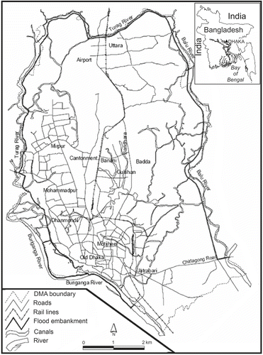
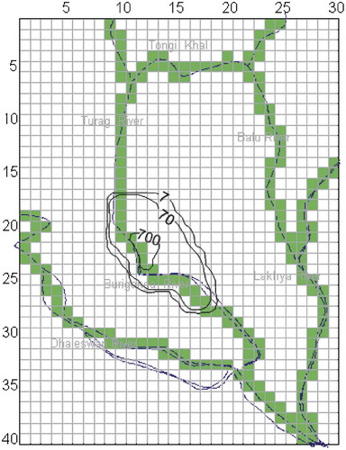
Dhaka () has a long history as a regional capital due to its strategic position at the head of the Bay of Bengal. It is situated at a point on the River Buriganga where the slight elevation of the Madhupur Tract gives some protection against flooding. Four hundred years ago, in the pre-Mughal period, Dhaka was restricted to an area of 1.5 km2 at the junction of the Buriganga and Dholai Khal Rivers. At the beginning of the seventeenth century, it became the capital of the Mughal viceroys and a centre for their expansion of trade. After the decline of Mughal power in the eighteenth century came the period of the British Raj (1764–1947). In 1874 the Chadnighat Water Works were constructed on the River Buriganga to provide water for Dhaka, which became the capital of the East Bengal and Assam Province in 1905. At the time of partition of India, when Dhaka became the capital of East Pakistan, the city had expanded to cover an area of 40 km2. In 1949 the Department of Public Health Engineering (DPHE) drilled the first borehole in Dhaka, initiating groundwater development for public supply (PS). By the 1960s, groundwater was the principal source for PS. In 1963 the Dhaka Water Supply and Sewerage Authority (DWASA) was established (Haq Citation2006) and by 1966 groundwater abstraction had reached 30 Mm3 per year, with surface water providing less than 10 Mm3 per year.
Figure 1. Dhaka: location map.
The independence of Bangladesh in 1971 stimulated the development of groundwater (Ahmed et al. Citation1999). At that time, the city had a population of less than two million and groundwater abstraction was less than 50 Mm3 per year. By 1992, 150 PS boreholes, up to 180 m deep, managed by DWASA and distributed across the city, were yielding a total of 170 Mm3 per year. By 1998 this had risen to 190 PS boreholes and 200 private boreholes abstracting in total 310 Mm3 (Ahmed et al. Citation1999), and by late 2000 DWASA was pumping approximately 400 Mm3 from a total of more than 330 boreholes (Morris et al. Citation2003). Current abstraction is closer to 455 Mm3 per year from 420 PS boreholes across a service area of 350 km2 (Haq Citation2006).
1.2. Urbanization and sources of contamination
Expansion and urbanization of Dhaka have been accompanied by industrial development, which is concentrated in the south-western and northern areas of the city. Natural drainage channels have been filled and concrete and bituminous surfaces have been extended. These developments in isolation would tend to reduce groundwater recharge, but leakage from urban water distribution and sewerage systems is likely to augment recharge overall (Lerner Citation1997), and urban leakage in Dhaka is thought to be extensive (van Wonderen Citation2003). Drainage of surface water has been disrupted as the small natural channels (khals) and low-lying areas have been infilled, often with municipal waste (Haq Citation2006). Construction of an earth embankment for flood protection in 1990 has resulted in the blocking of khals that remain, leading to frequent water-logging of the surface by contaminated water.
There is a variety of wastes that may contribute to the contamination of surface water and groundwater across the city. These include wastes from the tanning and dyeing (Zahid et al. Citation2006; Shams et al. Citation2009), metal-working and engineering industries; from solid industrial and domestic waste disposal; and from fuel spillages along the length of the river, particularly in the port area where rapid expansion has taken place. Untreated liquid industrial effluents and many foul sewers drain via canals directly to the River Buriganga. By the early 1990s, the main drain to the River Buriganga for industrial effluents, sewerage and urban run-off had an EC of 10,000 μS/cm (DoE 1993), an indication of its heavy pollutant load.
There has been an inevitable rise in waste production as the city and its population have expanded. By the turn of the century, Dhaka City Corporation was consigning more than 3000 tonnes of solid waste per day (including 500 tonnes domestic waste) to unlined landfills located in low-lying regions in the north-west and south-east of the city. On completion, the landfills are given a thin covering of soil and become areas designated for construction. There is no provision for leachate and landfill gas management or for monitoring, but the few data available, from close to the Jatrabari landfill (Ahmed et al. Citation1998), show that shallow groundwater is polluted by leachate.
2. Geology and hydrogeology of Dhaka
Dhaka lies at the southern end of the Plio–Pleistocene Madhupur Tract, the surface of which is elevated 1.5–10 m (average 6 m) above the surrounding floodplains. At the margins of the Madhupur Tract are the Recent flood plain deposits of the Rivers Turag, Buriganga, Balu and Tongi Khal. A summary of the Pliocene to Recent stratigraphy and hydrogeology of the Dhaka region is given in . The Madhupur Tract itself is a remnant block of Plio–Pleistocene sediments comprising the Dupi Tila and Madhupur Formations (Ahmed et al. Citation1999), isolated following widespread incision of the land surface during the late Quaternary, and its boundaries are in part fault-controlled (Monsur Citation1990; Hasan Citation1999). The implication is that the hydrogeological equivalent of the Dupi Tila sediments might be present at depth beyond the rivers bounding the Dhaka city region; however, there remains uncertainty over the nature of the boundaries to the Madhupur Tract.
Table 1. Hydrostratigraphy of the Dhaka region
The term Madhupur Clay is poorly defined but is widely used for the sequence of reddish-brown to grey silty clays of uncertain origin that crops out at the surface across much of the elevated Madhupur Tract. This unit is up to 45 m in thickness (an average of 10 m thick in Dhaka) and has a fine sandy member at its base. Drainage channels and shallow depressions on the Madhupur Tract are partially infilled with grey and yellow organic-rich sands and clays of the Holocene Bashabo Formation. Monsur (Citation1990) considered the Madhupur Clay a sedimentary formation with interbedded palaeosol horizons, whereas Alam et al. (Citation1990) considered it a ‘residuum’. Whatever its origin, the Madhupur Clay surface is more than 730,000 years old, with the Bashabo Formation being less than 13,000 years old (Monsur Citation1990).
2.1. Aquifer system
The Madhupur Clay overlies a sequence of fine to coarse-grained, micaceous, quartzo-feldspathic sands, which constitute the Dupi Tila Formation. These sands, termed here the Dupi Tila aquifer system, are approximately 140 m thick in Dhaka. Fine-grained, silty sands at the top of the Dupi Tila Formation grade downwards into fine/medium-grained sands, and medium/coarse-grained sands with gravels towards the base, and a basal clay. A discontinuous clay layer divides the Dupi Tila system into two aquifers: an upper fine-grained aquifer (the upper Dupi Tila aquifer), 30–50 m thick, and a lower coarse-grained aquifer (the lower Dupi Tila aquifer), 80–100 m thick. The basal clay is 10–15 m thick and overlies a deeper sequence of sands that is greater than 100 m thick, lithologically resembling the Dupi Tila Formation. This has been termed the ‘deeper Dupi Tila aquifer’. This study concentrates on the upper and lower Dupi Tila aquifers, which have provided the majority of the groundwater resources of Dhaka to date. Recently, the basal clay layer has been penetrated by boreholes drilled for exploration of the deeper Dupi Tila aquifer beyond 200 m depth (Haq Citation2006), where conditions may be indicative of pre-development conditions in the upper and lower aquifers.
Throughout the Dupi Tila Formation, iron oxyhydroxides and secondary kaolinitic clays are common weathering products of the original mafic-rich sediments. In Sylhet and Assam, as throughout the Madhupur Tract, the Dupi Tila Formation is interpreted as a series of fining-upwards, meander and braided river deposits (Davies Citation1995). The Dupi Tila forms the principal aquifer beneath the Madhupur Tract (Ravenscroft Citation2003), acting as a multilayered, leaky aquifer system effectively confined by the Madhupur Clay. The Dupi Tila aquifer described here for Dhaka is equivalent to the Madhupur aquifer of Davies (Citation1995) and Miah and Rushton (Citation1997). The aquifer has no outcrop on the Madhupur Tract itself, but comparison of river bed elevations with the top of the Dupi Tila sands demonstrates that direct contact between the River Buriganga and the aquifer is possible along certain reaches (Hasan et al. Citation1998b). It is possible that contact between the rivers surrounding Dhaka and the Dupi Tila aquifer is more extensive than supposed: the Madhupur Clay is absent in site investigation boreholes drilled at a bridge construction site in the south-west of the city (Ahmed and Burgess Citation2003). The Bashabo Sands within the river floodplains might directly overlie the aquifer, but the extent of the overlap is unknown in detail. There is clearly significant potential for induced recharge to the aquifer from the river, especially in the south-west of Dhaka; it is here that the river pollution is most extreme (Rahman and Hossain Citation2008) and contact between the river and the aquifer is potentially greatest.
The short-term response of the Dupi Tila aquifer during pumping tests indicates confined or leaky behaviour; aquifer transmissivity is typically 500–2000 m2/day and the permeability is 15–30 m/day (Ravenscroft Citation2003). This is in comparison to the more transmissive (3000–5000 m2/day), unindurated and less weathered Late Pleistocene alluvial sands of the Dhamrai Formation (Davies Citation1995), which underlies the floodplains west of the Madhupur Tract. The lower permeability of the Dupi Tila sands has been attributed to the blocking of pore throats by weathering products (Davies Citation1995). Specific storage of the Dupi Tila aquifer is in the order of 10–5 m–1 and the specific yield ranges from 0.005 for clays to 0.08 for fine sands and 0.2 for medium sands, in comparison with a range of 0.03 for silt to 0.16 for fine sands of the Dhamrai Formation (Ravenscroft Citation2003).
2.2. Groundwater flow before urban development
Throughout the Madhupur Tract north of the Dhaka region, the level of saturation in the Madhupur Clay is close to the ground surface under natural conditions, with a shallow water table occurring typically at a depth of 2–5 m. The Madhupur Clay and/or the Bashabo Formation confines the Dupi Tila aquifer but the piezometric surface of the aquifer is below the Madhupur Clay water table, indicating a vertical hydraulic gradient downwards across the aquitard (Hasan Citation1999). This suggests that recharge to the Dupi Tila aquifer is by topographically-driven vertical leakage through the Madhupur Clay, as observed at an equivalent occurrence of the Dupi Tila aquifer, on the Barind Tract in north-west Bangladesh (Ahmed Citation1994; Hasan et al. Citation1998a). In the Barind region, groundwater is used for dry-season irrigation and the aquifer is in a less advanced state of development than in Dhaka. At the boundaries of the Madhupur Tract, in the floodplain areas, shallow alluvial sands of the Dhamrai Formation overlie the Dupi Tila sands. In some places the Dupi Tila sands may be exposed along sections of the river beds surrounding Dhaka (Hasan et al. Citation1998b). It is these regions of lower elevation that, by analogy with groundwater conditions across the present-day Barind Tract, are presumed to have been groundwater discharge zones under natural conditions and at earlier stages of aquifer development in the Dhaka region.
2.3. Current groundwater flow regime
The natural pattern of groundwater flow at the southern end of the Madhupur Tract has been much disturbed by intensive groundwater development for the water supply of Dhaka since the early 1970s. Large-scale groundwater abstraction has resulted in an extensive cone of depression centred on the city, over large parts of which the aquifer has become unconfined. Drawdown has increased at approximately 0.75 m per year since the late 1970s at the Motijheel observation piezometer, and over the past 30 years the cone of depression in the aquifer has developed to the stage that it now extends to the major river courses that delineate the southern portion of the Madhupur Tract (Ahmed et al. Citation1999). Steep potentiometric gradients close to the River Buriganga suggest that further spread of the cone of depression is restricted by induced river recharge. Further evidence of hydraulic continuity between the River Buriganga and the aquifer in southern Dhaka comes from correspondence between seasonal variation in river water EC and changes in groundwater EC at tubewells adjacent to the river, not seen further north in the city (Sharif Citation1995). To the east of the city, expansion of the cone of depression is limited by recharge induced from the deeply flooded lowlands between Dhaka and the River Balu. Here, where the Bashabo Sands are present and directly overlie the aquifer rather than the Madhupur Clay, the region of induced river recharge may be more extensive, yet the nature of the interaction is not known in detail.
Recharge sources will have been modified as vertical hydraulic head gradients changed in response to pumping, with potentiometric drawdown in the aquifer providing a greater potential for vertical recharge through the Madhupur Clay throughout the urban area where pumping is concentrated. In addition, recharge across the city area will be influenced by the effects of urbanization, which are difficult to quantify. Urban recharge is significantly reduced only where storm drainage systems are very effective (Lerner Citation2002), and water supply systems commonly leak at rates between 10% and 70%, hence providing a significant additional recharge source in urban areas (Lerner Citation1997). In Dhaka, leakage from water supply and drainage distribution systems has been estimated at between 25% and 45% (van Wonderen Citation2003) and is thereby thought now to provide a major source of recharge in the urban area. Despite the increasing potentiometric drawdown in the aquifer, it is apparent that the impact of groundwater pumping in Dhaka city is restricted in a regional sense by the combined effects of induced recharge from peripheral rivers and enhanced vertical leakage through the Madhupur Clay. The more recent expansion of the cone of depression northwards is the effect of new abstraction boreholes drilled as Dhaka city has grown in that direction.
Despite the widespread decline of the potentiometric level of the aquifer to 20 m or more below PWD (public works datum, approximately mean sea level), topographic surveys have indicated no subsidence of the land surface and future settlement is not thought to be significant (Haq Citation2006). The detrimental effects of intensive groundwater abstraction on borehole productivity, infrastructure and maintenance in Dhaka (Morris et al. Citation2003) are additional to the implications for groundwater quality that is the concern addressed by this article. The River Buriganga, a major source of induced river recharge, is known to be polluted in parts (DoE Citation1993; Ahmed et al. Citation1999; Rahman and Hossain Citation2008). Also, there are many potential sources of contamination of recharge as vertical leakage in the urban area (Haq Citation2006). A crucial question that arises is the extent to which the polluted nature of the recharge sources threatens the quality of groundwater, and hence the sustainability of aquifer development, in the long term.
3. Groundwater quality
3.1. Natural groundwater chemistry
Groundwater from the Dupi Tila aquifer in the Madhupur Tract region beyond Dhaka is of calcium-bicarbonate to sodium-bicarbonate type, with total dissolved solids normally less than 350 mg/l, and is oxygenated, with a slightly acidic pH (Davies Citation1995). These features result from successive periods of oxidation and weathering of the original Dupi Tila sediments under stages of low sea level during the Late Quaternary, which have transformed the less stable minerals, flushed the aquifer of the more mobile constituents and rendered the aquifer oxidizing (Davies Citation1995). These baseline characteristics of groundwater in the Dupi Tila aquifer have been modified in Dhaka by the pervasive influence of recharge modification that has resulted in a general increase in the concentration of chloride, nitrate and sulphate, the principal inorganic indicators of urban contamination (Nazari et al. Citation1993). Contamination of groundwater by arsenic is a severe and widespread problem across the Holocene floodplain regions of central and southern Bangladesh (BGS and DPHE 2001), associated with reductive dissolution and desorption of arsenic from oxyhydroxide particles and grain coatings (Nickson et al. Citation2000). However, conditions in the Plio–Pleistocene Dupi Tila sands of the Dhaka region are pervasively oxidizing, and arsenic concentration in groundwater from the Dupi Tila aquifer of Dhaka is less than 3 μg/l (BGS and DPHE Citation2001), well below the 10 μg/l provisional WHO guideline value for arsenic in drinking water.
3.2. Groundwater quality changes in response to pumping
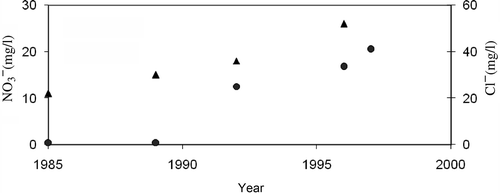
The Bangladesh Water Development Board has monitored groundwater quality in central Dhaka at two boreholes, at Motijheel and at Muhammedpur (), since 1974. The reliability of the Bangladesh Water Development Board data is in question as poor ionic balances are indicated (Hasan Citation1999). Surveys of the spatial variation in the quality of Dupi Tila groundwater across the city have previously been reported by Welsh (Citation1966), Alam (Citation1985) and Ahmed et al. (Citation1995). The data indicate deterioration in the quality of groundwater in the aquifer over this period. The increasing trends of chloride and nitrate, both general indicators of urban contamination in this aerobic aquifer, between 1985 and 1996 are illustrated in .
Figure 2. Chloride (solid triangles) and nitrate (solid circles) in groundwater west of Old Dhaka and south of Mohammadpur, 1985–1996. FootnoteNotes.
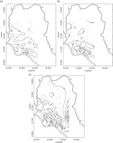
Sequential surveys of the spatial variation in groundwater EC at the depth of PS borehole abstraction, undertaken in 1996 (Hasan Citation1999), 1999 (Rihani Citation1999) and 2005, incorporating more than 90 pumping boreholes across the city, are illustrated in . Both the maximum groundwater EC and the spatial extent of elevated groundwater EC increased between 1996 and 1999. By 1999, a plume of lower quality water, indicated by EC > 500 μS/cm, extended across the aquifer in a band approximately 5 km long and 2 km wide. The spatial extent of the 500 μS/cm contour had further increased by 2005. The majority of PS boreholes adjacent to the River Buriganga record groundwater with sequentially higher EC in 1996, 1999 and 2005. The maximum value of groundwater EC recorded in 1999 was 1240 μS/cm compared with 750 μS/cm in 1996. The position of the 300 μS/cm contour has moved progressively northwards, reflecting a pervasive invasion of lower quality water into the aquifer as the urban area has expanded in that direction.
Figure 3. Regional variation in groundwater electrical conductivity (EC) in the Dupi Tila aquifer, Dhaka in μS/cm. (a) 1996, (b) 1999, (c) 2005. North lies to the top of the diagrams. FootnoteNotes.
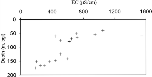
Vertical profiles of groundwater quality, illustrated for 1996 in , demonstrate much greater contamination at shallow levels in the aquifer than at the levels of the DWASA production wells. Further demonstration of the potential importance of recharge as vertical leakage comes from preliminary observations of organic contaminants in the Dupi Tila groundwater: chloroform, perchloroethylene, p-xylene and benzene have been identified in the aquifer beneath the industrial area south of Muhammadpur (Hasan Citation1999).
Figure 4. Vertical profiles of groundwater electrical conductivity (EC) in the Dupi Tila aquifer, Dhaka. FootnoteNotes.
The observed groundwater quality distribution and the pattern of potentiometric drawdown in combination suggest the possibility of induced recharge of the lower Dupi Tila aquifer from the River Buriganga. The extent of the intruded plume of low-quality groundwater is coincident with the reach of the river that is most polluted by industrial effluents (DoE Citation1993). However, the zone of greatest groundwater contamination is also situated directly under the industrial area in the south-west of the city to the west of Old Dhaka. Vertical leakage through the Madhupur Clay of low-quality urban recharge in this region may be an important factor determining the pattern of groundwater quality in the aquifer. The relative significance of contamination associated with these two modes of recharge and the likely rate and scale of groundwater quality deterioration in the future are important issues for the effective groundwater quality management of the Dupi Tila aquifer. Both issues are addressed below by groundwater modelling.
4. Evaluating contaminant sources by solute transport modelling
A groundwater flow model of the Dhaka region (Hasan Citation1999) extended a previous model developed for DWASA (van Wonderen Citation2003) which had the primary purpose of assessing the impact of additional abstraction boreholes on water levels in the aquifer. The updated flow model incorporates data to 1998, using MODFLOW (McDonald and Harbaugh Citation1988) to support models of solute transport using MT3D (Zheng Citation1992). The flow model includes the Dhaka metropolitan area and its immediate surroundings within their regional context over an area of approximately 1200 km2, using a 40 by 30 grid of cells of dimension 1 km2 (). The aquifer system is represented by four layers (): the upper aquitard (the Madhupur Clay with lateral transition into the Bashabo Sands) and the upper and lower aquifers of the Dupi Tila Formation separated by the intervening, discontinuous, clay aquitard.
Figure 6. Simulated pattern of groundwater quality in the lower Dupi Tila aquifer, 1999: contamination (concentration 1000 mg/l) introduced as induced recharge from a contaminated reach of the River Buriganga west of Old Dhaka.
4.1. Modelling groundwater flow
In the groundwater flow model, recharge is simulated both as induced river recharge and as a specified water flux to the top layer of the model representing the Madhupur Clay/Bashabo Sands. A series of head-dependent river boundary cells represent the rivers, varying in width from 60 to 300 m, and partially penetrating the upper aquitard or the upper aquifer, according to the geometry of each (Hasan et al. Citation1998b; Rihani Citation1999). Across the Dhaka region, recharge is provided as a specified flux rising from 0.065 mm/day to 0.5 mm/day over the period 1964–1998 to account for the increasing quantities of leakage from water supply and drainage distribution systems over that time, following the approach of van Wonderen (Citation2003). Calibration was made with attention to vertical permeability of the aquitard layers and riverbed sediments, firstly to extrapolated pre-development (1964) steady-state conditions, and secondly to historical records of groundwater levels in the upper aquifer between 1964 and 1998, which were compared with simulated heads in layer two of the model, representing the upper Dupi Tila aquifer. Transient calibration employed annual time steps. In addition to the uncertainties inherent in modelling recharge in the urban environment (Lerner Citation2002), the validity of the groundwater flow simulations relies on the realistic representation of rivers within the model, and many difficulties remain in modelling river boundaries (Winter et al. Citation1998). For the Dhaka aquifer the methodological difficulties are compounded (Hasan et al. Citation1998b) by
| a. | a paucity of potentiometric data beyond the river boundaries; | ||||
| b. | a lack of data on the extent and permeability of the river bed sediments; and | ||||
| c. | incomplete knowledge of the extent of the Bashabo Sands/Dupi Tila sands contact in the eastern part of Dhaka. | ||||
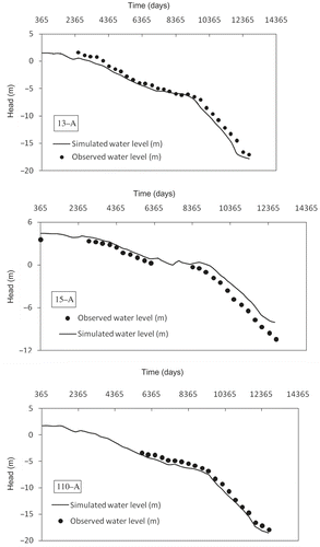
illustrates the quality of the model calibration. The groundwater flow model successfully simulates the continuous decline of water levels in the Dupi Tila aquifer in Dhaka, the result of abstraction considerably exceeding recharge. The rate of potentiometric decline is sensitive to the vertical permeability of the Madhupur Clay aquitard, and to a lesser extent to the hydraulic resistance of riverbed sediments of the River Buriganga, which are poorly specified by field measurements. A summary of the hydraulic properties in the calibrated model is given in , and aquifer water balances for 1966 and 1997 are summarized in . Under the abstraction regime of 1997, 30% of the recharge to the aquifer originated as induced recharge from the boundary rivers, with 50% of this being derived from polluted stretches of the River Buriganga. This represents a relative as well as an
Table 2. Summary of the hydraulic property values in the calibrated groundwater flow model
Table 3. Aquifer water balance for 1966 and 1997, from the calibrated groundwater flow model
Figure 5. Comparison of observed and modelled potentiometric head decline at representative locations across Dhaka, 1964–1998. 13-A, Motijheel; 15-A, Mirpur; 110-A, Dhanmondi (see ).
4.2. Modelling contaminant transport from the River Buriganga
Using the output of the calibrated MODFLOW groundwater flow model, the impact of induced recharge of contaminated water from the River Buriganga on groundwater quality in the aquifer was examined using the code MT3D (Zheng Citation1992), applying the method-of-characteristics solution scheme. Effective porosity values were taken as 0.10 (Madhupur Clay) and 0.15 (aquifer sands). Dispersivity was assigned following Xu and Eckstein (Citation1995): longitudinal dispersivity ranging from 11 to 25 m, and transverse and vertical dispersivity one order of magnitude smaller. The contamination source term was specified as a constant concentration of 1000 mg/l at the river boundary cells along a polluted 5 km stretch of the river west of Old Dhaka. The extent of contamination in the lower aquifer as modelled for 1999 () is similar to the pattern of elevated groundwater EC observed at the PS boreholes (). In addition, the maximum observed groundwater concentration in 1999, 735 mg/l at the DMC Hospital borehole in Old Dhaka, is in close agreement with the maximum modelled concentration for 1999, 850 mg/l in the same area. Information on historical levels of contamination in the river is not available, therefore the simulations are indicative only, yet the results show a similarity of form with the observed EC distributions.
4.3. Modelling contaminant transport from the southern industrial area of Dhaka
The impact of vertical leakage through the Madhupur Clay in areas of contaminated land related to industry and landfilling was examined by specifying a constant concentration of 1000 mg/l for recharge in these areas over the period 1964–1999, with reference to the EC of shallow groundwater in the upper aquifer measured in 1996. Using this source term, the modelled contaminant concentration in groundwater in the lower aquifer in 1999 is less than 10 mg/l, two orders of magnitude less than is observed in southern Dhaka. The model suggests that contamination entering the aquifer system from shallow urban and industrial sources is considerably diluted before it reaches the lower aquifer. Furthermore, the model as run forward to 2038 indicates that dissolved-phase urban contamination will not significantly affect groundwater quality in the lower aquifer over this time period, if conditions continue as at 1999; dilution by groundwater from beyond the urban area and from induced river recharge (when simulated to be free of contamination) maintains concentrations at a much lower level than in the shallow aquifer. This suggests that the observed vertical profiles of groundwater quality () are caused by progressive dilution with depth, essentially under steady-state conditions, rather than being a discrete transient state of contaminant invasion of the aquifer.
4.4. Implications for the significance of groundwater contamination sources
Simulations of contamination entering the aquifer as induced recharge from the River Buriganga are similar to observed patterns of groundwater quality distribution in the lower aquifer. In contrast, contaminated vertical leakage through the Madhupur Clay has a very much lesser effect at the level of the lower aquifer. The modelling therefore suggests that the River Buriganga is the principal source of dissolved-phase contamination threatening the PS boreholes in Dhaka. Fears that further deterioration of groundwater quality may be inevitable as contaminated water in the confining layers and upper part of the aquifer system moves down to the main aquifer (Ahmed et al. Citation1999) appear to be alleviated by the extent of dilution from regions beyond the urban area.
Particle tracking using the calibrated groundwater flow model and MODPATH (Pollock Citation1994) suggests transport times to PS boreholes in southern Dhaka of 15–20 years from the River Buriganga and 30–40 years from the industrial area west of Old Dhaka (Hasan Citation1999). Groundwater residence times have been estimated by others (M. Stute, personal communication) for two deep tubewells in southern Dhaka, using the 3H–3He method, at 17.7 ± 2 and 18.3 ± 0.8 years, respectively, in good agreement with the modelling indications that the River Buriganga is the primary source of dissolved contaminants in the aquifer.
5. Evaluating contaminant sources using environmental isotopes
Oxygen and hydrogen isotopes of groundwater and carbon isotopes of dissolved inorganic carbon (DIC) in groundwater throughout the Dhaka urban area have been analysed in an evaluation of contaminant sources independent of groundwater flow modelling. O and H isotopes are fully conservative in the aquifer and may discriminate effectively between waters from different sources. Carbon isotopes provide an additional indication of possible mixing series.
5.1. Sampling and isotopic ranges
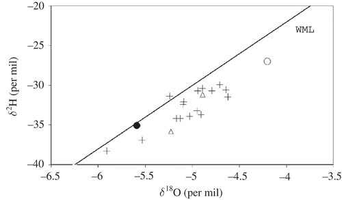
Groundwater samples for isotope analysis were collected from 17 boreholes (116–179 m depth) in the lower Dupi Tila aquifer and from two shallow hand-pumped tubewells (40–55 m depth) in the upper Dupi Tila aquifer. The isotopic range of the groundwaters is rather limited: −5.91 to −4.62 per mil δ18O, −38.3 to −29.9 per mil δ2H, as illustrated in . Full results are available in Darling et al. (Citation2002). The isotopic composition of recent meteoric recharge in the region is taken as the median value of 59 shallow groundwater samples from tubewells in the Faridpur thana (county) some 70 km west-south-west of Dhaka (BGS and DPHE Citation2001). The isotopic range of the River Buriganga at Dhaka is wide by comparison with Dhaka groundwater, −1.4 to −10.1 per mil δ18O and −5.8 to −69.1 per mil δ2H (unpublished data). Monsoonal discharge of the River Ganges originating in the Himalayan catchments upstream of Uttar Pradesh in India is known to be isotopically depleted, at approximately −10 per mil δ18O, and seasonal enrichment by almost 3 per mil has been observed in the upper Gangetic plains (Navada and Rao Citation1991).
Figure 7. Delta plot of oxygen and hydrogen stable isotope data for groundwater from the lower Dupi Tila aquifer at Dhaka. Two samples from the upper Dupi Tila aquifer are also shown (open triangles). The Chadnighat Water Works tubewell sample, representing Buriganga River water (see text), is illustrated as a solid circle. Recent meteoric recharge (see text) is indicated as an open circle. WML, the world meteoric line (Craig Citation1961).
5.2. Isotope spatial and depth distributions
The spatial distributions of δ18O and δ2H within Dhaka are shown in . Groundwater with δ18O more negative than −5 per mil is more common in the south of the city adjacent to the River Buriganga, in the region characterized by elevated groundwater EC. The lack of depth profile () reflects the vertical mixing induced throughout the aquifer system by the intense pumping from PS boreholes in the lower aquifer. There is however an approximately linear relationship with proximity to the nearest river (), and this is reflected in the correlation between isotopic character and EC ().
Figure 8. The spatial distribution of (a) δ18O and (b) δ2H in Dhaka groundwater. Open circles denote PS boreholes in the lower Dupi Tila aquifer; closed circles denote shallow hand-pumped tubewells in the upper Dupi Tila aquifer; cross denotes the River Buriganga.
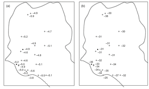
Figure 9. Groundwater δ2H versus (a) depth in metres below ground surface, (b) groundwater electrical conductivity (EC) in μS/cm, and (c) proximity to the nearest river; (d) dissolved inorganic carbon (DIC) δ13C versus proximity to the nearest river. Open circles denote PS boreholes in the lower Dupi Tila aquifer; closed circles denote shallow hand-pumped tubewells in the upper Dupi Tila aquifer; cross denotes the River Buriganga.
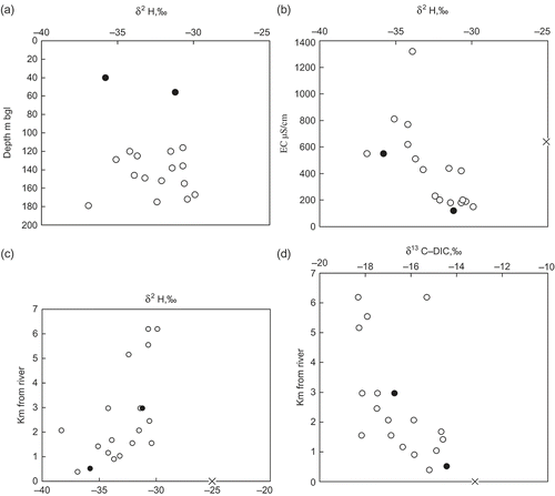
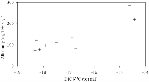
Groundwater DIC δ13C values also show an approximately linear relationship with distance from the nearest river (). The spatial distribution of δ13C in DIC ranges from values more depleted than −18 per mil in central parts of the city to values more enriched than −15 per mil close to the River Buriganga. The extent of variation of δ13C in river water is unknown, but the more enriched groundwater DIC compositions would be the expected result of partial equilibration with atmospheric CO2 in the river. By contrast, the more depleted δ13C values, related to a groundwater alkalinity content of less than 100 mg/l (), are typical of relatively young groundwater unreacted with aquifer carbonate.
Figure 10. Dissolved inorganic carbon (DIC) δ13C versus alkalinity as HCO3– in Dupi Tila groundwater.
5.3. Implications for sources of induced recharge
The linearity of the δ18O versus δ2H distribution suggests a mixing series, with the relatively heavier component representing recently infiltrated meteoric recharge. The origin of the more depleted component of the mixing series cannot be established unambiguously as river water on isotopic grounds, as isotopically depleted groundwater has been identified beneath the floodplains of western Bangladesh at depths greater than 140 m (Burgess et al. Citation2007) and cannot be discounted at Dhaka. However, groundwater EC measurements are consistent with a river water origin for the more depleted endmember. Therefore, in combination, the EC measurements and the isotope analyses do effectively discriminate between induced river recharge and vertical leakage through the Madhupur Clay, the two likely modes of groundwater contamination suggested by observation of the groundwater quality distributions. This evaluation demonstrates that groundwater pumped from the lower Dupi Tila aquifer in the south-west of Dhaka is recharged from the River Buriganga, and the observed groundwater quality deterioration is a result of invasion of the aquifer by low-quality river water in south-west Dhaka. These conclusions are consistent with the conclusions independently derived from groundwater modelling.
The groundwater sample most closely representing the river water endmember is taken to be that from the Chadnighat Water Works tubewell (this is not treated surface water, but groundwater from a tubewell in the treatment works compound), having amongst the most depleted δ18O and δ2H values, the most enriched DIC δ13C values, and being in close proximity to the river. Taking the Water Works borehole sample as representative of mass-averaged River Buriganga water, the plot of δ13C versus alkalinity as HCO3– in also reveals an apparent mixing series between river water and recently recharged groundwater. The carbon isotopes show no indication of the organic matter oxidation that is characteristic of alluvial aquifers beneath the major floodplains of Bangladesh (Davies Citation1995).
An interpretation of the linear δ18O versus δ2H relationship as a simple two-member mixing series between river water and recent meteoric recharge suggests that all groundwater in the lower Dupi Tila aquifer of Dhaka contains at least 30% river water. This is an overestimate of the river water component, as in reality groundwater in the Dupi Tila aquifer is a complex multi-component mixture. Groundwater modelling emphasizes the multiple sources of recharge to the Dupi Tila aquifer, comprising induced river recharge, vertical leakage through the Madhupur Clay across the urban area (predominantly as leakage from water distribution and sewerage systems), meteoric recharge through the Madhupur Clay beyond the urban area and a small proportion released from aquifer storage (i.e. native water from the aquifer). Carbon isotopes provide the more realistic indication that induced river recharge has minimal impact in central Dhaka.
6. Discussion
As Dhaka continues to expand, the Dupi Tila aquifer beneath the city will eventually be unable to meet the rising demand for water (Haq Citation2006). Protection of the aquifer for use as a strategic supply of high-quality water is an important option for water managers, an alternative to continuing water level decline (Morris et al. Citation2003) and unabated deterioration of groundwater quality. Groundwater flow modelling suggests that a new hydraulic equilibrium would be established within 4–7 years of an enforcement to prevent further abstraction from the aquifer (Hasan Citation1999; Rihani Citation1999; van Wonderen Citation2003). Careful monitoring will be necessary to validate the model predictions. The borehole network for monitoring groundwater levels should be expanded to cover the entire area between the Rivers Buriganga, Balu, Turag and Tongi Khal. Shallow water level decline in multiple aquifer systems can be used to indicate over-abstraction at an early stage (Hasan et al. Citation1998a; Rushton Citation1998). Therefore, the water level-monitoring boreholes should be completed to monitor water levels in both the upper and the lower aquifers.
Surveys of groundwater quality across Dhaka demonstrate the impact of intensive groundwater abstraction, which has led to invasion of the Dupi Tila aquifer by lower quality water in parts of the city. Groundwater modelling and groundwater chemical/isotopic monitoring are both capable of discriminating between the effects of induced recharge from the polluted River Buriganga and of enhanced vertical leakage through the Madhupur Clay in contaminated urban areas. These two approaches independently confirm that induced recharge from the River Buriganga is the dominant source of lower quality water in the lower Dupi Tila aquifer. The River Buriganga should therefore be the primary target for any aquifer protection strategy.
The solute transport model has been applied to simulate the effect on groundwater quality in the aquifer of cleaning up the River Buriganga (Rihani Citation1999). Indicative contaminant concentration in the polluted reach of the river was reduced from an initial 1000 to 0 mg/l at year 2000 to coincide with a hypothetical prevention of increases in groundwater abstraction from that time. Within 20 years of action to clean up this reach of the river, by 2017, the modelled contaminant concentration in the lower Dupi Tila aquifer falls below 280 mg/l throughout the city, equivalent to about 400 μS/cm (the European Guide level for EC in drinking water). For the more realistic situation of a staged improvement in river water quality, to 700 mg/l at 2002, 400 mg/l at 2005, 100 mg/l at 2010 and 0 mg/l thereafter, the model indicates contaminant concentration in the lower aquifer falling to 280 mg/l by 2025. Furthermore, the model suggests that attention to the River Buriganga is more effective than installation of a series of barrier boreholes along the east bank of the river for interception of polluted river recharge. Abstraction adjacent to the river is already high and partially restricts invasion of the aquifer by polluted river water. The model shows that additional interception boreholes have little effect other than to further depress water levels in the aquifer.
Preliminary indications are that the deterioration in the quality of urban groundwater beyond the influence of the River Buriganga is restricted by the extent of dilution with groundwater from beyond the urban area. More regular and more detailed monitoring of groundwater quality is required to confirm this. Groundwater quality, which is currently only monitored at two locations at the depth of groundwater abstraction for PS, should be monitored at an expanded network of boreholes throughout the city, at shallow levels in the aquifer adjacent to the River Buriganga and beneath industrial areas and landfill sites, as well as at the depths of groundwater abstraction. PS wells should be included in an enhanced scheme for monitoring groundwater quality. Samples from these boreholes, which are pumped continuously and at a high rate, indicate the general water quality in the aquifer averaged over larger volumes than the samples from targeted monitoring boreholes.
Non-aqueous phase contaminants in groundwater beneath Dhaka remain a potentially important, unresolved, issue. They have been observed in a preliminary reconnaissance of groundwater beneath the two main industrial areas of the city and may be present in the aquifer in significant quantities. The industrial areas of Dhaka are likely sources for non-aqueous phase contaminants (Mahmud Citation2001; Haq Citation2006). Given that the entire Dhaka urban area is encompassed within the combined catchments of the PS boreholes, no restricted borehole protection zonation is practicable. A secondary objective in support of aquifer protection should be management and disposal of waste effluents, particularly organic effluents, at industrial sites.
These conclusions on the vulnerability of the upper and lower Dupi Tila aquifers at Dhaka to the effects of intensive abstraction also apply in general to the ‘deeper’ aquifer at depths of 250 m and more. Exploitation of the groundwater resources of the deeper aquifer should be preceded and accompanied by a programme of groundwater monitoring similar to that indicated for the Dupi Tila aquifer.
Acknowledgements
MKH gratefully acknowledges a scholarship from the Commonwealth Commission to study for a PhD at University College London. We thank DWASA for allowing us access to boreholes and to data sources compiled for groundwater flow modelling of the Dhaka region by Mott MacDonald Ltd. We thank Jan van Wonderen of Mott MacDonald Ltd. for helpful discussions of the groundwater flow model developed by him for DWASA, and Jane Dottridge, formerly of University College London, for advice during the early stages of the modelling. We are grateful to Peter Ravenscroft, formerly of Mott MacDonald International, for generous hospitality in Dhaka and for valuable discussions on the hydrogeology of Dhaka. Chemical analysis of groundwater samples was undertaken in the Wolfson Environmental Geochemistry Laboratory at UCL and the Natural Environment Research Council (NERC) ICP-AES laboratory at Royal Holloway, University of London. The assistance of Mr. A.T. Osborn, Ms. H. Jones and Ms. N. Paige is gratefully acknowledged. Isotopic analysis was carried out in the Isotope Laboratory of the British Geological Survey at Wallingford, Oxfordshire. We thank Dr. Martin Stute and the Lamont-Doherty Earth Observatory for communicating the results of their tritium–helium age data. WGD contributes with the permission of the Director, British Geological Survey (NERC).
Additional information
Notes on contributors
William Graham Burgess
William Graham Burgess: Department of Earth Sciences, University College London, Gower St., London WC1E 6BT, UK.
Muhammed Kamrul Hasan
Muhammed Kamrul Hasan: Department of Earth Sciences, University College London, Gower St., London WC1E 6BT, UK.
Emma Rihani
Emma Rihani: Department of Earth Sciences, University College London, Gower St., London WC1E 6BT, UK.
Kazi Matin Ahmed
Kazi Matin Ahmed: Department of Geology, University of Dhaka, Dhaka 1000, Bangladesh.
Mohammad Abdul Hoque
Mohammad Abdul Hoque: Department of Earth Sciences, University College London, Gower St., London WC1E 6BT, UK.
William George Darling
William George Darling: British Geological Survey, Crowmarsh Gifford, Wallingford, Oxon OX10 8BB, UK.
Notes
Source: Data compilation from Hasan (Citation1999).
Source: 1996 data from Hasan (Citation1999); 1999 data from Rihani (Citation1999).
Source: Data from Hasan (Citation1999).
References
- Ahmed, KM., 1994. The hydrogeology of the Dupi Tila Sand aquifer of the Barind Tract, NW Bangladesh [PhD thesis]. University of London University College London (unpublished); 1994.
- Ahmed, KM, and Burgess, WG., 2003. "Surface water and groundwater interaction in Bangladesh hydrogeology". In: Rahman, AA, and Ravenscroft, PR, eds. Groundwater resources and development in Bangladesh. Dhaka, Bangladesh: The University Press Ltd; 2003. pp. 275–295.
- Ahmed, KM, Hasan, MA, Sharif, SU, and Hossain, KS, 1998. Effect of urbanisation on groundwater regime, Dhaka City, Bangladesh, J Geol Soc India. 51 (1998), pp. 229–338.
- Ahmed, KM, Hasan, MK, Burgess, WG, Dottridge, J, Ravenscroft, P, and van Wonderen, J., 1999. "The Dupi Tila aquifer of Dhaka, Bangladesh: hydraulic and hydrochemical response to intensive exploitation". In: Chilton, PJ, ed. Groundwater in the urban environment: selected city profiles. Rotterda, The Netherlands: Balkema; 1999. pp. 19–30, International contributions to hydrogeology 21.
- Ahmed, KM, Woobaidullah, ASM, and Hasan, MA., 1995. Geochemistry of the Dupi Tila aquifers of Dhaka City, Bangladesh, Acta Univer Carolinae Geol Prague. 39 (1995), pp. 113–121.
- Alam, M., 1985. "Evaluation of groundwater conditions of Dhaka city [MSc thesis]". In: Dhaka University (unpublished). 1985.
- Alam, MK, Hasan, AKMS, Khan, MR, and Whitney, JW., 1990. Geological map of Bangladesh. Dhaka, Bangladesh: Geological Survey of Bangladesh; 1990.
- [BGS and DPHE] British Geological Survey and Department of Public Health Engineering, , 2001. "Arsenic contamination of groundwater in Bangladesh". In: Kinniburgh, DG, and Smedley, PL, eds. British Geological Survey Report WC/00/19. Keyworth, UK: British Geological Survey; 2001.
- Burgess, WG, Ahmed, KM, Carruthers, A, Cheetham, H, Cobbing, J, Cuthbert, M, Mather, S, and McCarthy, E., 2007. "Trends in arsenic concentration at tubewells in Bangladesh: conceptual models, numerical models, and monitoring proxies". In: Bhattacharya, P, Mukherjee, AB, Bundschuh, J, Zevenhoven, R, Loeppert, RH, Elsevier, B.V., and Jerome, O. Nriagu, eds. Arsenic in soil and groundwater environments: biogeochemical interactions, Elsevier Book Series: Trace metals and other contaminants in the environment. Vol. 9. 2007. pp. 63–84, Series Editor.
- Craig, H., 1961. Isotopic variations in meteoric water, Science 133 (1961), pp. 1702–1703.
- Darling, WG, Burgess, WG, and Hasan, MK., 2002. "Isotopic evidence for induced river recharge of the Dupi Tila aquifer in the Dhaka urban area, Bangladesh". In: The application of isotope techniques to the assessment of aquifer systems in major urban areas. Vienna, Austria: International Atomic Energy Agency; 2002. pp. 95–107, TecDoc-1298.
- Davies, J., 1995. "The hydrogeochemistry of alluvial aquifers in central Bangladesh". In: Nash, H, and Mc Call, GJH, eds. Groundwater quality. London (UK): Chapman and Hall; 1995. pp. 9–18.
- [DoE] Department of Environment, , 1993. Water quality data for Rivers Buriganga, Meghna, Balu, Sitalakhya, Jamuna (1981–1990). Dhaka, Bangladesh: Department of Environment, Government of Bangladesh; 1993. p. 313.
- Foster, SSD., 2001. The interdependence of groundwater and urbanisation in rapidly developing cities, Urban Water. 3 (2001), pp. 185–192.
- Foster, SSD, Morris, BL, Lawrence, AR, and Chilton, PJ., 1999. "Groundwater impacts and issues in developing cities – an introductory review". In: Chilton, PJ, ed. Groundwater in the urban environment: selected city profiles. Rotterdam, The Netherlands: Balkema; 1999. pp. 3–16, International contributions to hydrogeology 21.
- Hasan, MK., 1999. The vulnerability of the Dupi Tila aquifer, Dhaka, Bangladesh [PhD thesis]. London, UK: University of London; 1999, University College London (unpublished).
- Hasan, MK, Ahmed, KM, Burgess, WG, Dottridge, J, and Asaduzzaman, M., 1998a. Hydrology in a changing environment. Presented at Proceedings of the British Hydrological Society International Conference. Exeter, UK, Jul, 1998.
- Hasan, MK, Burgess, WG, and Dottridge, J., 1998b. Gambling with groundwater – physical, chemical and biological aspects of aquifer-stream relations. Presented at Proceedings of the Joint meeting of the XXVIII Congress of the International Association of Hydrogeologists and the annual meeting of the American Institute of Hydrologists. Las Vegas, NV, Sep, 1998.
- Haq, KA., 2006. Water management in Dhaka, Water Res Dev. 22 (2006), pp. 291–311.
- Lerner, DN., 1997. Groundwater in the urban environment. Presented at Proceedings of the XXVII Congress of the International Association of Hydrogeologists. Nottingham, UK, Sep, 1997, Problems, processes and management.
- Lerner, DN., 2002. Identifying and quantifying urban recharge: a review, Hydrogeol J. 10 (2002), pp. 143–152.
- Mahmud, A., 2001. Hell from leather: Are Bangladeshi tanneries to blame for health problems?. The Guardian; 2001.
- McDonald, MG, and Harbaugh, AW., 1988. "MODFLOW: a modular three-dimensional, finite difference groundwater flow model". In: Techniques of water resources investigations. Reston, VA: U.S. Geological Survey; 1988, Book 6, Chapter A1..
- Miah, MM, and Rushton, KR., 1997. Exploitation of alluvial aquifers having an overlying zone of low permeability: examples from Bangladesh, Hydrol Sci J. 42 (1997), pp. 67–79.
- Monsur, MH., 1990. Stratigraphical and palaeomagnetical studies of some quaternary deposits of the Bengal Basin, Bangladesh [DSc dissertation]. Belgium: Free University of Brussels; 1990, (unpublished).
- Morris, BL, Lawrence, AR, and Foster, SSD., 1997. Groundwater in the urban environment. Presented at Proceedings of the XXVII Congress of the International Association of Hydrogeologists. Nottingham, UK, Sep, 1997, Problems, processes and management.
- Morris, BL, Seddique, AA, and Ahmed, KM., 2003. Response of the Dupi Tila aquifer to intensive pumping in Dhaka, Bangladesh, Hydrogeol J. 11 (2003), pp. 496–503.
- Navada, SV, and Rao, SM., 1991. Study of Ganga river-groundwater interaction using environmental oxygen-18, Isotopenpraxis. 27 (1991), pp. 380–384.
- Nazari, MM, Burston, MW, Bishop, PK, and Lerner, DN., 1993. Urban groundwater pollution: a case study from Coventry, UK, Ground Water. 31 (1993), pp. 417–424.
- Nickson, R, McArthur, JM, Ravenscroft, PR, Burgess, WG, and Ahmed, KM., 2000. Mechanism of arsenic release to groundwater, Bangladesh and West Bengal, Appl Geochem. 15 (2000), pp. 403–413.
- Pollock, DW., 1994. User's Guide for MODPATH/ MODPATH-PLOT, Version 3: a particle tracking post-processing package for MODFLOW, the U.S. Geological Survey finite-difference ground-water flow model. Reston, VA: U.S. Geological Survey; 1994, Open-File Report 94–464.
- Rahman, S, and Hossain, F., 2008. Spatial assessment of water quality in peripheral rivers of Dhaka city for optimal relocation of water intake point, Water Res Manage. 22 (2008), pp. 377–391.
- Ravenscroft, PR., 2003. "Overview of the hydrogeology of Bangladesh". In: Rahman, AA, and Ravenscroft, PR, eds. Groundwater resources and development in Bangladesh. Dhaka, Bangladesh: The University Press Ltd; 2003. pp. 43–86.
- Rihani, E., 1999. Modelling the vulnerability of the Dupi Tila aquifer in Dhaka, Bangladesh [MSc thesis]. London, UK: University College London; 1999, (unpublished).
- Rushton, KR., 1998. Hydrology in a changing environment. Presented at Proceedings of the British Hydrological Society International Conference. Exeter, UK, Jul, 1998.
- Shams, KM, Tichy, G, and Sager, M., 2009. Soil contamination from tannery wasteswith emphasis on the fate and distribution of tri- and hexavalent chromium, Water Air Soil Pollut. 199 (2009), pp. 123–137.
- Sharif, SU., 1995. Urban and industrial pollution to groundwater of the southern part of Dhaka city [MSc thesis]. Dhaka, Bangladesh: Department of Geology Dhaka University; 1995, (unpublished).
- http://www.un.org/esa/population/publications/wup1999/wup99ch1.pdf Last accessed 27Jul2010. , United Nations. 2010. World urbanization prospects: the 1999 revision [Internet].
- van Wonderen, JJ., 2003. "The use of groundwater models for resource assessment in Bangladesh". In: Rahman, AA, and Ravenscroft, PR, eds. Groundwater resources and development in Bangladesh. Dhaka, Bangladesh: The University Press Ltd; 2003. pp. 115–139.
- Welsh, JL., 1966. Report on Dhaka groundwater supply. East Pakistan: Unpublished Report by Parsons Corporation; 1966.
- Winter, TC, Judson, WH, Franke, OL, and Alley, WM., 1998. "Groundwater and surface water a single resource". In: Circular 1139. Denver, CO: U.S. Geological Survey; 1998.
- Xu, M, and Eckstein, Y., 1995. Use of weighted least squares method in evaluation of the relationship between dispersivity and field scale, Ground Water. 33 (1995), pp. 905–908.
- Zahid, A, Balke, KD, and Hassan, MQ., 2006. Evaluation of aquifer environment under Hazaribagh leather processing zone, Dhaka city, Environ Geol. 50 (2006), pp. 495–504.
- Zheng, C, 1992. MT3D: a modular three-dimensional transport model, version 1.5. Documentation and Users Guide. Bethesda, MD: S.S Papadopoulos and Associates Inc; 1992.