
 ?Mathematical formulae have been encoded as MathML and are displayed in this HTML version using MathJax in order to improve their display. Uncheck the box to turn MathJax off. This feature requires Javascript. Click on a formula to zoom.
Abstract
Resilience represents a key issue for modern societies. Resilience is related to sustainability as safeguarding environmental assets can reduce risk and provide resources to facilitate recovery. The methodology quantifies the disaster resilience of city ecosystems by measuring urban efficiency in the event of shocks, according to an anthropocentric perspective. Cities are modelled as hybrid social–physical networks (HSPNs), accounting for interrelations between the physical and social components. Seismic scenarios are run on diverse urban shapes and on the real case study of the city of Sarno. Results on synthetic HSPNs show consistency with the real case study, therefore the validity of the model is highlighted. Urban shapes or forms prove to have a significant impact on urban efficiency in terms of service delivery, and on urban disaster resilience. The methodology proposed in this paper could be a useful tool for urban planners, particularly in cities with high exposure to natural disasters.
1. Introduction
The rate of occurrence and severity of natural disasters is recognised as one of the main global issues affecting human well-being and environmental safety.
Climate change is likely to exacerbate many existing risks and create new ones. Cities are highly vulnerable to natural disasters due to their exposure to physical risk (for example, due to the proportion of the urban population living in coastal regions) and the high concentration of people and infrastructures. The vulnerability of contemporary city complex systems is triggering an increasing need for new paths of prevention, preparedness and rapid recovery. Cities have substantial potential to address such issues, since they are the cornerstone of innovation and technological development. While the wealth and population density of cities in same ways impose higher economic and ecological costs, cities also have particularly large opportunities to enhance efficiency and optimise resource use as population density can improve the efficiency of infrastructure and service provision (Newman & Kenworth Citation1991; Floater et al. Citation2014; Gouldson et al. Citation2015). Focusing on local environments and systems is recognised as one of the most effective means to efficiently manage risks, allowing tailored approaches to meet the particular sustainability and resilience goals of the community (Peter Citation2016; Leung et al. Citation2016; Delgado Ramos Citation2016). Therefore, although urban risk is an important challenge for communities, urbanisation and urban development also provide new opportunities to pursue more resilient forms of development.
Resilience refers to the capacity of a complex system, composed of non-homogeneous components interacting and coexisting, to withstand an external stress and bounce backwards or forwards to an equilibrium state, which can be the same of the pre-event phase but also a new one (Asprone & Manfredi Citation2015; Bozza et al. Citation2015a; Dodman et al. Citation2016). The concept has been applied to different topics over decades. It has been used in physics to measure the ability of materials to withstand loads without permanent strain. It was also used in medicine (Lotka Citation1925; Pfeiffer Citation1929), in biology as the magnitude of disturbance that can be absorbed by an ecosystem (Holling Citation1973), and in psychology as the ability of human organisms to adapt to and cope with stress (Werner Citation1971; Garmezy Citation1973). An innovative, transdisciplinary field of study is developing around urban resilience. According to a holistic view, cities are complex systems made of physical and human components, which are mutually correlated and interacting. Hence, cities can be understood as systems being subjected to dynamic equilibrium states and continuously exposed to external changes like ecosystems (Folke Citation2006; Plummer & Armitage Citation2007; Gunderson Citation2010).
Disaster resilience specifically has been defined as the ability of a system to cope with stress (Adger Citation2000), as the ability to maintain the system identity (Cumming et al. Citation2005), as the amount of disturbance absorbed before change of state and the time needed to return to global equilibrium (Holling Citation1996; Gunderson et al. Citation2002) and as the ability to maintain a steady ecological state related to the functioning of the system (Pimm Citation1984). The use of the term resilience concept implies a wide and highly diversified range of components, factors and intrinsic dynamics to be accounted for in the event of a disaster. In literature, this definition is adapted to contemporary complex systems, such as ecosystems, economics, human bodies and to cities (Zhou et al. Citation2010). Urban disaster resilience – the capability of cities and communities to withstand strong unexpected events and the pace of their recovery in a functional and efficient fashion – is triggering increasing interest in many scientific contexts (Asprone & Manfredi Citation2015).
In this study, the connection between the concept of city disaster resilience and city sustainability is addressed according to Asprone and Manfredi (Citation2015). A ‘sustainable’ process ensures the well-being of both current and future generations. In urban environments, this principle can be applied to both local resources management (such as water and land), and in terms of resources obtained through global supply chains (e.g. energy). With this, a fundamental requirement for communities threatened by natural disasters is to optimise resource use and prevent resource depletion. Achieving sustainability, therefore, means that urban transformations need to be studied according to a life cycle approach, considering (as for typical engineering systems) the phases of construction, operation, maintenance and disposal. To simultaneously address disaster resilience, one must include the hazardous event occurrence (HEO) phase. In this phase, consequences arising from the occurrence of a hazardous event are evaluated in terms of economic, environmental and social burdens. When these effects are minimised, a city can be considered resilient, that is sustainability in the HEO phase is ensured. Keeping with this, resilience to natural disasters represents a core concept substantially contributing to sustainability.
When studying sustainability and resilience issues at the local level, this complexity is a fundamental aspect to be taken into account. Recent applications in the field of civil engineering approach these questions according to graph theory, by accounting for social and physical system city components and their mutual interrelations. With this method, a city can be modelled as a complex network, being composed of arches, representing links between urban structures and services, and nodes, representing the meeting points between them. The city social component can be considered by computing the citizens served by each urban structure and service to the network component representing it (nodes and arches) (Cavallaro et al. Citation2014; Bozza et al. Citation2015b). This model is called a hybrid social–physical network (HSPN). The disaster resilience of the city can then be tested by modelling the effect of a catastrophic event on the city’s built environment and consequently on the citizens using it, particularly in terms of the efficiency of use (Latora & Marchiori Citation2001). Hence, in this study, cities are understood as physical systems assessed through engineering metrics, but contextualised by imposing social criteria.
Major attempts in this field have been made by Cavallaro et al. (Citation2014) and Franchin and Cavalieri (Citation2013, Citation2015) to assess resilience to seismic catastrophes. Mensah and Dueñas-Osorio (Ouyang & Dueñas-Osorio Citation2014; Mensah & Dueñas-Osorio Citation2015) propose a framework for quantifying resilience of electric grids and distributed wind generation to hurricane hazards, with a particular focus on social issues, highlighting the high dependence of modern societies’ economies on high quality electricity. A recent attempt to integrate physical and socio-economic perspectives of resilience has been made with the PEOPLES Resilience Framework (Renschler et al. Citation2010), linking different resilience dimensions and resilience properties as proposed by Bruneau (Bruneau et al. Citation2003). Todini (Citation2000) considers urban water distribution systems and design as a series of interconnected closed and undirected loops, through which water flows are analysed. Leu et al. (Citation2010) propose an approach for quantifying resilience in transportation networks, also being modelled as graphs. Murray-Tuite (Citation2006) and Berche et al. (Citation2009) analysed the resilience of transportation networks under different attack scenarios. In this paper, a rigorous methodology is presented to model a city as an HSPN. HSPN enables us to assess efficiency engineering metrics and contextually quantify the physical and social urban resilience. Particularly, resilience is assessed following the approach from Bozza and Cavallaro (Cavallaro et al. Citation2014; Bozza et al. Citation2015b), based on the notion of efficiency according to Latora and Marchiori (Citation2001).
2. An experimental framework to assess urban resilience to disasters
The proposed framework focuses on the resilience of urban environments when facing adverse natural events, particularly earthquakes. The main advantage of using the HSPN approach is the scope to model any city topology, given information about its components and their spatial distribution. The methodology also enables us to study urban behaviour in case of disaster as it effectively connects social behaviour to physical infrastructure. With this, the extent and nature of urban damages in the post-event phase can be identified in a systemic fashion, rather than at the single structure level as traditionally done in civil engineering. Finally, studying disaster resilience as a function of deallocated citizens on the one hand enables us to neglect the effects of uncertainties related to resource availability and time. On the other hand, time-dependence can be fundamental when dealing with a city’s recovery as it effectively measures its ability to respond to an adverse event. As a result, assessing resilience without directly considering the time variable can lead to less conservative results.
First, HSPNs are prepared. In this paper, two different case analyses are run. The first models a real city’s HSPN, for the city of Sarno (Campania Region, Italy), whose buildings’ vulnerability is accounted for by using literature fragility curves. The city of Sarno was chosen as it is a medium-risk seismicity area, whose expected events can potentially cause damages.
The second refers to artificially drawn urban HSPNs designed according to the shapes of real cities. These are then scaled according to the number of modelled residential buildings to simulate increase in their size. Some assumptions and hypotheses are made to characterise the synthetic HSPNs: structural typologies are assumed to be reinforced concrete frame buildings, with all buildings designed for gravity loads, regular both in plane and in height; buildings are assumed to be typical 1980s construction styles, with number of storeys being comprised between 2 and 5; residential buildings are modelled for 10% as 2-storey, 40% 3-storey, 30% 4-storey and 20% 5-storey, with percentage taken fixed.
Second, seismic scenarios are run. In case resilience is assessed for the Sarno’s HSPN, a medium-risk seismicity area, a medium-seismicity seismic event is simulated according to the local seismicity as it is defined by current national codes. Conversely, when assessing synthetic HSPNs, seismic scenarios are simulated by assuming first 15% and then 30% of buildings to collapse. Levels of damage are based on drops in urban efficiency, which measures the degree of connectivity between pairs of citizens according to rigorous metrics, which allow monitoring of progress in recovery in the aftermath of an adverse event.
Finally, urban disaster resilience is quantified by integrating urban efficiency in the pre-event phase, for each recovery stage and in the aftermath of the earthquake as a measure of urban capability to effectively address resources towards the city’s bouncing-back process to optimise recovery. Two different indicators are proposed, the former being dependent on and the latter independent of the urban state of damage. The robustness of the proposed metrics is evaluated through the case studies..
2.1. City’s complex systems modelling
Urban networks are modelled using a geographic information system (GIS) software and are composed of two interacting layers representing the physical and social components. Consequences and effects of network disruption are assessed through graph theory accounting for spatial distribution and network functionality by performing global efficiency measures, before, during and soon after a seismic event occurrence. Metrics are contextually evaluated for each layer by also accounting for their interrelations. Finally, they are integrated in a unique resilience indicator.
Each studied city is modelled starting at a smaller scale. The network of street paths and the network of buildings are modelled according to graph theory, hence they overlap in the geographical frame, which is embedded by means of GIS software.
The resulting HSPN is a complex network, composed of a set of nodes N and a set of edges L, hence being indicated as G (N ∪ L). Whereas, N = Nb ∪ Ns and L = Lb ∪ Ls, where Nb is the set of the building nodes, Ns the set of the street junctions representing crossings in the city’s street paths, Lb the set of links connecting each city’s building to each street junction and Ls the set of street links connecting couple of street junctions.
Each HSPN is modelled as a planar graph defined in a two-dimensional Euclidean space. Hence, its distances between couple of nodes (i, j) are typically computed by calculating the Euclidean distance between them, dijeucl, and its weight of links, associated to city’s paths, are computed by means of the shortest path metric, dij, being the minimal sum of routes between them having the minimal length.
According to the graph theory, a path between a couple of nodes i and j is an alternating sequence of nodes and edges leading from i to j, where each node is crossed only once. Hence, the shortest path metric enables us to evaluate a proxy for city connectivity between pair of nodes by summing up the edges embedded in each possible path.
Once the physical network is modelled, the city’s social component is computed through accounting for the inhabitants living in each city’s building. This is done by considering the total floor area of each structural typology and assuming about 1 citizen each 30 square metres as suggested by the database of the Italian Institute of Statistics (ISTAT Citation2011). Finally, the physical and the social networks are merged within the final urban HSPN.
Basically, the information needed to model any urban centre as an HSPN can typically be found in national census data. Information needed include the number of buildings according to their structural typology and the number of inhabitants living in each of them (or an estimate of the square metres for each citizen). The number of storeys, geographical location of buildings and spatial development of urban street patterns (including their length and width) are also needed.
It is very important to have good precision in defining the spatial location of urban physical components in order to rigorously define relative distances between them, which is fundamental to the efficiency assessment in the sense of complex network theory. If such efficiency is not adequately defined, the resilience measures would not be reliable.
2.2. Assessing urban efficiency through complex networks’ theory metrics
Man-made urban networks show a particular behaviour called the small world behaviour, deriving from the renowned ‘six degree of separation’ principle (Milgram Citation1967). This means that they are highly clustered systems, seen as both locally and globally efficient, and being something in between regular lattices and random graphs (Latora & Marchiori Citation2001). Basically, in a small world network, most nodes are not neighbours to the desired one, but they can reach it in few steps.
As a consequence, typical connectedness metrics used for regular lattices or for random graphs may seem restrictive to gather the system’s feature at a local and a global extent contextually. Hence, according to Latora and Marchiori (Citation2001), a specific metric can be used to assess the network’s efficiency, E, enabling measurement of its performance.
In particular, if we consider that people, information and goods flow concurrently along the network’s edges, we can assume that the network’s efficiency is inversely proportional to its shortest paths, dij. Furthermore, the shortest path length can be divided by the Euclidean distance between pair of nodes, dijeucl, to normalise efficiency in [0,1]. Finally, the global network’s efficiency can be calculated by averaging such value on each couple of network’s nodes, i and j, and having considered all possible paths between them as shown in Equation (1):
where Htot is the total number of city’s inhabitants, Hi and Hj are citizens using building nodes i and j, B is the set of the considered building nodes, dij is the shortest path’s length, dijeucl is the Euclidean distance, hi is the number of citizens using buildings, which belong to the set I, that have zero distance from building i.
With this, the global efficiency is evaluated by accounting for both citizens using each building node and for the mutual distances between such nodes and the street’s nodes. Hence, it can be understood as the city’s capability to connect inhabitants by considering residential buildings and the paths connecting them. In this case, the urban service is the street network enabling citizens to move around the city. On the other hand, city’s efficiency can be evaluated also with reference to more specific services. For instance, one can consider schools and the related number of inhabitants attending them. This is the case in which the connectedness of the network is evaluated between residential and school buildings through the street network edges and nodes. Moreover, efficiency can also be used to assess resource use efficiency depending on the spatial distribution of urban services and residential buildings. For instance, water, electricity or gas distribution networks can be modelled as the node for the street network and efficiency can be assessed as the connectivity between residential buildings and supply nodes. Basically, to do this, only few variables have to be changed within Equation (1) as shown in Equation (2):
where a summation over the set S of the buildings representing facilities is performed. Furthermore, also the term Htot is substituted with the term Stot, which is the summation of the total number of stakeholders using the facilities that supply the considered urban service, and that weights their importance in the HSPN. Instead, Si is the number of citizens, i.e. the stakeholders that benefit from the service supplied by the facility building i S.
In this view, the global efficiency of the HSPN can be evaluated before the event occurrence and soon after it to measure the city’s state of damage in a systemic fashion. Moreover, once a recovery strategy is designed to bounce back from the seismic event, it is also possible to assess efficiency in each stage of the recovery process to monitor the city’s behaviour. It is clearly evident that this can be a valuable means to optimise planning, recovery and resource use by focusing on mutual links between citizens and services and the space needed to ensure local stakeholders are supplied by such services.
2.3. Quantifying disaster resilience
Provided that the recovery process is implemented within a certain time period, the time needed to start and complete recovery, from restoring the primary urban services to restoring all the city functionalities, should be considered. Actually, the capability of a city to recover from a seismic event is related to much many variables, which are typically uncontrollable and highly random and directly affect time. Hence, to evaluate resilience, a function is defined by removing the dependence of the recovery process on time and considering it directly dependent on the number of citizens being relocated in each recovery stage. This is called the recovery function, Y(C), which is defined by Equation (3):
where the ratio between the HSPN’s efficiency before the event occurs (Epre) and HSPN’s efficiency after the event, when C citizens have been relocated, is evaluated, giving a measure of the residual efficiency of the HSPN. Essentially, this equation tests whether the equilibrium after an event is as efficient as the equilibrium before an event.
The drop in efficiency between the pre-event phase and the aftermath of the earthquake can be then evaluated by removing the dependence on the initial state of damage and normalising the function in [0,1] as follows (Equation (4)) to make this indicator comparable across diverse HSPN typologies:
where , i.e. the recovery function’s value when no citizens have been relocated yet, that is immediately after the earthquake occurrence. By substituting the formula of the recovery function as it is given in Equation (3), in terms of the efficiency, the proposed relationship becomes (Equation (5)):
where , the urban efficiency in the immediate aftermath of the event.
Finally, urban resilience can be quantified as damage-independent by integrating the normalised recovery function RE on the selected recovery path as shown in Equation (6), being defined in [0,1]:
where , that is the reallocated citizen share normalised to Cmax, which is the total number of citizens whose residences have been damaged and therefore need to be relocated.
Nonetheless, sometimes it could be necessary to take into account also the initial level of damage in the immediate post-event phase. In this case, a further possibility is highlighted within the proposed framework. Urban efficiency metrics can be understood as measures of the local, systemic damage suffered by the HSPN due to the earthquake. Keeping with this, a further indicator is proposed, which enables us to quantify the damage (Equation (7)):
that is normalised with respect to the starting efficiency, , i.e. the functionality level, which the HSPN had before the earthquake.
Hence, the efforts needed to recover can be considered by evaluating the recovery capability of the HSPN in light of its level of disruption. Hence, when considering the damage-dependence, resilience can be evaluated according to Equation (8):
Two different case analyses are presented and seismic scenarios are run for both of them. Particularly, a real case study is analysed, based on the Sarno’s urban topology, a little city in the Campania Region (Italy). Also, synthetic HSPNs are modelled and analysed with reference to widespread urban topologies worldwide in terms of the geographic shape. These are then scaled in size by accounting for an increasing number of buildings and street links.
Once the HSPN is modelled, efficiency is evaluated in the absence of an event. Consequently, an earthquake is simulated in particular causing building damages and/or collapse and street interruption due to safety concerns or to debris fallen from buildings, which obstruct adjacent streets.
In case cities with different shapes and sizes are modelled, two diverse earthquake severity levels are simulated for each HSPN’s shape and size by imposing, respectively, the 15% and the 30% of buildings to collapse. A fully random methodology is implemented that generates a random permutation of integers in 1:N. When a building’s identification number (ID) is generated, it is considered damaged by the earthquake occurrence.
In the real case study of Sarno, vulnerability is computed by means of a probability-based approach, which refers to fragility curves selected from the literature. Once the earthquake excitation is imposed, for instance a peak ground acceleration, PGA = 0.25 g, the chosen fragility model gives back the probability of each building to exceed a certain level of damage, which makes it unusable.
The same probabilistic approach is used regarding the assessment of the streets’ interruption probability, which is based on the ratio between each damaged building’s height, h, and the streets’ width, l, that it is located on. Equation (9) shows the relationship (Cavallaro et al. Citation2014):
A uniform pseudorandom distribution is generated on the interval [0,1] in this case, and when generated numbers are larger than the evaluated Pr, the related streets are considered to be interrupted.
A strategy is designed and simulated for both the case analyses, which considers the HSPN structure to be restored to the pre-event configuration, hence with the city-scale efficiency to bounce back to the pre-event value. Each HSPN has some buildings collapsed, and consequently some street links interrupted, soon after the earthquake occurrence. The recovery strategy is implemented in a discrete number of steps, n. In each stage, a fraction 1/n of citizens is relocated, starting from the smallest building and progressing to the largest, hence the most expensive, ones. Simultaneously with the buildings’ reconstruction, unusable street links are restored, finally leading the HSPN to the pre-event equilibrium condition and spatial configuration.
3. Results from case studies
3.1. The Sarno’s HSPN
The small city of Sarno is located about 50 km from Naples (Campania Region, Italy). The Sarno’s buildings network is constituted by about 2756 buildings, 1205 of which are made of reinforced concrete (RC) and 1551 of masonry, all having between 2 and 5 storeys.
In this case study, the HSPN’s connectedness between citizens is evaluated by considering only residential buildings within the HSPN and the inhabitants living in them, numbering about 32,000.
Sarno is an earthquake prone area as shown by the Italian seismic regulation. According to the decree PCM n. 3519 of 28 April 2006, Sarno is classified as a medium-risk seismicity area with expected seismic excitations varying between PGA = 0.15 g and PGA = 0.25 g.
Hence, in the current study, an earthquake scenario is simulated with PGA = 0.25 g, i.e. a medium-intensity seismic event. Here, the vulnerability of the built environment is computed by means of fragility functions from the literature referring to typically European RC and masonry structures (Ahmad et al. Citation2011).
Damage to buildings is simulated by evaluating the probability of exceeding an extensive damage state that leads buildings to heavy damage or even collapse. The obtained probability is then compared with values generated by means of a stream of random numbers. Finally, the single building’s damage probability being lower than the number extracted from the generation decides whether the building becomes unfit or not. As a consequence, buildings’ and streets’ nodes and the related links being jeopardised by the seismic event occurrence are removed from the city’s HSPN, showing a fragmented configuration as illustrated in .
Figure 1. HSPN of the city of Sarno before the earthquake (left side) and soon after its occurrence (right side).
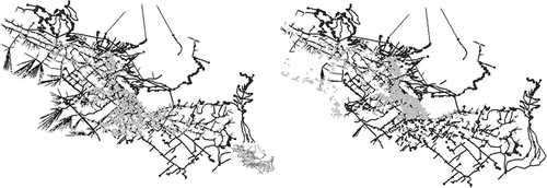
shows the Sarno’s HSPN with dark grey arches representing streets, black arches representing the door links linking buildings and streets’ junctions and squared light grey points representing building’s nodes. It can be clearly observed that some light grey points are removed when moving from the left to the right figure. This means that after the earthquake occurrence, buildings represented by those grey points were damaged, hence unusable, and removed from the HSPN. Analogously, the same can be observed for arches representing streets, although this could seem less evident due to the minor number of damaged street in the proposed scenario analysis.
shows the results in terms of the HSPN’s global efficiency between couple of citizens, E, before and soon after the earthquake occurrence; the recovery function in the immediate aftermath of any event, Y(0); the systemic damage in the aftermath of the event, D(0); and the damage-independent resilience indicator, RE; and damage-dependent seismic resilience, RD.
Table 1. Analysis’ results for the Sarno’s HSPN subjected to 0.25 g earthquake.
Note that results presented in are related to variables defined in [0,1]. Hence, for instance, Y(0) = 0.04 means that the residual HSPN’s efficiency is 4% compared with the pre-event efficiency level. Paralleling, D(0) = 0.96 means that 96% of the city is damaged.
Damage-independent resilience is a useful metric that enables us to compare urban environments with different features. We can also consider resilience to diverse event’s typologies. On the other hand, damage-dependent resilience enables us to assess a city’s capability to recover from a specific disaster accounting for its initial state of damage. This provides a useful guide as to the amount of resources needed to recover to the pre-event equilibrium condition.
3.2. Synthetic cities’ HSPN against shape and size
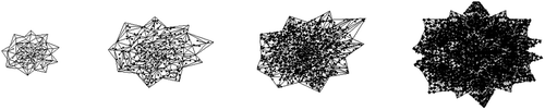
Four different cities’ shapes are artificially built up as HSPNs referring to the planimetry of real, existing urban centres, such as Barcelona, Paris and Los Angeles. In particular, rectangular, circular, hexagonal and star-shaped HSPNs are modelled with their size being increased according to their geographical extent and number of buildings, hence to the number of citizens living in it. Particularly, HSPNs with 50 (about 2000 inhabitants), 200 (about 9000 inhabitants), 1250 (about 55,000 inhabitants) and 5000 buildings (about 225,000 inhabitants) are modelled. For each of them, the city’s connectedness between residential buildings, i.e. pair of citizens being fed from the street urban service, is assessed.
As an example, shows the scaling for the star-shaped HSPN.
Figure 2. Example of scaling in the case of star-shaped city with 50, 200, 1250 and 5000 residential buildings.
Results in terms of the HSPN’s global efficiency between residential buildings, E, and resilience, being evaluated either as dependent on the initial state of damage, RD, or not, RE, are shown in and .
Table 2. Results for each HSPN’s shape and size in terms of the global efficiency before the earthquake occurrence and soon after it, and the recovery function and systemic damage values in the aftermath of the event in the two case analyses.
Table 3. Analysis’ results for each HSPN’s shape and size in terms of the median damage-independent and damage-dependent resilience in the two case analyses.
Low variations across HSPNs’ shapes and sizes are observed in terms of the damage-independent resilience metric. This is due to the nature of the proposed metric. In fact, damage-independent resilience accounts for urban density in terms of the number of street edges, buildings, citizens and relative distances between them. In addition, such information partially affects the metric, being normalised with respect to the whole urban network. Furthermore, the lesser variations observed with the cities’ sizes are due to synthetic HSPNs having been scaled proportionally in space with the increasing number of buildings and streets progressively added. On the other hand, damage-dependent resilience shows higher discrepancies, also exhibiting an increasing trend with the HSPNs’ size. This is due to the higher damage level suffered by bigger HSPNs, which results in a higher number of citizens to be relocated and a higher number of streets and buildings to be restored. Moreover, the lower variability of the damage-independent resilience metric is due to its normalisation, which is done with respect to the slope between the pre- and the post-event efficiency. Hence, in this case, the initial efficiency of the HSPN is not accounted for.
The damage-dependent resilience metric, instead, is assessed by integrating the systemic damage parameter, which is normalised only with respect to the pre-event efficiency level. With this, the HSPNs’ capability to ‘bounce back’ to the pre-event equilibrium is assessed while contextually considering the impact of the seismic event, which is represented by the magnitude of the post-event efficiency.
3.3. Discussion
Despite the traditional approach to urban damage assessment, which typically focuses on single building damages, the current study proposes a framework that enables us to assess structural damages to the whole urban environment with a systemic perspective. This is necessary to assess urban functionalities with a human-centric approach, while monitoring resource use and the efficiency of urban services to ensure sustainability and resilience. According to the proposed approach, buildings and street nodes are conceived as reference points, as the places where citizens live and which they are served from. With this approach, it is possible to perform a measurement of the pre- and post-event performance of the city.
The systemic damage can be simply evaluated according to Equation (7), where it can be noticed that whenever Epre = Epost the ascertained damage is zero, D = 0. Conversely, the systemic damage is observed to be maximised whether Epost = 0, meaning that no residual efficiency remains after the earthquake, i.e. the city is totally disrupted.
The proposed metrics are iterated for each of the stages of the hypothesised recovery strategy. This enables us to monitor urban progress during recovery in terms of efficiency and reallocated citizens.
shows the results in terms of the systemic damage assessment in the two scenarios, that is, the earthquake simulation for HSPNs with different shapes and increasing sizes, assuming first 15% buildings to collapse and then 30% buildings to collapse, and earthquake’s simulation for city of Sarno, assuming buildings’ vulnerability to be consistent with the literature’s fragility curves. Note that in this last case study of Sarno, probability values obtained from the curves cause about 16% of masonry buildings and 5% of RC buildings to collapse.
Table 4. Analysis’ results for HSPN’s shape and size and Sarno case studies in terms of the median systemic damage, D(0).
When focusing on the scenarios with 1250 buildings, the results in terms of the systemic damage show clear correspondence to the results from the Sarno’s seismic scenario, which has similar dimensions. In terms of the number of citizens, one can observe that about 50,000 inhabitants are accounted for in the 1250 buildings’ HSPNs, while in Sarno, about 32,000 inhabitants are estimated, so the two examples are similar in terms of the order of magnitude.
Nonetheless, when looking at damages, Sarno exhibits an evaluated systemic damage immediately after the event, D(0) = 0.96, which is considerably higher than in the case of artificial HSPNs, in which 15% collapsed buildings is assumed. Indeed, D is as high as it can be compared with the HSPNs’ case analysis, in which 30% collapsed buildings is assumed.
In terms of the assessed resilience, both the damage-independent resilience (RE = 0.45) and the damage-dependent resilience (RD = 0.56) results are similar to that of the 30% collapsed buildings case analysis. When analysing results for the HSPNs with 1250 buildings, and evaluating the median over all the considered shapes, resilience indicators are RE = 0.45 and RD = 0.54, respectively.
In regard to the artificial HSPN case studies, resilience trends are also studied against the scale. Particularly, it is observed that the damage-dependent resilience against the HSPNs’ size increases as shown in the histograms in . Hence, while increasing HSPN’s size, resilience also increases progressively, despite some fluctuations that can be observed. This outlines the importance of hierarchies and consequently the issues of scale as outlined in the literature by Batty (Citation2008, Citation2009), Bettencourt et al. (Citation2007) and Salat (Citation2016).
Figure 3. Histograms of damage-independent resilience (left column) in the case of 15% collapsed buildings (upper graph) and 30% collapsed buildings (lower graph); and damage-dependent resilience (right column) in the case of 15% collapsed buildings (upper graph) and 30% collapsed buildings (lower graph).
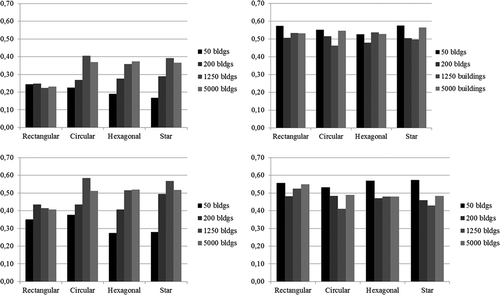
According to Bettencourt, in fact, urban dynamics, such as the interrelations between citizens and urban services, are ruled by economies of scale. The exception to the rule is the case of damage-independent resilience, which does not exhibit the aforementioned behaviour. In this case, resilience does not show a clear trend with the city’s size; on the other hand, low variability is also observed from size to size.
Furthermore, differing levels of resilience (RD and RE) are observed with regards to the HSPNs’ shape for the two case analyses. Conversely, when comparing the two metrics, diverse results are highlighted.
Where either 15% or 30% collapsed buildings is assumed, the rectangular HSPN results to be the most resilient according to the damage-independent metric, while star- and hexagonal-shaped HSPNs are the most resilient according to the damage-dependent resilience metric. In conjunction with this, it should be considered that in terms of the pre-event efficiency, comparisons are reliable when dealing with all HSPNs’ shapes, although the rectangular shape is the exception due to its lower initial efficiency.
Furthermore, while for the smaller HSPNs case studies, the estimated systemic damage is comparable between the star- and the rectangular-shaped HSPNs, a major drop is observed with increasing size. Indeed, for bigger HSPNs (1250 and 5000 buildings) the systemic damage is higher for the star-shaped HSPN, which is why it appears to be the most efficient when calculating damage-dependent resilience. On the other hand, the rectangular HSPN seems to be the most resilient according to the damage-independent metric as despite its low pre-event efficiency, it exhibits greater robustness to the earthquake occurrence thanks to lower post-event systemic damage and, consequently, a smaller efficiency drop compared with other HSPN shapes.
4. Conclusions
Contemporary cities emerge as complex systems where physical and social components coexist and are strictly interrelated. Building sustainable cities while enhancing their resilience to catastrophic natural and human-induced events is therefore a major issue.
A particular focus is here put on natural events like earthquakes. When an earthquake occurs, it hits urban physical components and the services they supply to citizens. As a consequence, severe injuries to the human component are observed too. This cascading effect primarily affects the quality of life of citizens in terms of their satisfaction with the efficiency of urban services and facilities.
The methodology adopted in this paper aims to quantify the level of resilience of urban centres, specifically their coping capacity and robustness to earthquakes after different levels of damage. Two diverse resilience metrics are proposed and evaluated, the former being independent of the initial state of damage after the seismic event occurrence, and the latter being dependent on it.
First, the city is modelled as HSPNs, which account for both physical and social components. Then scenario analyses are performed for the real case study of Sarno and 16 artificially modelled HSPNs with diverse shapes and sizes. Furthermore, comparisons are performed between HSPNs’ shapes and sizes, with regards to damage-dependent and damage-independent resilience. The proposed framework has the potential to be applied to a multiplicity of case studies focusing on several diverse urban features and urban risks. The quantification of resilience is based on the efficiency assessment of the city functioning and feeding citizens through focal supply nodes.
Experimental results show a clear decline of the HSPNs’ efficiency in the aftermath of the seismic event, which is gradually recovered. Obviously, the more intense the earthquake, the more buildings and streets are damaged, and the more citizens are reallocated too.
The robustness of the proposed framework is underlined. In fact, the model results to be consistent with the real case study city (the Sarno HSPN), therefore proving its validity as one way to project possible damage to and resilience of urban form. As a result, comparable results are observed when observing the real HSPN of Sarno and artificial HSPNs with a similar number of citizens and buildings.
Moreover, urban form reveals having a significant impact on urban efficiency in terms of service delivery and on urban resilience after a natural disaster. In particular, a ‘star’ HSPN shape and a rectangular HSPN shape exhibit the greatest resilience. Although, this is partially because they do not have to return to such efficient equilibria, and partially because they do not experience the same level of systemic damage as more typical circular or hexagonal HSPN shapes.
Based on the observed systemic damage and efficiency in the pre- and post-event phases, the two resilience metrics (damage-independent and damage-dependent) seem to be collaterals. The former enables us to compare the resilience of different urban environments to diverse events. The latter enables us to assess a city’s capability to recover from varying levels of damage. As a consequence, contextual observation of such metrics is recommended. A particular focus is put on the capability of the damage-dependent resilience metric to compare cities vulnerable to the same kind of event and located within a comparable context. Keeping with this, urban resilience can be effectively assessed in terms of the changing levels of efficiency in the pre- and post-event phases. This also has implications for the social and economic sustainability of a vulnerable city.
This paper sheds light on the scope for optimisation of the recovery process in the aftermath of a catastrophic event. It demonstrates the role that urban form and function can play in reducing the level of damage and increasing the rate of recovery. By optimising the recovery process, planners and policymakers can, therefore, enhance the resilience of urban infrastructure and citizens.
Disclosure statement
No potential conflict of interest was reported by the authors.
Additional information
Notes on contributors
Anna Bozza
Anna Bozza is a structural engineer who recently completed her PhD degree in Materials and Structures Engineering at the University of Naples ‘Federico II’, supported by a grant from the Italian Ministry of Education, University and Research. Her research topics focus on probabilistic risk assessment, quantification of urban disaster resilience, probabilistic assessment of expected losses, characterisation of insurance and reinsurance models for the building stock.
Domenico Asprone
Domenico Asprone is Assistant Professor of Structural Engineering at the University of Naples ‘Federico II’ and Associate Researcher at the Institute for Complex Systems (ISC), Italian National Research Council (CNR). His research interests focuses on seismic engineering, risk engineering, disaster resilience, integration of sustainability in construction industry and urban environment. Dr Asprone has been coordinator of different research projects.
Gaetano Manfredi
Gaetano Manfredi is Full Professor of Structural Engineering at the University of Naples ‘Federico II’ since 2000 and Chancellor of University of Naples Federico II, from 2014 to present. He is member of diverse scientific Institutions, such as EERI, FIB, ASCE, ACI, ISO and ASCE Journal of Composites for Constructions Editorial Board. He is Editorial Reviewer for many international journals, and an expert of the Italian Ministry of University and Research for supporting the scientific research (D.L. 297/99).
References
- Adger WN. 2000. Social and ecological resilience: are they related? Prog Hum Geogr. 24:347–364.
- Ahmad N, Crowley H, Pinho R 2011. Analytical fragility functions for reinforced concrete and masonry buildings aggregates of euro-mediterranean regions – UPAV methodology. Internal report, Syner-G Project, 2009/2012.
- Asprone D, Manfredi G. 2015. Linking disaster resilience and urban sustainability: a glocal approach for future cities. Disasters. 39:s96–s111.
- Batty M. 2008. The size, scale, and shape of cities. Science. 319:769–771.
- Batty M. 2009. Urban modeling. International encyclopedia of human geography. Oxford (UK): Elsevier.
- Berche B, Von Ferber C, Holovatch T, Holovatch Y. 2009. Resilience of public transport networks against attacks. Eur Phys J B. 71:125–137.
- Bettencourt LMA, Lobo J, Helbing D, Kuhnert C, West GB. 2007. Growth, innovation, scaling, and the pace of life in cities. Proc Natl Acad Sci USA. 104:7301–7306.
- Bozza A, Asprone D, Manfredi G. 2015a. Developing an integrated framework to quantify resilience of urban systems against disasters. Nat Hazards. 78(3):1729–1748.
- Bozza A, Asprone D, Fiasconaro A, Latora V, Manfredi G. 2015b. Catastrophe resilience related to urban networks shape: preliminary analysis. In: Papadrakakis M, Papadopoulos V, Plevris V, editors. COMPDYN 2015: 5th ECCOMAS thematic conference on computational methods in structural dynamics and earthquake engineering; Crete, Greece.
- Bruneau M, Chang SE, Eguchi RT, Lee GC, O’Rourke TD, Reinhorn AM, Shinozuka M, Tierney K, Wallace WA, von Winterfeldt D. 2003. A framework to quantitatively assess and enhance the seismic resilience of communities. Earthquake spectra. 19(4):733–752.
- Cavallaro M, Asprone D, Latora V, Manfredi G, Nicosia V. 2014. Assessment of urban ecosystem resilience through hybrid social–physical complex networks. Comput-Aided Civ Infrastruct Eng. 29:608–625.
- Cumming GS, Barnes G, Perz S, Schmink M, Sieving KE, Southworth J, Binford M, Holt RD, Stickler C, Van Holt T. 2005. An exploratory framework for the empirical measurement of resilience. Ecosystems. 8:975–987.
- Delgado Ramos GC. 2016. Urban metabolic efficiency, climate change and sustainability. In special issue on linking urban resilience and resource efficiency. Int J Urban Sustainable Dev (IJUSD).
- Dodman D, Diep L, Colenbrander S. 2016. Making the case for the nexus between resilience and resource efficiency at the city scale. Int J Urban Sustainable Dev (IJUSD).
- Floater G, Rode P, Robert A, Kennedy C, Hoornweg D, Slavcheva R, Godfrey N 2014. Cities and the new climate economy: the transformative role of global urban growth. Contributing paper for better growth, better climate. New Climate Economy. Available from: http://newclimateeconomy.report/misc/working-papers
- Folke C. 2006. Resilience: the emergence of a perspective for social–ecological systems analyses. Global Environ Change. 16:253–267.
- Franchin P, Cavalieri F. 2013. Seismic vulnerability analysis of a complex interconnected civil infrastructure. In: Tesfamariam S, Goda K, editors. Handbook of seismic risk analysis and management of civil infrastructure systems. Cambridge (UK): Woodhead Publishing.
- Franchin P, Cavalieri F. 2015. Probabilistic assessment of civil infrastructure resilience to earthquakes. Comput-Aided Civ Infrastruct Eng. 30:583–600.
- Garmezy N. 1973. Competence and adaptation in adult schizophrenic patients and children at risk. In: Dean SR, editor. Schizophrenia: the first ten dean award lectures. New York (NY): MSS Information Corporation.
- Gouldson A, Colenbrander S, Sudmant A, Godfrey N, Millward-Hopkins J, Fang W, Zhao X. 2015. Accelerating low-carbon development in the world’s cities. Contributing paper for seizing the global opportunity: partnerships for better growth and a better climate. New Climate Economy. Available from: http://newclimateeconomy.report/misc/working-papers
- Gunderson L. 2010. Ecological and human community resilience in response to natural disasters. Ecol Soc. 15:18.
- Gunderson L, Holling CS, Pritchard L, Peterson G. 2002. Resilience. In: Mooney H, Canadell J, editors. Encyclopedia of global environmental change, 2. Paris: Scientific Committee on Problems of the Environment; p. 530–531.
- Holling CS. 1996. Engineering resilience versus ecological resilience. National Academy of Engineering. Engineering Within Ecological Constraints. Washington (DC): The National Academies Press, 1996. doi:10.17226/4919. p. 31–44.
- Holling CS. 1973. Resilience and stability of ecological systems. Annu Rev Ecol Syst. 4:1–23.
- ISTAT. 2011. 14° Censimento generale della popolazione e delle abitazioni. Roma: ISTAT.
- Latora V, Marchiori M. 2001. Efficient behavior of small-world networks. Phys Rev Lett. 87:art. no. 198701.
- Leu G, Abbass H, Curtis N. 2010. Resilience of ground transportation networks: A case study on Melbourne. Paper delivered at the 33rd Australasian Transport Research Forum Conference, Canberra, Sep 29–Oct 1.
- Leung D, Law W, Hills P, Lo A. 2016. Resource use, personal consumption and environmental impacts of economic growth: some lessons from China. In special issue on linking urban resilience and resource efficiency. Int J Urban Sustainable Dev (IJUSD).
- Lotka AJ. 1925. Elements of physical biology. Baltimore (MD): Williams and Wilkins. (Reprinted 1956, Dover, New York).
- Mensah AF, Dueñas-Osorio L. 2015. Efficient resilience assessment framework for electric power systems affected by hurricane events. J Struct Eng. C4015013. ASCE.
- Milgram S. 1967. The small world problem. Psychol Today. 2:60–67.
- Murray-Tuite PM. 2006. A comparison of transportation network resilience under simulated system optimum and user equilibrium conditions. In: Simulation conference, 2006. WSC 06. Proceedings of the winter. IEEE; p. 1398–1405.
- Newman PWG, Kenworth JR. 1991. Transport and urban form in thirty-two of the world’s principal cities. Transport Rev. 11:249–272.
- Ouyang M, Dueñas-Osorio L. 2014. Multi-dimensional hurricane resilience assessment of electric power systems. Struct Saf. 48:15–24.
- Peter C. 2016. A review of resource efficiency in sub-Saharan African cities. In special issue on linking urban resilience and resource efficiency. Int J Urban Sustainable Dev (IJUSD).
- Pfeiffer K. 1929. Untersuchungen uber die Resilienz der durch die Prothesen beanspruchten Gewebe und ihre Bedeutung fur die Okklusion der Prothesen. Zurich: Berichthaus.
- Pimm S. 1984. The complexity and stability of ecosystems. Nature. 307:321–326.
- Plummer R, Armitage D. 2007. A resilience-based framework for evaluating adaptive co-management: Linking ecology, economics and society in a complex world. Ecol Econ. 61:62–74.
- Renschler CS, Frazier AE, Arendt LA, Cimellaro GP, Reinhorn AM, Bruneau M. 2010. Developing the ‘PEOPLES’ resilience framework for defining and measuring disaster resilience at the community scale. In: Proceedings of the 9th US national and 10th Canadian conference on earthquake engineering (9USN/10CCEE); Toronto. p. 25–29.
- Salat S. 2016. Scale hierarchies in resilient and resource efficient urban spatial structures. In special issue on linking urban resilience and resource efficiency. Int J Urban Sustainable Dev (IJUSD).
- Todini E. 2000. Looped water distribution networks design using a resilience index based heuristic approach. Urban Water. 2:115–122.
- Werner E. 1971. The children of kauai. A longitudinal study from the prenatal period to age ten. Honolulu: University of Hawaii Press.
- Zhou HJ, Wan JH, Jia H. 2010. Resilience to natural hazards: a geographic perspective. Nat Hazards. 53:21–41.