
ABSTRACT
The increase in human activities in urban areas resulting from the urbanisation process continues to put immense pressure on urban ecological resources including water bodies. This study seeks to assess the relationship between the various categories of human activities within the 100 m buffer of the major water bodies in the Kumasi Metropolis and the chemical and biological composition of the pollutants that are emitted into the water bodies. The findings of this study showed that the Kumasi Metropolis is confronted with weak enforcement of regulations that protect water bodies. For example, along the Subin River, human activities such as commercial activities and the development of squatter settlements did not conform to the standard setback average distance of 100 feet in the Zoning Regulation and Planning Standards. There is a need for city authorities to strategically respond to the various human activities that threaten the sustainability of water resources in cities.
1. Introduction
Globally, the rate of urbanisation continues to increase unabatedly as rural dwellers continue to seek economic success and livelihood opportunities inherent in towns and cities. Rapid urban population growth has aggravated the demand for land for new development. Nonetheless, the supply of land is fixed, thus, increasing competition for it among various land uses. This competition has made land, irrespective of its quality, relevant in the urban space (Zhang Citation2016). Rapid urbanisation, coupled with the ongoing land crisis, has heightened the encroachment of and extinction of public open spaces and ecologically sensitive areas (Cobbinah and Niminga-Beka Citation2017; Korah et al. Citation2017; Brandful et al. Citation2021; Cobbinah and Nyame Citation2021). Globally, water resources such as streams, rivers, lakes, and ponds among other water bodies have been identified as one of the massively encroached ecological resources (Khatri and Tyagi Citation2015). The consequences of this massive encroachment have resulted in 80% of sewage in developing countries being discharged into water bodies without any form of treatment (UN-WWAP Citation2015). In many countries in SSA, freshwater resources are being polluted by pathogens, heavy metals, chemical components, and emerging pollutants such as organic matter (UNESCO & UN-WWAP, Citation2020). The extent of water pollution continues to be on the rise due to growing human activities within the buffer of water bodies. The level of pollution is even more intense due to increasing and unregulated municipal and industrial discharge of waste into urban water bodies (UN-Habitat Citation2012).
The result of the preceding is that water quality is compromised, making it unsuitable for human consumption and other domestic and commercial uses (UN-Habitat Citation2012). More so, overexploitation or unregulated use of water resources for agriculture and industry purposes has resulted in a surge in physical water scarcity, which has rendered an estimated 1.2 billion of the world’s population without access to water (Petruzzello Citation2020). A ‘doing nothing’ strategy by policy-makers and city authorities would aggravate the current situation. Following this, there has been a global call as enshrined in the UN-Water and Sanitation Decade of the 1980s and the SDGs (Goal 6) to ensure improvement, efficient use, and management of water resources. Despite these global efforts, many countries are still faced with the challenge of balancing urban population growth and its associated human activities with the preservation and protection of water resources (Obiri-Danso et al. Citation2005; Filho Citation2015).
As the urban population continues to increase, the demand for treated water for human use continues to grow unabatedly. Nonetheless, countries in the global south have not kept to the pace of the increasing demand due to financial constraints and inadequate water infrastructure to adequately treat water (Obiri-Danso et al. Citation2005). The inability to sufficiently treat and manage the available water resources has contributed significantly to the global economic water scarcity, which currently stands at 1.6 billion (Petruzzello Citation2020). In the global south, an estimated 1.2 billion people are challenged by water stress and land insecurity due to high poverty levels. A more significant proportion of them are found in Sub-Saharan Africa (SSA), south and south-eastern Asia, and Latin America levels (Nkonya et al. Citation2012).
In SSA, rapid urban growth continues to aggravate conditions for unplanned and unregulated use of land and water resources. In addition to population increase, high poverty levels, poor governance, weak institutions, and outmoded land use regulations and policies have contributed significantly to the abuse of water resources in many countries in SSA (Ahmed and Dinye Citation2012; Attua et al. Citation2014; Eduful and Shively Citation2015). According to Ghana’s Environmental Protection Agency (2003), 68.8% of the country’s water bodies are heavily polluted (Coffie Citation2014). Statistics from the Agency further revealed that 6% of the country’s surface water bodies are unpolluted or undergoing natural purification. Aside from the country’s heavy reliance on biological purification of surface water bodies, it lacks the needed infrastructure and resources to adequately treat contaminated water resources to meet the growing demand for water (Owusu-Ansah et al. Citation2015). The situation leaves over 5 million people in the country who depend on surface water bodies (Ministry of Water Resource Works and Housing Citation2007) vulnerable to water-related diseases. Amid the persistent nature of the challenges mentioned above, the country’s ability to achieve the SDG 6 (Target 6.1 and 6.3) and SDG 11 is far from reality unless an alternative and more holistic approach is adopted. It is imperative, therefore, to discuss how urbanisation can co-exist with/against the effective management of surface water resources.
The ability of city authorities and policy-makers in the Ghanaian context to achieve sustainable city development will rely on their ability to effectively manage water resources from a holistic perspective by understanding the extent of water pollution in cities, exploring land-use dynamics and water resources regulations; and how they influence the quality of water resources. In the conventional literature, this dimension that has received a lot of attention in the form of research is the type and level of pollutants and the extent to which they affect water quality (example Iddrisu Citation2012: Miezah et al. Citation2015; Tutu and Stoler Citation2016; Darko et al. Citation2022). Also, researchers such as Monney et al. (Citation2013) studied the physicochemical and biochemical pollution status of the Kole Lagoon and the Aboabo River to determine the types of pollutants in these water bodies. Asare-Donkor, Wemegah, and Adimado (Citation2013), on the other hand, conducted research on the chemical analysis of freshwater bodies in the Kumasi Metropolis. This study used physiochemical parameters to determine the degree of chemical pollution in water bodies such as Wiwi, Sisa, and Subin in the Kumasi Metropolis. Danquah, Abass, and Nikoi (Citation2011) further assessed the quality of the Aboabo River and the anthropogenic factors leading to the pollution of the water body. Finally, the research by Ahmed and Dinye (Citation2012) focused on land use activities along the Subin and Aboabo Rivers. What seems to be missing or unclear in the existing literature is the interconnection between various land uses/human activities and the multiple pollutants found in the water bodies. This will therefore help improve upon the already existing literature by studying the relationship between specific activities along the major river bodies in the Kumasi Metropolis and the quality of water.
2. Nature and consequence of urbanisation in the global south and Ghana
The West African country of Ghana is the fastest urbanising country next to the Republic of Burkina Faso and Nigeria (Ayambire et al. Citation2019; United Nations Citation2019). However, Burkina Faso and Nigeria are predominantly rural with 27.5% and 47.8% of their population residing in urban areas, respectively, and Ghana, on the other hand, is predominantly urban with an urban population of 54.1% (UNDESA/PD, Citation2019). The urban population in Ghana has consistently increased over the years and, in 2010, toppled the rural population (49.1% of the total population). In 2018, Ghana was ranked ninth in Africa and third in West Africa with an urban population level of 56%, representing a 33% increase in the urban population in 1960 (Songsore Citation2009; Ghana Statistical Service Citation2014; UNDESA/PD, Citation2019). Its urban population is expected to increase to 73.2 by 2050 (UNDESA/PD, Citation2019). The unprecedented rate of urban growth in Ghana coupled with challenges such as increasing poverty levels, weak public institutions, and poor law (Mishra Citation2011; Ahmed and Dinye Citation2012; Amoateng et al. Citation2018; Azerigyik et al. Citation2018) has resulted to several water resources being threatened by massive encroachment for various socio-economic activities, pollution, and unregulated water use (Ahmed and Dinye Citation2012; Attua et al. Citation2014; Eduful and Shively Citation2015). The impact of urbanisation in Ghana is not only felt in surface water bodies but also in other ecosystems such as wetlands and urban green spaces. Brandful et al. (Citation2021), Cobbinah and Nyame (Citation2021), and Narh et al. (Citation2020) have highlighted how urbanisation in Ghana is causing a significant decline in wetlands and UGS. According to the Ministry of Water Resources Works and Housing (Citation2011), the changing needs of communities due to increasing urban population growth has resulted in river population and degradation of buffer zones especially for rivers which flow through and close to settlements that are densely populated. In Ghana, highly urbanised areas such as Kumasi and Accra have become incubators of rapid freshwater, wetlands, and urban green space decline due to the inability of city managers to protect these resources. Brandful et al. (Citation2021) revealed that wetlands within the city of Kumasi are faced with extinction due to the manifestation of land use modifications which is a major driver of fast wetland and green space decline. According to Amoateng et al. (Citation2018), Ghana’s fastest urbanising city, Kumasi, has lost 83% rivers and floodplains between 1985 and 2013 due to rapid urban population growth. This therefore makes Ghana an ideal case for a study that purpose of examining the various land uses across water bodies and what it means when it comes to the quality of water. Further, given the similarities in the urbanisation experience of countries in Sub-Saharan Africa, the results could have policy implications for the entire region.
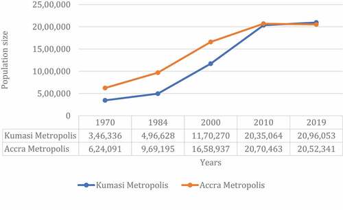
Currently, Ghana’s urban population is concentrated in 64 cities, with Accra and Kumasi being the only cities with populations over one million (Ghana Statistical Service (GSS), Citation2013). Based on the population of these cities, they were declared among the 85 medium-sized cities (i.e., cities with an urban population of between 1 and 5 million) globally (UNDESA/PD, 2019). Statistics from the Ghana Statistical Service (GSS) indicate that the urban growth of Accra and Kumasi continues to increase rapidly (see ). Cobbinah and Erdiaw-Kwasie (Citation2018) and Ghana Statistical Service (Citation2014) revealed that Accra was noted to be the most urbanised city in Ghana but has gradually been toppled by Kumasi in recent times by 2.1% (see ). In 2010, Kumasi was considered the fastest urbanising city in Ghana, contributing 20.2% (10.6% more than Accra) to the urban growth of the country. Ghana Statistical Service (Citation2014), the population density of the Kumasi Metropolis is 8,075 persons per sq. km compared to the national population density of 124 people per sq. km (Ghana Statistical Service Citation2013). These results show the level of pressure on land resources in the Kumasi Metropolis, thus resulting in the continuous use of lands around water bodies in the metropolis for residential, industrial, educational, and commercial activities. Studies on the effects of rapid urbanisation on the environment (see Brandful et al. Citation2021) indicate that the city’s wetlands, for example, are gradually being depleted due to the conversion of wetlands into residential. According to Koranteng et al. (Citation2020), residential land uses have increased from 13,596 hectares in 1990 to 70,638.63 hectares in 2020. This boom has resulted in the decline of the spatial coverage of rivers. This makes Kumasi Metropolis a suitable case for exploring the Ghanaian context of the management practices of various land uses within the buffer of water bodies.
Figure 1. Urban population trend of Accra and Kumasi (1970–2019).
3. Material and methods
The multi-faceted nature of urban environmental problems has led to various scholars calling for the need for a multidisciplinary approach to solving these problems. This study, therefore, explores the effects of land-use activities on the quality of water bodies in the Kumasi Metropolis from a multi-disciplinary perspective. The methodological approach adopted for this research include land use analysi and chemical and biological analysis.
3.1. Description and justification of selected water bodies
As indicated earlier, the area under study is the Greater Kumasi Metropolitan Area (GKMA). It is located in the southeastern part of the Ashanti region of Ghana. The metropolitan area, which has a total land area of 299 km2, is approximately 270 km north of the national capital, Accra. The study was carried out along two water bodies purposely selected from GKMA. Before these rivers were selected, all water bodies that join the River Oda downstream at the southern part of the Greater Kumasi Metropolis were considered and stratified into urban and peri-urban water bodies (see ). Water bodies categorised as urban were based on their relative proximity to or the traverse through Central Kumasi (hereinafter can be used interchangeably as CBD). On the other hand, water bodies that traverse through peri-urban communities, hence not within or flowing through Central Kumasi, were categorised as peri-urban water bodies (see ). Water bodies that flow through or within the Central Kumasi were noticed to have a higher intensity of pollution as compared to water bodies far from the CBD. More so, peri-urban water bodies by their location were observed to have low land use density relative to water bodies that flow within the CBD. From each stratum, a water body was purposely selected for the study. The water bodies selected for this study were the Rivers Subin and Wiwi from the stratum urban and peri-urban, respectively. These water bodies were selected from the list of water bodies because of their unique features and land uses they exhibit compared to other water bodies in their category.
Figure 2. Location of the rivers Wiwi and Subin in the greater Kumasi Metropolis.
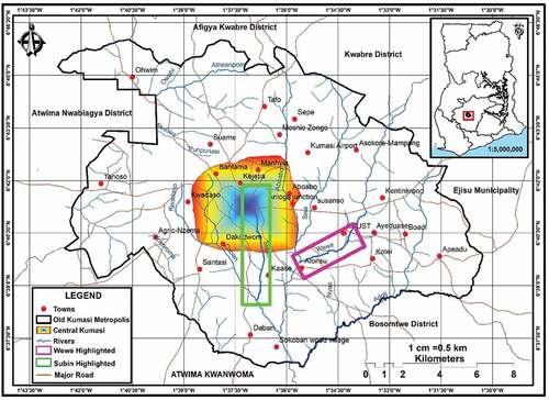
Table 1. Stratification of water bodies in the greater Kumasi Metropolis.
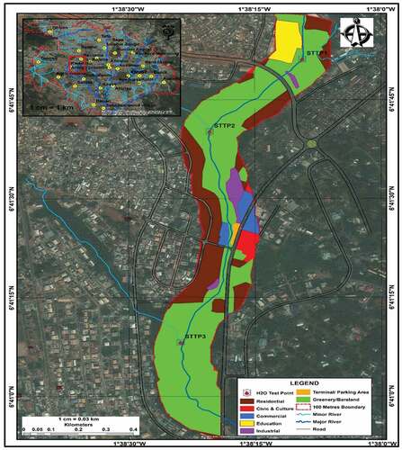
Even though the River Subin shared similar land uses with water bodies such as the Rivers Aboabo and Suntre, it stands out because it flows through the centre of the metropolis, where major commercial and industrial activities take place. The city centre is the hub of several small and large-scale industries, including palm kernel oil extraction, charcoal-producing business, metal scrap dealers, leather tanning industries, car washing bays, among others (Tobergte & Curtis, Citation2013). Also, the proximity of the largest and only tertiary hospital (Komfo Anokye Teaching Hospital (KATH)) in Greater Kumasi Metropolis to the Subin River makes it unique. Untreated wastes from the Teaching Hospital and the industries end up in the river (Ahmed and Dinye Citation2012). The result poses adverse repercussions for human and environmental health. The Subin River is well known as it takes its source from the centre of the city. A unique characteristic of the drainage system in Kumasi is a concrete drain that was superimposed on the Subin River to avert flooding in the town.
For peri-urban water bodies, it was observed that they had land uses such as residential, commercial, agricultural, greenery, and undeveloped land along them. However, the River Wiwi showed unique land-use features that differentiated it from the other water bodies. The water body flows through the only botanical garden (KNUST Botanical Gardens) and largest tertiary educational institution (Kwame Nkrumah University of Science and Technology (KNUST)) in GKMA. These land uses are likely to influence the type and level of contaminants in the water body.The landuses along River Subin and River Wiwi have been presented in respectively.
Figure 3. Land uses along the River Wiwi.
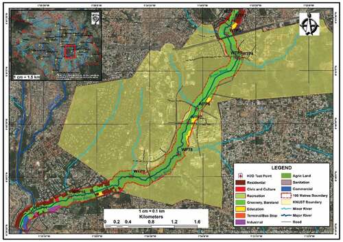
Figure 4. Land uses along the River Subin.
3.2. Source of data and methods of data collection and analysis
This research relied on both primary and secondary data sources. The primary data used for this study was obtained through field observation, collection of water samples, and mapping of land uses within 100 feet of the selected water bodies in the GKMA of Ghana. Details of the mapping strategy have been discussed in Section 2.3 of the paper. The secondary data on the other hand were used to supplement the primary data to provide an in-depth understanding of the nexus between the various land uses and physical and chemical composition/contaminants of water bodies in the GKMA. The secondary data was obtained from sources such as journal articles, review reports, and online sources such as web pages of institutions relevant to the study.
3.3 Mapping of land use activities along rivers Wiwi and Subin
The geographical coordinates of various land uses within the buffers of the selected water bodies were captured using a GPS application on a mobile phone (Handy GPS) with 2–5 meter real-time accuracy in July 2019. The GPS coordinates of adjoining land uses within a range of 100 feet on each side of the water bodies were collected to facilitate easy mapping. The 100 feet buffer range is in line with the standard setback average distances for a buffer zone, as stipulated by the Zoning Guidelines and Planning Standards and the Water Resource Commission of Ghana. The mapping was done by first establishing Water Set-up Points (WSP). The variation and intensity of land use along the water bodies and their tributaries influenced the setting up of these points. A total of 20 sets up points were established (River Wiwi = 12 set-up points and River Subin = 8 set-up points). The field observation revealed that there were different types of land uses within the 100 feet buffer of the two water bodies, with the most common ones being residential, commercial, industrial, farmland, greenery/bare land, and sanitary (see ). The coordinates of the Water Set-up points and the various land use activities were recorded in an observation checklist.
Table 2. Land uses along sampled water bodies.
3.4 Chemical and biological analysis of water bodies
The chemical and biological analyses conducted in this study include physicochemical parameters, nutrient load, heavy metals, and coliform counts. The researchers collected water samples from the tributaries of Wiwi and Subin. Overall, a total of 20 sets up points were established with the researchers studying 12 set-up points and 8 set-up points on the River Wiwi and the River Subin, respectively. The water samples were collected into clean white transparent plastic containers that have been sterilised with 10% v/v nitric acid, dilute potassium permanganate solution and rinsed with a lot of distilled water and properly labelled. The pH and temperature measurements of the water samples were taken on site with a portable pH metre and thermometer. The surface sediments were also collected at the same spots where water samples were collected into sterilised transparent polyethylene bags, tied and labelled. All the samples were placed in a cool ice chest for onward transport to the laboratory, where they were transferred to a refrigerator prior to analysis. Overall, physicochemical parameters such as pH, turbidity, total suspended solids, alkalinity, electrical conductivity, hardness, Mg2+, Ca2+, Cl-, chemical oxygen demand, biochemical oxygen demand, and dissolved oxygen were assessed. Additionally, physicochemical properties of the surface sediments, such as pH and conductivity, were determined. The water, and surface sediments were analysed for the following heavy metals using the atomic absorption spectrophotometer: Fe, Zn, Cu, Pb, Mn, Cd, and Hg.
4. Results and discussion
Santhanam and Majumdar (Citation2022) note that the increasing pressure on ecological resources, especially water bodies in urban centres, may be linked to the increased urban sprawl and a consequent increase in the impervious surfaces across the urban centres. The level of pressure on land is relatively high in the Greater Kumasi Metropolis. Thus, it has led to the exploitation of land resources within the 100 feet buffer of water bodies in the city for various human activities. This practice is a violation of the Zoning Guidelines and Planning Standards of Ghana. The result of the study as shown in shows that the major land uses that have encroached into the buffer of the Rivers Subin and Wiwi were agricultural, residential, and commercial land uses. It must be noted that the waste water from these land uses are discharged into the water bodies without any form of treatment and this threatens the sustainability of the water bodies (Ahmed and Dinye Citation2012; Darko et al. Citation2022).
4.1 The effects of residential and public infrastructural land uses on the quality of water bodies
As indicated in , the results of the study indicated that land uses categorised under residential and infrastructural (residential, education, terminal/parking areas, sanitation, recreation, and road) occupied 20.2% of the aggregate land surface of the two water bodies. A comparative analysis between the two water bodies further revealed that residential and infrastructural land uses were most prominent along the River Subin than the River Wiwi. The dominance of residential and infrastructural land uses along the Subin can be attributed to the fact that it runs through the CBD. In Kumasi, the influx of poor urban migrants has resulted in them living close-knit to the city to engage in economic activities (Takyi et al. Citation2020). Also, they live close to their source(s) of livelihood to reduce/avoid the cost of transportation. Following this, they have become ‘encroachers’ of available open spaces and creators of substandard housing and unsanitary living environment along the water body. The location of the CBD has also necessitated the construction of some social infrastructure to service a wider coverage of the populace of the Greater Kumasi Metropolis. Most of these infrastructures are relatively close to the banks of the River Subin.
The Wiwi River, which traverses peri-urban communities, has also received its share of residential and infrastructure encroachment as development is closing up its banks rapidly. From the field observation, it was revealed that residential and infrastructure development occupied 19% of land use within the buffer of the river. The increase in residential and infrastructure development along the river can be attributed to rapid peri-urban growth and the proximity of the river to the Kwame University of Science and Technology (KNUST). The university and its associated infrastructure development present socio-economic benefits to both indigenes and migrants within the Greater Kumasi Metropolis. Following this, there has been intense pressure on the available land within the confines of the university and adjoining communities such as Ayigya, Ayeduase, and Ahinsan. This has resulted in a high level of encroachment on the River Wiwi. This was evident in the study as it was revealed that 35.4% of the residential developers have their housing units within the buffers of the River Wiwi. The study further revealed that educational land use (such as Wiwiso M/A Basic School, the KNUST Hospital, and academic facilities of KNUST) were also identified along the river.
Conventional literature has confirmed that the two water bodies have been heavily polluted with faecal coliforms over the years. For example, the faecal component in the River Wiwi within a space of 4 months recorded microbial count (9.0 × 10⁴–9.5 ×106,100 ml−1 CFU), which exceeded the WHO (Citation2006) standard of 1.0 × 10³, 100 ml−1 CFU (Amisah and Nuamah Citation2014). The microbial counts in the faecal coliforms in the River Subin also exceeded the standard as stipulated by WHO (Citation2006)(see: Obiri-Danso et al. Citation2005). The microbial count suggests the presence of human sewage (Amisah and Nuamah Citation2014). Aside from the presence of faecal coliforms, Schistosoma haematobium has been identified to be present in the Wiwi River (Sammy et al. Citation2013). The cause of this infectious disease is the dumping of human waste into water bodies (Black Citation2008), which could be explained by the massive residential and infrastructure development.
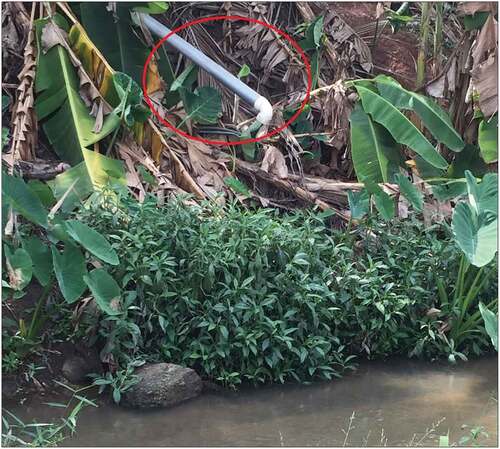
Many housing units along the buffer zones of the water bodies in the city of Kumasi are predominantly temporal and substandard structures. These substandard housing units were mostly located behind the Abinkyi Market (Afia Kobi Market) along the River Subin. The housing quality and lack of proper sanitary facilities have resulted in solid waste being directly discharged into the water bodies. Some housing units were found to have their drains directed into the water bodies where greywater and blackwater were discharged (see ). Through observation, a pile of human excreta was found along the rivers. This phenomenon can be explained by the work of Ahmed and Dinye (Citation2012). They highlighted that 50% of the residents who live in substandard housing (lack toilet facilities) in Kumasi defaecate in or discharge human excreta into the rivers. The forgoing affirms the presence of faecal coliforms in the water bodies.
Figure 5. PVC pipe from a residential facility directed into the River Wiwi.
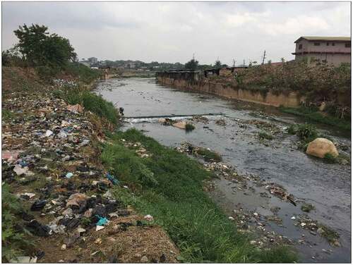
As shown in , Untreated wastewater are mostly discharged into the River Subin and River Wiwi and this has implication for the quality and sustianability of the water bodies. The situation is due to a lack of/non-functional sewage plants (Owusu-Ansah et al. Citation2015). According to Rop (Citation2014), the discharge of waste into river bodies by hospitals is likely to record high levels of Salmonella spp, Biochemical Oxygen Demand (BOD), and Chemical Oxygen Demand (COD). Research work by Obiri-Danso et al. (Citation2005) confirmed high BOD, with values ranging from 8 to 419 mgl−1 in the River Subin which could plausibly be explained by the discharges for KATH.
Figure 6. Residential and infrastructure development and water resource pollution in the City of Kumasi.
The study also showed that some of the wetlands along the various water bodies have been converted into dumpsites. During heavy rains, the refuse from these dumpsites runoff into the water bodies, which consequently affect their quality and also impede the free flow of water. The evidence was confirmed by the study of Melakua et al. (Citation2007). They observed that several streams in urban areas are used as receiving bodies for the discharge of domestic waste by households living close to them (Melakua et al. Citation2007). Some of the waste material observed to be present in the water bodies includes but is not limited to plasticand electronic materials. The availability of these materials could explain the existence of heavy metals (Lead (Pb), Manganese (Mg), Copper (Cu), Iron (Fe), and Zinc (Zn)) in the water bodies as reported by (Mensah et al. Citation2016). The researcher confirmed that some of these heavy metals are above the recommended standard of 0.01 mg/l by the WHO. For example, the average concentration of Lead (Pb) recorded in the Wiwi and Subin Rivers was 0.018–0.031 mg/l and 0.035–0.055, respectively, which is greater than the recommended value. Pb (mg/l). The higher concentration of lead poses a threat to urban dwellers who rely on these water bodies for domestic purposes.
The growing residential and infrastructural development along the water bodies and its associated effects on the quality of water in the Kumasi Metropolis can be attributed to the weak enforcement of the zoning regulations. The lack of development control along the water bodies poses a severe threat to the sustainable management of the water bodies with its associated adverse social, health, and economic effects. This has been supported extensively by conventional literature. For example, in most sub-Saharan African countries, residential development along significant rivers in urban areas has resulted in the concentration of phosphorus and nitrogen beyond the accepted standard in urban water bodies, thereby making the water unsafe for human use (Haddis et al. Citation2014). Also, sewage from residential development along the Wiwi River has contributed to significant S. haematobium infection in the city of Kumasi (Sammy et al. Citation2013). Anecdotal evidence of sanitation-related diseases such as diarrhoea is common in Kumasi as a result of the consumption of vegetables produced from the water bodies, which are high in microbial counts for irrigation purposes (Amisah and Nuamah Citation2014). Considering the high faecal coliforms (that is above the WHO Citation2006 standard) in the water bodies, they are unsuitable for domestic and irrigation of vegetables (Amisah and Nuamah Citation2014).
4.1.1. Urban agriculture along the water bodies
Urban farmers within the GKM are mostly the urban poor. Due to their relatively low income, these farmers encroach the buffer zones of water bodies to utilise the available vacant wetlands and water resource for year-round farming (See ). Also, the inability to enforce land-use regulations and legislation has led to the insurgence of agricultural activities along water bodies (Ahmed and Dinye Citation2012; Okumah et al. Citation2019, Citation2020). The preceding explains the manifestation of agricultural activities/land use (representing 18.6%) 100 feet from the sampled water bodies. Agricultural land use activities are prevalent along the River Wiwi, which flows through peri-urban communities. Peri-urban communities are characterised by integrated structures of agrarian and non-agrarian activities (Rahayu and Mardiansjah Citation2018), exposing the River Wiwi to more agricultural activities as compared to the River Subin which is located in urban areas. Along the River Wiwi, it was revealed that agricultural land use was the major land use, occupying 42.5% of the total land use of 327 acres. From the study, it was further revealed that the largest vegetable farming and marketing centre in the Kumasi Metropolis, located in KNUST (Amponsah et al. Citation2016) depended on the river for all-year-round farming.
Figure 7. (a) Rudimentary farming practices along water bodies in the City of Kumasi. (b) Rudimentary farming practices along water bodies in the City of Kumasi.
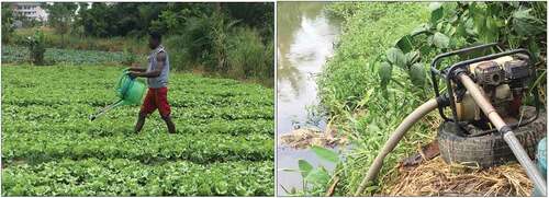
The rudimentary approaches expose the rivers dissolved organic matter and pathogens through microbial activities. For example, the use of organic fertilisers such as poultry manure along the River Wiwi contributes to the microbial count in the river (Amisah and Nuamah Citation2014). Farmers also use chemicals such as pesticides, weedicides, and fertilisers to increase their production. Since their operations are within 100 feet from the water bodies, chemicals applied are likely to seep or be washed into the rivers by runoff water, especially during the rainy seasons, thus reducing water quality. This assertion can be supported by the work of (Raburu and Okeyo-Owuor Citation2002; Okeyo-Owuor et al. Citation2016) which established that agricultural products including fertilisers had a significant impact on water quality with pH and alkalinity as the highest recorded parameters in most water bodies (Ahmed and Dinye Citation2012). Susheela et al. (Citation2014) also established a high concentration of heavy metals ascribed to the pollution load linked with fertilisers use in addition to high hydrocarbon content connected with the use of other chemicals for agricultural production.
It is imperative to note that aside from the negative consequence of agricultural land use to water bodies, the use of water from the rivers for irrigation purposes, as discussed earlier, poses a threat to human health. For example, grey and black water discharged into the River Wiwi by residential and educational facilities are used to irrigate vegetables for human consumption. The Kwame Nkrumah University of Science and Technology, due to the lack of a water treatment plant, discharges its untreated liquid waste into the River Wiwi. Vegetable farmers within the enclave of the university are known to be the leading producers of vegetables in the Greater Kumasi Metropolis who use the contaminated water from the river for irrigation purposes. The practice exposes the farmers, the middle persons, and consumers to sanitation and hygiene-related diseases. Several studies have identified that the vegetables produced with untreated low-quality water in Kumasi contain higher concentrations of microbial pathogens (Obiri-Danso et al. Citation2005; Amisah and Nuamah Citation2014; Amponsah et al. Citation2016) which could be detrimental to human health. In Ghana, statistics suggest that approximately 12,000 Disability-Adjusted Life Years are lost in five major cities, Kumasi included due to the consumption of contaminated vegetables (Seidu et al. Citation2008). Anecdotal evidence also suggests the prevalence of diarrhoea from the consumption of vegetables in the metropolis.
4.1.2. Industrial and commercial land use activities along the rivers
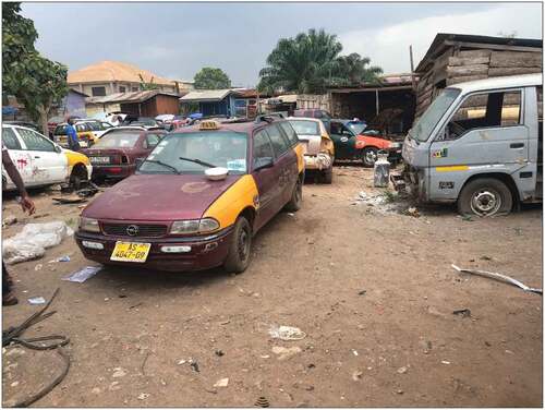
From the study, it was revealed that out of the total land size (743.6 acres) within 100 feet from the two sampled water bodies, industrial and commercial land uses occupied 14.4%. Among the two water bodies, Subin recorded the largest concentration of both commercial and industrial activities (see ). The concentration of these human activities along the river is linked to the fact that it flows through the CBD. Rapid urbanisation in Kumasi, as discussed earlier, has intensified the competition for land especially close to the CBD, as people desire to reduce the cost of commuting from their place of residence to workplaces. Also, the presence of infrastructure and social amenities at the CBD account for the burgeoning. The establishment of businesses within the CDB exposes the urban poor to a larger market opportunity. For example, economic actors such as auto mechanics and welders cannot compete with big businesses for space; they therefore rely on marginal lands such as wetlands for their economic activities (See ). The foregoing explains why the River Subin’s buffer has been infringed the most by industries and commercial activities.
Figure 8. Auto-mechanical shop located within the buffer zone of the River Wiwi.
The increase in commercial activities has also led to a rise in the amount of waste generated in the Metropolis (Miezah et al. Citation2015). The study therefore showed that the growth of human activities within the buffer of the River Subin has exposed the river to both liquid and solid pollution. As already indicated, most of the commercial land uses within the buffer zones of the water bodies are predominantly undertaken by the urban poor (Ahmed and Dinye Citation2012). They often use water bodies as a medium to dispose of their waste because of their inability/difficulty to afford the services of waste collectors. This was evident in the work of Sallah-Phillips (Citation2006) and Ezebilo (Citation2013). In cases where they can afford, the location of the commercial activities becomes inaccessible by waste collection operators. Also, inadequate sanitation facilities and garbage bins in the Asafo market to accommodate the influx of traders on a daily basis have contributed significantly to the pollution of the River Subin (Obiri-Danso et al. Citation2005). The consequences of these impede the free flow of water.
Commercial activities such as washing bay along the water bodies draw several litres of water from them. Residents within the metropolis also draw several litres of water from these rivers for sale and construction. The location of lorry parks and petrol retail stations (8.9%) close to the Subin River also poses a threat of chemical pollution due to likely seepage of petroleum products into the water bodies. The result supports the work of Ahmed and Dinye (Citation2012).
Typical industrial activities along the sampled water bodies include auto-mechanical activities, welding, and wood processing. Along the River Subin, breweries and abattoirs add to the already mentioned industrial activities. This supports the work of Ahmed and Dinye (Citation2012). As highlighted earlier, these industrial activities are owned and managed by the urban poor who live close-knit to their places of work. Due to financial constraints, management of these industrial activities hardly registers their businesses. The situation is a common practice among informal-sector operators in the Kumasi Metropolis (Baah-Ennumh and Adom-Asamoah Citation2012). Since many of these industrial activities are not registered, it becomes difficult for city authorities to regulate their operations. A clear manifestation is their operation within the buffer zones of the water bodies.
Similar to operators of commercial activity, the management of small-scale enterprises use water bodies as a means to dispose of solid and liquid waste. Also, chemical and fuel residue emanating from the activities of auto-mechanics is often washed into water bodies during heavy downpours. Kaasi, a suburb of the Greater Kumasi Metropolis, serves as an industrial hub for breweries and the largest abattoir in Kumasi. These industries serve as an employment avenue for the urban poor. Due to these industrial activities, there has been an insurgence in the population of Kaasi, which has led to an increase in the demand for housing. Thus, resulting in the recent encroachment of the River Subin as the river traverses the community (Ahmed and Dinye Citation2012). The situation has resulted in an increase in the quantity of waste generated along the river, thus, resulting in its pollution. For example, industrial zone with the buffer of water bodies exposes them to considerably high levels of Biochemical Oxygen Demand (BOD), Chemical Oxygen Demand (COD), Total Suspended Solids (TSS), and Total Dissolved Solids (TDS) (Kuhlman et al., Citation2014). A study by Iddrisu (Citation2012) also showed that there is a concentration of industrial activities such as the Guiness Ghana Breweries Ltd at Kaase, the Atonsu Auto mechanical shops, and the Atonsu Sawmill. Even though these industries are not within the buffer of the River Subin, they discharge their waste into the river. This could explain the presence of heavy metals such as Zinc (Zn) and Copper (Cu) among others in the river (Mensah et al. Citation2016). These metals reduce the water quality of the Subin River.
4.1.3. Urban green spaces along the water bodies
The field observations revealed that green spaces occupied 44.2% of the total land use along the two water bodies. Green spaces constituted the highest land use along the Rivers Subin and Wiwi (see ). This could be attributed to the fact that it is expensive to develop wetland; thus, despite weak development control, there are still some green spaces left along the water bodies. This therefore presents an important opportunity for city authorities to preserve the wetlands which have not yet been encroached. Since the River Wiwi flows through peri-urban communities, the growing activities of urban agriculture have led to the decline in greenery to pave the way for farms. The situation explains the 35.4% in greenery as against a 42.5% agricultural land use. From the sampled water bodies, it was observed that the River Wiwi was the only river that flow through nature reserve, the Kwame Nkrumah University of Science and Technology Botanical Gardens.
Nigel and Stolton (Citation2003) argued that well-managed natural forests deliver higher-quality water, with fewer dregs and fewer pollutants generally. Trees play an unbelievable role in decreasing stormwater in diverse ways in addition to removing or purifying pollutants likely to end up in rivers, streams, lakes, and wells (Butler Citation2012). Forests and forestry practices protect, restore, and sustain water quality, water flows, and watershed health and condition (Ekhuemelo et al., Citation2016). Thus, the presence of the Botanical Gardens along the Wiwi River is useful in abating evaporation and aid in its natural purification.
It is imperative, however, to note that the inability of the Subin River to undergo natural purification could be undermined by a concrete drain that engulfs it. It is also worth knowing that in recent times forest reserve and greenery along the water bodies are being destroyed to pave the way for agricultural and infrastructural development due to the rapid urbanisation of Kumasi. Other human activities such as uncontrolled logging and poor farming practices have also destroyed vegetation cover along the water bodies. These human activities manifest because of the lack of strict enforcement of laws, weak institutions, and poor governance (Mishra Citation2011; Ahmed and Dinye Citation2012).
4.2 Water quality analyses of the water bodies
In assessing the water quality of the water bodies studied, the researchers assessed the physical and chemical properties of the Rivers Wiwi and Subin. The water quality was analysed for total dissolved solids, electrical conductivity, salinity, the turbidity of the water bodies, colour, nutrients, carcinogenic and mutagenic toxicities, heavy metals, and the microbiological qualities of the water bodies.
4.2.1 Turbidity of the water bodies
The result of the study showed that turbidity (in NTU) ranged from 0.575 to 10.30 for the Wiwi River and 4.30–16.75 for the Subin River. The water samples collected from the Subin River at the Racecourse area, Bantama, had the highest value (16.75 NTU) and were filled with some black colloids. This can be attributed to the high dissolution of dead organic matters released into the water from the markets that are sited along the river at both banks. Also, suspended matters such as organic and inorganic materials and microorganisms could have contributed to the high turbidity. The mean turbidity values for the Rivers Wiwi (7.84 NTU) and Subin (10.3 NTU) were above the set upper allowable limit of 5 NTU (World Health Organization, Citation2011). This could also be due to the release of untreated waste effluents into the rivers and the presence of suspended matter carried into the river through run-off. The Subin River receives untreated waste from geographical locations such as the Kejetia Mall Complex, the Kumasi Zoological Gardens, the Kumasi Central Market, Adum and Asafo townships. The waste generated from these places may have also contributed to the high turbidity. Siltation arising from the unpaved areas that direct their run-off waters to the rivers could also be another reason for the high turbidity.
4.2.2 Colour
The Subin River runs black from the source, whereas Wiwi runs brownish at all sampled points. The colour of all the samples collected from the water bodies was outside the WHO permissible limit of 5 Hazens (World Health Organization, Citation2011). The colour in surface water bodies studies can be attributed to the leaching of organic materials and is primarily the result of dissolved and colloidal substances present. Overall, the colour of the rivers indicates a health threat to those that use the water (Völker & Kistemann, Citation2011). However, the colour showed no statistically significant differences (p = 0.282) in heavy and light human activity areas across the two rivers.
4.2.3 Nutrients: nitrates and phosphates
The two rivers recorded nitrate concentrations above the WHO limit value of 5.0 mg/L (World Health Organization, 2017). The high levels of nitrate indicate the two rivers are highly polluted. The mean phosphate concentrations were 0.67 ± 0.33, and 0.45 ± 0.11 mg/L, respectively, for the Wiwi and the Subin Rivers. The phosphate levels were relatively high compared to the natural background of 0.02 mg/L (World Health Organization, Citation2011). The study showed that all sample collection points along the two rivers recorded values that were higher than the WHO limit of not greater than 0.3 mg/L (World Health Organization, 2017). The high concentrations may be due to seepages from trash dumpsites, domestic wastewater, and agricultural runoffs deposited into the water bodies, and the application of phosphorus-containing agrochemicals by vegetable farmers along the Wiwi River from Wiwiso through to Gyinyaase. High phosphate concentration is responsible for the eutrophication of a water body as phosphorus is a limiting nutrient for algae growth (World Health Organization, 2017). This would then lead to the proliferation of phytoplankton, and their decomposition over time could lead to high chemical oxygen demand.
4.2.4 Probable carcinogenic and mutagenic toxicities of PAHs in the rivers in Kumasi
Seven carcinogenic PAHs including benzo[a]anthracene, chrysene, benzo[b]fluoranthene, benzo[k]fluoranthene, benzo[a]pyrene, dibenzo[a,h]anthracene, and indeno[1,2,3-c,d]pyrene accounted for a major portion of all the 18 PAHs measured in the sediments of the rivers in Kumasi. The highest level of carcinogenic PAHs in the sediments was recorded in Subin. This suggests industrial effluents are discharged into rivers, and leachates from various approved and illegal (convenient) trash dumpsites contribute hugely to the pollution of the rivers. This also shows a relationship between the intensity of land uses on water quality.
The diagnostic ratios show that the rivers are polluted by PAH compounds of both petrogenic and pyrogenic sources. A point on the Wiwi River recorded 100% petrogenic contaminations, whereas two points on the River Subin recorded 100% pyrogenic PAH contamination. On the Wiwi River, only two points (at the Wiwiso and Gyinyaase sections where there are heavy vehicular activities) showed petrogenic PAHs pollution. The possible human activities that may have contributed to the pollution include the activities of auto-mechanics. However, the frequencies of the sources of PAH pollutants are not consistent with the specific human activities carried out along the rivers, thus, not making them point sources for the pollutions. This indicates the possibility of the contamination of some sites at the rivers being because of atmospheric depositions from non-point sources (Jia et al., Citation2019). Polycyclic aromatic hydrocarbons can travel by air or water from distant sources and can become mobile during runoffs.
4.2.5 Heavy metals
The results of the study further showed that all the sample collection points at Subin and Wiwi Rivers recorded chromium concentrations higher than 100 mg/L and chromium and cobalt concentrations greater than 50 mg/L at all points. The Wiwi River consistently measured more than 60 mg/kg of chromium throughout its course. The average concentration of lead in the Subin River was 46 mg/kg but the concentrations at some water collection points were extremely high. For example, a point close to the Abinkyi Market on the Subin River recorded lead concentrations of 157.73 mg/kg. According to Islam et al. (Citation2018), river sediments could be a major source of Pb contamination. Lead is a ubiquitous pollutant that could find its way into water bodies through the discharge of industrial effluents from various industries such as poultry farms, oil refineries, and textile manufacturers (Islam et al., Citation2018). However, none of such companies was located along the two rivers studied. This implies that other human activities that are not necessarily within the buffer zones could have contributed to this. This implies that sustainable management of water bodies goes beyond controlling the activities within the buffer of the water bodies. Heavy metal concentrations at sites near intense human activities did not differ significantly from those near light human activities.
4.2.5.1 Heavy metal pollution indices
The analysis showed that the two rivers studied were extremely polluted with various metals. The River Subin was the most polluted with heavy metals. Toxic metal concentrations exceeding the background levels are an indication of pollution due to human activities (Li et al., Citation2020). The concentration of the heavy metal found is about tens times more than the background levels (Mikkonen et. al, Citation2018). The Igeo values were 10.26 (Cd), 9.4 (Hg) on the Wiwi River. The Igeo showed that all the points on the Wiwi River were contaminated with Cd, Hg, Co, and Cr. It also indicated that whereas the upstream portions of the River Wiwi are contaminated with the metals, its midstream and downstream are highly contaminated. The Igeo for the Subin River, on the other hand, indicated high to extremely high contamination due to heavy metals (As, Cd, Co, Cr, Hg, and Zn) at the river’s source at the Racecourse. The Igeo indices for the Subin River sediments indicated high to extremely high levels of contamination of heavy metals (As, Cd, Co, Cr, Hg, and Zn) at the river’s source at Racecourse, Bantama, and also at Kumasi Zoological Gardens, and the Abinkyi market.
The concentration factor was also employed to determine the extent of human contributions to these heavy metals (As, Cd, Co, Cr, Hg, and Zn) contaminations in the rivers. Human activities are a major contributor to the levels of pollutions as shown by the concentration factors. The contribution of humans to heavy metal pollutions showed low contamination of Cu and Pb. Pollutions attributed to Cu and Pb were not identified at the Subin’s source. Yet, just about 300 m from the source, the river sediments were moderately contaminated with Pb. The Wiwi and Subin River sediments were extremely polluted with Cd and Hg at all the sections of the river. The main human activity that could connect the heavy metals extremely polluting the rivers in Kumasi is the practice of urban agriculture (Kubier, Hamer, and Pichler, Citation2020). This study cannot link phosphate fertiliser usage to the farming activities carried out along the Wiwi River. The Subin River had no agricultural activities along them, yet they were polluted by the same metals. Elevated concentrations of other trace metals, such as Pb, which can also occur as impurities in phosphate fertilisers were identified as pollutants resulting from human activities.
4.2.7 Microbiological qualities of water from the rivers in Kumasi
The microbiological quality of water from the Wiwi and Subin Rivers was assessed using total coliforms, faecal coliforms, Escherichia coli, and faecal enterococci counts. The results of the analysis showed that the mean of the total coliforms, faecal coliforms, Escherichia coli, and faecal enterococci counts were 1.932 × 10¹⁴, 4.1 × 10⁹, 3.1 × 10⁶, and 79.88 × 10² CFU/100 mL, respectively, all of which surpassed the allowable limits of 400 total coliforms/100 mL and 10 faecal coliforms (E. coli)/100 mL (GEPA, Citation1994). The enormously high counts of the microbial load in the two rivers show they are extremely polluted with faecal matter. The sources of the three rivers defy the odds in the microbial loads. The source of the Wiwi River, for example, had 2.35 × 10¹³ CFU/100 mL for total coliforms, 4.15 × 10¹⁰ CFU/100 mL for faecal coliforms, 2.35 × 10⁸, CFU/100 mL Escherichia coli, and 1.2066 × 10⁴ CFU/100 mL faecal enterococci. However, the counts quickly increased more than 10-folds as the water passed through a nearby settlement area. Human activities along the water body could have contributed to this level of pollution. Domestic effluents are directly allowed into the river, garbage from homes that were dumped at the riverbanks, and the practice of open defaecation. The Wiwi River is mostly used as irrigation water for countless stretches of vegetable farms that are sited along the river from Wiwiso through to Gyinyaase. The Subin River also registered very high counts (2.35 × 10¹⁵ counts/100 mL). The water bodies are under the influence of several human activities such as hospitals, markets, and schools that discharge their wastes directly into them. The rivers in Kumasi under this investigation scored zero passes in quality regarding the EU Guideline Directive of less than 100 faecal coliforms per 100 mL and 100 enterococci per 100 ml of water. The River Wiwi and River Subin are not suitable to be ranked as rivers, but are wastewaters and open urban drains for domestic and non-residential effluents. The water bodies are not suitable for irrigational and recreational purposes. The Escherichia coli concentration in sites with heavy human activities was statistically significantly higher than in sites with light human activities (Mann–Whitney U = 40.5, p = 0.029). Other microbial measures showed no significant differences between heavy and light activity sites: Total Coliforms (p = 0.181), Faecal Coliforms (p = 0.662), and Faecal enterococci (p = 0.228).
4. Conclusion and recommendations
The development of sustainable cities relies on the ability of city authorities to strategically plan for social, environmental, and economic growth of the cities. The concept of sustainable city development clearly shows that urban growth can coexist with natural resources such as water bodies. This can be achieved by ensuring that human activities that are located near water bodies pose minimal threats to their quality and sustenance. The question is ‘is this the situation in Ghanaian Cities?’ This study shows that, within the context of the Kumasi Metropolis, instead of the city urbanising with nature, the city is currently urbanising against nature. This therefore threatens the city’s ability to actualise its potential of being a sustainable city. There is therefore an urgent need for city authorities to put in place measures to save the water bodies in the city. For example, city authorities should put in place measures that will clean the water bodies in the city and convert all buffer areas along the water bodies into beautiful parks and green spaces. Also, incompatible land use activities such as the use of the water bodies as the final disposal site for liquid and solid waste must be stopped as a matter of urgency through the enforcement of the requisite regulations. Additionally, there is the need for a water resource management policy for urban centres. Dedicated institutions should be established for the management of water bodies in our cities. For example, the Thames Policing model in the UK and the River Nile policing model in Egypt can be adopted to save the water bodies in our cities. This is because there is the need for the continuous monitoring of human activities along the water bodies in the city. In order to ensure the enforcement of the zoning regulations along the water bodies, city authorities and policy-makers must invest in emerging technologies such as drones for the monitoring of human activities along the water bodies. Despite the fact that the Zoning Guideline and Planning Standards (2011) provide standard setback average distances for a buffer zone of 50–100 feet from the water bodies, the researchers recommend that the buffer should rather be 100 feet away from the wetland. This is because the wetlands are an important ecosystem service that needs to be protected within the city setting. Ecologically sensitive area that are 100 feet away from wetlands should be acquired and converted into ecologically friendly uses such as urban forestry and greeneries.
Ethical Statement and Informed Consent
The ethical consideration in this study included, but were not limited to, informed and voluntary consent, confidentiality of information, and the anonymity of the respondent. The above-mentioned considerations are in accordance with the Guidelines of the General Research Ethics Board of the Kwame Nkrumah University of Science and Technology.
Disclosure statement
I hereby declare that this submission is my own work and that, to the best of my knowledge and belief, it contains no material previously published or written by another person nor material which to a substantial extent has been accepted for the award of any other degree.
Additional information
Funding
Notes on contributors
Stephen Appiah Takyi
Dr. Stephen Appiah Takyi completed his Doctoral education at the School of Natural Re-sources and Environmental Studies, University of Northern British Columbia. Dr. Takyi holds a Bachelor of Science degree in Planning specializing in Development Policy from the Kwame Nkrumah University of Science and Technology, Kumasi, Ghana. He also holds a Master’s degree in Urban and Regional Planning from Queen’s University, Kingston, Ontario. His re-search and professional experiences have been in the areas of policy analyses, development planning, urban and environmental sustainability. Owusu Amponsah, Ph.D. Kwame Nkrumah University of Science and Technology, Ghana Email Address: [email protected]
Owusu Amponsah
Dr. Owusu Amponsah holds a PhD in Planning with emphasis on policy analysis, a Master of Science degree in Development Policy and Planning, Postgraduate diploma in Land Manage-ment and Informal Settlements Regularization and Bachelor of Science degree in Planning. His research and professional experiences have been in the areas of policy analyses, urban pov-erty reduction, and informal settlements regularisation. Godfred Darko Department of Chemistry, Kwame Nkrumah University of Science and Technology, Ghana Email Address: [email protected]
Godfred Darko
Godfred Darko is an environmental analytical chemist with research interests in sample preparation, bioaccessibility of metals and xenobiotic substances, environmental monitoring, water purification, contamination assessment and remediation. He has supervised several research on environmental monitoring and remediation of contaminated sites in Africa. Darko is an Editor for Heliyon (Elsevier multidiscipline open access journal) and Environmental Monitoring and Assessment (Springer). Charles Peprah Department of Planning, Kwame Nkrumah University of Science and Technology, Ghana Email Address: [email protected]
Charles Peprah
Professor Charles Peprah is an Associate Professor at the Department of Planning. He has been actively engaged in research activities to enrich his teaching. Charles Peprah has published his research findings in high impact journals (such as the Transport and Health, Cities, Sustainable Cities and Society, GeoJournal, Outdoor Recreation and Tourism, Environmental Development etc.) in his areas of specialty. Richard Apatewen Azerigyik Department of Planning, Kwame Nkrumah University of Science and Technology, Ghana Email Address [email protected]
Richard Apatewen Azerigyik
Mr. Richard Azerighik holds a Bachelor of Science degree in Development Planning from the Kwame Nkrumah University of Science and Technology, Ghana. He also obtained his Master of Philosophy in Planning from the same university. He is interested in informal settlements, development planning and urban sustainability. Gabriel Kofi Mawuko Department of Planning, Kwame Nkrumah University of Science and Technology, Ghana [email protected]
Gabriel Kofi Mawuko
Mr. Gabriel Mawuko holds a Bachelor of Science degree in Human Settlement Planning from the Kwame Nkrumah University of Science and Technology, Ghana. He is interested in spatial analysis, development planning and land use planning. Augustine Chiga Awolorinke Kwame Nkrumah University of Science and Technology, Ghana Email Address: [email protected]
Augustine Awolorinke Chiga
Mr. Augustine Awolorinke holds a Bachelor of Science degree in Development Planning from the Kwame Nkrumah University of Science and Technology, Ghana. He is interested in devel-opment planning, environmental sustainability and social policy analysis.
References
- Ahmed A, Dinye RD. 2012. Impact of land use activities on Subin and Aboabo rivers in Kumasi Metropolis. Int. J. Water Res. Environ. Eng 4(7):241–251. doi:10.5897/IJWREE12.036.
- Amisah S, Nuamah PA. 2014. Spatial and temporal variations in microbiological water quality of the river Wiwi in Kumasi, Ghana. Water Qual Expo Health. 6(4):217–224. doi:10.1007/s12403-014-0128-4.
- Amoateng P, Finlayson CM, Howard J, Wilson B. 2018(January 2017). Dwindling rivers and floodplains in Kumasi, Ghana: a socio-spatial analysis of the extent and trend. Appl Geogr. 90:82–95. doi:10.1016/j.apgeog.2017.11.007
- Amponsah O, Vigre H, Braimah I, Schou TW, Abaidoo RC. 2016. The policy implications of urban open space commercial vegetable farmers’ willingness and ability to pay for reclaimed water for irrigation in Kumasi, Ghana. Heliyon. 2(3):e00078. doi:10.1016/j.heliyon.2016.e00078.
- Asare-Donkor NK, Wemegah DD, Adimado AA 2013. Chemical Analysis of Freshwater Bodies in the Kumasi Metropolis and Its Environs, Ghana. Chemical Analysis. 3(9):1–10.
- Attua EM, Ayamga J, Pabi O. 2014. Relating land use and land cover to surface water quality in the Densu River basin, Ghana. Nt. J. River Basin Manag 12(1):57–68. doi:10.1080/15715124.2014.880711.
- Ayambire RA, Amponsah O, Peprah C, Takyi SA. 2019 February. A review of practices for sustaining urban and peri-urban agriculture: implications for land use planning in rapidly urbanising Ghanaian cities. Land Use Policy. 84:260–277. DOI:10.1016/j.landusepol.2019.03.004.
- Azerigyik RA, Amponsah O, Takyi SA. 2018. Clarifying the debate on the nexus between slum upgrading and the economic well-being of beneficiaries with insight from Ashaiman, Ghana. J Archit Plann Res. 35(3):194–217.
- Baah-Ennumh TY, Adom-Asamoah G. 2012. The role of market women in the informal urban economy in Kumasi. Indian J Sci Technol 32(2):56–67.
- Brandful P, Issahaku P, Boadi J, Mensah R, Marshall A. 2021 March. Contested urban spaces in unplanned urbanization : wetlands under siege. Cities. 103489. doi: 10.1016/j.cities.2021.103489
- Butler R 2012. Climatic Role of Forests in https://rainforests.mongabay.com/0906.htm Retrieved January 15,
- Cobbinah PB, Erdiaw-Kwasie MO. 2018. Urbanization in Ghana. Int. J. E-Plan. Res. 256–278. doi:10.4018/978-1-5225-5646-6.ch012
- Cobbinah PB, Niminga-Beka R. 2017. Urbanisation in Ghana: residential land use under siege in Kumasi central. Cities. 60:388–401. doi:10.1016/j.cities.2016.10.011
- Cobbinah PB, Nyame V. 2021. A city on the edge: the political ecology of urban green space. Environ Urban. 5. doi:10.1177/09562478211019836
- Coffie J. 2014. Assessment of physicochemical properties and heavy metals in water, sediment and fish (Oreochromis niloticus) from the upper volta basin (Stratum VII), Ghana. Kumasi, Ghana: [Kwame Nkrumah University of Science and Technology (KNUST)]. doi:10.1038/132817a0
- Danquah L, Abass K, Nikoi AA 2011. Anthropogenic pollution of inland waters: The case of the Aboabo River in Kumasi, Ghana. Journal of Sustainable Development. 4(6):103–115. doi:10.5539/jsd.v4n6p103.
- Darko G, Obiri-Yeboah S, Takyi SA, Amponsah O, Borquaye LS, Amponsah LO, Fosu-Mensah BY. 2022. Urbanizing with or without nature: pollution effects of human activities on water quality of major rivers that drain the Kumasi Metropolis of Ghana. Environ Monit Assess. 194(1):1–18. doi:10.1007/s10661-021-09686-8.
- Eduful M, Shively D. 2015. Perceptions of urban land use and degradation of water bodies in Kumasi, Ghana. Habitat Int. 50:206–213. doi:10.1016/j.habitatint.2015.08.034
- Ekhuemelo, D. O., Amonum, J. I., & Usman, I. A. 2016. Importance of forest and trees in sustaining water supply and rainfall. Nigeria Journal of Education, Health and Technology Research (NJEHETR). 8(1):273–280.
- Ezebilo EE. 2013. Willingness to pay for improved residential waste management in a developing country. Int J Environ Sci Technol. 10(3):413–422. doi:10.1007/s13762-012-0171-2.
- Filho WL. 2015. Sustainable Water Use and Management. eds. Filho WL, Sümer V. Midtown Manhattan, New York City: Springer International Publishing: doi: 10.1007/978-3-319-12394-3
- GEPA 1994. The effluent guidelines for discharges into natural waters. Ghana Environmental Protection Agency Act 490. Accra, Ghana. Accra: Ghana Environmental Protection Agency.
- Ghana Statistical Service. (2013). 2010 population and housing report. Regional analytical report: ashanti region.
- Ghana Statistical Service. (2014). Urbanisation in Ghana: 2010 Population & Housing Census Report.
- Ghana Statistical Service (GSS). Population & housing census national analytical report. Ghana Statistical Service. (2013). 2010.
- Haddis A, Getahun T, Mengistie E, Jemal A, Smets I, van der Bruggen B. 2014. Challenges to surface water quality in mid-sized African cities: conclusions from Awetu-Kito rivers in Jimma, south-west Ethiopia. Water Environ. J 28(2):173–182. doi:10.1111/wej.12021.
- Iddrisu A-R. 2012. Assessing the ecology of wetlands in Kumasi and the adaptations of the communities to floods. Kumasi College: Kwame Nkrumah University of Science and Technology.
- Islam, M. S., Hossain, M. B., Matin, A., & Sarker, M. S. I. (2018). Assessment of heavy metal pollution, distribution and source apportionment in the sediment from Feni River estuary, Bangladesh. Chemosphere, 202, 25–32.
- Jia Q, Chen X, Köllner TG, Rinkel J, Fu J, Labbé J, Chen F 2019. Terpene synthase genes originated from bacteria through horizontal gene transfer contribute to terpenoid diversity in fungi. Sci Rep. 9(1):1–11.
- Khatri N, Tyagi S. 2015. Influences of natural and anthropogenic factors on surface and groundwater quality in rural and urban areas. Frontiers in Life Science. 8(1):23–39. doi:10.1080/21553769.2014.933716.
- Korah PI, Cobbinah PB, Nunbogu AM, Gyogluu S. 2017. Spatial plans and urban development trajectory in Kumasi, Ghana. GeoJournal. 82(6):1113–1134. doi:10.1007/s10708-016-9731-1.
- Koranteng A, Adu-Poku I, Donkor E, Zawiła-Niedźwiecki T. 2020. Geospatial assessment of land use and land cover dynamics in the mid-zone of Ghana. Folia For. Pol. A. 62(4):288–305. doi:10.2478/ffp-2020-0028.
- Kubier A, Hamer K, Pichler T 2020. Cadmium background levels in groundwater in an area dominated by agriculture. Integr Environ Assess Manag. 16(1):103–113.
- Kuhlmann ML, Imbimbo HRV, Ogura LL, Villani JP, Starzynski R, Robim MDJ. 2014. Effects of human activities on rivers located in protected areas of the Atlantic Forest. Acta Limnologica Brasiliensia. 26:60–72. doi:10.1590/S2179-975X2014000100008.
- Li Q, Liu J, Gadd GM 2020. Fungal bioremediation of soil co-contaminated with petroleum hydrocarbons and toxic metals. Appl Microbiol Biotechnol. 104(21):8999–9008.
- Melakua S, Wondimub T, Damsa R, Moens L. 2007. Pollution status of Tinishu Akaki river and its tributaries (Ethiopia) evaluated using physico-chemical parameters, major Ions, and nutrients. Bull Chem Soc Ethiop. 21(1):13–22.
- Mensah MB, Boadi NO, Baa-Poku F, Wemegah DD, Badu M, Saah SA, Osei-Dei B. 2016. Physicochemical properties and levels of heavy metals in selected rivers within the Kumasi Metropolis of Ghana. Int. J. Sci. Technol. Manag 5(12):616–623.
- Miezah K, Obiri-Danso K, Kádár Z, Fei-Baffoe B, Mensah MY. 2015 September. Municipal solid waste characterization and quantification as a measure towards effective waste management in Ghana. J. Waste Manag 46:15–27. DOI:10.1016/j.wasman.2015.09.009.
- Mikkonen HG, Dasika R, Drake JA, Wallis CJ, Clarke BO, Reichman SM 2018. Evaluation of environmental and anthropogenic influences on ambient background metal and metalloid concentrations in soil. Sci Total Environ. 624:599–610.
- Ministry of Water Resource Works and Housing. 2007. National water policy. Accra, Ghana.
- Ministry of Water Resources Works and Housing. 2011. RIPARIAN BUFFER ZONE POLICY For Managing Freshwater Bodies in Ghana. November. 35.
- Mishra SK (2011). An investigation into globalization and Uneven Urbanization in Africa. Sixth African Population Conference, Ouagadougou, Burkina Faso. 1–13.
- Monney I, Boakye R, Buamah R, Anyemedu FOK, Odai SN, Awuah E 2013. Urbanization and pollution of surface water resources in the two largest cities in Ghana. International Journal of Environmental Monitoring and Analysis. 1(6):279. doi:10.11648/j.ijema.20130106.12.
- Narh SN, Takyi SA, Asibey MO, Amponsah O. 2020 August. Garden city without parks: an assessment of the availability and conditions of parks in Kumasi. Urban For. Urban Green 55:126819. DOI:10.1016/j.ufug.2020.126819.
- Nigel D, Stolton S. 2003. The Ethnomusicologists’ cookbook, volume II. Washington, DC: World Bank/WWF Alliance for Forest Conservation and Sustainable Use. doi:10.4324/9780203780930
- Nkonya E, Cenacchi N, Ringler C, Lantieri D. 2012. International cooperation for sustainable land and water management.
- Obiri-Danso K, Weobong CAA, Jones K. 2005. Aspects of health-related microbiology of the Subin, an urban river in Kumasi, Ghana. J Water Health. 3(1):69–76. doi:10.2166/wh.2005.0007.
- Okeyo-Owuor JB, Raburu PO, Masese FO, Omari SN. 2016. Wetlands of lake Victoria basin, Kenya: distribution, current status and conservation challenges. In: Community Based Approach to the management of Nyando Wetland. Kenya Disaster Concern: VIRED, UNDP; p1–4.
- Okumah M, Yeboah AS, Amponsah O. 2020. Stakeholders’ willingness and motivations to support sustainable water resources management: insights from a Ghanaian study. Conserv. sci. pract 2(3):1–14. doi:10.1111/csp2.170.
- Okumah M, Yeboah AS, Nkiaka E, Azerigyik RA. 2019. What determines behaviours towards water resources management in a rural context? Results of a quantitative study. Resources. 8(2):109. doi:10.3390/resources8020109.
- Owusu-Ansah ED-GJ, Sampson A, Amponsah SK, Abaidoo RC, Hald T. 2015. Performance, compliance and reliability of waste stabilization pond: effluent discharge quality and environmental protection agency standards in Ghana. Res. J. Appl. Sci. Eng. Technol 10(11):1293–1302. doi:10.19026/rjaset.10.1825.
- Petruzzello M. 2020. Water scarcity. Chigaco, Illinois: Water Resource; Encyclopædia Britannica.
- Raburu PO, Okeyo-Owuor JB. 2002. Impact of agro-industrial activities on the water quality of river Nyando, Lake. 307–314.
- Rahayu P, Mardiansjah FH (2018). Characteristics of peri-urbanization of a secondary city: a challenge in recent urban development. IOP Conference Series: Earth and Environmental Science, Banda Aceh, 126, 012164. 10.1088/1755-1315/126/1/012164
- Rop RK. 2014. Impact of anthropogenic activities on bacteriological water. Njoro, Kenya: Egerton University.
- Sallah-Phillips A. 2006. The institutional & legal framework for protecting poor communities’ access to water supply and sanitation in the Senegal and Volta river basins. Cranfield, Wharley: Cranfield University.
- Sammy CKT, Gideon KD, Stephen YG. 2013. River Wiwi: a source of Schistosoma haematobium infection in school children in Kumasi, an urban African setting. Afr. J. Microbiol. Res 7(20):2213–2220. doi:10.5897/ajmr12.489.
- Santhanam H, Majumdar R. 2022. Quantification of green-blue ratios, impervious surface area and pace of urbanisation for sustainable management of urban lake–land zones in India-a case study from Bengaluru city. J. Urban Manag 11(3):310–320. doi:10.1016/j.jum.2022.03.001.
- Seidu R, Heistad A, Amoah P, Drechsel P, Jenssen PD, Stenström T-A. 2008. Quantification of the health risk associated with wastewater reuse in Accra, Ghana: a contribution toward local guidelines. J Water Health. 6(4):461–471. doi:10.2166/wh.2008.118.
- Songsore J (2009). The Urban transition in Ghana: Urbanization, National Development and Poverty Reduction.
- Susheela S, Srikantaswamy S, Kumar DS, Gowda A, Jagadish K. 2014. Study of Cauvery river water pollution and its impact on socio-economic status around KRS Dam, Karnataka, India. Environ. Earth Sci Geotech. Eng. 4(2):91–109.
- Takyi SA, Amponsah O, Yeboah AS, Mantey E. 2020. Locational analysis of slums and the effects of slum dweller’s activities on the social, economic and ecological facets of the city: insights from Kumasi in Ghana. GeoJournal. 2. doi:10.1007/s10708-020-10196-2
- The reference should read “BlackMicrobiology: principles and explorations, J. G.(2008). Microbiology: principles and explorations. John Wiley & Sons, Hoboken, New Jersey, 14–17.
- Tobergte DR, Curtis S, Repasky M, Beuming T. 2013. The study on the comprehensive urban development plan for greater Kumasi in the republic of Ghana. J Chem Inf Model. 53(9):1689–1699. doi:10.1017/CBO9781107415324.004.
- Tutu RA, Stoler J. 2016. Urban but off the grid: the struggle for water in two urban slums in greater Accra, Ghana. Afr. Geogr. Rev. 35(3):212–226. doi:10.1080/19376812.2016.1168309.
- UN-Habitat. 2012. State of the world’s cities 2010/2011: cities for all, bridging the urban divide. Nairobi, Kenya: Earthscan Publication Ltd.
- UN-WWAP. (2015). The United Nations world water development report 2015: water for a sustainable world. UNESCO Publishing.
- UNESCO, & UN-WWAP. (2020). The United Nations world water development report 2020: water and climate change. UNESCO Publishing.
- United Nations. 2019. World Urbanization Prospects: the 2018 Revision. In: Demographic research. New York: Revised). United Nations; p. 1–65.10.4054/DemRes.2005.12.9
- Völker S, Kistemann T 2011. The impact of blue space on human health and well-being–salutogenetic health effects of inland surface waters: A review. Int J Hyg Environ Health. 214(6):449–460.
- WHO. 2006. Guidelines for the safe use of wastewater, excreta and greywater. In: 7th World Health Organization. Geneva: World Health Organization; Vol. 1, p. 1-182.10.1080/01422419908228843
- World Health Organization. 2011. Guidelines for drinking-water quality. Geneva.
- Zhang XQ. 2016. The trends, promises and challenges of urbanisation in the world. Habitat Int. 54(13):241–252. doi:10.1016/j.habitatint.2015.11.018.