Abstract
There is a confluence between GIS and space syntax, which is based on the theory of topology and well known in the research field of Computer-Aided Architectural Design (CAAD). Although many GIS software have been employed to develop analytical tools in accordance with the theory of space syntax, there is still a need to explore its mathematical foundation for better understanding and interpretation of the results produced by the programs. This research attempts to provide more profound mathematical definitions about some basic concepts of space syntax. Furthermore, we will delve into the mathematical definition to discover some embedded characteristics that have not yet been mentioned by space researchers. Some conjectures are also proposed and tested using two traditional Taiwanese settlements. The concept of saturation, suggested by this research, is a new possibility to identify the centrality, peripheral regions, private place, key gateways, and subregions in settlements. This study also shows that this quantitative approach can well supplement the qualitative approach used by most researches nowadays.
1. Introduction
Geographical Information Systems (GIS) deal with surveying, recording, storing, analyzing, and representing geographical space. GIS have been applied to many fields, from exploration and conservation of natural resources in early days to social science in these years. Urban and regional management is a prominent field of application for GIS. Besides establishing essential data bases, spatioanalytical functions such as overlaying, buffering, visualization, triangulation, Voronoii Diagram, shortest paths, and so on, are commonly used to explore the structure of urban and regional space.
However, GIS is not the only way to study man made space. As a matter of fact, architectural researchers have been studying space structures of buildings, communities, and cities for a long time using Computer-Aided Architecture Drawing/Design (CAAD).
The various approaches for analyzing built-up spaces in CAAD can be classified as follows: linguistics, fractal theory geometry, symbolic logic, and topological. Linguistics employ shape grammar to generate buildings (Stiny Citation1978). Fractal theory geometry discloses unchanged properties of spatial structures in different scales (Bovill Citation1996). Symbolic logic uses the propositional logic or first-order logic to describe the spatial structure and perform spatial reasoning accordingly (Mitchell Citation1989).
Topology, which is of particularly interest to this study, regards space as a relation among different nodes and connections. Topology is an essential concept both in GIS and in CAAD. Without generating the topological structure among geographical objects, GIS cannot have various capabilities for spatial analyses. On the contrary, architects usually use spatial bubble diagram in the stage of conceptual design to express their floor plans where rooms are denoted as bubble nodes (Do and Gross Citation2001). Mitchell (Citation1977) and Steadman (Citation1983) further formally applied the theory of topology to describe, manipulate, and generate building plans. Moreover, topology can not only be used to describe the physical spaces but also depict the social activities within the buildings, communities, and cities. The researchers of CAAD are trying to find rational methods for spatial designs and analyses by converting intangible thoughts into explicit representations and procedures.
Architectural researchers are interested in not only individual buildings but also communities, settlements, and cities. Many researchers attempt to explore significances and cultural meanings of these man-made environments. However, they mainly use literal language to describe complicated, abstract, deep, and obscure spatial structures and cultural meanings. Therefore, social and cultural structures are seldom able to be sufficiently represented in a functional way. Of late, the computational approach for discussing architectural spaces has been stressed, and it has opened a new research area (Simon Citation1969).
Under the influence of Simon (Citation1969), a pioneer in artificial intelligence, the Carnegie Mellon University first applied artificial intelligence and cognitive science to CAAD research. Some precursors of CAAD research, such as Chuck Eastman (Citation1989), Tom Maver (Citation1988), John Gero (Citation1990), Ulrich Flemming (Citation1987), Omer Akin (Citation1986), William Mitchell (Citation1977), and Tsuyoshi Sasada (Citation1980) have introduced databases, computer graphics, work study, linguistics, cognitive science, and social behavior, into CAAD research.
Among them, Hillier and Hanson (Citation1984) coined the term space syntax in their book, The Social Logic of Space, as a new method to discuss the relationships between physical city forms and their activities. The development of space syntax is blooming. A dedicated website (http://www.spacesyntax.org/) has been established. Six international symposiums of thave been held on the domain of ‘Space Syntax’ and the applications to various fields such as neighborhood study, urban morphology, comparative urban analysis, transportation, pedestrian movement, way finding, crime, preservation, rehabilitation, visibility, spatial cognition, land use, land value, demographics, environment management. Furthermore, some GIS software, such as MapInfo, ArcGIS, GRASS, were also employed to develop analysis tools based on the theory of space syntax. This marked the confluence of GIS and CAAD (Abubakar and Aina Citation2006, Space Syntax Limited Citation2007, Wang and Liao Citation2007, Griffiths et al. Citation2008).
Although the theory of space syntax is based on topology, surprisingly, there is no clear program documentation and mathematical definition (Jiang and Claramunt Citation2002). Time and again, this causes confusion in the interpretation of the results of the analysis module(s). Thus, it is worthy to revisit the theory of topology, which is the theoretical foundation of space syntax, to better understand the results. Moreover, by revisiting the origin of space syntax in the theory of topology, this article finds an innovative approach to exploit public and private places, and central and peripheral areas in settlements.
The remainder of this article is organized as follows. Section 2 briefly reviews the essence of space syntax. Section 3 defines basic terms and explores their mathematical properties. Section 4 further rethinks the meaning of centrality. Section 5 uses two traditional Taiwanese settlements as cases to test the conjectures proposed in Section 4. Section 6 discusses the results from Section 5. Finally, Section 7 provides the conclusion and suggests some future work.
2. Space syntax
Space syntax is based on the theory of topology, which is a study of nodes and links among them. Nodes belong to one of the three kinds of basic spaces: (1) convex space where any two points are mutual visible; (2) an axial space, which is composed of straight lines, such as roads; (3) isovist space, which is a space constructed by the range with respect to viewsheds. Meanwhile, the links among various basic space nodes could be physically connected or intervisible.
Based on this spatial configuration, space syntax performs analyses in terms of two concepts, namely, relative depth and path selection. The relative depth of a node refers to its relative position within a space system; whereas the path selection represents all possible paths between any two elements in a space system. Usually, more than one path is possible between two nodes; however, the length of the shortest path is unique. The step number of the shortest path in-between corresponds to the concept of depth in the theory of space syntax, and it can be used to compare different settlements quantitatively (Su Citation1999).
The concept of relative depth, together with control value and connectivity, is further applied to calculate global and local integration values for analyzing physical space and socioculture structure of settlements. In this way, the relationship between the physical space and the sociocultural structure can be quantitatively measured (Lin Citation2001). Most subsequent space syntax researches, such as Bustard (Citation1999), Asami et al. (Citation2002), Yang (2004), Kigawa et al. (Citation2006), Wang (Citation2006), Hillier et al. (Citation2007), and Yu et al. (Citation2009) are based on the aforesaid measurements.
Although many researchers use the axial map, where only roads are considered and represented as nodes, to extract the space structure, Jiang and Claramunt (Citation2002) pointed out that the process of identifying the spatial elements of axial lines is subjective, noncomputable, nondeterministic, and partially empirical. Also, the spatial analysis of the visibility and the permeability of the Space Syntax are based on the map, but a map is a simplified representation of the real world and cannot record true activities comprehensively.
We further found that the current theory of space syntax has limitations when dealing with the phenomena of life styles, spatial activities, and cognition in the case studies of Taiwan's settlements. Although an axial map in space syntax decomposes roads as a series of the longest straight sight lines, it assumes the homogeneity of the activity in a linear space unit and implies that only visual experience is considered to realize spatial structure of the settlement. But, in the real world, visual experience is only one of the multifacets of social activities and relationships, and various kinds of activities may occur along a straight street. Thus, visibility and permeability analyses based on homogeneously linear space are unable to capture the diversity of social activities in space. Subsequently, a new approach to code attitude and perception of settlement residents is needed.
There are many extensions beyond simple axial configuration. For examples, Yang (Citation2007) and Hillier et al (Citation2007) consider factors of geometry, distance, and weight functions. However, this research does not intend to do so. The consideration is similar to the case of Bubble Diagram in conceptual design phase, which is a typical example of application of topology on architectural design. Bubble Diagram analyzes spatial relations among potential activities and helps designers to find solutions for design problems. Although Bubble Diagram is conducted as part of the conceptual design phase, factors of direction, distance, and size are considered during the physical design phase. Similarly, the research focuses on studying the abstract structure of social spaces without involving factors of geometry, distance, and weight functions.
3. Depth and saturation
Before dealing with intricate issues concerning the relationship of physical and social structures, it is worthy to rethink the exact meaning of depth in the theory of space syntax by reconstructing its mathematical expression from the basic terms. As a matter of fact, we further develop a new concept, called saturation, based on the definition of stepwise depth.
3.1. Definitions of terms
The terms used in the study are defined as follows:
Graph and tree structures: A graph is mathematically composed of nodes and links, where each link is always connecting two different nodes. A tree is a kind of a graph without loops. Please note that the spatial structures of settlements are normally represented as graphs, where these exist many interconnections and transitive relations. However, they can be simplified into minimum spanning trees (Sahni Citation1981), where all the nodes are kept and interconnected but some links are deleted for not forming any loop.
Root node: Every node in a graph can be regarded as a root node. Thus, a particular minimum spanning tree can be constructed with respect to it.
Layer: the root node is labeled as in layer 0, and every unlabeled node connected to a node in layer i is labeled as in layer i + 1.
Stepwise Depth [the total minimum travelling distance of nodes within s layers (steps) with respect to node j]: Let node j be the root with k layers, and there are ni
nodes at layer i (≦k), the number of nodes within s (≦k) layers with respect to node j is
. Please note that the concept of
is realized as ‘depth’ by Hillier and Hanson (Citation1984) from the viewpoint of urban space analysts, and movements across layers are regards as steps. Thus, one-step depth (D1), two-step depth (D2), three-step depth (D3), and total depth mentioned in space syntax are, respectively, corresponding to
, and
.
Saturation: For a node, the depth value may increase when step increases. A node is saturated when all the other nodes are visited and its maximum depth value is reached.
3.2. Mathematical properties of depth
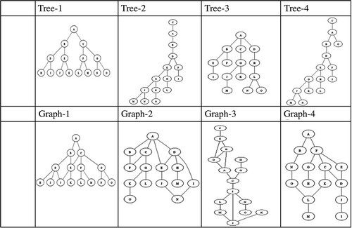
To correctly interpret the results of spatial and social analyses, it is necessary to reveal its numerical characteristics embedded in the calculations of . Because tree and graph are two common data structures, which can be used to describe physical spaces and social activities, this section takes four tree structures and four graph structures, each with 15 nodes, shown in , as illustrative examples. Among these eight structures, tree-1 is intentionally designed as a balanced binary tree in terms of node A, tree-2 is a leftist tree, whereas others are generated at random. It should also be noted that, only with respect to node A, tree-1 can be a balanced binary tree, where the difference of the number of layers in the left and right subtrees is less than 1. Tree-1 will be no longer a balanced binary tree with respect to other nodes.
Figure 1. Illustrative topologic structures.
The depths of the eight structures are calculated by taking each node in turn as the root. The stepwise depth values of each root node are computed. That is, in our illustrative cases, one-step depth (D1), two-step depth (D2), three-step depth (D3), …, 15-step depth (D15) are calculated. shows the increasing trends of depth values for each node as a root node in the eight structures. Recall that a node is saturated at step s if after that the depth value is no longer increased; in other words, the corresponding trend line becomes flat.
Figure 2. The trends of depth values.
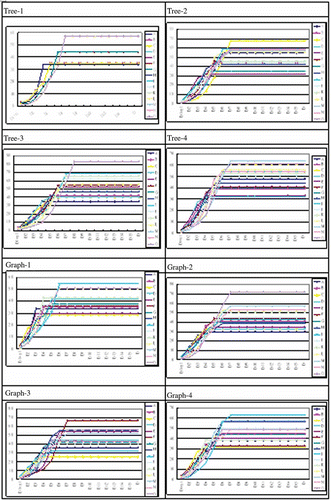
Based on the result (), we found that the higher the depth values of nodes in the beginning steps, the quicker they will be saturated and the lower their final values. In the eight exploratory structures, the nodes with the lowest depth values in the beginning tend to be finally saturated and have the highest final values. Furthermore, we find that these properties are closely related to the ideas of centrality and peripherality, which will be discussed and tested by two settlements below. However, a mathematical proof of the intuitive tendency needs to be worked out in the future.
4. Centrality
It may be recalled that the main interest of space syntax is to try and explore the relationship between physical and social structures of settlements. Among many subjects, the issue of centrality has attracted significant interest. Hillier (Citation1998) used an axial map, deriving from road map, to analyze London. He discovered that Oxford Street had the smallest integration value and happened to be the main shopping street and the busiest area in Europe. Akkelies van Nes (Citation2007) analyzed the relationships between integration value and human movement of some cities in the Rijnland region. He discovered that higher the integration value, the easier to gather the crowd. Those areas were mostly regional centers.
This research is not limited to the road system only. Buildings, courtyards, shrines, bus stops, temporary markets, and so on, are also denoted as nodes. Physically adjacent space nodes are associated by links. Employing the concept of saturation mentioned in the previous section, we found that there is another approach to define centrality in topographical structures. identifies the nodes that are early and later saturated, and with the highest and lowest depth values for every exploratory structures in . It is noted that we temporarily choose 20% as the threshold to group the first and latest saturated nodes to explore some interesting properties discussed below. It is most likely that the threshold value will vary because of graph size and affect the properties. However, we leave the discussion of appropriate threshold value in the future work. According to our suggested threshold value, indicates the positions of these interested nodes in the structures. Based on these results, we have the following conjectures that will be tested in the following sections.
Figure 3. Topological positions of center, early, and later saturated nodes.
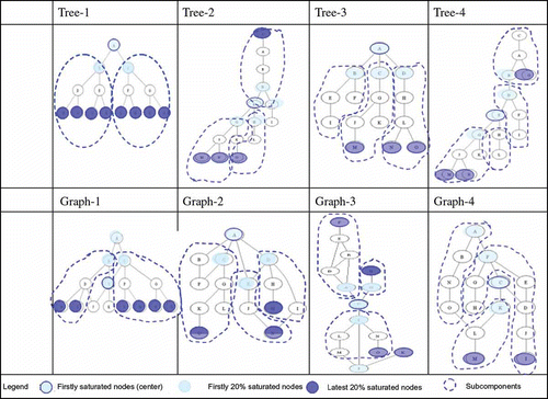
Table 1. Early and large saturated nodes
(1) Centrality can be derived from saturation.
and together show that the nodes being firstly saturated can be regards as the centers of tree and graph structures. The earliest saturation means that the corresponding node can reach the whole space with the least steps. It coincides with the concepts of center.
(2) The first 20% saturated nodes are keys of partitions.
As shown in , these nodes marked by the first 20% saturated nodes can be used to partition trees/graphs into several subregions, which are circled by dotted lines. Being adjacent to the central regions, they can be regarded as gateways through which subregions are able to access to the central regions. It is noted that there are some nodes not belonging to any sub-region.
(3) Inaccessibility can be indicated by the later saturated nodes.
The later 20% saturated nodes are in the peripheral regions. In particular, the nodes with the highest values are the external nodes of the structures. In other words, they are the nodes which are most difficult to be reached in the whole space.
(4) Notions are compatible to each other with a mapping between theories.
Lynch (Citation1960) identified nodes, edges, paths, districts, and landmarks as five elements of city image. It is interesting to see if the concepts of centrality, edge and regions have corresponding notions in the theories of space syntax and city image. Because paths are regarded as nodes in space syntax and this research does not distinguish landmarks from nodes, it is obvious that a mapping between theories is needed.
5. Case study on traditional settlements in Taiwan
This study tests the above conjectures using two traditional Taiwanese settlements as case studies: Dajia in Taichung and Fanglan in Taipei. Although many researches on traditional Taiwanese settlements have been done to explore their fruitful cultural and social contents, they are mostly qualitative. Thus, these two study cases are not only for testing the conjectures but also for exploring the possibility of supplementing traditional researches using quantitative computation upon topological representation.
5.1. Settlement case study
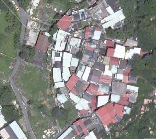
There are two cases. Case 1 is a township, located about 150 km south to Taichung City, and is a settlement of consanguinity (). It has been developed from the 1660s to the present. Case 2 is a settlement () at the foot of Fanglan Hill in the suburb of Taipei. Its development started in 1806 and it presently consists of different social groups.
Figure 4. Satellite photo of Dajia settlement.
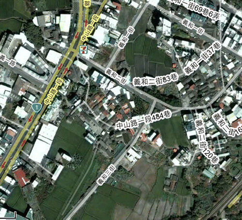
Figure 5. Satellite photo of Fanglan settlement.
5.2. Spatial topology
A spatial topology structure is composed of ‘nodes’ (spatial elements) and ‘links’ (spatial relations). This section will discuss structural relationships between nodes and links. Although Hillier and Hanson (Citation1984) proposed some basic principles to identify spatial topology structures, this study found that their principles are hard to apply to the two settlements. The identification of spatial elements and spatial relations is not clear. Different research viewpoints and methods may have different identifications of spaces. Thus, a more lucid principle is needed to avoid arbitrary construction of spatial topology structure.
This study does not define the spaces by making axial maps and convex spaces as in conventional space syntax researches. We conduct visual inspection and observation into these two case settlements first. After obtaining a rough understanding of settlements, we mark spatial elements (nodes) and spatial relations (links) in topological maps according to field inspections and definitions of spaces to form spatial topologies for these two cases. A topological structure is formed, and its space configuration can be clearly expressed (Lee and Lin Citation2007).
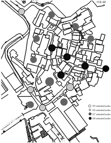
As mentioned above, a spatial topology is consisted of nodes and links. All spaces (including open space and physical spaces) are nodes, and the nodes are indicated by capital letters, namely A, B, C, D, E, …, to represent open spaces, including squares, front courtyards, passageways, ladders. The Arabic numbers, namely, 1, 2, 3, 4, 5, …, represent physical spaces, including houses, temples, dormitories. and mark these nodes and subregions on the maps, respectively. and represent them in graph structures, where the solid lines represent the attainable relation among nodes of open and physical spaces. This study calculates all nodes in the space, but only public spaces are discussed here. The stepwise depth values of every node are calculated and shown in , respectively.
Figure 6. Nodes of Dajia settlement.
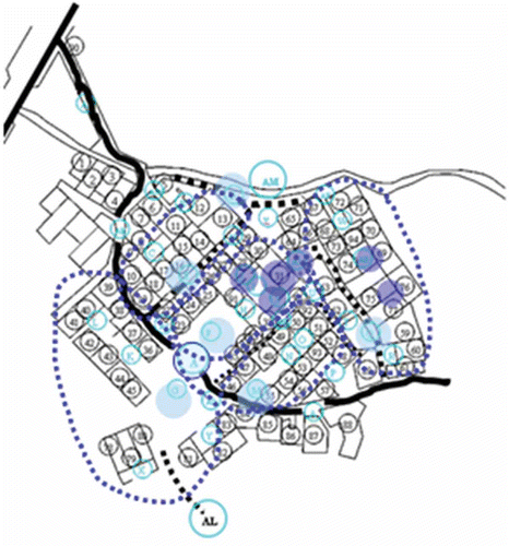
Figure 7. Nodes of Fanglan settlement.
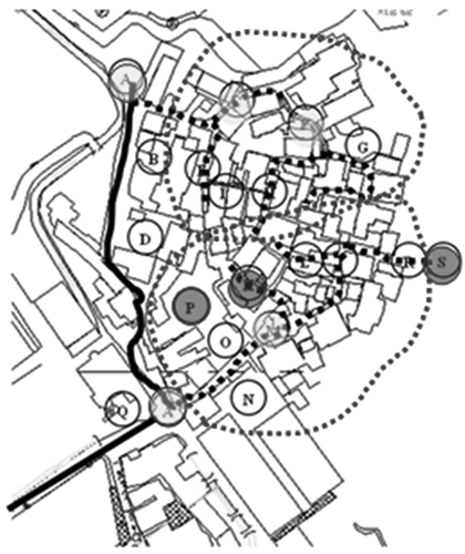
Figure 8. Spatial topology diagram of Dajia settlement.
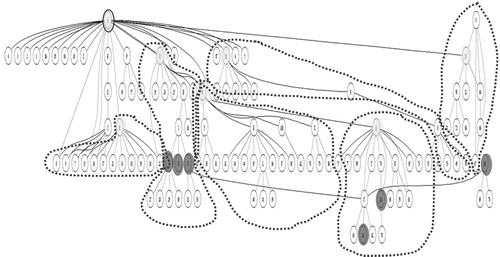
Figure 9. Spatial topology diagram of Fanglan settlement.
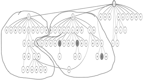
Figure 10. Statistics of Dajia settlement.
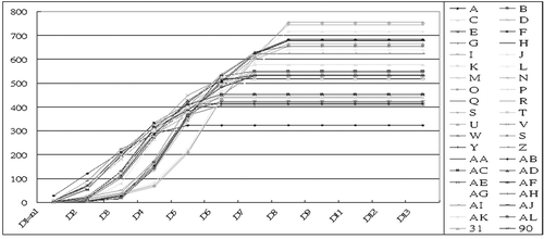
Figure 11. Statistics of Fanglan settlement.
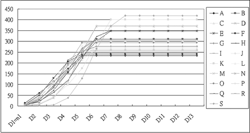
Figure 12. Saturated nodes of Dajia settlement.
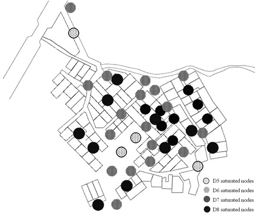
Figure 13. Saturated nodes of Fanglan settlement.
6. Research findings and discussion
The following findings and discussions are based on the results in the previous section.
-
Both cases show that the nodes of main paths, which are denoted by A, are earliest saturated and have the lowest depth. In many traditional settlements, buildings and open spaces are connected to the outside areas through main paths. That means that the main paths are likely to be the most accessible nodes, thus the center of settlement. In our study, both cases support the conjecture that the node being earliest saturated and with the lowest depth tends to be the center of settlement.
-
The nodes that are of the 20% early saturated are closely located to central zones in settlements. On the contrary, the 20% latest saturated nodes form peripheral areas.
-
Settlements can be divided into several subregions by the secondly saturated nodes, which can be thought of as gateways for subregions to access the central zones. For instances, nodes Q, F, E, D, G, and M are gateways of the case 1, whereas nodes C, M, and F are of the case 2. These gate ways are corresponding to front courtyards or major roads.
-
The latest saturated nodes coincide with not only peripheral areas but also private places, such as the inner courtyard within building sites and the shrine for offering sacrifices to gods or ancestors, which are not open to the public. In the case study, they are nodes AA, AB, AJ, 31, S, and J, in the case 1; nodes S, K, and P in the case 2. This finding argues that the opposition of centrality may not be peripherality when spatial elements other than road system are also taken into account. Thus, the meaning of saturation, which reflects a mixed concept of centrality/publicity versus peripherality/privacy, needs further study and exploration.
-
The results of these two case studies are compatible with the theory of city image proposed by Lynch (Citation1960), although the terms used are different. The settlement centers, the last saturated nodes, and subregions are corresponding to main paths, edge, and districts in Lynch's theory, respectively. It is noted that Lynch did not mention about the private places identified in this research.
-
At present, the theoretical experiment in this study is based on the structure of 15 points that are grouped into eight groups. The analytical results are tested using the two case settlements in Taiwan. It is found that these two villages with different sizes match the findings of basic researches. Future researches may expand the empirical sample size to explore the applicable extent of theories.
-
Although this research considers space details and conducts field surveys, the result still preserve comparability without losing generality. That is, a set of general standards and procedures of identifying social spaces and constructing their topological relations can be set up. The results of different researches following the same general standards and procedures should be able to be compared in a meaningful way.
7. Conclusions
This research has re-constructed the mathematical expression of depth value mentioned by space syntax and further suggested the concept of saturation to define the central, peripheral, and private regions in settlements. After exploiting their mathematical properties, four conjectures have been raised and tested by two traditional Taiwanese settlements. Although further tests and mathematical proofs are still needed, some tentative conclusions can be summarized as follows:
-
Although space syntax mainly regards roads in axial map, this research also takes buildings, courtyards, bridges, shrines, bus stops, temporary markets, and so on, into account. In this way, social and cultural spaces can be considered.
-
Saturation is a new approach to identify accessibility, publicity, and centrality.
-
The central nodes calculated by space syntax and this research could be different but very close. Both of them possess properties of centrality. Thus, they form a central region together.
-
Nodes that are adjacent to central region and early saturated could be regards as gateways to subregions.
-
Later saturated nodes could be either edge areas, such as settlement boundary, or private place, such as inner courtyards. In other words, the opposition of centrality may not be peripherality. Thus, the meaning of saturation may be a mixture of centrality, peripherality, publicity, and privacy. Future research should address this issue.
Space representation and analysis are common interests shared by researchers in GIS and CAAD. In recent years, it can be found that methods and technologies that were independently developed in each field are integrated. This research explores the mathematical property of spatial topology, which is the common basis of GIS and CAAD, and tries to associate the quantitative results with the social and cultural space through experimental case study on two settlements. The preliminary results show that the topologically quantitative approach is very promising to supplement the conventionally qualitative approach in settlement study. It is expected that more case studies with different sizes and threshold values of firstly and latest saturated nodes should be done and further findings will be explored. Moreover, if the tendencies and conjectures mentioned in this article can be mathematically proved in a formal way, it will give a sound foundation for the theory of spatial structure.
References
- Abubakar, I. and Aina, Y.A., 2006. GIS and space syntax: an analysis of accessibility to urban green areas in Doha district of Dammam metropolitan area, Saudi Arabia. In: Proceedings of Map Middle East 2006, Dubai, UAE. http://www.gisdevelopment.net/proceedings/mapmiddleeast/2006/transportation%20and%20network%20analysis/mm06tra_79.htm (Accessed: 18 February 2008 ).
- Akin , Ö. 1986 . Psychology of architectural design , London : Pion .
- Asami, Y., et al., 2002. Introducing third dimension on space syntax: application on the historical Istanbul. CSIS Discussion Paper, 44. http://www.csis.u-tokyo.ac.jp/dp/44.pdf (Accessed: 2 June 2003 ).
- Bovill , C. 1996 . Fractal geometry in architecture and design , Boston : Birkhaudser Press .
- Bustard , W. 1999 . Space, evolution, and function in the houses of Chaco Canyon . Environment and Planning B; Planning and Design , 26 ( 2 ) : 219 – 240 .
- Do , E.Y.-L. and Gross , M.D. 2001 . Thinking with diagrams in architectural design . Artificial Intelligence Review , 15 : 135 – 149 .
- Eastman , C.M. 1989 . Architectural CAD: a ten year assessment of the state of the art . Computer-Aided Design , 21 ( 5 ) : 289 – 292 .
- Flemming , U. 1987 . “ The role of shape grammars in the analysis and creation of designs ” . In Computability of design , Edited by: Kalay , Y. 245 – 272 . New YorK : John Wiley & Sons .
- Gero , J. 1990 . Design prototypes: a knowledge representation schema for design . AI Magazine , : 26 – 36 . 1990 Winter
- Griffiths , S. 2008 . “ Some theoretical and methodological implications of space syntax methodology for historical GIS: the example of Greater London's suburban town centres ” . In Historical GIS 2008 , UK : University of Essex .
- Hillier , B. and Hanson , J. 1984 . The social logic of space , Cambridge : Cambridge University Press .
- Hillier, B., 1998. The common language of space: a way of looking at the social, economic and environmental functioning of cities on a common basis. http://www.spacesyntax.org/publications/commonlang.html#top
- Hillier, B., et al., 2007. Metric and topo-geometric properties of urban street networks: some convergences, divergences and new results. In: Proceedings, 6th international space syntax symposium, İstanbul, 2007. Available from(accessed 12 June 2009). http://www.spacesynt axistanbul.itu.edu.tr/papers/longpapers/001%20-%20Hillier%20Turner%20Yang%20Park.pdf
- Jiang, B. and Claramunt, C., 2002. Integration of space syntax into GIS: new perspectives for urban morphology. Transactions in GIS, 6 (3), 295–309. http://citeseerx.ist.psu.edu/viewdoc/summary?doi=10.1.1.15.7043 (Accessed: 12 June 2009 ).
- Kigawa , T. , Seo , K.W. and Furuyama , M. 2006 . A meaning of Baroque in terms of space syntax- finding a “Bridge” between cosmology and practicality in cities . Journal of Asian Architecture and Building Engineering , 5 ( 2 ) : 269 – 276 .
- Lee and Lin . 2007 . A space syntax analysis of settlements in Taiwan . Journal of Architecture , 60 : 27 – 45 .
- Lin, F.T., 2001. Graph Theory. http://web.bp.ntu.tw/webusers/ftlin/course/CAAD/graph1.doc (Accessed: 8 December 2001 ).
- Lynch , K. 1960 . The image of the city , Cambridge, MA : MIT Press .
- Maver , T. . CAAD futures ‘87: proceedings of the second international conference on computer aided architectural design futures . Eindhoven, The Netherlands.
- Mitchell , W.J. 1977 . Computer-aided architectural design , New York : Van Nostrand Reinhold .
- Mitchell , W.J. 1989 . The logic of architecture design, computation, and cognition , Cambridge, MA : MIT Press .
- Van Nes , A. 2007 . Centrality and Economic development in the Rijnland region: social and spatial concepts of centrality. 6th International space syntax symposium, Istanbul
- Sahni , S. 1981 . Concepts in discrete mathematics , 2nd , Fridley, MN : The Camelot Pub. Co .
- Simon , H.A. 1969 . The sciences of the artificial , Cambridge : MIT Press .
- Space Syntax Limited . 2007 . Confeego v2.0 London, , UK
- Stiny , G. 1978 . The Palladian grammar . Environment and Planning B , 5 : 5 – 18 .
- Sasada, T., 1980 http://interlab.env.eng.psaka-u.ac.jp/frame.htm
- Steadman , J.P. 1983 . Architectural morphology – an introduction to the geometry of building plans , London : Pion . ISBN 0850860865
- Su , C.F. 1999 . An introduction of space syntax, the digital and culture , Department of Architecture, Tunghai University .
- Wang , H.F. 2006 . Architectural intent and its vernacular process—A morphological study of the spatial planning concept in traditional settlements and courtyard houses in Huizhou, China. Ph.D thesis , Hong Kong : University of Hong Kong .
- Wang , W.-C. and Liao , H.-J. . Implementing space syntax in an open source GIS – GRASS GIS approach . Proceedings of the 6th International Space Syntax Symposium . Istanbul
- Yang, T., 2007. The fuzzy boundary: the spatial definition of urban areas. In: Proceedings, 6th international space syntax symposium, Istanbul, 2007. http://www.spacesyntaxistanbul.itu.edu.tr/papers/longpapers/091%20-%20Yang%20Hillier.pdf (Accessed: 12 December 2009 ).
- Yu , H. , Tsou , J.-Y. and He , J. . Space syntax analysis of old communities in Hong Kong: a case study in Sai Ying Pun . Digital proceedings of the 14 IUSAM conferences .