Abstract
The Austin–San Antonio Corridor, which encompasses the Austin metropolitan area and the San Antonio metropolitan area, has experienced a significant increase of commute traffic since 1990. Previous research suggested that the level of traffic congestion in the corridor increased significantly in the past two decades. An analysis of the commute patterns would help better understand the underlying causes of traffic congestion and provide information for urban planning and traffic management. Based on the US Census Transportation Planning Package Part 3 Journey-to-Work data for 1990 and 2000, this study developed a set of GIS-based methods to analyze the spatial and temporal change of commute patterns and commute flows in the Austin–San Antonio Corridor. The analyses revealed communities that experienced a significant increase of commute traffic and identified major travel corridors that carry a high proportion of the traffic in the area. The findings from this study should be particularly useful to public transportation providers seeking information for improving the coordination of rural-to-urban public transportation services.
1. Introduction
In the past several decades, rural areas in America have undergone great change (Rosenbloom Citation2003). Improvements in communication technology and attraction of rural amenities encouraged the growth of rural communities. Workers' desire to find cheaper housing while accessing jobs in urban areas led to the sprawl of metropolitan areas to adjacent rural counties. These trends contributed to a phenomenon of increasing intercity or rural-to-urban commuting.
According to the US 2000 Census, 75.7% of the commuters drove to work, 12.2% chose carpooling, and only 4.7% used transit in the nation in 2000. The number of people using private auto to commute for work was nearly three times of that in 1960. The average vehicle occupancy rate for commute trips was only 1.08. Another trend was that commuters made longer trips in their journeys to work (McGuckin and Srinivasan Citation2003). These numbers reveal that commuters prefer using private vehicles as a means of traveling to work. This is not surprising in rural and suburban areas because the residents in those areas usually have few transportation alternatives.
On the other hand, public transit services have not kept up with the growing demand of mobility and accessibility in rural and suburban communities (Bogren Citation1996). In small urban and rural communities, 41% of the residents had no access to public transportation and another 25% received below-average transit services (Community Transportation Association of America Citation1998). The lack of efficient transit connections between residence locations and work places and the high dependency of private autos contribute a lot to roadway congestion and deteriorating air quality. Although journey-to-work trips do not account for a majority of travel in the United States, heavy congestion typically happens during the peak hours when people are on their way to and from work (Horner Citation2004). As observed, traffic congestion in rural and small urban areas increased 11% annually, which is twice the rate in urban areas (Community Transportation Association of America Citation2001).
Texas faces the same set of problems. In metropolitan areas, such as Austin, San Antonio, Houston, and Dallas/Fort Worth, a lot of commuters travel outside of the urban areas for work, goods, or other services. In many cases, different transit services operate separately, with different fare structures, few or no transfer points from one system to another, and sometimes with different ridership eligibility. As a consequence, for those people who need to travel across different jurisdictions, public transit often manifests as an inconvenient mode of transportation. In the Austin metropolitan area and the San Antonio metropolitan area, 75% of the workers drove to work alone, 14%–15% chose carpooling, and 3% used transit in 2000 (McGuckin and Srinivasan Citation2003). In the Dallas–Fort Worth metropolitan area and the Houston–Galveston–Brazoria metropolitan area, 78% of the commuters drove to work, 14% used carpooling, and only 2%–3% chose transit (McGuckin and Srinivasan Citation2003). The rate of automobile dependency in these areas is higher compared with the national average. According to an urban mobility study by the Texas Transportation Institute (TTI), the level of traffic congestion in the Austin urban area increased relatively faster than that of similar metropolitan areas with 500,000–1,000,000 population during the period from 1982 to 2002 (Texas Transportation Institute Citation2004). Changes in commuting patterns in Texas metropolitan areas are attributed to the locations of available jobs, housing choices, and the availability of different transportation modes.
Based on these commuting trends, this article examines the spatial and temporal changes of commuting patterns from 1990 to 2000 in Central Texas through an analysis of the Census Transportation Planning Package (CTPP) data. This study provides insights about how the spatial distribution of commuters, commute times, inter-county commute traffic, and major travel corridors has changed in the area during the 10-year period. Findings from this study help identify areas with increasing commute traffic and major travel corridors in the Austin–San Antonio Corridor, therefore, providing important information for public transportation providers and other stakeholders to improve the coordination of rural-to-urban public transportation services.
2. Related work
Commute patterns are often closely related to urban development and accessibility to jobs and transit services. It has been widely acknowledged that urban land use shapes travel patterns and, in turn, transport systems and their associated movements affect land use patterns as well (Hanson and Giuliano Citation2004). Since the completion of the Interstate Highway System in the United States in the 1980s, suburban living has become a popular choice of housing. Therefore, through the analysis of travel patterns, it is possible to examine urban land use trend and how it impacts the commutes of peoples.
Study on commute patterns has been performed at the national level as well as at the regional scales. At the national level, McGuckin and Srinivasan (Citation2003) provided a comprehensive report on the changes of commute patterns from 1960 to 2000. Focusing on the country as a whole and the major metropolitan areas in the United States, they examined the changes in several aspects, including population and demographics, workforce composition, transportation mode to work, time of travel to work, vehicle ownership, and commute flows. One of the major changes was that more and more commuters have become auto-dependent and travel time in all metropolitan areas has shown a significant increase. Comparing with 1990, workers in major metropolitan areas spent 45–60 minutes more on way to their workplace in 2000. The McGuckin and Srinivasan study focused the analyses at the county level. In addition, their analyses were basically descriptive and nonspatial.
At the regional level, most studies focused on metropolitan areas. In the early 1990s, Levine (Citation1992) investigated how suburban employment influenced the commute patterns of households with different income levels in the San Francisco Bay Area. The study suggested that lower-income households tended to travel longer than higher-income households during the large-scale suburbanization of employment. In another study for the same area, Cervero and Wu (Citation1997) found that people who worked in suburban centers spent less time on commute than those who worked in larger urban centers. They pointed out that the increase of commute time was due to the displacement of worker from employment centers with higher housing prices to suburban centers with cheaper housing prices.
In the study of Birmingham and Tuscaloosa, Alabama, Sultana and Weber (Citation2007) had similar findings. They found that workers living in sprawling areas had longer commute trips than those living in denser urban areas. However, they observed that people who lived in suburban areas but worked in urban areas experienced the longest commute to work. Therefore, urban sprawl would not necessarily increase commute time if sprawl residents could locate jobs in the sprawl area. In a study of the relationship between commute time and proximity to employment opportunities in the New York metropolitan area, Macek et al. (Citation2001) found that transit commuters spent more time than commuters using private vehicles on commute. They further pointed out that people with private vehicles had greater employment opportunities than those reliant on transit for commuting. These studies suggest that job and housing opportunities have great impact on commute patterns and vice versa.
Based on the National Household Travel Survey data, Public Use Micro-Survey data, and the CTPP data, Lang and Nelson (Citation2007) explored commute patterns in 10 metropolitan regions. Based on the population projection and jobs by place of work from the US Census Bureau and Woods & Poole Economics, Inc., they further estimated future commute changes. As the main purpose of their study was to use commuting data to predict megapolitan formation in the United States in the next 30 years, the study focused on commute flows between different counties for selected metropolitan regions. It did not reveal commute patterns at finer scales. Nevertheless, for the Austin–San Antonio Corridor, they pointed out that places northeast of San Antonio region had been increasingly integrated with Austin, and Austin had been growing southward along Interstate Highway 35 (I-35) toward San Antonio. In a very recent study titled ‘Changes in transportation infrastructure and commuting patterns in U.S. metropolitan areas, 1960–2000’, Baum-Snow (Citation2010) suggested that employment decentralization was accompanying residential decentralization between 1960 and 2000. As a result, most commutes of metropolitan residents were not necessarily from central cities.
In addition to these studies on commute patterns, it is worth noting that there have been many studies on job accessibility, excess commuting, or spatial mismatch of job and home locations using commute data (Taylor and Ong Citation1995, Wang Citation2000, Horner and Mefford Citation2007, Kawabata and Shen Citation2007, Yang Citation2008). The focus of this study is on the spatial and temporal change of commute patterns; we do not provide a review of these studies in this article.
3. Methodology
3.1. Study area
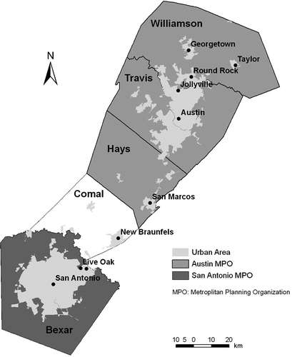
The study area covers five counties, Bexar, Comal, Hays, Travis, and Williamson, in the Austin–San Antonio Corridor in Central Texas (). This is one of the fastest growing areas in Texas. This area encompasses two metropolitan areas: the Austin metropolitan area and the San Antonio metropolitan area. The Austin metropolitan area includes three counties, Williamson, Travis, and Hays. The City of Austin is located in Travis County. Austin is the capital of the State of Texas and home to many high-technology companies. The city was ranked as the third fastest growing large city in the United States from 2000 to 2006 (Christie Citation2007). The San Antonio metropolitan area consists of Bexar County only. The City of San Antonio was ranked just behind Austin as the fourth fastest growing large city from 2000 to 2006 (Christie 2007). Comal County connects the Austin metropolitan area with the San Antonio metropolitan area. As can be seen from , the majority of the urban area in the study area is located in Travis County and Bexar County. The two cities, drawing people along the corridor, have been showing a growing trend of convergence. I-35, connecting Austin and San Antonio, has long been recognized as one of the state's most congested highways.
Figure 1. Study area – Austin–San Antonio Corridor.
3.2. Data
3.2.1. CTPP Part 3 Journey-to-Work data
The analyses were based on the CTPP Part 3 Journey-to-Work data (Bureau of Transportation Statistics 2000). The CTPP Part 3 data include a set of tables that summarize major journey-to-work characteristics at different aggregation levels, ranging from state level, county level, area units of different places, and traffic analysis zones (TAZs). TAZs are defined specifically for traffic analysis by state and regional transportation agencies. Only CTPP data give information related to journey-to-work at the TAZ level.
In CTPP Part 3 database, each table contains information about one variable related to commute trips. Examples include the total number of workers/vehicles, the socioeconomic characteristics of workers, the number of workers with regard to travel modes, and the average travel time. The data are summarized for each unique pair of residence and workplace. To analyze the commute trends from 1990 to 2000, we used the tables including information about the number of workers based on their residence and workplace locations, the average travel time used in journey-to-work trips based on residence and workplace locations, and the number of vehicles used in journey-to-work trips. It shall be noted that the 1990 CTPP data do not provide commute trip information between the Austin metropolitan area and the San Antonio metropolitan area. The reason is not clear to us. Therefore, it was only possible to analyze and visualize the commute patterns in 1990 for these two metropolitan areas separately.
3.2.2. GIS map layers of census traffic analysis zones
To visualize the spatial and temporal variations of the statistical information at the TAZ level, it is necessary to associate values of these variables with their corresponding TAZs. We downloaded Census TAZ shapefiles of the counties in Austin–San Antonio Corridor from Environmental Systems Research Institute (ESRI; http://www.esri.com/data/download/census2000-tigerline/index.html) and used the shapefiles as the GIS map layers for the analysis and visualization. A shapefile, defined by ESRI, is a specific format of storing geographic data in digital forms (ESRI Citation1998). Once we have the CTPP Part 3 data tables and the GIS map layers at the TAZ level, we are ready to prepare the data for subsequent analyses.
3.3. Data analysis
3.3.1. Distribution of commuters based on residence and workplace
By linking the TAZ numbers in the CTPP Part 3 data tables with the TAZ numbers in the TAZ shapefile, we are able to map the distribution of commuters based on residence and workplace locations. However, one issue related to the 1990 CTPP Part 3 dataset is that it does not contain information for each TAZ as the 2000 CTPP Part 3 dataset does. In some situations, the 1990 data were recorded for places rather than for TAZ. This situation was observed mostly in the data about Hays County and Williamson County. Because the geographic coverage of places is usually larger than TAZs, it is not meaningful to compare statistics between the two geographic levels. Given the majority of the areas without information at the TAZ level are located in rural areas, we removed these rural areas from the 1990 CTPP dataset to make the results of the comparison more reliable.
Instead of mapping the geographic distribution of workers using absolute numbers, we performed a density analysis of the number of workers based on their residence and workplace locations using the 1990 and 2000 datasets. We interpolated the number of workers using a kernel density function. Rather than simply dividing the number of workers by the area of a geographic unit, kernel density analysis uses a spread function of the known feature to estimate the values of other unknown features within a specified radius. It is worth noting that different spread functions can be used to produce different smoothing effects. However, no matter what function is used, the underlying assumption is that density is the greatest at the known feature. It decreases with increasing distance from the known feature, and its value drops to 0 at the specified radius. Therefore, a kernel density produces a smoother distribution of the value in question than the simply density. For each output cell, the overall density is obtained by summing up the intersecting spreads. Although various interpolation functions are available for kernel density analyses, we used the quadratic kernel function developed by Silverman (Citation1986). It is one of the most widely used kernel density functions.
To identify the communities that experienced an increase or decline of commuters from 1990 to 2000, we computed the difference between the density maps of 2000 and 1990 to generate the density change maps based on both residence and workplace locations. The density change maps give a clear picture about the change patterns of the distribution of commuters from 1990 to 2000.
3.3.2. Average travel time
The CTPP part 3 data contain average travel time with regard to residence and workplace locations at the TAZ level. Based on the TAZ identification number, we linked the average travel time from the CTPP Part 3 datasets with the TAZ shapefile. For both 1990 and 2000, a map showing the average travel time associated with worker's residence and workplace locations was generated.
3.3.3. Analysis of inter-county commute flows
Inter-county commute flows refer to traffic flows that originate and end in different counties. Although it is obvious that Travis County and Bexar County attract more traffic from the other counties, an analysis of the change of inter-county commute flows can help us identify which county experienced the most growth of decline of inter-county commute inflows and outflows in the study area. This task was implemented based on the trip origin and destination information in the CTPP datasets. We summarized the inter-county commute flows between each two counties in the study area. Because the 1990 CTPP data do not contain information for the commute traffic between the Austin metropolitan area and the San Antonio metropolitan area, we were only able to compute the inter-county commute flows for the two metropolitan areas for 1990.
3.3.4. Identification of travel corridors
The goal of travel corridor analysis is to identify the routes that carry a significant amount of commute traffic in the study area. The calculation of traffic volume was based on the number of commute vehicles from the CTPP datasets. This study considered the total number of vehicles used in commute on a daily basis. To implement this task, we developed a network analysis model to summarize the traffic volumes for the road network in ArcGIS 9.3 (). The flowchart in shows the steps used to identify the travel corridors.
Figure 2. Procedures for identifying travel corridors.
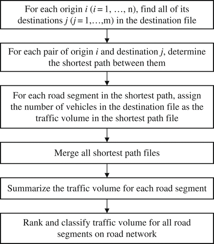
First, we set the centroid of a residence TAZ as a trip origin. Second, the centroids of all the workplace TAZs associated with the residence TAZ were set as designations. Then based on the Closest Facility Solver in ArcGIS 9.3, we identified the shortest paths from the trip origin to all destinations. The shortest path can be determined based on either the shortest travel distance or the shortest travel time. In this study, we defined the speed limits of roads according to road classifications and used shortest travel time in the analysis. Once we obtained the shortest path between a pair of origin and destination, the number of vehicles associated with that commute trip was assigned to each road segments in the shortest path. We wrote a Visual Basic for Applications (VBA) script to implement this task. Then we determined the total traffic volume for a road segment by summing up the number of vehicles that pass through that road segment in all shortest paths.
It shall be noted that we did not consider congestions, the shortest paths were determined based on a free-flow mode. Although this assumption is not ideal, the results could nevertheless provide us a clear picture of the pressure on major roads. It is also worth noting that the number of commute vehicles associated with each TAZ includes all vehicles used in the commute on a daily basis, regardless of the starting time of the trips. Therefore, the traffic volume assigned to each road is a representation of the overall daily commute traffic. The traffic volume does not suggest the traffic condition at any particular time of a day. Based on the traffic volume of each road segment, we were able to identify and visualize travel corridors that carry a significant amount of traffic in the study area. Because no data were available for 1990 regarding the commute traffic between the Austin metropolitan area and the San Antonio metropolitan area, we were unable to map any commute flows between the two metropolitan areas.
We are aware that the approach of determining traffic assignment based on the shortest paths between trip origins and destinations may not yield results that closely reflect the actual traffic flows on the network. Commuters may not necessarily follow the shortest paths in their journeys from home to work. On the contrary, commuters might change their routes for other reasons, for example traffic jams. Approaches to estimating traffic flows include the equilibrium approach (Hanson and Giuliano Citation2004), aerial photography, and remote sensing. Real traffic data, for example, average daily traffic (ADT) counts, could be used to represent traffic flows and help visualize the major travel corridors in the study area. Because there were no ADT data in 1990 and 2000, it was not possible to make a direct comparison between the real traffic counts and the estimated flows on different segments of the network based on the 1990 and 2000 census data.
Instead, this study obtained the 2005 traffic counts data (ADT data) from the Capital Area Metropolitan Planning Organization (CAMPO) of Texas (CAMPO Citation2010) and compared it with the traffic volumes computed for 2000. This is not ideal. But the comparison would help examine the reliability of the results. The CAMPO 2005 ADT data contain traffic counts for Williamson County, Travis County, and Hays County. Because the road network dataset in the ADT data is not identical to the road network dataset in this study, it is impractical to match each road segment in these two datasets. As an alternative, we selected the top 100 road segments with the highest traffic counts and then compared the traffic counts. It is worth noting that ADT counts include both commercial and noncommercial vehicles. This study only focuses on commuting vehicles. Therefore, it is reasonable to expect discrepancies between the two datasets.
4. Results
4.1. The spatial and temporal change of the distribution of workers
As can be seen in , it is very clear that the northern, northwestern, and southern parts of Travis County attracted more workers who lived there in 2000 compared with those who lived there in 1990. The expansion of residential houses outside of the urban area in San Antonio, although not as obvious as that in Austin, shows a trend of an increasing number of workers living in the north and northwestern areas of Bexar County. The density change map clearly reveals different patterns of residential sprawl in the two metropolitan areas (). In Travis County, it is evident that residential development sprawled from central city and extended around major roadways. The expansion was mainly along I-35, US Highway 183, and US Highway 290. To the north and northwest, most significant growth took place in areas from Pflugerville to Round Rock and Leander. To the south, it expanded from the central area to Sunset Valley, Tanglewood Forest, San Leanna, and all the way to the border with Hays County. In Bexar County, the expansion occurred mainly around northern and northwestern areas of the county between I-410 and Loop 1604, including places such as Hollywood Park, Leon Valley, Castle Hills, and Shavano Park. Another interesting observation is that the central part of San Antonio experienced a decline of the number of workers living there, whereas the urban area of Austin attracted more workers during the same time period.
Figure 3. Distributions of workers based on residence locations: (a) 1990; (b) 2000.
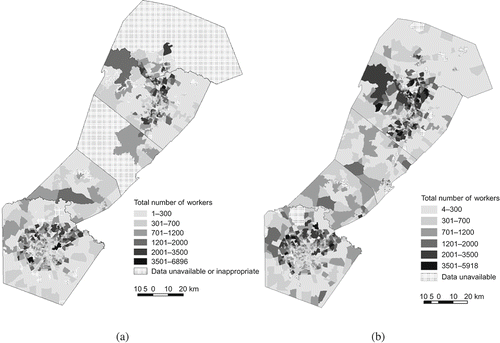
Figure 4. Density change of the distribution of workers based on residence locations.
In the other three counties, the City of Georgetown, the City of Round Rock, and the City of Taylor in Williamson County, and the City of San Marcos in Hays County all attracted more workers to live there. This pattern is much less obvious for the City of New Braunfels in Comal County (). We shall note that the areas with noticeable decreasing density in Hays County and Williamson County are simply the results of inaccurate data at the place level. Therefore, the density change in these areas could not be used to explain the change patterns in these two counties.
With regard to workplace, major concentrations of workplaces were in the urban areas of Travis County and Bexar County for both 1990 and 2000 (). This is not hard to understand as urban centers usually provide many employment opportunities. However, the density change map reveals a pattern of decline in the number of workers with offices in the central and southern areas of San Antonio whereas Austin experienced significant growth in its urban areas (). The growth of workplaces in Bexar County corresponded to the trend of residential development. It occurred mainly in the northern and northwestern areas around I-10, I-410, and US Highway 281, although somewhat less extensive than the sprawl of residential development. An examination of residence and workplace change reveals that the area from Kirby to Live Oak experienced a decline of residential dwellings but filled with more employments. In the Austin area, the number of workplaces grew along almost all major roadways, such as I-35, US Highway 183, State Loop 1, and US Highway 290, similar to the pattern of residential development in the city. However, the expansion was less extensive than that of the residence. For example, significant growth of residential development can be observed all the way to Leander in northwest Austin and to San Leanna in the south. But the expansion of workplaces in these two directions only went toward Cedar Park and Sunset Valley. It was also noted that the area between Austin and Round Rock saw significant growth in offices.
Figure 5. Distributions of workers based on workplace locations: (a) 1990; (b) 2000.
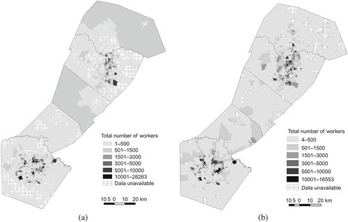
Figure 6. Density change of the distribution of workers based on workplace locations.
4.2. The change of average commuting time
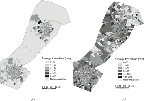
The average commuting time increased significantly from 1990 to 2000. Workers spent much more time on their journeys from home to work in 2000. Based on residence locations, the average travel time for most workers in 1990 was within 30 minutes (). In 2000, the average travel time of most workers exceeded 30 minutes. Some commuters even spent almost 3 hours on their way to work. shows a clear pattern that people who lived in rural areas spent significantly more time on commute. This situation got worse in 2000, particularly for those who lived in Comal County, Hays County, and Williamson County. Based on workplace locations, we can see that as people tend to work across counties, the average travel time also increased significantly (). People who had their workplaces in rural areas obviously spent more time on commute than those who had their jobs in urban areas in 2000 (). also suggested that the interchange between rural and urban areas grew extensively from 1990 to 2000.
Figure 7. Average travel time based on residence locations: (a) 1990; (b) 2000.
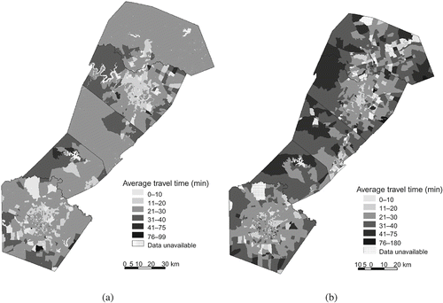
Figure 8. Average travel time based on workplace locations: (a) 1990; (b) 2000.
4.3. The change of inter-county commute flows
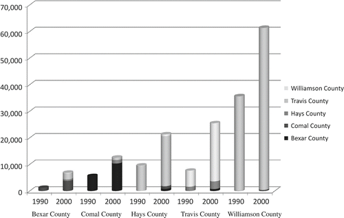
The inter-county commute flows in the study area grew significantly from 1990 to 2000 (). In each county, the total volume of inter-county commute flows in 2000 was almost twice as much of that in 1990. In the two metropolitan areas, Austin and San Antonio by no means attracted the most inter-county commute flows from their surrounding counties. It is noticeable that commute inflows to Travis County were mainly from Hays County and Williamson County. In the case of Bexar County, the majority of commute inflows came from Comal County. In 2000, the commute flows between Travis County and Bexar County accounted for only 2.3% of the total inter-county commute flows in the area. We can also see that there were more commuters traveling from Bexar County to Travis County than the other way round in 2000. These findings suggest that although there is a growing trend of convergence between the two metropolitan areas, the inter-county commute flows in the study area were clearly between the two metropolitan areas and their adjacent counties, and Austin received much more commute inflows from other counties than San Antonio. Within the Austin metropolitan area itself, we can see that although Travis County received its commute inflows from both Hays County and Williamson County, the commute outflows from Travis County mainly went to Williamson County. This pattern did not change much during the 10-year period.
Figure 9. Estimated inter-county commute flows.
4.4. Major travel corridors
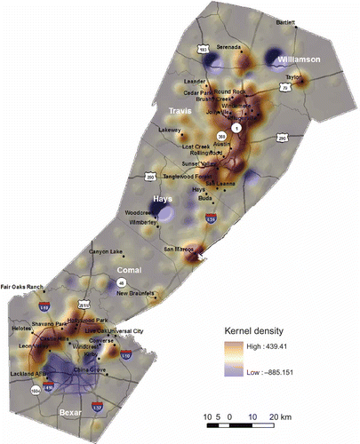
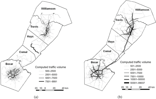
Although inter-county commute flow analysis can provide an overall picture of the commute flows between counties, a travel corridor analysis can present more details regarding where we may expect heavier traffic over the road networks in the area. shows the overall distribution of the major travel corridors in 1990 and 2000. As mentioned earlier, the 1990 data do not contain commute information between the two metropolitan areas. Therefore, we were unable to map any travel corridors between Comal and Hays counties. We can see that commute traffic was concentrated in two geographic areas in the study area: (1) Williamson–Travis–Hays and (2) Bexar–Comal. However, the roads that carried heavy traffic were mainly within the urban areas of the two metropolitan cities in 1990, whereas in 2000, we can see that not only the traffic within each metropolitan city grew significantly outward, but also the traffic on the highways that connect the counties in the two geographic areas increased significantly. It was quite evident that the section of I-35 between Comal and Bexar, Hays and Travis, Travis and Williamson, as well as the section of US-183 between Travis and Williamson counties carried significantly more commute traffic in 2000 than in 1990. This pattern is expected and corresponds to the observations of inter-county commute flows. also suggests that I-35 in Central Austin carries the high proportion of commute traffic when compared with other major highways in the five-county area.
Figure 10. Major travel corridors: (a) 1990; (b) 2000.
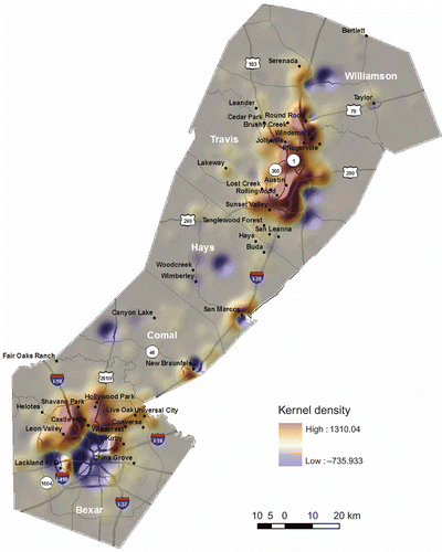
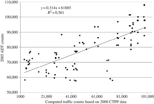
To examine the reliability of the traffic counts calculated in this study, this study selected 100 road segments with the highest traffic counts and compared the traffic volumes. First, we selected 100 road segments with the highest traffic counts in 2000 in this study. About 80 of the 100 road segments ranked among the top 100 road segments in the 2005 ADT data. Then based on the top 100 road segments with the highest ADT counts, we compared the traffic counts with the traffic counts computed in this study. As can be seen from , there is an obvious positive relationship between the two datasets. The traffic volumes computed in this study tend to be lower than the ADT counts. In addition to the issues related to using shortest path in traffic assignment, this could also be attributed to the time discrepancy and non-commuting vehicles involved in the ADT data. When examining the traffic volumes of road segments with low traffic, we found that the computed traffic volumes tend to be much less than that observed. Using shortest travel time instead of shortest travel distance in traffic assignment somewhat helped avoid assigning unrealistic large volumes of traffic to road segments with small capacities. In summary, the comparison suggested that the major travel corridors were well captured in this study.
Figure 11. Comparison of the traffic volumes for selected road segments.
5. Conclusions
The growth of commuting traffic from rural communities to urban centers creates heavier traffic and therefore contributes to traffic congestion along some travel corridors. As a fast-growing region in Texas, the Austin metropolitan area and the San Antonio metropolitan area experienced significant changes of commute traffic from 1990 to 2000. Utilizing a set of GIS-based methods, this study revealed the spatial and temporal changes of commute patterns and commute flows from different perspectives in Central Texas, including the geographic distribution of commuters and commuting vehicles in rural and urban communities, the average travel time between home and job locations, and inter-county commute flows. This study developed a GIS-based network analysis model to identify major travel corridors that carried a significant volume of commuting traffic in Central Texas. The GIS-based analyses in this study are effective for analyzing commuting patterns and travel corridors and are applicable to other areas. We are aware that due to the limitation of the data, we were unable to map the commute flows between the two metropolitan areas in 1990. Thus it was not possible to compare the change of commute flows across the two metropolitan areas from 1990 to 2000.
The analyses revealed a number of interesting patterns. First, the residence locations of commuters extended significantly around major roadways after 1990. For the Austin metropolitan area, the growth exhibits a dumbbell pattern expansion with significant growth along the III-35 corridor and in areas close to Williamson County and Hays County. For the San Antonio metropolitan area, significantly more workers resided in the northwestern area of San Antonio in 2000 than in 1990. Contrary to the growth pattern in Austin, the central part of the San Antonio metropolitan area did not experience significant growth. Second, the change of workplace locations shows a clear clustering pattern along several major expressways. In Austin, offices in the area north of Ben White Boulevard, extending well into Round Rock, attracted a significant number of workers after 1990. It demonstrated a strong and increasing connection between Austin and Round Rock. The findings also revealed a significant growth of jobs in the area west of I-35 in Austin after 1990. In San Antonio, the area that experienced significant growth of workplaces corresponded well with the pattern of residential development that clustered along I-10 and US-281 in the northwestern suburbs of the city. The central part of the city did not experience much growth of jobs.
Third, the average commuting time increased considerably with regard to both residence and workplace locations from 1990 to 2000. Comparing with 1990, most workers spent more than half an hour in their commute. People who lived in rural areas spent significantly more time on commute than people who lived in urban areas, particularly for those who lived in Comal County, Hays County, and Williamson County. On the contrary, people who worked in rural areas also spent more time on commute than those who had jobs in urban areas. This phenomenon was more obvious in 2000. Fourth, the total volume of inter-county commute flows in 2000 was almost twice of that in 1990. However, the inter-county flows were mainly among counties within the two metropolitan areas. There were very few traffic flows between the two metropolitan areas. This is true for both 1990 and 2000. Fifth, the total traffic volume increased considerably from 1990 to 2000 in the study area. The growth of the major travel corridors can be explained as results of the expansion of residence places and workplaces, as well as increasing inter-county commute flows. The highways that connect the counties in their respective metropolitan areas received significantly more traffic in 2000 than in 1990.
These findings provide us a clearer picture of the spatial and temporal changes of commute patterns in the Austin–San Antonio Corridor from 1990 to 2000. It helped us achieve a better understanding of the characteristics of commute trends in Central Texas. Although the intention of this study was to examine the spatial–temporal change of commute patterns in Central Texas, future studies investigating the relationship between urban development and commute pattern changes over time can provide more insights about the impact of urban structure on commute behaviors.
Acknowledgments
The study reported in this article was in part supported by a grant from the Texas Department of Transportation (TxDOT) (Project No. 0-5345). Part of this article was written while F. Benjamin Zhan was visiting Wuhan University in China as a Chang Jiang Scholar Guest Chair Professor. Support by the Chang Jiang Scholar Awards Program and Wuhan University is greatly appreciated.
Notes
References
- Baum-Snow, N., 2010. Changes in transportation infrastructure and commuting patterns in US metropolitan areas, 1960–2000 [online]. 2010 American Economic Association Meetings in Atlanta, GA http://www.econ.brown.edu/faculty/Nathaniel_Baum-Snow/aer_pandp_baumsnow.pdf (http://www.econ.brown.edu/faculty/Nathaniel_Baum-Snow/aer_pandp_baumsnow.pdf) (Accessed: 20 June 2010 ).
- Bogren , S. 1996 . Work trips take new routes . Community Transportation Reporter , 14 ( 8 ) : 12 – 17 .
- Capital Area Metropolitan Planning Organization (CAMPO). 2010. Regional data [online] http://www.campotexas.org/programs_gis.php (http://www.campotexas.org/programs_gis.php) (Accessed: 25 October 2010 ).
- Cervero , R. and Wu , K.-L. 1997 . Polycentrism, commuting, and residential location in the San Francisco Bay area . Environment and Planning A , 29 ( 5 ) : 865 – 886 .
- Christie, L. 2007. The fastest growing US cities: From the empire state to the lone star state - the cities that are growing the most [online]. Cable News Network (CNN) http://money.cnn.com/2007/06/27/real_estate/fastest_growing_cities/ (http://money.cnn.com/2007/06/27/real_estate/fastest_growing_cities/) (Accessed: 24 July 2008 ).
- Community Transportation Association of America (CTAA). 1998. Rural transit: You can get there from here. Community transportation association of America Research Center [online] http://www.ctaa.org/webmodules/webarticles/articlefiles/ct/spring98/rural_transit.pdf (http://www.ctaa.org/webmodules/webarticles/articlefiles/ct/spring98/rural_transit.pdf) (Accessed: 13 October 2010 ).
- Community Transportation Association of America (CTAA). 2001. Full steam ahead for reauthorization [online] http://www.ctaa.org/webmodules/webarticles/articlefiles/ct/summer01/reauthorization_strategy.pdf (http://www.ctaa.org/webmodules/webarticles/articlefiles/ct/summer01/reauthorization_strategy.pdf) (Accessed: 13 October 2010 ).
- Environmental Systems Research Institute, Inc. (ESRI), 1998. ESRI shapefile technical description [online] http://www.esri.com/library/whitepapers/pdfs/shapefile.pdf (http://www.esri.com/library/whitepapers/pdfs/shapefile.pdf) (Accessed: 20 November 2005 ).
- Hanson , S. and Giuliano , G. , eds. 2004 . Geography of urban transportation , New York, NY : Guilford Press .
- Horner , M.W. 2004 . Spatial dimensions of urban commuting: A review of major issues and their implications for future geographic research . Professional Geographer , 56 ( 2 ) : 160 – 173 .
- Horner , M.W. and Mefford , J.N. 2007 . Investigating urban spatial mismatch issues using jobs-housing indicators to model home-work separation . Environment and Planning A , 39 ( 6 ) : 1420 – 1440 .
- Kawabata , M. and Shen , Q. 2007 . Commuting inequality between cars and public transit: The case of the San Francisco Bay Area, 1990–2000 . Urban Studies , 44 ( 9 ) : 1759 – 1780 .
- Lang, R. and Nelson, A., 2007. Beyond the metroplex: Examining commuter patterns at the ‘megapolitan’ scale [online]. Lincoln Institute of Land Policy http://www.china-up.com/international/case/case/398.pdf (http://www.china-up.com/international/case/case/398.pdf) (Accessed: 14 June 2010 ).
- Levine , J.C. 1992 . Decentralization of jobs and emerging suburban commute . Transportation Research Record , 1364 : 71 – 80 .
- Macek , N.M. , Khattak , A.J. and Quercia , R.G. 2001 . What is the effect of commute time on employment? Analysis of spatial patterns in New York metropolitan area . Transportation Research Record , 1780 : 43 – 52 .
- McGuckin, N.A. and Srinivasan, N., 2003. Journey to work in the United States and its major metropolitan areas 1960–2000 [online]. Federal Highway Administration (Publication No. FHWA -EP-03-058) http://www.fhwa.dot.gov/ctpp/jtw/ (http://www.fhwa.dot.gov/ctpp/jtw/) (Accessed: 15 March 2005 ).
- Rosenbloom , S. 2003 . The changing demographics of rural America: What are the implications for transportation providers? . TR News , 225 : 12 – 17 .
- Silverman , B.W. 1986 . Density estimation for statistics and data analysis , New York, NY : Chapman and Hall .
- Sultana , S. and Weber , J. 2007 . Journey-to-work patterns in the age of sprawl: Evidence from two midsize southern metropolitan areas . Professional Geographer , 59 ( 2 ) : 193 – 208 .
- Taylor , B.D. and Ong , P.M. 1995 . Spatial mismatch or automobile mismatch? An examination of race, residence and commuting in US . Urban Studies , 32 ( 9 ) : 1453 – 1473 .
- Texas Transportation Institute (TTI), 2004. 2004 urban mobility report [online]. Texas Transportation Institute http://downloads.transportation.org/2004UrbanMobilityReport.pdf (http://downloads.transportation.org/2004UrbanMobilityReport.pdf) (Accessed: 15 March 2005 ).
- US Bureau of Transportation Statistics (BTS), 2000. CTPP 2000: CTPP 2000 part 3 [online] http://www.transtats.bts.gov/Fields.asp?Table_ID=1348 (http://www.transtats.bts.gov/Fields.asp?Table_ID=1348) (Accessed: 15 November 2005 ).
- Wang , F. 2000 . Modeling Commuting patterns in Chicago in a GIS environment: A job accessibility perspective . The Professional Geographer , 52 ( 1 ) : 120 – 133 .
- Yang , J. 2008 . Policy implications of excess commuting: Examining the impacts of changes in US metropolitan spatial structure . Urban Studies , 45 ( 2 ) : 391 – 405 .