Abstract
The exponential rise in urban population and the resulting urban waste generation in developing countries over the past few decades, and the resulting accelerated urbanization phenomenon has brought to the fore the necessity to engineer environmentally sustainable and efficient urban waste disposal and management systems. Intelligent and integrated landfill siting is a difficult, complex, tedious, and protracted process requiring evaluation of many different criteria. Optimized siting decisions have gained considerable importance in ensuring minimum damage to the various environmental sub-components as well as reducing the stigma associated with the residents living in its vicinity. This article addresses the siting of a new landfill using a multi-criteria decision analysis integrated with overlay analysis within a geographical information system. The integrated multi-criteria decision analysis–geographical information system employs a two-stage analysis, synergistically, to form a spatial decision support system for landfill siting in fast-growing urban centers. Several correlated factors are considered in the siting process including transportation systems, water resources, land use, sensitive sites, and air quality. Weightings were assigned to each criterion depending upon their relative significance and ratings in accordance with the relative magnitude of impact. The results, analyzed using neighborhood-proximity analysis, show the effectiveness of the system in the site-selection process for Eldoret Municipality (Kenya), in the short- and long-term solid waste disposal siting options.
1. Introduction and background
The rate of population growth in urban regions is increasing rapidly with increased urban–rural migrations, especially in developing countries. As such, towns and cities are expanding without regards to the future development plan rules and scenarios, more so with regards to the generated waste (Brockerhoff Citation2000). The increased consumption of different natural and man-made composite resources in these urban areas results in huge quantities of refuse and other waste materials that must be properly managed, if sustainable growth is to be realized. Traditionally, there have been some ways of disposing urban-produced waste, of which one of the most coherent ways is dumping in suitable landfills (e.g., decommissioned quarries) outside the towns or cities (Kohbanani et al. Citation2009).
Although waste disposal in most towns and cities is done in the simple form of landfill deposing, less attention has been paid to the use of expert and engineering knowledge to find the most optimal waste disposal site in municipal solid waste management (MSWM). One of the most important aspects in well engineered waste disposal siting is the determination of a long-term optimal waste depot location (Awomeso et al. Citation2010).
Landfill site selection can generally be divided into two main steps: the identification of potential sites through preliminary screening, and the evaluation of their suitability based on environmental impact assessment, economic feasibility, engineering design, and cost comparison (Karadimas and Loumos Citation2008). As a consequence, landfill siting can be classified as a difficult, complex, tedious, and protracted process (Allanach Citation1992).
Many siting factors and criteria should be carefully organized and analyzed by experts. An initially chosen candidate site may be later abandoned because opposition arises due to previously neglected but important factors. Such a delay increases costs and postpones the final decision of a landfill site. The ‘not in my backyard’ and ‘not in anyone's backyard’ phenomena is becoming popular nowadays creating a tremendous pressure on the decision-makers and experts involved in the selection of a landfill site, as inappropriately sited waste facility may adversely affect the surrounding environment and other economic and socio-cultural aspects (Chang et al. Citation2008).
The criteria used for preliminary site screening are primarily to examine the proximity of potential sites with respect to geographic objects that may be affected by the landfill siting (e.g., rivers, ground-water wells) or that may affect landfill operations (e.g., areas with steep slopes). Methodologies used are normally based on a composite suitability analysis using thematic map overlays (O'Leary et al. Citation1986), and their extension to include statistical analysis (Anderson and Greenberg Citation1982). With advancements of geographical information systems (GIS), landfill siting process is increasingly based on more sophisticated spatial analysis and modeling. Jensen and Christensen (Citation1986) demonstrated the use of a raster-based GIS with its associated Boolean logic map algebra to identify potential waste sites based on suitability of topography and proximity with respect to key geographic features. The utilization of GIS for a preliminary screening is normally carried out by classifying an individual map, based on selected criteria, into exactly defined classes or by creating buffer zones around geographic features to be protected. All map layers are then intersected so that the resulting composite map contains two distinct areas (Kao et al. Citation1997). It is worth noting that concepts of GIS spatial analyses were initiated by McHarg (Citation1969) in his Richmond Parkway studies.
Multifaceted decision-making approaches using multi-criteria decision-making and the relevant methods were developed and applied with more or less success depending on the specific problem. In the past, analytic hierarchy process (AHP) (Saaty Citation1994) was one of the useful methodologies, which plays an important role in alternatives selection (Fanti et al. Citation1998, Labib et al. Citation1998, Chan et al. Citation2000). AHP is an analytical tool that enables explicit ranking of tangible and intangible criteria against each other for the purpose of selecting priorities. The process involves structuring a problem from a primary objective to secondary levels of criteria and alternatives. Once the hierarchy has been established, a pairwise comparison matrix of each element within each level is constructed. AHP allows group decision-making, where group members can use their expertise, experience, and knowledge to break down a problem into a hierarchy and solve it by the AHP steps. Participants can weigh each element against each other within each level, each level is related to the levels above and below it, and the entire scheme is tied together mathematically. For evaluating the numerous criteria, AHP has become one of the most widely used methods for the practical solution of multi-criteria decision-making problems (Cheng Citation1997, Akash et al. Citation1999, Chan et al. Citation2000). The main difficulty arises in the estimation of the required input data that express qualitative expert observations and preferences. The AHP is mainly used in nearly crisp decision applications and does not take into account the uncertainty associated with the mapping of people's judgment to an evaluation scale (Chen Citation1996, Hauser and Tadikamalla Citation1996, Cheng Citation1997). To overcome the shortcomings of the crisp AHP, this study proposes a weighted multi-criteria decision analysis (MCDA) and GIS in determining the most optimal alternative for landfill siting.
This association of MCDA and GIS not only permits us to manage the spatial reference information but also to apply analysis methods permitting to have the most pertinent and most profitable information at spatial-temporal scales. The MCDA-GIS hybrid approach uses MCDA to take into account not only the traditional quantitative criteria, but also the qualitative and imprecise criteria, from experts, for site localization. The objective of this study is to develop a landfill siting methodology that integrates the MCDA, which is the AHP and weighted linear combination method, within a GIS environment. This proposed approach, detailed in Section 3, is applied to Eldoret Municipality (EM) in Kenya, with the aim of evaluating the potential areas for landfill siting within the municipality, and proposes the most suitable area for siting a new landfill by integrating relevant siting determinants.
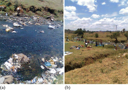
Eldoret Town, with more than 500,000 residents, is an industrial and agricultural town located in the Rift Valley, western part of Kenya. Despite its rapid growth in population and economic activities, the town has never been equipped with an organized ravage system, and consequently garbage and other refuse materials are mostly discarded outside of the town, without applying any specific managed strategy. Such an unsuitable procedure has inflicted substantial damage on the environment ().
Photo 1. (a) Pollution of river Sosiani through leaching and solid waste from the current disposal site. (b) Evident health risks to inhabitants living close to the current disposal site and using the waters of river Sosiani.
1.1. Landfill siting criteria and the potential application of GIS
A good waste disposal area has few characteristics. This area should be away from the regions in which there is a history of flooding. Otherwise, the wastes can be a serious source of water pollution thus ground-water table data should be used to avoid ground-water pollution. Another constraint for a proper waste disposal area is to have a specific distance from the faults in the region. The geological maps can be used for the purpose of identifying faults and locations where the structure of crust is weak. Land use maps, road maps, and other environmental factors should also be considered in locating a safe and environment-friendly waste disposal area (Akbari et al. Citation2008).
The GIS is widely used in landfill site selection to achieve the combination of the identified criteria to generate the suitability maps (Leao et al. Citation2004). Presently, it is the most reliable tool as it has the capability to store, retrieve, and analyze a large amount of data as well as outputs visualization (Kao and Lin Citation1996, Basagaoglu et al. Citation1997, Kao and Lin Citation1999, Kontos et al. Citation2003, Sener et al. Citation2006).
The rationale of the current study is that for spatial planning and decision-making, particularly in the finding of a precise dumping site, GIS should be linked to other advanced mathematical modeling capabilities such as the MCDA, to identify the single most preferred option from a set of potential options.
The methodology proposed in this article presents an integrated approach to construct a spatial decision support system for landfill siting via a two-stage analysis. To determine the suitable sites, the first-stage analyses use GIS digital map overlay techniques. In the second stage, MCDA is used to rank the proposed candidate sites for final selection (refer to Section 3.2 for the theoretical justification of the proposed approach).
The rest of the article is organized as follows: Section 2 concentrates on the study area and data, whereas Section 3 presents the proposed methodological framework and conceptualization. Sections 4 and 5 detail the data preparation and results, respectively. Finally, the study discussions and conclusions are, respectively, presented in Sections 6 and 7.
2. Study area and data
This section consists of a description of the study area and checking the nature of each data available and ways of analyzing all data based on the criteria which meet the requirements for landfill siting.
2.1. Geographical extent and background information about the study
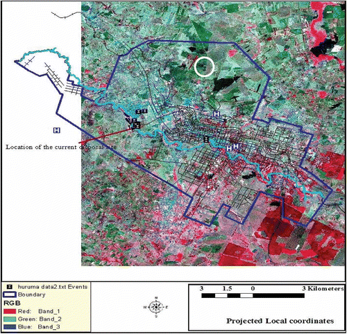
The study area () is EM, which is the headquarters of Uasin Gishu County. The municipality covers an area of approximately 78 km2, lies at an average altitude of 2085 m above sea level, and is estimated to be the fastest growing town in Kenya.
Figure 1. Color composite image of the study area (bands 2, 3, and 4 of ETM + sensor of Landsat data) dated 30 July 2001. The extent of the town is outlined and the current location of the disposal site is also shown in the western part of the town.
2.2. Data capture: sources and significance
There were generally four sources from which the data used in this study were obtained:
-
Spatial information and the satellite image of the town. The satellite image used was a 15 m pan-sharpened Landsat ETM + (). Most of the vector data layers used in this study were prepared through digitization of existing base maps, followed by geo-rectification using map-to-map registration. The vector maps were overlaid on the satellite images to verify the precision of the base map.
-
The spatial data that give the information about the location of different articles, for example, the current waste disposal site, schools, hospitals, airport locations were determined using the GPS device. Such spatial information were correlated and incorporated onto the vector map layer.
-
The third is the attribute information – quantitative and qualitative information about the spatial elements.
-
Other information elements were collected through interview and questionnaires administered to the relevant Eldoret Municipal Council (EMC) management experts including the town mayor; town clerk; ward representatives (councilors); the municipal council section heads of the following departments: Planning and Development, Engineering, Public Health, Legal Affairs, Finance, Transportation, Environment and Natural Resources Management, Water and Sewerage Services, Education Services, and Community and Social Services.
2.3. Data analyzed
As part of the data analyzed, the average sources and quantities of solid waste produced in EM in tons per month, in 2008, are presented in .
Table 1. Average quantities of solid waste produced within the Eldoret Municipality in 2008
From , about 400 tons/day of solid waste is produced and hardly a half of this amount is safely handled on a daily basis. The sources of wastes are also varied and therefore a suitable disposal site needs to be developed to have environmental safety criteria that present consciousness about the environment and public health.
GIS data sets of land use, rivers, wetlands, roads, demography, airports, digital elevation models (DEMs), and slope were collected for the Eldoret Municipal from: Ministry of Lands, Ministry of Transport, Department of Physical Planning, Ministry of Water, and the Department of Statistics ().
Table 2. GIS map layers used in the study
The criteria for data selection were based on constraints and factors for an ideal landfill siting (), with the broad criteria including the terrain parameters, natural resources, and human infrastructure.
Table 3. Characteristics of the data layers analyzed in the study
3. Methods
3.1. Conceptual framework: a methodological overview
Landfill siting is a complicated process requiring a detailed assessment over a vast area to identify suitable location for constructing a landfill subject to many different criteria. GIS offers the spatial analysis capabilities to quickly eliminate parcels of land unsuitable for landfill site (Chang et al. Citation2008). This study employed GIS to perform a screening process that led to identification of a potential suitable candidate sites based on site-specific criteria. The suitability criteria are defined with the focus to minimize any potential health risks from direct or indirect contamination due to the proximity of a landfill site with respect to key geographic features. Thus, the first-stage analysis using GIS is essential for the initial identification of a potentially suitable landfill sites prior to undertaking further analyses or field investigations. Although the initial screening is based on criteria related to environmental and ecological factors involved in the site-selection process, there are certain criteria such as impact on historical markers, public comfort, and economic factors for which data are not always readily available, which cannot be included in the first stage.
A second-stage analysis based on a handful of suitable sites from the initial GIS screening was performed with the objective of including the opinions of experts in the region through MCDA. MCDA is considered useful in addressing the issue of lack of availability of data for certain important criteria as well as to incorporate human judgment into the selection process that can prove useful in solving political debates. This approach captures the fuzzy nature of decision-making. The second stage of analysis using MCDA was applied to rank the proposed candidate sites and summarize the final selection. Such method followed in the process of identifying the most suitable landfill site.
Qualitative parameters can be used directly as linguistic variables or can be transformed into cardinal ones and then used as quantitative variables (Munda et al. Citation1994). The ranking of the options after aggregating and taking all information about the impacts of the options and the preferences of the decision-makers plus the concerned groups into account presents the result. It depends on the available data, the structure of the information, chosen aggregation method, and preferences.
In general, a MCDA consists of the following steps (Munda et al. Citation1994, Strassert Citation1995): (1) definition and structuring of the problem; (2) generation of options; (3) definition of a set of evaluation criteria; (4) choice between discrete and continuous methods; (5) preparation of the decision (supply of data); (6) identification of the preference system of the decision-maker and eventually affected groups of the society; and (7) choice of an aggregation procedure carrying out of the procedure; usage of feedback loops with the people affected by the decision.
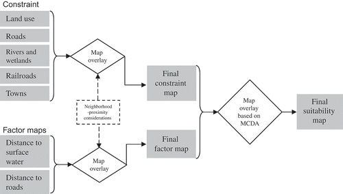
Following the above framework, the present investigation applied an integrated GIS-MCDA-based approach (), by aggregating all relevant layers to locate the proper waste disposal-dumping site and to reduce the search area over vast land coverage to leave only those areas that are suitable for siting a prospect landfill. The aggregation of the data layers is based on the neighborhood-proximity information around the determinant spatial elements.
Figure 2. Model applied for locating suitable land for solid waste landfill siting. The initial map overlay is based on the neighborhood-proximity analysis.
3.2. Brief theoretical exposition on MCDA and integration with GIS
MCDA for structuring decision problem and evaluating alternatives provides a rich collection of methods (Malczewski Citation2006). In most management and decision-making problems the management team has already a well-defined goal that must be achieved. To reach that aim, it is necessary to choose from a number of options. These options, in the field of the MCDA, are referred to as alternatives. However, the alternatives may not be obvious, as in the case of optimal landfill siting.
The decision-makers consider the existing alternatives that have different attributes and characteristics and the final task is to choose the best among them. Choosing among the alternatives is done by considering the impact of these alternatives on the quality of the final result alongside with shortcomings of every alternative. Therefore, effects of alternatives on different issues such as environmental issues, financial matters or cost–benefit considerations, social considerations, technical problems, etc., give rise to consideration of several criteria which play important roles in finalizing the project.
However, the criteria demonstrate the characteristics and important issues on which the final goal is evaluated. If a decision-maker wants to rank the importance of the alternatives, this only is according to the criteria. But it should be noticed that according to every different criteria, the ranking between the alternatives would be different.
For applying MCDA, a tool is needed which takes the ranking and comparison data to process them and calculates the weights of different alternatives or criteria. MCDA is based on a number of pivotal evaluation criteria, defined according to conditions of the case study that should be considered. Carver and Openshaw (Citation1992) stated four main benefits for using integrated MCDA and GIS:
-
the ability to perform the complex analysis of many different criteria;
-
the model uses factor weighting to integrate the analysis for value judgments;
-
it creates a systematic framework of analysis;
-
it has all of the advantages of the GIS database.
To combine MCDA and GIS, each of the criteria should be represented as a map in the GIS database (Malczewski Citation1999, Baban and Wan-Yusof Citation2003). It should be noticed that two types of criteria maps, factor maps and constraint maps, are not the same. A factor map represents the quality of achieving an objective through a spatial distribution (Malczewski Citation1999). However, a constraint map represents restrictions or limitations on decision-making problem that do not allow certain actions to be taken (Malczewski Citation1999).
The first requirement of nearly all discrete methods is a performance table containing the evaluations or criteria scores of a set of alternatives on the basis of a set of criteria. The alternatives are decision objects from which the decision-maker should choose one or several ones to implement. Let denote a set of n alternatives. The evaluation criteria are factors on which alternatives are evaluated and compared. Formally, a criterion is a function g, defined on A, taking its values in an ordered set, and representing the decision-maker's or expert's preferences according to some points of view. The evaluation of an alternative
according to criterion g is written as g(a), with
being a set of m evaluation criteria and
being the set of criteria indices.
The next step consists in the aggregation of the different criteria scores using a specific decision rule (or aggregation procedure) and taking into account the decision-maker's preferences, generally represented in terms of weights that are assigned to different criteria. The term ‘aggregation’ is used both in GIS and multi-criteria analysis (MCA) literatures. In GIS community, this term implies spatial aggregation (e.g., aggregating spatial units). It is a combination function that ‘aggregate’ different map layers. In MCA community, this term implies functional aggregation of partial evaluations of alternatives (using, for e.g., weighted sum technique) into a unique and global evaluation. The aggregation of criteria scores permits the decision-maker to make comparison between the different alternatives on the basis of these scores. Decision rules are somehow the identities of the multi-criteria methods.
How to combine the several criteria maps to form a single index of evaluation is the primary issue in the multi-criteria decision-making problem (Eastman Citation2003). As the solution lies in the intersection, logical AND, of the conditions; the constraint maps simply are multiplied together; that is, where
.
Mathematically, a criterion map is the set
, where
is a set of spatial mapping units and
is a mono-valued criterion function defined as follows (E is a measurement scale):
It is important to mention that multi-criteria analysis has been used, since its emergence, to spatial decision problems without the use of GIS. Nevertheless, multi-criteria analysis alone is not able to take into account explicitly the spatial dimension of spatial decision problems. Koo and O'Connell (Citation2006), for instance, remarks that with conventional spatial multi-criteria analysis (i.e., without the use of GIS), the performances of decision alternatives are either intrinsically a spatial or aggregated into a unique value. In other words, these approaches suppose that the study area is spatially homogeneous, which is unrealistic. Furthermore, most multi-criteria analysis softwares are of little utility in spatial decision-making as they lack functionalities required to: (1) collect, store, manage, and analyze spatial data, and (2) represent the spatial dimension of decision problems. These two problems are well handled by GIS. Thus, GIS and multi-criteria analysis are two complementary tools, each of which has advantages and some limitations in spatial decision-making; their integration permits us to avoid these limitations.
The uncertainty and the fuzziness generally associated with any decision situation require a sensitivity analysis enabling the decision-maker(s) to test the consistency of a given decision or its variation in response to any modification in the input data and/or in the decision-maker preferences.
The final recommendation in multi-criteria analysis may take different forms, according to the manner in which a problem is stated. Roy (Citation1996) identifies four types of results corresponding to four ways for stating a problem: (1) choice: selecting a restricted set of alternatives, (2) sorting: assigning alternatives to a set of pre-defined categories, (3) ranking: classifying alternatives from best to worst with eventually equal positions, and (4) description: describing the alternatives and their follow-up results. The currently available multi-criteria methods permit us to deal with the choice, sorting, and ranking cases only.
For continuous factor maps, a weighted linear combination (Eastman Citation2003) is used. In this method, the factor maps are multiplied by a certain weight which is assigned to each of them and then the summation of the resulted maps produce an overall suitability map. The result map is derived by multiplying the overall factor map and overall constraint map.
MCDA incorporates the expert knowledge of decision-makers in getting solutions that are spatially structured and fuzzy in nature, by inputting the preferences and intuitive judgments in the decision-making process.
3.3. Site-selection criteria: review and case study considerations
According to Chang et al. (Citation2008), a landfill site must be situated at a fair distance away from biophysical elements such as water, wetlands, critical habitats, and water wells to reduce the risk of contamination from landfill. Different studies used different buffer distances from streams and rivers based on the size of the watershed, such as buffer of 0.8 km (Siddiqui et al. Citation1996), 180 m (Zeiss and Lefsrud Citation1995), and 2–3 km (Kao and Lin Citation1999). Considering the size of municipality, the growth rate and consultations with the related departments, and expert-based variable buffer distances were determined as in .
Table 4. Site-selection criteria and the proposed variable buffer zones
gives a guideline for EMC, based on the expert opinions, in short- and long-term planning considerations. From related studies, it has been suggested that proximity of a landfill to a ground-water well is an important environmental criterion in the landfill site selection so that wells may be protected from the runoff and leaching of the landfill. In this study, a buffer distance of 300 m from the wells is suggested to prevent contamination from landfill due to leaching of pollutants. Due to the abundance of water within the EM, there are hardly any wells, as most of the inhabitants are served by piped water systems.
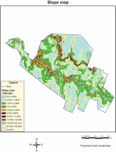
Slope is also an important factor when siting a landfill because higher slopes would increase runoff of pollutants from the landfill, and thereby increasing the contamination zone area (Kao and Lin Citation1999). Kao and Lin (Citation1999) suggested that a slope less than 12% would be suitable for the prevention of contaminant runoff. In this study, regions with slopes greater than 12% were defined as unsuitable for a landfill site. The slope information was obtained from DEM data sets of 30 m resolution obtained from digitizing topographical map and verified using GPS surveys.
Additionally, landfills should be situated at a significant distance away from urban residential areas due to public concerns, such as esthetics, odor (Tagaris et al. Citation2003), noise, influence on property value (Zeiss and Lefsrud Citation1995), and general health concerns (Nagar and Mizra Citation2002). Urban buffers may range from 150 m (Kao and Lin Citation1999) to 5 km (Zeiss and Lefsrud Citation1995). This range however is subjective to the specific case and the local authority regulatory guidelines.
Economic considerations include finding the most cost-effective route for transporting wastes and locating the most suitable land for the candidate sites based on land value (Siddiqui et al. Citation1996). Developments on or too close to existing road and rail networks would hinder public transportation and may have an impact on tourism in the region (Zeiss and Lefsrud Citation1995). Baban and Flannagan (Citation1998) used a 50 m buffer for roads, whereas Chang et al. (Citation2008) used a 300 m buffer.
The above-considered factors were re-grouped into three main components: (1) environmental and ecological impact); (2) transportation issues, and (3) economical impact. Any other factor was considered under Other Technical (OT) factors. OT factors included the economic criteria and public perception. The factors ecological impact, transportation issues, and economical impact fall within the broad criteria set in , namely: (1) terrain parameters, (2) natural resources, and (3) general social and technical infrastructure.
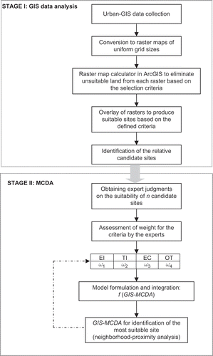
These factors were weighted by the experts following AHP according to Saaty (Citation1994, Citation2006). The weighting requires a MCDA, which is derived from a wide spectrum of facility management and based on expert judgment. MCDA can be represented, under normalized weighting conditions as: . That is, all the determinants should sum to unity within the decision system. The MCDA-GIS was integrated according to Chang et al. (Citation2008) ().
Figure 3. Flowchart of the methodology of the components of the integrated MCDA-GIS model for Eldoret Municipality (modified from Chang et al. Citation2008).
4. Thematic maps preparation and GIS analysis
The different constraint maps developed in this study included (1) environmental, (2) water body (river and wells), (3) slope, (4) urban, (5) transportation systems constraint, and (6) facilities map. The constraint maps, developed in GIS, were subject to advanced assessment in the second-stage analysis. The characteristics of the constraint map layers are discussed in the next sections.
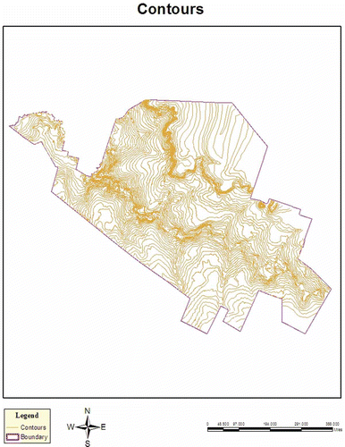
4.1. Contour map generation
The contour map layer was derived in ArcView by digitizing from the existing topographical map. The result of this analog to digital data conversion is presented in . From the digital contour map, the DEM, slope, and Triangular Irregular Networks (TIN) terrain characteristic can be defined. GPS surveys were used to verify on the accuracy of the digitized maps and to ensure accurate terrain TIN representations for flow analysis.
Figure 4. Digitized contour map of the study area.
4.2. Transportation system: road and railway network map
This comprised feature dataset displaying linear road network within the municipality. All the roads in the municipality were digitized from the topographic map as polylines and a shape file for roads was created. Typically, denser road networks are within the town center ().
Figure 5. Road and railway network within the Eldoret Municipality. The concentration of the road networks is an indicator of the urban population concentration and general land-use activities.
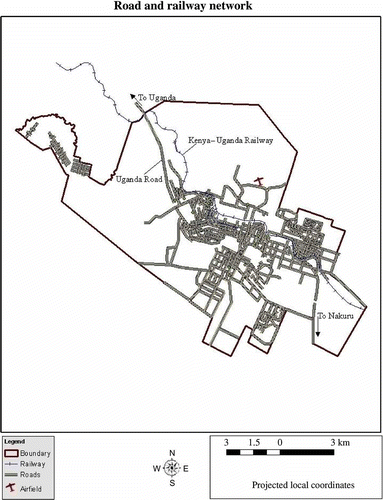
In , the transportation system within the study area consists of a main highway, single main rail system, main roads, secondary roads, and tracks. The concentration of the roads network depicts the concentration of human settlements outside the town center.
4.3. Land-use/land-cover information
The land-use and land-cover information within the study area comprised the urban and rural areas. Typically, the waste disposal areas should not be in the vicinity of the populated urban land used and rural settlement areas. For this purpose, a minimum buffer zone of 300 m around these areas was applied (). An indicator of land-use/land-cover information was defined from the satellite imagery () and the concentration or density of road networks.
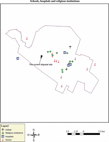
4.4. Other infrastructure information
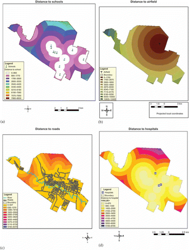
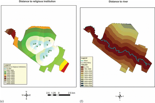
A layer comprising schools, hospitals, religious institutions, airstrip, and current disposal site was generated from the individual point feature maps using GPS. The results of the composite overlay are presented in . The results in show that schools, hospitals, and religious institutions are located within the vicinity of each other.
Figure 6. Schools, hospitals, and religious institutions and airfield represented as point data, from GPS field observations.
4.5. Elevation, slope, and water bodies map
A TIN for the area of study was created from the contours data, consisting of elevation attributes, and verified using GPS observations. This was converted to the DEM and the water body (river Sosiani) superimposed (). From the DEM, the slope map was derived (). The slope map is important in defining the direction of flows from a potential landfill site.
Figure 7. Elevation and surface water map of the study area.
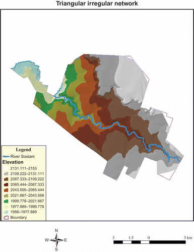
Figure 8. Slope map derived from the DEM map for topographical analysis.
5. Ranking and rating for each criterion and the governing algorithm
For each of the above layers, specific restrictions take the form of buffering at specified distances (S) surrounding (and, usually, including) the above areas. The initial ‘buffered’ layers (zones), containing the areas that are to be excluded from landfill siting, are then defined. The overlays (unions) between successive buffered layers are then performed, by each category individually and by all categories as a total, as follows:
where Li are the initial layers, Bi the buffered layers, Ui the successive unions between the buffered layers of each category, and Uti the total unions between the successive unions of each subcategory. This stage considers the neighborhood and proximity of the landfill siting to the existing urban land use and the envisaged urban zoning and expansion.
The above spatial analysis setup produces all the candidate landfill sites, as the remaining sites of the ‘exclusion process’. For each remained candidate site, all the characteristics concerning its relationship to the exclusion criteria may be given: distances, visibilities, volumes, etc., from layers Li .
After determining the unacceptable areas, the remaining areas are classified into classes of high and low priority for being used as waste disposal areas. This is done through two steps of weighting process. In the first step, each layer is internally weighted based on the minimum and maximum distances. In the second step, each layer is externally weighted based on how critical and important the data layer is to the waste disposal problem.
5.1. Internal weighting
In this part, each data layer is studied individually. The locations of each data layer can take a weight between zero and nine, based on their direct distance to the features, implementation as well as on expert judgment. As an example, considering the transportation networks, the locations that are close to the roads have a higher weight than the ones far away from the road network. Similarly, from the geological aspect, the locations are weighted based on whether the soils have a low penetration factor or are hard to dig or are close to clay area (which can be used to cover the surface wastes) or not. For the river, water wells, and fault layers, for example, the locations which are far from them have higher weight and vice versa. For urban and rural areas, the locations are weighted based on their distance to these centers. The distance should not be so far that the transportation becomes a problem and not so close that it provides an unpleasant appearance to the sight seeing, parks, and recreational facilities, which are mostly in the suburbs of cities. For agricultural and industrial centers, the highest weight is given to locations with a distance of 2–5 km. In respect of slope, the highest weight is given to the slopes between 0% and 2% and the lowest weight is given to the slopes over 20%. This is due to the fact that waste disposal trucks have difficulty moving on roads with slopes over 20%, and slopes greater than 20% results in rapid flows of water.
The internal weighting was carried out using the buffer zones generation through neighborhood-proximity analysis. The results of the different buffer zones are as follows ().
Figure 9. Buffer zones generated from internal weighting: (a) schools, (b) airfield, (c) roads, (d) hospitals, (e) religious institutions, and (f) river through neighborhood-proximity analysis.
Because of the different scales on which the criteria were measured, it was necessary that factors be standardized before combination. In this research, a linear scaling method is applied using the minimum and maximum values as scaling points for standardization (EquationEquation (1)1).
where Xi is the standardized value for ith criterion, Ri the raw score for the ith criterion, R min the minimum score for the ith criterion, and R max the maximum score for the ith criterion. An option is provided to standardize factors to a 0–255 byte scale, which can be rescaled between two classes: unsuitable (value 0) or most suitable (value 10).
Reclassification of datasets is required before the datasets can be combined, for data uniformity. The buffer zone datasets were reclassified to assign values of preference according to the criteria in question. The datasets were first set to a common scale. This is a scale that shows how suitable a particular location is. Therefore, each dataset was set to a common scale within the range of 1–10, assigning higher values to attributes within each dataset that are more suitable for locating a landfill site.
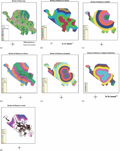
As the sanitary landfill should be located far away from human settlements and other land use such as schools, hospitals, and churches, the input datasets for the buffer layers were reclassified. The most suitable locations, which are of course the furthest from human inhabitance being given 10 and the least suitable were the closest places which were assigned a value of 1. The output is a reclassified distance map ().
Figure 10. Reclassified buffer distances corresponding to (a) slope, (b) schools, (c) airfield, (d) railway line, (e) hospitals, (f) religious institutions, and (g) roads.
5.2. External weighting
The primary issue in multi-criteria evaluation is how to combine the information from several criteria to form a single index of evaluation. A criterion is some basis for a decision that can be measured and evaluated.
In this study, two kinds of criteria were considered: factors and constraints. A factor is a criterion that enhances or detracts from the suitability of a specific alternative for the activity under consideration. A constraint serves to limit the alternatives under consideration and classifies the areas into two classes: unsuitable (value 0) or suitable (value 1).
In Section 5.1, the locations are weighted within each data layer internally. However, it is obvious that the data layers do not have equal weight for the problem in hand. Therefore, each data layer is weighted based on the technical, implementational, safety, environmental, economical, and other factors. shows the external weighting schema used in this study, which is based on the joint ideas of the focus expert groups as outlined in Section 2.2. These focus expert groups, comprising of the managers and technocrats, under the Local Government Act, are charged with the formulation and implementation of the broad Municipal Council's policies and economic development agenda.
Table 5. External weighting schema for the considered data layers. The weights are derived by computing the principal eigenvectors of the pairwise comparison matrix
The external weighting is implemented by: (1) performing pairwise comparisons, (2) assessing the consistency of the pairwise judgments, and (3) finally computing the relative weights, for each indicator (i.e., data layer component). The weights are derived by computing the principal eigenvectors of the pairwise comparison matrix.
Preference ranking organization method, based on building ‘fuzzy’ dominance relations through the use of preference functions was adopted to determine the weightage of the expert decisions. The difference between the levels of criterion achievement of two alternatives is compared. If the values do not differ for a particular criterion, no preference is indicated. This MCDA is considered to take care of the drawbacks of the AHP, which is mainly used in crisp decision applications. The MCDA takes into account the uncertainty associated with the mapping and depicting of people's judgment to an evaluation scale that is weighted and linearly combined.
With a weighted linear combination, factors are combined by applying a weight to each followed by a summation of the results to yield a suitability map (EquationEquation (2)2):
where S is the suitability factor, wi the weight of factor i, and xi the criterion score of factor i.
In the presented method that Boolean constraints also apply, the procedure can be modified by multiplying the suitability calculated from the factors by the product of the constraints (EquationEquation (3)3).
where Cj is the criterion score of constraint j and Π the product.
The result of this multi-criteria evaluation will be a final aggregated suitability image. In the aggregated suitability image, zones whose area is smaller than 20 hectares are eliminated from the allocation process. The next step then determines the land suitability of a zone by calculating the average of the suitability of the cells belonging to a zone using the zonal land suitability index (EquationEquation (4)
4).
where: is the zonal land suitability,
the local suitability of the cells i belonging to the zone z, and
the number of cells of zones z.
The results from the land suitability are the potential sites for landfill sites with varying land suitability indices. The zone indices are then ranked for evaluation. The evaluation criteria used in the present study are those indicated in .
The results in show that external weightings in landfill siting are highly influenced by proximities to transportation networks, surface water bodies, and urban settlements, each with a weight of 0.25. These in turn influence the slope factor which is ranked fourth with a weight of 0.10. The slope weight ensures siting and further site management over long temporal and varied climatic conditions. Hospitals, schools, and religious institutions, which are mostly located within the same vicinity and near primary and secondary schools, exhibit the same least weight of 0.05 each. This follows from the locations and weightings of the considered determinants.
The external weighting results are presented in . The results in show that the current solid waste disposal site (), which was chosen randomly based only on the fact that the site was a decommissioned quarry mine, lies in a highly unsuitable zone.
Figure 11. Classified maps derived showing two scenarios of solid waste suitability site locations for Eldoret Municipality: (a) using uniform weights and (b) using variable weights as in .
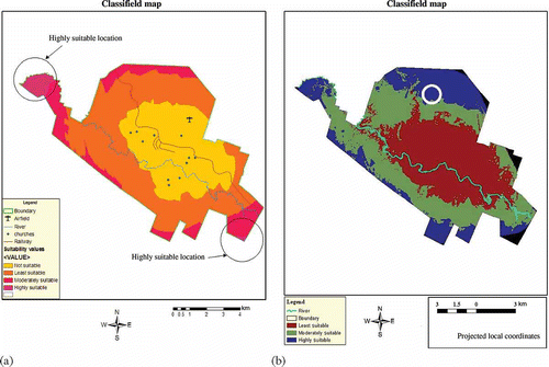
The result in shows that the most suitable site is located in the northern part of the Central Business District. A physical evaluation of this site reveals its suitability in size and slope, being away from the surface water systems, and not far off when considering transportation or haulage costs and yet far enough from the human settlement and activities.
6. Discussions
In most developing towns, less attention has been paid toward the utility of expert-based multi-decision analysis for optimal waste disposal siting. This study reveals that implementing broad-based expert knowledge is essential in the management of waste disposal in short- and long-term considerations.
In this study, the following key determinants were considered in the site-selection process: (1) available land – in terms of size and land filling life span; (2) haul distance – to cater for operating costs; (3) topographical aspects – to guide in natural flows; (4) surface water hydrology – in considering drainage and surface water pollution; (5) local environmental conditions – odor, vector (health) considerations; and (6) general urban land use. The results in proved that although all the above six factors are important, their relative contributions, expressed as weights, greatly influence the location of the solid waste disposal site.
Preference ranking organization method, based on building fuzzy-dominance relations through the use of preference functions was adopted to determine the weight of the expert decision. The difference between the levels of criterion achievement of two alternatives was compared, and it was found that if the values do not differ for a particular criterion, no preference is indicated. From the results of this comparative analysis, negative and positive probability matrices were developed.
From the results in , equal weighting resulted in locations that were not viable mostly due to haulage distance (being too far) and topographical disadvantages, that is, near surface water and being steep. The site alternative in presents the most optimal location for a growing urban scenario. The most suitable solid waste disposal site is indicated as the white circle within the highly suitable area in the northeastern part of the municipality.
The current approach can be advantageous in solving controversial municipal planning debates in the future. Further, the advantage of the proposed approach is placed upon the capability to incorporate the knowledge of the domain evaluation process in the uncertain decision-making process when there is a lack of crisp information related to certain criteria.
Nevertheless, the drawback of this method is that the selection of the best candidate site is dependent on the judgments of the experts and can be sensitive to changes in the decision weights associated with criteria. In certain situations, two experts may have highly contradicting judgments about suitability of a candidate site. Hence, it is required to assess the extent of difference or similarity between the experts in association with decision weights. Where the experts are forced to give ranks to the pre-defined candidate sites, the selections are only made among these. But some might argue that it may not be the very best and ideal case. If the screening process is loosened a little bit, then may be a candidate site can be selected, and may be on some criterion, it will score higher. To respond to this challenge, a field check was done in the early stage and in the middle of this study to ensure that the most suitable site would be the approved one at the field eventually.
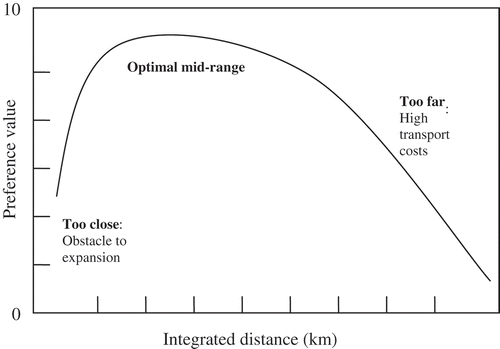
For future considerations in terms of expansion of the proposed landfill site, decision-maker set preferences can be used, as conceptualized in , where the distance from generation points are integrated with expansion parameters to determine the preference values—such that too close integrated distances are considered obstacles to expansions whereas too far distances constitute high transportation costs, and the best options are those in the mid-ranges.
Figure 12. Future expansions of decision-maker set preferences: a theoretical perspective.
7. Conclusions
Landfill-based disposal option is the most widely used in many countries. An open approach, considering engineering, social, economic, and political factors, should be adopted in the facility siting. An important element of the landfill siting process is a technique for evaluating the basic suitability of all available land for sanitary landfill as an aid in selection of a limited number of sites for more detailed evaluation. The technique should establish criteria to illustrate the relative suitability of land for sanitary land filling. In addition, the technique should be practical, taking into account the broad-based expertise opinions.
This study presented a MCDA-GIS integrated approach to overcome the drawbacks of the crisp AHP. From the results of the MCDA-GIS integrated approach presented in , it is evident that the current disposal site () falls in the critically unreliable zone. The optimal location should therefore be 4.8 km northeast of the current site. This site lies on a fairly flat open area and distant from the surface water and human settlement. Further, there is already an access road to this proposed site. The proposed siting is in view of the fact that Eldoret is a growing municipality with increasing industrial and commercial activities.
The findings of the research are significant as the approach used can be generalized and applied to the socioeconomic and natural characteristics of the region. Consequently, a spatial decision support system may strengthen the generation and evaluation of alternatives by providing an insight of the problem among the varied objectives and granting support to the process of decision-making under uncertainty. In response to the vague or fuzzy conditions in decision-making toward site selection, domain experts, in the second stage, can be used.
Future developments of the proposed model may include sensitivity analysis to detect the effect of buffer distance changes on the total remaining area and the inclusion of dynamic spatial layers. It is however advisable that before resorting to the landfill option, towns and cities should consider waste minimization through recycling and reuse, and waste transformation alternatives.
Related Research Data
References
- Akash , B.A. , Mamlook , R. and Mohsen , M.S. 1999 . Multi-criteria selection of electric power plants using analytical hierarchy process . Electric Power Systems Research , 52 ( 1 ) : 29 – 35 .
- Akbari , V. 2008 . Landfill site selection by combining GIS and fuzzy multicriteria decision analysis. Case study: Bandar Abbas, Iran . World Applied Sciences Journal , 3 ( Suppl. 1 ) : 39 – 47 .
- Allanach , W.C. 1992 . Regional landfill planning and siting . Public Works , 123 : 48 – 50 .
- Anderson , R.F. and Greenberg , M.R. 1982 . Hazardous waste facility siting: a role for planners . Journal of the American Planning Association , 48 ( 2 ) : 204 – 218 .
- Awomeso , J.A. 2010 . Waste disposal and pollution management in urban areas: a workable remedy for the environment in developing countries . American Journal of Environmental Sciences , 6 ( 1 ) : 26 – 32 .
- Baban , S.M.J. and Flannagan , J. 1998 . Developing and implementing GIS assisted constraints criteria for planning landfill sites in the UK . Planning Practice and Research , 13 ( 2 ) : 139 – 151 .
- Baban , S.J. and Wan-Yusof , K. 2003 . Modelling optimum sites for locating reservoirs in tropical environments . Water Resources Management , 17 ( 1 ) : 1 – 17 .
- Basagaoglu , H. 1997 . Selection of waste disposal sites using GIS . Journal of the American Water Resources Association , 33 ( 2 ) : 455 – 464 .
- Brocherhoff , M.P. 2000 . An urbanizing world . Population Bulletin , 55 ( 3 ) : 3 – 44 .
- Carver , S. and Openshaw , S. 1992 . “ A geographic information systems approach to locating nuclear waste disposal sites. In ” . In Waste location: spatial aspects of waste management, hazards and disposal , Edited by: Clark , M. , Smith , D. and Blowers , A. 105 – 127 . London : Routledge .
- Chan , F.T.S. , Chan , M.H. and Tang , N.K.H. 2000 . Evaluation methodologies for technology selection . Journal of Materials Processing Technology , 107 ( 1–3 ) : 330 – 337 .
- Chang , N.B. , Parvathinathan , G. and Breeden , J.B. 2008 . Combining GIS with fuzzy multicriteria decision-making for landfill siting in a fast-growing urban region . Journal of Environmental Management , 87 ( 1 ) : 139 – 153 .
- Chen , S.M. 1996 . Evaluating weapon systems using fuzzy arithmetic operations . Fuzzy Sets and Systems , 77 ( 3 ) : 265 – 276 .
- Cheng , C.H. 1997 . Evaluating naval tactical systems by fuzzy AHP based on the grade value of membership function . European Journal of Operational Research , 96 ( 2 ) : 343 – 350 .
- Eastman, J.R., 2003. IDRISI Kilimanjaro Guide to GIS and Image Processing, Idrisi Source Code.
- Fanti , M.P. 1998 . Genetic multi-criteria approach to flexible line scheduling . International Journal of Approximate Reasoning , 19 ( 1–2 ) : 5 – 21 .
- Hauser , D. and Tadikamalla , P. 1996 . The analytic hierarchy process in an uncertain environment: a simulation approach . European Journal of Operational Research , 91 ( 1 ) : 27 – 37 .
- Jensen , J.R. and Christensen , E.J. 1986 . Solid and hazardous waste disposal site selection using digital geographic information system techniques . The Science of the Total Environment , 56 : 265 – 276 .
- Kao , J.J. and Lin , H.Y. 1996 . Multifactor spatial analysis for landfill siting . Journal of Environmental Engineering , 122 ( 10 ) : 902 – 908 .
- Kao , J.J. and Lin , H.Y. 1999 . Enhanced spatial model for landfill siting analysis . Journal of Environmental Engineering , 125 ( 9 ) : 845 – 851 .
- Kao , J. , Lin , H. and Chen , W. 1997 . Network geographic information system for landfill siting . Waste Management and Research , 15 ( 3 ) : 239 – 253 .
- Karadimas , N.V. and Loumos , V.G. 2008 . GIS-based modelling for the estimation of municipal solid waste generation and collection . Waste Management Research , 26 ( 4 ) : 337 – 346 .
- Kohbanani , H.R. 2009 . Site selection for dumping urban waste using MCDA methods and GIS techniques . World Applied Sciences Journal , 7 ( 5 ) : 625 – 631 .
- Kontos , T.D. , Komilis , D.P. and Halvadakis , C.P. 2003 . Siting MSW landfills on Lesvos Island with a GIS-based methodology . Journal of Waste Management , 21 ( 3 ) : 262 – 277 .
- Koo , B.K. and O'Connell , P.E. 2006 . An integrated modelling and multicriteria analysis approach to managing nitrate diffuse pollution: 1. Framework and methodology . International Journal of Science of the Total Environment , 359 ( 1–3 ) : 1 – 16 .
- Labib , A.W. , O'Connor , R.F. and Williams , G.B. 1998 . Effective maintenance system using the analytic hierarchy process . Integrated Manufacturing Systems , 9 ( 2 ) : 87 – 98 .
- Leao , S. , Bishop , I. and Evans , D. 2004 . Spatial temporal model for demand and allocation of waste landfills in growing urban regions . Journal of Computers, Environment, and Urban Systems , 28 ( 4 ) : 353 – 385 .
- Malczewski , J. 1999 . GIS and multi-criteria decision analysis , New York : Wiley .
- Malczewski , J. 2006 . GIS-based multicriteria decision analysis: a survey of the literature . International Journal of Geographical Information Science , 20 ( 7 ) : 703 – 726 .
- McHarg , I.L. 1969 . Design with nature , New York : Doubleday .
- Munda , G. , Nijkamp , P. and Rietveld , P. 1994 . “ Multicriteria Evaluation in environmental mangement: why and how? ” . In Applying Multiple Criteria Aid for Decision to Environmental Management , Edited by: Paruccini , M. 1 – 22 . Dordrecht : Kluwer Academic Publishers .
- Nagar , B.B. and Mizra , U.K. 2002 . Hydro-geological environmental assessment of sanitary landfill project at Jammu City, India . Green Journal , 17 ( 8 ) : 223 – 245 .
- O'Leary , P.R. , Canter , L. and Robinson , W.D. 1986 . “ Land disposal ” . In The solid waste handbook: a practical guide , Edited by: Robinson , W.D. 259 – 335 . New York : Wiley .
- Roy , B. 1996 . Multicriteria methodology for decision aiding , Dordrecht : Kluwer Academic Publishers .
- Saaty , T.L. 1994 . Fundamentals of decision making and priority theory with the analytic hierarchy process , Pittsburgh : RWS Publications .
- Saaty , T.L. 2006 . Rank from comparisons and from ratings in the analytic hierarchy/network processes . European Journal of Operational Research , 168 ( 2 ) : 557 – 570 .
- Sener , B. , Suzen , L. and Doyuran , V. 2006 . Landfill site selection by using geographic information systems . Environmental Geology , 49 ( 3 ) : 376 – 388 .
- Siddiqui , M.Z. , Everett , J.W. and Vieux , B.E. 1996 . Landfill siting using geographical information systems: a demonstration . Journal of Environmental Engineering , 122 ( 6 ) : 515 – 523 .
- Strassert , G. 1995 . Das Abwägungs problem bei multikriteriellen Entscheidungen , Frankfurt : Peter Lang .
- Tagaris , E. 2003 . A methodology to estimate odors around landfill sites: the use of methane as an odor index and its utility in landfill siting . Journal of the Air and Waste Management Association , 53 ( 5 ) : 629 – 634 .
- Zeiss , C. and Lefsrud , L. 1995 . Analytical framework for facility waste siting . Journal of Urban Planning and Development , 121 ( 4 ) : 115 – 145 .