Abstract
The NOAA Coral Reef Watch (CRW) program uses near-real-time satellite measurements of sea surface temperature (SST) to monitor thermal stress of the coral reefs. These data provide up-to-date measurements pinpointing areas that are currently at risk for thermally induced coral bleaching. All of CRW's products can be accessed through CRW's Web portal at http://coralreefwatch.noaa.gov. Ongoing examination of tropical SSTs reveal regionally diverse but changing SST patterns and trends. In 2005 and 2010, two record-breaking thermal stress events occurred throughout much of the eastern Caribbean (Wilkinson and Souter Citation2008. Status of Caribbean coral reefs after bleaching and hurricanes in 2005. Townsville, Australia: Global Coral Reef Monitoring Network, and Reef and Rainforest Research Centre, 152; Eakin et al. Citation2010. Caribbean corals in crisis: record thermal stress, bleaching, and mortality in 2005. PLoS One, 5, e13969). In 1998 and 2010, record-breaking bleaching occurred in all tropical oceans (Wilkinson Citation2000. Status of coral reefs of the world 2000, Townsville, Australia: Australian Institute of Marine Science, 375). With global satellite SSTs spanning more than two decades, we now have sufficient data to examine global- and basin-scale trends. The development and production of these CRW products takes place within National Oceanic and Atmospheric Administration's National Environmental Satellite, Data, and Information Service (NESDIS). This NESDIS team is comprised of scientists from the Marine Ecosystem & Climate Branch in the Satellite Oceanography & Climatology Division of the Center for Satellite Applications & Research and from personnel within NESDIS' Office of Satellite Products and Operations.
Introduction
The United States' National Oceanic and Atmospheric Administration (NOAA) began producing sea surface temperatures (SSTs) from satellite data in 1972. Since that time, monitoring SST from earth-orbiting infrared radiometers has had a wide impact on oceanographic science and marine ecosystem management. One of the principal sources of satellite infrared data for SST measurement is the Advanced Very High Resolution Radiometer (AVHRR), which has been carried on NOAA's Polar Orbiting Environmental Satellites since 1978. Typically two of these satellites provide data operationally at a time. AVHRR is a broad-band, four- or five-channel (depending on the model) scanner, sensing in the visible, near-infrared, and thermal infrared portions of the electromagneticspectrum (http://www.nesdis.noaa.gov/SatProducts.html). The Polar Orbiting Environmental Satellites system offers the advantage of daily global coverage from each satellite, by making near-polar orbits roughly 14 times every 24 hours. In situ SSTs from buoys (drifting and moored) are used operationally to maintain satellite-derived SST accuracy by removing biases and compiling statistics with time (McClain et al. Citation1985, Strong Citation1991, Strong et al. Citation2000).
The NOAA Coral Reef Watch (CRW) program uses near-real-time satellite measurements of SST to monitor thermal stress of the coral reefs. These data provide up-to-date measurements pinpointing areas that are currently at risk for thermally induced coral bleaching. All of CRW's products can be accessed through CRW's Web portal at http://coralreefwatch.noaa.gov.
Ongoing examination of tropical SSTs reveal regionally diverse but changing SST patterns and trends. In 2005 and 2010, two record-breaking thermal stress events occurred throughout much of the eastern Caribbean (Wilkinson and Souter Citation2008, Eakin et al. Citation2010). In 1998 and 2010, record-breaking bleaching occurred in all tropical oceans (Wilkinson Citation2000). With global satellite SSTs spanning more than two decades, we now have sufficient data to examine global- and basin-scale trends.
The development and production of these CRW products takes place within NOAA's National Environmental Satellite, Data, and Information Service (NESDIS). This NESDIS team is comprised of scientists from the Marine Ecosystem & Climate Branch in the Satellite Oceanography & Climatology Division of the Center for Satellite Applications & Research and from personnel within NESDIS' Office of Satellite Products and Operations.
Sea surface temperature data
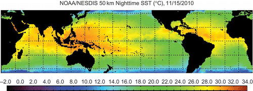
The CRW's composite AVHRR-SST products have a gridded spatial resolution of 0.5° [50 km] and are updated twice weekly in near real time. On Mondays, the past week's Thursday–Sunday's data are used, and on Thursdays, Monday–Wednesday's data are used. Nighttime-only observations are used in CRW SST products to minimize errors due to the diurnal temperature variation that would occur if both day and night observations were used. Many of NOAA's other operational SST products are produced by blending day and night observations; however, in the tropics, nighttime SST products have been demonstrated to compare more favorably with in situ buoy SSTs at 1 m depths (Montgomery and Strong Citation1995). An example of CRW's global nighttime composite AVHRR-SST product can be seen in . (Colour figures are avaliable online.)
Figure 1. CRW nighttime sea surface temperature chart.
The NOAA/NESDIS nighttime AVHRR-SST products were developed primarily for CRW's monitoring and assessment of thermally induced coral bleaching. CRW's satellite SST-based coral bleaching monitoring and assessment products include SST anomalies, Coral Bleaching HotSpots, Degree Heating Weeks, Bleaching Alert Areas, Coral Bleaching Satellite Virtual Stations, and automated Satellite Bleaching Alerts for Virtual Stations. These products are provided free of charge to users in various formats, including text and Hierarchical Data Format data files, images, animations, Google Earth, and online GIS.
CRW SST anomaly product
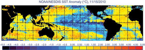
A simple SST anomaly (SSTA) was one of the first CRW products. Near-real-time satellite data were compared against a climatology built from nighttime AVHRR data from 1985 to 1993 (excluding 1991 and 1992 due to volcanic aerosol in the stratosphere from the Mt. Pinatubo eruption in 1991). Twelve monthly climatologies were derived as means of weekly mean nighttime SSTs from the 7 years and then interpolated back into daily mean climatologies. The actual daily SSTA was derived as the difference between daily satellite data and daily climatologies. The SSTA has found wide-ranging uses and often has been the preferred product for the NESDIS' National Climate Data Center (NCDC) when observing the onset and effects of El Niño and La Niña (http://www.ncdc.noaa.gov/oa/climate/elnino/elnino.html). The SSTA product was inaugurated experimentally in 1997 and became officially operational in 2002 (see for an example of the SSTA).
Figure 2. CRW sea surface temperature anomaly (SSTA) chart. in °C.
CRW bleaching HotSpot product
Because mass coral bleaching can result from anomalously high temperatures, NESDIS began developing coral-specific satellite global 50 km resolution experimental products early in 1997 (initially the SST Bleaching HotSpots followed by degree heating week (DHW) products). These were developed as indices of thermal stress that causes coral bleaching and were based on earlier work by Jokiel and Coles (Citation1990), Lesser et al. (Citation1990), Glynn and D'Croz (Citation1990), Montgomery and Strong (Citation1994), Gleeson and Strong (Citation1995), Berkelmans and Willis (Citation1999), and Reaser et al. (Citation2000). In 2002, the ‘HotSpot’ product became officially operational (see for an example of the HotSpot product).
Figure 3. CRW bleaching HotSpot chart. Index values in °C.
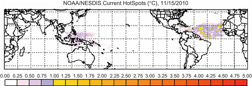
The coral bleaching HotSpot is not a typical climatological SST anomaly. It is a positive-only anomaly that measures the occurrence of the thermal stress caused by anomalously high water temperatures for a region. As corals live without bleaching under the average warm-season conditions that they experience each year, HotSpots are based on temperatures warmer than the normally experienced high temperatures. As such, it is an anomaly based not on the average of all SSTs from all seasons but on the climatological mean temperature of the climatologically hottest month (i.e., the maximum of the monthly mean (MMM) SST climatology). This unique climatology, derived from nighttime AVHRR-SSTs for the 7 years of the 9-year period from 1985 to 1993 (see above), is static in time but varies in space (pixel dependent) (Winter Citation1995, Strong et al. Citation1997). Since the HotSpot is an anomaly based on the MMM SST experienced by corals at that location, it is an assessment of instantaneous thermal stress. All negative values are set to 0 to indicate the corals are experiencing no thermal stress from high SST.
CRW bleaching degree heating weeks product
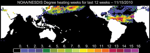
The CRW HotSpot product provides a measure of the instantaneous intensity of the thermal stress. However, it is the cumulative effects of that stress on a biological system such as a coral reef that drive physiological response. A thermal stress index, called a degree heating week (DHW), was developed to monitor this cumulative effect. DHW represents the accumulation of HotSpots for a given location (pixel), over a rolling 12-week time period. Preliminary indications from comparisons of in situ observations of coral bleaching with the HotSpot product showed that a HotSpot value of less than 1° is insufficient to cause visible stress on corals. Consequently, only HotSpot values ≥1°C are accumulated (e.g., four consecutive weekly HotSpot values of 1.0, 2.0, 0.8, and 1.2°C produce a DHW value of 4.2 degree-weeks – the week at 0.8 is excluded as 0.8 is less than 1). One DHW is equivalent to 1 week at a HotSpot of 1°C or 1.5 weeks of HotSpot levels at 2°C, and so forth. For an example of the DHW product, see .
Figure 4. CRW degree heating weeks chart. Values in deg-weeks.
Field observations have consistently indicated that the highest correlation with bleached corals is found when DHW values of 4 have been reached. By the time DHW values reach 8, widespread bleaching is likely and some mortality can be expected, based on these same observations. CRW has applied these DHW values for nearly 10 years when generating satellite bleaching warnings and alerts and found them to be an accurate, although frequently conservative, predictor of bleaching and mortality (Liu et al. Citation2003, Eakin et al. Citation2010).
These products have been successful in monitoring several major coral bleaching episodes around the globe (e.g., Goreau and Hayes Citation1994, Wellington et al. Citation2001, Eakin et al. Citation2010). HotSpot and DHW charts are produced by CRW twice weekly in near real time from composite nighttime AVHRR-SST products. These products, along with descriptions of the methodologies, are Web accessible at http://coralreefwatch.noaa.gov/satellite/product_overview.html.
Since 2000, when the DHW product was inaugurated as an experimental product, CRW has successfully issued bleaching warnings for mass bleaching events both on regional and global scales. These warnings helped to organize timely, effective, and efficient in situ monitoring and assessment of mass coral bleaching. The following mass bleaching events are among the most notable: 2000 at Easter Island, 2001 in the Ryukyu Islands, 2002 in the Great Barrier Reef, 2002 in the Northwestern Hawaiian Islands, 2003 at Bermuda, 2004 at Kiribati, 2005 in the greater Caribbean, 2010 in the Indian Ocean and Southeast Asia, and 2010 in the Caribbean. Many of these were record-breaking events regionally. Field reports on the status of the corals continue to be received and, on virtually every occasion, bleaching has been confirmed. Not as a comprehensive test of the DHW product, these examples indicate that the DHW is providing a sound and conservative near-real-time assessment of coral bleaching thermal stress and potential bleaching severity. Some evaluations (e.g., van Hooidonk and Huber Citation2009) have validated CRW's products and indicated the potential for improvement.
CRW bleaching alerts area product
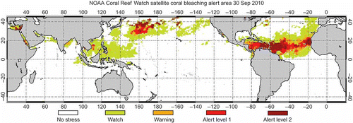
To assist managers and nonphysical scientists with the use of the CRW's product suite a Bleaching Alert Area product was developed (http://coralreefwatch.noaa.gov/satellite/baa/index.html) to provide summarized information on the occurrence, strength, and spatial distribution of bleaching thermal stress. Based on the values of both the HotSpot and DHW products, bleaching thermal stress is categorized into five tiers: No Stress, Bleaching Watch, Bleaching Warning, Bleaching Alert Level 1 and 2 (see the table below).
The HotSpot value is examined first to see if bleaching thermal stress is currently present. At a site, if no current stress is present, even if thermal stress had been built up in the immediate past with accumulated DHW, the thermal level is categorized as No Stress. The highest levels, Alert Levels 1 and 2 correspond to DHW ≥ 4 and ≥8, the levels at which mass coral bleaching and mortality are expected, respectively. shows an example of the Bleaching Alert Area product.
Figure 5. CRW coral bleaching alert area product.
CRW' satellite virtual stations
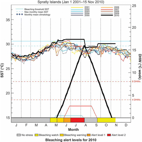
CRW has identified nearly 225 virtual stations throughout the tropics to provide site-based information requested by reef managers (http://coralreefwatch.noaa.gov/satellite/current/products_vs.html). These provide reef managers and scientists with quick access to SST, DHW, and alert-level time series that reveal ongoing strength of thermal stress at these coastal locations around the globe.
One figure showing data from the Spratly Islands Virtual Station in the South China Sea is provided as an example in . This view provides its 10-year summary of SSTs and DHW from 2001 to 2010. The most recent data from 2010 (through 15 November 2010) are shown in bold black line. The major bleaching event for the present year was easily identifiable as the warmest of the decade for almost every month. Some lengthy periods of ‘flat-lining’ beginning in June represent periods when cloud cover made satellite SST measurement unavailable and were likely due to the extensive 2010 monsoons. If accurate, the DHW peak of nearly 15 would be clearly at an historic level for this site in South China Sea, easily exceeding those DHW levels seen in 2007. A more likely result was that this site was not adequately observed through the lengthy period of cloud cover and quite likely should have measured DHWs somewhere between 5 and 10 – still a significant event for the Spratlys. In the future, CRW hopes to include cloud-penetrating microwave SST data in its analysis to help overcome this present shortcoming.
Figure 6. SST and DHW time series graph at Spratly Islands Virtual Station. SST is shown in the center of graphs and read using the vertical axis on the left. DHW is shown in the bottom portion of the graphs and read using the vertical axis on the right. SST and DHW time series for the current year are plotted in thick black solid line. Previous year SSTs, back to 2001, are color coded (see online version) as shown at the top of the graph. When the DHW value is 0, no DHW time series is plotted. The coral bleaching thermal stress level (or alert level) of the present year is color coded (see color legend at bottom of graph) and plotted beneath along the horizontal axis. Three types of information describing the long-term mean conditions about the virtual station site are also provided on the graph (light blue): the monthly mean climatology ( + ), the maximum monthly mean (dashed horizontal line), and the bleaching threshold SST (solid horizontal line).
CRW automated Satellite Bleaching Alert system
The implementation of the CRW automated satellite bleaching alert system for virtual stations in 2005 made the delivery of up-to-date bleaching thermal stress information to CRW users more efficient. Bleaching thermal stress level, categorized in the five tiers (described earlier), is checked for changes at all the virtual stations at each twice-weekly monitoring update. Interested users may sign up for free e-mail alerts of bleaching conditions at any (or all) of the CRW virtual stations. These are delivered twice weekly to subscribers' e-mail addresses when an alert level is reached and resemble the format of a hurricane/typhoon watch/warning. Subscribers are informed via automated e-mail of increases and decreases in thermal stress level, if any, at their reefs. Anyone may subscribe to these alerts online at CRW's Virtual Station Website http://coralreefwatch.noaa.gov/satellite/virtual_stations/index.html or can send an e-mail request to [email protected].
CRW Google Earth product
All CRW operational (and some experimental) products are also provided in format useable in Google Earth. The CRW Google Earth product suite can be accessed from the CRW home Webpage or directly at http://coralreefwatch.noaa.gov/satellite/ge/index.html.
CRW in action: Caribbean 2005 and 2010 and Indo-Pacific 1998 and 2010
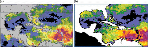
During the past 25 years, the most notable and intense mass coral bleaching in the western hemisphere are the 2005 and 2010 Caribbean events shown in (Eakin et al. Citation2010).
Figure 7. CRW's Caribbean Sea DHWs for October in (a) 2005 and (b) 2010 – for scale see
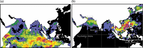
Also significant in its wide-reaching effects was the first globally distributed bleaching that began early in 1998 in the southern Indian Ocean and continued into late 1998 in the northern hemispheric tropical oceans – particularly the western Pacific. DHW values through May 1998 can be seen in a. In 2010, significant bleaching has occurred in all of the world's tropical oceans for only the second time. This significant bleaching touched most reefs in the northern Indian Ocean and was peaking around Southeast Asia and the South China Sea by August 2010 (b).
Figure 8. Indian Ocean and Southeast Asian DHWs for (a) May 1998 and (b) August 2010 – for scale see .
Changing global SSTs
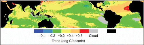
Using reanalyzed SST data from NOAA/NASA Version 5.0 Pathfinder monthly mean SSTs at 4 km resolution (Casey and Cornillon Citation1999, Kilpatrick et al. Citation2001), CRW has calculated SST trends for the 25-year time frame 1985–2009 (). Areas of gray indicate pixels where the availability of SST data is insufficient to calculate a reliable trend due to persistent cloud cover in the 25-year dataset. These are found principally off western South America, the coastal regions surrounding Indonesia and Papua New Guinea, as well as a small portion of the eastern South Atlantic off Africa. Areas shown in green demonstrated weak cooling or warming (–0.2 to + 0.2°C/decade) for the period while those areas depicted as more orange or red demonstrated much higher increases in SST. In the 25-year period, the entire tropical region demonstrated either warming or neutral conditions (–0.2 to + 0.2°C/decade) – except for the small ‘blue’ (<–0.2°C/decade) cooling region off Mexico (west of Baja California) in the northeastern tropical Pacific Ocean.
Figure 9. Twenty-five-year satellite SST trends (1985–2009).
provides a global summary of SST trends during the past 25 years over the tropical–subtropical oceans from 35°N to 35°S and over the northern (N) and southern (S) tropical–subtropical oceans. Trends for the complete, northern, and southern hemispheres with the corresponding standard errors of the trends are 0.17 (0.04), 0.20 (0.04), and 0.14 (0.04)°C/decade, respectively. Following a peak in 2003, and a subsequent 5 years of cooling, temperatures again began to rise in 2009.
Figure 10. Tropical [35°N – 35°S] yearly SST means with trends: global tropics and by hemisphere.
![Figure 10. Tropical [35°N – 35°S] yearly SST means with trends: global tropics and by hemisphere.](/cms/asset/a27e7286-d3ab-4bae-a048-ef4319170ccd/tagi_a_576266_o_f0010g.jpg)
Greater hemispherical differences can be seen over the Indian Ocean (). The northern hemisphere includes the Red and Arabian seas and may have seen greater continental influence as compared with the more truly ‘oceanic’ southern Indian Ocean.
Figure 11. Indian Ocean trends.
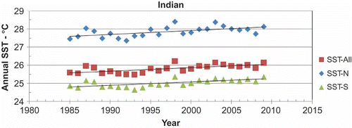
Indian Ocean SST trends for the complete, northern, and southern hemispheres with their corresponding standard errors of the trends are 0.19 (0.05), 0.21 (0.06), and 0.18 (0.04), respectively (all in °C/decade).
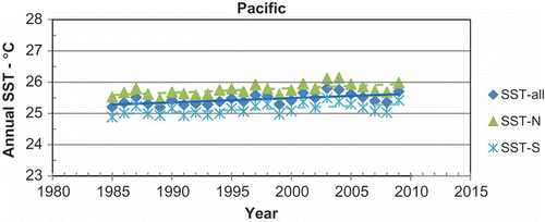
Over the Pacific Ocean, trends are a bit smaller overall but show very little difference from north to south (). Pacific Ocean trends for the complete, northern, and southern hemispheres with their corresponding standard errors of the trends (smallest of all basins) are 0.14 (0.04), 0.15 (0.04), and 0.13 (0.04)°C/decade, respectively.
Figure 12. Pacific Ocean trends.
Sandwiched between two continents, the Atlantic Ocean experienced some of the highest 25-year SST trends among the ocean basins observed in our study (, see for spatial patterns).
Figure 13. Atlantic Ocean trends.
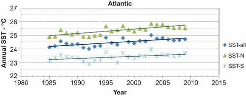
Atlantic Ocean trends for the complete, northern (twice that of the southern), and southern hemispheres with their corresponding standard errors of the trends are 0.25 (0.05), 0.32 (0.06), and 0.16 (0.06)°C/decade, respectively.
Additional experimental CRW products
a. Enhanced 50 km product suite
The 50 km gridded land mask presently used in CRW's operational 50 km product suite excludes satellite SST data from near the coast where most coral reefs exist. This means that the current operational products only directly monitor 40% of the world's coral reefs. For the other 60% of the reefs, thermal stress values are obtained from offshore waters adjacent to coral reef areas. During most mass coral bleaching events, temperature anomalies usually occur in phase or nearly in phase over a broad area that includes both the reefs and adjacent open ocean waters. This allows the current operational 50 km products to work well in detecting mass coral bleaching caused by large-scale thermal stresses. However, coastal water temperatures over reefs are often different to those seen in adjacent offshore pixels and usually have greater spatial and temporal variability. As a result, CRW's current operational products may inaccurately represent coastal thermal stress or miss small-scale features found right over the reefs that are masked out by the operational land mask. To improve CRW's ‘direct’ monitoring for these masked coastal reefs, a new 50 km land mask was developed, along with a new set of climatologies for these new partially land-filled ocean pixels, to produce CRW's new suite of experimental enhanced 50 km near-real-time satellite global coral bleaching monitoring products. The new climatology is also based on 1985–2006 data from the Pathfinder dataset and resolved several errors identified in the operational climatology. This product suite is available online at http://coralreefwatch.noaa.gov/satellite/e50/index.html.
b. Seasonal coral bleaching thermal stress outlook
This new product has been developed by NOAA to provide a predictive bleaching outlook ranging from 1 week to 4 months into the future. CRW and the Physical Sciences Division of NOAA's Earth System Research Laboratory have teamed up in this effort inaugurated on 1 July 2008 (Liu et al. Citation2008); an improved version (version 2) was launched on 10 August 2010. The SSTs used for the derivation of the outlook product are based on a statistical tropical ocean prediction model covering the tropical strip between 30°S and 30°N (linear inverse model, Penland and Matrosova Citation1998). The prediction is currently available at 2 × 2 degree spatial resolution and weekly temporal resolution and set up for predicting bleaching thermal stress with ‘lead times’ of 1–16 weeks. The outlook system comprises three integrated parts: prediction of weekly SST, prediction of weekly bleaching thermal stress potential, and seasonal outlook of potential coral bleaching thermal stress. See this product at http://coralreefwatch.noaa.gov/satellite/bleachingoutlook/index.html.
Some other experimental products currently under production, development, and/or evaluation are listed below:
-
c. Disease outbreak risk
-
d. Light stress damage
-
e. Short-term SST trends
-
f. Ocean acidification
-
g. Surface wind doldrums
-
h. Bleaching stress return period and duration.
The detail and methodologies of these products can be accessed at CRW's ‘Experimental Products’ Website page: http://coralreefwatch.noaa.gov/satellite/current/experimental_products.html.
The future of CRW products
There are a number of improvements that will be seen in CRW products in the near future and a number of directions that CRW would like to take. In the near term, CRW intends to include as many of the relevant satellite-based environmental measurements as possible. These include, but are not restricted to, wind, water transparency, light, waves, and so on. Other non-satellite data that support the existing and proposed space-borne measurements would also be incorporated and could include tides, currents, bathymetry, and so on. CRW is also working to improve its SST-based products through increased spatial resolution and inclusion of additional satellite data, including geostationary satellites and microwave sensors. CRW is also working with collaborators on ways of improving its coral bleaching seasonal outlook products. Another collaboration is in the area of climate change where CRW is using now-casting knowledge and 25 + years of satellite data to help understand the outputs from global climate models and their relationship to coral bleaching thermal stress as the planet's climate continues to change. This should assist in the understanding and prediction of long-term climate impacts on coral reef ecosystems globally.
Acknowledgments
The contents in this manuscript are solely the opinions of the authors and do not constitute a statement of policy, decision, or position on behalf of NOAA or the US Government.
Related Research Data
References
- Berkelmans , R. and Willis , B.L. 1999 . Seasonal and local spatial patterns in the upper thermal limits of corals on the inshore Central Great Barrier Reef . Coral Reefs , 18 : 219 – 228 .
- Casey , K.S. and Cornillon , P.A. 1999 . Comparison of satellite and in situ based sea surface temperature climatologies . Journal of Climate , 12 : 1848 – 1863 .
- Eakin , M. 2010 . Caribbean corals in crisis: record thermal stress, bleaching, and mortality in 2005 . PLoS One , 5 : e13969
- Gleeson , M.W. and Strong , A.E. 1995 . Applying MCSST to coral reef bleaching . Advances in Space Research , 16 ( 10 ) : 151 – 154 .
- Glynn , P.W. and D'Croz , L.D. 1990 . Experimental evidence for high temperature stress as the cause of El Niño-coincident coral mortality . Coral Reefs , 8 : 181 – 191 .
- Goreau , T.J. and Hayes , R.L. 1994 . Coral bleaching and ocean “hot spots” . Ambio , 23 : 176 – 180 .
- Jokiel , P.L. and Coles , S.L. 1990 . Response of Hawaiian and other Indo-Pacific reef corals to elevated temperature . Coral Reefs , 8 : 155 – 162 .
- Kilpatrick , K.A. , Podesta , G.P. and Evans , R. 2001 . Overview of the NOAA/NASA advanced very high resolution radiometer pathfinder algorithm for sea surface temperature and associated matchup database . Journal of Geophysical Research , 106 : 9179 – 9197 .
- Lesser , M.P. 1990 . Bleaching in coral reef anthozoans: effects of irradiance, ultraviolet radiation, and temperature on the activities of protective enzymes against active oxygen . Coral Reefs , 8 : 225 – 232 .
- Liu , G. , Skirving , W. and Strong , A.E. 2003 . Remote sensing of sea surface temperatures during the 2002 (Great) barrier reef coral bleaching event . EOS, Transactions, American Geophysical Union , 84 ( 15 ) : 137 – 141 .
- Liu , G. NOAA coral reef watch coral bleaching outlook system . Proceedings of the 11th international coral reef symposium . 2008 . July . pp. 951 – 955 . Ft. Lauderdale, Florida
- McClain , E.P. , Pichel , W.G. and Walton , C.C. 1985 . Comparative performance of AVHRR-based multi channel sea surface temperatures . Journal of Geophysical Research , 90 : 11587
- Montgomery , R.S. and Strong , A.E. 1994 . Coral bleaching threatens oceans, life . EOS, Transactions, American Geophysical Union , 75 : 145 – 147 .
- Penland , C. and Matrosova , L. 1998 . Prediction of tropical Atlantic sea surface temperatures using linear inverse modeling . Journal of Climate , 11 : 483 – 496 .
- Reaser , J.K. , Pomerance , R. and Thomas , P.O. 2000 . Coral bleaching and global climate change: scientific findings and policy recommendations . Conservation Biology , 14 : 1500 – 1511 .
- Strong , A.E. 1991 . “ Sea surface temperature signals from space ” . In Encyclopedia of earth system science , Edited by: Nierenberg , W.A. Vol. 4 , 69 – 80 . San Diego, CA : Academic Press .
- Strong , A.E. , Kearns , E. and Gjovig , K.K. 2000 . Sea surface temperature signals from satellites – an update . Geophysical Research Letters , 27 ( 11 ) : 1667 – 1670 .
- Strong , A.E. Improved satellite techniques for monitoring coral reef bleaching . Proceedings of the 8th international coral reef symposium . Panama City, Panama. pp. 1495 – 1498 .
- van Hooidonk , R. and Huber , M. 2009 . Quantifying the quality of coral bleaching predictions . Coral Reefs , 28 : 579 – 587 .
- Wellington , G.M. , Strong , A.E. and Merlen , G. 2001 . Sea surface temperature variation in the Galapagos Archipelago: a comparison between AVHRR nighttime satellite data and in-situ instrumentation (1982–1988) . Bulletin of Marine Research , 69 ( 1 ) : 27 – 42 .
- Wilkinson , C. , ed. 2000 . Status of coral reefs of the world 2000 , 375 Townsville, , Australia : Australian Institute of Marine Science .
- Wilkinson , C. and Souter , D. , eds. 2008 . Status of Caribbean coral reefs after bleaching and hurricanes in 2005 , 152 Townsville, , Australia : Global Coral Reef Monitoring Network, and Reef and Rainforest Research Centre .
- Winter , T.M. The development of an operational global ocean climatology through the use of remotely sensed sea surface temperature . Trident scholar project report No. 235 . 1995 . U.S. Annapolis, MD: Naval Academy, 67