Abstract
In recent years, sea-level rise has been paid more and more attention. What causes the sea-level rise or fall is a key issue of attention. The factors affecting sea-level change are so complex that we still not completely understand its processing so well. Sea-level change would lead to not only shoreline retreats and submerged lands, but also the enhancement of marine motivation and the unstability of currently coastal sustainability. In this article, we present the analysis of the causes and possible trends of sea-level rise or fall, and the discussion of potential impacts of sea-level change on Hong Kong's coastal environment as a case study.
1. Introduction
Sea level refers to the level of the surface of the ocean. Mean sea level is the average between high tides and low tides. It is used as a datum for measuring the height of features on land or depth in the ocean, and it is also the baseline for plotting the global hypsometric curve (Müller et al. Citation2008). Atmospheric pressure readings are usually expressed as sea-level equivalents in order to eliminate the effects of altitude (Arendt et al. Citation2002). The sea level changes with different temporal and spatial scale (Douglas Citation1997, Citation2001). So the sea level can be observed with the use of tide gauge, satellite radar altimeter, natural markers, such as fossil shells and notches, and so on.
Due to global warming and the impact of human activities, the average of global sea levels rose by about 10–25 cm in the past century (Douglas Citation1997). However, in the twenty-first century, the value of global sea-level rise might be several times of the past century (Woodworth Citation2006, EPA Citation2008). An authoritative assessment report from Intergovernmental Panel on Climate Change (IPCC) believes that the future rate of sea-level rise will be about 3–10 mm per year (IPCC Citation1990). Until 2050, the best estimate of the value of sea-level rise is about 22 cm, and by 2100, the value rises up to 39 cm (IPCC Citation2007). The accelerated rise of sea level would submerge more areas and the extent of coastal erosion could be further worsening, since coastal erosion is often considered as a sign of sea-level changes or both of sea-level rise and sea-level fall (Morner Citation2010). In view of the seriousness of this global-scale environmental issue, more and more scientists are concerned with this critical problem.
The IPCC Third Assessment Report Working Group II (TAR WG II) reported that current and future climate change would be expected to have a number of impacts, particularly on coastal systems (IPCC Citation2001). Such impacts mainly include increased coastal erosion, more extensive coastal inundation, increased loss of property and coastal habitats, higher storm-surge flooding, inhibition of primary production processes, changes in surface water quality and groundwater characteristics, increased flooding risk and potential loss of life, loss of nonmonetary cultural resources and values, impacts on agriculture and aquaculture through declining soil and water quality, loss of tourism, and so on (http://www.evergladeshub.com/clim.htm).
In this article, we present the investigation of dominant factors leading to sea-level change, the analysis of the causes and trends of sea-level change, and the discussion of its potential impacts of sea-level change on coastal environment in Hong Kong as a case study.
2. The factors affecting sea-level changes
At a short temporal scale, sea-level change results from waves, tides, storm surge, and so on. In terms of a long temporal scale, however, factors leading to sea-level change mainly include water temperature, salinity, terrestrial water, geophysical processes, which belong to season to 10-year period impact factors. Accumulation of long-term factors induces short-term events (World Bank Citation2003).
2.1. Seawater temperature
Global warming is thought to result in the rise of water temperatures (IPCC Citation2007). Warming ocean causes the water to expand. Thermal expansion of seawater is one of the main factors (Lombard et al. Citation2005) affecting sea-level rise. As the specific volume of ocean thermal differences can be integrated according to following formula (Gill Citation1982), the global data of sea-level rise caused by thermal expansion can be expressed as
However, the thermal expansion of the global sea-level changes is not consistent; with long time scales and large spatial scales, differences are larger (Church Citation2001). For example, the Indian Ocean began to heat up since the 1960s, but obvious temperature rise at the Atlantic has occurred after the 1990s, and there is no reasonable explanation for these differences so far.
There are many researches on thermal expansion of sea water. The rate of thermal expansion of the global oceans during the last 50 years is estimated between 0.3 and 0.7 mm/a (Cazenave and Nerem Citation2004). Levitus et al. (Citation2005) gave a new result calculated from thermal expansion of sea water by using marine historical observations data, by which sea-level rise was at 0.5 ± 0.4 mm/a. In comparison, Cabanes et al. (Citation2001) suggested the rate of sea-level rise as about 3.1 ± 0.4 mm/a from 1993 to 1998 due to thermal expansion. shows some examples of thermal expansion contribution to sea-level rise. It is clear that these results are different from each other because of the different geo-locations in their study areas, methodologies, data sources, and so on. But the trend of sea-level rise is very similar. This reveals that global warming results in gradual increase of seawater temperatures, and then the anomaly of ocean temperatures gives rise to thermal expansion of seawater which is thought to be one of the major causes of sea-level rise.
Table 1. Some examples of thermal-expansion contribution to sea-level rise
2.2. Terrestrial water
Terrestrial water and sea water are important components of global water budget. Terrestrial water which mainly includes mountain glaciers and polar ice caps has also a great influence on sea-level rise (http://en.wikipedia.org/wiki/Current_sea_level_rise).
Since the twentieth century, mountain glaciers have been retreating because of global warming; especially in the last 10 years, the speed of retreat has quickened. Dyurgerov (Citation2002) studied about 260 glaciers in northern hemisphere over the past 40 years and concluded that global sea-level rise induced by the melting glaciers could be at about 0.27 mm/a by calculation and analysis of mass balance of projected glacier. However, this number is less than its real value because Allah Apsley, Patagonia, and Central Asia were neglected in the calculation. Arendt et al. (Citation2002) found in the twenty-first century that the ice in Alaska accelerated their melting speed, with the net mass loss of 96 ± 35 km3/a, which can lead to about 0.27 ± 0.19 mm/a sea-level rise. It is almost two times more than in Greenland ice. Rignot et al. (Citation2003) estimated the Patagonian ice fields, with the sea-level rise of 0.10 ± 0.01 mm/a due to the melting of ice sheets from 1995 to 2000. If taking into account the comprehensive utilization of the data in their previous results (Arendt et al. Citation2002, Dyurgerov Citation2002, Rignot et al. Citation2003), the mountain-glaciers melting could be with the sea-level rise at 0.64 ± 0.20 mm/a approximately. Thus, the impact of mountain glaciers on sea-level rise is considered as the second reason, right after the thermal expansion of seawater.
In addition to mountain glaciers, retreat of polar ice caps also results in sea-level rise. Antarctic ice sheet and Greenland ice sheet imply 99% of freshwater resources on the Earth. Sea level would have raised 70 m if all of them had melted. Even a small part of the melt will give rise to a huge impact on global sea level. Because the Greenland and the Antarctic continents are different in sea and terrain distribution characteristic, the feature of melting ice sheets is slightly different with each other. The melting of ice cap on the Antarctic continent is mainly caused by the melting of the base of ice shelf and icebergs going out of orbit. But mass loss of the Greenland ice sheets is mainly caused by the surface melting of the ice sheet and disintegration of icebergs.
Observations in coastal areas of Greenland ice sheet especially along the glacier mouth to the sea show that the channel region is thinning, and losses of the ice volume are about 51 km3/a which can lead to sea-level rise of 0.13 mm/a (Krabill et al. Citation2000).
Antarctic geographical range is more complex because of huge terrain area, high latitude, and harsh climatic conditions. Rignot and Thomas (Citation2002) made an estimation of the mass balance on 33 Antarctic glaciers, including 25–30 large glaciers, and obtained material losses in the West Antarctic of about 48 ± 14 km3/a, and the net material increase in the East Antarctic of 29 ± 23 km3/a. Accordingly, changes in sea level are 0.16 ± 0.05 mm/a and 0.06 ± 0.06 mm/a, respectively.
However, Zwally et al. (Citation2005) reported that Greenland ice sheet (from 1992 to 2002) was thinning at the margins with a small overall sea-level rise of about −0.03 mm/a, while the ice sheets in West Antarctica and East Antarctica showed a combined change of sea-level rise of + 0.08 mm/a during the same period. The contribution of these three ice sheets to sea level is at about 0.05 ± 0.03 mm/a, which is relatively smaller than most of previous studies (e.g., Miller and Douglas Citation2004). Thinning at the margins of the Greenland ice sheet and growth at higher elevations are an expected response to increasing temperatures and precipitation in a warming climate (Davis et al. Citation2005, Vaughan Citation2005, Zwally et al. Citation2005).
Briefly, the glacier contribution is estimated to have been 0.3 ± 0.1 mm/a over the twentieth century (IPCC Citation2001). The glacier contribution has not been measured directly, but was inferred from a combination of modeling studies and mass-balance observations during the past few decades. In comparison, the contribution of 20 glaciers to sea-level rise is estimated as 0.50 ± 0.18 mm/a for the period 1961–2003 and 0.77 ± 0.22 mm/a for the period 1993–2003 (IPCC Citation2007). This is largely based on compilation of mass-balance data (Dyurgerov and Meier Citation2005, Kaser et al. Citation2006).
2.3. Salinity
Changes of ocean salinity have also a great influence on sea water density and sea level at local scales, but its impact at the global scale is very weak. Recently, it is pointed out that the sea-level rise is about 0.05 mm/a due to the changes of salinity over the past 50 years, which is much less than the impact of thermal expansion and terrestrial water. As the changes of ocean salinity can reflect the amount of fresh water flowing into the ocean, a relationship model of salinity changes and the volume of fresh water into the sea can be established. The relationship model (Antonov et al. Citation2002) indicated that ocean desalination process for the period of 1957–1994 and sea level rise are equivalent to a mean value of 1.35 ± 0.50 mm/a.
2.4. Human activities
Human activities are another major cause of sea-level change. This is because human activities most likely lead to global warming (IPCC Citation2007) and changes of the cycles of land water, such as groundwater exploitation, urbanization, burning of fossil and biodegradable, deforestation, drainage of wetlands, reservoir factors, and irrigation.
Gornitz et al. (Citation1997) estimated the ranges in sea-level changes related to some major human transformations of the land hydrologic system. The increased runoff from the mining of groundwater and impermeable urbanization are potential critical human activities affecting sea levels. In comparison, runoff from the tropic deforestation and water released by burning of fossil fuel and vegetation, including wetlands clearance, provide a smaller share of the total. Taking them together into account, these processes could raise the sea level by 0.60–1.00 mm/a. However, water storage by dams and water loss by infiltration in reservoirs and irrigated fields with the evaporation from these surfaces could prevent the equivalent of 1.50–1.80 mm/a from reaching the sea. The final balance of these all human effects is to withhold the equivalent of 0.80 ± 0.40 mm/a from the sea. Therefore, the total comprehensive impact of human behavior on sea-level change is between −1.20 and −0.49 mm/a.
2.5. Geophysical processes
Since Earth has a changeable surface sphere, planet shape change of ice and non-glacial age could cause sea-level rise and fall (Lambeck Citation2004). In the past 20 years, the post-glacial rebound model of the land is gradually improving (e.g., Peltier and Fairbanks Citation2006, Argus and Peltier Citation2010). These models describe the earth shape changes, ocean geometric conditions and volume changes, and ice cap changes in Ice Age and Interglacial Age. Currently value of impact of earth surface rebound factors on the sea level is about 0.3 mm/a. Similarly, Plag (Citation2006) stated that the contribution of post-glacial rebound to global sea-level rise is likely to be at least 0.20 ± 0.04 mm/a.
2.6. Application of satellite data
Leuliette et al. (Citation2004) estimated sea-level rise by using satellite altimetry data at about 3.1 ± 0.4 mm/yr for 1993–2003. This value exceeds those from tide gauges. It is still unclear whether this represents an increase over the last decades; variability; true differences between satellites and tide gauges; or possibly systematic errors due to satellite calibration (IPCC Citation2001). A precision of about 20 mm for the current altitude of a satellite to measure sea levels (e.g., Cheney Citation1995) is primarily complicated by orbital decay and the difference between the assumed orbit and the earth geo-id (http://ibis.grdl.noaa.gov/SAT/pubs/papers/2001_Cheney_Encycl.pdf). This problem is partially corrected by regular re-calibration of satellite altimeters from land stations whose height from MSL is known by surveying. Over water, the height is calibrated from tide gauge data which are needed to correct for tides and atmospheric effects on sea levels.
Satellite altimeters have been widely used to measure global sea levels. The spatial coverage and accuracy of these satellite altimeters have been excellent, but the short length of the record (only since the latter half of the twentieth century) makes it difficult to determine any pattern in sea-level changes. More details can also be found on topics such as ‘Sea Level - river, oceans, effects, temperature, important, salt, effect, human’ at the website of http://www.waterencyclopedia.com/Re-St/Sea-Level.html#ixzz115tqHh8G.
3. Potential impacts of sea-level change on Hong Kong's coastal areas
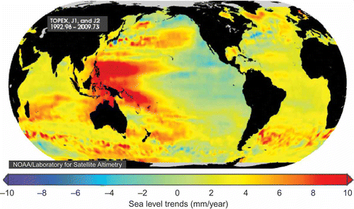
In the fourth assessment report of the IPCC, the rate of global mean sea-level rise was assessed as 1.8 ± 0.5 mm/a for the period 1961–2003 (IPCC Citation2007). The height of sea surface in western Pacific is higher than that in eastern Pacific due to interaction of trade winds and ocean currents. Likewise, sea water temperature is also higher in western Pacific than in eastern Pacific. These kind of anomalies of sea surface height and sea temperature make some countries in west coast of Pacific sensitive to sea-level rise. In South China Sea the rate of sea-level rise is 4.3 mm/a from 1992 to 2009 (adopted from NOAA, see ), and it is higher than the world average at 1–1.5 mm/a. However, Cheng and Qi (Citation2007) reported that the rise of sea level in South China Sea is 11.3 mm/yr from 1993 to 2000, but fall is 11.8 mm/yr from 2001 to 2005.
Figure 1. Trends of sea-level changes from 1992 to 2009. Courtesy of the Hong Kong Observatory of HKSAR.
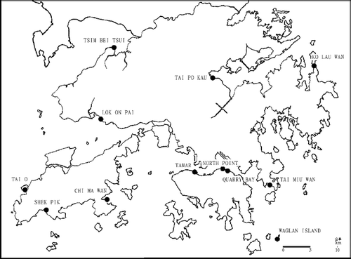
Hong Kong is located in the north of the South China Sea and the southern coast of China mainland, which is more sensitive to sea-level changes because of its special geo-location. The eastern side of Hong Kong is open to influences of the coastal cold current that carries colder water from the East China Sea along the Taiwan Strait to the southern China coast in winter, and the Kuro Shio current that transports warm water from the Pacific across the Luzon Strait into the South China Sea in spring time. During summer months, the Hainan current that carries warm water up to the northeastern coast of the South China Sea prevails. The western part of Hong Kong waters is estuarine while the eastern part is predominantly oceanic; between the two is a region of mixing (Hong Kong Geological Survey Citation2000). Since the 1950s, the Hong Kong Observatory has operated a number of automatic tide gauge stations within the territory of Hong Kong. shows the locations of these tide gauge stations.
Figure 2. Locations of tide gauge stations in Hong Kong.Source: Adopted from Hong Kong Observatory at http://203.129.68.24/publica/reprint/r556.pdf. Used with permission.
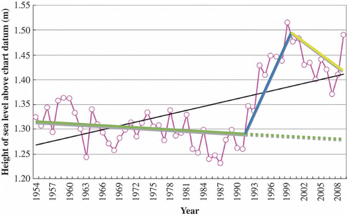
Hourly tidal records are available from the North Point tide gauge station for the period 1954–1985. This station was subsequently relocated to Quarry Bay, which is about 500 m east of the original station at North Point and has been put into operation since the beginning of 1986. Ip and Wai compared the tidal records at North Point and Quarry Bay and found no noticeable difference (Ip and Wai Citation1990). Hence, the tide gauge data from these two stations are regarded as belonging to the same series. The North Point/Quarry Bay tide gauge station provides the longest tidal records in Hong Kong. Wong et al. (Citation2003) reported that the general sea-level fall was 2 mm/yr during the period of 1954–1987, sea-level rise was 22.1 mm/yr from 1987 to 1999, and sea-level fall was 21 mm/yr from 1999 to 2003. In comparison, Ding et al. (Citation2001) reported that the sea-level rise in Hong Kong from 1954 to 1999 was 1.9 ± 0.4 mm/yr.
Figure 3 shows the annual mean height of sea level above the chart datum at North Point/Quarry Bay of Hong Kong from 1954 to 2009 (Lee et al. Citation2010). The 56 years of tide gauge records in the Victoria Harbour of Hong Kong demonstrate an unambiguous rise of the mean sea level during this period, in which there is a rapid rise of the sea level from 1993 to 1999 and a moderate decline from 2000 to 2008, which is similar with the results of 2001–2005 (Cheng and Qi Citation2007). The trend is similar to that observed by satellite remote sensing over the South China Sea since the early 1990s (Cheng and Qi Citation2007) and also tide gauge records at other coastal stations in Hong Kong. On average, the mean sea level in the Victoria Harbour has risen at a rate of 2.6 mm/a during the period 1954–2009 (Lee et al. Citation2010). This is similar to the rate of sea level rise of 2.7 mm/a in the South China Sea in the past 30 years as reported by State Oceanic Administration of China, but slightly higher than the global mean sea-level rise of 1.8 mm/a from 1961 to 2003. However, it is also noted that the sea-level change-trend in during the period of 1954–1992 (solid green line) is falling about 2.1 mm/yr, which is very close to the result from Wong et al. (Citation2003). This trend pattern is quite different from the change-trend of sea level in 1993–2000 (solid blue line) and that in 2001–2009 (solid yellow line) in . The detail of these change-trends of sea levels from 1963 to 2010 is being investigated and will be forthcoming in the near future.
Figure 3. Annual mean sea-level at North Point/Quarry Bay (1954–2008).Source: Adopted from Hong Kong Observatory at http://crc.edb.gov.hk/crchrome/en/download/cf1012/EDB_10_4_16.pdf. Used with permission.
Sea-level rise or fall has great influence on Hong Kong's coastal region (see ). The potential impacts can be mainly summarized as the following key points:
| 1. | Some inter-tidal zone and low-lying land will be submerged due to sea-level rise. As we realized, the risk and impact is related to the height above sea level. From it is clearly noted that the elevations in the Pearl River Delta (PRD) region of South China are very close to the sea level. As a result, some coastal areas will become uninhabitable because of coastal erosion of sea water with the continuous rising of sea levels. Hong Kong is vulnerable due to its proximity to the coastal sea with the large population along the coast. The increased sea level would affect the traditional production and life style, such as fish ponds and lower residential areas (e.g., Tai O). It would also impact the low-lying areas, where the slope is very gentle with poor drainage systems such as in Sheung Wan and Tai O (Hong Kong Observatory Citation2009). Figure 4. Sea-level risks of Southeast Asia. Courtesy of the Hong Kong Observatory of HKSAR. 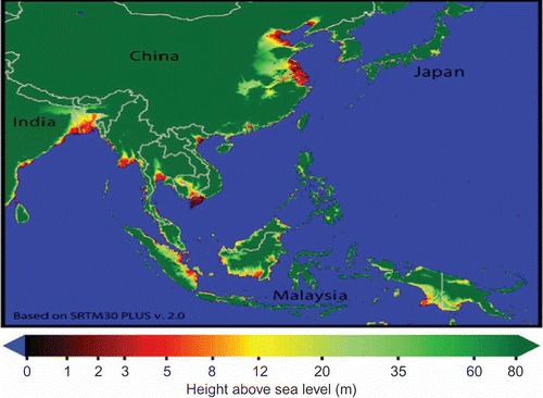 | ||||
| 2. | Intensive storm surge is leading to more seriously extreme natural disasters such as flooding and mud-slides. Sea-level rise could give rise to the maximum dynamic change of tidal features, resulting in the enhancement of storm tides and the increase of frequency of storm surges. In the extreme condition, the rise in sea levels due to typhoon can be more than 3 m above the tide level (Hong Kong Observatory Citation2009, Lee et al. Citation2010). The increased sea level pushes storm surge much higher with more coastal erosion. This in turn could lower the flood capacity of rivers such as Shan Pui River. | ||||
| 3. | Sea-level rise would result in the loss of wetland areas in northwest of New Territories in Hong Kong. Wetland is one of the most important ecosystems, which has been paid more attention in recent years. The increased sea level invades a large amount of wetlands and would make extinct a lot of rare species. Moreover, changes in salinity will affect the vegetation and habitat of migrating birds. Additionally, the wetland and beach further retreat due to more soil erosion at the same time. | ||||
| 4. | Salinity increases and fresh water supply reduces. Sea-level rise would intensify the scale of saline water intrusion. First, freshwater resources are very scarce in Hong Kong. Intrusion of saline water has to reduce the amount of drinkable and irrigable water. Second, freshwater cannot bring enough nutrients to the estuary, which would impair the healthy growth of the coastal marine ecosystem, and therefore the balance of the food chain might be broken. Finally, the intrusion of saline water makes the current water quality worse, and therefore intensifies land salinization. | ||||
4. Conclusion
On the basis of tide gauges and decade satellite observations, research achievements, and the analysis of factors effecting on sea-level changes, sea-level changes can be summarized as the following key points:
| 1. | Thermal expansion is the dominant factor that arouses sea-level rise, by approximately 2.6 160:112 0.4 mm/a. The second impact factor is the mountain glaciers, with the value of 0.66 mm/a. This value might be smaller than reality because of the restrictions of observing region. The contribution can also be from ice sheets. For example, Greenland is 0.13 mm/a and Antarctic is -0.14 to 0.4 mm/a. In comparison, direct effect from human activity is about 0.35 mm/a. During the last 10 years, various comprehensive factors make the sea level rise up to about 2.5–3.84 mm/a. | ||||
| 2. | After the 1990s, the trend of sea-level rise is accelerating. The largest increase of sea-level rise is in the Northwest Pacific and East Indian Sea, which is 10 times more than the global average. | ||||
| 3. | Sea-level change is obviously relative to the seasonal variation. Especially, in September northern hemisphere sea level achieves the highest value, while the lowest value happens in March. Meanwhile, southern hemisphere is contrary. Sea-level seasonal variation also has a regional difference. In general, the northern hemisphere's seasonal variation is higher than the southern hemisphere's. Moreover, the seasonal variation in Pacific and Atlantic Ocean is larger than the other oceans. | ||||
In conclusion, the rate of sea-level change is under a lot of uncertainty, but most current research suggests that sea level would be rising with more rapid and nonlinear instead of linear trends. Sea-level changes would also impact all species and severely change their way of life. For a typical coastal city such as Hong Kong, it would also result in a huge economic cost for remedy and lower the development potential. Though sea-level rise is a global issue, it would affect local coastal areas by erosion or flooding. Especially, based on the pessimistic estimate of sea-level change in recent years, even ordinary spring tides would bring sea flooding to low-lying areas in the coastal region. Therefore, the investigation of sea-level change and potential impacts on Hong Kong's coastal environment would be necessary. Further investigation is being made in the coastal region of Hong Kong as a case study with more data collection.
Acknowledgments
Data from Hong Kong Observatory, NOAA, and USGS are highly appreciated. The authors thank Dr. Morner for a detailed discussion. They also thank two anonymous reviewers for their helpful comments to improve the original manuscript. This research is jointly supported by the CUHK's Direct Grant (2021009), GRF (CUHK454909 and CUHK459210), ITF (ITS/058/09FP), and the Open Fund (SKLURE2010-2–3) at the State Key Laboratory of Urban and Regional Ecology, CAS.
References
- Antonov , J.I. , Levitus , S. and Boyer , T.P. 2002 . Steric sea level variations during 1957–1994: importance of salinity . Journal of Geophysical Research-Oceans , 107 ( C12 ) : 8013 – 8021 .
- Arendt , A.A. 2002 . Rapid wastage of Alaska glaciers and their contribution to rising sea level . Science , 297 : 382 – 386 .
- Argus , D.E. and Peltier , W.R. 2010 . Constraining models of postglacial rebound using space geodesy: a detailed assessment of model ICE-5G (VM2) and its relatives . Geophysical Journal International , 181 : 697 – 723 .
- Cabanes , C. , Cazenave , A. and Le Provost , C. 2001 . Sea level rise during past 40 years determined from satellite and in situ observations . Science , 294 : 840 – 842 .
- Cazenave , A. and Nerem , R.S. 2004 . Present-day sea level change: observations and causes . Reviews of Geophysics , 42 : RG3001 doi:10.1029/2003RG000139
- Cheney , R.E. 1995 . TOPEX/POSEIDON: scientific results . Journal of Geophysical Research , 100 : 24893 – 25382 .
- Cheng , X. and Qi , Y. 2007 . Trends of sea level variations in the South China Sea from merged altimetry data . Global and Planetary Change , 57 : 371 – 382 .
- Church , J.A. 2001 . How fast are sea levels rising? . Science , 294 : 802 – 803 .
- Davis , C.H. 2005 . Snowfall-driven growth in east Antarctic ice sheet mitigates recent sea leve1 rise . Science , 308 : 1898 – 1901 .
- Ding , X. 2001 . Sea level change in Hong Kong from tide gauge measurements of 1954–1999 . Journal of Geodesy , 74 : 683 – 689 .
- Douglas , B.C. 1997 . Global sea rise: a redetermination . Surveys in Geophysics , 18 : 279 – 292 .
- Douglas , B.C. 2001 . “ Sea level change in the era of the recording tide gauge ” . In Sea level rise, history and consequences , Edited by: Douglas , B.C. , Kearney , M.S. and Leatherman , S.P. 37 – 64 . San Diego, CA : Academic .
- Dyurgerov , M.B. Glacier mass balance and regime: data measurements and analysis . Occasional Paper No. 55 . 2002 . Boulder, CO: Institute of Arctic and Alpine Research
- Dyurgerov , M.B. and Meier , M.F. Glaciers and the changing earth system: a 2004 snapshot . Occasional Paper 58 . 2005 . Boulder, CO: Institute of Arctic and Alpine Research
- EPA, 2008. Coastal zones and sea level rise [online]. Available from http://www.climate.org/topics/sea-level/index.html (http://www.climate.org/topics/sea-level/index.html) (Accessed: 8 February 2008 ).
- Gill , A.E. 1982 . Atmosphere-ocean dynamics , 662 San Diego, CA : Academic Press .
- Gornitz , V. , Rosenzweig , C. and Hillel , D. 1997 . Effects of anthropogenic intervention in the land hydrologic cycle on global sea level rise . Global and Planetary Change , 14 : 147 – 161 .
- Hong Kong Civil Engineering Department . 2000 . Hong Kong Geological Survey . The Quaternary Geology of Hong Kong. ,
- Hong Kong Observatory, 2009. Report on Typhoon Koppu (0915) [online]. Available from http://http:/www.hko.gov.hk/publica/tc/tc2009/english/section3_7rpt.htm (http://http:/www.hko.gov.hk/publica/tc/tc2009/english/section3_7rpt.htm)
- Ip , S.F. and Wai , H.G. An application of harmonic method to tidal analysis and prediction in Hong Kong . Technical Notes (Local), No. 55 . 1990 . Hong Kong: Royal Observatory
- IPCC . 1990 . “ Strategies for adaptation to sea level rise ” . In Report of the Coastal Zone Management Subgroup of the IPCC Response Strategies Working Group , The Hague : the Netherlands, Third Report .
- IPCC, 2001 http://www.grida.no/publications/other/ipcc_tar/ (http://www.grida.no/publications/other/ipcc_tar/)
- IPCC, 2007 http://www.ipcc.ch/ipccreports/ar4-wg1.htm (http://www.ipcc.ch/ipccreports/ar4-wg1.htm)
- Kaser , G. 2006 . Mass balance of glaciers and ice caps: consensus estimates for 1961–2004 . Geophysical Research Letters , 33 : L19501
- Krabill , W. 2000 . Greenland ice sheet: high-elevation balance and peripheral thinning . Science , 289 : 428 – 429 .
- Lambeck , K. 2004 . Sea-level change through the last glacial cycle: geophysical, glaciological and palaeogeographic consequences . Comptes Rendus Geoscience , 336 : 677 – 689 .
- Lee , B.Y. , Wong , W.T. and Woo , W.C. 2010 . Sea-level rise and storm surge - impacts of climate change on Hong Kong , Hong Kong : Hong Kong Observatory . Reprint 915, 1–8
- Leuliette , E.W. , Nerem , R.S. and Mitchum , G.T. 2004 . Calibration of TOPEX/Poseidon and Jason Altimeter data to construct a continuous record of mean sea level change . Marine Geodesy , 27 ( 1–2 ) : 79 – 94 .
- Levitus , S. , Antonov , J.I. and Boyer , T.P. 2005 . Warming of the World Ocean, 1955–2003 . Geophysical Research Letters , 32 doi:10.1029/2004GL021592
- Lombard , A. 2005 . Contribution of thermal expansion to present-day sea-level change revisited . Global and Planetary Change , 47 : 1 – 16 .
- Miller , L. and Douglas , B.C. 2004 . Mass and volume contributions to twentieth-century global sea level rise . Nature , 428 : 406 – 409 .
- Morner , N.A. 2010 . Some problems in the reconstruction of mean sea level and its changes with time . Quaternary International , 221 : 3 – 8 .
- Müller , R.D. 2008 . Long-term sea-level fluctuations driven by ocean basin dynamics . Science , 319 ( 5868 ) : 1357 – 1362 .
- Peltier , W.R. and Fairbanks , R.G. 2006 . Global glacial ice volume and Last Glacial Maximum duration from an extended Barbados sea level record . Quaternary Science Reviews , 25 : 3322 – 3337 .
- Plag , H.P. 2006 . Recent relative sea-level trends: an attempt to quantify the forcing factors . Philosophical Transactions of the Royal Society of London. Series A , 364 : 821 – 844 .
- Rignot , E. , Rivera , A. and Casassa , G. 2003 . Contribution of the Patagonia Icefields of South America to global sea level rise . Science , 302 : 434 – 437 .
- Rignot , E. and Thomas , R.H. 2002 . Mass balance of polar ice sheets . Science , 297 : 1502 – 1506 .
- Vaughan , D.G. 2005 . How does the Antarctic ice sheet affect sea leve1 rise? . Science , 308 ( 5730 ) : 1877 – 1878 .
- Willis , J.K. , Roemmich , D. and Cornuelle , B. 2004 . Interannual variability in upper-ocean heat content, temperature and thermosteric expansion on global scales . Journal of Geophysical Research-Oceans , 109 : C12036
- Wong , W.T. , Li , K.W. and Yeung , K.H. 2003 . Long term sea level change in Hong Kong . Hong Kong Meteorological Society Bulletin , 13 : 24 – 40 .
- Woodworth , P. 2006 . Some important issues to do with long-term sea level change . Philosophical Transactions of the Royal Society A-Mathematical Physical and Engineering Sciences , 364 ( 1841 ) : 787 – 803 .
- Bank , World . 2003 . Water resources in Europe and Central Asia , Washington, DC : The World Bank .
- Zwally , H.J. 2005 . Mass changes of the Greenland and Antarctic ice sheets and shelves and contributions to sea-level rise: 1992–2002 . Journal of Glaciology , 51 ( 175 ) : 509 – 527 .