Abstract
Analysis of the spatial and temporal variability of respirable suspended particulates (RSP) observed in 11 Hong Kong general stations over the period 2000–2008 shows a high concentration in the northwest and low concentration in the southeast and coastal areas, with the central area in between. Seasonally, RSP concentration is highest in winter, followed by autumn, and is lowest in summer. A bimodal peak in diurnal cycle with peaks in the morning (7–8 a.m.) and early evening (6–7 p.m.) can be attributed to rush-hour traffic flows as well as local land–sea breeze circulations. The effect of vehicular emission is also demonstrated in a distinct weekly cycle, with a Sunday minimum. Analysis of RSP concentration for different wind directions shows the importance of cross-boundary transport of pollutants from the Pearl River Delta area, with 43% of noncompliant cases associated with cross-boundary transport. An empirical orthogonal function (EOF) analysis shows that the first EOF pattern of RSP changes is characterized by changes of the same sign for all 11 general stations, with the second pattern dominated by changes in the Yuen Long station. Time series analysis shows that changes in the second EOF leads the first, indicating that changes in Yuen Long (northwest) precede changes elsewhere. Stations located in the coastal area change last. Tap Mun shows significant increasing trends in RSP concentration, particularly for incidences of high RSP occurrences, which may be attributed to increases in shipping in the Yan Tian International Container Terminal.Footnote
Raymond Kwok-Cheung Lok is currently affiliated with the HK Transport Department.
1.Introduction
According to the International Panel on Climate Change report, a major uncertainty associated with global warming is the impact of aerosols on the energy and water budget (Solomon et al. Citation2007). While emission is a major source of aerosols, the weather patterns determine the transport and deposition of aerosols. With their rapid economic developments in the river deltas of China, the delta regions have become major production areas of anthropogenic aerosols. The unprecedented economic development and population growth in the Pearl River Delta (PRD) region exert heavy stress on its environment. Situated at the estuary of the PRD, local emission and cross-boundary transport of atmospheric pollution in Hong Kong (HK) has important implications on health and environment (School of Public Health Citation2010), public policy (Hopkinson and Stern Citation2002), and regional climate (Chiu Citation2011).
The distribution of aerosol is determined by the source emission, transport, and deposition. Sulfur dioxide (SO2), nitrogen oxides (NO x ), respirable suspended particulates (RSP), volatile organic compounds (VOC), and carbon monoxide are the five major air pollutants in HK (Hong Kong Environmental Protection Department). RSP are suspended particulates with diameters less than 10 μm. Most of the SO2 is generated by electricity generation by local power plants while the transport sector contributes most to carbon monoxide, RSP, as well as NO x . VOC generation is mainly associated with noncombustion processes. Total emission of NO x , RSP, VOC, and SO2 in HK is estimated to be 124,000, 11,500, 68,000, and 66,200 tonnes, respectively, in 1997. Implementation of pollution control policies has resulted in the reduction of NO x , RSP, and VOC by 21–51% in the succeeding years while SO2 emission recorded a 3% increase (Hong Kong Environmental Protection Department).
Local emissions are due to power plant generation and vehicular emission, modulated by seasonal weather patterns. Both diurnal and weekly cycles of pollution are intimately linked to human activities (Blanceard and Tanenbaum Citation2003, Baumer et al. Citation2008, Murphy et al. 2008) and may affect the local to regional climate (Bell et al. Citation2008). The particulate matters in roadside stations that are heavily dependent on traffic flow show bimodal diurnal peaks which occur at rush hours (Harley et al. Citation2005, Cheng et al. Citation2006).
The importance of cross-boundary transport has been stressed (Lau et al.
Citation2007). Lee and Savtchenko (Citation2006) attributed the high level of air pollution index recorded in 2003 and 2004 in HK to regional factors; out of the 10 territory-wide episode days occurring in 2003–2004, 3 of them coincide with the most polluted days in the PRD region. In the early 1990s, major atmospheric pollutants in HK are affected mostly by weather conditions, that is, low concentration in summer rainy days and high in the other periods (Qin et al.
Citation1997, So et al.
Citation2007). Some secondary pollutants, such as and
, are mainly resulting from cross-boundary transport, since their distribution throughout HK remained quite constant. Louie et al. (Citation2004) examined seasonal characteristics and regional transport of small particulate matters (with size less than 2.5 μm, or PM2.5) in HK and showed that the highest PM2.5 level is found in the winter, followed by the fall. These maxima were attributed to a predominantly southeastward transport from the neighboring PRD in these seasons. The effect of wind on pollution has been analyzed (Cheung and Lam Citation1997, Xiao et al.
Citation2005). It was shown that distinct summer peaks in SO2 were associated with southwesterly flow and winter peaks in total respirable particulates were associated with northerly winds. It was also pointed out that local generation by power plants cannot be responsible for the high SO2 concentration in summer (Cheung and Lam Citation1997).
In this report, we provide an assessment on the variations of RSP for the period 2000–2008 after the implementation of a series of policies that targets reduction of vehicular emission by the HK government in 2000. The data are described in Section 2. In Section 3, the annual average and seasonal distribution of RSP in HK are first presented, followed by the diurnal and weekly statistics to show the effects of vehicular emission. Interannual variations are examined for trends. The impact of cross-boundary transport is examined using coincident wind and RSP hourly data and distribution of hourly and noncompliance statistics are compiled to show the long-term impact. The discussion of results as well as conclusions and needs for further studies are proposed in Section 4.
2. Data
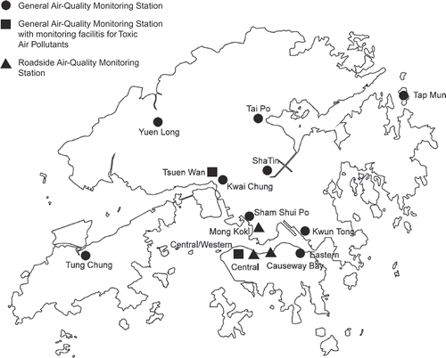
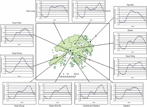
Hourly RSP data from 11 Environmental Protection Department (EPD) general observing stations for the period 2000–2008 taken by Hong Kong Environmental Protection Department (HKEPD) are used. The general stations include Yuen Long (YL), Tai Po (TP), Shatin (ST), Tap Mun (TM), Tsuen Wan (TW), Kwai Chung (KC), Central and Western District (CW), Sham Shui Po (SSP), Eastern District (ED), Tung Chung (TC), and Kwun Tong (KT) as shown in . Hourly data of the pollutants listed in tabulated form in Excel Spreadsheets can be easily downloaded from the HKEPD Website (Hong Kong Environmental Protection Department). Hourly meteorological data, including wind direction, are available from the HK Observatory Website (Hong Kong Observatory Citation2009). Statistics are compiled for winter (December of the previous year, January, February), spring (March, April, May), summer (June, July, August), and autumn (September, October, November) for seasonal studies.
Figure 1. Location of air-quality monitoring stations in Hong Kong (HKEPD, Citation2009).
3. Analysis and results
3.1. Annual mean and seasonal variations
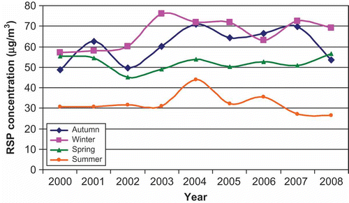
shows the annual and seasonal mean RSP for all stations in HK. The means are obtained by averaging all stations. The annual average (average of all four seasons) shows a maximum in 2004, with yearly maximum in all seasons except spring. Seasonal maximum concentrations were generally recorded in winter (except 2001 and 2006), followed by autumn (except 2000 and 2008). RSP concentration is lowest in summer in all years.
Figure 2. Interannual variation of seasonal RSP.
shows the annual average RSP concentration (center map) and their seasonal variations (inserts). The annual mean RSP concentration over the territory is fairly evenly distributed, with a range of 46–61 μg m−3. Stations with annual RSP concentration over 55 μg m−3 are found in the city and central, with lower concentration on the eastern (ST, TP, TM), southern (ED), and western (KC) sides. The highest concentration is found in YL in the north.
Figure 3. Spatial and seasonal variations of RSP in general monitoring stations in Hong Kong. The center map shows the annual mean distribution of RSP. The inserts show the seasonal variations for each general station (in μg m−3).
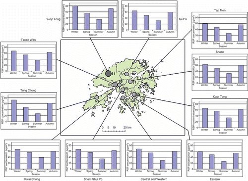
In terms of seasonal variation, winter maxima are observed in the range of 60–80 μg m−3, followed by fall and spring concentration, with minimum concentration in summer of <40 μg m−3. In spring, most stations show concentrations below 55 μg m−3 except YL, SSP, and KT (56 μg m−3). The RSP concentration in autumn rises to over 60 μg m−3 for most stations. Among them, the concentration of YL reached 71 μg m−3. In winter, over two-third of the stations recorded concentration of >65 μg m−3. The concentration in YL and TC approached annual peaks of 81 and 73 μg m−3, respectively.
3.2. Interannual variation of RSP distribution
shows the distribution of hourly RSP concentrations for 11 general monitoring stations. Quartiles for RSP concentration are computed. In addition, the 90 percentile is also included to show the extreme cases. The World Health Organization (WHO) hourly standard suggests annual averaged RSP concentration should not exceed 25 μg m−3. The WHO standard is deemed to be too restrictive to be applied for HK and the HKEPD uses 55 μg m−3 as a standard for compliance.
Figure 4. Quartiles and 90 percentile of RSP distribution of annual RSP concentration of 11 general air-quality monitoring stations: (a) Central and Western, (b) Eastern, (c) Kwai Chung, (d) Kwun Tong, (e) Sham Shui Po, (f) Shatin, (g) Tap Mun, (h) Tai Po, (i) Tsuen Wan, (j) Tung Chung, (k) Yuen Long. Straight lines show the 55 μg m−3 threshold. The horizontal and vertical axes show the year and RSP concentration in μg m−3, respectively.
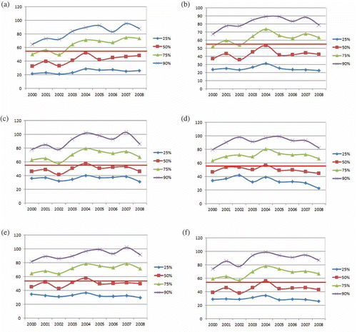
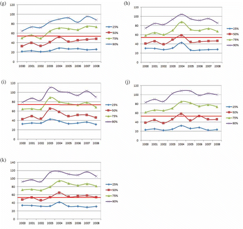
The RSP distributions show that the hourly data have a relatively large standard deviation. In most stations, their median is around the HKEPD standard, that is, these stations are compliant with the EPD standard 50% of the time. In YL, the median is higher than the EPD standard in most years whereas in stations like CD, ST, TP, and TM the median RSP concentrations are generally lower. The general trends of these percentiles are quite similar over the 9 years. Most stations showed peaks in 2004 and the minimum in either 2000 or 2002, consistent with our previous findings (Chiu and Lok Citation2008). However, TM recorded significant increasing trends for all percentiles, particularly in the high percentile cases.
3.3. Diurnal cycle
Hourly data for 9 years are first averaged to obtain climatological seasonal diurnal cycles. Two diurnal peaks are observed in most stations in winter while a single peak is often observed in summer. In spring and autumn, the situations are rather diffuse, with about half of the stations showing double peak and the other single or no significant peak at all. The hourly data are then standardized by subtracting the hourly data from its seasonal daily average value and dividing them by the daily standard deviations (of the hourly data) for each season. This procedure puts equal weights for each season and reduces the dominant effect of the winter season fluctuations. shows the annual diurnal cycles of RSP. An obvious diurnal cycle with bimodal patterns exists in most stations. Minimum concentration for RSP is recorded in the early morning at around 4–5 a.m. Their concentration started to increase sharply after 7 a.m. and reached the first peak at around 9–10 a.m. The concentration tapers after the first peak and then increases again to the secondary peak in evenings (around 7–9 p.m.). The concentration diminishes steadily after the second peak until the early morning next day. TM shows only a single diurnal peak suggesting that its influence by the territory daily traffic pattern is minimal.
Figure 5. Standardized diurnal cycle of RSP in Hong Kong.
3.4. Weekly cycle
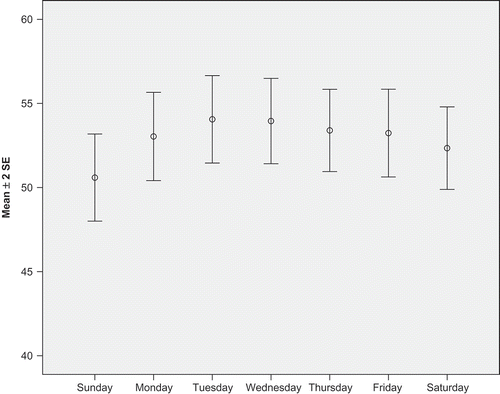
Daily data are also binned according to the days in a week, that is, Sunday to Saturday. shows the weekly climatology for RSP, with error bars showing 2 standard errors of estimation. Sunday shows the lowest RSP concentration while Tuesday shows the highest. Paired sample t-test showed significant difference (95%) between Sunday and the other weekdays except Friday, which is only significant at 90%.
Figure 6. Weekly cycle of RSP with error bars indicates 2 standard errors of estimation.
3.5. Wind effects
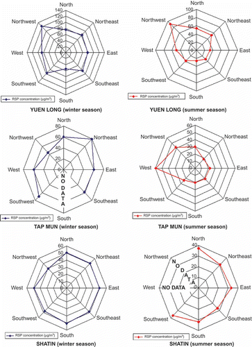
To examine the importance of cross-boundary transport of RSP, we compile daily RSP according to the prevailing wind directions. Only three districts, YL, ST, TM, with both daily wind and RSP data available via the Web, are analyzed. RSP concentrations are binned into eight wind categories, that is, north (± 22.5 degrees from north), northeast, east, southeast, south, southwest, west, and northwest. The data are further examined for winter and summer since the monsoon circulations in HK are very different during these periods. shows the RSP concentration as a function of wind direction for the year and shows that for winter and summer. All stations recorded minima for southerly winds. In ST, RSP shows a maximum with westerly and a minimum for northwesterly and northerly winds for the year; however, there are probably not enough samples for the year as there are very little data for these wind directions in winter and summer. There is no directional preference for both winter and summer RSP concentration. The RSP concentration in TP is low all year round except when northeasterly dominates in winter. RSP concentration is higher when the wind is from the mainland than that from the sea. The seasonal and cross-border influences are clearly seen in YL, where the RSP concentration reaches a maximum (120 μg m−3) for northwesterly, and a minimum (60 μg m−3) when the wind is southerly. In winter, the RSP concentration of YL is higher than the threshold of 55 μg m−3 for all wind directions, whereas in summer, the RSP concentration is less than the threshold, except for northwesterly.
Figure 7. Climatology of RSP concentration for different wind directions in Shatin, Tap Mun, and Yuen Long.
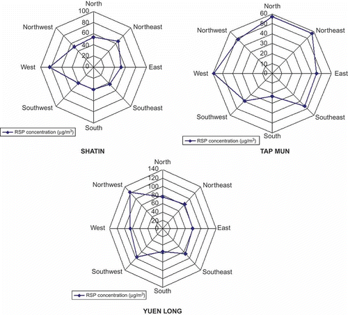
Figure 8. Climatology of RSP concentration with respect to different wind directions in summer and winter seasons in Yuen Long, Tap Mun, and Shatin.
We examined high RSP cases to quantify the cross-border effect. summarizes the yearly number of noncompliant cases (hourly concentration >55 μg m−3) for the stations. YL has the highest total daily noncompliance cases (1560 days) while TM has the lowest (1092 days). Out of these noncompliance cases, around 50% are associated with prevailing wind from mainland in ST, 40% in TM, and only 35% for YL. Overall, the noncompliance cases due to cross-boundary effect are 42.8%. Again, note the increasing trend in TM during the 9 years while the cross-boundary influence on ST and YL shows no obvious trend.
Table 1. Cases of daily RSP that exceed the HKEPD standard of 55 μg m−3 in Yuen Long, Shatin, and Tap Mun from 2000 to 2008
RSP concentrations are further grouped into two wind categories, that is, wind from mainland (west, northwest, north, and northeast) and wind from the sea (east, southeast, south, and southwest), representing cross-boundary transport and pristine air from the sea, respectively. All three stations show significant difference between the RSP concentration for winds from the land and from the sea. While the ratio of RSP concentrations between cross-border and pristine cases are about 1.44–1.47 for TM and ST, it is 1.75 for YL (see ).
Table 2. RSP concentration under different prevailing wind conditions
3.6. Nonseasonal variations
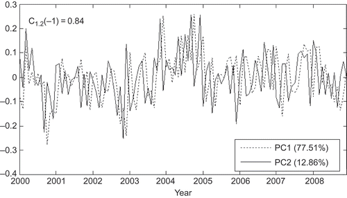
An empirical orthogonal function (EOF) analysis was performed on the monthly RSP data to delineate dominant modes of variations. Seasonal climatology was first removed to form nonseasonal variations. The first and second nonseasonal EOFs explain 71.5% and 12.9% of the variance, respectively, and are significant and distinct (North et al. Citation1982). shows the time series of the first and second EOF (PC1 and PC2). shows the spatial distribution of the EOF patterns. The size of the dots on the map represents the weights of the EOF pattern. The first EOF pattern is dominated by variations of the same sign in stations stretching in a SW–NE direction across the city, indicating the whole district varies in phase. The second EOF is characterized by variations in YL and TM. Correlation analyses show a significant lag correlation between the PC1 and PC2, with PC2 leading PC1 by 1 month (C– 1 = 0.84). This correlation and corresponding EOF patterns can be interpreted as the southward intrusion of the RSP across the northern border of the territory. Areas close to the mainland boundary are affected first, before the impacts are felt by the stations in the central part of HK.
Figure 10. Spatial pattern of (a) EOF 1 and (b) EOF 2 for nonseasonal RSP.
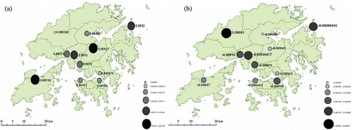
Figure 9. Time series of first and nonseasonal RSP concentrations of EOF for the period 2000–2008 (PC1 and PC2).
4. Discussions and conclusions
The RSP concentration in HK is due to vehicular emission, power plant generation, and cross-boundary transport. From an analysis of 9 years (2000–2008) of RSP data, it is shown that annual average RSP concentration is fairly evenly distributed, with the highest in YL, and lowest in Central district and TM. The high RSP concentration in YL may be due to (1) the local geography as YL is a plain which favors trapping of pollutants; (2) the power plant located in Tuen Mun, which transports additional RSP when wind is southwesterly, and (3) cross-boundary transport from the mainland. The significance of cross-border transport is clearly demonstrated by the analysis on wind effects.
RSP concentration is highest in winter, followed by autumn, and lowest in summer, consistent with early studies (Wang and Lu Citation2005, Chiu and Lok Citation2008). This large seasonal variation is largely related to cross-boundary transport by the seasonal monsoon system, with northerly in the winter and southerly in summer. The atmosphere tends to be more stable in winter, with shallower boundary layers, thus trapping pollutants and increasing the concentration at ground level. In summer, the winds are mostly from the sea. The heavy rainfall (over 70% of the yearly rainfall) brought by summer monsoon, as well as through systems, removes ground-level RSP by wet deposition. There is also strong summertime convection which maintains a higher boundary layer.
RSP also showed distinct diurnal cycles which are associated with local traffic conditions. Traffic flows are low from midnight to early morning (2–6 a.m.) resulting in minimum of RSP during these hours. The traffic flow increases as the morning begins, cumulating to an initial peak around noon hours. The ground-level RSP concentration is lowered by the increasing boundary layer as the day progresses. The evening peak (usually around 6–8 p.m.) coincides with the high traffic pattern associated with after work and evening activities. The lack of a double peak in TM can be interpreted by its distance from the main territory and hence the influence of vehicle emission. The delayed RSP daily peak in TM in late morning is suggested to be related to the cargo shipping associated with the Yan Tian International Container Terminal (YICT) in Shenzhen. The peak usage in the port is in late morning to afternoon, thus contributing to the late morning–mid-day peak of RSP in TM. Our analysis is consistent with the findings of Cheng et al. (Citation2006). Other than anthropogenic factors, the diurnal pattern can also be related to local meteorological factor. The local sea breeze is dominant (lower RSP concentration) in midnight to early morning while land breeze (higher RSP concentration) occurs in the rest of the time especially in late afternoon to early evening. Both meteorological and anthropogenic factors are affecting RSP diurnal cycle pattern (Zhang and Zhang Citation1997, Liu and Chan Citation2001, Lu et al. Citation2009).
We detect a significant weekly cycle, with weekday maximum and Sunday minimum, followed by Saturday, which is consistent with the weekly social activities (Blanceard and Tanenbaum Citation2003, Baumer et al. Citation2008, Murphy et al. 2008). This is related to the traffic amount; the majority of people normally do not work on Sundays, and only half day on Saturdays, thus reducing the demand of buses and private car use, as evident in a less frequent bus schedules on Sundays.
Cross-boundary transport of RSP is recognized through the analyses of relationship between RSP concentration and prevailing wind directions. Manufacturing industries in the PRD area produces aerosols including RSP and are transported downwind to several thousand kilometers from the source. The predominately winter north/northwesterly contributed significantly the higher RSP concentration in HK winters. During Summer monsoon seasons, HK is dominated by southerlies that bring pristine oceanic air and heavy rainfall, speeding up the removed by wet deposition and lowering the RSP concentration.
Lau et al. (Citation2007) estimated that cross-boundary transport accounted for around 132 days while local emission is responsible for 192 days of heavily polluted days in HK in 2007, or ∼41%, which is comparable to our estimate of 42% of noncompliant cases over the 9-year period. It is argued that this may be an upper limit since local emission can dominate while the influence of cross-boundary transport is minimal for these cases. Therefore, local generation of RSP cannot be neglected, as it contributes to >50% (58%) of noncompliant cases.
TM experiences significant increases in RSP concentration, which may be related to cargo shipping and its proximity to the YICT located to its northwest. YICT has emerged as a leading cargo terminal in China and the world (COSCO Pacific Citation2003). The cargo throughput of YICT increases steadily from around slightly over 2 million Twenty-foot Equivalent Units (TEU) in 2000 to over 9 million TEU in 2007, after which it tapers to slightly less than 10 million TEU for 2009 and 2010 (COSCO Pacific Citation2003, 2010, Lu et al. Citation2009). (A standard container cargo unit of 40' × 8' × 8' is equal to two TEU.) Cargo shipping constitutes about half of vehicular emission. A correlation of 0.78 is also found between the annual RSP concentration and yearly throughput of YICT for 2000–2008. Further monitoring and analysis of the pollutant concentrations in TM is needed to quantify its shipping impact.
An EOF analysis showed a relatively consistent change in pollutants throughout the district of HK. There is a high lag correlation (C– 1 = 0.84) between the time series associated with the first and second EOF patterns. Together with the spatial patterns, they can be interpreted as changes occurring first in YL and the northern areas, before the high RSP concentration spreads to the central part of HK. This phenomenon is related to cross-boundary transport. Our analysis indicates that YL has the highest RSP concentration when northwesterly prevails, which implies there is a substantial amount of RSP from the PRD industrial area. This could also give us a clue on why the pattern of RSP in YL changes first since it is the first place to receive the RSP from PRD industrial areafor HK.
This article presents an analysis on the RSP situation in HK. Application of the results includes constructing detailed models on estimation of district pollution level based on the importance of wind and local source, management of flexible working hours, traffic management planning, providing possible health guidelines for residents who have long-term health problems, including the best time to perform outdoor activities. As the HK government intends to review the EPD compliance benchmarks of pollutants (i.e., 55 μg m−3 for RSP), such as imposing standards closer to the WHO standard (i.e., 25 μg m−3 for RSP), policies such as the promotion of hybrid private cars/buses, encouragement of public transport use, and traffic management plans to reduce traffic road time should be considered, thus providing a healthier environment, more competitive business environment, and sustainable growth for our next generation.
Acknowledgments
We thank Prof. Hui Lin and Yuanzhi Zhang for their support and comments and Dr. R. Chokngamwong and Stephen P.W. Lau for discussion and programming assistance. The meteorological and air-quality data are provided by the HKO and HKEPD, respectively. The shape file of the base map of Hong Kong is provided by the CUHK Geography and Resources Management Department. This core of the analysis was performed while the authors were with CUHK/ISEIS and supported by ITF GHP/002/07 and CUHK DG 2020965.
Notes
Raymond Kwok-Cheung Lok is currently affiliated with the HK Transport Department.
References
- Baumer , D. , Rinke , R. and Vogel , B. 2008 . Weekly periodicities of aerosol optical thickness over Central Europe – Evidence of an anthropogenic direct aerosol effect . Atmospheric Chemistry and Physics , 8 : 83 – 90 .
- Bell , T.L. 2008 . Midweek increase in US summer rain and storm heights suggests air pollution invigorates rainstorms . Journal of Geophysics Research , 113 : D02209 doi: 10.1029/2007JD008623
- Blanceard , C.L. and Tanenbaum , S.J. 2003 . Differences between weekday and weekend air pollutant levels in Southern California . Journal of Air Waste Manage , 53 : 816 – 828 .
- Cheng , Y. 2006 . Seasonal and diurnal variations of PM1.0, PM2.5 and PM10 in the road side environment of Hong Kong . China Particuology , 4 ( 6 ) : 312 – 315 .
- Cheung , S. and Lam , K.-C. 1997 . An analysis of winds affecting air pollution concentration in Hong Kong . Atmospheric Environment , 32 ( 14/15 ) : 2559 – 2567 .
- Chiu , L.S. 2011 . “ Aerosol-climate interactions: examples from Hong Kong and the Pearl River Delta region ” . In New developments in environmental pollution and climate change , Edited by: El Nemr , A. New York: Research Signpost/Transworld Research Network . in press
- Chiu , L.S. and Lok , K.-C. 2008 . Variations of aerosol and wet deposition in Hong Kong: preliminary results . Geographic Information Science , 14 ( 2 ) : 92 – 98 .
- COSCO Pacific, 2003. COSCO Pacific annual report (2003), COSCO Pacific [online]. http://www.coscopac.com.hk/big5/ir/reports/03arbreakdown/containerterminal.pdf (http://www.coscopac.com.hk/big5/ir/reports/03arbreakdown/containerterminal.pdf) (Accessed: 14 April 2010 ).
- COSCO Pacific, 2010. Monthly throughput of main container ports, COSCO Pacific [online]. http://www.coscopac.com.hk/eng/media/operational_data.php (http://www.coscopac.com.hk/eng/media/operational_data.php) (Accessed: 14 April 2010 ).
- Harley , R.A. 2005 . Changes in motor vehicle emissions on diurnal to decadal time scales and effects on atmospheric composition . Environmental Science and Technology , 39 : 5356 – 5362 .
- Hong Kong Environmental Protection Department, (various years). Environmental Protection Department online website, Hong Kong SAR Government [online]. http://www.epd.gov.hk/epd/eindex.html (http://www.epd.gov.hk/epd/eindex.html) (Accessed: 10 October 2009 ).
- Hong Kong Observatory, 2009. Hong Kong Observatory online website, Hong Kong SAR Government [online]. http://www.hko.gov.hk/contente.htm (http://www.hko.gov.hk/contente.htm) (Accessed: 10 October 2009 ).
- Hopkinson , L. and Stern , R. 2002 . One country, two systems, one smog cross-boundary air pollution policy challenges for Hong Kong and Guangdong . China Environment Series , 6 : 19 – 36 .
- Lau, A.K.-W., et al., 2007. Relative significance of local vs. regional sources: Hong Kong's air pollution, Civic Exchange [online], pp. s36 http://www.civic-exchange.org [Accessed 14 April 2010] (http://www.civic-exchange.org [Accessed 14 April 2010])
- Lee , Y.C. and Savtchenko , A. 2006 . Relationship between air pollution in Hong Kong and in the Pearl River Delta Region of South China in 2003 and 2004: an analysis . Journal of Applied Meteorology and Climatology , 45 ( 2 ) : 269 – 282 .
- Liu , H. and Chan , J.C.L. 2001 . An investigation of air-pollutant patterns under sea-land breezes during a severe air pollution episode in Hong Kong . Atmospheric Environment , 36 : 591 – 601 .
- Louie , P.K.K. 2004 . Seasonal characteristics and regional transport of PM2.5 in Hong Kong . Atmospheric Environment , 39 : 1695 – 1710 .
- Lu , X. 2009 . Seasonal variation of the land-sea breeze circulation in the Pearl River Delta region . Journal of Geophysical Research , 114 : 1 – 14 . D17112,doi: 10.1029/2009JD011764:
- North , G.R. , Bell , T.L. and Cahalan , R.R. 1982 . Sampling errors in the estimation of empirical orthogonal functions . Monthly Weather Review , 110 : 699 – 706 .
- Qin , Y. , Chan , C.K. and Chan , L.Y. 1997 . Characteristics of chemical composition of atmospheric aerosols in Hong Kong: spatial and seasonal distributions . The Science of the Total Environment , 206 : 25 – 37 .
- School of Public Health, The University of Hong Kong, 2010. Hedley Environmental Index [online]. http://hedleyindex.sph.hku.hk/home.php#s (http://hedleyindex.sph.hku.hk/home.php#s) (Accessed: 14 April 2010 ).
- So , K.L. , Guo , H. and Li , Y.S. 2007 . Long term variation of PM2.5 levels and composition at rural, urban and roadside sites in Hong Kong: increasing impact of regional air pollution . Atmospheric Environment , 41 : 9427 – 9434 .
- Solomon , S. , eds. 2007 . The physical science basis. Contribution of Working Group I to the fourth assessment report of the Intergovernmental Panel on Climate Change , Cambridge/New York : Cambridge University Press .
- Wang , X.-K. and Lu , W.-Z. 2005 . Seasonal variation of air pollution index: Hong Kong case study . Chemosphere , 63 : 1261 – 1272 .
- Xiao , F. , Brajer , V. and Mead , R.W. 2005 . Blowing in the wind: the impact of China's Pearl River Delta on Hong Kong's air quality . The Science of the Total Environment , 367 : 96 – 111 .
- Zhang , L. and Zhang , M. 1997 . Study of the sea-land breeze system in Hong Kong . HKMetS Bulletin , 7 ( 1 ) : 22 – 43 .