Abstract
Applying remote sensing techniques to hard coral mapping in Hong Kong using SPOT satellite imagery is divided into two stages. At stage 1, any potential coral signals in the satellite imagery are detected by two methods. At stage 2, field spectral measurements are applied to the mapping, which will be conducted in the future work. Method 1 involves scanning the imagery and seeking the plant-like spectral signature that is associated with the symbiotic unicellular algae living inside the hard corals. Method 2 involves processing the imagery with per-pixel analysis using both supervised and unsupervised classifications. Without the field spectral measurements, the spectral signatures of the main habitats are derived from the imagery according to field map and informal field observation. They are first applied to supervised classification. Then, the unclassified class in the coastal submerged zone is analysed by unsupervised classification. The attempt to detect the potential coral distribution from the satellite imagery is not successful. It is found that the spectral resolution (both the band number and bandwidth) in the visible range determines the mapping success, in terms of the distinctiveness of the spectral signatures of the main habitats underwater and the effectiveness of water column correction, mainly depth.
Keywords:
1. Introduction
Hong Kong corals are mainly distributed in the northeastern part of its waters. Tung Ping Chau is the easternmost island in the territory that nurtures the diverse coral community, which attains high importance in the ecosystem (). It is designated the fourth marine park in Hong Kong, named Tung Ping Chau Marine Park in 2002. This project aims at mapping local corals using the remote sensing techniques on SPOT 5 satellite imagery. The feature of local corals is its existence in the form of community instead of reefs; hence, local corals have small geomorphologic scale. The target island, Tung Ping Chau, is situated at the eastern waters where the water quality is the best in the territory. However, it is still a challenge because the radiances of the bottom targets are much attenuated by the local water quality. To tackle the small scale of the local coral community, satellite imageries at high spatial resolution are used. At the first attempt, SPOT 5 satellite imagery is used, which is the best available resource in the present stage of research. SPOT 5 has spatial resolution of 10 m and 4 multispectral bands, including green (0.50–0.59 μm), red (0.61–0.68 μm), near infrared (NIR; 0.78–0.89 μm) and shortwave near infrared (SWIR; 1.58–1.75 μm). It is planned in the later stage to use other satellite imagery at higher spatial resolution, for example, IKONOS and WorldView, as well as at higher spectral resolution.
Figure 1. The field map of Tung Ping Chau Marine Park and a simple illustration of the horizontal profile of the coral area.
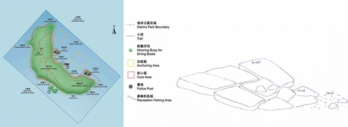
The reef area in Tung Ping Chau Marine Park is 0.032 km2 (Ang et al. Citation2005), compared to over 345,500 km2 in Great Barrier Reef Marine Park (Hutchings et al. Citation2009). Corals exist in colonies in Tung Ping Chau instead of extensive reefs. They attach to boulders and bedrock, and scatter along the coast. They form scattered fringing coral communities. Most of the hard corals along the island coast are found at about 1–3 m CD in depth, rarely more than 10 m CD (Lun Citation2001). They extend from the shore to sea in small range from a few metres to only tens of metres (Ang at el. Citation2005) ().
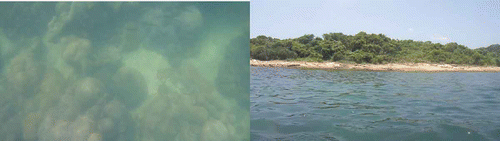
Figure 2. Corals in Tung Ping Chau. The far reach of the dense coral community from the shore (<10 m). Photos taken in July 2010.
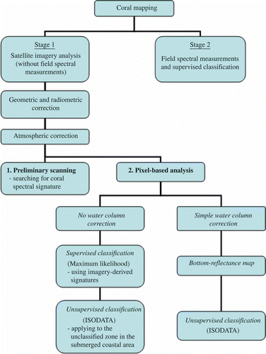
The basic concept of the research is to derive the spectral signature of corals from the SPOT imagery, which is then used to map corals along the coast of Tung Ping Chau by classification (). At stage 1 of the research, the imagery is processed and analysed on the Environment for Visualizing Images (ENVI) platform. At stage 2, the target spectral signatures will be collected in the field for imagery analysis in the future work.
Figure 3. Project strategy.
2. Methods and results
2.1. Geometric and radiometric correction
The Level 1A SPOT imagery acquired on 2 November 2003 is preprocessed both geometrically and radiometrically (Gao Citation2009). In methods 1 and 2, the digital number (DN) is converted to radiance and then reflectance for per-pixel analysis in ENVI. The geodetic datum is HK80 grid (Lands Department HKSAR).
DN is converted to radiance according to EquationEquation (1)1, which is retrieved from the technical document, SPOT Image Quality Performance (CNES Citation2009):
The radiance is converted to reflectance according to EquationEquation (2)2, which is retrieved from the Landsat 7 Science Data Users Handbook. The other required parameters of the satellite imagery are mean solar exoatmospheric irradiance, Julian day and zenith angle:
2.2. Atmospheric correction
Fast Line-of-sight Atmospheric Analysis of Spectral Hyper cubes (FLAASH) in ENVI is used in atmospheric correction of SPOT imagery. Tropical and urban atmospheric models are chosen for Hong Kong. The reflectance is set to the scale of 10,000.
2.3. Water column correction (water depth)
The target reflectance at sea bottom is subject to atmospheric, water column and water surface interferences before reaching the satellite sensors. Within the water column, the downwelling irradiance/upwelling radiance is attenuated by the increasing depth in exponential manner. They are further attenuated by the water substances, including the organic and inorganic components of the coloured dissolved materials and the suspended matter via scattering, reflection and absorption. In addition, the atmospheric column and the water surface also interfere with the radiation via its transmission in the medium and at the interface.
The depth effect is removed using the simple water correction techniques using the ratio of attenuation coefficients of two selected bands in the multispectral satellite data. It is then used to derive the depth-invariant index, a presentation of the bottom reflectance without field depth measurements (Lyzenga Citation1978, Citation1981).
The algorithm for the measured bottom reflectance is a function of depth:
The ratio of attenuation coefficients of two selected bands, ki/kj , is derived from the linearized relationships between depth and the natural logarithm of the measured bottom reflectance in bands i and j.
The transformed measured bottom radiance is given as follows:
The ratio of attenuation coefficients, ki /kj , is the linear slope of the two bands (i and j) in transformed radiance (reflectance), or it is derived from the least square of the perpendicular distance from the linear slope, involving the variances of bands i and j, σ ii and σ jj and their covariance, σ ij :
The end product (depth-invariant index between bands i and j) is the y-intercept of the linear slope of two bands in transformed radiance (reflectance), or it is derived from the following equation (Mumby and Edwards Citation2000):
The bottom-reflectance map is produced using the ratio of attenuation coefficients of green band and red band. With the addition of the ratio between green band and NIR band, the two-layered image is used for classification.
2.4. Detection of potential coral distribution
Two methods of imagery analysis are applied. In method 1, the imagery is processed with preliminary scanning. The entire coast of Tung Ping Chau, both vertically and horizontally, is scanned and checked for any plant-like spectral signatures. The presence of plant-like signatures may indicate the presence of corals, which have the symbiotic unicellular algae in their living tissues. However, the signal may also indeed indicate the presence of plant in the coastal waters.
In method 2, four main habitats are defined according to the prior information search, for example, field maps and the informal field observations. They are sea, exposed rock, exposed sand and land vegetation. Without field data collection, their spectral signatures are derived from the satellite imagery by carefully selecting the representative pixels. The spectral signatures are then applied to supervised classification, maximum likelihood at 95% probability threshold. By comparing to the NIR band, which indicates the shoreline based on the high absorption of NIR and hence much less reflectance, the unclassified class derived from supervised classification in the submerged zone along the coast is further processed with unsupervised classification, ISODATA. It aims at checking for any particular group of spectral signature that may indicate the presence of corals. The whole process involves per-pixel analysis.
3. Results and discussion
3.1. Preliminary scanning
According to the field map, the two core coral areas in the imagery satellite are scanned and checked for any plant-like spectral signature, which may indicate the symbiotic unicellular algae (zooxanthellae) living inside the hard coral.
For terrestrial healthy plant, the spectral signature has an obvious surge in NIR. A relatively small peak shows green band with troughs in blue and red bands. For the aquatic plant or organisms with plant component in water, the obvious surge in NIR is much reduced due to its high absorption in water. And the whole signal is weakened due to attenuation in water column. The spectral signature in deeper zone may also be transformed to other patterns which leads to misclassification (Mumby and Edwards Citation2000). SPOT imagery has no blue band but green, red, NIR and SWIR bands. Therefore, the expected plant-like spectral signature has a small peak in green and very low value in NIR. Upon scanning, it is found that no plant-like spectral signature is detected. Therefore, per-pixel analysis is carried out.
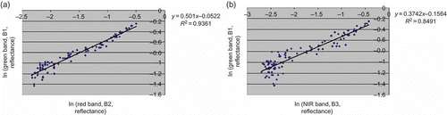
3.2. Water column correction
The ratios of attenuation coefficients of the two band pairs (k
1/k
2 for green/red band and k
1/k
3 for green/NIR band) are derived from two pools of submerged sand pixels. The ratios can be either retrieved from the graph slope or calculation (EquationEquations (4)4 and Equation(5)
5). In the submerged zone, which is defined by the dark/black pixels in NIR band, at the left tip of the island, the bottom-reflectance image (derived from k
1/k
2) and green band image show similar bottom structures (). They both also show similar bottom structures at the other part of the island. The band pair using green/NIR band produces ratio of attenuation coefficients at less desirable level at R
2 ∼0.78, compared with green/red at R
2 ∼0.92 (both R
2 are the means of two sand pixel pools). This is due to the stronger attenuation of NIR band since both ratios are derived from the same pool of sand pixels; hence, the variation of depth and water column are the same. It implies that on the contrary, the ratios, which are derived from bands at shorter wavelength in the visible range of electromagnetic radiation, are more correlated due to less attenuation. For k
1/k
2 and k
1/k
3 (), the depth decreases from the lower end of the regression line. It is found that the transformed data in both band pairs are less correlated at the deeper zones probably due to larger attenuation at such depth. And the de-correlation of transformed data at deeper zone is more prominent in green/NIR band than green/red band. It is probably caused by the larger attenuation in band of larger wavelength, NIR band, as induced above (since both ratios are derived from the same pool of sand pixels, the variation of depth and water column are the same) and shown in Pahlevan et al. (Citation2006) research. The ratios of two band pairs are produced for unsupervised classification in the submerged zone (Lyzenga Citation1981). No class representing corals is shown in the result of an unsupervised classification. It is found that the band combination is restricted by the three available bands. Strictly speaking, NIR is not desirable for deriving the ratio. Such attempts show that more band pairs and more visible bands are required.
Figure 4. Images in bottom reflectance with water column correction, green band and NIR band from left to right.
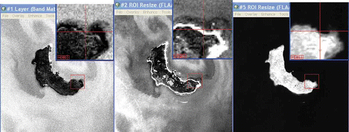
Figure 5. The ratios of attenuation coefficients, (a) green/red band and (b) green/NIR band from one of the two sand pixel pools (atmospheric corrected).
SPOT lacks blue band, and only two visible bands are available. It is predicted that the higher number of visible bands, particularly the inclusion of blue band as shown in SPOT analysis, allows more efficient water column correction and the subsequent classification due to the lower attenuation at shorter wavelength and the more band pairs. Satellite imagery at higher spectral resolution will be used in stage 2 of the research. The ratio processing (Lyzenga) method is assumed to apply in clear water. The water quality in Hong Kong is not clear, although the target island has the best quality in the territory. The suspended and coloured substances in water need to be removed in order to produce the bottom reflectance at higher accuracy.
3.3. Supervised classification
Two core coral areas are located at the east coast of Tung Ping Chau as shown in the field map. Four main habitat types, sea, exposed sand, exposed rock and land vegetation, are defined according to the field information and the informal field observation. The corresponding spectral signatures are produced by manually selecting pixels in the regions of interest with reference to the field map and photos. They are then applied to maximum likelihood at 0.95 probability threshold. By comparing with the shoreline shown in NIR band, the unclassified class along the coastline in the supervised classification is the main focus of the forthcoming unsupervised classification. Regarding the accuracy assessment, apparently there is no confusion between the four classes: exposed rock, exposed sand, sea and inland vegetation. The sandy beach outside the training sites of the exposed sand and the cliff outside the training sites of the exposed rock are classified correctly but not completely. Sea pixels and pixels of land vegetation are restricted to sea and land only. The coastline, which sits in the unclassified zone, is a combination of different habitats or it is the submerged zone.
3.4. Unsupervised classification
For the imagery without water column correction, the unclassified class generated in maximum likelihood at 95% threshold is then further analysed using ISODATA at a change threshold of 5%, and it is checked for any particular group of spectral signature that may indicate the presence of corals. Regarding the detection of coral signals, in upper core coral areas, the classes that sit in the submerged zones are the main focus, and they are verified with the book photos and the RGB false colour image. It is shown that the defined classes are submerged cliff, the possible algae on the ground near the submerged rock, the pier or the submerged rock/sandy bottom. As a whole, no coral signature is successfully detected in the submerged. The same method is also applied to the water-column-corrected image, and only one single class is defined. The classification thus failed.
3.5. Spectral resolution and spatial resolution
Both the absence of blue band and the broad bandwidth at 70–110 nm of SPOT 5 imagery cause the lower separability of target spectra. The spectral maxima and minima of coral and algal habitats may not be detected due to the absence of particular band and the diminishing power of water penetration at higher wavelength (Mumby et al. Citation1997). The separability of the target spectra as well as their spectra in deeper water can be raised by using satellite imagery from hyperspectral and narrow-band multispectral sensors (Kutser et al. Citation2002, Hochberg and Atkinson Citation2003). It is attempted to use satellite imagery at both higher spectral and spatial resolution. SPOT usage in coral mapping in Hong Kong is still under investigation since the water column correction also plays a key role. Without efficient water column correction, it is hard to say that SPOT is not applicable in Hong Kong, although it is highly likely to be the case.
To detect target in the satellite imagery, the spatial resolution is half of the target size. Thus, the small scale of the coral communities in Hong Kong requires satellite imagery at high spatial resolution. SPOT 5 may not suit the coral's small coverage (0.032 km2) and small dimensions, which extend a few metres to only tens of metres from the shore. At the present stage of coral mapping, we make use of the available resources at the highest spatial resolution, the SPOT 5 imagery. The success of coral mapping depends on different factors, such as the spatial and spectral resolution of the satellite imagery, the water column correction and the availability of field spectral measurements.
4. Conclusions
In the processing of satellite imagery, no plant-like signature is detected by imagery scanning and no potential coral signature is detected upon classification. The spectral resolution of SPOT 5 imagery, in terms of bandwidth and number of bands in the visible range, is found to be undesirable to map corals in Hong Kong. For water column correction, the ratios of attenuation coefficients are derived from visible bands (shorter wavelength), and the subsequent classification requires more than one band pair. SPOT lacks the blue band and only two visible bands are available. The hyperspectral or narrow-band multispectral imagery is more appropriate to distinguish water bottom features. The spatial resolution is another concern due to the small geomorphological scale and dimensions of coral communities in Hong Kong. This suggests that satellite imagery at higher spatial resolution and, particularly, higher spectral resolution is needed in the later stage of the research. The suspended and coloured materials in local waters are needed to be included in the water column correction due to the comparatively unclear water. The future work that involves the field spectral measurements is also crucial to the local coral mapping.
References
- Ang , P.O. 2005 . “ Japan Wildlife Research Center, Ministry of the Environment, Government of Japan ” . In Status of coral reefs of the East Asian Seas Region: 2004 , 121 – 152 . Hong Kong : Global Coral Reef Monitioring Network .
- CNES, 2009. SPOT image quality performance [online]. CNES. http://www.spotimage.com/web/en/555-spot-images.php (http://www.spotimage.com/web/en/555-spot-images.php) (Accessed: 15 July 2010 ).
- Gao , J. 2009 . Digital analysis of remotely sensed imagery , New York : McGraw Hill .
- Hochberg , E.J. and Atkinson , M.J. 2003 . Capabilities of remote sensors to classify coral, algae, and sand as pure and mixed spectra . Remote Sensing of Environment , 85 : 174 – 189 .
- Hutchings , P. , Kingsford , M. and Hoegh-Guldberg , O. 2009 . The Great Barrier Reef: biology, environment and management , Australia : CSIRO Publication .
- Kutser , T. , Dekker , A.G. and Skirving , W. 2002 . Detecting coral reef substrate types by airborne and spaceborne hyperspectral sensors . Proceedings of SPIE , 4544 : 93 doi:10.1117/12.452747
- Lands Department, HKSAR. Explanatory notes on geodetic datums in Hong Kong [online]. Lands Department, HKSAR. http://www.geodetic.gov.hk/smo/gsi/data/pdf/explanatorynotes.pdf (http://www.geodetic.gov.hk/smo/gsi/data/pdf/explanatorynotes.pdf) (Accessed: 1 September 2010 ).
- Lun , C. 2001 . Knowing corals , Hong Kong : Friends of the Country Parks .
- Lyzenga , D.R. 1978 . Passive remote sensing techniques for mapping water depth and bottom features . Applied Optics , 17 : 379 – 383 .
- Lyzenga , D.R. 1981 . Remote sensing of bottom reflectance and water attenuation parameters in shallow water using aircraft and Landsat data . International Journal of Remote Sensing , 2 : 71 – 82 .
- Mumby , P. and Edwards , A. 2000 . “ Water column correction techniques ” . In Remote sensing handbook for tropical coastal management , Edited by: Green , E.P. , Mumby , P.J. , Edwards , A.J. and Clark , C.D. 121 – 128 . Paris : UNESCO Publication .
- Mumby , P.J. 1997 . Coral reef habitat mapping: how much detail can remote sensing provide? . Marine Biology , 130 : 193 – 202 .
- Pahlevan , N. , Valadanzouj , M.J. and Alimohamadi , A. May 2006 . “ A quantitative comparison to water column correction techniques for benthic mapping using high spatial resolution data ” . In ISPRS Commission VII mid-term symposium “Remote Sensing: From Pixels to Processes” May , 8 – 11 . Enschede, , The Netherlands. Dubai: GIS Development 2006
- USGS. Landsat 7 Science Data Users Handbook [Online]. http://landsathandbook.gsfc.nasa.gov/program/ (http://landsathandbook.gsfc.nasa.gov/program/) (Accessed: 1 August 2010 ).