Abstract
In this article, we study the spatial knowledge issue of pedestrians while simulating their routing behaviors in agent-based simulation research. As the data collected from a field survey conducted in a real event case exposed, we proposed a personalized spatial cognitive road network (PSCRN) model, which assumes that different pedestrians hold different probabilities of recognizing a particular road for evacuation due to different spatial cognition under the incomplete spatial knowledge hypothesis. The multivariate binary logistic regression method was applied to identify the linkage between the predictors selected and the response probability variable quantitatively, and the Hosmer–Lemeshow statistic was used to test the regression model. Thus, in agent-based simulations for a given pedestrian, the PSCRN model could predict the recognized roads that the pedestrian was able to take for evacuation with respect to the diversity of spatial cognition lying in the public rather than every road as the complete spatial knowledge hypothesis assumes.
1. Introduction
1.1. Complete spatial knowledge assumption
To facilitate crowd evacuation management during potential emergencies, many efforts have been made to simulate pedestrian behavior by applying the agent-based modeling scheme, which seeks to present the behaviors of pedestrians in the evacuation at microscopic level (Feinberg and Johnson Citation1995, Pidd et al. Citation1996, Kerridge et al. Citation2001, Batty et al. Citation2003, Chen et al. Citation2006). These researches simulated pedestrian behaviors including leaving a building in a fire emergency, street movements and even urban hurricane evacuation and produced quite meaningful outputs including evacuation time estimation (Lo et al. Citation2001, Lindell and Prater Citation2007) and bottleneck analysis (Pan et al. Citation2007).
To abstract the kernel simulation process ignoring the spatial environments, pedestrians were represented as acting agents that moved toward their destinations within the action space. As stated by Lovas (Citation1998), the most complex issue during simulating the pedestrian walking process is the selection of routes. He summarized the main wayfinding strategies from the mathematical perspective including ‘always turn left,’ ‘random choice,’ ‘directional choice,’ and ‘shortest path.’ These strategies were suitable in different scenarios implemented in the current research. However, a prior assumption was set in these investigations, namely that each road or each cell in the simulated area was able to be taken into consideration by each pedestrian. Compared with the wayfinding decision structure identified by Passini (Citation1981) and Passini and Proulx (Citation1988), the current routing models covered the latter two phases of making the route plan and executing the plan, whereas the first phase of processing the spatial knowledge from individual experience was not well considered, which means the answer to the precondition question whether all roads in the area could be accessed by every pedestrian agent was assumed to be certain.
In the field of building fire evacuation, the assumption was acceptable because in such scenarios, the evacuees involved probably have full sight of the threatening room or are familiar with passages inside the building. In the context of evacuation at street or urban scale, it still appears rational to accept this assumption for the purpose of making optimized evacuation planning aimed at evacuating the involved crowds at maximum efficiency by making use of every possible road. However, for the purpose of simulating the pedestrian evacuation behavior without mandatory instructions from police officers, especially during tourism events such as the sample case addressed by this article, the assumption is not so reliable, and this kind of simulation is usually helpful for the police department to identify those roads that would be overcrowded with high risk when preparing for any possible emergency.
1.2. Incomplete spatial knowledge assumption
Contrary to the complete spatial knowledge assumption, some other simulations employ the incomplete spatial knowledge assumption, which assumes that only part of the entire road network could be recognized and accessed by the evacuating pedestrians. Two survey studies (Pailhous Citation1969, Chase Citation1982) on wayfinding behaviors of taxi drivers in Paris and Pittsburgh, respectively, indicated that even wayfinding experts like taxi drivers would stay on the network consisting of major arteries, which were called the skeleton network by Kuipers et al. (Citation2003), and experts knew more minor roads than novices. As Gwynne et al. (Citation1999) proposed to incorporate personal profiles of incomplete spatial knowledge of the area, it was expected to make more practical predictions of pedestrian behaviors in evacuation simulations.
Nevertheless, investigating the spatial configuration perceived by individual pedestrians that reflected the recognizable roads for routing was another perspective of individual spatial knowledge to be considered. As substantiated by Holding (Citation1994), humans organize spatial information hierarchically, which implies that different roads appear with different accessibility when finding a route. Johnson and Feinberg (Citation1997) also found that spatial configuration had significant impacts on surviving. Pires (Citation2005) proposed an effort to model and analyze this cognition effect from the perspective of reaction time to motion and explained the mechanics of crowding due to movement delay.
1.3. Personalized spatial cognition
With respect to the diversity of spatial knowledge among a large population in outdoor events, we further extended the incomplete spatial knowledge assumption in which it was assumed not only that individual pedestrians have incomplete spatial knowledge about the affected area but also that different pedestrians hold different spatial maps in their minds as they derived individual road subnetworks, which may differ from person to person. By taking this extended incomplete spatial knowledge assumption, it could be inferred that one particular pedestrian has different probabilities of taking different roads for evacuation, and at the same time, one particular road would appear to have different probabilities of being taken by different pedestrians. Moreover, given a particular pedestrian, their individual road network, which is derived from the complete road network, is assumed to be related to the factors of the individual pedestrian. On the basis of the assumption and inference, we proposed the personalized spatial cognitive road network (PSCRN) model to deal with the relation between potential personal factors, which represent spatial cognitions of the pedestrian, and the roads that could be recognized by the pedestrian for making an evacuation route. For this purpose, this article is organized as follows. Section 2 presents the method of building the PSCRN model. Section 3 describes the field survey conducted in a real event, which was used as the sample case. Section 4 demonstrates the process of implementation of the model using the collected data. Section 5 discusses the application of the model, and the last section contains the conclusions.
2. PSCRN model
2.1. Definition
We define the PSCRN model as a personal road network incorporating the effects of individual spatial cognition for agent-based simulation. Each pedestrian agent involved in a simulation derives their own PSCRN comprising recognizable roads from the complete road set according to their spatial knowledge, and their spatial knowledge is affected by their personal factors.
For any one road in the complete set, let a two-value state variable, positive or negative, denote whether the road is recognized by an individual pedestrian. In addition, there is a hidden probability for the state being positive. Different pedestrians have different spatial knowledge perceiving the simulated district due to different individual factors; thus, the probability of the roads appearing in their PSCRN varies with the factors. Therefore, the process of building the PSCRN could be divided into two stages: first identifying related factors from candidates and second establishing the association between the probabilities of each road and these related factors.
2.2. Dependent and independent variables
According to the definition of PSCRN, which aims to expose the quantitative relation between individual spatial knowledge and personal factors, the dependent variable is required to represent the individual road network configuration in the pedestrian's mind. Here, the indicator of whether one particular road is selected by a given pedestrian into their road network was used as the dependent variable. This indicator, denoted by y, was a dichotomous variable with two possible outcomes representing the success or failure of a trial shown in EquationEquation (1)(1):
The independent variables were factors for an individual pedestrian, which could have impacts on the spatial knowledge of the pedestrian. It should be noted that different roads probably were affected by different pedestrian factors due to different spatial structures and social utilities. Suppose a road was affected by r factors of pedestrian individuals, then the independent variables could be denoted by .
For a given road R, the conditional probability of R being recognized by a certain pedestrian P was denoted as as EquationEquation (2)
(2) expresses:
where X P is the vector of related factors of P.
2.3. Identifying related factors
As different roads could be affected by different pedestrian factors for constituting PSCRNs, the first step is to eliminate unrelated factors from the initial predictors. In this step, multiple contingency tables are constructed to test the relation between the inspected roads and possible predictors. For a categorical response and predictor in this kind of behavior studies, Pearson's χ2 test is applied for examining the association between the response and the predictor.
We have shown above that response y could take one of two outcomes; now suppose the testing predictor x has m levels, then a contingency table could be derived. Let Yij
denote the observed frequency of the cell taking ith level of y and jth level of x, Ri
denote the marginal total of the ith row, and Cj
denote the marginal total of the jth column. In order to test the association of the response and the predictor, the null hypothesis that assumes the response and the predictor are independent is in the form of
, where pij
denotes the probability of the presence of cell ij and pi
+ is the marginal probability of the ith row and pj
+ the jth column. Then the expected frequency for Yij
is given by EquationEquation (3)
(3):
where N is the total number of survey forms. Therefore, Pearson's χ2 could be calculated (Howell Citation2002) from EquationEquation (4)(4):
with the degree of freedom . If
exceeds the corresponding critical value at significance level of 5%, the H
0 will be rejected, which means the testing predictor cannot be considered to be independent to the response; thus, the predictor will be included in the predicting model.
2.4. Regression model
For a typical dichotomous dependent variable regression model with a set of n continuous independent variables addressed by Cox (Citation1970), EquationEquation (5)(5) expresses the multivariate logistic regression model that fitted the situation:
where is the logit odds of the original conditional probability
as shown in EquationEquation (6)
(6):
For the situation in which categorical independent variables are involved, such as the nominal scale predictors in this kind of behavior study, dummy independent variables are constructed to represent the available states of the original nominal variables. For a nominal variable x with n states, n – 1 dummy variables could be constructed. As addressed by Hosmer and Lemeshow (Citation1989), suppose an independent variable xi
has ki
states, then the dummy variable series could be represented by , where
. illustrated the dummy variables constructed for the age group factor as an example. For reasons of convenience, the dummy variables were annotated with prefixes D in this article, so DA1 stood for the first dummy variable of the age group factor. Then EquationEquation (5)
(5) could be extended to the form of EquationEquation (7)
(7) for fitting the data with the multivariate logistic regression model for categorical independent variables:
Table 1. Dummy variables for factor age group
As the first step, the predictors were tested as to whether they had relations with the response variable individually; however, it was not clear whether one of the related predictors contributed as much as others. Therefore, in this step, the predictors were selected step by step based on the likelihood ratio. If adding one predictor significantly reduces compared with the null model, the predictor will be selected in the final model. Once the coefficients for all significant predictors are obtained using maximum log likelihood estimation as in EquationEquation (8)
(8) (Hosmer and Lemeshow Citation1989), the predicting model of the probability of the inspecting road could be calculated from EquationEquation (9)
(9):
Repeating this process for each involved road in the study area, the complete PSCRN model, which predicts probabilities of each road being selected by particular kinds of pedestrians with given attributes, could be derived in an agent-based simulation where each individual pedestrian is treated.
3. Case event and survey review
In this section, we review the field survey conducted in a real case event. The case event is briefly introduced first. The survey form is then described, and the collected data are summarized and cataloged, with the individual graded road map being given in the end.
3.1. The case event
The sample case studied in this article is the National Day Fireworks Display, one of the three annual display events taking place since the 1990s at Victoria Harbour of Hong Kong on 1 July (the Foundation Day of Hong Kong S.A.R.), 1 October (the National Day), and Chinese Lunar New Year, respectively, as celebration events. About 300,000 participants were involved in each event (HKPF Citation2008). At the time we investigated, the police department arranged the operation of evacuation plans based on sand-box games and paper maps in the current practice of emergency management, and they are expecting dynamic simulations for promoting the management. The main reason of choosing this kind of event is due to the large number of participants, coming from multiple sources including many foreign visitors, because of which the complete spatial knowledge assumption may be incompatible except for the local residents.
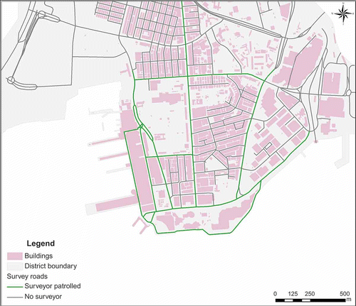
With authorization from the police department, the display event that took place at 9:00 pm on 1 October 2008 was selected as the sample case for this article. Because of the crowd management policy operated by the police department, the area was closed at 7:00 pm; the survey forms were distributed to the participants randomly along the streets in the study area from 3:00 pm to 6:00 pm. The survey was in the form of a two-page questionnaire. We had 38 student helpers employed to help distribute the survey forms. illustrates the roads where the student helpers distributed the survey forms. In total, we received 680 valid feedbacks and 1485 participants, ∼0.5% of the population involved in the survey because some of the pedestrians were in groups. Those pedestrians who were in groups were asked to select a representative to make decisions for the questionnaire.
Figure 1. Spatial distribution map of survey forms.
3.2. Selected indicators
As we had defined PSCRN as a subset cropped from the complete set of roads in the area, the survey was designed to investigate three questions including which roads could be recognized at what probabilistic level and which potential factors could be employed for explaining it. Previous research had investigated several social–economic factors. By conducting a series of psychometric and geographic tests for examining spatial abilities, Montello et al. (Citation1999) obtained evidence suggesting that males and females differ in spatial abilities and behavior styles, and especially more clearly when dealing with newly acquired spatial knowledge. In addition to gender, Aurbrey and Dobbs (Citation1990) had indicated that age also affected the pedestrian perception of routes through an experiment comparison study between young and elderly people. As a consequence, basic personal factors including gender, age group, and education level were placed in the first part of the survey representing social–economic terms.
Regarding participatory action research of the evacuation from the World Trade Center on 11 September 2001 (Gershon et al. Citation2008), the risk factors concerning spatial knowledge and more specifically the evacuation route had impacts on individual behaviors in the context of a high-rise building; the second set of factors related to spatial knowledge were also designed for investigation. As Golledge (Citation1992) addressed, spatial familiarity plays an important role in the representation of human spatial knowledge accurately; two indicators, place of residence and visiting frequency to this district, were designed to represent the familiarity with the study area. The pedestrians who are in the same category of living place and pay similarly frequent visits to this district are considered to have a similar pattern of space utilization and therefore tend to have a similar cognitive map in their minds. The respondents were asked to select the item that most closely described their characteristics from the available items.
In order to represent the personal cognitive road networks in respondents' minds, it is essential to identify which roads could be recognized by a particular respondent for evacuation with certain factors. Spiers and Maguire (Citation2008) found that road name was used by respondents for distinguishing a particular road from a road network; thus, we placed an open question asking the respondents to write down the names of the roads that they could make use of for emergency evacuation on the paper according to their own knowledge without any prompting (in the forms of maps or instructions). Since Kang et al. (Citation2007) had confirmed the consistency between respondents expected and actual behaviors in an evacuation, the propensities of the roads being selected by the respondents in this survey were used as the samples of the response variable in the proposed PSCRN model. In addition, when one road was mentioned by any respondent, the frequency of the road usage increased by one unit. Thus, we could obtain a large data sheet indicating how many times each road was mentioned by all respondents.
3.3. Survey data summary
In this section, the data are simply summarized through Tables . Looking into the data tables, several interesting findings were discovered. and present the fact that among the population of pedestrians participating in the display event, only a small part – more or less 15% – could be assumed to have complete spatial knowledge so that they could take each road into consideration when searching routes for evacuation. A major proportion of the
Table 2. Gender
Table 3. Age group
Table 4. Education level
Table 5. Residence zone
Table 6. Visiting frequency per month
Table 7. Road choice inclination
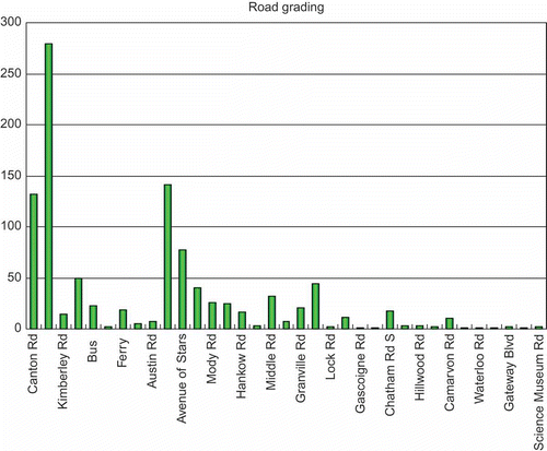
respondents at the display event (85%) lived outside the affected district or were even foreign tourists. On the other hand, over 60% of participants seldom visited this district. About one quarter came to this area weekly, maybe for shopping or other occasional reason. Only 13% had their lives spatially connected to this area because they frequently visited this area. Another interesting finding was that in indicating the road picking inclination, only one-fifth of pedestrians appeared to have the wish to find the shortest route to take while facing an emergency; however, nearly one half preferred the most familiar roads for their evacuation routes by contrast. Although the two principles, shortest route and most familiar roads, were sometimes not very conflicting if the shortest route was found from the most familiar roads, they provided support that it was more practical to conduct pedestrian evacuation simulation under the incomplete spatial knowledge assumption that the pedestrians were more likely to take the route made up by the roads they were familiar with rather than the theoretical shortest calculated with respect to every road in the district. presents the frequency distribution of the road usage. In this histogram, we found that there was a large variance among the frequencies of the roads. This variance implied a double-sided effect, which meant different roads held different chances of being selected by pedestrians from the road perspective and different pedestrians recognized different available roads from the pedestrian perspective.
Figure 2. Road grading chart.
On the basis of the percentages and the frequency distribution, we were encouraged to build PSCRN to reflect the impacts of cognitive factors as we assumed. In the following sections, we made an effort to expose the linkage quantitatively through the survey data.
4. Model implementation
In this article, the independent variables were connected to the investigating individual factors as we were interested in identifying their impacts on the behavior of spatial cognition of the pedestrians. Relevant variables from the data sheet covered two categories including basic personal backgrounds and spatial knowledge listed as follows with their coding values.
| • | Gender (G): 1:=male, 2:=female | ||||
| • | Age group (A): 1:=< 18, 2:=18–30, 3:=30–60, 4:=>60 | ||||
| • | Education level (E): 1:=secondary school and below, 2:=bachelor, 3:=master and above | ||||
| • | Residence zone (R): 1:=within the district, 2:=outside the district but in Hong Kong, 3:=outside Hong Kong | ||||
| • | Number of visits per month (V): 1:=never, 2:=1–4, 3:=4–10, 4:=>10 | ||||
Here, it was notable that all these variables were of nominal scale and took one of the available states as their current status. The values of the independent variables were only labels that suggest nothing numerically but only discreet categories.
By substituting all the dummy variables listed in into EquationEquation (7)(7), the complete predicting model of the probabilities of a certain road being selected to the PSCRN of a given pedestrian by their factors is presented in EquationEquation (10)
(10):
Table 8. Dummy variables for independent predictors
With the regression model built, we proposed two stages to build up the PSCRN model involving roads the interviewees mentioned in the survey based on the data collected. In the first stage, which aimed to determine which predictors were to be included in the regression model, all the five preliminary selected factors were examined individually in the χ2 independence hypothesis test against the investigated road. If the testing factor passed the test, which meant the factor was significant enough to explain the variance of the probability of successful trials, it was to be included in the model. After the relevant factors were determined individually through the univariate test, the second stage, which aimed to build the probability distribution prediction model of the investigated road being selected by a certain kind of pedestrians upon the recognized factors, was implemented through the multivariate binary logistic regression. During the regression, the factors that appeared somewhat related to the probability as they passed the χ2 test individually were optimized again from the joint perspective that only those statistically significant factors remained when checked simultaneously.
To demonstrate the building process of PSCRN, Canton Road was taken as an example. The probability that Canton Road was recognized and selected into the PSCRN of an agent was denoted by πCanton, and the initial predictors were gender, age group, education level, residence zone, and visiting frequency. In this article, we used SPSS (version 17.0 released by SPSS Statistics Inc.) to carry out statistical operations. For the first stage determining the related factors in selecting Canton Road through χ2 test, multiple two-way tables were constructed for testing correlations. and show the process for determining the factor gender.
Table 9. Cross tabulation for factor gender of Canton Road
Table 10. Chi-square test for factor gender of Canton Road
From , it can be found that the two-sided asymptotic significance value is greater than 0.1, which meant the factor gender was not significant for explaining the variance of the response variable πCanton at 95% confidence level (SPSS Citation2008). Therefore, the factor gender was eliminated in the prediction model. reported the χ2 test of the other four factors. According to the criterion addressed above, the factor residence zone was considered to be irrelevant to the variance of πCanton and was excluded from the model. Therefore, for Canton Road, the probability of it being selected to agent's PSCRN was a function of three factors, namely age group, education level, and visiting frequency. The model expression with dummy variables substituted is exhibited in EquationEquation (11)(11):
Table 11. Chi-square test for other factors of Canton Road
After the regression model expression was determined, the second stage was to calculate the coefficients through multivariate binary logistic regression in SPSS. The method of independent variables entering the regression model was ‘Forward Selection (Likelihood Ratio)’ in which only the significant variables would be selected step by step. lists the variables entered in the model and the coefficients (in column β) with their significance and indicates that the factor age group was not qualified to enter the model during the second stage, and then by substituting the coefficients into the regression expression of EquationEquation (11)(11), the completed model is given in EquationEquation (12)
(12):
Table 12. Logistic regression result
In order to evaluate how well the regression model fitted the data, the Hosmer–Lemeshow statistic (Hosmer and Lemeshow Citation1980) was tested like the usual categorical data analysis studies (Sze and Wong Citation2007). summarizes the test result. As the significance value of the test is 0.985, the predicting model could be considered as fitting the data quite well (SPSS Citation2008). Thus, it was indicated that the probability of Canton Road being recognized by a pedestrian to his PSCRN could be estimated through substituting his education level and visiting frequency (coded values) into EquationEquation (12)(12).
Table 13. Hosmer–Lemeshow statistic test
By repeating the above procedures throughout the other roads involved in the survey, coefficients of the regression model for each road were obtained and listed in with their goodness-of-fit test in Thus, the complete model of PSCRNs, which addressed the regression associations between the probabilities of each involved roads being selected and the relevant factors, was built.
Table 14. Regression coefficients for all roads
Table 15. Hosmer–Lemeshow test for all roads
5. Application and discussion
After implementing the PSCRN model based on the collected sample data, we designed the framework of applying this model into an agent-based simulation of pedestrian evacuation behaviors. In this application framework, when a pedestrian agent is produced into the simulation, their personal features will be decided randomly while following the distribution of such features as discovered in the survey. Then a loop for each road in the simulating area will be performed. At each step of the loop, one road will be investigated for calculating the probability that this road is included in the agent's PSCRN. By looking up for the coefficients, the regression function could be obtained and the probability could be derived by substituting the agent's features in the regression function of the road. According to this probability, a dice roll trial is performed in the simulation to finalize whether this road is recognizable for making an evacuation route.
One interesting issue was found in , namely that some of the roads were not related to any of the potential factors, which meant the probabilities of the roads being recognized by different kinds of people were constant. This was due to three possible causes. The first relates to the sample size since there were not enough people mentioning the roads in the survey so that the number of positive trials was not sufficient for the regression; the second concerned the independent factors, which were not significant enough to explain the variance of positive trials; and the last cause was that the roads were either mostly major or mostly minor roads, so the probabilities of these roads being recognized were fixed. Therefore in future studies, we propose an attempt be made to take more survey samples, up to 5% of the population, and to explore more potential factors related to spatial cognition.
By applying the PSCRN model, the pedestrian agents in the simulation were more realistic by using the incomplete spatial knowledge assumption compared with the complete assumption as the survey indicated. With this model, two spatially adjacent pedestrians could probably have different solutions of their preferred route to the same destination due to different configurations of PSCRN resulting from different personal features, which would be closer to the diversity of pedestrian spatial cognition present in a large population in real-world events.
6. Conclusions
As addressed in previous sections, we extended the incomplete spatial knowledge assumption employed in this article so that each road held a unique probability of being recognized by a particular kind of pedestrian. The probability has been revealed to be associated with the factors of the pedestrian, and a regression model has been established. Therefore, once given a pedestrian with their relevant factors determined, the established PSCRN model is able to construct a unique road network of the pedestrian representing their personal spatial cognition that only the roads in this individual's network were recognizable according to their spatial knowledge.
By conducting a field survey in a real event, sample behavioral data were collected. Survey questions covering basic features and spatial cognition terms that were assumed to have impacts on road recognition behaviors were investigated as initial factors. In order to identify the quantitative relationship between the selection probability and explanatory predictors, two stages were performed: identifying related factors and multivariate binary logistic regression, because the involved variables were of nominal scale, and the goodness-of-fit test was conducted as well to provide confidence from the statistical perspective. The complete PSCRN model has been established for the study case, which could be used for further agent-based simulation as the spatial cognitive routing space.
However, the evaluation issue was not well settled due to the lack of practical behavioral data of pedestrians in a real emergency. Although the pedestrians were asked to name the roads they could take for evacuation when by themselves, we are not sure whether they could recall these roads in a panicking crowd. Therefore, a gap between the prediction model relating to the spatial cognition and the real minds of pedestrians requires additional field emergency data of evaluation dynamics if permitted. Moreover, it was noted that as a case study this article proposed the PSCRN model and illustrated the building process. When applying this model in other outdoor events, a similar field survey would be needed to identify the spatial cognitive factors representing the incomplete spatial knowledge of the study area.
Acknowledgements
This article was prepared under the Competitive Earmarked Research Grant project titled ‘Modeling Pedestrian Evacuation Using a Geo-referenced Multi-agent Approach: Taking Hong Kong's Fireworks Show as a Sample Case’ funded since August 2008 by the Research Grants Council (RGC) Hong Kong (Reference No. CUHK 405608). The project is also partially supported by ‘The open research fund of State Key Laboratory of Resource and Environment Information System, Chinese Academy of Sciences.’ We greatly appreciate their support. And we express special thanks to the Hong Kong Police Force for permitting the conduction of survey in the field, especially Mr. Andy Naylor and Ms. Amy Cheng of Tsim Sha Tsui Police Station of Hong Kong who offered much assistance in organizing and distributing the survey forms. Finally, we are very grateful to the student helpers from The Chinese University of Hong Kong for their assistance in conducting the survey.
Related Research Data
References
- Aubrey , J.B. and Dobbs , A.R. 1990 . Age and sex-differences in the mental realignment of maps . Experimental Aging Research , 16 ( 3 ) : 133 – 139 .
- Batty , M. , Desyllas , J. and Duxbury , E. 2003 . The discrete dynamics of small-scale spatial events: agent-based models of mobility in carnivals and street parades . International Journal of Geographical Information Science , 17 ( 7 ) : 673 – 697 .
- Chase , W.G. 1982 . “ Spatial representations of taxi drivers ” . In The acquisition of symbolic skills , Edited by: Rogers , D. and Sloboda , J.A . 391 – 405 . New York : Plenum .
- Chen , X.W. , Meaker , J.W. and Zhan , F.B. 2006 . Agent-based modeling and analysis of hurricane evacuation procedures for the Florida keys . Natural Hazards , 38 ( 3 ) : 321 – 338 .
- Cox , D.R. 1970 . The analysis of binary data , London : Methuen .
- Feinberg , W.E. and Johnson , N.R. 1995 . Firescap: a computer simulation model of reaction to a fire alarm . Journal of Mathematical Sociology , 20 ( 2–3 ) : 247 – 269 .
- Gershon , R.R.M. 2008 . Participatory action research methodology in disaster research: results from the World Trade Center evacuation study . Disaster Medicine and Public Health Preparedness , 2 ( 3 ) : 142 – 149 .
- Golledge , R.G. 1992 . Place recognition and wayfinding – making sense of space . Geoforum , 23 ( 2 ) : 199 – 214 .
- Gwynne , S. 1999 . A review of the methodologies used in the computer simulation of evacuation from the built environment . Building and Environment , 34 ( 6 ) : 741 – 749 .
- HKPF, 2008. A busy day for frontline officers [online]. Hong Kong Police Force. http://www.police.gov.hk/offbeat/881/eng/n01.htm (http://www.police.gov.hk/offbeat/881/eng/n01.htm) (Accessed: 2 January 2010 ).
- Holding , C.S. 1994 . Further evidence for the hierarchical representation of spatial information . Journal of Environmental Psychology , 14 ( 2 ) : 137 – 147 .
- Hosmer , D.W. and Lemeshow , S. 1980 . Goodness of fit tests for the multiple logistic regression-model . Communications in Statistics Part A-Theory and Methods , 9 ( 10 ) : 1043 – 1069 .
- Hosmer , D.W. and Lemeshow , S. 1989 . Applied logistic regression , New York : Wiley .
- Howell , D.C. 2002 . Statistical methods for psychology , 5th , Pacific Grove , CA : Duxbury/Thomson Learning .
- Johnson , N.R. and Feinberg , W.E. 1997 . The impact of exit instructions and number of exits in fire emergencies: a computer simulation investigation . Journal of Environmental Psychology , 17 ( 2 ) : 123 – 133 .
- Kang , J.E. , Lindell , M.K. and Prater , C.S. 2007 . Hurricane evacuation expectations and actual behavior in hurricane Lili . Journal of Applied Social Psychology , 37 ( 4 ) : 887 – 903 .
- Kerridge , J. , Hine , J. and Wigan , M. 2001 . Agent-based modelling of pedestrian movements: the questions that need to be asked and answered . Environment and Planning B-Planning and Design , 28 ( 3 ) : 327 – 341 .
- Kuipers , B. , Tecuci , D.G. and Stankiewicz , B.J. 2003 . The skeleton in the cognitive map – a computational and empirical exploration . Environment and Behavior , 35 ( 1 ) : 81 – 106 .
- Lindell , M.K. and Prater , C.S. 2007 . Critical behavioral assumptions in evacuation time estimate analysis for private vehicles: examples from hurricane research and planning . Journal of Urban Planning and Development-ASCE , 133 ( 1 ) : 18 – 29 .
- Lo , S.M. , Fang , Z. and Chen , D. 2001 . Use of a modified network model for analyzing evacuation patterns in high-rise buildings . Journal of Architectural Engineering , 7 ( 2 ) : 21
- Lovas , G.G. 1998 . Models of wayfinding in emergency evacuations . European Journal of Operational Research , 105 ( 3 ) : 371 – 389 .
- Montello , D.R. 1999 . Sex-related differences and similarities in geographic and environmental spatial abilities . Annals of the Association of American Geographers , 89 ( 3 ) : 515 – 534 .
- Pailhous , J. 1969 . Representation of urban space and pathways . Travail Humain , 32 ( 3–4 ) : 239
- Pan , X. 2007 . A multi-agent based framework for the simulation of human and social behaviors during emergency evacuations . AI and Society , 22 ( 2 ) : 113 – 132 .
- Passini , R. 1981 . Wayfinding: a conceptual framework . Urban Ecology , 5 ( 1 ) : 17 – 31 .
- Passini , R. and Proulx , G. 1988 . Wayfinding without vision – an experiment with congenitally totally blind people . Environment and Behavior , 20 ( 2 ) : 227 – 252 .
- Pidd , M. , Desilva , F.N. and Eglese , R.W. 1996 . A simulation model for emergency evacuation . European Journal of Operational Research , 90 ( 3 ) : 413 – 419 .
- Pires , T.T. 2005 . An approach for modeling human cognitive behavior in evacuation models . Fire Safety Journal , 40 ( 2 ) : 177 – 189 .
- Spiers , H.J. and Maguire , E.A. 2008 . The dynamic nature of cognition during wayfinding . Journal of Environmental Psychology , 28 ( 3 ) : 232 – 249 .
- SPSS . 2008 . Helping document , Chicago , , IL : SPSS . 17.0 ed.
- Sze , N.N. and Wong , S.C. 2007 . Diagnostic analysis of the logistic model for pedestrian injury severity in traffic crashes . Accident Analysis and Prevention , 39 ( 6 ) : 1267 – 1278 .