Abstract
This study aimed at estimating herbage mass functional relationship with rainfall and selected soil morphological properties using Geographic Information Systems (GIS). Herbage mass as dry matter (DM) measurements from quadrat harvesting method and estimations based on grass cover were done. Herbage on 1 × 1 m quadrats was harvested and oven dried at 60°C until constant weight. Grass cover data collection was based on spectral strata of vegetation cover types obtained from Landsat image. Rainfall data were collected from 14 rain gauge stations. Soil profiles were described and their drainage was determined. A multi-linear regression analysis was performed to determine the relationship among DM, grass cover, rainfall effectiveness and soil drainage. The relationships among the variables were integrated using ModelBuilder in ArcGIS 9.3 to come up with spatial and seasonal herbage distribution. Results showed a strong relationship among the above variables and DM (R 2 = 0.76; p < 0.001). Grass cover was found to be the important variable for herbage DM determination (R 2 = 0.73; p < 0.001). A correlation analysis of estimated and harvested DM resulted in a positive relationship (R 2 = 0.85). Estimated DM ranged between 895 and 1923 kg/ha with the highest DM during March–May and the lowest during September–November. This study demonstrated that grass is an important proxy measure of spatial and seasonal patterns of rangeland herbage mass. Therefore, rangeland herbage can in reality be monitored based on grass cover measurements to avoid or at least minimize the cost, destruction and information timeliness implications that are known to be associated with harvesting methods.
1. Introduction
Herbage production in rain-fed rangelands is characterized by seasonal and annual disparities which are generally attributed to the erratic nature of rainfall (Tueller Citation1993; Fujita et al. Citation2009). Such changeability calls for continuous quantification and monitoring of herbage availability so as to provide reliable information for livestock and wildlife management. The recent common and unpredictable occurrences of droughts and the associated deaths of livestock and wild animals in Ugandan rangelands require quick and accurate management responses based on reliable spatial and temporal information. Knowledge of patterns of herbage production in space and time is essential for monitoring and predicting its availability and quality. With such understanding, the likely responses to herbage variations can easily be explored for sustainable utilization of rangeland ecosystems (de Ridder and Breman Citation1993; Teague and Foy Citation2002). Rangeland resource inventory and monitoring information is needed for decision-making on land use and promoting practices and strategies that minimize the impact of climate variability and change (MoLHUD Citation2007).
Rangeland herbage quantification and monitoring processes require methodological approaches that provide reliable information for decision-making and management processes (Reeves, Winslow, and Running Citation2001). Martin, Astatkie, and Fredeen (Citation2005) highlight the challenges of identifying a reliable and consistent method for monitoring and predicting herbage mass in a variety of field conditions. These challenges include differences in sampling dates that affect accuracy, differences in instrument calibrations for different harvest occasions, inconsistencies in results (Roy and Ravan Citation1996) and rigorous and expensive data collection procedures (Li Jianlong and Quangong Citation1998; Vermeire and Gillen Citation2001; Martin, Astatkie, and Fredeen Citation2005).
Several studies have attempted to use remote-sensing (RS) imagery and Geographic Information Systems (GIS) to map rangeland vegetation and herbage mass (Liang and Chen Citation1999; Price, Guo, and Stiles Citation2002; Moreau et al. Citation2003; Reeves, Zhao, and Running, Citation2006; Zhang et al. Citation2006). It is apparent that RS and GIS technologies have proved to be efficient tools that enable decision-makers to address grazing land environmental and developmental issues. RS along with GIS can contribute information for a variety of rangeland resources management and estimation applications. Annual or inter-annual maps of herbage can guide decision-makers to understand how rangelands vary spatially and temporally (Woodward, Wake, and McCall Citation1995; Beeri et al. Citation2007).
It has been demonstrated that there is a relationship between satellites-measured spectral responses and plant biomass (Roy and Ravan Citation1996; Price, Guo, Stiles Citation2002). However, most studies have extensively been centred on low-resolution satellite sensor data, especially National Oceanic and Atmospheric Administration-Advanced Very High Resolution Radiometer (NOAA-AVHRR) and the Moderate Resolution Imaging Spectroradiometer (MODIS). Satellite sensors like Landsat, ASTER, SPOT, IKONOS and Indian Remote Sensing Satellite (IRS), which provide relatively larger-scale spatial information, are not yet fully exploited for the purposes of understanding rangeland herbage dynamics (Reeves, Zhao, and Running, Citation2006). Forage mapping is usually derived from global public domain datasets that do not reflect landscape differences in radiation use efficiency, which can vary significantly across landscapes and between rangeland sites. As such, productivity estimates over areas with variable weather conditions and landscape characteristics may be subject to error.
Beeri et al. (Citation2007) highlight the need for research that integrates RS and ground-based data including herbage quantity-related measurements to establish forage availability for large herbivores. Grass cover measurement is one of the key indicators of herbage quantity at a given rangeland site (Mueller-Dombos and Ellenberg Citation1974). Understanding spatial patterns of grass cover is thus very important in estimating herbage available for grazers (Castillo et al. Citation2009). Grass cover observations based on satellite images can facilitate large-scale hypothesis testing necessary for scaling up spatial and temporal information on rangeland condition from field plots to eco-regions (Beeri et al. Citation2007). Such information is useful to livestock owners, agricultural extension workers and wildlife managers in determining how many, and when, animals can be grazed on specific sites.
In this study, an attempt is made to quantify spatial and seasonal patterns of herbage mass using grass cover proportions of vegetation spectral strata derived from Landsat Enhanced Thematic Mapper. It is assumed that herbage production (expressed as grass cover) is a direct result of interactions among rainfall, soil and topographic characteristics (van Wijngaarden Citation1985; Canton et al. Citation2003; Santos et al. Citation2003). Here, the differences in the site interactions are referred to as rainfall effectiveness. The specific objectives of this study were (1) to estimate spatial and seasonal herbage mass from grass cover and its functional relationship with rainfall and soil physical properties and (2) to test whether grass mass measurements from the quadrat harvesting method are significantly different from proxy herbage estimations based on grass cover.
2. Materials and methods
2.1. Study area description
This study was conducted in two selected areas of the Ugandan cattle corridor, namely Kiruhura and Rakai districts (30° 53′ E and 0° 13′ S to 31° 14′ E and 0° 41′ S), South Western Uganda. This area is part of the ‘cattle corridor’ where the majority of the population depends on livestock for most of their livelihood. The area is important for the grazing of both wild and domesticated ungulates. Rainfall varies considerably in space and time and is rather unpredictable. It generally occurs in a bimodal pattern with mean annual rainfall (1975–2009) of 948 mm with peaks during March–May and September–November, which are usually the growing seasons. The months of June–August are usually very dry. In January and February, little rainfall is usually received. Mean annual temperature is 22.9°C. Daily temperatures fluctuate between 12°C and 34°C with negligible seasonal fluctuations. Vegetation cover is mainly composed of alternations of woodland and grassland patches with varying proportions of herbaceous and woody species. The dominant woody vegetation species included Acacia sp., Rhus natalensis and Carissa edulis (personal observations). Dominant grass species are Themeda triandra, Cynodon dactylon, Panicum maximum, Brachiaria decumbens, Sporobolus pyramidalis, Laudetia kagerensis and Hyparrhenia filipendula (Okello, Sabiiti, and Schwartz Citation2005). The soils are mainly classified as Leptosols, Acric ferrasols, Lixic ferrasols, Gleyic arenosols, Gleysols and Histosols (FAO Citation1990).
2.2. Data collection, preparation and analysis
2.2.1. Grass cover sampling
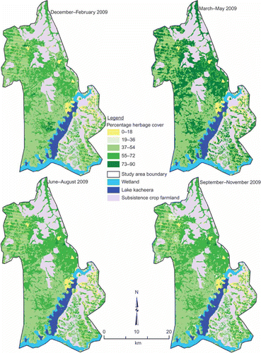
Grass cover data collection was based on Landsat TM image spectral strata. The number of strata was obtained based on experience from field reconnaissance and visual inspection of different combinations of 5, 4, 3 and 2 bands. The image was stratified into 10 spectral pattern cover classes using unsupervised classification in ERDAS IMAGINE 9.1. The classes (strata) were verified and modified using vegetation survey data from the field to ensure that sampling strata belonged to similar and realistic cover types in the field. Two of the cover classes were water and wetland. Eight other classes were used as the sampling strata for grass cover data collection. The grass cover data from the strata were collected using clustered random sampling (). Sampling sites were selected (clustered) in such way that a maximum number of strata were represented at a given data collection area (cluster) as a way of minimizing the time spent on movement between strata (Mueller-Dombos and Ellenberg Citation1974). All strata of minimum mapping size of 60 m × 60 m (16 pixels) or greater (Townshend Citation1983) were considered for grass cover sampling irrespective of their size. Sampling point locations for the grass cover were randomly selected and saved in a Garmin 12 Global Positioning System (GPS) for navigation during field data collection. For each stratum, at least 12 quadrats of 2 m × 2 m were placed every month from December 2008 to November 2009. In each quadrat, percent grass cover was estimated and recorded. Percentage cover estimates were done using calculated percentage cover charts (Kercher, Frieswyk, and Zedler Citation2003). Grass cover data for the different strata and months were averaged according to seasons (). The seasons used were December–February, March–May, June–August and September–November. For each season, the averaged grass cover percentages were used to assign grass cover classes to all the eight vegetation strata to come up with seasonal herbage cover maps ().
Table 1. Average seasonal grass cover
Figure 1. Image stratification and location of sampling sites in the different vegetation strata.
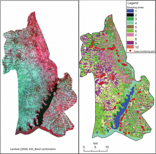
Figure 2. Spatial and seasonal patterns of herbage cover.
2.2.2. Rainfall data
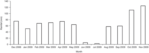
Fourteen rain gauge stations were set up in the study area. Recording of rainfall (in mm) was done every morning at 09:00 for the whole period of grass cover data collection. The rainfall for each station was computed for monthly () and seasonal totals (). The station seasonal rainfall data were interpolated using the spline tool in ArcGIS 9.3 to estimate rainfall values for every 30 m × 30 m grid on a map (ESRI Citation2010).
Table 2. Seasonal rainfall totals
Figure 3. Monthly rainfall distribution during the study period.
2.2.3. Soil and rainfall effectiveness data
Rainfall effectiveness was based on the premise that soil water availability for herbage growth at a given rangeland site is directly related to rainfall and water holding capacity properties of soil. During rainfall, water may infiltrate or percolate through the soil profile or run off the soil surface to be lost from a specific site depending on soil characteristics. Such differences are associated with differences in rainfall effectiveness (McGinty, Thurow, and Taylor Citation1991) and herbage production at a given location (Santos et al. Citation2003). In order to classify soils according to rainfall effectiveness groups, soil profiles were described following the standard methodology (FAO Citation1990). Sampling was based on strata resulting from GIS spatial overlay of the six FAO soil and two slope (%) classes (≤8.65 and >8.65). The source of elevation data for slope classes was a 90-m resolution digital elevation model derived from Shuttle Radar Topographic Mission . For each of the resulting 12 soil-slope combination strata, at least three sites were randomly sampled for soil profile description and soil sample collection for texture, hydraulic conductivity and bulk density determination in laboratory. Soil depth was described in the field as very shallow (0–15 cm), shallow (15–30 cm) or very deep (>30 cm) using mini-pits of 1 m × 1 m dug in each of the sampled strata. The laboratory samples were analysed using methods described by Okalebo, Gathua, and Woomer (Citation2002). The results were used to classify the FAO soil map units into soil drainage (rocky, poorly drained or well drained) categories. Combinations of soil profile and drainage classes were grouped into three soil physical groups () according to FAO (Citation1990) and assigned rainfall effectiveness factors as described by van Wijngaarden (Citation1985). The effectiveness factor for a soil map unit was an outcome of a combination of its drainage, slope and soil depth properties as determined above. Each soil map unit was subsequently assigned respective rainfall effectiveness value to come up with a rainfall effectiveness map. The higher the value of the effectiveness factor, the higher the level of expected herbage production.
Table 3. FAO soil physical groups and respective rainfall effectiveness factors
2.2.4. Grass mass from clipping
Quadrats of 1 m × 1 m were randomly laid at three locations of each of the eight sampling strata that were selected for grass cover measurements during the same month. Grass in the quadrats was harvested for above-ground DM determination. All residual litter and other non-grass plant materials were removed by hand picking from the harvest. The harvested fresh grass samples were oven dried at 60°C until constant weight. The weight of dry samples (in g-DM m−2) was recorded for the resulting 24 samples.
2.3. Herbage mass estimation
Seasonal grass mass was estimated from seasonal grass cover, rainfall and rainfall effectiveness factor. The estimations were done using the following equation by Toxopeus (Citation1999):
The relationships among the harvested grass above-ground DM and seasonal grass cover, rainfall and rainfall effectiveness were assessed using regression analysis with half of the quadrat clipping dataset. Before the analysis, all data were transformed using natural log function. Coefficients of variation from the regression were used to modify EquationEquation (1)(1) resulting in a new equation (EquationEquation (2)
(2)), which was also used for the estimations of herbage mass spatial and seasonal patterns.
The relationship between harvested and the estimated grass mass (DM) values at locations of quadrat clipping was evaluated using correlation analysis with the half of clipped DM dataset that was not used for regression analysis. The same dataset was used to test whether grass mass DM measurements from the quadrat harvesting method were significantly different from those estimated using a t-test.
The estimation equation variables were integrated using ModelBuilder in ArcGIS 9.3 (ESRI Citation2008) to come up with spatial and seasonal grass mass distributions. To establish the relationship between the estimated and harvested grass mass, a correlation analysis was done using Genstat discovery version software.
2.3.1. Sensitivity and uncertainty analysis
A stepwise approach to multi-linear regression analysis was used for model sensitivity analysis for the individual explanatory variables. Uncertainty was analysed based on root-mean-square errors (RMSEs) for the different variables using EquationEquation (3)(3).
3. Results
The highest amount of rainfall was during September–November season while the lowest was during June–August (, ). In contrast, grass cover was highest during March–May with the lowest cover during September–November (). The correlation analysis between the estimated and harvested grass mass (DM) using EquationEquation (1)(1) resulted in a very low correlation with an R
2 of 0.23.
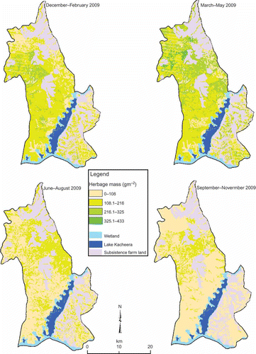
When transformed data were used, regression analysis of harvested DM with rainfall, grass cover and rainfall effectiveness resulted in an R 2 of 0.76 (p < 0.001). The coefficients used in grass mass estimation are shown in . Results of correlation analysis between estimated and harvested grass mass showed that there is a significant positive relationship (R 2 = 0.85) (). A t-test showed that there is no significant difference between estimated and measured DM (p = 0.5). The highest grass mass average estimate (1923 kg-DM ha−1) was during March–May season and the lowest was during September–November (895 kg-DM ha−1) (, ).
Table 4. Regression coefficients and statistics of rainfall, grass cover and rainfall effectiveness
Table 5. Seasonal grass mass yield
Figure 4. Correlation between estimated and measured herbage mass.
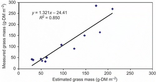
Figure 5. Seasonal and spatial distribution of herbage mass.
Results from stepwise multi-linear regression analysis showed that grass cover was the most important and significant variable for herbage mass estimation. It registered an R 2 value of 0.73 (p < 0.001) with harvested herbage mass. The regression results with rainfall and rainfall effectiveness were insignificant (). RMSEs from uncertainty analysis indicated that grass cover, rainfall and rainfall effectiveness were reliable predictors of herbage mass. The highest level of certainty was registered by grass cover ().
Table 6. Model sensitivity (R 2 and slope p-value) and uncertainty RMSEs
4. Discussion
Results of this study show that there is a consistent positive relationship between rainfall and grass cover. However, this relationship is associated with a consistent time lag in grass cover response to dry and wet seasons. Consequently, this relationship is translated into grass mass seasonal patterns. The lag can be explained by the time taken before rain effect on growth and the dry season effect on grass cover decline due to desiccation and grazing pressure. Whereas the September–November season received higher amounts of rainfall, it recorded the lowest herbage yields compared with June–August season, which was the driest season. The herbage mass during June–August was as a result of accumulated growth during the preceding March–May rainy season. Similarly, the June–August dry season effect was realized during the September–November season. The recovery effect of the September–November rains was realized during December–February season. Such seasonal patterns exhibited by the results are not only a reflection of the importance of rainfall seasons in determining herbage production (Schönbach et al. Citation2012) but also the influence of productivity conditions of soil, topographic conditions among other factors (Canton et al. Citation2003; Diaz-Solis et al. Citation2003).
The observed inter-seasonal herbage mass transition lag requires management measures that will optimize herbage utilization while minimizing the negative effects from grazing. Different rangeland sites have different rates of response to transition from dry or wet season and hence require different grazing management measures. Areas with longer time lag from dry to wet season are more susceptible to degradation and therefore need to be exposed to less grazing pressure, especially during the dry season, to minimize soil exposure to erosion and loss of soil moisture which may lead to rangeland retrogression (Ao et al. Citation2008). On the other hand, rangeland sites that take a shorter time to recover from dry seasons are less likely to be affected by grazing pressure. Such sites are usually areas of grazing concentration at the start of wet seasons. When not well managed, such grazing concentration may eliminate some herbage species that are sensitive to grazing pressure (Facelli and Springbett Citation2009) such as Themeda triandra (McIntyre, Heard, and Martin Citation2003). However, well managed and moderate grazing distribution at such stage may enhance herbage quality while maintaining high production and herbage cover as was noted by Osborne (Citation2000).
The 76% explanation of herbage mass patterns by the variables considered in this study indicates that the relationship among rainfall and grass cover offers a good estimator of herbage DM. Interestingly, this was comparable to other results that have been reported based on small cartographic scales for East Africa (Jama et al. Citation2003; Mulindwa et al. Citation2009). The determination coefficients were higher than what was reported in related studies for rangelands in Asia by Suzuki et al. (Citation2012) and Li Jianlong and Quangong (Citation1998). In Australia, an estimation model by Trnka et al. (Citation2006) explained 78% variability in harvested herbage DM production. Results from stepwise regression analysis with harvested DM yield indicated that grass cover measurements alone could explain 73% of herbage DM yield. Such a relationship shows that grass cover can reasonably be used as a proxy measurement of herbage mass.
The inclusion of rainfall and rainfall effectiveness in the equation improved the estimation of herbage mass, but the improvement was not significant. However, from uncertainty analysis, results indicated that all the variables considered were reliable predictors of herbage mass with grass cover having the lowest RMSE. The significant influence and reliability of grass cover underscores the importance of cover measurements in estimating herbage quantity and its distribution (Mueller-Dombos and Ellenberg Citation1974; Tueller Citation1993). With grass cover estimates based on satellite image spectral strata as used in this study, spatial and temporal herbage patterns can easily and accurately be monitored (Herlocker Citation1999).
The herbage mass seasonal trends exhibited by results of this study are related to the findings by Mulindwa et al. (Citation2009) in which they reported the highest carrying capacity during March–May season in the same area. The low herbage during September–November season due to the effect of June–August dry season poses productivity management challenges to livestock managers and users. While there was sufficient herbage during other seasons, many animals died at the end of the dry season in September 2009. Currently, the dry season response mechanisms to herbage scarcity by livestock owners involve selling of some of their animals to avoid death-related losses. Usually during such dry spells, there is overgrazing with most of rangeland sites left bare which has caused soil erosion, especially at the beginning of rainy seasons. If not well addressed, this cycle of events and processes is likely to continue reducing the productivity of the rangelands, compromise water quality and quantity due to sediment and nutrient loading in water bodies (NEMA Citation2007). One of the potential remedies is irrigation and increased watering points, but this will require financial investment in water distribution and storage infrastructure. Herbage conservation especially during March–May growing season to be used at the end of the dry season is another possible way of availing feed for animals. Moreover, most of the herbage is lost through trumpling during the growing season (Osborne Citation2000).
Whereas the estimations were based on the regression coefficients for one season, it is possible that differences might occur with clipping data from other seasons and more so in different years. For instance, December to February, which received relatively higher rainfall and considered a growing season in this study, has been reported to be drier in some years (Bloesch Citation2002). Therefore, the estimation procedures outlined in the study will have to change accordingly based on seasonal rainfall patterns.
5. Conclusions
The results of this study clearly indicated that rainfall and rainfall effectiveness were insignificant in the estimation of herbage yield. This study demonstrated that grass cover was the most important proxy measurement of spatial and seasonal patterns of rangeland herbage. DM predictions obtained using grass cover were not significantly different from those measured using the classical quadrat clipping method. Hence, herbage mass can in reality be monitored based on grass cover measurements to avoid or at least minimize the cost, destruction and information timeliness implications that are known to be associated with harvesting methods. Since the estimation method is reasonably accurate and eliminates the lengthy weighing and drying procedures, the intensity of data collection for monitoring can be increased tremendously to ensure regular and more precise updates on rangeland productivity conditions. It was, therefore, recommended that the approach described in this study can be adopted and up-scaled for herbage mass estimations in Uganda. Moreover, the method can potentially be easily adopted by ordinary farmers with fewer and cheaper materials through training. However, it should be noted that the estimation procedures could be improved with seasonal-specific prediction equations which should be regularly updated whenever there are drastic shifts in rangeland conditions.
References
- Ao , M. , Ito , M. , Ito , K. , Yun , J. F. , Miura , R. and Tominaga , T. 2008 . Floristic Compositions of Inner Mongolian Grasslands Under Different Land-Use Conditions . Grassland Science , 54 ( 4 ) : 173 – 178 .
- Beeri , O. , Phillips , R. , Hendrickson , J. , Frank , A. B. and Kronberg , S. 2007 . Estimating Forage Quantity and Quality Using Aerial Hyperspectral Imagery for Northern Mixed-Grass Prairie . Remote Sensing of Environment , 110 ( 2 ) : 216 – 225 .
- Bloesch , U. 2002 . “The Dynamics of Thicket Clumps in the Kagera Savanna Landscape, East Africa”. PhD thesis (No. 14386) , Shaker, Aachen , DE : Swiss Federal Institute of Technology Zurich (ETH) .
- Canton , Y. , Del Barrio , G. , Sole-Benet , A. and Lazaro , R. 2003 . Topographic Controls on the Spatial Distribution of Ground Cover in the Tabernas Badlands of SE Spain . CATENA , 55 : 341 – 365 .
- Castillo , E. , Valles , B. , Jarillo , J. and Ocaña , E. 2009 . Pasture Height Distribution of Grazed Tropical Native Grammas in Veracruz State, Mexico . Grassland Science , 55 ( 3 ) : 140 – 148 .
- de Ridder , N. and Breman , H. 1993 . “ A New Approach to Evaluating Rangeland Productivity in Sahelian Countries ” . In Range Ecology at Disequilibrium: New Models of Natural Variability and Pastoral Adaptation in African Savannas , Edited by: J. R. H. , Behnke , I. , Scoones and C. , Kerven . 104 – 117 . London : Overseas Development .
- Diaz-Solis , H. , Kothmann , M. M. , Hamilton , W. T. and Grant , W. E. 2003 . A Simple Ecological Sustainability Simulator (SESS) for Stocking Rate Management on Semi-Arid Grazinglands . Agricultural Systems , 76 ( 2 ) : 655 – 680 .
- ESRI . 2008 . ArcGIS 9. 9.3 , Redlands , , CA : Environmental Systems Research Institute .
- ESRI . 2010 . ESRI ArcMap 10.0. 10.0 , Redlands , CA : Environmental Systems Research Institute .
- Facelli , J. M. and Springbett , H. 2009 . Why Do Some Species in Arid Lands Increase Under Grazing? Mechanisms that Favour Increased Abundance of Maireana Pyramidata in Overgrazed Chenopod Shrubs of South Australia . Austral Ecology , 34 : 588 – 597 .
- FAO . 1990 . Guidelines for Soil Description , Rome : FAO .
- Fujita , N. , Amartuvshin , N. , Yamada , Y. , Matsui , K. , Sakai , S. and Yamamura , N. 2009 . Positive and Negative Effects of Livestock Grazing on Plant Diversity of Mongolian Nomadic Pasturelands along A Slope with Soil Moisture Gradient . Grassland Science , 55 ( 3 ) : 126 – 134 .
- Herlocker , D. J. 1999 . Rangeland Ecology and Resource Development in Eastern Africa , Nairobi : German Agency for Technical Co-Operation .
- Jama , A. , Kingamkono , M. , Mnene , W. , Ndungu , J. , Mwilawa , A. , Sawe , J. Byenkya , S. 2003 . “ A Satellite-Based Technology Predicts Forage Dynamics for Pastoralists ” . In Global Livestock Collaborative Research Support Program , Research Brief 03-03-LEWS .
- Kercher , S. M. , Frieswyk , C. B. and Zedler , J. B. 2003 . Effects of Sampling Teams and Estimation Methods on the Assessment of Plant Cover . Journal of Vegetation Science , 14 : 899 – 906 .
- Li Jianlong , T. L. and Quangong , C. 1998 . Estimating Grassland Yields Using Remote Sensing and GIS Technologies in China . New Zealand Journal of Agricultural Research , 41 : 31 – 38 .
- Liang , T. and Chen , Q. 1999 . Applications of GIS and Remote Sensing Technologies on Grassland Monitoring and Management in China . Geoinformatics and Socioinformatics. The Proceedings of Geoinformatics ’99 Conference, Ann Arbor, MI , June 19–21 : 1 – 13 . Association of Chinese Professionals in GIS
- Martin , R. C. , Astatkie , J. M. and Fredeen , A. H. 2005 . A Comparison of Methods Used to Determine Biomass on Naturalized Swards . Journal of Agronomy and Crop Science , 191 : 152 – 160 .
- McGinty , A. , Thurow , T. L. and Taylor , C. A. 1991 . Improving Rainfall Effectiveness on Rangeland . Texas Agricultural Extension Bulletin , L-5029 : 6
- McIntyre , S. , Heard , K. M. and Martin , T. G. 2003 . The Relative Importance of Cattle Grazing in Subtropical Grasslands: Does It Reduce or Enhance Plant Biodiversity? . Journal of Applied Ecology , 40 ( 3 ) : 445 – 457 .
- MoLHU , D . 2007 . The National Land Use Policy , Kampala: MoLHUD . (Ministry of Lands, Housing and Urban Development)
- Moreau , S. , Bosseno , R. , Gu , X. F. and Baret , F. 2003 . Assessing the Biomass of Andean Bofedal and Totora High-Protein Wetland Grasses from NOA/AVHRR . Remote Sensing of Environment , 85 : 516 – 529 .
- Mueller-Dombos , D. and Ellenberg , H. 1974 . Aims and Methods of Vegetation Ecology , Toronto, ON: John Wiley & Sons .
- Mulindwa , H. , Galukande , E. , Wurzinger , M. , Mwai , O. A. and Sölkner , J. 2009 . Modelling of Long Term Pasture Production and Estimation of Carrying Capacity of Ankole Pastoral Production System in South Western Uganda . Livestock Research for Rural Development , 21 ( 9 ) “”Accessed date March 23, 2011. http://www.lrrd.org/lrrd21/9/cont2109.htm; http://www.lrrd.org/lrrd21/9/muli21151.htm
- NEMA . 2007 . State of Environment Report for Uganda , Kampala : NEMA . (National Environment Management Authority)
- Okalebo , J. R. , Gathua , K. W. and Woomer , P. L. 2002 . Laboratory Methods of Soil and Plant Analysis: A Working Manual , Nairobi : Tropical Soil Biology and Fertility Programme. Marvel EPZ, Kenya Press .
- Okello , S. , Sabiiti , E. N. and Schwartz , H. 2005 . Factors Affecting in sacco Dietary Degradation by Ankole Cattle Grazing Natural Range Pastures in Uganda . African Journal of Range and Forage Science , 22 ( 3 ) : 157 – 165 .
- Osborne , P. L. 2000 . Tropical Ecosystems and Ecological Concepts , Cambridge : Cambridge University Press .
- Price , K. P. , Guo , X. and Stiles , J. M. 2002 . Optimal Landsat TM Band Combinations and Vegetation Indices for Discrimination of Six Grassland Types in eastern Kansas . International Journal of Remote Sensing , 23 ( 11 ) : 5031 – 5042 .
- Reeves , M. C. , Winslow , J. C. and Running , S. W. 2001 . Mapping Weekly Rangeland Vegation Productivity using MODIS Algorithms . Journal of Range Management , 54 : A90 – A105 .
- Reeves , M. C. , Zhao , M. and Running , S. W. 2006 . Applying Improved Estimates of MODIS Productivity to Characterise Grassland Vegetation Dynamics . Journal of Rangeland Ecology and Management , 59 ( 1 ) : 1 – 10 .
- Roy , P. S. and Ravan , S. A. 1996 . Biomass Estimation using Satellite Remote Sensing Data – An Investigation on the Possible Approaches for Natural Forest . Journal of Bioscience , 21 ( 4 ) : 535 – 561 .
- Santos , F. L. , Reis , J. L. , Martins , O. C. , Castanheira , N. L. and Serralheiro , R. P. 2003 . Comparative Assessment of Infiltration, Runoff and Erosion of Sprinkler Irrigated Soils . Biosystems Engineering , 86 ( 3 ) : 355 – 364 .
- Schönbach , P. , Wan , H. , Gierus , M. , Loges , R. , üller , K. M , Lin , L. , Susenbeth , A. and Taube , F. 2012 . Effects of Grazing and Precipitation on Herbage Production, Herbage Nutritive Value and Performance of Sheep in Continental Steppe . Grass and Forage Science , 67 : 535 – 545 .
- Suzuki , Y. , Okamoto , H. , Takahashi , M. , Kataoka , T. and Shibata , Y. 2012 . Mapping the Spatial Distribution of Botanical Composition and Herbage Mass in Pastures Using Hyperspectral Imaging . Grassland Science , 58 ( 1 ) : 1 – 7 .
- Teague , W. R. and Foy , J. K. 2002 . Validation of SPUR2.4 Rangeland Simulation Model using A Cow-calf field Experiment . Agricultural Systems , 74 ( 2 ) : 287 – 302 .
- Townshend . 1983 . “Effects of Spatial Resolution on the Classification of Land Cover Type.” In ” . In Ecological Mapping from Ground, Air and Space , Edited by: Fuller , R. M. 101 – 112 . ITE, Monks Wood Experimental Station, Abbots Ripton, Huntingdon: Institute of Terrestrial Ecology . J. R. G.
- Toxopeus , A. G. 1999 . An Interactive Spatial and Temporal Modelling System as a Tool in Ecosystem Management , 2nd , Enschede: ITC .
- Trnka , M. , Eitzinger , J. , Gruszczynski , G. , Buchgraber , K. , Resch , R. and Schaumberger , A. 2006 . A Simple Statistical Model for Predicting Herbage Production from Permanent Grassland . Grass and Forage Science , 61 ( 3 ) : 253 – 271 .
- Tueller , P. T. 1993 . Vegetation Science Application for Rangeland Analysis and Management , Dordrecht : Kluuwer Academic Publishers .
- van Wijngaarden , W. 1985 . Elephants – Trees – Grass – Grazers; Relationships between Climate, Soils, Vegetation and Large Herbivores in a Semi-Arid Savanna Ecosystem (Tsavo, Kenya) , Enschede : International Institute for Aerospace Survey and Earth Sciences (ITC) .
- Vermeire , L. T. and Gillen , R. L. 2001 . Estimating Herbage Standing Crop with Visual Obstruction in Tallgrass Prairie . Journal of Range Management , 54 ( 1 ) : 57 – 60 .
- Woodward , S. J. R. , Wake , G. C. and McCall , D. G. 1995 . Optimal Grazing of a Multi-Paddock System Using a Discrete Time Model . Agricultural Systems , 48 ( 2 ) : 119 – 139 .
- Zhang , B. , Valentine , I. , Kemp , P. and Lambert , G. 2006 . Predictive Modelling of Hill-pasture Productivity: Integration of a Decision Tree and a Geographical Information System . Agricultural Systems , 87 ( 1 ) : 1 – 17 .