
ABSTRACT
Microwave satellite data enable the mapping of flooding over large areas, irrespective of cloud and weather conditions. Efficient planning of microwave data for acquiring satellite images over flood-affected areas for flood assessment and mapping needs prior information about the probable flood areas. Analysis of rainfall trend over a particular region over a time can help in predicting the flood-like situation and probable flood areas. Forecasts from weather forecasts models provide a fair idea about high rainfall events. Integration of global rainfall products (Tropical Rainfall Measuring Mission (TRMM)) and global forecast precipitation products (Global Ensemble Forecast System (GEFS)) can help in identifying the probable areas which may attain high rainfall. This advance information about probable high rainfall areas can be used in planning the remote sensing satellites for acquiring the satellite imagery over the area for flood mapping activities. Temporal satellite images integrated with disaster news available on Internet can help in analysing the ground situation (residing or increasing of flood situation). It can help in resource planning and management. The main purpose of this study is to develop a GIS-based framework coupled with automatic procedures for integrating TRMM, GEFS and disaster news using open-source technologies to identify the probable high rainfall area over Indian region and its application in planning acquisition of microwave satellite data sets for flood mapping activities. The high rainfall events identified using TRMM, GEFS and disaster news have been verified with Indian Metrological Department rainfall data during Chennai floods 2015 and Assam floods 2016. The system has been successfully used to plan and acquired satellite data for flood season 2015 and 2016.
KEYWORDS:
1. Introduction
Flood is one of the most destructive natural disasters, which causes more economic loss than other natural or technological disasters (Huang et al. Citation2008). India, one of the tropical countries, has the greatest problem of being severely affected by floods mainly caused by heavy rains in monsoon season (Sharma et al. Citation1996). Sensors like, Tropical Rainfall Measuring Mission (TRMM) Multisatellite Precipitation Analysis (TMPA) provides a calibration-based sequential scheme for combining precipitation estimates from multiple satellites, as well as gauge analyses where feasible, at fine scales (0.25 × 0.25 and 3-hourly). TMPA is available both after and in real time, based on calibration by the TRMM Combined Instrument and TRMM Microwave Imager precipitation products, respectively (Huffman et al. Citation2007). The TRMM launched in late November 1997, with a design lifetime of 3 years still gives observed 3-hourly Global rainfall data (http://trmm.gsfc.nasa.gov/affinity/affinity_3hrly_rain.html). Nicholson et al. (Citation2003) in his study has validated TRMM and other rainfall estimates with high-density gauge data sets. They successfully carried this study for West Africa. Mitra et al. (Citation2013) have merged the TRMM data with rainfall data of 14 monsoon seasons collected from ground using Indian Metrological Department (IMD) Gauge stations to generate gridded daily Indian monsoon rainfall. Researchers have successfully used TRMM products for soil moisture prediction, dry/wet conditioning monitoring, risk assessment, extreme rainfall characterization and hydrological modelling (Gupta et al. Citation2014; Li, Zhang, and Ye Citation2013; Dinis et al. Citation2013; Bernardi et al. Citation2015; Liu et al. Citation2015; He et al. Citation2017; Robbins Citation2016; Cabrera, Yupanqui, and Rau Citation2016). The above-mentioned studies proved the potential of TRMM data usage for high rainfall event detection. Continues analysis and monitoring of the rainfall trends provided by TRMM can predict the extreme rainfall events.
Flood caused by extreme rainfall events can be mapped using remote sensing data. Remote sensing has a key function now in the assessment and monitoring of natural disasters. Optical images were used before to distinguish flooded and non-flooded area by Rao et al. (Citation1998) and Jain et al. (Citation2006). Near-infrared part of the electromagnetic spectrum is absorbed by the waterbodies, and it appears dark in infrared satellite imagery which is useful to delineate the flood (Sanyal and Lu Citation2003); but in the cloudy atmosphere, it is difficult to map the flooded area using optical imagery. Radar signals can penetrate the weather phenomena and are very useful for flood delineation (Matgen et al. Citation2007). Due to limited number of microwave sensors and there prescheduled orbits, it is needed to programme the satellite passes to acquire images over the effected region, well in advance.
Advance satellite planning needs information of areas which are currently receiving heavy rains and may attain flood-like situation. Global observed rainfall data providers like TRMM can be used to identify the probable flood areas. Using TRMM observed rainfall data alone as a high rainfall indicator may not serve the purpose of identifying probable flood areas in advance as the service is not real time and the rainfall data will be available for analysis after a time delay. Integration of forecasts issued by weather forecasts models can fulfil this gap. Global Ensemble Forecast System (GEFS) is a weather forecast model made up of 21 separate forecasts, or ensemble members used to address the nature of uncertainty in weather observations, which is used to initialize weather forecast models (https://www.ncdc.noaa.gov/data-access/model-data/model-datasets/global-ensemble-forecast-system-gefs). Shah and Mishra (Citation2016) have used the GEFS products for short-term drought prediction in India and successfully demonstrated its accuracy for predicting natural disasters. Liu et al. (Citation2006) has used the GEFS products for predicting Hurricane track.
Integration of observed TRMM rainfall products with global forecast precipitation products (GEFS) can help in analysing the current as well as future rainfall scenario which may cause flood situation. Combination of TRMM and GEFS products enhanced the accuracy of the system. Integrated global TRMM and GEFS products can be customized for identifying the high rainfall events/areas over a region. As the TRMM and GEFS products are global in nature, customized products for a region may miss the localized high rainfall events. For the purpose of validation, verification and identification of the areas affected by high rainfall, we depend upon the reported news/information from ground. Various news channels and newspapers are providing their live newsfeeds on Internet in Rich Site Summary or Really Simple Syndication (RSS) and Geo RSS formats. Sharma et al. (Citation2016) have proposed a framework in which they have used observed TRMM data to generate the probable flood events. The developed system is generating current-day, past 1-day, 2-day and 3-day products over Indian region using TRMM data. The system can be upgraded by integrating the global forecast precipitation products (GEFS). It will increase the time frame window of current-day and past 3 days products to past 3 days, current-day and future 3 days products. By considering Sharma et al. (Citation2016) as a base work, this study has been proposed to generate automated integrated TRMM and GEFS spatial products coupled with live news available as rich site summary (RSS) feeds using open-source technologies to identify probable high rainfall events over Indian region, on which the satellite data can be planned for acquisition. The satellite data planned using the above method can be used for delineating flood using GIS software and techniques.
By considering Sharma et al. (Citation2016) as a base work, this study has been proposed with following design objectives:
Customization of global TRMM observed rainfall and GEFS forecasted rainfall products for generating local rainfall products.
Identification of probable flood events by integrating TRMM observed rainfall; GEFS forecasted rainfall and disaster news using open-source technologies.
Feasibility study of utilizing probable flood event information for advance satellite data planning and acquisition for flood mapping activities.
2. Workflow and open-source technologies used
The TRMM and GEFS 3-hourly Global rainfall data are freely available for download at a FTP(ftp://disc2.nascom.nasa.gov/data/TRMM/Gridded/Derived_Products/3B42RT/Daily/2016/for TRMM and ftp://ftp.cdc.noaa.gov/Projects/Reforecast2/2016 for GEFS). shows the detailed procedure implemented in developing the system. The main steps include:
Figure 1. Work flow.
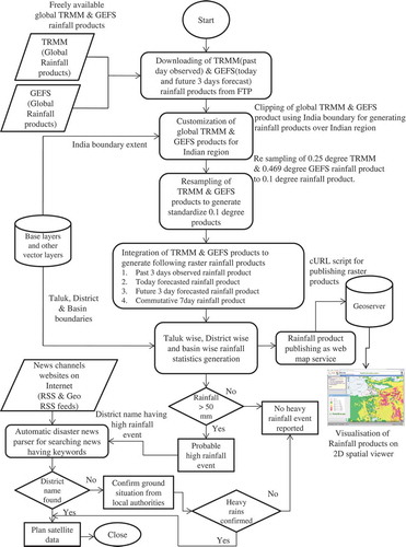
Step 1: Downloading and organization of global TRMM and GEFS rainfall product: The TRMM and GEFS global rainfall data have been downloaded and organized into postgreSQL (RDBMS) using automatic scripts developed in java.
Step 2: Customization of global rainfall products over Indian region: Software program in R environment has been developed to customize the global rainfall products over Indian region by clipping the rainfall products using Indian boundaries.
Step 3: Resampling of TRMM and GEFS rainfall data for common resolution: The TRMM and GEFS data have different resolutions of 0.25° and 0.469° and hence cannot be merged together dynamically. The TRMM and GEFS data have been resampled into 0.1° data, suitable for Indian taluks and districts using R.
Step 4: Commutative rainfall product generation: The resampled data have been used to generate past 03 days, today, future 03 days and commutative 07 days rainfall products using R procedures. Past 03-day rainfall product has been generated by adding the past 03-day observed TRMM data. GEFS forecasted data for today and future 03 days have been used to generate current-day rainfall product and forecasted 03-day rainfall products, whereas commutative 07-day rainfall product has been generated by adding past 03-day, today and future 03-day rainfall products. The rainfall products have been generated in netCDF(.nc) file format.
Step 5: Rainfall Statistics generation: Zonal statistics functions of R has been used to calculate taluk-wise, district-wise and basin-wise rainfall calculation.
Step 6: Publishing of rainfall products as web map service (WMS): The spatial products have been automatically published as WMS and integrated into 2D spatial viewer using cURL, GeoServer and javascript.
Step 7: Identification of probable high rainfall event location: Districts attaining rainfall above 50 mm have been identified and categorized into moderate, high and very high rainfall places:
Step 8: Disaster new extraction: An automatic web parser for extracting disaster-related news from RSS and Geo RSS of news website has been developed in php. It searches the news RSS for a set of keywords like heavy rains, flood for the high rainfall districts identified from TRMM and GEFS. The disaster news and the rainfall products are integrated together to identify the probable high rainfall event locations.
Step 9: Satellite data planning: The information of high rainfall event derived using the system has been used to plan the remote sensing satellite data which further used for flood mapping activity.
2.1. TRMM products to generate past 03 days commutative rainfall products
Automatic scripts in java have been programmed to download data from TRMM and GEFS website. As the TRMM data provide the observed rainfall and comes with a time lag, it has been used to show the previous day rainfall. TRMM products are used to generate:
1. Past 03 days cumulative rainfall products
Every day the automatic scripts download the previous day global merged observed rainfall product in Netcdf(.nc) format and organize it in open-source relational database PostgreSQL for further processing. Subsequently, latest past 3 days TRMM data sets have been used to generate past 3 days commutative rainfall products.
2.2. Global Ensemble Forecast System (GEFS) products to generate today’s and future 3 days rainfall products
GEFS forecasted rainfall products have been used to generate:
Today’s forecasted rainfall product
Future 03 days forecasted rainfall products
Weekly products (07 days), by integrating past 03 days observed rainfall (from TRMM), today’s forecasted rainfall and future 03 days forecasted rainfall products (from GEFS).
2.3. Processing of TRMM and GEFS product using R
The global TRMM and GEFS products have been downloaded and customized for Indian region using automated scripts developed in R language. R is a language and environment for statistical computing and graphics. It is a GNU open-source project used for data manipulation, calculation and graphical display (https://www.r-project.org/about.html). For customizing the products, the following steps have been implemented.
2.3.1. Clipping global products for obtaining rainfall over Indian region
The global TRMM and GEFS products have been clipped over the Indian region. R clip {graphics} where graphics are user defined coordinates (x1, x2, y1, y2 i.e. bounding box) used to clip the raster in rectangle.
2.3.2. Resampling of TRMM and GEFS product
The rainfall products over Indian region were resampled in the next step. There are different methods which can be used to resample raster data like:
Nearest-neighbour resampling technique
Bilinear interpolation
Cubic convolution
Each one is having its own advantage; Karlsson and Yakowitz (Citation1987) have successfully used methods based on nearest-neighbour resampling techniques for non-parametric rainfall–runoff forecasting. Also, nearest-neighbour resampling technique gives better results for categorical data like land use, non-parametric rainfall estimation and other classifications. With these advantages, we have used the nearest-neighbour resampling techniques. In this, each cell in the new raster is assigned the value of the nearest cell (centre to centre) in the original raster.
As TRMM provides the products in 0.25°* 0.25° and GEFS in 0.469° * 0.469° resolution, both the products cannot be merge directly. Hence, a common resolution has to be used to resample the products. Several districts of states in India are having less area, to standardize the product 0.1° * 0.1° grids has been chosen. In the resampling process, the TRMM and GEFS products have been resampled to 0.1° * 0.1° grids.
2.3.3. Products generation
After resampling, predefined thresholds have been applied to the rainfall data to generate the following products in NetCDF formats identifying the high rainfall areas over Indian region:
TRMM past 03 days commutative observed rainfall product
GEFS today rainfall forecasted product
GEFS future 03 days commutative rainfall products
TRMM GEFS past 03 days and future 04 days commutative products
The rainfall has been classified in five different classes depending up on the intensity as shown in to generate the rainfall products. The 03 days rainfall products have been used to identify the locations which have received a high rainfall in last 03 days. The daily rainfall has been added to generate the 03-day product, if a district/area is receiving high rains from last 03 days, it is very much possible that it may get flood-like situation. Whereas the 07 days rainfall product, generated by integrating 03-day GEFS forecast, has been used to identify the areas which may not receive the high rainfall in past 03 days, but may receive high rainfall in next 03 days. Both 03-day and 07-day products have been considered for identifying the probable high rainfall areas over which the satellite data can be planned for acquisition.
Table 1. Rainfall classes.
2.3.4. Statistics generation
For better management, India is having multilevel administrative structure. Within a state, there is generally a four-tier structure of administration – state, district, taluk/tehsil/block and village. For better disaster management, the central government has established state disaster management authorities, which further has district disaster management plans to be executed for the relief and rescue operation on ground. In addition, there are major basin river authorities (like Ganga River basin authority) responsible for development and other processes in the basin area. To facilitate execution of disaster management plan by state disaster management and basin management authorities, rainfall statistics at different level is needed. The rainfall statistics has been provided to district authorities. Hence, once the rainfall products have been generated, the products have been integrated with base layers of India to generate zonal statistics at:
Taluk level
District level
Basin level
2.3.5. Products for publishing and downloading
The rainfall statistic has been integrated and rainfall products over Indian region showing taluks, districts and basins attaining commutative rainfall in mm have been available for download in pdf format as well as the same has been automatically published as WMS using cURL and GeoServer. An open-source 2D GIS viewer using open layers has been developed with a query builder to show the rainfall products in spatial domain.
2.3.6. Automatic disaster news extraction
Automatic scripts in PHP has been developed parsing the live RSS and GeoRSS from leading national newspapers and news channels for extracting the disaster-related news hosted on the websites. A repository of keywords (like flood, cyclone, heavy rains, etc.) to identify probable disaster news has been organized in database. The repository has been continuously updated with the type of disaster news published on the news sites. The news has been parsed with the keywords, if found the match the same will be organized in database and published as a point (if it is GeoRSS).
The information about the probable high rainfall areas over Indian region (district/taluk) has been extracted using TRMM and GEFS products. To further verify the high rainfall areas, an open-source news parser has been developed. The open-source news parser fetches the RSS and GeoRSS live feeds from news websites to fetch disaster specific news over Indian region. Comparison of local news and high rainfall products provides a clear idea about the situation on ground. This procedure helps in identifying the probable high rainfall areas. This high rainfall information is utilized to plan the satellite data sets well in advance over the rainfall affected area. Further, the remote sensing images acquired were analysed for flood mapping activities.
3. Results
To manage multiple flood events at same time, remote sensing images would be the best option. Analysing the temporal satellite images can easily identify the extent and current flood situation. Less number of available satellites could be a bottleneck in programming multiple events as they may not cover all the areas. The limited number of satellites available for acquiring the ground images can be efficiently utilized, if they can be programmed in advance. The usage of TRMM and GEFS products integrated with disaster news provides fair idea about the probable areas attaining high rainfall, hence using it, scientists can manage programming of satellites for image acquisition and flood mapping.
3.1. High rainfall maps generation
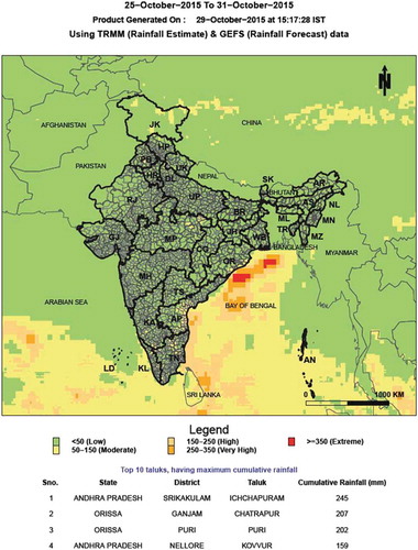
As explained in Section 2, TRMM and GEFS global rainfall data have been downloaded and customized to generate taluk/district-wise past 03 days commutative, today, future 03 days and 07 days commutative rainfall maps. Automated script in R language has been developed, taking TRMM and GEFS product and generating taluk-wise rainfall maps with taluk-wise and districts-wise rainfall. shows a sample 07 days commutative high rainfall taluk map generated on 29 October 2015 showing rainfall from 25 October 2015 to 31 October 2015.
Figure 2. 7 Days commutative high rainfall taluk map.
The rainfall products in raster format have been published as WMS for integrating in spatial viewer.
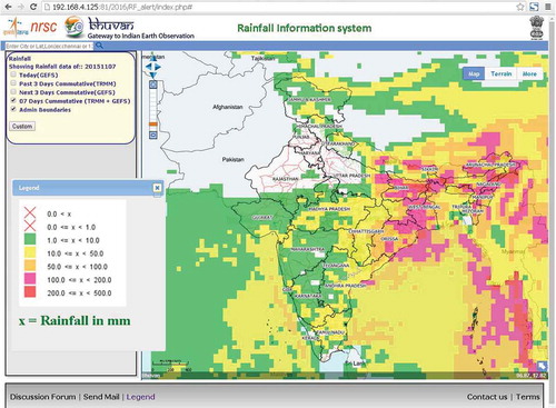
3.2. Spatial viewer for visualizing rainfall products
The raster products (NetCDF format) generated using R script have been automatically catalogued and published as a WMS using cURL, javascript and GeoServer. To view the rainfall products, a spatial viewer is needed. Openlayers 2.0 open-source API has been used to develop a thin client web-based 2D spatial viewer. Basic GIS functionalities like zoom in, zoom out and pan have been implemented using javascript and open layers. A query builder using AJAX, javascript and JQuery has been developed and integrated into the spatial viewer facilitating user to integrate the rainfall products by selecting the date from query builder. shows a sample 07 days commutative high rainfall products of 07 November 2015 on spatial viewer. User can select any date to view 03 days commutative, today, future 03 days and 07 days commutative rainfall maps.
Figure 3. Rainfall products showing deep depression on 7 November 2015.
3.3. Satellite data planning based on rainfall products: Chennai floods (2015) and Bihar floods (2016) – a case study
High rainfall areas reported using customized global TRMM and GEFS product can be used in identifying probable areas which can attain flood-like situation. Satellite data can be planned over the areas for which the rainfall products have given alerts. The accuracy of the system for forecasting can be tested on the basis of two parameters:
Event location
Rainfall attained
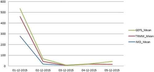
To test the accuracy of the system for forecasting the high rainfall events, a case study for flood occurred due to heavy rains in Chennai (December 2015) and Assam (July 2016) has been attempted. The rain fall values (in mm) recorded using IMD gauge stations have been compared with rainfall values obtained from TRMM and GEFS products.
Northeast monsoon during October to December causes rains in Southern States of India. Cuddalore, Chidambaram and Chennai received heavy rainfall due to Northeast monsoon during November–December 2015. shows the comparison of daily rainfall (mean) obtained from IMD, TRMM and GEFS for the period of 01–5 December 2015 over Chennai. The graph clearly indicated the same rainfall trend across the 03 different rainfall sources.
Figure 4. Comparison of rainfall obtained from IMD, TRMM and GEFS for Chennai flood.
Further, the accuracy has been tested for the heavy rains in Assam during the period of 25–31 July 2016. shows the comparison of rainfall obtained from IMD with TRMM and GEFS for Assam 2016 floods.
Figure 5. Comparison of rainfall obtained from IMD, TRMM and GEFS for Assam flood.
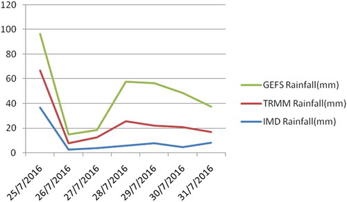
and clearly indicate the matching trend of observed rainfall from ground collected using IMD with rainfall obtained from TRMM and GEFS. Although, it has been observed that there is a difference between the ground values of rainfall obtained from IMD gauge stations and TRMM/GEFS rainfall value, but it has been successful to figure out the event locations. Flood mapping process using remote sensing satellite data sets needs to acquire satellite data over an effected area which usually is a large area. We generally use RISAT-1 and RADARSAT-2 data in Scan SAR Wide mode for flood mapping, which is having a approximately a scene size of 220 * 220 for RISAT 1 and 500 * 500 km for RADARSAT 2 data on ground. The area covered in the scene is large enough to remove the positional accuracy dependency. Hence, acquisition of satellite data over an area based on high rainfall events given by this system is acceptable.
In addition of event positional accuracy, the rainfall accuracy can be improved by categorizing the rainfall into broad classes indicating low, moderate, high, very high and extreme rainfall events.
Locations attaining rainfall above and equivalent to moderate class may give rise to flood-like situation hence needs to plan satellite data sets over it. Comparison of the rainfall for the above-mentioned 02 events gives an accuracy of more than 70% for forecasting. As the forecasting events derived using TRMM, GEFS and disaster news are used for advance satellite data planning only to fulfil flood mapping activities requirement, hence can be accepted.
Based on forecasted rainfall products, advance satellite data have been successfully planned over Chennai(2015) and Assam (2016) for flood mapping activities and value-added flood products have been generated, hosted on BHUVAN (http://bhuvan noeda.nrsc.gov.in/disaster/disaster/disaster.php).
4. Conclusion
Value-added flood products derived using satellite imageries showing flood extents can be used for disaster management. Advance information about probable flooded areas can help scientists to plan the satellites acquisition in advance, hence minimizing possibility of missing flood events for mapping. Floods caused by heavy rains can be predicted well in advance using earth’s precipitation products. TRMM and GEFS rainfall products providing global observed and forecasted rainfall can be customized and used to identify local high rainfall events. The identified high rainfall events can be counter verified with disaster news available on Internet. Open-source GIS software has the potential of generating the detailed rainfall products by using global rainfall products. Automatic procedures developed to generate high rainfall events along with detail statistics of districts/taluks/basins attaining high rainfall can be helpful in planning relief and rescue operations on ground by disaster managers along with advance satellite data planning.
To test the potential of the rainfall products and its usage in planning the satellite imagery for flood mapping, different rainfall products generated during Chennai floods (2015) and Bihar floods (2016) have been analysed. The comparison of the daily products clearly indicates the probable high rainfall events. Advance information about the events has been utilized in programming the satellites, images acquired have been utilized to generate the flood maps showing flood extent.
Acknowledgements
We thank Dr. Y.V.N. Krishna Murthy (Director NRSC) for providing the continues guidance throughout the process. We are grateful to Dr. V.K Dadhwal and Dr. P. G Diwakar for their guidance and support. Special thanks to Dr. M.V. Ravikumar, Dr. Vinod M Bothale, Mr. Arulraj. M and colleagues at the Disaster Management Support Group for support and cooperation; the TRMM and GEFS project team, for real-time and forecasted rainfall products.
Disclosure statement
No potential conflict of interest was reported by the authors.
References
- Bernardi, E. S., D. Allasia, R. Basso, P. F. Ferreira, and R. Tassi. 2015. “TRMM Rainfall Estimative Coupled with Bell (1969) Methodology for Extreme Rainfall Characterization.” Proceedings IAHS 369: 163–168. doi:10.5194/piahs-369-163-2015.
- Cabrera, J., R. T. Yupanqui, and P. Rau. 2016. “Validation of TRMM Daily Precipitation Data for Extreme Events Analysis. the Case of Piura Watershed in Peru.” Procedia Engineering 154: 154–157. doi:10.1016/j.proeng.2016.07.436.
- Dinis, P. A., V. Mantas, P. S. Andrade, J. Tonecas, E. Kapula, A. Pereira, and F. S. Carvalho. 2013. “Contribution of TRMM Rainfall Data to the Study of Natural Systems and Risk Assessment. Cases of Application in SW Angola.” Estudos Do Quaternário/Quaternary Studies 9: 25–35.
- Gupta, M., P. K. Srivastava, T. Islam, and A. M. B. Ishak. 2014. “Evaluation of TRMM Rainfall for Soil Moisture Prediction in a Subtropical Climate.” Environmental Earth Sciences 71 (10): 4421–4431. doi:10.1007/s12665-013-2837-6.
- He, Z., H. Hu, F. Tian, G. Ni, and Q. Hu. 2017. “Correcting the TRMM Rainfall Product for Hydrological Modelling in Sparsely-Gauged Mountainous Basins.” Hydrological Sciences Journal62 (2): 306–318.
- Huang, X., H. Tan, J. Zhou, T. Yang, A. Benjamin, S. W. Wen, S. Li, et al. 2008. “Flood Hazard in Hunan Province of China: An Economic Loss Analysis.” Natural Hazards 47: 65–73. doi:10.1007/s11069-007-9197-z.
- Huffman, G. J., D. T. Bolvin, E. J. Nelkin, D. B. Wolff, R. F. Adler, G. Gu, Y. Hong, K. P. Bowman, and E. F. Stocker. 2007. “The TRMM Multisatellite Precipitation Analysis (TMPA): Quasi-Global, Multiyear, Combined-Sensor Precipitation Estimates at Fine Scales.” Journal of Hydrometeorology 8 (1): 38–55. doi:10.1175/JHM560.1.
- Jain, S. K., A. K. Saraf, A. Goswami, and T. Ahmad. 2006. “Flood Inundation Mapping Using NOAA AVHRR Data.” Water Resources Managed 20: 949–959. doi:10.1007/s11269-006-9016-4.
- Karlsson, M., and S. Yakowitz. 1987. “Nearest‐Neighbor Methods for Nonparametric Rainfall‐Runoff Forecasting.” Water Resources Research 23 (7): 1300–1308. doi:10.1029/WR023i007p01300.
- Li, X., Q. Zhang, and X. Ye. 2013. “Dry/Wet Conditions Monitoring Based on TRMM Rainfall Data and Its Reliability Validation over Poyang Lake Basin, China.” Water 5 (4): 1848–1864. doi:10.3390/w5041848.
- Liu, Q., S. Lord, N. Surgi, Y. Zhu, R. Wobus, Z. Toth, and T. Marchok. 2006. “Hurricane Relocation in Global Ensemble Forecast System.” In Preprints 27th Conference on Hurricanes and Tropical Meteorology, Vol. 5, edited by K. Nugnes. Monterey, CA: American Meteorological Society.
- Liu, X., X. D. Li, X. L. Li, S. X. Cai, T. Q. Ao, and F. M. Liu. 2015. “Using TRMM Satellite Precipitation over the Data-Sparse Basins for Hydrological Application.” In Architectural, Energy and Information Engineering: Proceedings of the 2015 International Conference on Architectural, Energy and Information Engineering (AEIE 2015), Xiamen, China, May 19-20, 2015 (475). CRC Press.
- Matgen, P., G. Schumann, J. B. Henry, L. Hoffmann, and L. Pfister. 2007. “Integration of SAR-Derived River Inundation Areas, High-Precision Topographic Data and a River Flow Model toward near Real-Time Flood Management.” International Journal of Applied Earth Observation and Geoinformation : ITC Journal 9 (3): 247–263. doi:10.1016/j.jag.2006.03.003.
- Mitra, A. K., I. M. Momin, E. N. Rajagopal, S. Basu, M. N. Rajeevan, and T. N. Krishnamurti. 2013. “Gridded Daily Indian Monsoon Rainfall for 14 Seasons: Merged TRMM and IMD Gauge Analyzed Values.” Journal of Earth System Science 122 (5): 1173–1182. doi:10.1007/s12040-013-0338-3.
- Nicholson, S. E., B. Some, J. McCollum, E. Nelkin, D. Klotter, Y. Berte, B. M. Diallo, et al. 2003. “Validation of TRMM and Other Rainfall Estimates with a High-Density Gauge Dataset for West Africa. Part II: Validation of TRMM Rainfall Products.” Journal of Applied Meteorology 42 (10): 1355–1368. doi:10.1175/1520-0450(2003)042<1355:VOTAOR>2.0.CO;2.
- Rao, D. P., V. Bhanumurthy, G. S. Rao, and P. Manjusri. 1998. “Remote Sensing and GIS in Flood Management in India.” Memory Geological Social India 41: 195–218.
- Robbins, J. C. 2016. “A Probabilistic Approach for Assessing Landslide-Triggering Event Rainfall in Papua New Guinea, Using TRMM Satellite Precipitation Estimates.” Journal of Hydrology 541: 296–309. doi:10.1016/j.jhydrol.2016.06.052.
- Sanyal, J., and X. X. Lu. 2003. “Application of Remote Sensing in Flood Management with Special Reference to Monsoon Asia: A Review.” Natural Hazards 33: 283–301. doi:10.1023/B:NHAZ.0000037035.65105.95.
- Shah, R. D., and V. Mishra. 2016. “Utility of Global Ensemble Forecast System (GEFS) Reforecast for Medium-Range Drought Prediction in India.„ Journal of Hydrometeorology 17 (6): 1781–1800.
- Sharma, P. K., R. Chopra, V. K. Verma, and A. Thomas. 1996. “Technical Note Flood Management Using Remote Sensing Technology: The Punjab (India) Experience.” International Journal of Remote Sensing 17 (17): 3511–3521. doi:10.1080/01431169608949166.
- Sharma, V. K., G. S. Rao, E. Amminedu, P. V. Nagamani, A. Shukla, K. R. M. Rao, and V. Bhanumurthy. 2016. “Event-Driven Flood Management: Design and Computational Modules.” Geo-Spatial Information Science 19 (1): 39–55. doi:10.1080/10095020.2016.1151212.