
ABSTRACT
Lack of spatial balance in the cities is due to inefficiencies in municipal management and the prevailing ideology. Conducting studies regarding the spatial, geographic and social justice is an inevitable necessity, and carrying out the related studies on the megacity of Isfahan is not an exception. The methodology adopted here is descriptive, subjective and analytic based on efficiency objectives. The documentation, field survey, questionnaire, data archives, maps, statistical records and reports are all applied in data collection process. To analyse the data, a combination of the Human Development Index model, the nearest neighbourhood average (NNA) and ZONAL analysis in GIS environment was applied. The availability of social justice is not homogenous in the megacity of Isfahan, where 5.28% of city space enjoys the social justice, partially available for 39.59%, almost unavailable for 36.19%, whereas 18.24% is completely deprived. This indicates that around 55% of city space has been deprived from social justice. The NNA test here is measured as 0.767247 and since it is less than 1.0, it is deduced that the social justice is distributed in a heterogeneous manner in the spatial distribution clusters in the city of Isfahan. This indicates that there are some unfavourable sections in the city.
1. Introduction
Due to centralization regarding facilities, services, population density and centralized management, the megacities in developing countries such as Iran face the phenomena like ecological separation, city slums, poverty and social imbalance. This has led to the polarized (up town–down town) spatial and dual spatial forms of the city. Regarding lack of proper managerial policies, the intensity of polarization of the city space has led to the formation of undesirable spaces against the desirable ones where spatial and social justices are observed (Lefebvre Citation1972). Social justice is a moral and political mental construction aimed at equal rights and collective solidarity, which promotes and enhances a just society and guarantees redistribution of wealth. Social justice means the equal rights of all citizens. Ensuring social justice contributes to the economic welfare, dignity and freedom of speech, and social and political independence (Balaceanu, Apostol, and Penu Citation2012).
Spatial justice tries to assess where one achieves justice, and how this justice can be accomplished among the three elements of human, resources and space. With respect to the uncertainty in limiting space, its variety of levels and scales can be studied. The spatial justice should be evaluated in the megacities as they are the core for these three elements. The existing imbalance among these elements makes the megacity of Isfahan a proper subject for such an analysis. It should be added that the prevailing ideology of the city management has not been able to coordinate and harmonize these three axiomatic elements in this respect.
The main questions of this paper are as follows:
What is the spatial justice status of Isfahan?
How is the city distributed as favourable and unfavourable with respect to the justice indicator?
2. Literature review
For more than a decade, geographic information systems (GISs) have been applied in examining the spatial realities of the environmental injustice (Boer et al. Citation1997; Bowen et al. Citation1995; Burke Citation1993; Chakraborty and Armstrong Citation1997; Chakraborty, Schweitzer, and Forkenbrock Citation1999; Maantay Citation2002; Morello-Frosch, Pastor, and Sadd Citation2001; Neumann, Forman, and Rothlein Citation1998; Perlin et al. Citation1995; Pollock and Vittas Citation1995; Sheppard et al. Citation1999). In these studies, the newly evolved aspect of the spatial justice is not a concern. This is because justice has not been practiced up to now (Kinman Citation1999) and what was studied has dealt with a type of city service or facilities with respect to the spatial justice, but not the social justice (Ko-Wan, Yu-Ting, and Chang Citation2005). Nevertheless, there are many studies available on this issue.
Spatial justice is an issue in the contemporary electoral system. Regarding the politics for example, the spatial distribution of population size affects the results of elections (Raleigh and Hegre Citation2009) where the neighbourhood effects relate to the voter turnout (Sui and Hugill Citation2002). The spatial justice context has been expended in the last two decades, but no comprehensive and multifunctional evaluation has yet been presented by the researchers in this field.
The following articles have focused on subdivisions of the social justice. The works of Harvey (Citation1973) on justice and space connected the perception of geography to that of the justice. Soja (Citation2000) has emphasized on the regional spatial justice and democracy issue for many times. Pearsal and Pierceb (Citation2010) in Urban Sustainability and Environmental Justice studied the relationship between urban planning and public policies in American cities. Albo (Citation2009) in Challenges for Urban Social Justice Movement studied the concept of liberalism in urban planning in the city of Toronto, Canada. Swyngedouw and Heynen (Citation2003) in Urban political ecology justice and politics of scale studied the politics in relation to social justice. M. Buzzelli (Citation2008) in Environmental Justice in Canada proved that the combination of social quality and quantity are accompanied with the appropriate services from the ‘Good Life’. Ko-Wan, Yu-Ting and Chang (Citation2005) studied the feasible indicators related to the spatial justice regarding the public civil services in Taiwan. Tsou believed that the urban justice should be based on the ethical urban planning. Lehman-Frisch (Citation2011) evaluated the urban spatial justice and racial discrimination.
Tarrant and Cordell (Citation1999) assessed the environmental justice and spatial distribution of recreational areas through GIS. The justice and the virtual nature of the spatial justice were analysed by Dikec (Citation2001).
2.1. Social justice and spatial justice
Understood as the objectivities of the social contract between the state and the citizens, society has four fundamental missions to accomplish:
Ensuring the efficient utilization of the resources of any kind, specifically human resources; this implies an asymptomatic movement towards the Pareto-optimal welfare, because of the existence of the public goods achieved only by the state.
Achieving social justice: the final distribution of the social reactions’ results of any kind (positive or negative). Based on fairness, (a) achieving the primary distribution according to the merit and (b) achieving redistribution according to the non-imputable non-merit.
Achieving the individual welfare: institutional implementation of a grid of principles which produces and reproduces the social capital; this mission is transversal (synchronic) functioning in an intra-generational manner.
Achieving the sustainability of societal dynamics: soon or late, all societal inputs must be recovered from the societal outputs in the necessary amount, quality, structure and dynamics; this is a longitudinal mission, functioning in an inter-generational manner.
These four missions are linked together directly or indirectly. The causal relationship between the second mission of the society (achievement of the social justice) and the social capital is a major concern in this context (Dinga Citation2014).
2.2. The essential needs, urban services and measurement of the spatial justice
Harvey (Citation1973), in his book Social Justice and the City, has introduced ‘need’ as the most essential criterion and has defined nine aspects of the ‘need’. In fact, need is a dynamic and continuous process in our time and lives. Selection of the different methods of determining ‘need’ must be carried out so that the satisfied outcome could maximize the social justice (Harvey Citation1973). To measure the social justice in urban setting, some indicators are necessary with physical and spatial dimensions for indicating the enjoyment level or the spatial justice in all districts of a city.
In this context, the major needs under basic services are addressed in the contemporary urban planning designs, which can constitute the basis of the issue at hands in urban planning. The needs are subject to educational, health, recreational, green space, athletic, residential, cultural, religious and other applications.
Human being is born in a just society system and lives in it. Justice is a guide for human welfare organizing its existence. Every human being has some obligations to the society where he/she lives in and must not reject or neglect them. Social justice is the most important issue in contemporary societies, because citizens’ behaviours can have an impact on the others and this is due to the increased interaction among them (Rebore Citation2001).
Theorists and philosophers such as Plato, Aristotle, Aquinas, Locke, Marx and Rawls have all strived with the virtues of quality and liberty as they sought the definition of the social justice. Most scholars have described a communitarian approach towards the social justice, assuming an independent nature for human behaviour. A communitarian viewpoint considers the balance of deserve (i.e. what is deserved), need (i.e. what is required), and equality (i.e. what is equivalent) principles to vary correlation from relation. Social justice is then a deliberation about process and correlation, not simply the outcomes (Speight and Vera Citation2004; Prilleltensky and Gonick Citation1996; Spohn Citation2001; Miller Citation1999).
John Rawls has outlined a particular vision of liberalism, sufficiently prominent so as to define the centre of a liberal view in the second half of the twentieth century. His main claim is that individuals are entitled to a fair opportunity to follow a self-chosen view of the good life until the time that they do so in a manner where the rights of the others are respected. He argues that the state may hold, promote and enforce a conception of justice, but it may not hold, promote and enforce a vision of the good life. These commitments are expressed in two principles of justice by Strike (Citation1999):
Each citizen is to have an equal right to the most extensive total system of equal basic liberties compatible with a similar system of liberty for all.
Social and economic inequalities are to be arranged so that they are both (a) the greatest benefit of the least advantages and (b) attached to the offices and positions open to all under conditions of fair opportunity.
These two principles put forward the perception of justice around the world today. Every individual has the freedom to live his chosen life in a society in a just and fair order. State strives to ensure social justice in conditions and opportunities providing further welfare to those who have fewer opportunities than the others.
Defining social justice is very difficult, since it has no specific structure. Having social justice and a democratic community is the human ideal, a moral set-up which is never fully realized. Therefore, it is not a concept or specific structure to be reified, defined, reduced, observed and replicated. Rather, it may be more understood as a process or a manner of ‘ethical living’ in a diverse society (Furman and Shields Citation2003). In fact, the idea of social justice exists in legal texts of many countries. This ideal makes sense when its reflections are for life.
At the beginning of the second half of 1960s, the concept and the practice of social justice entered the geography literature. Harvey used the social justice concept with respect to the social welfare regarding the space and fair allocation of resources in solving the basic common needs of the people in his book Social Justice and the City. Following him, the famous scientists in the field of Geography like Johnston considered the spatial imbalance as the core of neo-Geography.
Injustice should not be merely referred to the economic imbalance (Martínez-Martin Citation2005) since space is a vital dimension in human society where the social justice should be prevailed in that space (Soja Citation2008) and where it’s just and unjust level are revealed (Dufaux Citation2008). Soja in his studies emphasizes on regional spatial justice and democracy and adds that this concept should be dealt with in a serious and continuous manner. Actualization of the social justice needs physical and non-physical spaces where the spatial justice is a subject of this concept (Andreas, Citation2010). The concept of justice is subject to different interpretations because it is a multi-dimensional concept. For our purpose, the spatial justice can be defined as the physical space where every individual is not deprived from – according to his work share in the society. Bowen (Citation2002) states that the justice consists of even enjoyment of the people based on their needs, abilities, efforts, attempts as well as their effect theory in the society (Kunzmann Citation1998). According to Blomley, Delaney and Ford (Citation2001), the concept of spatial justice must be considered as a law/code in the space context.
3. Materials and methods
The method adopted in the current study is descriptive and analytic with practical objective. Observation, standing documents and interviews were involved in data collection. The spatial data consisted GIS portal files, reports, maps and statistical documents given by reliable affiliates of the city of Isfahan.
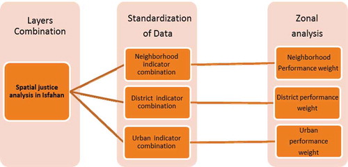
Regarding the study objectives and related conceptual models, the database is designed in four levels: three levels are concerned with the neighbourhood, district and city, and the fourth with urban space. Here, the purpose is to analyse the first three levels separately and analyse the fourth one based on the combined results obtained thereof.
In order to give weight to the indicators, two weights are used in addition to re-evaluating the layers of concern: (1) proportional efficiencies’ weight, revealing the related proportional importance of efficiencies; and (2) the functional/performance weight obtained through the hierarchical importance of essential needs extracted from interviews.
Questionnaire has been used for weighting the criteria proportional weight and performance weight. In a questionnaire, the criteria have been arranged in the form of a table, and the experts were asked to value the significance of the criteria from 0 to 100. Then, the sum of the scores given to each criterion was determined, and in the next step, the relative weight of the criteria was specified. At the end, in the study, the relative weight of the criteria was used by per cent and the performance weight was used by ranking.
This analysis is made through a combination of spatial analysis instruments/devices. In order to apply the scientific results to the interpretation of the results obtained from the spatial statistical tests, the spatial statistics contribute to the available behaviour, patterns and manners regarding the better perception of the geographic phenomena in its diversity. In this study, the nearest neighbourhood average (NNA) and spatial autocorrelation tests are applied.
3.1. Standards of data
This model is adopted to analyse the spatial social justice in megacity of Isfahan. The GIS software is used for the calculation process of the model, based on the following equation:
where Xi is the absolute number of (X variable) and Xj is the absolute number of (Y variable). This is a simple formula. First, using this calculation formula, the results are shown as a map.
Based on this model, the social justice index can be calculated for neighbourhoods, district and the city scale. If the value of this index is less than 0.4, the given level is completely deprived; the range of 0.4–0.6 is deprived and the 0.6–0.8 is semi-enjoying and more than 0.8 is considered enjoying.
3.2. The NNA test
The spatial distributions and the phenomena are illustrated in this analytic pattern, through the NNA test ().
Table 1. Spatial statistics models calculation method.
3.2.1. The spatial correlation
Correlation among the urban analyses is so great that it cannot be observed or discussed in a local sense.
In recent years, the fact that the analysis of spatial data requires specialized techniques different from those adopted in analysing non-spatial data has turned into a major concern (Getis Citation2007). Most standard methods of the statistical analysis applied in the social and environmental sciences are based on the basic assumptions of independence and homogeneity that are rarely met by spatially distributed observations and variables. Spatial dependence refers to the notion that locational proximity often results in value similarity when most demographic or socio-economic variables are mapped, following Tobler’s first law of geography: ‘everything is related to everything else, but near things are more related than distant things’ (Tobler Citation1970). A large body of literature in social science is focused on the development of methods that can be adopted in detecting violations of the independence assumption and spatial econometric techniques that account for spatial dependence or autocorrelation in the given data (Cliff and Ord Citation1981; Anselin Citation1988; Odland Citation1988; Anselin Citation2005). With respect to the studies conducted on quantitative environmental justice, recent studies emphasize on and demonstrate the application of the simultaneous autoregressive models that explicitly consider the effects of spatial dependence (Pastor, Sadd, and Morello-Frosch Citation2004; Grineski and Collins Citation2008; Chakraborty Citation2009).
Autocorrelation is the relationship among the remainder values in regression. This analysis provides useful information regarding the internal effects through which many complex statistical analyses can be run (see ).
In this table, average nearest neighbourhood (ANN) is of concern and is defined and explained as follows: The ANN distance tool measures the distance between each feature centroid and its nearest neighbour’s centroid location. Then, it averages out all these nearest neighbour distances. If the average distance is less than the average of a hypothetical random distribution, the distribution of the features being analysed is considered clustered. If the average distance is greater than a hypothetical random distribution, the features are considered dispersed. The index is expressed as the ratio of the observed distance divided by the expected distance (expected distance is based on a hypothetical random distribution with the same number of features covering the same total area) (http://resources.esri.com/help/9.3/ArcGISDesktop).
3.2.2. Conceptual model
According to the applied indicators and models, for each level of analysis, the database of each level is designed by ARC GIS software upon which the appropriate analysis is run.
For megacity of Isfahan, there are three NNA tests: spatial analysis indicators of justice in the neighbourhood, district and the city levels (see ). It should be noted that the analysis of each level is conducted separately.
Figure 1. The conceptual model of spatial justice for city of Isfahan.
4. Results
4.1. Social justice criteria
This concept, just like the other philosophic and scientific ones, was first dealt with through the intellectual judgement of the early Greek philosophers. According to the philosophies Plato and Aristotle, every social stratum must enjoy the social advantages. To the contemporary philosophers, all human being enjoy the services of natural and instinct rights like living, freedom, life style and so on, even before entering the society. The functionalisms believe that the social imbalance is justified and normal provided that the even opportunities, merits and obligations prevail. This permissible imbalance indicates the difference in individuals’ merits (Marshall and Swift Citation1993). The school of structural geography emphasizes on the resource allocation with respect to actualization of social justice. Harvey (Citation1973) introduced many criteria; the most important ones of which are the need, benefit and worthiness. He found a positive significant relationship between the expansion of imbalance and the neoliberal capitalistic order.
In this study, the human basic needs constitute the basis for fulfilling urban services. Quantitative metrics have already been reviewed in other articles and researches. Therefore, they have the appropriate reliability to explore the city of Isfahan. In establishing justice, the following three criteria are emphasized:
Equality
Need
Merit
The applied indicators here were from different related proportional values with respect to the need type. Consequently, in order to obtain the proper weight and proportional value for each need, questionnaires were distributed and direct interviews were conducted with 20 experts consisting of academic faculty members from different universities and municipality executive authorities of the city of Isfahan in urban affairs (). It should be noted that many quantities to be applied in weighted the spatial analysis were metric, while, as mentioned above, they were selected according to the need type.
4.2. Ranking the indicators based on operational scale
The allocation of urban levels is based on the peoples’ needs and accessibility in different time periods that would add to their importance. According to the indicators of justice, they are provided based on the importance of the operational level at each scale in relation to the other scales with respect to the classified weight (), i.e. if the neighbourhood indicators meet the daily needs, the district indicators meet the weekly needs and the city indicators would meet the monthly needs.
Table 2. Performance level, proportional weight and proportional performance of the justice indicators in Isfahan based on the questionnaires.
4.3. The city of Isfahan
This historical megacity is located in the centre of Iran, it is ranked as the third most populated city (1908,968, in 2014) including 14 districts (see ).
4.4. Analysis of spatial justice in Isfahan
The indicators in this respect are of 21 main groups at 3 operational levels. The human needs are daily, weekly and monthly. They met in these time packages. Therefore, the issue is discussed through a combination of layers and weighting the indicators.
The urban space is formed as a consequent of these three levels’ functionality; therefore, a combination of these three levels in spatial justice in Isfahan is revealed. The outcome of this analysis is standardized and tabulated through ZONAL analysis in tables, figures, diagrams and drawings. The results obtained here indicate 5.28% of enjoyment, 39.59% of semi-enjoyment, 36.19% of deprivation and 18.24% of fully deprivation, i.e. the last two levels constitute 55% of deprivation and fully deprivation. Accordingly, the spatial justice tabulated in Figure 1 is not observed in the city of Isfahan.
4.5. Spatial statistical analysis
The results obtained from the ZONAL analysis are in district level, which indicate the heterogeneous nature of the justice level in Isfahan’s urban space. In this study, autocorrelation tests were applied in order to present a more accurate scientific and spatial analysis.
4.6. The ANN
The content of and is applied to run the ANN test. If the outcome of this test is less than 1, cluster-patterns and injustice are significant, and if it is more than 1, just distribution is evident. The numerical results observed here are 111.259 when the determined calculated volume is 155.43. The measured ANN relation is 0.767247; accordingly, a cluster-patterns injustice in spatial distribution indicates the priority of some districts over the others. The calculated standard ranking is 19.17754 with respect to the value of zero. The obtained results indicate that there exists a statistical significance in these clusters (see and ).
Table 3. The analysis of spatial justice in Isfahan.
Figure 2. Map of Isfahan districts.
Source: Isfahan municipality.
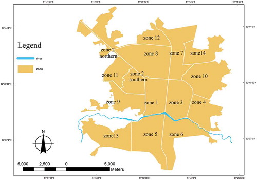
Figure 3. The bar-chart diagram for the spatial justice in Isfahan.
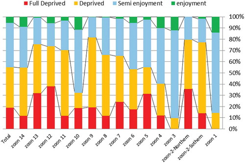
Figure 4. Distribution of spatial justice in the city of Isfahan.
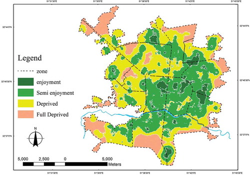
Figure 5. The cluster-patterns diagrams and indicators of spatial justice.
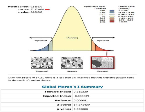
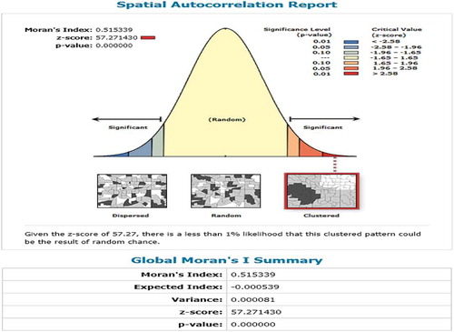
4.7. The spatial autocorrelation test
The content of is applied to run the ANN test. One of the tests made in this field is the Moran test. This test indicates that if there is any spatial justice, it has a scattered cluster distribution. The Moran indicator test in this study is 0.515339. A positive number approaching 1 indicating the existence of spatial autocorrelation in cluster form. If these indicators were distributed in a normal and just manner, the Moran indicator would have become −0.000539. With respect to the indicator by 57.27143, and the P-value of 0 with a big gap among them, the autocorrelation on the cluster-patterns of the data or the spatial justice indicators in the city of Isfahan can be verified as statistically significant (see ).
Figure 6. The spatial autocorrelation diagram and indicators of spatial justice.
5. Conclusion
Justice, the greatest wish of the social structures, is the most attractive concept for human and is the core of discussion among the thinkers since a long time ago. No school of thought or political philosophy has been able to ignore this concept, but some have given their own definition fitting to their societies in the ideal form. In this study, the manner of comprehending justice was studied to obtain considerable and rational results in order to expand the urban spatial justice with respect to the fair opportunity, need and merit criteria as the bases. To this end, the indicators were selected according to the essential or vital needs. The findings indicated 5.28% of enjoyment, 39.59% of semi-enjoyment, 36.19% of deprivation and 18.24% of fully deprivation, i.e. the last two levels constitute 55% of deprivation and fully deprivation proving the existence of dualism and spatial imbalance in the city of Isfahan. In order to implement the results of this study, both ANN and spatial autocorrelation tests were conducted. The results obtained from both tests indicated that the spatial justice in the city of Isfahan was heterogonous and of cluster type. There was a statistical significance at the test levels revealing a weakness in the structural order of this city due to decentralized management. This significance indicates the clustered and cliché-ship focus of the urban management and planning of Isfahan and weakness in the structure and system of these two as well as the policies and ideology that have not been able to take step towards the human excellence.
A comparative study of the status of taking the advantage of the spatial justice in Isfahan suggests that they should be considered in future’s policy implications and planning:
In the vehicular and peripheral textures of Isfahan city, the justice status is in a lower level than the organic and planned textures.
In worn-out and historically textures, the spatial justice is in a more suitable status that the other inefficient urban texture types such as rural centres in the city’s body.
Investigation of the relationship between spatial justice and the historical procedure of the urban development and formation shows that the spatial justice in city centres is in a better position than the other recently developed urban spaces.
Investigation of the relationship between the population density and spatial distribution of justice indices shows that in the areas with average urban density, the spatial justice is in a better condition.
Studying the relationship between the spatial justice and the social classes of the city indicates that in poorer and migratory neighbourhoods, the spatial justice is in an inappropriate condition.
Disclosure statement
No potential conflict of interest was reported by the authors.
References
- Albo, G. 2009. Challenges for Urban Social Justice Movements: Neoliberal Urbanism, the Canadian City and Toronto. Toronto, ON: Centre for Social Justice.
- Andreas Philippopoulos-Mihalopoulos. 2010. International Journal of Law in Context 6 (3): 201–216. Cambridge University Press. doi:10.1017/S174455231000011X.
- Anselin, L. 1988. Spatial Econometrics: Methods and Models. Dordrecht, The Netherlands: Kluwer Academic.
- Anselin, L. 2005. Exploring Spatial Data with GeoDa: A Workbook. Urbana, IL: Center for Spatially Integrated Social Science. http://www.csiss.org/51(61801).
- Balaceanu, C., D. Apostol, and D. Penu. 2012. “Sustainability and Social Justice.” Social and Behavioral Sciences 62: 677–681.
- Blomley, N., D. Delaney, and R. Ford, eds. 2001. The Legal Geographies Reader. Oxford, UK: Blackwell, Brighenti.
- Boer, J. T., M. Pastor Jr., J. L. Sadd, and L. D. Synder. 1997. “Is There Environmental Racism? The Demographics of Hazardous Waste in Los Angeles County.” Quarterly of Social Science 78 (4): 793–810.
- Bowen, W. 2002. Environmental Justice through Research-Based Decision Making. New York, NY: Routledge.
- Bowen, W. M., M. J. Salling, K. E. Haynes, and E. J. Cyran. 1995. “Towards Environmental Justice: Spatial Equity in Ohio and Cleveland.” Annals of the Association of American Geographers 85 (4): 641–663.
- Burke, L. M. 1993. “Race and Environmental Equity: A Geographic Analysis in Los Angeles.” Geo Info Systems 3 (9): 44–50.
- Buzzelli, M. 2008. Environmental Justice in Canada – It Matters Where You Live. Ottawa, ON: Canadian Policy Research Networks.
- Chakraborty, J. 2009. “Automobiles, Air Toxics, and Adverse Health Risks: Environmental Inequities in Tampa Bay, Florida.” Annals of the Association of American Geographers 99: 647–697.
- Chakraborty, J., L. A. Schweitzer, and D. J. Forkenbrock. 1999. “Using GIS to Assess the Environmental Justice Consequences of Transportation System Changes.” Transactions in GIS 3 (3): 239–258.
- Chakraborty, J., and M. P. Armstrong. 1997. “Exploring the Use of Buffer Analysis for the Identification of Impacted Areas in Environmental Equity Assessment.” Cartography and Geographic Information Systems 24 (3): 145–157.
- Cliff, A. D., and J. K. Ord. 1981. Spatial Processes: Models and Applications. London: Pion Limited.
- Dikec, M. 2001. “Justice and the Spatial Imagination.” Environment and Planning A 33: 1785–1805.
- Dinga, E. 2014. “Social Capital and Social Justice, 1st International Conference ‘Economic Scientific Research - Theoretical, Empirical and Practical Approaches’ (ESPERA) (2013).” Economics and Finance 8: 246–253.
- Dufaux, F. 2008. “Birth Announcement, Justice Spatial/Spatial justice.” www.jssj.org
- Furman, G. C., and C. M. Shields. 2003. “How Can Educational Leaders Promote and Support Social Justice and Democratic Community in Schools.” In A New Agenda for Research in Educational Leadership, 119–137. New York, NY: Teachers College Press.
- Getis, A. 2007. “Reflections on Spatial Autocorrelation.” Regional Science and Urban Economics 23: 491–497.
- Grineski, S., and T. Collins. 2008. “Exploring Environmental Injustice in the Global South: Maquiladoras in Ciudad Jua´Rez.” Population and Environment 29: 247–270.
- Harvey, D. 1973. Social Justice and the City. Athens: University of Georgia Press. http://resources.esri.com/help/9.3/ArcGISDesktop/com/Gp_ToolRef/spatial_statistics_tools/how_average_nearest_neighbor_distance_spatial_statistics_works.htm.
- Kinman, E. 1999. “Evaluating Health Service Equity at a Primary Care Clinic in Chilimarca, Bolivia.” Social Science and Medicine 49 (5): 663–667.
- Ko-Wan, T., H. Yu-Ting, and Y.-L. Chang. 2005. “An Accessibility-Based Integrated Measure of Relative Spatial Equity in Urban Public Facilities.” Cities 22 (6): 424–435.
- Kunzmann, K. R. 1998. “Planning for Spatial Equity in Europe.” International Planning Studies 3 (1): 101–121.
- Lefebvre, H. 1972. Le Droit à la Ville de Henri Lefebvre à David Harvey, Entre Théorisations et Realization. L'Homme et la Société.
- Lehman-Frisch, S. 2011. “Segregation, Spatial (In) Justice, and the City.” Berkeley Planning Journal 24 (1): 69–90.
- Maantay, J. A. 2002. “Mapping Environmental Injustices: Pitfalls and Potential of Geographic Information Systems (GIS) in Assessing Environmental Health and Equity.” Environmental Health Perspectives 110 (Suppl. 2): 161–171.
- Marshall, G., and A. Swift. 1993. “Social Class and Social Justice.” Gordon the British Journal of Sociology 44 (2): 187–211.
- Martínez-Martin, J. A. 2005. “Monitoring intra-urban inequalities with GIS-based indicators: with a case study in Rosario, Argentina.” Doctoral dissertation, Utrecht University.
- Miller, D. 1999. Principles of Social Justice. Cambridge, MA: Harvard University Press.
- Mitchell, A. 1999. The ESRI Guide to GIS Analysis: Geographic Patterns & Relationships (Vol. 1). Redlands, CA: ESRI, Inc.
- Morello-Frosch, R., M. Pastor, and J. Sadd. 2001. “Environmental Justice and Southern California’s “Risk-Scape”—The Distribution of Air Toxics Exposures and Health Risks among Diverse Communities.” Urban Affairs Review 36 (4): 551–578.
- Neumann, C. M., D. L. Forman, and J. E. Rothlein. 1998. “Hazard Screening of Chemical Releases and Environmental Equity Analysis of Populations Proximate to Toxic Release Inventory Facilities in Oregon.” Environmental Health Perspectives 106 (4): 217–226.
- Odland, J. 1988. Spatial Autocorrelation. Newbury Park, CA: Sage.
- Pastor, M., J. L. Sadd, and R. Morello-Frosch. 2004. “Waiting to Inhale: The Demographics of Air Toxic Release Facilities in 21st Century, California.” Quarterly of Social Science 85: 420–440.
- Pearsal, H., and J. Pierceb. 2010. “Urban Sustainability and Environmental Justice: Evaluating the Linkages in Public Planning/Policy Discourse.” Local Environment 15 (6): 569–580.
- Perlin, S. A., R. W. Setzer, J. Creason, and K. Sexton. 1995. “Distribution of Industrial Air Emissions by Income and Race in the United States: An Approach Using the Toxic Release Inventory.” Environmental Science Technology 29 (1): 69–80.
- Pollock, P. H., and M. E. Vittas. 1995. “Who Bears the Burden of Environmental Pollution? Race, Ethnicity, and Environmental Equity in Florida.” Quarterly of Social Science 76 (2): 294–309.
- Prilleltensky, I., and L. Gonick. 1996. “Polities Change, Oppression Remains: On the Psychology and Politics of Oppression.” Journal of Political Psychology 17: 127–148.
- Raleigh, C., and H. Hegre. 2009. “Population Size, Concentration, and Civil War. A Geographically Disaggregated Analysis.” Political Geography 28 (4): 224–238. doi:10.1016/j.polgeo.2009.05.007.
- Rebore, R. W. 2001. The Ethics of Educational Leadership. New Jersey: Prentice-Hall.
- Sheppard, E., H. Leitner, R. B. McMaster, and T. Hongguo. 1999. “GIS-Based Measures of Environmental Equity: Exploring Their Sensitivity and Significance.” Journal of Exposure Analysis and Environmental Epidemiology 9: 18–28.
- Soja, E. 2000. Post Metropolis: Critical Studies of Cities and Regions. Oxford: Basil Blackwell.
- Soja, E. 2008. “The City and Spatial Justice, Justice Spatial/Spatial Justice.” In International Conference “SPATIAL JUSTICE”, edited by Habitat International Coalition, March 12–14. Nanterre: University of Paris X. www.jssj.org
- Speight, S. L., and E. M. Vera. 2004. “A Social Justice Agenda: Ready, or Not?” The Counseling Psychologist 32 (1): 109–118.
- Spohn, W. C. 2001. “The University that Does Justice.” Conversations on Jesuit Higher Education 19: 4–12.
- Strike, K. A. 1999. “Can Schools Be Communities: The Tension between Shared Values and Inclusion.” Quarterly of Educational Administration 35 (1): 46–70.
- Sui, D. Z., and P. J. Hugill. 2002. “A GIS-based Spatial Analysis on Neighborhood Effects and Voter Turnout: A Case Study in College Station, Texas.” Political Geography 21 (2): 159–173.
- Swyngedouw, E., and N. Heynen. 2003. “Urban Political Ecology, Justice and the Politics of Scale.” Journal: Antipode 35 (5): 898–918. doi:10.1111/j.1467-8330.2003.00364.x.
- Tarrant, M. A., and H. K. Cordell. 1999. “Environmental Justice and the Spatial Distribution of Outdoor Recreation Sites: An Application of Geographic Information Systems.” Journal of Leisure Research 31 (1): 18–34.
- Tobler, W. R. 1970. “A Computer Movie Simulating Urban Growth in the Detroit Region.” Economic Geography 46: 234–240.