
ABSTRACT
Due to the increasing complexity of GIS data and service modes, there is an urgent need for the next generation of GIS with new representation and computation methods. A number of spatiotemporal models, analytical and visualization methods, as well as system architectures have been proposed. However, previous studies failed to integrate basic geographical theories with latest computing technologies. Without a well-defined body of underlying theories, new models and methods are limited in scope and not able to meet the ultimate requirements of the next-generation GIS, which demands multidimensional, highly dynamic and semantic-rich representations and computational power. Geometric algebra (GA) provides an ideal tool for the expression and calculation of multidimensional geometric objects, and has proved to be effective for GIS representation and computation applications in our previous studies. We propose to use GA as the basic mathematical language for the establishment of the next-generation GIS. We present the framework of a GA-based next-generation GIS and describe the representation space, data structure, and computational models in this paper. A few issues that have not been sufficiently addressed by previous studies are discussed in detail with potential solutions proposed. These include multi-scale representations, modelling of geographic processes, simulation of geographic interactions, and multi-element modelling. The GA-based next-generation GIS uses an integrated structure consisting of a theoretical architecture, model for information expression, and computational methods. Implementation of the approach aims to improve GIS capacities in applications such as global spatiotemporal modelling and analysis, regional geographic modelling and simulation, smart city applications, and many others.
1. Introduction
The first Geographic Information System (GIS) was developed half a century ago in Canada by Roger Tomlinson (Tomlinson, Calkins, and Marble Citation1976). After two decades of development in software engineering and with response to GIS market need, four types of GIS architectural configurations emerged, including desktop, client-server, centralized desktop, and centralized server (Longley, Goodchild, and Maguire et al. Citation2015). The focus during this era was to make the implementation of GIS projects more efficiently with centralization and standardization. The twenty-first century came with great advances in communication technologies and mobile devices. This gave birth to distributed GIS, with the main architecture changed to a Browser-Server, Cloud GIS or IoT GIS type (Alesheikh, Helali, and Behroz Citation2002; Bhat, Shah, and Ahmad Citation2011; Cao and Wachowicz Citation2019). From a hardware perspective, GIS technology seems to have advanced considerably. However, the underlying theories and models are falling behind, calling for further development (Goodchild Citation2011).
This is even more the case as we enter the big data era. GIS now needs to deal with more complex data such as high dimensional data, streaming data, and unstructured data pertaining to volunteered geographic information. At the same time, GIS software and service are being used by much diverse users in more complicated scenarios, creating an urgent need for an intelligent and flexible next-generation GIS. Next-generation GIS refers to new representation models that can handle the multidimensional features, spatiotemporal features, and semantic-rich features of data, and analytical methods that can process different types of data and support the use of GIS software in a convenient and prompt way. To address these needs, the development of new GIS representation, computation, and service models have drawn considerable attention during the past decades.
With regard to representation models, unified data models such as the vector/field model (Winter and Frank Citation2000; Kjenstad Citation2006), the object field model (Cova and Goodchild Citation2002), the geo-ontology model (Galton Citation2003) and the geo-atoms-based model (Goodchild Citation2007) were developed for the simplification and integration of previous geographic data models. However, due to the lack of a well defined and established body of underlying theory (Goodchild Citation2011), these models are limited to conceptual formalizations and are difficult to implement. Alternatively, some other approaches make use of object-oriented programming to realize unified representations and computations through parametric polymorphism (Manola and Dayal Citation1986; Huang Citation2003). However, object abstraction, as well as updating and extending the predefined objects, can be challenging. Therefore, applications of these approaches have been limited to the specific areas in which they were developed.
With regard to computation methods, much research has focused on the parallelization of GIS operations (Healey et al. Citation1997). Efforts have been in three main areas including the design of advanced architecture, data parallelization and parallelization of spatial analysis algorithms (Zhao et al. Citation2016). Examples of advanced architecture include Grid GIS (Shen et al. Citation2004; Wang Citation2010), Cloud GIS (Bhat, Shah, and Ahmad Citation2011; Yang et al. Citation2011), Hadoop GIS (Aji et al. Citation2013) and Spark GIS (Yu, Wu, and Sarwat Citation2015). Data parallelization is usually based on well-defined data partition strategies (Zhang et al. Citation2016; Zhao, Padmanabhan, and Wang Citation2013; Lee and Hamdi Citation1995; Sloan et al. Citation1999). However, due to the unstructured nature and characteristics of spatial data concerned with spatial relationships, there are very few universal spatial data partition strategies, especially for vector data (Zhao et al. Citation2016). Algorithm parallelization methods focus on the parallelization of serial algorithms (Healey et al. Citation1997). Most of these methods are based on data decomposition and thus face the same challenge as data parallelization. Those methods based on algorithm decomposition are often algorithm-specific, thus making broader applications not possible (Zhao et al. Citation2016).
With regard to the service model, the development of a user-friendly and comprehensible tool set as well as an operation library is critical. However, it is still a big challenge for even dominating commercial software (Gao and Goodchild Citation2013). As early as 1988, Rhind and Albrecht had attempted to create a universal GIS operation library by analysing the underlying spatial principles (Rhind and Green Citation1988; Albrecht Citation1995). At that time, without a unified data representation, these universal GIS operations only focused on the taxonomies of GIS functions. The concept of service-oriented GIS was also raised based on the idea of hiding the complexity of GIS operations at the server side while providing easy-to-use functions to the users via their browsers. However, this could not be fully implemented due to the complex scheduling model of service-oriented GIS and unresolved data security and privacy issues. Some other GIS systems focused on the human–GIS interaction (Gao and Goodchild Citation2013) from the human spatial cognition perspective. However, spatial cognition is a deeply theoretical area of study and such an approach has only been used in simple queries and retrieval operations.
In summary, past research on next-generation GIS generally falls into two categories. The first is to reconstruct the representation and computation models based on abstract theories of geographical representation and spatial cognition; and the second aims to improve the representation, computation, and architecture of existing GIS using emerging computer techniques. It is noted that existing representation and computation methods of GIS draw from the different fields of geometry, cartography and computer graphics. Specifically, the reference framework of space representation takes a cartographic perspective; computations are based on Euclidean and computational geometry; and spatial data management and analysis borrow techniques from computer science. This mixed framework has limitations as there is often inconsistency in the expression of geographical semantics, representation of multi-scale spatiotemporal evolution processes, and modelling of geographical object interactions. Therefore, it is necessary to innovate GIS from the very foundation, that is, the underlying theory. It should be independent of the ever-changing computer technology and can support an uniform representation and computation of complex geographical objects and phenomena.
Geometric algebra (GA) provides an ideal tool for the representation and computation of multidimensional geometric objects (Dorst, Fontijne, and Mann Citation2009; Hitzer et al. Citation2013). Our previous work (Yuan et al. Citation2011) addressed the uniform representation of GIS primitives with different dimensions and types. GA multivectors were used as the basic data structure to unify all representations of geographic data (Yuan et al. Citation2011). On the basis of such representations, typical GIS operations such as the computation of topological relationships (Yuan et al. Citation2014a; Yu et al. Citation2016), the analysis of field characteristics (Yu et al. Citation2013), and network analysis (Yuan et al. Citation2013a) were implemented to demonstrate the feasibility of the new GA framework.
In this paper, we present the approach to the next-generation GIS based on GA. Major findings from our previous research are summarized, on the basis of which key issues for the next step and possible breakthroughs are identified. This paper is organized as follows: the basic idea of the next-generation GIS based on GA is described in detail in Section 2. Future work and research directions are proposed in Section 3. and Section 4 presents concluding remarks.
2. GA-based GIS
2.1. Basic idea
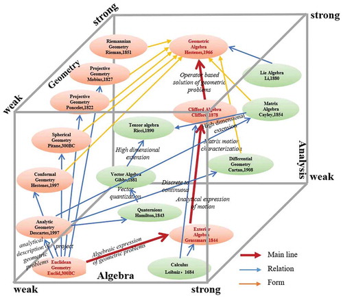
Non-Euclidean geometry expands the mathematical and physical space from absolute to relative parameters. This lays the mathematical foundation for the change from Newton’s absolute space view (Euclidean space) to Einstein’s relativistic space view (Minkowski space and Riemannian space). GA is as an important breakthrough in the development of non-Euclidean geometry, which is a unified description language used to link geometry and algebra, mathematics and physics, and ultimately achieve the unified expression of Euclidean, Minkowski and Riemann spaces. GA, as the name implies, is characterized by representing, constructing and manipulating geometric objects with an algebraic language. Various geometric systems (such as projective geometry, affine geometry, conformal geometry, differential geometry, etc.) and algebraic systems (such as calculus, tensor algebra, Boolean algebra, space-time algebra, etc.) can be mapped to GA spaces (). Therefore, GA can be used to build an unified framework of geography and space-time, for innovatively constructing unified multidimensional representations, and develop analysis and modelling methods in GIS. It is also compatible with the data models, computational and analytical methods of a more general GIS based on mathematical theory.
Figure 1. The GA family tree.
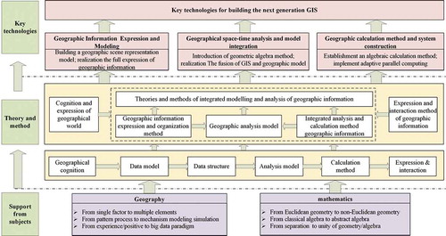
Based on GA, an integrated framework for modelling and analysis was proposed (Yuan et al. Citation2010) as illustrated in . At the core of the framework is the geo-scene-based data model, which deals with the representation of multi-dimensional fusion of time and space, the general geographic content, as well as a multi-scale evolution process. The GIS data model is constructed based on spatial cognition, on top of which corresponding computational methods are developed. As the GA space is easily customizable, geospatial cognition, representation and interactions can all be built into the data model. This results in integration of the geometric structure, motion process and semantic constraints of geo-objects. In the GA space, geographic problem solving is operator-based using algebraic methods. The three key components of the framework are: GA-based spatiotemporal representation, GA-based date structure for GIS modelling, and GA-based analytical methods. These three components constitute the complete technical process of a next-generation GIS.
Figure 2. The framework of establishing the next-generation GIS.
2.2. Conceptual model of GA-based geographical spatiotemporal representation
GA is at the core of the conceptual model for representing geographical space-time, which is the foundation for integrated modelling and analysis of complex geographical objects and phenomena. The representation model possesses three important qualities to be able to represent a broad array of different types of geographic information: 1) integrated geometric expression and algebraic operations; 2) unified representation of discrete objects and continuous processes; 3) integrated representation of geometric structures and spatial relationships.
Conventional representation methods were designed based on Euclidean geometry and computational geometry. As a result, space-time representation and multi-dimensional expressions of geometric objects may not be consistent. Moreover, geographic calculation is not well supported because of the lack of algebraic structure. GA addresses these issues through unification of different mathematical spaces: the Euclidean, homogeneous and conformal spaces. Mappings between different coordinate systems (Euclidean/projection/spherical) and three types of GA spaces are illustrated in ). The geometric representation and computation model consists of a GA structure (blade, multivector, etc.) and GA operations (outer product, inner product, etc.). A unified representation of multidimensional vector geographic objects is developed based on Grassmann structure and multivector structures. GA operators will adapt to the dimensions of objects, when creating a unified representation of geometry and metric computation. With this model, dimensions and measurements are correlated and the geometry, topological relations and geometric metrics can be represented altogether with a multivector structure. This provides the basis for algebraic and functional representation of complex geographic scenes (Yuan et al. Citation2012).
Figure 3. The geographical space-time construction and expression theory based on GA.
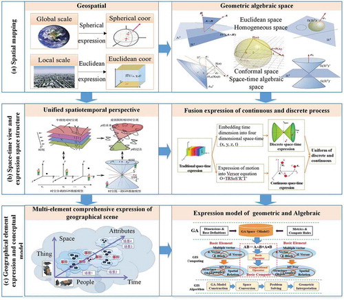
A unified spatiotemporal GIS representation based on GA addresses the limitation of conventional space-time process representations, which is incapable of handling high-speed dynamic phenomena and often separate time and space. As illustrated in ), the unified spatiotemporal representation is composed of hyperbolic complex and space-time algebraic spaces. The GA Versor equation is the key component. It consists of the three basic Euclidean transformations (translation, rotation and scaling), and can be used to realize parameterized representation and interpolation of rigid body motions. A unified representation of both discrete and continuous geographic objects (Yuan et al. Citation2012) is supported. The Lorenz transformation is introduced to realize the representation of space-time fields from various viewing angles but restricted to constant metrics. In addition, a hierarchical and adaptive spatial index is included to optimize the representation of cube-style spatiotemporal data. These specific designs lay the foundation for the unified representation of continuous/discrete objects and integrated geometric/algebraic calculation for general geographical space-time process representation and computation (Yuan et al. Citation2010).
Next, a new GIS modelling and analysis approach with unified data representation, data management, and computational structures is developed based on the concept of geographic scenes and GA multivectors (). The six-element (semantics, locations, shapes, attributes, relationships and evolutionary processes) conceptual model aims to handle complex geographic objects and phenomena. In addition, an algebraic representation model is constructed based on the dynamic evolution process representation of Versor and a data description method is developed based on a multi-layer, multi-temporal space-time of event-state mechanism. Finally, the approach to modelling complex geographic data is developed based on multi-layer, multi-dimensional and multi-attribute structures (Yuan et al. Citation2011). This provides the mathematical and theoretical basis for integrated information modelling of geographic multi-factors (Hu, Luo, and Yu et al. Citation2015).
The above conceptual model shows a new direction for the application of Non-Euclidean geometry represented by GA in geographic information science. It lays the theoretical foundation for geographic information modelling and analysis under the unified framework of time and space. Suitable for spatiotemporal representation of geographical objects and dynamic geography processes, it provides a new way for fusing geographical objects, motion processes, temporal and spatial relationships in geographical scene modelling and analysis.
2.3. GA-based data structure for GIS modelling and computation methods
Conventional GIS modelling and computation methods face three main challenges: the separation of GIS object representation and calculation, non-uniformity of multidimensional operations, and separation of the time and space dimensions. To solve these problems and provide technical support for multidimensional space-time analysis, the next-generation GIS needs to provide: 1) effective multidimensional data models and data structures and 2) adaptive computing methods for different GIS spatial analysis.
With large amount of geospatial data evolving from 2D to 3D, an effective data structure becomes the key issue affecting the performance of modelling and computing. Furthermore, most GIS data are highly unstructured and nonlinear (Frank Citation1992), which demands a well-defined algebraic system for structuring the data representation. A solution is the unification of topology and metrics structure, with which the geometric and algebraic aspects of geographic representation are fused. A hierarchical structure is also necessary for representing complex geographic objects based on multivectors. Building on top of the characteristics of typical data models such as vectors, networks and space-time fields, a GA-based general spatial data structure is first formulated ()). Next, three specific data models are constructed, which include 1) a multidimensional vector data model that integrates dimensional structures, geometric metrics, and topologies; 2) a spatiotemporal data model based on a hierarchical tensor structure; and 3) a multi-constraint GA network data model that combines network objects, topologies and constraints. These three specific data models are consistent, built with the same mathematical language of GA. Combined together, they make up the multidimensional GIS scene data model that unifies the data representation, management, and computational structures (Yuan et al. Citation2013a, Citation2014a, Citation2014b).
Figure 4. The GIS modelling and computing framework based on GA.
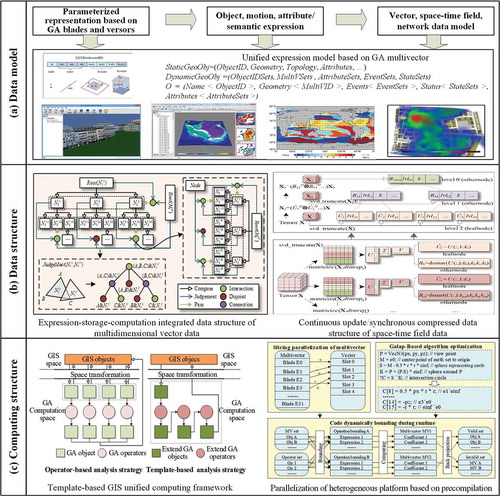
) illustrates a multivector tree (MVTree) data structure. It is designed for structured hierarchical organization of complex geographic scenarios, maintaining structural consistency of expression, organization and computation (Yuan et al. Citation2014b; Yu et al. Citation2015; Luo et al. Citation2017b). The structure incorporates space-time field data and network data. Specifically, a hierarchy tensor-based space-time field data structure represents high-dimensional space-time fields. A multi-constrained spatiotemporal network structure stores object-topology-constrained geographic network data. With these well-defined hierarchical structures, it is convenient to perform real-time retrieval and calculation of complex 3D solid objects, while maintaining compressed storage of high-dimensional space-time field sequences and unified path extending-constraint embedding-optimal path searching of dynamic network paths (Yuan et al. Citation2014a, Citation2014b; Zhu et al. Citation2018).
Next, the conceptual framework for multidimensional GIS computation is constructed based on GA adaptive operator calculations ()). The framework is composed of a set of GA-based GIS computational operators and the formalization of GIS objects. This is realized through the integration of geographic geometry model and algebraic analysis. With such integration, the complex construction, description and integration of GIS algorithms is simplified to formalized GIS analysis and its template-based implementations (Luo et al. Citation2017a). Adapted to formalized GA expressions, the calculations of metrics, geometry, and topological relationships are performed with Boolean logic-style GA products (i.e. outer product, inner product, geometric product; Dorst, Fontijne, and Mann Citation2009). The binary coding and pre-defined table (Hildenbrand Citation2013) of these products are also incorporated to realize the pre-compilation and automatic optimization (or parallelization) of GA-based algorithms for different systems/platforms and parallel environments (like CUDA and GPC; Hildenbrand Citation2013). To demonstrate these methods, several optimized algorithms such as triangulation intersection, change detection and DEM aspect extraction were developed (Yu et al. Citation2015). The proposed heterogeneous parallel computing system based on operators and GA templates was demonstrated to show consistency and adaptability of the computational structure. This provides the theoretical basis for the optimization of spatial computation processes.
This GA-based data model is designed to realize an integrated representation of geographic information and support the modelling and analysis of geographic objects and processes. On one hand, the proposed data structure improves the consistency of GIS representation, organization and computation. On the other, it simplifies the process of developing GIS algorithms for multidimensional unified geo-processing, modelling, and simulation. The proposed computation framework provides a methodological basis for the creation of algorithms for the next-generation GIS which combines geometry and algebra, reprsentation and computation.
2.4. GA-based analyses
Existing GIS has limited support for analysing geographical space-time processes and integrating GIS models. GA-based analysis methods aim to address these limitations and account for the usually multi-dimensional and coupled multi-element geographic processes and scenes. This lays the foundation for parameterized dynamic geospatial computations, and the integration of the geospatial computations with geographic processes.
GIS topological relationships have been calculated traditionally through algebraic abstractions to achieve topology invariance. It often relies on complicated calculation with little flexibility. With the proposed approach, representation and calculation of the spatial objects’ topological relationships are achieved through algebraization and formalization of geometric meanings (). Abstract topological relationships are interpreted with functional mapping patterns to reduce possible conflicts caused by pure abstract topology calculations. The computation model of the topological relations and metric relations of geometric objects are integrated based on multivector representation. In addition, the computation model for dynamic object spatial relationships is also incorporated into geographic scenes, which lays the theoretical foundation for parallel computing of formal, structured and dynamic spatial relationships among geographic objects in complex scenes (Yuan et al. Citation2014b; Yu et al. Citation2015).
Figure 5. The space-time unified analysis method based on GA.
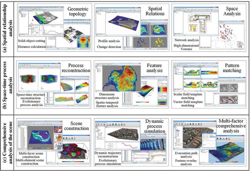
With traditional methods, it has been difficult to support the computation and characterization of vector and scalar fields simultaneously. The proposed approach uses a unified representation and computation model to calculate spatiotemporal field structural parameters (i.e. gradient, curl, divergence) with geometric differential and geometric products (). The SVD (Singular Value Decomposition) of the motion process are represented as scalar, vector and multivector fields, and an optimal matching algorithm calculates the feature parameters of geo-spatiotemporal processes. In addition, a space-time field template convolution and similarity calculation module based on Clifford-Fourier Transform is included. A structure-driven space-time field filtering method is designed for data segmentation and clustering. And a template matching method based on geometric differentials is available for handling the divergence and convergence characteristics of spatiotemporal field. Therefore, the template convolution time-space feature analysis can simultaneously support scalar and vector field analysis, while realizing the geographic process similarity measurement and feature extraction by taking into account the evolutionary strength and direction of evolution. This approach provides both a theoretical and methodological basis for parametric representation, feature analysis and process simulation of continuously changing geographical phenomena and processes (Yuan et al. Citation2013b; Yu et al. Citation2013).
In addition to achieving integrated modelling and coupled analysis of multiple geographic data points, the GA-based approach accounts for 3D geometric entities, multidimensional topological networks, object-oriented spatiotemporal trajectories and metric relationships ()). Multidimensional geographic analysis method is developed based on the geographic scenes theory (Yuan et al. Citation2014b; Lv, Chen, and Yuan et al. Citation2018). Objects in a scene are dynamically updated based on multivectors with simultaneous update of heterogeneous data in the geographic scenario. The proposed method was implemented in a study to describe characteristics of the Antarctic ‘Ice–Ocean–Land’ data and simulate the evolution process (citation needed here). This application is an example of integrated modelling and feature analysis of multi-layer, multi-element and multi-temporal geo-evolution processes. It illustrates the use of the proposed approach for unified representation and dynamic analysis on formal, integrated complex geographic data and scenarios.
With the proposed framework, topological computations and spatiotemporal analysis reach multidimensional uniformity and are independent of coordinate systems. This consistent, multidimensional and unified framework serves as the methodological basis for parametric representation, feature analysis and process simulation of geographic phenomena and processes. GA-based analysis of geographic scenes and the implemented integrated modelling provide support for the development of analytical GIS based on geographic scenarios.
3. Future work
3.1. Multi-scale unified representation of geographical space-time patterns
Existing methods for representing geographical space and time patterns face challenges such as imprecise measurement and lack of formal descriptions. The flexibility of GA expanding to high dimensions enables it to serve as the abstract model of geography space-time. A scale dimension can be introduced to construct the formalized and computable space-time that is multivariate and multi-scale. From a research perspective, the underlying mechanism of GA representation of multi-scale geographic objects and geographic spatiotemporal patterns in the space-time reference system should be studied further. From a practical geographic analysis perspective, a multi-dimensional and multi-scale data model with the ability to combine data from multiple information sources and ability to integrate continuous and discrete data should be developed to model spatial and temporal distributions.
Two critical issues lie in this direction of future research. First, a spatiotemporal data model that can account for both characterization of the time-space and pattern simulation in the time-space needs to be established. Homogeneous measured relationships based on different GA spaces have been studied to represent multiscale space-time objects based on the scaling function. A spatiotemporal data model constructed this way is able to describe the characteristics of space-time patterns in a parameterized fashion in multiple spatiotemporal reference systems. Second, there exist large differences in object description, feature structure and analysis requirements in the geographic space at different scales. In order to map them to GA space, the transformation and mapping among these different scales of geographic space and the different kinds of GA spaces need to be further studied. For example, by introducing geometric invariants and isomorphism relations between different GA spaces, a unified spatiotemporal datum can be constructed to describe geographic space at different scales.
3.2. Formalized modelling and GA calculation of geographic processes
Existing representation methods cannot effectively represent complex geographic processes. Formalized modelling and parameterized representation of these processes need to be further developed for coupled representation and modelling based on geographic scenarios. The establishment of GA calculation theory and computational space provides potential to integrate both continuous and discrete processes, and both abrupt and gradual processes. Representation methods can be developed to meet the need of modelling complex, multi-element and multi-phase dynamic geographic processes. Learning from previous research on applications of GA to classical physics, the invariants and associated relations of different spatiotemporal reference systems can be used to establish the functional representation and modelling framework of complex geographic spatiotemporal process based on tensor algebra and GA differentials. Under this framework, the relationship and correlation patterns of different spatiotemporal evolution processes can be identified to construct the GA-based model of geographic processes.
Two critical issues also lie in this direction of future research. First, the Versor expression of continuous and discrete geographic processes need to be constructed with geometric differential and gradient operators. The parameter characterization and extraction of geographic processes must be performed based on geometric differential methods and tensor decomposition methods. In this way, geographic processes can be modelled as a Versor-based expression that intrinsically describes the movement information of the processes. Second, the modelling of the geographic processes need to account for both continuous and discrete geographic processes. The geographic processes must be simulated under the constraints of geographical laws and be able to effectively integrate the constraints of object attributes, semantics and evolution in geographical scenes. How to use the advantage of GA to represent multiple geographic object elements, and how to construct the integrated continuous-discrete geographic processes are the key points to improve the representation and analysis ability of GIS in terms of geographic processes. We propose that the representation of geographical processes can use the expressions of Versor and Spinor on motion and spatial transformation under GA. Adaptive characterization parameters and feature extraction methods of geographical processes will then be constructed.
3.3. Modelling and analysis of geographic interactions
Geographic interaction, as one of the most important elements in a dynamic earth system, is not well represented with current representation models. GA has the advantage of high-dimension extensibility and multivectors are structurally consistent. The coding method of element dimensions in the GA spatiotemporal data model can be extended to construct a GA-based coding mechanism for geo-semantic information. Geographic interactions can then be represented and modelled across and between elements. Finally, an algebraic expression model of multi-factor geographic information can be constructed based on the customizability of GA space, with geographic information element relationships embedded in the GA-based description.
The key issue in this research direction is the dynamic correlation and coupling of geographic elements and interactions, as geographic interactions are dynamic, complex, often relative, and multi-scale. Recognizing the relations and patterns, a GA subspace learning model can be used to represent the interactions of multi-dimensional elements. This makes use of the structural consistency of multivectors and the self-adaptation capability of relationship expressions.
3.4. Coupled multi-element modelling and simulation under geographic scenario constraints
In a classical geographic scenario, coupled multi-element modelling and analysis is common, but difficult to handle using traditional methods. With the combined characteristics of geometry and algebra, GA provides a potential solution for the integrated representation and modelling of geographic constraints. And this can be the fourth research direction. Through mapping between GA and differential equation, statistics, and signal processing methods, typical geographic models can be reconstructed in terms of GA-based models building in the analysis and calculation domain. Based on the algebraic and formal expression of GA and its implicit support for parallel computing, the symbolic, formal construction and parallel computing methods of geographic models can be also established.
There are two aspects in this research direction. The first is further study of the space base, subspace, and space structure of GA in line with geospatial space-time representation models. The second is introducing the description method of GA in areas like signal processing and statistical identification. This leads to ready transformation of existing models into GA-based geographical models.
4. Concluding remarks
In geographical research, we see rapid accumulation of massive and unstructured spatial and spatiotemporal data in recent years. As a result, GIS is faced with an increasing need for multi-scale integrated modelling and real-time dynamic analysis of geographic information. Such modelling and analysis need to be conducted under the constraint of geographical laws. The representation, realization, and integration of geographical scenes take into account the spatial and temporal characteristics, multi-scale properties, and interactions among elements with a geographic scene model. GIS modelling and analysis should follow the same line and ensure comprehensive modelling and coupled analysis of geographical objects and processes from a multi-scale and multi-factor perspective. Modelling should take into account spatial and temporal distribution patterns, evolution process rules, relationships, and interactions.
GA provides unique advantage in terms of geometry expression and unified multidimensional adaptive computing capabilities. This provides an opportunity for comprehensive analysis of geographic phenomena taking into consideration of not only patterns, but the combination of process and interactions. Diverse geographical information can be integrated based on the fusion expression of GA in terms of geographical scenes, leading to development of the theories and methods of a next-generation GIS. Specifically, a GA-based next-generation GIS has (1) the representation power to integrate representation of multiple scales, dimensions, attributes and subspaces, and (2) the analysis capability to describe spatial and spatiotemporal patterns, simulate processes and interactions among geographic objects consistent with basic geographical laws. It is not only a supporting tool and platform for geographic research but a research paradigm. With a systematic 'theoretical architecture – information expression – model analysis – computation' structure, such next-generation GIS expects to improve current GIS capabilities in applications such as global spatiotemporal information modelling and analysis, regional geographic modelling and simulation, and smart city applications, among others.
Our previous work focused on the theoretical and methodological side of GA-based GIS modelling and analysis and broke through the bottlenecks in integrated GIS representation and analysis. There remain three challenges that need further developments. First, more work needs to be done based on GA and geographical scene theory (Lv, Chen, and Yuan et al. Citation2018) by taking into consideration geographical principles and knowledge. The goal is comprehensive modelling and integrated analysis of the six elements of geographic information, including semantics, locations, shapes, and attributes, the relationships among elements and the related evolutionary processes. Second, computation efficiency needs to be further improved through hardware-based optimization. Pure hardware solutions, such as those based on the architecture of the Clifford coprocessor (Franchini et al. Citation2009) and field-programmable gate arrays for GA (Christian, Christian, and Gerald Citation2003) are potential ways to speed up GA computation. Three, the implementation framework of the next-generation GIS needs to be improved. The GA-based system introduced a completely new analysis schema for GIS. The implementation of GA space and GA operators are unfamiliar to current GIS users who are used to the traditional geometric space. Therefore, a self-contained mathematical and algorithmic description of the computational framework could be developed for practical implementations (Eid Citation2018).
Disclosure statement
No potential conflict of interest was reported by the authors.
Additional information
Funding
References
- Aji, A., F. Wang, H. Vo, R. Lee, Q. Liu, X. Zhang, and J. Saltz. 2013. “Hadoop GIS: A High Performance Spatial Data Warehousing System over Mapreduce.” Proceedings VLDB Endow 6 (11): 1009–1020. doi:10.14778/2536222.
- Albrecht, J. 1995. “Universal Analytical GIS Operations — A Task-Oriented Systematization of Data Structure-Independent GIS Functionality.” In: M. Craglia, H. Onsrud, eds.Geographic Information Research: Transatlantic Perspectives, 577–591.London: Taylor & Francis
- Alesheikh, A., H. Helali, and H. Behroz, 2002. “Web GIS: Technologies and Its Applications.” Symposium on geospatial theory, processing and applications, 1-15. Ottawa.
- Bhat, M. A., R. M. Shah, and B. Ahmad. 2011. “Cloud Computing: A Solution to Geographical Information systems(GIS).” International Journal of Computer Science Engineering 3 (2): 594–600.
- Cao, H., and M. Wachowicz. 2019. “The Design of an IoT-GIS Platform for Performing Automated Analytical Tasks.” Computers, Environment and Urban Systems 74: 23–40. doi:10.1016/j.compenvurbsys.2018.11.004.
- Christian, P., G. Christian, and S. Gerald, 2003. “Implementation of a Clifford Algebra Coprocessor Design on a Field Programmable Gate Array.” In: R. Ablamowicz, ed. 6th Conference on Clifford Algebras and their Applications in Mathematical Physics, Tennessee Technological University, Cookeville, 20–25 May 2002. TN: Birkhäuser Boston.
- Cova, T. J., and M. F. Goodchild. 2002. “Extending Geographical Representation to Include Fields of Spatial Objects.” International Journal of Geographical Information Science 16 (6): 509–532. doi:10.1080/13658810210137040.
- Dorst, L., D. Fontijne, and S. Mann. 2009. Geometric Algebra for Computer Science: An Object- Oriented Approach to Geometry. San Francisco: Morgan Kaufmann Publishers.
- Eid, A. H. A. 2018. “An Extended Implementation Framework for Geometric Algebra Operations on Systems of Coordinate Frames of Arbitrary Signature.” Advances in Applied Clifford Algebras 28 (16): 16. doi:10.1007/s00006-018-0827-1.
- Franchini, S. 2009. “An Embedded, FPGA-based Computer Graphics Coprocessor with Native Geometric Algebra Support.” Integration the VLSI Journal 42 (3): 346–355. doi:10.1016/j.vlsi.2008.09.010.
- Frank, A. U. 1992. “Spatial Concepts, Geometric Data Models, and Geometric Data Structures.” Computer Geoscience 18 (4): 409–417. doi:10.1016/0098-3004(92)90070-8.
- Galton, A. 2003. “Desiderata for a Spatio-Temporal Geo-Ontology.” In W. Kuhn, M. F. Worboys, & S. Timpf (Eds.),Spatial Information Theory. Foundations of Geographic Information Science 1–12.Berlin, Heidelberg: Springer Berlin Heidelberg.
- Gao, S., and M. F. Goodchild, 2013. “Asking Spatial Questions to Identify GIS Functionality.” Fourth international conference on computing for geospatial research and application, IEEE. 106–110, San Jose, CA, July 22-24 .
- Goodchild, M. F. 2007. “Citizens as Sensors: The World of Volunteered Geography.” GeoJournal 69 (4): 211–221. doi:10.1007/s10708-007-9111-y.
- Goodchild, M. F. 2011. “Spatial Thinking and the GIS User Interface.” Procedia - Social and Behavioral Sciences 21: 3–9. doi:10.1016/j.sbspro.2011.07.002.
- Healey, R., S. Dowers, B. Gittings, and M. J. Mineter. 1997. Parallel Processing Algorithms for GIS. Basingstoke: CRC Press.
- Hildenbrand, D. 2013. Foundations of Geometric Algebra Computing. New York: Springer.
- Hitzer, E., T. Nitta, and Y. Kuroe. 2013. “Applications Of Clifford’s Geometric Algebra.” Advances in Applied Clifford Algebras 23 (2): 377–404. doi: 10.1007/s00006-013-0378-4.
- Hu Y, Luo W, Yu Z. 2015. “Geometric Algebra-Based Modeling and Analysis for Multi-Layer, Multi-Temporal Geographic Data.” Advances in Applied Clifford Algebras 26 (1): 151–156. DOI:10.1007/s00006-015-0574-5.
- Huang, B. 2003. “An Object Model with Parametric Polymorphism for Dynamic Segmentation.” International Journal of Geographical Information Science 17 (4): 343–360. doi:10.1080/1365881031000072654.
- Kjenstad, K. 2006. “On the Integration of Object‐Based Models and Field‐Based Models in GIS.” International Journal of Geographical Information Science 20 (5): 491–509. doi:10.1080/13658810600607329.
- Lee, C. K., and M. Hamdi. 1995. “Parallel Image Processing Applications on a Network of Workstations.” Parallel Computing 21 (1): 137–160. doi:10.1016/0167-8191(94)00068-L.
- Longley P., Goodchild M., Maguire D. 2015. Geographic Information Systems and Science. Chichester: John Wiley & Sons.
- Luo, W., Y. Hu, Z. Yu, L. Yuan, and G. Lü. 2017b. “A Hierarchical Representation and Computation Scheme of Arbitrary-Dimensional Geometrical Primitives Based on CGA.” Advanced Applied Clifford Algebra 27 (3): 1977–1995. doi:10.1007/s00006-016-0697-3.
- Luo, W., Z. Yu, L. Yuan, Y. Hu, A.-X. Zhu, and G. Lü. 2017a. “Template-Based GIS Computation: A Geometric Algebra Approach.” International Journal of Geographical Information Science : IJGIS 31 (10): 2045–2067. doi:10.1080/13658816.2017.1346796.
- Lv G, Chen M, Yuan L. 2018. “Geographic Scenario: A Possible Foundation for Further Development of Virtual Geographic Environments.” Internatoinal Journal of Digital Earth 11 (4): 356–368. doi:10.1080/17538947.2017.1374477.
- Manola, F., and U. Dayal, 1986. “PDM: An Object-Oriented Data Model.” International workshop on object-oriented database systems. IEEE Computer Society Press, 18–25. Pacific Grove, California, USA, September, 23-26.
- Rhind, D. W., and N. P. A. Green. 1988. “Design of a Geographical Information System for a Heterogeneous Scientific Community.” International Journal of Geographical Information Systems 2 (2): 171–189. doi:10.1080/02693798808927893.
- Shen, Z., J. Luo, C. Zhou, S. Cai, J. Zheng, Q. Chen, D. Ming, and Q. Sun. 2004. “Architecture Design of Grid Gis and Its Applications on Image Processing Based on Lan.” Information Sciences 166 (1): 1–17. doi:10.1016/j.ins.2003.10.004.
- Sloan, T. M., M. J. Mineter, S. Dowers, C. Mulholland, G. Darling, and B. M. Gittings 1999. “Partitioning of Vector-Topological Data for Parallel Gis Operations: Assessment and Performance Analysis.” In Euro-Par’99 Parallel Processing, pp. 691–694. Springer, New York.
- Tomlinson, R. F., H. W. Calkins, and D. F. Marble. 1976. Computer Handling of Geographical Data. Paris: UNESCO Press.
- Wang, S. 2010. “A Cybergis Framework for the Synthesis of Cyberinfrastructure, Gis, and Spatial Analysis.” Annales Association American Geography 100 (3): 535–557. doi:10.1080/00045601003791243.
- Winter, S., and A. U. Frank. 2000. “Topology in Raster and Vector Representation.” GeoInformatica 4 (1): 35–65. doi:10.1023/A:1009828425380.
- Yang, C., M. Goodchild, Q. Huang, D. Nebert, R. Raskin, Y. Xu, M. Bambacus, and D. Fay. 2011. “Spatial Cloud Computing: How Can the Geospatial Sciences Use and Help Shape Cloud Computing?” Internatoinal Journal of Digital Earth 4 (4): 305–329. doi:10.1080/17538947.2011.587547.
- Yu, J., J. Wu, and M. Sarwat 2015. “GeoSpark: A Cluster Computing Framework for Processing Large-Scale Spatial Data.” Sigspatial international conference on advances in geographic information systems. ACM, Seattle, Washington, USA, November, 3-6.
- Yu, Z., W. Luo, L. Yi, Y. Hu, and L. Yuan. 2013. “Clifford Algebra-Based Structure Filtering Analysis for Geophysical Vector Fields.” Nonlinear Processes in Geophysics 20 (4): 563–570. doi:10.5194/npg-20-563-2013.
- Yu, Z., W. Luo, L. Yuan, Y. Hu, A.-X. Zhu, and G. Lü. 2016. “Geometric Algebra Model for Geometry-Oriented Topological Relation Computation.” Transactions in GIS 20 (2): 259–279. doi:10.1111/tgis.2016.20.issue-2.
- Yu, Z., W. Luo, Y. Hu, L. Yuan, A.-X. Zhu, and G. Lü. 2015. “Change Detection for 3D Vector Data: A CGA-based Delaunay–TIN Intersection Approach.” International Journal of Geographical Information Science 29 (12): 2328–2347. doi:10.1080/13658816.2015.1077963.
- Yuan, L., G. Lv, W. Luo, Z. Yu, L. Yi, and Y. Sheng. 2012. “Geometric Algebra Method for Unified GIS Multidimensional Computation.” Chinese Science Bulletin 57 (7): 802–811. doi:10.1007/s11434-011-4891-3.
- Yuan, L., Z. Yu, S. Chen, W. Luo, Y. Wang, and G. Lü. 2010. “CAUSTA: Clifford Algebra Based Unified Spatio-Temporal Analysis.” Transactions in GIS 14 (S1): 59–83. doi:10.1111/tgis.2010.14.issue-s1.
- Yuan, L., Z. Yu, W. Luo, J. Zhang, and Y. Hu. 2014b. “Clifford Algebra Method for Network Expression, Computation and Algorithm Construction.” Mathematical Methods in the Applied Sciences 37 (10): 1428–1435. doi:10.1002/mma.v37.10.
- Yuan, L., Z. Yu, W. Luo, L. Yi, and G. Lü. 2013a. “Geometric Algebra for Multidimension-Unified Geographical Information System.” Advances in Applied Clifford Algebras 23 (2): 497–518. doi:10.1007/s00006-012-0375-z.
- Yuan, L., Z. Yu, W. Luo, L. Yi, and G. Lü. 2014a. “Multidimensional-Unified Topological Relations Computation: A Hierarchical Geometric Algebra-Based Approach.” International Journal of Geographical Information Science 28 (12): 2435–2455. doi:10.1080/13658816.2014.929136.
- Yuan, L., Z. Yu, W. Luo, L. Yi, and Y. Hu. 2013b. “Pattern Forced Geophysical Vector Field Segmentation Based on Clifford FFT.” Computers & Geosciences 60: 63–69. doi:10.1016/j.cageo.2013.05.007.
- Yuan, L., Z. Yu, W. Luo, L. Zhou, and G. Lv. 2011. “A 3D GIS Spatial Data Model Based on Conformal Geometric Algebra.” Science China Earth Sciences 54 (1): 101–112. doi:10.1007/s11430-010-4130-9.
- Zhang, G., Q. Huang, A. X. Zhu, and J. H. J Keel. 2016. “Enabling Point Pattern Analysis on Spatial Big Data Using Cloud Computing: Optimizing and Accelerating Ripley‘S K Function.” International Journal of Geographical Information Science 30 (11): 1–23. doi:10.1080/13658816.2016.1170836.
- Zhao, L., L. Chen, R. Ranjan, K.-K. R. Choo, and J. He. 2016. “Geographical Information System Parallelization for Spatial Big Data Processing: A Review.” Cluster Computing 19 (1): 139–152. doi:10.1007/s10586-015-0512-2.
- Zhao, Y., A. Padmanabhan, and S. Wang. 2013. “A Parallel Computing Approach to Viewshed Analysis of Large Terrain Data Using Graphics Processing Units.” International Journal of Geographical Information Science 27 (2): 363–384. doi:10.1080/13658816.2012.692372.
- Zhu, S., S. Yuan, D. Li, W. Luo, L. Yuan, and Z. Yu. 2018. “MVTree for Hierarchical Network Representation Based on Geometric Algebra Subspace.” Advanced Applied Clifford Algebra 28: 39. doi:10.1007/s00006-018-0855-x .