
 ?Mathematical formulae have been encoded as MathML and are displayed in this HTML version using MathJax in order to improve their display. Uncheck the box to turn MathJax off. This feature requires Javascript. Click on a formula to zoom.
ABSTRACT
Urban space is the carrier of human social life, and its form plays an important role in urban development. We here employ space syntax model to analyse the urban morphology of Nanfeng in the city of Fuzhou, China during five time periods: the late Qing Dynasty, 1960, 2004, 2014, and 2021. Results show that the spatial form of Nanfeng has gone through three stages: concentrated development, axial development, and decentralized development. The spatial development of Nanfeng is concentrated in the south and dispersed in the north. The direction of the urban spatial form is consistent with the development direction of the integrated core centre, and the transfer of the urban center is synchronized with the evolution of the spatial form. The ancient city is centred on a ‘cross’ street structure with a relatively dense and complex internal spatial texture, and the overall space of the new city is sparse and has a grid-like form. Here, we reveal the development patterns of urban spatial forms under urbanization, and provide guidance for the protection of ancient cities and the sustainable development of new cities as well as for urban spatial optimization.
Introduction
The study of urban spatial patterns is a study of the structure, shape and interrelationship of urban from a spatial perspective, and an analysis of the forms and influencing factors of town creation and development (Zhao and Jia Citation2018). With the change of social and economic structure and the change human lifestyles, urban spaces are expanding, and their spatial forms are changing (Dai, Gao, and Du Citation2010). Under urbanization, urban construction is accelerated, and town development is led by population and industrialization. However, urban development is characterized by low productivity and lack of local characteristics in construction (Chen et al. Citation2019). The continuous protection of urban traditional characteristics and their adaptation to modern development is an urgent issue for urban development (Liu, Xi, and Han Citation2020). Therefore, it is particularly important to study urban spatial forms to provide a reference for the optimization of urban spatial structure, to realize the protection of historical culture and adapt to the development of modern society.
The study of urban spatial forms is the basis for urban conservation and development. Research scales involving large scale regional spaces (Li et al. Citation2020), small and medium scale spaces, small urban space spatial planning, spatial evolution (Wang et al. Citation2018), and spatial morphological evolution of ancient towns (Chiang and Deng Citation2017). Many research methods can be employed to this end; some previous examples include qualitative studies of the urban spatial evolution of Bari in Italy (Esposito, Santoro, and Camarda Citation2020), Korea (Nahyang and Jaepil Citation2016), and Barcelona (Yoo and Lee Citation2017); quantitative studies of the spatial morphology of Seoul (Choi et al. Citation2006) Brazil (Medeiros and Holanda Citation2010). Remote sensing (RS) and GIS technologies are often applied to spatial and traffic volume visualization (Othman, Yusoff, and Salleh Citation2020), The characteristics of urban spatial morphology evolution have been analysed by expansion rate, compactness, and fractal dimension (Guo et al. Citation2019; Wang et al. Citation2012), applied to spatial morphology and neighbourhood dynamics (Lu, Huang, and Zhao Citation2021), to predict land value (Morales et al. Citation2020), and to understand the impact of traffic patterns on spatial morphology in metropolitan areas. Of interest here, the spatial syntax method is applied to the study of urban spatial morphology evolution as a method to quantify urban spatial morphology.
Foreign space syntax (Haq Citation2019) is based on architectural space, involving interior spaces such as metro stations (Hoeven and Nes Citation2014), shopping mall (Omer and Goldblatt Citation2017), and healthcare facilities (Sadek and Shepley Citation2016; Haq and Luo Citation2012). These methods have also been applied to urban planning and design in Rotterdam (Yamu, Nes, and Garau Citation2021), Seoul (Joo and Kwon Citation2020), Poland (Zwirowicz-Rutkowska and Michalik Citation2016), and other locations. Space syntax has become a recognized method of urban analysis and has been extended to archaeology (Baumanova Citation2020), psychology, sociology (Fladd Citation2017), and criminology (Bella et al. Citation2017). Space syntax has been used in China to analyse street network in Hankou (Li et al. Citation2017) and Tianzifang (Fang et al. Citation2020). Zhou and Liu (Citation2021) optimized the spatial structure of Hefei; Zhang, Shi, and Li (Citation2022) discussed the spatial morphological characteristics of rural areas; Chu and Wu (Citation2022) reconstructed and planned villages. Jiang et al. (Citation2021) analysed the relationship between crime distribution and urban environments in the central city of Lanzhou based on rational choice of crimes and space syntax theory. Li, Huang, and Yang (Citation2020) applied space syntax analysis to the design of Chinese museums; Huang, Chiou, and Li (Citation2021) discussed the structure of Fuzhou urban ecological network. The space syntax theory is often combined with other theories and applied to urban research and for sustainable urban development.
We here explore the spatial morphological variables and spatial morphological evolution characteristics of Nanfeng City based on the theory of space syntax and the comprehensive use of spatial analysis software such as ArcGIS and Depthmap. We analyse the spatial texture and local characteristics of the morphological development of the ancient city and the new city, provide a basis for the spatial optimization of Nanfeng City, and provide relevant suggestions for urban conservation and sustainable development.
Research area, methods and data sources
Study area
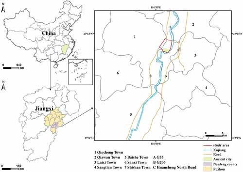
Nanfeng County, Fuzhou City, nurtured a thousand years of culture, and is the hometown of Chinese Nuo dance and of Zeng Gong. Nanfeng Ancient City is under the jurisdiction of Nanfeng County, Fuzhou City (), and is one of the most complete preserved ancient buildings in Jiangxi Province and one of the most clearly defined ancient cities of the Ming and Qing Dynasties, with four provincial-level historical and cultural districts, including Wangxian Bridge, Pangui subdivision, Xujiang west Road and Xujiang east Road. Nanfeng Ancient City is a representative of the historical city pattern at the county level of Jiangxi Province, an urban centre of Linchuan culture, and a product of the intermingling of Min and Gan culture, with high historical and cultural research value. In 2018, Nanfeng County was named a famous provincial historical and cultural city. The scope of our study is the area enclosed by the north bank of Xujiang River, Huancheng North Road, Huancheng West Road and Huancheng South Road of the Nanfeng County Urban Master Plan (2009–2030).
Figure 1. Study domain, showing the location of Jiangxi Province in China (top left), the location of Nanfeng County in Jiangxi (top right), and a close-up view of the region of interest (right).
Methodology
The theory of space syntax was proposed by Bill Hillier in the 1970s (Hillier and Hanson Citation1984). It is widely used in urban research to highlighting the effect of spatial structure on social life and exploring the impact of different spatial organizations on human activities (Lu Citation2015). The axis method of space syntax can present urban spatial structures more concisely and clearly. Here, the integration and intelligibility of the axis method are used to analyse the spatial forms and characteristics of Nanfeng City. Our methods are based on three distinct parameters.
(1) Integration. The integration degree is used to express the degree of spatial agglomeration. Integration is divided into two scales: global integration and local integration. The global integration degree indicates how closely a node is connected to all nodes in the whole system. The local integration degree describes how closely a node is connected to nodes within a certain radius. The global integration degree can be represented by , and the local integration degree can be represented by
, given by:
With:
Where: is the number of nodes of the whole system,
is the standard integration value,
is the shortest topological distance between the two points
and
, and
is the average depth value.
(2) Integrated core. In space syntax analysis, the part of the axis with higher global integration is called the integration kernel of the axis system. The distribution of the integrated core can reflect the core urban form and the basic form of a city.
(3) Intelligibility. The intelligibility is a variable that describes the relationship between local integration and global integration, and measures the extent to which local spatial structure contributes to building an understanding of the entire spatial system. The larger the intelligibility value, the easier it is to recognize the whole system. In space syntax, it is usually expressed by the regression coefficient :
where: is the average value of local integration, and
is the average value of global integration.
Data sources
The data used here comes from two sources: The first sources is from ‘Nanfeng Local gazetteers’ and survey data. The characteristics of the evolution of the urban spatial form of Nanfeng are analysed through distribution maps of current ancient buildings and historical textual data. The second source include OSM (OpenStreetMap) road vector data and Google Maps data, which are used to vectorize the urban roads of Nanfeng using Axwoman, a space syntax module in the ArcGIS software that can produce an axial map of the study area. The spatial structure evolution and development potential are studied from both global and local perspectives through variables such as integration and intelligibility. The Nanfeng urban spatial texture map is based on 2021 Nanfeng Google Map, data and drawn in Arcmap software.
The evolution characteristics of Nanfeng urban spatial form
In space syntax, the core of integration reflects the core of urban functions, and the degree of intelligibility reflects the coordination between local space and overall morphological characteristics of the city. The spatial texture reflects the changing direction of the urban interior space form. Space syntax and space texture can be combined to analyse the evolutionary characteristics of the Nanfeng urban spatial form (Xu, Wang, and Sa Citation2019).
Integration analysis
In the late Qing Dynasty, the highly integrated axis of the ancient city of Nanfeng was distributed in the centre (). This center is mainly located in the ‘cross’ street area formed by Jianshe Road, Renmin Road, Shengli Road, and Jiefang Road. With the ‘cross’ streets taken as the center, the southeastern part of the city is divided into the Xujiang East Road marketplace folklore area, the southwestern part is divided into the Xujiang West Road administrative center, the northwestern part is divided into the Wangxian Bridge religious culture area, and the northeastern part is divided into the Pangui Fang Kegong culture area. Thus, the central area of Nanfeng Old Town is connected to the peripheral area by a primary axis.
Figure 2. Maps of global integration distribution over time in Nanfeng. (a)end of the Qing Dynasty; (b) 1960; (c) 2004; (d) 2014; (e) 2021. Map lables indicate road names: Jsh: Jianshe Road, Rm: Renmin Road, Xj W: Xujiang West Road, Xj E:Xujiang East Road, Jf: Jiefang Road, Shl: Shengli Road, Chq: Chengqiang Road, Qch: Qincheng Road, Gf: Gaofeng Road, Jt: Jiaotong Road, Zg N: Zigu North Road, Zg: Zigu South Road, Csh: Cangshan Road, Jd: Judu Avenue, Xj: Xinjian Road, Jy S:Juyuan South Road, Jy N:Juyuan North Road, Xf: Xuefu Road, Nx:Nuoxiang Avenue.
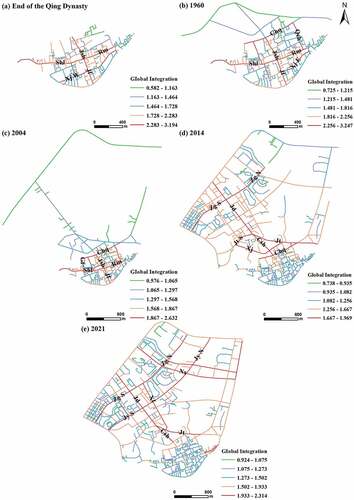
In 1960, the integrated core expanded through Jianshe Road, Renmin Road, Jiefang Road, and Shengli Road, the integrated core coverage expanded to Chengqiang Road and Qincheng Road, and to the northeast. In 2004, the integration core expanded to the north of Shengli Road and Renmin Road, forming a new core consisting of Shengli Road, Renmin Road, Jianshe Road, Chengqiang Road and Qincheng Road, extending to both sides of the ancient city. In 2014, the integration core expanded to the northwest, and the new city expanded north through Cangshan Road, forming an axis with Judu Avenue, and extending outward along Zigu Road, Juyuan North Road, Jiaotong Road, and City Wall Road. As of 2021, the scope of the ancient city is no longer the integrated centre of the city. The new city is defined with Judu Avenue and Nuoxiang Avenue as the vertical axis, and with Zigu Road and Juyuan North Road as the horizontal axis of the mesh structure, following along the core of the integrated core outward expansion.
The core of local integration of Nanfeng Ancient City at the end of Qing Dynasty was mainly located in the large and small ‘cross’ street structure formed in the centre (). The highest global integration degree and local integration degree are the axis areas where Shengli Road, Renmin Road, Jianshe Road, and Jiefang Road are located, indicating that the space represented by them is the core of the overall space of the Nanfeng Ancient City and is also the core of the local space of the ancient city.
Figure 3. Maps of local integration degree distribution over time in Nanfeng. (a) End of the Qing Dynasty, (b) 1960; (c) 2004; (d) 2014; (e) 2021. Map lables indicate road names: Jsh: Jianshe Road, Rm: Renmin Road, Xj W: Xujiang West Road, Xj E:Xujiang East Road, Jf: Jiefang Road, Shl: Shengli Road, Chq: Chengqiang Road, Jt: Jiaotong Road, Jt S:Jiaotong South Road, Zg N: Zigu North Road, Zg S: Zigu South Road, Csh: Cangshan Road, Jd: Judu Avenue, Xj: Xinjian Road, Jy S:Juyuan South Road, Jy N:Juyuan North Road, Xf: Xuefu Road, Nx:Nuoxiang Avenue.
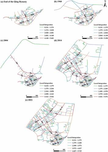
In 1960, the network density along Jianshe Road and Cangshan Road increased, and the local integration degree of Jiaotong Road and Xinjian Road increased northward. In 2004, Nanfeng had a new local core along Judu Avenue, Jiaotong Road and Xinjian Road. In 2014, the new city was formed with Judu Avenue and Nanguang Road as its local core, which extended to both sides along Zigu Road and Jiaotong Road. In 2021, Judu Avenue, Zigu South Road, Juyuan South Road and Nanguang Road will forms the local core of the northwest part of the ancient city, and Nuoxiang Avenue, Zigu North Road, and Juyuan North Road forms the northern part of the core, with increased local integration and increased density of the new city.
The changes in the core of local integration from the end of Qing Dynasty to 2021 can suggest the integration degree and development trends. The development of local integration centres on the original basis, and the core of new local integration expands to the northwest of the ancient city. A network structure with Judu Avenue, Nuoxiang Avenue, Xuefu Road, and Qinhu Middle Road as the vertical axis, and Zigu Road and Juyuan Road as the horizontal axis is now the new local core.
Intelligibility analysis
Nanfeng city () shows an intelligibility of 0.6663, 0.5917, 0.3351, 0.4656 and 0.4799 during the five periods considered here, with the intelligibility of the city decreasing and then slowly increasing over time.
Figure 4. Spatial intelligibility scatterplots of Nanfeng City during: (a) End of the Qing Dynasty; (b) 1960; (c) 2004; (d) 2014; (e) 2021. Trendlines are R2 values are given in each subplot.
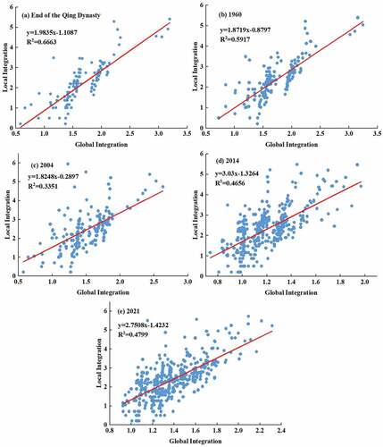
In the late Qing Dynasty, Nanfeng Ancient City was clustered with strong internal correlation. In 1960, the northern wall of Nanfeng Ancient City was demolished, and the scope of the city expanded to the north. The scale of the city expanded outward, and the intelligibility of the urban form relative to the ancient city in the late Qing Dynasty began to decline. By 2004, with the expansion of the city, the new city developed independently of the ancient city, and the local relevance of the new city increased, while the overall relevance of the new city and the ancient city decreased. The intelligibility of Nanfeng city in 2014 slowly increased. With the construction of transportation facilities and the increase of socio-economic activities, the intelligibility of Nanfeng city continued its development. The expansion of Nanfeng expanded to the east in 2021. The new city is in an orthogonal grid pattern.
Spatial texture analysis
The scope of the ancient city of Nanfeng has expanded and its location has been moved. The integrated nucleus of the new city has developed along a clearly defined axis. The location of the global integrated core expanded with the newly expanded area on the base of the original integrated core and has merged to form a new centre ().
Figure 5. The comparison of spatial textures of the ancient Nanfeng City and the new Nanfeng City.
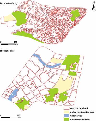
The urban space of Nanfeng in 1960 divides into two parts, the old city and the new city. The urban network of the old city and the new city are different in terms of local characteristics. The southeastern part of the ancient city is more densely built, while the northwestern edge is relatively sparse. The internal roads of the ancient city neighbourhood are designed for residential users, with a relatively clear functional zoning. The urban master plan of Nanfeng new city laid out plans for residential, commercial, and other buildings, which are regularly distributed according to land function. The internal roads of residential land are not completely opened to the outside, which constrains their public usability. Therefore, the old city dominates in the dense space and maintains centrality in the urban agglomeration expansion space. The new city appears sparse, with weak relationships between the perimeter and internal road topology of residential areas and weak connections to the main urban roads. The central area of human and vehicular traffic leads to an increase in traffic pressure, thus, the development of the old city cannot meet the existing development needs of the city. In addition, the process of outward urban road expansion outward has brought more local centrality to the overall network.
The Nanfeng Ancient City urban centre shifted to the north of the city with development, and morphological changes brought about an integrated nucleus change. The city now has a regular spatial grid, with urban expansion occurring along the original main road on a stretching axis, with spatial elements filling in under the urban framework formed by the stretching axis, ultimately forming an encrypted urban grid form.
Evolutionary characteristics and causes of the Nanfeng urban spatial form
The evolution of urban spatial form is the result of the interaction of various factors such as nature and society. Natural and social factors are selected to analyse the causes of the evolution of Nanfeng urban form according to its local characteristics (Lou Citation2018).
Natural factors
The natural environment is the basis for the emergence and development of urban form. The east, southeast, west, and northwest of Nanfeng are surrounded by mountains, and the Xujiang River flows from the east, west, and south of the ancient city, forming a pattern of ‘The mountains are behind it and the water is in front of it’. (Ma and Su Citation2020). The urban spatial form gradually expands to the north with the Xujiang River as the boundary.
Social factors
During the Yuan Dynasty, Nanfeng City was upgraded to a state government in order to strengthen the marginal rule. The city wall has built at that time, and economic and social activities promoted the continuous development of the ancient city. The spatial form of Nanfeng Ancient City was within the scope of the ancient city wall due to the ancient ‘camp city’ system and the surrounding landscape, which yielded a ‘cross’ street structure with Jianshe Road, Renmin Road, Shengli Road and Jiefang Road, which divided the ancient city into four corners and nine squares. The inner city has obvious agglomeration.
Since the end of the Qing Dynasty, there have been many wars, and Nanfeng has become self-sufficient in its production and complete in its infrastructure, as well as being a refuge for surrounding cities and towns. However, the original urban scale can no longer meet the needs of living and production due to an increase of the local population. In 1960, the northern city wall of Nanfeng Ancient City was demolished, and a city wall road and a traffic road were built, allowing the city to expand northward along through the road axis. The city extended outward in a branch-like shape through its the integrated core, the coverage of the integrated core further expanded, and the northeast expansion of the ancient city began.
The overall urban planning of Nanfeng County promulgated, and the internal roads of the city continued. The city formed with the connection of Judu Avenue-Cangshan Road as an expansion axis, and expanded on both sides of the axis. As of 2021, the distribution range of integrated cores continues to expand outward in a grid-like manner. The continuous improvement of the new city form, along the new city axis has become saturated, and the new city has expanded from the east to the south along the Xujiang River. The changes during the five periods of urban expansion and evolution in Nanfeng are given in table ():
Table 1. Analysis of the Evolutionary Laws and Causes of the Urban Form of Nanfeng City.
In general, the evolution of the Nanfeng urban spatial form has gone from an agglomeration development to an axial development, and then to a decentralized development stage. The expansion direction of the spatial form of the ancient city and of the integrated core centre were first to the northwest and then to the northeast.
Discussion & conclusion
Discussion
Our findings suggest the following recommendations for the protection and development of the ancient city: First, improve the spatial texture of the ancient city and plan the spatial organization. The ancient city of Nanfeng has a long history of development. It is desirable to protect the traditional natural and humanistic appearance of the ancient city in the Ming and Qing dynasties. Therefore, infrastructure and iconic landscapes should be improved to promote the development of tourism in the ancient city and enhance the overall spatial perception of tourists. urban development needs to carry out the overall planning of the new city under the premise of protecting the development of the ancient city, which will make the urban spatial structure more reasonable. Second, the new city should reasonably plan urban roads, reasonably lay out urban land types, optimize the urban spatial layout, and improve regional traffic accessibility and regional connectivity. Finally, rational planning of traffic roads could link the development of the old city and the new city through traffic roads, improve the spatial continuity and promote the economic development of the old city.
We here analysed the spatial morphology of Nanfeng through space syntax, which may provide guidance for other cities and related urban research. Analysis of the overall spatial form of a city (Jeong, Lee, and Ban Citation2017), and evaluation of urban development history (Günaydin and Yücekaya Citation2020) such as planning and design of rail transit stations (Hoeven and Nes Citation2014), green space accessibility (Li, Ni, and Dewancker Citation2019), street networks (Bindajam and Mallick Citation2020), and configuration of urban public service facilities (Rybarczyk and Wu Citation2014) provide reference for overall and local spatial analysis and planning of the city.
Our approach has a few limitations. First, when building the spatial axis model, the road width of ancient buildings preserved in Ming and Qing dynasties is different from the existing road width, and some of them cannot be shown on the image and vector map. Therefore, some of the axes are manually self-drawn, which may have influence on the results. Second, the low resolution of early remote sensing images and the low recognition of new narrower roads in the city may also influence results. Finally, research on the development of tourism in the ancient city and the political and economic aspects of the new city on the urban impact is relatively brief, and further study of these aspects is planned in future research.
Conclusion
We analysed of the spatial morphological variables and spatial morphological evolution characteristics of Nanfeng City through the theory of space syntax, drawing the following conclusions:
The overall shape of Nanfeng Ancient City has gone through stages of agglomeration development, axials development and decentralized development over time. The city has developed from a concentrated development in the south to a scattered development along the axis to the north. The local morphology of the present city has been, influenced by the spatial form of the ancient city, as a horizontal axis network-like pattern of outward expansion.
The pattern of the local and overall spatial morphology evolution of Nanfeng City has expanded northward along the axis due to the mutual traction and impetus between the external space and the internal core of the ancient city. The direction of urban spatial expansion is consistent with the development direction of the integrated core centre, and the transfer of the urban center is synchronized with the spatial morphology evolution. The evolution of urban spatial form shows an evolutionary pattern from line to surface and from centralized to decentralized development.
The Nanfeng urban spatial form is quasi-orthogonal, and since the end of the Qing Dynasty, the urban centre has expanded along the axis to the north, and the city has expanded to form a new core. The ancient city dominates in the dense space and has a local centrality in the urban agglomeration expansion space. The new city fabric appears sparse, and local networks and process of outward expansion of urban roads has brought more local centrality to the overall network.
Space syntax can be used to analyse the characteristics of urban spatial morphology via integration degree and intelligibility. It is effective in the analysis of urban centre transfers and integration kernel change. However, due to the influence of river topography and roads, the deviation of the boundary area leads to ‘edge effects’. Future work will consider cut-off distance or local radius to eliminate the ‘edge effect’. In addition, we will use Pearson and Spearman correlation to measure their differences. A boundary buffer defined by different methods can improve the analysis of urban spatial form (Gil Citation2017).
Acknowledgements
The authors appreciate senior schoolmates, English revision teacher and reviewers for their comments on revisions to this article.
Disclosure statement
No potential conflict of interest was reported by the author(s).
References
- Baumanova, M. 2020. “Sensory Synaesthesia: Combined Analyses Based on Space Syntax in African Urban Contexts.” African Archaeological Review 37 (1): 125–141. doi:10.1007/s10437-020-09368-9.
- Bella, E.-D., M. Corsi, L. Leporatti, and L. Persico. 2017. “The Spatial Configuration of Urban Crime Environments and Statistical Modeling.” Environment and Planning B: Urban Analytics and City Science 44 (4): 647–667. doi:10.1177/0265813515624686.
- Bindajam, A.-A., and J. Mallick. 2020. “Impact of the Spatial Configuration of Streets Networks on Urban Growth: A Case Study of Abha City, Saudi Arabia.” Sustainability 12 (5): 1856. doi:10.3390/su12051856.
- Chen, M.-X., C. Ye, D.-D. Lu, Y.-W. Sui, and S.-S. Guo. 2019. “Cognition and Construction of the Theoretical Connotations of New Urbanization with Chinese Characteristics.” Journal of Geographical Sciences 29 (10): 1681–1698. doi:10.1007/s11442-019-1685-z.
- Chiang, Y.-C., and Y. Deng. 2017. “City Gate as Key Towards Sustainable Urban Redevelopment: A Case Study of Ancient Gungnae City Within the Modern City of Ji’an.” Habitat international 67: 1–12. doi:10.1016/j.habitatint.2017.06.007.
- Choi, A.-S., Y.-O. Kim, E.-S. Oh, and Y.-S. Kim. 2006. “Application of the Space Syntax Theory to Quantitative Street Lighting Design.” Building and Environment 41 (3): 355–366. doi:10.1016/j.buildenv.2005.01.026.
- Chu, K.-F., and M.-Y. Wu. 2022. “The Traditional Settlement Planning and the Renovation of Residential Buildings Based on Spatial Syntax Analysis.” Soft Computing 26 (16): 7809–7815. doi:10.1007/s00500-022-06796-4.
- Dai, J.-L., X.-L. Gao, and S.-S. Du. 2010. “Spatial Expansion and Land Use Control in the Urbanization Process.” Geographic Research 29 (10): 1822–1832.
- Esposito, D., S. Santoro, and D. Camarda. 2020. “Agent-Based Analysis of Urban Spaces Using Space Syntax and Spatial Cognition Approaches: A Case Study in Bari, Italy.” sustainablility 12 (11): 4625. doi:10.3390/su12114625.
- Fang, K., X.-P. Wang, W.-D. Zhang, Z.-H. Zhang, Y.-F. Xie, L. Chen, G.-Q. Zhu, and N. Furuya. 2020. “Characteristics of Space Network System Formed by the Constituent Elements in Urban Streets: Tianzifang in Shanghai as a Case Study.” Journal of Asian Architecture and Building Engineering 20 (6): 626–639. doi:10.1080/13467581.2020.1803078.
- Fladd, S.-G. 2017. “Social Syntax: An Approach to Spatial Modification Through the Reworking of Space Syntax for Archaeological Applications.” Journal of Anthropological Archaeology 47: 127–138. doi:10.1016/j.jaa.2017.05.002.
- Gil, J. 2017. “Street Network Analysis “Edge Effects”: Examining the Sensitivity of Centrality Measures to Boundary Conditions.” Environment and Planning B: Urban Analytics and City Sciences 44 (05): 819–836. doi:10.1177/0265813516650678.
- Günaydin, A.-S., and M. Yücekaya. 2020. “Evaluation of the History of Cities in the Context of Spatial Configuration to Preview Their Future.” Sustainable Cities and Society 59: 102202. doi:10.1016/j.scs.2020.102202.
- Guo, Y.-C., G.-X. Tian, R. Zhao, X.-J. Shen, B.-B. Dong, and R.-Z. He. 2019. “A Study of Spatial Form Changes in Major Cities in China, 2000-2013.” Journal of Southwestern University (Natural Science Edition) 41 (05): 139–148. doi:10.13718/j.cnki.xdzk.2019.05.020.
- Haq, S. 2019. “Where We Walk is What We See: Foundational Concepts and Analytical Techniques of Space Syntax.” Herd-Health Environments Research & Design Journal 12 (1): 11–25. doi:10.1177/1937586718812436.
- Haq, S., and Y. Luo. 2012. “Space Syntax in Healthcare Facilities Research: A Review.” Herd-Health Environments Research & Design Journal 5 (4): 98–117. doi:10.1177/193758671200500409.
- Hillier, B., and J. Hanson. 1984. The Social Logic of Space: Index. Cambridge: Cambridge University Press.
- Hoeven, F. V. D., and A. V. Nes. 2014. “Improving the Design of Urban Underground Space in Metro Stations Using the Space Syntax Methodology.” Tunnelling and Underground Space Technology 40: 64–74. doi:10.1016/j.tust.2013.09.007.
- Huang, B.-X., S.-C. Chiou, and W.-Y. Li. 2021. “Landscape Pattern and Ecological Network Structure in Urban Green Space Planning: A Case Study of Fuzhou City.” Land 10 (8): 769. doi:10.3390/land10080769.
- Jeong, S.-K., T.-H. Lee, and Y.-U. Ban. 2017. “Characteristics of Spatial Configurations in Pyongyang, North Korea.” Habitat international 47: 148–157. doi:10.1016/j.habitatint.2015.01.010.
- Jiang, Y.-C., L.-J. Sun, T.-T. Wang, X. Fang, and L. Sun. 2021. “The Relationship Between Crime Distribution and Urban Environment in the Central City of Lanzhou.” Mapping Science 46 (05): 167–174. doi:10.16251/j.cnki.1009-2307.2021.05.023.
- Joo, Y., and Y. Kwon. 2020. “Evaluating the Consequences of Supergrid Developments with Relation to the Modernization and Conservation of Historic Street Patterns: A Case Study on Early 20th Century Seoul.” Journal of Asian Architecture and Building Engineering 1: 1–15. doi:10.1080/13467581.2020.1838909.
- Li, Y., J.-X. Huang, and L.-C. Yang. 2020. “From Functional Space to Experience Space: Applying Space Syntax Analysis to a Museum in China.” International Review for Spatial Planning and Sustainable Sustainable Development A: Planning Strategies and Design Concepts 8 (2): 86–99. doi:10.14246/irspsda.8.2_86.
- Li, X., Z.-H. Lv, Z.-G. Zheng, C. Zhong, I.-H. Hijazi, and S.-D. Cheng. 2017. “Assessment of Lively Street Network Based on Geographic Information System and Space Syntax.” Multimedia Tools & Applications 76 (17): 17801–17819. doi:10.1007/s11042-015-3095-2.
- Li, X.-Q., G.-P. Ni, and B. Dewancker. 2019. “Improving the Attractiveness and Accessibility of Campus Green Space for Developing a Sustainable University Environment.” Environmental Science and Pollution Research 26 (32): 33399–33415. doi:10.1007/s11356-019-06319-z.
- Liu, R.-Q., H. Xi, and W.-X. Han. 2020. “Construction, Conservation and Development of Historical Town Spaces Under Cultural and Ecological Changes.” Urban Development Research 27 (11): 38–43.
- Li, H., Z.-D. Wang, X. Wei, Z.-C. Sun, C.-G. Su, L. Xiao, and Z.-Y. Lu. 2020. “Evolution of Regional Economic Pattern and Optimization of Spatial Strategic Structure in Hunan Province.” Economic geography 40 (11): 39–46+85. doi:10.15957/j.cnki.jjdl.2020.11.005.
- Lou, X.-F. 2018. Study on the Evolution and Influencing Mechanism of Urban Spatial Form in Dangtu County. Nanjing: Southeast University.
- Lu, T. 2015. Study on the Design Strategy of Spatial Form of Northeastern Villages Based on Spatial Syntax. Harbin: Harbin Institute of Technology.
- Lu, S.-W., Y.-P. Huang, and Z.-F. Zhao. 2021. “Analysis of the Correlation Between Spatial Form and Neighborhood Vitality in the Main Urban Area of Chengdu.” Geographical Research and Development 40 (01): 73–77.
- Ma, K., and J.-F. Su. 2020. “Study on the Protection and Development Value of Nanfeng County Historical and Cultural City in Fuzhou City.” Architecture and Culture 2: 206–207.
- Medeiros, V., and F.-D. Holanda. 2010. “Brazilian Cities: Fragmentary Space, Patchwork and Oasis in the Labyrinth.” Urban Design International 15 (2): 73–89. doi:10.1057/udi.2009.18.
- Morales, J., A. Stein, J. Flacke, and J. Zevenbergen. 2020. “Predictive Land Value Modelling in Guatemala City Using a Geostatistical Approach and Space Syntax.” International Journal of Geographical Information Science 34 (7): 1451–1474. doi:10.1080/13658816.2020.1725014.
- Nahyang, B., and C. Jaepil. 2016. “A Typology of Korean Housing Units: In Search of Spatial Configuration.” Journal of Asian Architecture and Building Engineering 15 (1): 41–48. doi:10.3130/jaabe.15.41.
- Omer I and Goldblatt R. (2017). Using space syntax and Q-analysis for investigating movement patterns in buildings: The case of shopping malls. Environment and Planning B: Urban Analytics and City Science, 44(3), 504–530. 10.1177/0265813516647061
- Othman, F., Z.-M. Yusoff, and S.-A. Salleh. 2020. “Assessing the Visualization of Space and Traffic Volume Using GIS-Based Processing and Visibility Parameters of Space Syntax.” Geo-Spatial Information Science 23 (3): 209–221. doi:10.1080/10095020.2020.1811781.
- Rybarczyk, G., and C. Wu. 2014. “Examining the Impact of Urban Morphology on Bicycle Mode Choice.” Environment and Planning B: Planning & Design 41 (2): 272–288. doi:10.1068/b37133.
- Sadek, A. H., and M. M. Shepley. 2016. “Space Syntax Analysis: Tools for Augmenting the Precision of Healthcare Facility Spatial Analysis.” Herd-Health Environments Research & Design Journal 10 (1): 114–129. doi:10.1177/1937586715624225.
- Wang, F., J. He, C.-Y. Jiang, and Y.-X. Li. 2018. “Evolution of the Commercial Blocks in Ancient Beijing City from the Street Network Perspective.” Journal of Geographical Sciences 28 (6): 845–868. doi:10.1007/s11442-018-1509-6.
- Wang, S.-J., R.-J. Wang, Y.-C. Wang, and C.-Y. Liu. 2012. “Analysis of Urban Spatial Form Evolution in Daqing City Based on RS and GIS.” Economic Geography 32 (06): 67–73.
- Xu, Y.-F., D.-G. Wang, and M.-Y. Sa. 2019. “The Evolution and Influence Mechanism of Suzhou Urban Spatial Form from the Perspective of Two Dimensions.” Economic Geography 39 (04): 75–84. doi:10.15957/j.cnki.jjdl.2019.04.010.
- Yamu, C., A. V. Nes, and C. Garau. 2021. “Bill Hillier’s Legacy: Space Syntax—a Synopsis of Basic Concepts, Measures, and Empirical Application.” Sustainability 13 (6): 1–25. doi:10.3390/su13063394.
- Yoo, C.-S., and S.-G. Lee. 2017. “When Organic Urban Forms and Grid Systems Collide: Application of Space Syntax for Analyzing the Spatial Configuration of Barcelona, Spain.” Journal of Asian Architecture and Building Engineering 16 (3): 597–604. doi:10.3130/jaabe.16.597.
- Zhang, D., C.-H. Shi, and L.-R. Li. 2022. “Study of the Differences in the Space Order of Traditional Rural Settlements.” Journal of Asian Architecture and Building Engineering 1–15. doi:10.1080/13467581.2022.2046591.
- Zhao, P.-J., and Y.-T. Jia. 2018. “Measurement of Small Town Settlement Patterns and Their Laws in China.” Research on Urban Development 25 (12): 90–99.
- Zhou, Q.-H., and Z.-Q. Liu. 2021. “Research on the Optimization Strategy of Shopping Mall Spatial Layout in Hefei Based on Space Syntax Theory.” Complexity 2021: 1–9. doi:10.1155/2021/5535738.
- Zwirowicz-Rutkowska, A., and A. Michalik. 2016. “The Use of Spatial Data Infrastructure in Environmental Management: An Example from the Spatial Planning Practice in Poland.” Environmental management 58 (4): 619–635. doi:10.1007/s00267-016-0732-0.