
 ?Mathematical formulae have been encoded as MathML and are displayed in this HTML version using MathJax in order to improve their display. Uncheck the box to turn MathJax off. This feature requires Javascript. Click on a formula to zoom.
ABSTRACT
In the study carried out in the Ordu province of Turkey, 16 criteria to be used in airport site selection were handled and evaluated by subjecting them to successive processes in the GIS environment. Each criterion was weighted with the AHP method, and a map of suitability for airport site selection was obtained in the GIS environment using these weights. The most suitable place for the airport in Ordu province was detected by evaluating the nine regions determined according to the resulting map. Then, the alternative areas preferred from the most suitable areas were evaluated according to the total scores from the classification intervals with a scenario where the criterion weights were assumed to be equal. Finally, sensitivity analysis was performed to identify those who played an active role in the site selection analysis or not. Thus the sensitivity of the site selection analysis was tested.
1. Introduction
Transportation; It can be defined as the transfer or transit of goods, objects, or people from one area, region, country, or continent to another. Transportation, which dates back to the first years of human history, is essential because it is one of the primary activities in meeting many of our needs in our lives. Today, transportation activities are used intensively to realize social, economic, cultural, technological, and environmental needs. It is possible to say that it plays a primary role in globalization and development and provides an environment for realizing spatial communications and interactions in our world.
Population movements, urbanization, economic changes, and growth experienced after the industrial revolution formed people and objects to carry out intensive transportation activities. This situation has revealed various types of transportation and vehicles over time. The highway was first used for transportation purposes. Then, sea and rail transportation started. Finally, with the Wright brothers’ first powered flight in 1903, air transportation was opened (Anderson Citation2000). Air transport was first used in the military field. Then it started to become widespread, first in the commercial field and then in daily life. It has enabled the transportation of goods in the commercial field and passengers in daily life between cities, countries, and continents. Over time, air transport has developed and continues to evolve. Due to its speed, it is time-saving and comfortable, which makes air transportation preferable.
The use of airplanes for militagry purposes in the First World War paved the way for the beginning of a new era in air transportation (Bakırcı Citation2012). Airlines’ use for civil and commercial purposes has become widespread (Tümertekin Citation1987). Over time, passengers started to be transported between Europe and the USA by air, and this situation spread first to all western countries and then to almost all countries (Doğanay Citation2011). The beginning of air transportation in Turkey has been parallel to many countries worldwide. Immediately after the Second World War, aviation activities in Turkey gained momentum, and the development process was started. Turkey’s geographical location, connecting two continents, and many geographical features have contributed significantly to this process (Bakırcı Citation2012).
Airports are one of the most basic and essential parts of air transportation. They are the centres that allow the landing and take-off movements during air transportation and provide the necessary infrastructure for the flight operations of passengers and cargoes (Annex Citation2006). These centres, which have a complex layout, contain many activities. Airports consist of runways, aprons, boarding gates, taxiways, passenger and freight terminals, and ground transportation units (Graham Citation2008). Large areas are needed to establish these centres with a comprehensive infrastructure, which requires a significant investment cost. In order to ensure efficiency in both aspects, it is of great importance that the airport site selection is made most appropriately.
Several criteria are considered in the site selection of airports. These are climate, topography, airspace, land environment and infrastructure possibilities, and other features under these headings. By examining each criterion and then considering this evaluation as a whole, the most suitable location for airports can be selected. Various methods are used in site selection studies. In this context, the Analytical Hierarchy Process (AHP), one of the Multi-Criteria Decision Making (MCDM) methods, is one of the most frequently applied methods. This method handles complex problems in the form of a hierarchical structure. It is based on the logic of pairwise comparison (Saaty Citation1989). The AHP aims to determine the most suitable option or rank the suitability of more than one option that is thought to be suitable. In other Words, the AHP method has been used frequently to solve complex decision-making problems. In realizing this purpose, the essential criteria in site selection play the leading role and ensure the implementation of the method.
While airports form the basis for air transportation, they also bring economic, social, and environmental effects locally and regionally. Its main economic impacts are the revival of tourism in cities, countries, and even continents, making trade dynamic, investment opportunities utilizable, and creating employment opportunities. The vitality in cultural shopping, the increase in accessibility, the rise in welfare, and thus the changes in the demographic structure can be mentioned as social effects. On the other hand, although airports revitalize the region they are located in economically and socially, they bring some environmental problems. In this context, air and noise pollution are among the main problems. It is important to make the most suitable site selections from many aspects considering all these airports’ effects.
Other issues to be considered in airport site selection studies; the practices put forward by both national and international organizations established to provide specific standards and unity in the field of aviation, and the legislation on the execution of activities in this field. The International Civil Aviation Organization (ICAO), which was established for this purpose, it aims to organize, develop and sustain the international aviation industry in a systematic, economical, and secure manner (Oyman Citation1998). As a party to the Chicago Convention, Turkey took part in the establishment of ICAO and was subject to organization’s practices (Erdağı Citation1994). On the other hand, many legislations represent the aviation industry nationally in Turkey. Both other countries and Turkey should consider the standards and rules of the organizations and legislation they are affiliated within their studies in this field.
In literature, various studies have been carried out from the past to the present on airports’ location and site selection. It has been seen that some of these studies use the AHP method, while others use other methods. Kıanısadr (Citation2019) carried out an airport location selection study using TOPSIS, one of the MCDM methods, in his study in Tehran, Iran. The suitability map of the study area was produced with the study based on 5 environmental factors. Suitability was evaluated by dividing it into 4 classes. Alves et al. (Citation2020) produced and presented a general methodology for the airport site selection process with their study. The criteria for site selection were determined by evaluating the results of the studies in the literature, and they were weighted by evaluating these criteria with AHP, one of the MCDM methods. In general, the study reveals the process of determining the necessary criteria and obtaining the weights of these criteria by evaluating the results of the studies in the literature. Zhao and Sun (Citation2013) conducted a study in Chengdu, China, using the Multi-Objective Lattice Order Decision Making method. They evaluated 3 alternative areas selected for the airport. This method evaluates the decision process with the lattice layout. Han et al. (Citation2022) conducted a site selection study for an airport to be used for emergencies in the Yangtze River Delta in Shanghai, China. There is no site selection study for emergency airports in the literature. In this respect, it is unique in the literature. The location selection was based on the compatibility with the global grid system, and the application was carried out based on the GeoSOT-3D global grid model. The method used in the study is also different from those in the literature. With this study, the effectiveness of the method was evaluated and a study was carried out for disasters. Erkan and Elsharida (Citation2020) carried out an airport site selection study in Libya. In this study, based on 23 criteria, a GIS-based evaluation was made using AHP and ROC methods. Finally, the results obtained from two different methods were compared and the reliability of the outputs was tested with sensitivity analysis. Ertunç and Çay (Citation2020), carried out an airport site selection study for the provinces of Bayburt and Gümüşhane. For this purpose, the AHP method was used as GIS-based and a comparison was made with the region where the existing airport construction is located. It was seen that the determined area and the current location were the same, so the study was confirmed. Oktal (Citation1998), in his study, made a suggestion by creating an airport location model for Eskişehir and its surroundings. In the study, the parameters to be used in airport location selection were determined and a model was created with the help of GIS. All the necessary information about the study area was recorded in a database, using this information in the GIS environment, the candidate location were evaluated and then the appropriate location was determined. Akça (Citation2017) conducted a scale development study. With this study, it has been determined that the suitability of the airport location depends on which factors and under which headings these factors will be collected. During the study, the views of air traffic controllers were used. As a result of the evaluations, it has been revealed that the ‘airspace structure, meteorological conditions and physical suitability’ factors are the most basic and determining factors for the suitability of the airport location. Özür (Citation2018) examined the locations of the airports established in Turkey and the land use of these places, and evaluated their suitability. As a result of the examination, it was concluded that 60% of the existing airports were built on agricultural areas. Başer (Citation2019) evaluated the effects of the current location of Ordu-Giresun Airport on the environment and the real estate properties around it. Thus, the results of the location selections for the airports were evaluated. On the other hand, Özdağoğlu, Keleş, and Işıldak (Citation2021)used PIPRECIA-E, SMART and MARCOS techniques from MCDM methods in their studies. With these techniques, the performances of the world’s busiest airports were evaluated. The analysis was carried out by considering the density of the airports, the number of departing and arriving aircraft, the number of passengers and transportation activities. Weights were determined with the PIPRECIA-E technique, and airports were listed with SMART and MARCOS techniques. Türk (Citation2015) evaluated the suitability of the location of Ordu-Giresun airport. In this process, the geographical features, economic characteristics, natural and human characteristics of the region were discussed. An evaluation has been made by revealing the contribution and possible risks that will be made to the environment after the airport becomes operational. Ballis (Citation2003) conducted a site selection study for a new airport location on the Greek island of Samothraki. In this context, AHP, one of the MCDM methods, was used. First of all, alternative places were determined by considering land use, wind, weather conditions, road network, safety, soil, environmental-economic-social factors. Then, the most suitable location was selected. (Palczewski and Sałabun Citation2019) carried out a study on different normalization techniques using one of the MCDM methods, PROMETHEE II. An experimental study was conducted on airport site selection using ten alternatives and seven criteria. In this study, it was investigated whether different normalization processes cause different rankings. (Zhao et al. Citation2019) conducted a study to guide the civil airport expansion plan for Dalian, China. The study was based on the protection of bird ecology, the criteria were selected according to this situation, and a proposal was made that emphasizes ecological protection for airport location selection with AHP, one of the MCDM methods. Apart from these studies, it is possible to come across many similar publications. (Bambiger and Vandersypen Citation1969; Belbağ, Deveci, and Uludağ Citation2013; Cai and Zhang Citation1996; Ding et al. Citation2011; Fu et al. Citation2016; Huang et al. Citation2013; Kassomenos, Panagopoulos, and Karagiannis Citation2005; Liao and Bao Citation2014; Martel and Aouni Citation1992; Min Citation1994; Min, Melachrinoudis, and Wu Citation1997; Paelinck Citation1977; Sennaroglu and Varlik Celebi Citation2018; Togatlian, Correia, and Belderrain Citation2006; Van Der Kleij, Hulscher, and Louters Citation2003; Wang et al. Citation2009; Yang, Wu, and Liao Citation2014).When the literature is examined, it is seen that the studies on this subject have been carried out in long time intervals. While the first studies were mostly theoretical, recent studies are application-oriented. The main focuses of these studies are; determining the criteria that are important for airport location selection, determining alternative and most suitable locations, and evaluating the environmental, economic and social impacts of airports. MCDM methods are generally preferred in applications.
The studies in the literature are not comprehensive and have been carried out based on a specific focus. On the other hand, in the majority of studies, analyzes to test the reliability of the results were not performed. This study was carried out in a wide perspective. The aim of the study is to serve the province of Ordu; It is the determination of alternative places for the airport and the most suitable one among these places. For this purpose, the most decisive criteria for airport location selection were determined through a comprehensive research, alternative and most suitable locations were determined with AHP, one of the MCDM methods, and the accuracy of the criteria and the obtained outputs were analysed with sensitivity analysis. Today, there is an airport that is used jointly for the provinces of Ordu-Giresun, which was recently completed and opened for operation. With this study, an evaluation was made for the airport location selection on the province of Ordu, on the one hand, the suitability of the existing airport location was evaluated, on the other hand, it was aimed to add a different perspective to similar studies to be done in the future by presenting a new model. In almost all of the existing studies, the AHP method or a different method was used alone and the maps produced from the outputs were not visualized in detail. In this study, the results obtained from the AHP method were supported by sensitivity analysis and all outputs were visualized by producing detailed maps with the support of GIS. In addition, satellite images were used to provide a better understanding of the region. The addition of sensitivity analysis to the study enabled both the AHP method and the results obtained to be tested. Thus, the basis for revealing the deficiencies that may arise from the method has been established. All the mentioned details show the difference of this study from the existing studies and its contribution to the literature.
With this study, which was carried out in Ordu, Turkey, it was aimed to bring the airport location decision into a logical form with AHP, one of the MCDM methods, the results were evaluated with sensitivity analysis and the obtained outputs were supported by GIS.
2. Material and methods
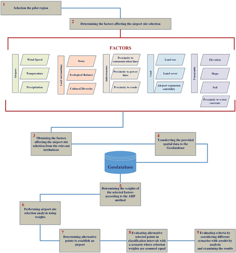
This study examines the airport site selection analysis in a selected pilot region. The general workflow chart applied in performing the analysis is shown in . The first step in the realization of the study is selecting the pilot region. The second step is to determine the factors affecting the airport site selection in the pilot region and create a geographic database by obtaining the data of the factors from the relevant institutions. The third step is to determine the factor weights of the selected factors based on the Analytical Hierarchy method, one of the MCDM methods. The fourth stage is to perform airport site selection analysis in the pilot region using factor weights and determine alternative locations where the airport will be established. In the fifth stage, the alternative selected locations are evaluated according to the total scores from the classification intervals with a scenario where the criterion weights are assumed equal. The last stage of the study is to evaluate the criteria with different scenarios by making sensitivity analyses and examining the results.
Figure 1. Workflow chart of the study.
The study was carried out using Analytical Hierarchy Method (AHP), which are Multi-Criteria Decision Making Methods, Geographic Information Systems (GIS), and Sensitivity Analysis methods.
2.1. Multi-Criteria Decision-Making Methods (MCDM)
While choosing the appropriate one among various alternatives, evaluation is made with different criteria, and the most accurate one is decided. It is essential to make an intuitive and sometimes analytical decision in the encountered problems. Intuitive decisions are often made on the fly, without analysis and comparisons. If information is not needed in typical situations, quickly, intuitive decisions can be successful. In other cases, that is, in problems that need information and require analysis and comparisons, intuitive decisions will not lead to the desired goal. The problem’s solution may deviate from the target, which leads to the wrong decision. On the other hand, analytical decisions are the selection of the option that best meets the desired result due to the analysis, classification, and interpretation of the available data for the problem. With the development of this analytical decision process, multi-criteria decision-making methods have emerged (Karabıçak et al. Citation2016).
Multi-criteria decision-making methods aim to reach the optimum result in the shortest time by evaluating the alternatives and minimizing the complexity of the criteria. As can be understood, multi-criteria decision-making methods should be used in decision problems involving multiple criteria, such as airport site selection. Multi-criteria decision-making methods can be grouped under three headings as selection, classification, and ranking problems (Karabıçak et al. Citation2016).
Selection problems are selecting the most suitable alternative from among many alternatives. Classification problems are the combination of alternatives according to specific criteria or demand. On the other hand, ranking problems are ordering alternatives from good to bad or vice versa. The methods covering these problems are shown in , respectively.
Figure 2. Multi Criteria Decision Methods (Karabıçak et al. Citation2016).
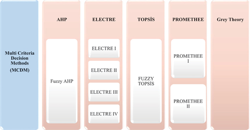
When MCDM methods are examined, it seems that more than one method is included in the literature. Each method can be effective in making site selections based on different mathematical formulas. In this study, the AHP method in MCDM methods is discussed. AHP; It enables the decision maker to apply data, experience, understanding and intuitions accurately and logically by modelling a complex problem in a hierarchical structure by showing the relationship between purpose, objectives (criteria), sub-goals and alternatives. Therefore, these advantages, the fact that it has been widely used in the literature for airport location selection, and the obtaining of meaningful results have led to the use of this method in the study.
2.1.1. Analytic Hierarchy Process (AHP)
The Analytic Hierarchy Process (AHP), one of the MCDM methods, was initially developed by Prof. Thomas L. Saaty in 1977 (Saaty Citation1980). The AHP method has been used frequently to solve complex decision-making problems. Implementation of AHP is based on three basic principles:
detecting the problem and creating a hierarchy,
creating a comparative decision-making preference matrix,
determining factor weights.
The procedure of AHP can be expressed in a series of steps:
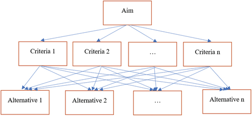
The first step for implementing the AHP is the hierarchical structuring of the decision problem. At this point, the first process is to subdivide the decision-making problem and to establish a relationship between the elements on the model. Sub-items are then categorized, edited, and created a hierarchical structure ().
Figure 3. General structure of AHP (Saaty Citation1980).
The second step of implementing the AHP is the creation of binary decision-making matrices. The binary comparison method is the basic measuring format within AHP. This method includes three stages:
creating a comparison matrix at each stage of the hierarchy,
calculating weights for each level of the hierarchy,
determining the consistency ratio.
The main purpose of creating binary comparison matrices is to determine the degree of importance within the criteria and sub-criteria. The decision-maker makes a definition based on the parameter values and definitions given in and creates the binary comparison matrix according to the significance of the parameters.
Table 1. AHP binary comparison scale (Saaty Citation1980).
(3) The weight vector is calculated after the binary comparison matrices are formed. The principle of calculating the weight vector is based on the Eigenvectors procedure (Saaty Citation1980). The elements in each column in the comparison matrix are divided by the total value of that column. Thus, the ‘Normalized Binary Comparison Matrix’ is determined, which is the sum of values equal to ‘1’ in each column and defined as Aw = [*aij] nxn.
(1)
(4) After the Aw matrix has been obtained, the arithmetic average of the elements in a row is taken. Weights are calculated according to the following equation for all i = 1, 2, … , n:
(5) The value obtained in this arithmetic mean (1 × n) forms the corresponding line of the matrix. As a result of this calculation, the n-dimensional w weight vector is obtained:
(6) Research in [41] found that there is an equality between the weight vector w and the binary comparison matrix A:
(7) The largest Eigenvalue in matrix A is λmax and this value is obtained by multiplying the elements of the binary comparison matrix with the weight vector elements. This λmax is an important part of the AHP method and a basic factor in calculating the consistency ratio (CR). At the first stage of the calculation of the CR, a consistency coefficient (CC) must be determined. The following equation can be suggested for the calculation of this coefficient:
(8) To evaluate the calculated consistency coefficient (CC) and to make a judgement as a result of the interpretations, the consistency ratio (CR) terms are defined by as follows:
(9) Within the given parameters is the random index (RI). This value is also a coincidence coefficient obtained from the binary comparison matrix ().
Table 2. Random index values (Saaty Citation1980).
Here, aij=Each column element in the comparison matrix, Aw =Normalized binary comparison matrix, W=Weight vector, λmax=Highest Eigenvalues of the matrix A, CC=Coefficient of consistency, CR= Consistency ratio, RI=Random Index.
As a result of research, an upper limit ratio was set for consistency. When the limit is less than 0.1, it can be said that the binary comparisons are acceptable. If this value is greater than 0.1, the binary comparisons contradict each other. In this case, the entire process must be repeated from the beginning. The factors determined for this study were found using the AHP method. The factor weights were tested for use in practice by the CR and the spatial analysis was performed.
2.2. Sensitivity analysis
Sensitivity analysis; It provides an examination of the effects of input data used in a model on the outputs of the model (Frey, Mokhtari, and Zheng Citation2004). Today, it is a frequently used analysis method, especially in studies based on decision-making and mostly use MCDM methods. With this analysis, while the sensitivity of the data used in the study is examined, more information about the data is obtained at the same time. The use of sensitivity analysis and MCDM methods eliminates the uncertainties that may arise, ensures data stability, and better control the data.
In studies carried out based on location, the importance of data sensitivity becomes more prominent. In recent years, in addition to MCDM methods, GIS capability has been utilized in these studies. Moreover thus, the spatial groundwork has been strengthened. (Ascough II et al. Citation2002) state that the problem is defined, researched, modelled, redefined, and thus comprehended in the decision-making studies carried out with GIS. It is a more objective approach to perform sensitivity analyses with GIS. The sensitivity of all these applications can be examined by considering location sensitivity. Thus, the sensitivities of the weights of the criteria handled can be tested by using the spatial analysis and visualization facilities of GIS (Feick and Hall Citation2004). Sensitivity analysis was carried out in the ArcGIS 10.6 program for this site selection application, which was carried out with GIS using the AHP method, one of the MCDM methods. With the analysis, the sensitivity of the criteria used in the study was examined. And then, their effects on on-site selection were examined.
2.3. Case study
2.3.1. Study area
Ordu province was determined as the study area for the airport site selection. It is located between 40°18‘and 41°08’ North latitudes and 36° 52‘and 38° 12’ East longitudes. Ordu, located in the Eastern Black Sea Region, has an area of 5861 km2. According to the data of 2020, the population of Ordu is 761,400. It is adjacent to the Black Sea in the north, Tokat and Sivas in the south, Samsun in the west and Giresun in the east. The city has 19 districts. Mesudiye district, which has the largest area, is 110 kilometres from the city centre (URL Citation2021). Black Sea climate is seen in Ordu province. Winters are warm and summers are cool. Continental climate is seen as you go down from the beach. The inner parts of the province are colder due to the increase in altitude (Citation2021). When the weather airspace factors of the General Directorate of Meteorology are examined, according to the measured values recorded between 1959–2021, the annual average temperature is 14.5; the annual average maximum temperature is 18.4; The annual average minimum temperature is 11.3 and the annual total precipitation is 1047.5 (URL Citation2023). The study area is shown in .
Figure 4. Study area.
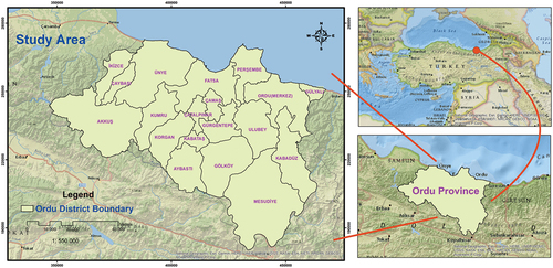
Mountains along the coast follow the coastline consisting of flat areas. The heights of these mountainous areas decrease from north to south. Melet and Turnasuyu are the two most important rivers known in Ordu, also home to many rivers. It can have few lakes and many rivers (URL Citation2021). The coastal areas of the city have a humid and temperate climate. This situation causes warm summers and cool winters. In the inner parts of the city, the continental climate is dominant. There are cooler and snowy winters here. This province, famous for its nature and greenery, has rich vegetation due to the ineffectiveness of the warm and rainy weather on the coasts.
On the other hand, having large forest areas is an important feature. It is seen that it has a road network length of 924 kilometres looking at the city’s transportation network. Air transportation is carried out because it has an airport between Ordu and Giresun (closer to Ordu). In addition, the airports in Trabzon or Samsun are also used.
2.3.2. Selection of criteria
Airports have much equipment. For this equipment to function smoothly and provide long-term service, it must be placed in the most suitable regions. In determining the settlement, the necessary restrictions for the airport should be determined, and the work should be carried out on these restrictions. The Ordu province’s environmental conditions were evaluated, and a literature review was done. As a result, essential criteria for airport site selection have been determined as five main criteria and 16 sub-criteria. The main criteria were airspace, land environment, infrastructure, terrain, and topography. The sub-criteria are wind, temperature, precipitation, noise, ecological balance, cultural diversity, proximity to power lines, proximity to communication lines, land use, land cover, airport expansion suitability, slope, elevation, proximity to roads, soil, distance to water currents.
2.3.2.1. Wind
The wind affects the performance of aircraft and runway design at the airport. They can be named differently according to the direction of the breeze. The wind breezing to the aircraft from the front is called the headwind, the wind breezing from the back is called the tailwind, and the wind breezing from the side is called the crosswind. The speed and direction of the wind are important because the take-off and landing of aircraft depending on the air’s speed. In the airport environment, it is also a factor that affects runway selection. Airplanes perform higher in take-off and landing with the wind called the headwind. Wind speed and direction also affect runway usability. Current speeds and directions may not be suitable for all aircraft. Since aircraft do not have the same wind sensitivities, these vehicles may not always be helpful, which results in a waste of money and time for operators. As another effect, it can be shown that the vehicles underway can go off course due to the wind. Strong winds may force the aircraft to change the route. Routes between airports are vital. The route change will affect the route layout (Horonjeff et al. Citation2010).
2.3.2.2. Temperatureandprecipitation
Meteorological events, which are important in airport site selection, affect the performance of aircraft and the characteristics of the runway. For example, in the summer season, when the temperature is high, an increase in the runway length required for the take-off of the aircraft is observed. That means extra cost. On the other hand, Rainfall reduces the aircraft visibility and makes flight difficult.
2.3.2.3. Noise
One environmental factor that has great importance in airport site selection is noise. Noise from the aircraft engine harms the environment. With the increasing air transportation in the developing world, aircraft development with more powerful engines has brought along the noise problem. It can also cause problems such as headaches and hearing loss. It makes communication, rest, and sleep difficult; causes restlessness, sleep disorders, and psychological problems. The reasons such as taking care of public health, which has been adopted more and more with the increasing awareness of the society over the years, also make noise an essential factor. It is also considered in the land use plan of properties located in or around the airport land area (ICAO Citation1987).
2.3.2.4. Ecological balance
Not harming the existing ecosystems in the lands considered for airport location selection is one of the issues that should be considered. Animals, plants, and vegetation are critical. The main impacts that can occur are the loss of organisms or disruption of the ecosystem. It is necessary to obtain general information about this ecological balance in the environment. For example, the airport land can be a nesting area for birds or their routes during migration. In this regard, there have been various accidents that can be shown as an example in history. Not paying attention to such situations can cause loss of life and property. As another example, there may be insects living in the field. In this context, if the spraying reaches the surface waters, there may be a danger to life for living things. The assessment techniques used for these problems include the identification of important aquatic and terrestrial organisms found in the region and determining vital support systems for the species (Stewart Citation2018).
2.3.2.5. Cultural diversity
The presence of parks, open spaces, cultural and historical sites, and archaeological excavation sites is one parameter that affects site selection. The continuity of these structures that make up the country’s history and contribute to tourism is essential. For this reason, it should be investigated whether the airport and planes cause any damage to these structures. Wrong decisions that can be made may attract public reaction and cause effects that will hinder the planning process.
2.3.2.6. Proximity to power lines and communication lines
Airports should have infrastructure facilities and every building constructed (ICAO Citation1987). Proximity to power and communication lines is important for selecting the land for airport construction. The status of this infrastructure is another important part. Since the land mentioned here covers a large area, it may be necessary to reorient existing infrastructures. The cost of this has to be calculated. The considerable distance from the infrastructure is a factor that increases the cost.
2.3.2.7. Land use and land cover
The land use around the location chosen for the airport affects the airport and the surrounding communities. In this context, let us consider one of our selection parameters, noise. The land use of the environment may not have the tolerance to absorb the noise generated from the airport. For example, for noise, an environment with industrial land use is more suitable than an environment with residential use. Considering land-use types such as bare land, industrial land, and agricultural land will avoid future adverse events during the site selection process. For instance, building an airport in a residential area may provoke reactions from the surrounding community and disrupt the planning process. This will lead to cost and time loss (Sivil Havacılık Genel Müdürlüğü Citation2012). Likewise, land cover is one of the important parameters for the land to be selected. The airport is generally preferred to be built on bare land cover.
2.3.2.8. Airport expansion suitability
Aircraft technology is a developing technology. At the same time, air transportation is a demanded type of transportation. It may be difficult for the airport to meet these developments and demands in the future. In this context, the increase in aircraft and flights may cause insufficiency in runway and aircraft parking areas. In these cases, since constructing a new airport is a long and arduous process, it is first investigated whether the existing airport can be brought to a state that can meet the expectations. Availability of suitable space on the land is sought to expand the airport components. If the land is significant, if there is no topographic defect in these areas and it does not pose any environmental problem, the land with these features takes a step forward (Sönmez Citation2017).
2.3.2.9. Slope
Another criterion to be considered in airport site selection is a slope. The slopes of the lands are expected to be 0% for airport construction. The slope is desired to below considering the aircraft. In order to achieve this, it is necessary to make the process and financial planning for the excavation or filling work to be done. The flattest one among the candidate lands is more ideal (TMMOB Jeoloji Mühendisleri Odası Citation2014).
2.3.2.10. Elevation
Another site selection parameter for the airport is elevation. This concept, referred to as airport altitude in the literature, is the elevation of the highest point of the landing site at the airport above sea level. Unfavourable situations that affect aircraft may occur at airports located at elevations too high. As aircraft go up, the air weakens, and the atmospheric pressure decreases. As a result, the aircraft has difficulty in gaining lift at take-off. Airports with this feature need longer runways in response to the low air pressure problem, and thus an increase in take-off speed is required. In addition, weak, less dense air and low atmospheric pressure make it difficult for aircraft to slow down. This may cause hazards. On the other hand, lower air density causes less friction in the aircraft, which means less fuel at higher altitudes (Horonjeff et al. Citation2010).
2.3.2.11. Proximity to roads
Another parameter in choosing a location for the airport is proximity to roads. People who choose air transportation because of fast travel quickly want to have this opportunity to reach the airport. Especially for commercial airports, this is a matter of great competition. For this reason, the selected region for the airport should be chosen close to the roads to facilitate transportation. When choosing a location for the airport, determining a location close to the city may reveal an interaction with the noise factor. For this, it is essential to set the boundaries here. The transportation to the airport is easy and similarly in a short time is also a good situation in terms of tourism. A positive impression is created for tourists who have just arrived in the country or are about to leave. As it can be understood, transportation time is one of the important parameters for the airport in terms of competition.
2.3.2.12. Soil
The properties of the land soil are essential information for construction. The higher the bearing capacity of the soil that will be the ground for the airport, the better. Studies are carried out for information such as usability, bearing capacity, groundwater depth change levels, which are called soil surveys, and enable the acquisition of physical properties of the soil. Clay soil mixed with gravel can be the most suitable soil type for the land to be selected for the construction of a new airport (Sönmez Citation2017).
2.3.2.13. Proximity to water currents
The water currents mentioned in this criterion refer to water bodies with flowing surface water. If the airport is built in such places, some changes may be observed in the water resources. Compressed and changing water resources can create security problems for the airport. For example, it can be said that the land structures of airports built on the coast have weak soil properties. This situation leads to the suppression of water currents, and as a result, ecological balance disruption and climatic changes may occur. In addition, rain waters can cause floods for regions with these features. For example, in 2012, Hatay Airport in Turkey was closed to flights due to floods in the Amik Plain (Korkmaz and Karataş Citation2012). Negative situations threaten life safety and cause financial losses for the business.
2.3.3. Data collection and GIS integration
Most of the data used in the study were obtained from the Research and Development laboratory of KTU GISLab (URL Citation2022), where the study was conducted. In addition, different institutions and sources were used for some data that could not be obtained ().
Table 3. Data layers and data sources used in the study.
The spatial data of the criteria used for the study were obtained from the relevant sources. Then, spatial data with different coordinate systems were converted into a standard coordinate system for the analysis. It is necessary to use a standard coordinate system to obtain correct results in spatial analysis. TUREF datum and UTM projection (Zone 39N) were used in this study. Then, all data were organized in the geodatabase created in the ArcGIS 10.6 program and made ready for analysis.
2.3.4. Reclassification of Criteria
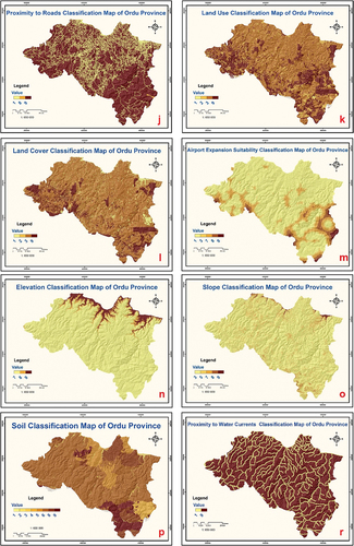
The criteria discussed in the study were determined as: the results obtained from the questionnaire study applied to a group of 30 people consisting of academicians who are experts in their fields, city planners, geomatics engineers, geology engineers, and officials working on the airport were classified using the classification intervals identified in line with the literature research. The importance values of each class were defined. Thus, the impact areas of the criteria among themselves were determined. The criteria to be used in the airport site selection are formed in hierarchical order as main criteria and sub-criteria. By performing a literature review for each criterion, the classification ranges to determine the safe zones for the airport location were determined. After all the criteria layers were converted to a raster format, the classification ranges determined were based. Then the criteria were reclassified by assigning values between 1 and 9. The classification ranges of the criteria used in the study and the classification values assigned to these ranges are shown in . In the study, 20 × 20 pixels were chosen as raster pixel size, and this value was taken into account when converting all spatial data to raster formats.
Table 4. Reclassification intervals and values of layers (Erkan and Elsharida Citation2020; Ertunç and Çay Citation2020).
The classification maps created using the classification ranges in are shown in respectively.
Figure 5. (a) Wind speed classification map, (b) Temperature classification map, (c) Precipitation classification map, (d) Noise classification map, (e) Ecological balance classification map, (f) Cultural diversity classification map, (h) Proximity to communication lines classification map, (ı) Proximity to power lines classification map, (j) Proximity to roads classification map, (k) Land use classification map, (l) Land cover classification map, (m) Airport Expansion Suitability (Proximity to buildings) classification map, (n) Elevation classification map, (o) Slope classification map, (p) Soil properties classification map, (r) Proximity to water currents classification map.
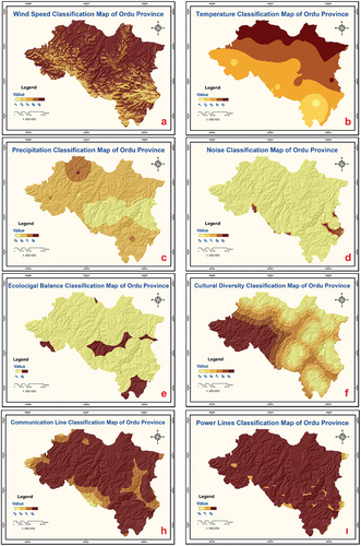
Figure 5. (Continued).
3. Results and discussion
The criteria determined for the airport site selection were prepared as layers in the ArcGIS program, reclassified, and made ready for analysis. The prepared layers were weighted according to their importance and combined in the analysis phase. AHP method, one of the Multi-Criteria Decision Making methods, was used to determine these critical levels. According to this method, the criteria weights were determined by creating pairwise comparison matrices of the criteria prepared in hierarchical order. Analyzes were carried out using the weights obtained, and as a result, the Ordu province airport site selection map was obtained. After the output map was produced, alternative points where the airport could be built were determined. Then, these alternative points were compared with each other. Finally, sensitivity analyzes were carried out in which the weights of the criteria used in the analysis were examined with different scenarios.
3.1. Determination of criterion weights with AHP method
The AHP method determines the importance level of each criterion is used for site selection, thanks to pairwise comparisons. Experts compared the criteria created in the hierarchical structure through a questionnaire study according to the 1–9 scale developed by Saaty and specified in . The obtained data were arranged and made ready for the weighting process. First, a pairwise comparison matrix was created for the main criteria. Then the matrix values are normalized and the normalized matrix is obtained. Using this matrix, the weight of each criterion was calculated. For the control of the obtained data, firstly the consistency index (CI) and with it the consistency ratio (CR) were calculated. The CR value was obtained as 0.063. The fact that this value was less than 0.10 showed that the calculations of the main criteria were consistent. The same procedures were applied for the sub-criteria. Pairwise comparison matrices were created for the sub-criteria, the matrices were normalized and the weights of the criteria were calculated. Consistency ratio (CR) was calculated for the pairwise comparison matrix of each sub-criteria, and if this ratio was below 0.10, it showed that the matrix was consistent.
Table 5. Main and sub-criteria weights obtained as a result of AHP analysis.
3.2. Airport site selection suitability map
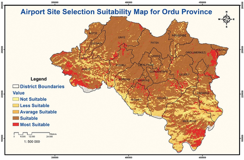
Using the criterion weights obtained by the AHP method, the classification maps were combined, and thus the airport location suitability map was produced and shown in .
Figure 6. Airport site selection suitability map for Ordu province.
3.3. Examination of the surface areas of the most suitable alternative airport location for Ordu province
Although the specific total area required for the airport’s construction has a value that varies according to the location where the construction will be made, it has been stated that an area of at least 500 hectares will be sufficient for a standard airport construction (Rodrigue Citation2020). Therefore, this information was taken into account when selecting alternative areas. According to the resulting map, the most suitable areas for airport location selection make up 7.06% of the distribution, suitable areas 72.93%, average suitable areas 4.63%, less suitable areas 14,68%, and unsuitable areas make up 0.06%. The alternative points obtained are shown in .
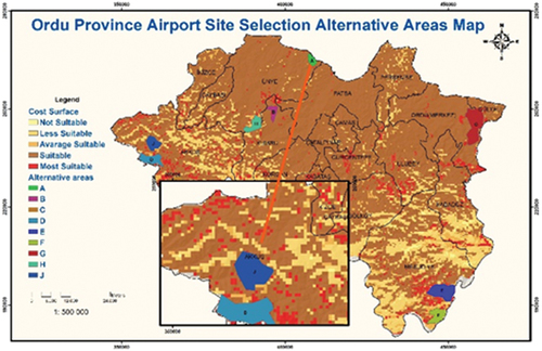
Figure 7. Surface areas of the most suitable alternative airport locations for Ordu province.
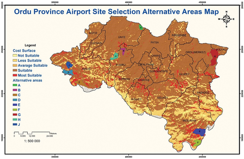
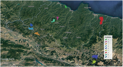
Figure 8. Suitable areas display on Google Earth.
Within the scope of the study, it is aimed to determine the most suitable places for airport site selection. In this context, the 16 criteria used to determine the most suitable place and the weights determined by the decision-makers were brought together in raster format. The resulting map showing the most suitable places was obtained. Nine regions were identified as the most suitable area (). The results were examined one by one, and the following conclusions were reached:
Area A is located in Guzelyali and Eskikizilcakese neighbourhoods of Unye district of Ordu province. It is 622 hectares. Its distance from the city centre is 51.5 km.
Area B is located in Yeniergen and Ergenturk neighbourhoods of Kumru district of Ordu province. It is 819 hectares. Its distance from the city centre is 73.4 km.
Area C is located in Cavdar village of Akkus district of Ordu province. It is 1807 hectares. Its distance from the city centre is 130 km.
Area D is near the Seferli neighbourhood of Akkus district of Ordu province. It is 1677 hectares. Its distance from the city centre is 133 km.
Area E is located in the Safe neighbourhood of Mesudiye district of Ordu province. It is 3048 hectares. The distance to the city centre is 122 km.
Area F is located in the Balikli neighbourhood of the Mesudiye district of Ordu. It is 1720 hectares. The distance to the city centre is 109 km.
Area G is located in Ordu province Altinordu district, Emenkoy, Osmaniye and Altinca neighbourhoods. It is 4229 hectares. Its distance to the city centre is 23.2 km.
Area H is located in Derekoy and Ortacokdegirmen neighbourhoods of Unye district of Ordu province. It is 1450 hectares. The distance to the city centre is 87.9 km.
Area J is located in Salman and Seferli neighbourhoods of Akkus district of Ordu province. It is 1369 hectares. The distance to the city centre is 130 km.
Figure 9. Alternative zone A.
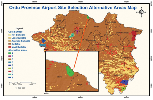
Figure 10. Alternative zone B.
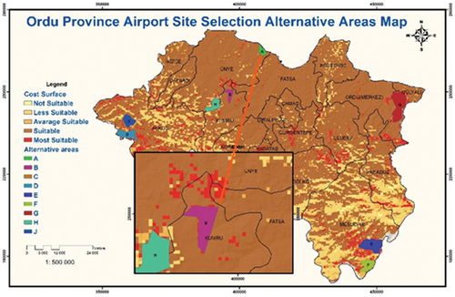
Figure 11. Alternative zone C.
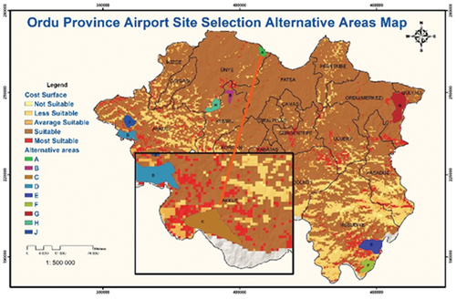
Figure 12. Alternative zone D.
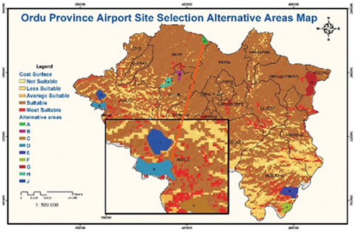
Figure 13. Alternative zone E.
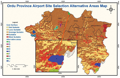
Figure 14. Alternative zone F.
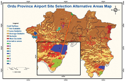
Figure 15. Alternative zone G.
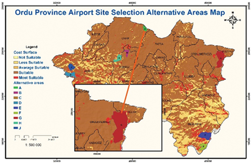
Figure 16. Alternative zone H.
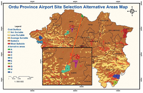
Figure 17. Alternative zone J.
3.4. Evaluation of alternative locations among each other
As a result of the application, the alternative locations preferred among the most suitable areas for airport site selection are handled by lettering. These identified locations were evaluated according to the total scores from the classification ranges, based on a scenario in which the criteria weights were assumed to be equal. This scenario is that the region with the highest value in total is accepted as the most suitable place for the scores they get according to the classification ranges of the criteria. (). Each suggested zone has sufficient width for airport construction.
Table 6. Evaluation of alternative areas.
With this scenario, the criteria scores in each alternative area were examined one by one. For example, in alternative area A, the slope criterion corresponds to 7 points, the elevation criterion corresponds to 9 points, and the temperature criterion corresponds to 9 points. All criteria were considered for each alternative area, respectively, and their scores were placed in the table. Thus, it is ensured that all alternative areas can be observed in a single table. Based on these scores, alternative areas were compared with each other.
Looking at , Alternative A has the highest score with an area of 622 hectares in the Güzelyalı Mahallesi, which is in the Ünye district of Ordu is 51.5 km away from the city centre.It is located in a different area from the currently operating Ordu-Giresun Airport. Sea filling was done for this airport. The airport was built on this fill. The airport serves both Ordu and Giresun is the closest to the provincial borders to use both cities. However, the presence of rugged and mountainous areas at the closest location of the provincial borders and the existence of urban settlements on the plains on the coast caused the lack of suitable areas for construction. As a result, the airport was built on approximately 175 hectares by filling the sea in Gülyali district (). The filling process has further increased the cost of airport construction. In addition to this cost, millions of tons of filling materials are dumped into the sea; It causes global problems such as water pollution, increases in seawater temperature, rise in sea level.
Figure 18. Ordu-Giresun Airport.
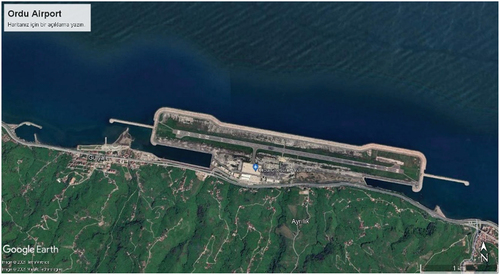
Since this study was carried out based on the land borders of Ordu Province, the most suitable place on the land was determined. The location in the Güzelyali neighbourhood was chosen as the most suitable area for the airport as a result of the study. The fact that the selected area is far from the city centre will ensure that the number of people affected by the noise and the gases released into the environment is low.
3.5. Sensitivity analysis evaluation
In the last stage of this study, a sensitivity test was applied to the raster surface map obtained from the airport site selection analysis. Each criterion used in the analysis was removed from the analysis, and the analyses were re-executed. Thus, whether the removed criterion plays an active role in the analysis of airport location selection, that is, its sensitivity in the analysis, has been tested. The analysis outputs obtained by removing each criterion in the analysis are shown in , and the evaluation results are shown in .
Figure 19. Cost surfaces recalculated raster for sensitivity analysis.
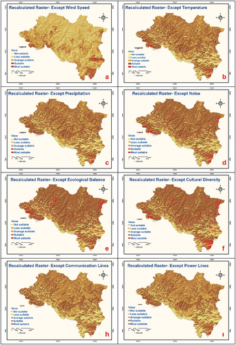
Figure 19. (Continued).
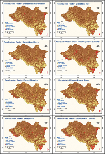
Table 7. Sensitivity analysis statistical results.
When the sensitivity analysis results for the airport site selection analysis are examined; Of the 16 criteria, 15 were found to be sensitive, and only 1 (airport expansion suitability) was found to be insensitive. In short, it has been understood that 15 criteria play an active role in airport site selection and should not be removed from the analysis during the evaluation, and removing the airport expansion suitability criterion from the analysis will not change the results to a large scale.
While 16 criteria were used in the AHP analysis process, it was concluded that 15 criteria would be sufficient for the airport location selection as a result of the sensitivity analysis. The said criteria are; “the wind speed, which is essential for the landing and take-off of aircraft, the temperature and precipitation that drive flight performance, the noise affecting the environment and legal regulations, the ecological balance that is effective in the existence of our ecosystem, the cultural diversity representing the history and touristic structure of the country, distance to power sources-communication lines and roads indicating the status of access to infrastructure facilities, land use and land cover, which play an important role in the establishment of the airport and the safety of the environment, the slope that guides the excavation-filling works for the airport construction, the elevation that ensures the balance of the air pressure required for the landing and take-off of aircraft, the main component for the ground, which is the primary structure of the airport, is the soil, distance from water currents that can cause adverse changes and safety issues for many components of airport construction and the suitability for airport expansion, which enables the construction of new structures that may be required in the future and responding to demands“.
These criteria represent both the environmental, economic, ecological and cultural aspects of the region and the basic factors necessary for the construction works. With the sensitivity analysis, the importance, accuracy and reliability of the criteria were revealed. On the other hand, it has been concluded that the criterion of suitability for airport expansion is important but not essential for site selection. When the other studies in the literature are examined, it is seen that many of these criteria are discussed, but they are shaped around the specific subject that is the basis of the study. Since this study is based on airport location selection, it has been carried out with a wider perspective. Therefore, this study serves as a guide for airport constructions and future scientific studies.
4. Conclusions
The airport location selection criteria used in the study were determined mainly by the master plan and other resources and studies. The weights of the criteria were identified based on expert opinions and previous studies. The data for the determined criteria were obtained from several different sources, primarily KTU GISLab R&D Laboratory, for the Ordu province. The analysis process was carried out on ArcGIS 10.6 software. Sixteen input layers were evaluated to select the suitable location for the airport. As a result of using the obtained weight data, nine areas were suggested as the most suitable area.
Considering that an area of 500 hectares is sufficient for airport construction when alternative areas are examined, it can be said that these areas are above the standard. In another phase of the study, an application was made to find the most suitable area among these nine candidate areas. In the scenario used in this study, all criteria weights are considered equal, and the area with the highest value in the sum of the scores they get depending on the classification intervals of the criteria is accepted as the most suitable site. As a result of this scenario, an area of 622 hectares in the Güzelyalı neighbourhood of Ordu’s Ünye district was determined as the most suitable location for airport construction. In the last stage of the study, it was mentioned that the weights of the criteria used for airport site selection should be handled in different scenarios and sensitivity analyzes were carried out in this context. The sensitivity analysis has determined that the other 15 criteria are sensitive, except for the criterion of airport expansion suitability. While removing the 15 sensitive criteria from the analysis will affect the results, excluding the insensitive criteria will not cause significant changes in the results.
In summary, as a result of this study: (1) The site selection decision for the airport, which is primarily subjective, has been made objective by basing it on a scientific form in which certain stages and various examinations are carried out. (2) Analysis with high accuracy and reliability has been made due to GIS use. (3) It has been shown that GIS, mainly used for earth sciences, can also be used in different fields of study, such as aviation. (4) The study has been gained a numerical form by obtaining the weights using the AHP method.
The site selection for the airport is work to be carried out with the team. Determining the criteria, collecting the data, making the evaluation stages by experts, getting help from experts in processing the data; will positively affect the success and reliability of the work carried out. Assistance was received from various people in this study, which was conducted for the province of Ordu. It is possible to increase or decrease the number of criteria. The cost factor in workforce and construction material resources can be added to the criteria for future studies. At the same time, groupings can be made to be different from the grouping created in this study. It is aimed that this study will guide the aviation industry and site selection studies.
Disclosure statement
The authors declare that they have no known competing financial interests or personal relationships that could have appeared to influence the work reported in this paper.
Data availability statement
The data used for this application is available on figshare. The data source is: DOI:10.6084/m9.figshare.22323316
Additional information
Funding
References
- Akça, M. 2017. “Havalimanı Yeri Uygunluğunun Değerlendirilmesi: Nitelden Nicele Bir Çalışma.” Internatıonal Journal of Economıc Studıes 3 (3): 327–334.
- Alves, C. J. P., E. J. Silva, C. Müller, G. M. R. Borille, M. X. Guterres, E. M. Arraut, M. S. Peres, and R. J. D. Santos. 2020. “Towards an Objective Decision-Making Framework for Regional Airport Site Selection.” Journal of Air Transport Management 89 (101888). doi:10.1016/j.jairtraman.2020.101888.
- Anderson, J. D. 2000. Introduction to Flight. 4 ed. New York: McGraw Hill Book Company.
- Annex14. 2006. Havaalanı Tasarımı ve İşletimi, Cilt 1. Ankara: Sivil Havacılık Genel Müdürlüğü Yayınları.
- Ascough II, J. C., H. D. Rector, D. L. Hoagh, D. L. McMaster, B. C. Vandenberg, M. J. Shaffer, Weltz, M., Ahuja, L. 2002. Multicriteria Spatial Decision Support Systems: Overview, Applications, and Future Research Directions. In Integrated Assessment and Decision Support Proceedings of the 1st Biennial Meeting of the IEMSS, June 24-27, June 24-27, 3, Lugano, Switzerland, 175–180.
- Bakırcı, M. 2012. “Ulaşım Coğrafyası Açısından Türkiye’de Havayolu Ulaşımının Tarihsel Gelişimi Ve Mevcut Yapısı.” Marmara Coğrafya Dergisi 25: 340–377.
- Ballis, A. 2003. “Airport Site Selection Based on Multicriteria Analysis: The Case Study of the Island of Samothraki.” Operational Research 3 (3): 261. doi:10.1007/BF02936405.
- Bambiger, M. S., and H. L. Vandersypen. 1969. Major Commercial Airport Location: A Methodology for the Evaluation of Potential Sites. United States: Northwestern University.
- Başer, V. 2019. “Kamu Ulaşım Yatırımlarının Taşınmaz Üzerindeki Etkileri: Ordu-Giresun Havalimanı Örneği.” Karadeniz Fen Bilimleri Dergisi 9 (1): 82–93. doi:10.31466/kfbd.541707.
- Belbağ, S., M. Deveci, and A. S. Uludağ 2013. Comparison of Two Fuzzy Multi Criteria Decision Methods for Potential Airport Location Selection. In International Conference on Operations Research and Enterprise Systems, 16-18 February, 2, Barcelona, Spain, 270–276.
- Cai, L., and X. Zhang. 1996. “Comprehensive Evaluation Intelligent Assistant Decisionmaking System of Airport Site Selection Alternative.” Aeronaut Computer Technology 3: 42–46.
- Ding, D. L., L. C. Cai, X. L. Wang, B. Shao, and Y. Zheng. 2011. “Application of Comprehensive Evaluation of the Airport Site Selection.” Applied Mechanics and Materials 97: 311–315. doi:10.4028/www.scientific.net/AMM.97-98.311.
- Doğanay, H. 2011. Türkiye Ekonomik Coğrafyası. Ankara: Pegem Akademi Yayınları.
- Erdağı, O. 1994. “Sivil Havacılıkta Taşımacılığı Düzenleyen Çok Taraflı Anlaşmalar.” Soylu Magazin 1 (4): 20.
- Erkan, T. E., and W. M. Elsharida. 2020. “Combining AHP and ROC with GIS for Airport Site Selection: A Case Study in Libya.” ISPRS International Journal of Geo-Information 9 (5): 312. doi:10.3390/ijgi9050312.
- Ertunç, E., and T. Çay. 2020. “Havaalanı Yer Seçiminde Coğrafi Bilgi Sistemleri (CBS) Ve Analitik Hiyerarşi Süreci (AHP) Kullanımı.” Konya Mühendislik Bilimleri Dergisi 8 (2): 200–210. doi:10.36306/konjes.590605.
- Feick, R., and B. Hall. 2004. “A Method for Examining the Spatial Dimension of Multicriteria Weight Sensitivity.” International Journal of Geographical Information Science 18 (8): 815–840. doi:10.1080/13658810412331280185.
- Frey, H. C., A. Mokhtari, and J. Zheng. 2004. Recommended Practice Regarding Selection, Application, and Interpretation of Sensitivity Analysis Methods Applied to Food Safety Risk Process Models. Washington, DC: US Department of Agriculture.
- Fu, Q., N. Wang, M. Shen, N. Song, and H. Yan. 2016. “A Study of the Site Selection of a Civil Airport Based on the Risk of Bird Strikes: The Case of Dalian, China.” Journal of Air Transport Management 54: 17–30. doi:10.1016/j.jairtraman.2016.03.016.
- Graham, A. 2008. Managing Airports, an International Perspective. Third edit ed. United Kingdom: Butterworth- Heinemann.
- Han, B., T. Qu, Z. Huang, Q. Wang, and Z. Pan. 2022. “Emergency Airport Site Selection Using Global Subdivision Grids.” Big Earth Data 6 (3): 276–293. doi:10.1080/20964471.2021.1996866.
- Horonjeff, R., F. X. McKelvey, W. J. Sproule, and S. B. Young. 2010. Planning and Design of Airports. 5th editio ed. New York, ABD: The McGraw-Hill Companies.
- Huang, B., J. Lin, X. Zheng, and X. Fang. 2013. “Airport Site Selection Under Complex Airspace Based on GIS.“ In ICTE 2013: Safety, Speediness, Intelligence, Low-Carbon, Innovation, edited byQ. Peng, K.C.P. Wang, 2188–2194. Chengdu, China: ASCE.
- ICAO. 1987. Airport Planning Manual. Second Edi ed. Montreal, Kanada: International Civil Aviation Organization.
- Karabıçak, Ç., A. İ. Boyacı, M. Kocabaş Akay, and B. Özcan. 2016. “Çok Kriterli Karar Verme Yöntemleri Ve Karayolu Şantiye Yeri Seçimine İlişkin Bir Uygulama.” Kastamonu Üniversitesi İktisadi Ve İdari Bilimler Fakültesi Dergisi 13: 109–114.
- Kassomenos, P. A., I. K. Panagopoulos, and A. Karagiannis. 2005. “An Integrated Methodology to Select the Optimum Site of an Airport on an Island Using Limited Meteorological Information.” Meteorological Applications 12 (3): 231–240. doi:10.1017/S1350482705001702.
- Kıanısadr, M. 2019. “Airport Site Selection of Tehran, Iran.” Iranian Journal of Public Health 48 (6): 1187–1188. doi:10.18502/ijph.v48i6.2939.
- Korkmaz, H., and A. Karataş. 2012. “Ocak-Mart 2012 Hatay Havaalanı Taşkını.“ In III. Ulusal Jeomorfoloji Sempozyumu, edited by H. Korkmaz, A. Karataş, 478–494. Hatay: Color Ofset.
- Liao, Y., and F. Bao. 2014. “Research on Airport Site Selection Based on Triangular Fuzzy Number.” Applied Mechanics and Materials 505: 507–511. doi:10.4028/www.scientific.net/AMM.505-506.507.
- Martel, J. M., and B. Aouni. 1992. “Multicriteria Method for Site Selection-Example of an Airport for New Quebec.” INFOR 30 (2): 97–117. doi:10.1080/03155986.1992.11732187.
- Min, H. 1994. “Location Planning of Airport Facilities Using the Analytic Hierarchy Process.” The Logistics and Transportation Review 30 (1): 79.
- Min, H., E. Melachrinoudis, and X. Wu. 1997. “Dynamic Expansion and Location of an Airport: A Multiple Objective Approach.” Transportation Research Part A: Policy and Practice 31 (5): 403–417. doi:10.1016/S0965-8564(96)00037-7.
- Oktal, H. 1998. Coğrafi Bilgi Sistemleri Yardımı ile Havaalanı Yer Seçimi Model Önerisi. Eskişehir: Anadolu Üniversitesi, Fen Bilimleri Enstitüsü. Doktora Tezi.
- Oyman, K. 1998. Havaalanları Yönetim Modeli ve lşleyiş Sistemleri. Eskişehir: Anadolu Üniversitesi, Sosyal Bilimler Enstitüsü.
- Özdağoğlu, A., M. K. Keleş, and B. Işıldak. 2021. “Dünyanın En İşlek Havalimanlarının Pıprecıa-E, Smart Ve Marcos Yöntemleri İle Değerlendirilmesi.” Erciyes Üniversitesi İktisadi ve İdari Bilimler Fakültesi Dergisi 58: 333–352.
- Özür, N. 2018. “Türkiye’de havalimanlarının kuruluş yerlerinin sürdürülebilir arazi kullanımı bakımından değerlendirilmesi.” Türk Coğrafya Dergisi 71: 15–25. doi:10.17211/tcd.413346.
- Paelinck, J. 1977. “Qualitative Multicriteria Analysis: An Application to Airport Location.” Environment and Planning A: Economy and Space 9 (8): 883–895. doi:10.1068/a090883.
- Palczewski, K., and W. Sałabun. 2019. “Influence of Various Normalization Methods in PROMETHEE II: An Empirical Study on the Selection of the Airport Location.” Procedia computer science 159: 2051–2060. doi:10.1016/j.procs.2019.09.378.
- Rodrigue, J. P. 2020. The Geography of Transport Systems. New York: Taylor & Francis Ltd.
- Saaty, T. L. 1980. The Analytic Hierarchy Process. New York: McGraw-Hill.
- Saaty, T. L. 1989. “Hierarchical-Multiobjective System.” Control-Theory and Advanced Technology 5 (4): 485–489.
- Sennaroglu, B., and G. Varlik Celebi. 2018. “A Military Airport Location Selection by AHP Integrated PROMETHEE and VIKOR Methods.” Transportation Research Part D 59: 160–173. doi:10.1016/j.trd.2017.12.022.
- Sivil Havacılık Genel Müdürlüğü. 2012. Arazi Kullanımı ve Çevre Kontrolü. Ankara: Pegem Akademi Yayıncılık.
- Sönmez, İ. 2017. Havalimanı Yönetimi. İstanbul: İstanbul Üniversitesi Açık ve Uzaktan Eğitim Fakültesi.
- Stewart, D. 2018. “Airport Master Planning-Process & Update.“ In ICAO Airport Planning Seminar for the SAM Region, edited byD. Stewart, 35. Lima, Peru: ICAO.
- TMMOB Jeoloji Mühendisleri Odası. 2014. Çevre Jeolojisi Açısından 3. Havaalanı. Türkiye: İstanbul.
- Togatlian, M., A. Correia, and M. Belderrain. 2006. “A Modeling Tool to Assist on the Decision Process of Determining the Optimal Location of an Industrial Airport in Brazil.” Journal of the Brazilian Air Transportation Research Society 3: 81–99.
- Tümertekin, E. 1987. Ulaşım Coğrafyası. İstanbul: Türkiyat Matbaacılık.
- Türk, H. 2015. Ordu Giresun Havalimanı (Mekan Seçimi ve Muhtemel Etkileri). Giresun: Giresun Üniversitesi.
- URL-1. 2021. Ordu Halk Kültürü. Karadeniz Kültür Envanteri. https://karadeniz.gov.tr/fiziki-ve-tarihi-cevre-5/.
- URL-2. 2022. https://ktu.edu.tr/gislab.
- URL-3. 2023. T.C. Çevre, Şehircilik ve İklim Değişikliği Bakanlığı, Meteoroloji Genel Müdürlüğü. https://www.mgm.gov.tr/veridegerlendirme/il-ve-ilceler-istatistik.aspx?=ORDU.
- Van Der Kleij, C. S., S. J. M. H. Hulscher, and T. Louters. 2003. “Comparing Uncertain Alternatives for a Possible Airport Island Location in the North Sea.” Ocean & Coastal Management 46 (11–12): 1031–1047. doi:10.1016/j.ocecoaman.2003.09.001.
- Wang, Z., L. Cai, X. Chong, and L. Zhang 2009. Airport Site Selection Based on Uncertain Multi-Attribute Decision Making in Logistics. In Eighth International Conference of Chinese Logistics and Transportation Professionals (pp. 647–654). China.
- Yang, C. Q., T. Wu, and Y. Liao. 2014. “Evaluation for the Location Selection of Airport Based on WLSM-TOPSIS Method.” Applied Mechanics and Materials 548: 1823–1827. doi:10.4028/www.scientific.net/AMM.548-549.1823.
- Zhao, S., and P. Sun. 2013. “Scheme Comparison of New Airport Site Selection Based on Lattice Order Decision Making Method in the Integrated Transportation System.” International Journal of Online and Biomedical Engineering 9 (4): 95–99. doi:10.3991/ijoe.v9iS4.2712.
- Zhao, B., N. Wang, Q. Fu, H. -K. Yan, and N. Wu. 2019. “Searching a Site for a Civil Airport Based on Bird Ecological Conservation: An Expert-Based Selection (Dalian, China).” Global Ecology and Conservation 20: 20. doi:https://doi.org/10.1016/j.gecco.2019.e00729.