
 ?Mathematical formulae have been encoded as MathML and are displayed in this HTML version using MathJax in order to improve their display. Uncheck the box to turn MathJax off. This feature requires Javascript. Click on a formula to zoom.
ABSTRACT
Quantitative geographical methods have played an important role in COVID-19 research. To complement and extend previous review studies, we conduct a scoping review of COVID-19 studies employing quantitative geographical approaches by focusing on 331 papers published in 45 journals in geography, urban studies, and planning. We identify four major research themes (clusters): (1) how SARS-CoV-2 viruses spread in cities, (2) the COVID-19 mortality (death) rates and their association with socioeconomic variables, (3) how the COVID-19 pandemic changed people’s mobilities, and (4) how the COVID-19 pandemic affects air pollution. We conclude that spatial models play a key role in COVID-19 quantitative geographical approaches, and human mobility is an important and widely studied topic. We also reveal a lack of research focusing on environmental pollution (other than air pollution) that potentially worsened during the pandemic.
1. Introduction
Since December 2019, the COVID-19 pandemic has been a major global public health concern. Researchers from diverse disciplines have been tirelessly developing ways to mitigate the social, environmental, and economic impacts of the pandemic. Quantitative geographical methods have played an important role in COVID-19 research (Boulos and Geraghty Citation2020; Kim and Kwan Citation2021a; Smith and Mennis Citation2020; Yang et al. Citation2020). Utilizing numeric data with locational properties, these methods include spatial and spatiotemporal modelling, visualization, optimization, simulation, and other statistical methods (McLafferty Citation2020; McLafferty, Guhlincozzi, and Winata Citation2021; Murray Citation2010).
For instance, COVID-19 dashboards have proved effective in sharing pandemic-specific geospatial information (i.e. maps, statistics on confirmed case and death rates, and charts) with citizens (e.g. Dong, Du, and Gardner Citation2020; Kolak et al. Citation2021; Kumar et al. Citation2021). COVID-19 pandemic spatial and spatiotemporal models have been actively developed by researchers (e.g. Cuadros et al. Citation2020; Liu and Li Citation2021; Nasiri et al. Citation2021; Oyedotun and Moonsammy Citation2021; Rohleder and Bozorgmehr Citation2021). These models focus on how the SARS-CoV-2 virus spreads and ultimately predict the severity of the pandemic based on metrics such as daily confirmed cases and death rates. These models are particularly helpful in developing evidence-based pandemic policies (e.g. lockdown and quarantine) that aim to mitigate the pandemic’s impacts.
Previous studies have reviewed the role of quantitative geographical approaches in COVID-19 research. For example, Franch-Pardo et al. (Citation2020) reviewed 63 studies that were conducted in the very early stage of the pandemic (January – April 2020). Their review highlights the importance of geospatial data and GIScience methods in COVID-19 research and illustrates five research areas: spatiotemporal analysis, health and social geography, environmental variables, data mining, and web-based mapping. Franch‐Pardo et al. (Citation2021) extended their earlier review by focusing on papers published in the second half of 2020 and yielded similar findings. Similarly, Fatima et al. (Citation2021) identified four quantitative geographical methods by reviewing 38 papers published before September 2020. They found that clustering, hotspot analysis, space-time scan statistics, and regression modelling were utilized frequently. McLafferty et al. (Citation2021) discussed quantitative geographical approaches in COVID-19 research from critical perspectives. They recommended that researchers and policymakers be cautious about uncertainties and biases in COVID-19 data.
To complement and extend previous review studies, we conduct a scoping review of COVID-19 studies employing quantitative geographical approaches. Specifically, our study aims to (i) include more recently published papers and (ii) identify major research themes. First, our scoping review expands the study timeline by including papers published in 2021 to provide a more comprehensive review. Extending the study timeline of the scoping review is important because of the continuing nature of the COVID-19 pandemic, with many COVID-19 research papers forthcoming that previous reviews have not covered.
Second, we identify major research themes to enhance our understanding of the role of quantitative geographical approaches in COVID-19 research. Since the pandemic has impacted almost all aspects of our lives, including social, environmental, and economic aspects, examining the pandemic’s impacts has been an important research topic for geographers (Laituri et al. Citation2021). This examination reveals gaps and under-studied areas of the pandemic. By implementing a text mining method, we identify major research themes from a much larger collection of COVID-19 papers adopting quantitative geographical approaches.
2. Data and methods
2.1. Data
We focused on 331 COVID-19 research papers that adopt quantitative geographical approaches in 45 peer-reviewed academic journals, specifically in the fields of geography, urban studies, and planning (). We created a list of these journals by referring to multiple sources, including a research article (e.g. Franklin et al. Citation2021) and the Scimago Journal Rank (SJR)’s ‘Geography, Planning, and Development’ and ‘Urban Studies’ categories (SJR Citation2021). As there is no singular list of journals that adopt quantitative geographical approaches, we assessed whether each journal was suitable for our research purpose based on the journal’s aim and scope statements. These 45 journals can represent the general research trends in geography, urban studies, and planning.Footnote1
Table 1. 45 peer-reviewed academic journals (331 papers) that typically publish papers adopting quantitative geographical approaches. The number of selected papers published in each journal is in parentheses.
We manually searched each journal for COVID-19 papers adopting quantitative geographical approaches by using keywords such as COVID and COVID-19. From our search query, we checked if the paper was an empirical study (i.e. we excluded review and commentary papers) and utilized quantitative geographical methods by referring to its data and method sections. We defined quantitative geographical methods broadly by including a wide spectrum of quantitative methods, such as spatial and spatiotemporal modelling and visualization, optimization, simulation, and other statistical methods (McLafferty Citation2020; McLafferty, Guhlincozzi, and Winata Citation2021; Murray Citation2010). Three of the authors cross-validated the selection results to minimize errors. The search was conducted in late October 2021, indicating that our analysis is based on papers published between January 2020 and October 2021.
2.2. Methods: clustering abstracts of COVID-19 research papers adopting quantitative geographical approaches
To identify major research themes of COVID-19 studies adopting quantitative geographical approaches, we utilized the text mining method (Bafna, Pramod, and Vaidya Citation2016; Green et al. Citation2020), which is one of the machine learning methods (). This method yields several clusters to which papers that share a similar research theme are assigned. We used each paper’s abstract for the text mining. We did not consider papers’ titles and keywords because abstracts typically reflect important information obtained from the title and keywords.
Figure 1. Overview of our research method (text mining).
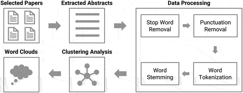
The first step is data processing, which includes addressing stop words, stemming words, and calculating a term frequency-inverse document frequency (-
) matrix. We removed stop words (e.g. ‘a’, ‘the’, ‘of’, ‘this’) that are less meaningful for clustering papers from the abstracts of the papers in our database. Note that the stop words also included several variations of the word ‘COVID-19’ (e.g. ‘COVID’, ‘COVID-19’, ‘Corona’). Removing stop words from abstracts allows clustering to be done based on more meaningful information from each abstract, which is important to increase the quality of text mining. After removing stop words from the abstract of each paper, we stemmed each word to change it to the root form (e.g. removing ‘−s’, ‘−ed’, ‘−ing’).
In the next step, we calculated a -
matrix. This matrix has 331 rows (i.e. 331 abstracts in our database) and 3,871 columns. The number of columns indicates the number of unique stemmed words (not including stop words) in the abstracts of all 331 papers. Each entity in the matrix indicates a
-
value of a word
in an abstract
(EquationEquation 1
(1)
(1) ).
where indicates the term frequency of a word
in an abstract
,
denotes the number of abstracts in our database (i.e. 331), and
denotes the number of abstracts that contain a word
. For clustering papers, using
-
is better than using simple word frequency because
-
considers the unique contribution of each word to the entire abstract, which leads to a better quality of clustering (Bafna, Pramod, and Vaidya Citation2016). Words that appeared more times in a paper tend to have a higher
-
index value than words appeared less times in the paper. However, words appeared in more papers tend to have a lower index value than words appeared in fewer papers.
The third step is clustering papers by using the -
matrix created in the second step (Bafna, Pramod, and Vaidya Citation2016; Kim and Gil Citation2019; Singh, Tiwari, and Garg Citation2011). We selected the K-means++ clustering algorithm (a variation of the K-means clustering algorithm) because we can control seed values, allowing us to have consistent clustering results. We used the default setting of the K-means++ clustering algorithm in Python’s scikit-learn library (Pedregosa et al. Citation2011). We used Euclidean distance to calculate the similarity score between two abstracts by referring to the
-
matrix. To select the number of clusters (
), we observed three clustering performance evaluation metrics: the elbow method, the Davies-Bouldin score (DBS score), and the silhouette score (Han, Pei, and Kamber Citation2011). Regarding the elbow method and the DBS score, the number of clusters is determined when the score’s drop rate becomes lower. For the silhouette score, a higher score indicates a better cluster quality. Additionally, we qualitatively observed the clustering results to see if they provided meaningful and significant interpretations. As a result, each abstract was assigned to one of the
clusters. For abstracts assigned to each cluster, we also summarized the number of abstracts in terms of the papers’ study area (geographic region). By developing an ad-hoc Python programme utilizing several packages (e.g. Bird, Klein, and Loper Citation2009), we also created word clouds that visualize important words that compose each cluster. These word clouds are particularly useful for identifying and visualizing a research theme of each cluster.
3. Results
We first present the results of clustering evaluation metrics to decide the number of clusters. illustrates the results of the clustering evaluation metrics. is based on the elbow method, is based on the DBS score, and is based on the silhouette score. (Refer to Section 2.2 regarding how these scores were used for determining the cluster numbers.) Overall, the clustering evaluation metrics indicate that possible cluster numbers are four (2[b]), six (2[b] and 2[c]), and seven (2[a], 2[b], and 2[c]). It is worth mentioning that both quantitative (i.e. metric-based) and qualitative (i.e. interpretation by researchers) evaluations are used when determining the number of clusters (e.g. Han, Pei, and Kamber Citation2011; Witten, Frank, and Hall Citation2011).
Figure 2. Clustering evaluation metric results based on the (a) elbow method, (b) DBS score, and (c) silhouette score. (Note: Regarding the elbow method and the DBS score, the number of clusters is determined when the score’s drop rate becomes lower. For the silhouette score, a higher score indicates a better cluster quality. Additionally, we qualitatively observed the clustering results to see if they provided meaningful interpretations.).
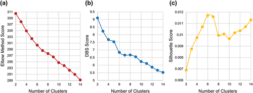
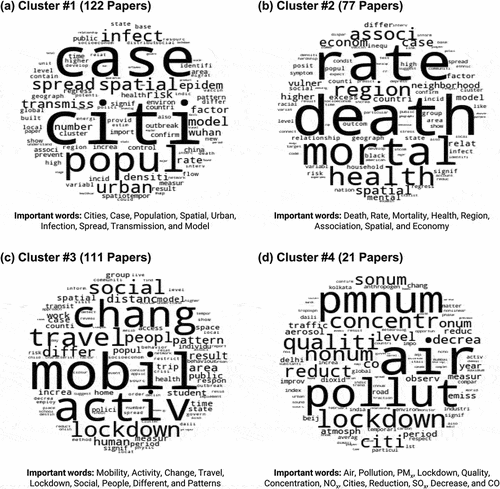
We decided on four clusters because the primary clustering results of six and seven clusters did not provide interpretable and significant research themes for their clusters. In other words, since four clusters provide the clearest interpretable results, we decided to base our analysis using four clusters: Cluster #1 (122 papers, 36.9%), Cluster #2 (77 papers, 23.3%), Cluster #3 (111 papers, 33.5%), and Cluster #4 (21 papers, 6.6%). illustrates a word cloud for each cluster. The following subsections discuss each cluster in detail and identify the major research themes of each cluster.
Figure 3. Word cloud result of (a) cluster #1 (papers that investigated how SARS-CoV-2 viruses spread in cities by using spatial models), (b) cluster #2 (papers that investigated the COVID-19 mortality rates and their association with socioeconomic variables by using spatial models), (c) cluster #3 (papers that investigated how people’s mobilities (activity-travel patterns) have been changed by the COVID-19 pandemic), and (d) cluster #4 (papers that investigated how the COVID-19 pandemic affects air pollution).
3.1. Cluster #1: papers that investigated how SARS-CoV-2 viruses spread in cities by using spatial models
Cluster #1 consists of 122 papers (36.9% of 331 papers total). illustrates a word cloud representing the important words that compose this cluster, where the larger size of a word indicates a more important word that uniquely contributes to the cluster. The word cloud illustrates these important words: Cities, Case, Population, Spatial, Urban, Infection, Spread, Transmission, and Model.
We identified the major research theme of Cluster #1 as Papers that investigated how SARS-CoV-2 viruses spread in cities by using spatial models. Since the beginning of the COVID-19 pandemic, we have witnessed that various spatial models – such as hot spot analysis (e.g. Das et al. Citation2021; Huang Citation2021; Kuznetsov and Sadovskaya Citation2021; Purwanto et al. Citation2021), space-time scan statistics and clustering (e.g. Desjardins, Hohl, and Delmelle Citation2020; Hohl et al. Citation2020; Liu et al. Citation2021; Pribadi et al. Citation2021; Wang et al. Citation2020; Zheng, Wang, and Li Citation2021) – play an important role in modelling the transmission of viruses in order to better understand the pandemic. Moreover, researchers have paid special attention to cities and urban areas (e.g. Ghosh et al. Citation2020; Gupta, Biswas, and Kabiraj Citation2021; Huang et al. Citation2022; Kawlra and Sakamoto Citation2021; Liu Citation2020; Panda and Ray Citation2021), which are major epicentres of the COVID-19 pandemic. In Cluster #1, China (40 papers, 33.3%) and the U.S. (18 papers, 15.0%) are the most-studied geographic areas of these papers, accounting for approximately 50% of the papers in the cluster.
3.2. Cluster #2: papers that investigated the COVID-19 mortality rates and their association with socioeconomic variables by using spatial models
Cluster #2 consists of 77 papers (23.3% of 331 papers total). The word cloud () highlights several important words: Death, Rate, Mortality, Health, Region, Association, Spatial, and Economy. We identified one major and one sub-theme.
The major research theme of this cluster (57 of 77 papers, 74.0%) is: Papers that investigated the COVID-19 mortality rates and their association with socioeconomic variables by using spatial models. We also observe several common words (e.g. ‘Spatial’, ‘Case’, ‘Rate’) that appear in both Clusters #1 and #2, indicating that the major research theme of Cluster #2 is similar to that of Cluster #1. However, papers in Cluster #2 particularly focus on mortality (death) rates as a variable to be investigated, which is different from confirmed cases. The regional pattern of COVID-19 death rates and how these death rates are associated with social and economic conditions are essential research themes in COVID-19 studies that adopt quantitative geographical approaches (e.g. Cassan and Van Steenvoort Citation2021; Friedman and Lee Citation2021; Grekousis, Wang, and Liu Citation2021; Hamidi, Ewing, and Sabouri Citation2020; Harris Citation2020; Kim et al. Citation2021; Riley et al. Citation2021; Vanthomme et al. Citation2021; Yang, Kim, and Matthews Citation2021). This is because these studies’ results can provide important insights into existing socio-spatial disparities in health policy and infrastructure that may lead to disparities in COVID-19 death rates.
We also identified one sub-theme within this cluster (20 papers). These papers investigate the impacts of the COVID-19 pandemic on people’s health outcomes, particularly focusing on mental health and well-being (e.g. Alnasrallah and Alshehab Citation2020; Chen, Zou, and Gao Citation2021; Finucane et al. Citation2022; Long et al. Citation2021; Vloo et al. Citation2021; Yang and Xiang Citation2021). In Cluster #2, papers focusing on the U.S. are the most common (32 papers, 42.1%), followed by papers focusing on multiple countries that often include middle- and high-income group countries (15 papers, 19.7%). One interesting observation is that there is a lower percentage of papers focusing on China in Cluster #2 (2.6%) than in Cluster #1 (3.3%).
3.3. Cluster #3: papers that investigated how people’s mobilities (activity-travel patterns) have been changed by the COVID-19 pandemic
There are 111 papers in the third cluster (33.5% of 331 papers total). We identified one major and two sub-themes (). The word cloud’s important words are: Mobility, Activity, Change, Travel, Lockdown, Social, People, Different, and Patterns.
The major research theme of this cluster (50 of 111 papers, 45%) is: Papers that investigated how people’s mobilities (activity-travel patterns) have been changed by the COVID-19 pandemic. Understanding people’s mobility is one of the key research themes in studies adopting quantitative geographical approaches (Kwan and Schwanen Citation2016), and this is also the case for COVID-19 research. By utilizing human mobility and activity-travel data, researchers have investigated how the COVID-19 pandemic (especially lockdown policies) affects people’s mobility or activity-travel patterns (e.g. Huang et al. Citation2022; Kar, Le, and Miller Citation2021; Long and Ren Citation2022; McKenzie and Adams Citation2020; Trasberg and Cheshire Citation2021).
We also identified two sub-themes within this cluster. The first sub-theme (33 of 111 papers, 29.8%) is the impact of human mobility on the COVID-19 pandemic, such as virus transmission, new cases, and mortality rates (e.g. Abulibdeh and Mansour Citation2022; Chiba Citation2021; Guo et al. Citation2021; Kosfeld et al. Citation2021; Manout and Ciari Citation2021; Praharaj and Han Citation2022). The second sub-theme (28 of 111 papers, 25.2%) includes research on other human mobility topics, such as the pandemic’s impacts on people’s physical activities (e.g. Mitra et al. Citation2020; Nigg et al. Citation2021; Portegijs et al. Citation2021; Sadeghipour et al. Citation2021; Shaer et al. Citation2021).
Regarding the study area, the U.S. is the most studied area (29 papers, 26.6%), followed by multi-country regions (7 papers, 6.4%), China (7 papers, 6.4%), Japan (6 papers, 5.5%), Spain (6 papers, 5.5%), and the U.K. (6 papers, 5.5%). These six study areas account for approximately 56% of the papers in this cluster.
3.4. Cluster #4: papers that investigated how the COVID-19 pandemic affects air pollution
Cluster #4 consists of 21 papers (6.6% of 331 papers total). We identified one major research theme by observing the word cloud () and the papers assigned to this cluster. The word cloud illustrates several important words: Air, Pollution, PMx, Lockdown, Quality, Concentration, NOx, Cities, Reduction, SOx, Decrease, and CO. Many papers in this cluster investigated the impacts of the pandemic on air pollution concentration levels – such as PMx, NOx, SOx, and CO – in cities (e.g. Basu et al. Citation2021; Han, Zhao, and Gu Citation2021; He, Pan, and Tanaka Citation2020; Polednik Citation2021; Tang et al. Citation2021; Tao et al. Citation2021; Xin et al. Citation2021). Regarding the study area, the highest number of studies (8 papers, 38.1%) focused on multiple countries (e.g. Bar et al. Citation2021; Benchrif et al. Citation2021; Sharma and Verma Citation2021; Wang and Li Citation2021), followed by 6 papers (28.6%) focused on India (e.g. Behera et al. Citation2021; Kumar et al. Citation2020; Roy and Balling Citation2021; Sathe et al. Citation2021). Compared to the previous three clusters, this is an interesting observation that may imply that air pollution is one of the most important environmental issues in India.
4. Discussion
4.1. Discussion on clustering results
To understand the role of quantitative geographical approaches in COVID-19 research, we applied a text mining method to 331 papers’ abstracts and identified four clusters related to major research themes. We discovered a number of important findings by observing these clustering results.
First, spatial methods and models (e.g. hot spot analysis, space-time scan statistics, and spatial clustering) play a key role in COVID-19 quantitative geographical approaches, which aligns with findings from previous reviews (e.g. Fatima et al. Citation2021; Franch-Pardo et al. Citation2020; Franch‐Pardo et al. Citation2021). Clusters #1 and #2 account for approximately 60% of the 331 papers, and many papers in these two clusters utilize various spatial models. For instance, hot spot analysis was employed to detect hot spots of new COVID-19 cases (e.g. Das et al. Citation2021; Huang et al. Citation2021). The space-time scan statistics method was utilized to detect statistically significant COVID-19 spatio-temporal clusters (e.g. Desjardins, Hohl, and Delmelle Citation2020; Hohl et al. Citation2020). Overall, these quantitative geographical methods are crucial for producing geographic knowledge pertaining to understanding the pandemic and formulating public health policies (e.g. identifying where to prioritize in providing public resources to mitigate the negative impacts of the pandemic).
Second, in terms of research topics, human mobility is an important and widely studied topic in COVID-19 research (Cluster #3), which aligns with our general expectations. Understanding human mobility has been one of the core research themes in studies adopting quantitative geographical approaches (Kwan and Schwanen Citation2016). Thus, it is reasonable to observe many studies on human mobilities.
Additionally, it is interesting to observe more studies focusing on air pollution rather than other environmental pollutants (Cluster #4). Considering the wide spectrum of potential environmental impacts (e.g. water, waste, etc.) of the COVID-19 pandemic (e.g. Benson, Bassey, and Palanisami Citation2021; Burlea-Schiopoiu et al. Citation2021; Elsaid et al. Citation2021; Haghnazar et al. Citation2022; Lokhandwala and Gautam Citation2020; Peng et al. Citation2021; Sarkodie and Owusu Citation2021; Yunus, Masago, and Hijioka Citation2020), our results revealed a lack of research effort on environmental pollutions that potentially have been worsened by the pandemic, such as solid medical wastes, including large quantities of disposed face masks (Sangkham Citation2020).
Moreover, we found that data availability plays an important role in shaping research theme clusters. For example, many researchers were able to conduct studies on the spatial modelling of COVID-19 cases (Cluster #1) and death rates (Cluster #2) because data were available from public health authorities such as the World Health Organization (WHO) and the U.S. Centers for Disease Control and Prevention (CDC). Also, many public data dashboards – such as Our World in Data, The New York Times, and Johns Hopkins University COVID-19 Dashboard – provided detailed COVID-19 data (e.g. daily confirmed cases and death rates). By utilizing publicly available COVID-19 data, researchers were able to establish spatial models to understand the COVID-19 pandemic, which led to many research papers (i.e. Clusters #1 and #2).
Cluster #3 adds another piece of evidence in support of the importance of data availability. During the COVID-19 pandemic, various mobility datasets have been made available to researchers, such as Google Mobility Report and Apple Mobility Report (e.g. Hamidi and Zandiatashbar Citation2021; Marcén and Morales Citation2021; Oliveira et al. Citation2021; Saha, Mondal, and Chouhan Citation2021). These mobility datasets are derived from millions of users’ mobile phone signal locations. Other mobility datasets include smart card data, cell phone location signal data, and geo-tagged SNS data (e.g. Bhin and Son Citation2021; Caicedo, Walker, and González Citation2021; Eom, Jang, and Ji Citation2022; Jiang, Huang, and Li Citation2021). Due to recent advances in high-performance computing resources, large mobility datasets can be processed quickly. This has resulted in many COVID-19 studies on human mobility (i.e. Cluster #3). Cluster #4 also provides evidence of the importance of data availability. We illustrated that air pollution gained more attention than other environmental pollutants (e.g. water and waste). One possible explanation is that air pollution datasets are more readily available than other environmental pollutants. Global air pollution datasets, which are high resolution spatially and temporally, are easily available to researchers due to recent advances in remote sensing. However, this is not the case for other environmental pollutants whose datasets are relatively difficult to obtain.
4.2. Future research directions
Based on the clustering results, we identify five potential future directions for COVID-19 research adopting quantitative geographical approaches.
First, although many studies have already focused on spatial modelling (e.g. Clusters #1 and #2), we recommend that researchers keep focusing on this topic because of the persisting situation of the COVID-19 pandemic at the time of writing. The COVID-19 pandemic has had several phases regarding new confirmed cases and death rates, and these phases differ geographically. Moreover, people’s behavioural reactions to the pandemic have changed over time, such as quarantine fatigue and change in people’s COVID-19 risk perceptions (e.g. Kim and Kwan Citation2021b; Wise et al. Citation2020). Therefore, more comprehensive research on the COVID-19 pandemic through spatial modelling is still needed to enhance our understanding of the pandemic.
However, as Helbich et al. (Citation2021) argued, COVID-19 research on spatial modelling needs to address spatiotemporal uncertainties and scale issues to mitigate potential methodological issues. These include the modifiable areal unit problem (MAUP; Openshaw Citation1984), the modifiable temporal unit problem (MTUP; Cheng, Adepeju, and Preis Citation2014), the uncertain geographic context problem (UGCoP; Kwan Citation2012), and the neighbourhood effect averaging problem (NEAP; Kwan Citation2018), which have been extensively studied in the context of quantitative geographical approaches but not necessarily in the COVID-19 research (e.g. Huang and Kwan Citation2022). This is one of the important future research directions in quantitative geographical approaches, which will eventually improve models to promote public health emergency preparedness and response.
Second, we recommend that researchers focus on emerging topics such as disparities in vaccination site accessibility and vaccination rates. Although vaccination is one of the most important topics related to the COVID-19 pandemic, our clustering analysis results at the time of writing revealed that it was less studied, with some exceptions (e.g. Alemdar et al. Citation2021; Yang, Kim, and Matthews Citation2021; Nino, Hearne, and Cai Citation2021). Some studies have investigated the important role of telehealth that helps healthcare accessibility (e.g. COVID-19 vaccination clinics) during the pandemic (e.g. Alford-Teaster et al. Citation2021; Yang, Kim, and Matthews Citation2021). One possible explanation is that our analysis was based on papers published before October 2021, when fewer people were vaccinated. Thus, we recommend that future researchers investigate important topics related to vaccination, such as disparities in vaccination site accessibility, geographic patterns of vaccine hesitancy, and so on.
Third, regarding Cluster #3, we recommend that researchers focus on other aspects of human mobility in COVID-19 research. As we discussed, many previous studies utilized mobility data obtained from mobile phone signal locations while focusing on travel distance as a key human mobility variable. Due to the nature of mobility data obtained from mobile phone signal locations, many studies did not investigate other important dimensions of human mobility, such as travel mode choice and travel purpose. Moreover, there could be potential uncertainties and biases related to mobile phone signal locations (Kwan Citation2016; Mooney and Pejaver Citation2018). Thus, we recommend that future studies overcome these limitations by diversifying data sources (e.g. household travel surveys) to properly measure multifaceted aspects of human mobility.
Fourth, we recommend that researchers investigate a wider spectrum of environmental factors in addition to air pollution. It is widely known that the COVID-19 pandemic has affected almost all aspects of our environment (Laituri et al. Citation2021). For example, there might be huge impacts on water, soil, and waste because of an exponential increase in personal protective equipment (e.g. disposable face masks) usage around the world (e.g. Elsaid et al. Citation2021; Peng et al. Citation2021; Sarkodie and Owusu Citation2021). Understanding these environmental impacts geographically could be an important future research topic in COVID-19 research with quantitative geographical approaches.
Lastly, we recommend that researchers pay more attention to low- and middle-income countries (LMICs). Our clustering results indicate that only a few papers in our selected journals studied LMICs. Studies in LMICs might be restricted because of limited available data and research resources. However, it is important to investigate the COVID-19 pandemic and its impacts on people living in those countries because the pandemic can exacerbate and widen the existing global inequality in economic and health outcomes (e.g. Kim et al. Citation2022; Laituri et al. Citation2021). Thus, humanitarian research efforts are needed to fill this critical gap.
4.3. Limitations
Our scoping review study has several limitations that future studies may address. One of these limitations is that our review focused only on papers published in journals of geography, urban studies, and planning. Quantitative geographical methods appear in other interdisciplinary journals (e.g. those in the public health field). Additionally, our review excluded non-English journals. By excluding these journals, our review might have omitted some study areas (e.g. those where most researchers do not publish results in English), research topics, and roles of quantitative geographical approaches in COVID-19 research. Furthermore, future studies can consider adopting more advanced text mining methods, such as Latent Dirichlet Allocation (Blei et al. Citation2003) and BERT (Devlin et al. Citation2018), in order to provide a more nuanced understanding of clusters and their meanings and implications in COVID-19 research (Huang et al. Citation2022). Moreover, we manually determined whether a paper was related to quantitative geographical approaches or not. There could have been human errors in our decisions, although we endeavoured to minimize any errors by cross-validation. Lastly, future review studies can focus on the role of various data types, models (e.g. spatial regression, geographically weighted regression, spatio-temporal models), and scales in COVID-19 studies adopting quantitative geographical approaches, which is an important methodological topic (Helbich, Browning, and Kwan Citation2021).
5. Conclusion
This study provided a scoping review of COVID-19 papers that adopt quantitative geographical approaches by focusing on 331 papers published in 45 journals in geography, urban studies, and planning. We identified four major research themes (clusters) of the 331 papers by applying a text mining method to the papers’ abstracts. The first cluster consists of papers investigating how SARS-CoV-2 viruses spread in cities using spatial models. The second cluster consists of papers examining the COVID-19 mortality (death) rates and their association with socioeconomic variables using spatial models. The third cluster consists of papers studying how the COVID-19 pandemic has changed people’s mobilities (activity-travel patterns). Finally, the fourth cluster consists of papers investigating how the COVID-19 pandemic affects air pollution. We also identified gaps in existing COVID-19 research adopting quantitative geographical approaches and discussed future research directions. Overall, our study highlights the important roles of quantitative geographical approaches in COVID-19 research, identifies research gaps, and recommends future research directions that aim at mitigating the pandemic as well as its negative impacts.
Acknowlegement
The Cities’ COVID Mitigation Mapping program is an initiative of the Office of the Geographer and Global Issues at the U.S. Department of State that builds partnerships to enhance geospatial capacity, generate data, and share maps to support planning for sustainable and resilient cities. We acknowledge the many partners who have made this a successful program.
Disclaimer statement
The views and opinions expressed in this article are those of the authors and do not necessarily reflect the official policy or position of any agency of the U.S. government. Assumptions made within the analysis are not a reflection of the position of any U.S. government entity.
Disclosure statement
No potential conflict of interest was reported by the author(s).
Additional information
Funding
Notes
1. It is worth mentioning that our journal selection approach cannot capture research papers that adopt quantitative geographical approaches but appear in other interdisciplinary journals. We did not include journals that focus on specific themes because our research goal is to investigate the role of quantitative geographical approaches in the overall fields of geography, urban studies, and planning. However, it should be noted that we included health and medical geography journals, as they published a significant portion of COVID-19 research.
References
- Abulibdeh, A., and S. Mansour. 2022. “Assessment of the Effects of Human Mobility Restrictions on COVID-19 Prevalence in the Global South.” The Professional Geographer 74 (1): 16–30. https://doi.org/10.1080/00330124.2021.1970592.
- Alemdar, K. D., Ö. Kaya, M. Y. Çodur, T. Campisi, and G. Tesoriere. 2021. “Accessibility of Vaccination Centers in COVID-19 Outbreak Control: A GIS-Based Multi-Criteria Decision Making Approach.” ISPRS International Journal of Geo-Information 10 (10): 708. https://doi.org/10.3390/ijgi10100708.
- Alford-Teaster, J., F. Wang, A. N. Tosteson, and T. Onega. 2021. “Incorporating Broadband Durability in Measuring Geographic Access to Health Care in the Era of Telehealth: A Case Example of the 2-Step Virtual Catchment Area (2SVCA) Method.” Journal of the American Medical Informatics Association 28 (11): 2526–2530. https://doi.org/10.1093/jamia/ocab149.
- Alnasrallah, M., and I. Alshehab. 2020. “Geographic Disparities in Stress Levels During the COVID-19 Pandemic in Kuwait.” Papers in Applied Geography 6 (4): 449–459. https://doi.org/10.1080/23754931.2020.1807396.
- Bafna, P., D. Pramod, and A. Vaidya. 2016. “Document clustering: TF-IDF approach.” Proceedings of the 2016 International Conference on Electrical, Electronics, and Optimization Techniques (ICEEOT), Chennai, India, 61–66. IEEE.
- Bar, S., B. R. Parida, S. P. Mandal, A. C. Pandey, N. Kumar, and B. Mishra. 2021. “Impacts of Partial to Complete COVID-19 Lockdown on NO2 and PM2. 5 Levels in Major Urban Cities of Europe and USA.” Cities 117:103308. https://doi.org/10.1016/j.cities.2021.103308.
- Basu, B., E. Murphy, A. Molter, A. S. Basu, S. Sannigrahi, M. Belmonte, and F. Pilla. 2021. “Investigating Changes in Noise Pollution Due to the COVID-19 Lockdown: The Case of Dublin, Ireland.” Sustainable Cities and Society 65:102597. https://doi.org/10.1016/j.scs.2020.102597.
- Behera, M. D., S. Mudi, P. Shome, P. K. Das, S. Kumar, A. Joshi, Z. Sirivella, et al. 2021. “COVID-19 Slowdown Induced Improvement in Air Quality in India: Rapid Assessment Using Sentinel-5P TROPOMI Data.” Geocarto International 37 (25): 8127–8147. https://doi.org/10.1080/10106049.2021.1993351.
- Benchrif, A., A. Wheida, M. Tahri, R. M. Shubbar, and B. Biswas. 2021. “Air Quality During Three COVID-19 Lockdown Phases: AQI, PM2. 5 and NO2 Assessment in Cities with More Than 1 Million Inhabitants.” Sustainable Cities and Society 74:103170. https://doi.org/10.1016/j.scs.2021.103170.
- Benson, N. U., D. E. Bassey, and T. Palanisami. 2021. “COVID Pollution: Impact of COVID-19 Pandemic on Global Plastic Waste Footprint.” Heliyon 7 (2): e06343. https://doi.org/10.1016/j.heliyon.2021.e06343.
- Bhin, M., and S. Son. 2021. “Reduction and Reallocation of Bus Use Under COVID-19: An Analysis of Bus Card Data of Gyeonggi Province, South Korea.” International Journal of Urban Sciences 25 (3): 416–436. https://doi.org/10.1080/12265934.2021.1936137.
- Bird, S., E. Klein, and E. Loper. 2009. Natural Language Processing with Python: Analyzing Text with the Natural Language Toolkit. Sebastopol, CA: O’Reilly Media, Inc.
- Blei, D. M., A. Y. Ng, and M. I. Jordan. 2003. “Latent dirichlet allocation.” Journal of Machine Learning Research 3 (Jan): 993–1022.
- Boulos, M. N. K., and E. M. Geraghty. 2020. “Geographical Tracking and Mapping of Coronavirus Disease COVID-19/Severe Acute Respiratory Syndrome Coronavirus 2 (SARS-CoV-2) Epidemic and Associated Events Around the World: How 21st Century GIS Technologies are Supporting the Global Fight Against Outbreaks and Epidemics.” International Journal of Health Geographics 19 (1): 1–12. https://doi.org/10.1186/s12942-020-0197-5.
- Burlea-Schiopoiu, A., R. F. Ogarca, C. M. Barbu, L. Craciun, I. C. Baloi, and L. S. Mihai. 2021. “The Impact of COVID-19 Pandemic on Food Waste Behaviour of Young People.” Journal of Cleaner Production 294:126333. https://doi.org/10.1016/j.jclepro.2021.126333.
- Caicedo, J. D., J. L. Walker, and M. C. González. 2021. “Influence of Socioeconomic Factors on Transit Demand During the COVID-19 Pandemic: A Case Study of Bogota’s BRT System.” Frontiers in Built Environment 7:63. https://doi.org/10.3389/fbuil.2021.642344.
- Cassan, G., and M. Van Steenvoort. 2021. “Political regime and COVID-19 death rate: Efficient, biasing or simply different autocracies? An econometric analysis.” SSM-Population Health 16:100912. https://doi.org/10.1016/j.ssmph.2021.100912.
- Cheng, T., M. Adepeju, and T. Preis. 2014. “Modifiable Temporal Unit Problem (MTUP) and Its Effect on Space-Time Cluster Detection.” PloS One 9 (6): e100465. https://doi.org/10.1371/journal.pone.0100465.
- Chen, X., Y. Zou, and H. Gao. 2021. “Role of Neighborhood Social Support in Stress Coping and Psychological Wellbeing During the COVID-19 Pandemic: Evidence from Hubei, China.” Health & Place 69:102532. https://doi.org/10.1016/j.healthplace.2021.102532.
- Chiba, A. 2021. “The Effectiveness of Mobility Control, Shortening of restaurants’ Opening Hours, and Working from Home on Control of COVID-19 Spread in Japan.” Health & Place 70:102622. https://doi.org/10.1016/j.healthplace.2021.102622.
- Cuadros, D. F., Y. Xiao, Z. Mukandavire, E. Correa-Agudelo, A. Hernández, H. Kim, and N. J. MacKinnon. 2020. “Spatiotemporal Transmission Dynamics of the COVID-19 Pandemic and Its Impact on Critical Healthcare Capacity.” Health & Place 64:102404. https://doi.org/10.1016/j.healthplace.2020.102404.
- Das, A., S. Ghosh, K. Das, T. Basu, I. Dutta, and M. Das. 2021. “Living Environment Matters: Unravelling the Spatial Clustering of COVID-19 Hotspots in Kolkata Megacity, India.” Sustainable Cities and Society 65:102577. https://doi.org/10.1016/j.scs.2020.102577.
- Desjardins, M. R., A. Hohl, and E. M. Delmelle. 2020. “Rapid Surveillance of COVID-19 in the United States Using a Prospective Space-Time Scan Statistic: Detecting and Evaluating Emerging Clusters.” Applied Geography 118:102202. https://doi.org/10.1016/j.apgeog.2020.102202.
- Devlin, J., M. W. Chang, K. Lee, and K. Toutanova. 2018. Bert: Pre-Training of Deep Bidirectional Transformers for Language Understanding. arXiv preprint arXiv:1810.04805.
- Dong, E., H. Du, and L. Gardner. 2020. “An Interactive Web-Based Dashboard to Track COVID-19 in Real Time.” The Lancet Infectious Diseases 20 (5): 533–534. https://doi.org/10.1016/S1473-3099(20)30120-1.
- Elsaid, K., V. Olabi, E. T. Sayed, T. Wilberforce, and M. A. Abdelkareem. 2021. “Effects of COVID-19 on the Environment: An Overview on Air, Water, Wastewater, and Solid Waste.” Journal of Environmental Management 292:112694. https://doi.org/10.1016/j.jenvman.2021.112694.
- Eom, S., M. Jang, and N. S. Ji. 2022. “Human Mobility Change Pattern and Influencing Factors During COVID-19, from the Outbreak to the Deceleration Stage: A Study of Seoul Metropolitan City.” The Professional Geographer 74 (1): 1–15. https://doi.org/10.1080/00330124.2021.1949729.
- Fatima, M., K. J. O’Keefe, W. Wei, S. Arshad, and O. Gruebner. 2021. “Geospatial Analysis of COVID-19: A Scoping Review.” International Journal of Environmental Research and Public Health 18 (5): 2336. https://doi.org/10.3390/ijerph18052336.
- Finucane, M. L., R. Beckman, M. Ghosh-Dastidar, T. Dubowitz, R. L. Collins, and W. Troxel. 2022. “Do Social Isolation and Neighborhood Walkability Influence Relationships Between COVID-19 Experiences and Wellbeing in Predominantly Black Urban Areas?” Landscape and Urban Planning 217:104264. https://doi.org/10.1016/j.landurbplan.2021.104264.
- Franch‐Pardo, I., M. R. Desjardins, I. Barea‐Navarro, and A. Cerdà. 2021. “A Review of GIS Methodologies to Analyze the Dynamics of COVID‐19 in the Second Half of 2020.” Transactions in GIS 25 (5): 2191–2239. https://doi.org/10.1111/tgis.12792.
- Franch-Pardo, I., B. M. Napoletano, F. Rosete-Verges, and L. Billa. 2020. “Spatial Analysis and GIS in the Study of COVID-19. A Review.” Science of the Total Environment 739:140033. https://doi.org/10.1016/j.scitotenv.2020.140033.
- Franklin, R. S., V. Houlden, C. Robinson, D. Arribas-Bel, E. C. Delmelle, U. Demšar, and D. O’Sullivan. 2021. “Who Counts? Gender, Gatekeeping, and Quantitative Human Geography.” The Professional Geographer 73 (1): 48–61. https://doi.org/10.1080/00330124.2020.1828944.
- Friedman, S., and J. W. Lee. 2021. “COVID-19 Mortality in New York City Across Neighborhoods by Race, Ethnicity, and Nativity Status.” Geographical Review 111 (4): 571–591. https://doi.org/10.1080/00167428.2021.1951118.
- Ghosh, A., S. Nundy, S. Ghosh, and T. K. Mallick. 2020. “Study of COVID-19 Pandemic in London (UK) from Urban Context.” Cities 106:102928. https://doi.org/10.1016/j.cities.2020.102928.
- Green, M. A., M. Widener, F. D. Pollock, and J. Pearce. 2020. “The Evolution of Health & Place: Text Mining Papers Published Between 1995 and 2018.” Health & Place 61:102207. https://doi.org/10.1016/j.healthplace.2019.102207.
- Grekousis, G., R. Wang, and Y. Liu. 2021. “Mapping the Geodemographics of Racial, Economic, Health, and COVID-19 Deaths Inequalities in the Conterminous US.” Applied Geography 135:102558. https://doi.org/10.1016/j.apgeog.2021.102558.
- Guo, Y., H. Yu, G. Zhang, and D. T. Ma. 2021. “Exploring the Impacts of Travel-Implied Policy Factors on COVID-19 Spread within Communities Based on Multi-Source Data Interpretations.” Health & Place 69:102538. https://doi.org/10.1016/j.healthplace.2021.102538.
- Gupta, D., D. Biswas, and P. Kabiraj. 2021. “COVID-19 Outbreak and Urban Dynamics: Regional Variations in India.” GeoJournal 1–19. https://doi.org/10.1007/s10708-021-10394-6.
- Haghnazar, H., J. A. Cunningham, V. Kumar, E. Aghayani, and M. Mehraein. 2022. “COVID-19 and Urban Rivers: Effects of Lockdown Period on Surface Water Pollution and Quality-A Case Study of the Zarjoub River, North of Iran.” Environmental Science and Pollution Research 29 (18): 27382–27398. https://doi.org/10.1007/s11356-021-18286-5.
- Hamidi, S., R. Ewing, and S. Sabouri. 2020. “Longitudinal Analyses of the Relationship Between Development Density and the COVID-19 Morbidity and Mortality Rates: Early Evidence from 1,165 Metropolitan Counties in the United States.” Health & Place 64:102378. https://doi.org/10.1016/j.healthplace.2020.102378.
- Hamidi, S., and A. Zandiatashbar. 2021. “Compact Development and Adherence to Stay-At-Home Order During the COVID-19 Pandemic: A Longitudinal Investigation in the United States.” Landscape and Urban Planning 205:103952. https://doi.org/10.1016/j.landurbplan.2020.103952.
- Han, J., J. Pei, and M. Kamber. 2011. Data Mining: Concepts and Techniques. San Francisco, CA: Morgan Kaufmann.
- Han, L., J. Zhao, and Z. Gu. 2021. “Assessing Air Quality Changes in Heavily Polluted Cities During the COVID-19 Pandemic: A Case Study in Xi’an, China.” Sustainable Cities and Society 70:102934. https://doi.org/10.1016/j.scs.2021.102934.
- Harris, R. 2020. “Exploring the Neighbourhood-Level Correlates of COVID-19 Deaths in London Using a Difference Across Spatial Boundaries Method.” Health & Place 66:102446. https://doi.org/10.1016/j.healthplace.2020.102446.
- Helbich, M., M. H. M. Browning, and M. P. Kwan. 2021. “Time to Address the Spatiotemporal Uncertainties in COVID-19 Research: Concerns and Challenges.” Science of the Total Environment 764:142866. https://doi.org/10.1016/j.scitotenv.2020.142866.
- He, G., Y. Pan, and T. Tanaka. 2020. “The Short-Term Impacts of COVID-19 Lockdown on Urban Air Pollution in China.” Nature Sustainability 3 (12): 1005–1011. https://doi.org/10.1038/s41893-020-0581-y.
- Hohl, A., E. M. Delmelle, M. R. Desjardins, and Y. Lan. 2020. “Daily Surveillance of COVID-19 Using the Prospective Space-Time Scan Statistic in the United States.” Spatial and Spatio-Temporal Epidemiology 34:100354. https://doi.org/10.1016/j.sste.2020.100354.
- Huang, Z. 2021. “Spatiotemporal Evolution Patterns of the COVID-19 Pandemic Using Space-Time Aggregation and Spatial Statistics: A Global Perspective.” ISPRS International Journal of Geo-Information 10 (8): 519. https://doi.org/10.3390/ijgi10080519.
- Huang, J., and M.-P. Kwan. 2022. “Uncertainties in the Assessment of COVID-19 Risk: A Study of People’s Exposure to High-Risk Environments Using Individual-Level Activity Data.” Annals of the American Association of Geographers 112 (4): 968–987. https://doi.org/10.1080/24694452.2021.1943301.
- Huang, Q., Q. Liu, C. Song, X. Liu, H. Shu, X. Wang, Y. Liu, X. Chen, J. Chen, and T. Pei. 2022. “Urban Spatial Epidemic Simulation Model: A Case Study of the Second COVID‐19 Outbreak in Beijing, China.” Transactions in GIS 26 (1): 297–316. https://doi.org/10.1111/tgis.12850.
- Huang, X., J. Lu, S. Gao, S. Wang, Z. Liu, and H. Wei. 2022. “Staying at Home is a Privilege: Evidence from Fine-Grained Mobile Phone Location Data in the United States During the COVID-19 Pandemic.” Annals of the American Association of Geographers 112 (1): 286–305. https://doi.org/10.1080/24694452.2021.1904819.
- Huang, X., S. Wang, M. Zhang, T. Hu, A. Hohl, B. She, Z. Li, et al. 2022. “Social Media Mining Under the COVID-19 Context: Progress, Challenges, and Opportunities.” International Journal of Applied Earth Observation and Geoinformation 113:102967. https://doi.org/10.1016/j.jag.2022.102967.
- Jiang, Y., X. Huang, and Z. Li. 2021. “Spatiotemporal Patterns of Human Mobility and Its Association with Land Use Types During COVID-19 in New York City.” ISPRS International Journal of Geo-Information 10 (5): 344. https://doi.org/10.3390/ijgi10050344.
- Kar, A., H. T. Le, and H. J. Miller. 2021. “What is Essential Travel? Socioeconomic Differences in Travel Demand in Columbus, Ohio, During the COVID-19 Lockdown.” Annals of the American Association of Geographers 1–24. https://doi.org/10.1080/24694452.2021.1956876.
- Kawlra, G., and K. Sakamoto. 2021. “Spatialising Urban Health Vulnerability: An Analysis of Nyc’s Critical Infrastructure During COVID-19.” Urban Studies 60 (9): 1629–1649. https://doi.org/10.1177/00420980211044304.
- Kim, S. W., and J. M. Gil. 2019. “Research Paper Classification Systems Based on TF-IDF and LDA Schemes.” Human-Centric Computing and Information Sciences 9 (1): 1–21. https://doi.org/10.1186/s13673-019-0192-7.
- Kim, J., E. Hagen, Z. Muindi, G. Mbonglou, and M. Laituri. 2022. “An Examination of Water, Sanitation, and Hygiene (WASH) Accessibility and Opportunity in Urban Informal Settlements During the COVID-19 Pandemic: Evidence from Nairobi, Kenya.” Science of the Total Environment 823:153398. https://doi.org/10.1016/j.scitotenv.2022.153398.
- Kim, J., and M.-P. Kwan. 2021a. “An Examination of People’s Privacy Concerns, Perceptions of Social Benefits, and Acceptance of COVID-19 Mitigation Measures That Harness Location Information: A Comparative Study of the US and South Korea.” ISPRS International Journal of Geo-Information 10 (1): 25. https://doi.org/10.3390/ijgi10010025.
- Kim, J., and M.-P. Kwan. 2021b. “The Impact of the COVID-19 Pandemic on People’s Mobility: A Longitudinal Study of the US from March to September of 2020.” Journal of Transport Geography 93:103039. https://doi.org/10.1016/j.jtrangeo.2021.103039.
- Kim, B., A. G. Rundle, A. T. S. Goodwin, C. N. Morrison, C. C. Branas, W. El-Sadr, and D. T. Duncan. 2021. “COVID-19 Testing, Case, and Death Rates and Spatial Socio-Demographics in New York City: An Ecological Analysis as of June 2020.” Health & Place 68:102539. https://doi.org/10.1016/j.healthplace.2021.102539.
- Kolak, M., X. Li, Q. Lin, R. Wang, M. Menghaney, S. Yang, and V. Anguiano. 2021. “The US COVID Atlas: A Dynamic Cyberinfrastructure Surveillance System for Interactive Exploration of the Pandemic.” Transactions in GIS 25 (4): 1741–1765. https://doi.org/10.1111/tgis.12786.
- Kosfeld, R., T. Mitze, J. Rode, and K. Wälde. 2021. “The Covid‐19 Containment Effects of Public Health Measures: A Spatial Difference‐In‐Differences Approach.” Journal of Regional Science 61 (4): 799–825. https://doi.org/10.1111/jors.12536.
- Kumar, P., S. Hama, H. Omidvarborna, A. Sharma, J. Sahani, K. V. Abhijith, and A. Tiwari. 2020. “Temporary Reduction in Fine Particulate Matter Due to ‘Anthropogenic Emissions Switch-Off’during COVID-19 Lockdown in Indian Cities.” Sustainable Cities and Society 62:102382. https://doi.org/10.1016/j.scs.2020.102382.
- Kumar, A., Y. Kalra, W. W. Guan, V. Tibrewal, R. Batta, and A. Chen. 2021. “COVID-19 Impact on Excess Deaths of Various Causes in the United States.” Annals of GIS 28 (4): 457–478. https://doi.org/10.1080/19475683.2021.1982001.
- Kuznetsov, A., and V. Sadovskaya. 2021. “Spatial Variation and Hotspot Detection of COVID-19 Cases in Kazakhstan, 2020.” Spatial and Spatio-Temporal Epidemiology 39:100430. https://doi.org/10.1016/j.sste.2021.100430.
- Kwan, M.-P. 2012. “The uncertain geographic context problem.” Annals of the Association of American Geographers 102 (5): 958–968. https://doi.org/10.1080/00045608.2012.687349.
- Kwan, M.-P. 2016. “Algorithmic Geographies: Big Data, Algorithmic Uncertainty, and the Production of Geographic Knowledge.” Annals of the American Association of Geographers 106 (2): 274–282.
- Kwan, M.-P. 2018. “The Neighborhood Effect Averaging Problem (NEAP): An Elusive Confounder of the Neighborhood Effect.” International Journal of Environmental Research and Public Health 15 (9): 1841. https://doi.org/10.3390/ijerph15091841.
- Kwan, M. P., and T. Schwanen. 2016. “Geographies of Mobility.” Annals of the American Association of Geographers 106 (2): 243–256.
- Laituri, M., R. B. Richardson, J. Kim, L. V. Cline, S. Viscuso, and L. Schwartz. 2021. “Examining Second-Order Impacts of COVID-19 in Urban Areas.” Annals of GIS 28 (4): 479–490. https://doi.org/10.1080/19475683.2021.1954087.
- Liu, L. 2020. “Emerging Study on the Transmission of the Novel Coronavirus (COVID-19) from Urban Perspective: Evidence from China.” Cities 103:102759. https://doi.org/10.1016/j.cities.2020.102759.
- Liu, L., T. Hu, S. Bao, H. Wu, Z. Peng, and R. Wang. 2021. “The Spatiotemporal Interaction Effect of COVID-19 Transmission in the United States.” ISPRS International Journal of Geo-Information 10 (6): 387. https://doi.org/10.3390/ijgi10060387.
- Liu, R., and G. M. Li. 2021. “Hesitancy in the Time of Coronavirus: Temporal, Spatial, and Sociodemographic Variations in COVID-19 Vaccine Hesitancy.” SSM-Population Health 15:100896. https://doi.org/10.1016/j.ssmph.2021.100896.
- Lokhandwala, S., and P. Gautam. 2020. “Indirect Impact of COVID-19 on Environment: A Brief Study in Indian Context.” Environmental Research 188:109807. https://doi.org/10.1016/j.envres.2020.109807.
- Long, D., J. A. Haagsma, M. F. Janssen, J. N. Yfantopoulos, E. I. Lubetkin, and G. J. Bonsel. 2021. “Health-Related Quality of Life and Mental Well-Being of Healthy and Diseased Persons in 8 Countries: Does Stringency of Government Response Against Early COVID-19 Matter?” SSM-Population Health 15:100913. https://doi.org/10.1016/j.ssmph.2021.100913.
- Long, J. A., and C. Ren. 2022. “Associations Between Mobility and Socio-Economic Indicators Vary Across the Timeline of the COVID-19 Pandemic.” Computers, Environment and Urban Systems 91:101710. https://doi.org/10.1016/j.compenvurbsys.2021.101710.
- Manout, O., and F. Ciari. 2021. “Assessing the Role of Daily Activities and Mobility in the Spread of COVID-19 in Montreal with an Agent-Based Approach.” Frontiers in Built Environment 101. https://doi.org/10.3389/fbuil.2021.654279.
- Marcén, M., and M. Morales. 2021. “The Intensity of COVID‐19 Nonpharmaceutical Interventions and Labor Market Outcomes in the Public Sector.” Journal of Regional Science 61 (4): 775–798. https://doi.org/10.1111/jors.12535.
- McKenzie, G., and B. Adams. 2020. “A Country Comparison of Place-Based Activity Response to COVID-19 Policies.” Applied Geography 125:102363. https://doi.org/10.1016/j.apgeog.2020.102363.
- McLafferty, S. 2020. “Place and Quantitative Methods: Critical Directions in Quantitative Approaches to Health and Place.” Health and Place 61:102232. https://doi.org/10.1016/j.healthplace.2019.102232.
- McLafferty, S. L., A. Guhlincozzi, and F. Winata. 2021. “Counting COVID: Quantitative Geographical Approaches to COVID-19.” In COVID-19 and Similar Futures, edited by G. J. Andrews, V. A. Crooks, J. Pearce, and J. P. Messina, 409–416. Cham, Switzerland: Springer, Cham.
- Mitra, R., S. A. Moore, M. Gillespie, G. Faulkner, L. M. Vanderloo, T. Chulak-Bozzer, and M. S. Tremblay. 2020. “Healthy Movement Behaviours in Children and Youth During the COVID-19 Pandemic: Exploring the Role of the Neighbourhood Environment.” Health & Place 65:102418. https://doi.org/10.1016/j.healthplace.2020.102418.
- Mooney, S. J., and V. Pejaver. 2018. “Big Data in Public Health: Terminology, Machine Learning, and Privacy.” Annual Review of Public Health 39 (1): 95–112. https://doi.org/10.1146/annurev-publhealth-040617-014208.
- Murray, A. T. 2010. “Quantitative geography.” Journal of Regional Science 50 (1): 143–163. https://doi.org/10.1111/j.1467-9787.2009.00642.x.
- Nasiri, R., S. Akbarpour, A. R. Zali, N. Khodakarami, M. H. Boochani, A. R. Noory, and H. Soori. 2021. “Spatio-Temporal Analysis of COVID-19 Incidence Rate Using GIS: A Case Study—Tehran Metropolitan, Iran.” Geojournal 87 (4): 3291–3305. https://doi.org/10.1007/s10708-021-10438-x.
- Nigg, C., D. Oriwol, K. Wunsch, A. Burchartz, S. Kolb, A. Worth, and C. Niessner. 2021. “Population Density Predicts Youth’s Physical Activity Changes During Covid-19–results from the MoMo Study.” Health & Place 70:102619. https://doi.org/10.1016/j.healthplace.2021.102619.
- Nino, M. D., B. N. Hearne, and T. Cai. 2021. “Trajectories of COVID-19 Vaccine Intentions Among US Adults: The Role of Race and Ethnicity.” SSM-Population Health 15:100824. https://doi.org/10.1016/j.ssmph.2021.100824.
- Oliveira, G. L. A. D., L. Lima, I. Silva, M. D. C. Ribeiro-Dantas, K. H. Monteiro, and P. T. Endo. 2021. “Evaluating Social Distancing Measures and Their Association with the COVID-19 Pandemic in South America.” ISPRS International Journal of Geo-Information 10 (3): 121. https://doi.org/10.3390/ijgi10030121.
- Openshaw, S. 1984. CATMOG 38. Norwich, England: GeoBooks.
- Oyedotun, T. D. T., and S. Moonsammy. 2021. “Spatiotemporal Variation of COVID-19 and Its Spread in South America: A Rapid Assessment.” Annals of the American Association of Geographers 111 (6): 1–12. https://doi.org/10.1080/24694452.2020.1830024.
- Panda, S., and S. S. Ray. 2021. “Exploring Urban Dynamics of Crowding with COVID-19 Incidence a Case Study of Mumbai and Bengaluru City in India.” Journal of Urban Management 10 (4): 345–356. https://doi.org/10.1016/j.jum.2021.08.002.
- Pedregosa, F., G. Varoquaux, A. Gramfort, V. Michel, B. Thirion, O. Grisel, and E. Duchesnay. 2011. “Scikit-Learn: Machine Learning in Python.” Journal of Machine Learning Research 12 (85): 2825–2830. http://jmlr.org/papers/v12/pedregosa11a.html.
- Peng, Y., P. Wu, A. T. Schartup, and Y. Zhang. 2021. “Plastic Waste Release Caused by COVID-19 and Its Fate in the Global Ocean.” Proceedings of the National Academy of Sciences 118 (47). https://doi.org/10.1073/pnas.2111530118.
- Polednik, B. 2021. “Air Quality Changes in a Central European City During COVID-19 Lockdown.” Sustainable Cities and Society 73:103096. https://doi.org/10.1016/j.scs.2021.103096.
- Portegijs, E., K. E. Keskinen, E. M. Tuomola, T. Hinrichs, M. Saajanaho, and T. Rantanen. 2021. “Older adults’ Activity Destinations Before and During COVID-19 Restrictions: From a Variety of Activities to Mostly Physical Exercise Close to Home.” Health & Place 68:102533. https://doi.org/10.1016/j.healthplace.2021.102533.
- Praharaj, S., and H. Han. 2022. “Human Mobility Impacts on the Surging Incidence of COVID‐19 in India.” Geographical Research 60 (1): 18–28. https://doi.org/10.1111/1745-5871.12502.
- Pribadi, D. O., K. Saifullah, A. S. Putra, M. Nurdin, L. O. S. Iman, and E. Rustiadi. 2021. “Spatial Analysis of COVID-19 Outbreak to Assess the Effectiveness of Social Restriction Policy in Dealing with the Pandemic in Jakarta.” Spatial and Spatio-Temporal Epidemiology 39:100454. https://doi.org/10.1016/j.sste.2021.100454.
- Purwanto, P., S. Utaya, B. Handoyo, S. Bachri, I. S. Astuti, K. S. B. Utomo, and Y. E. Aldianto. 2021. “Spatiotemporal Analysis of COVID-19 Spread with Emerging Hotspot Analysis and Space–Time Cube Models in East Java, Indonesia.” ISPRS International Journal of Geo-Information 10 (3): 133. https://doi.org/10.3390/ijgi10030133.
- Riley, A. R., Y. H. Chen, E. C. Matthay, M. M. Glymour, J. M. Torres, A. Fernandez, and K. Bibbins-Domingo. 2021. “Excess Mortality Among Latino People in California During the COVID-19 Pandemic.” SSM-Population Health 15:100860. https://doi.org/10.1016/j.ssmph.2021.100860.
- Rohleder, S., and K. Bozorgmehr. 2021. “Monitoring the Spatiotemporal Epidemiology of COVID-19 Incidence and Mortality: A Small-Area Analysis in Germany.” Spatial and Spatio-Temporal Epidemiology 38:100433. https://doi.org/10.1016/j.sste.2021.100433.
- Roy, S. S., and R. C. Balling. 2021. “Impact of the COVID-19 Lockdown on Air Quality in the Delhi Metropolitan Region.” Applied Geography 128:102418. https://doi.org/10.1016/j.apgeog.2021.102418.
- Sadeghipour, H. R., A. Zar, A. Pakizeh, and R. Ramsbottom. 2021. “Evaluation of Health-Related Quality of Life in Physically Active and Physically Inactive Students During the COVID-19 Pandemic in Iran.” Cities 118:103367. https://doi.org/10.1016/j.cities.2021.103367.
- Saha, J., S. Mondal, and P. Chouhan. 2021. “Spatial-Temporal Variations in Community Mobility During Lockdown, Unlock, and the Second Wave of COVID-19 in India: A Data-Based Analysis Using Google’s Community Mobility Reports.” Spatial and Spatio-Temporal Epidemiology 39:100442. https://doi.org/10.1016/j.sste.2021.100442.
- Sangkham, S. 2020. “Face Mask and Medical Waste Disposal During the Novel COVID-19 Pandemic in Asia.” Case Studies in Chemical and Environmental Engineering 2:100052. https://doi.org/10.1016/j.cscee.2020.100052.
- Sarkodie, S. A., and P. A. Owusu. 2021. “Impact of COVID-19 Pandemic on Waste Management.” Environment Development and Sustainability 23 (5): 7951–7960. https://doi.org/10.1007/s10668-020-00956-y.
- Sathe, Y., P. Gupta, M. Bawase, L. Lamsal, F. Patadia, and S. Thipse. 2021. “Surface and Satellite Observations of Air Pollution in India During COVID-19 Lockdown: Implication to Air Quality.” Sustainable Cities and Society 66:102688. https://doi.org/10.1016/j.scs.2020.102688.
- Shaer, A., M. Rezaei, B. M. Rahimi, and F. Shaer. 2021. “Examining the Associations Between Perceived Built Environment and Active Travel, Before and After the COVID-19 Outbreak in Shiraz City, Iran.” Cities 115:103255. https://doi.org/10.1016/j.cities.2021.103255.
- Sharma, L. K., and R. K. Verma. 2021. “Latitudinal Fluctuation in Global Concentration of CO2 and CH4 from Shortwave Infrared Spectral Observation by GOSAT During COVID-19.” International Journal of Digital Earth 14 (12): 1882–1896. https://doi.org/10.1080/17538947.2021.1980126.
- Singh, V. K., N. Tiwari, and S. Garg. 2011. Document Clustering Using K-Means, Heuristic K-Means and Fuzzy C-Means. Proceedings of the 2011 International Conference on Computational Intelligence and Communication Networks, 07-09 October 2011, Gwalior, India, 297–301. IEEE.
- SJR (Scimago Journal and Contry Rank). 2021. https://www.scimagojr.com/journalrank.php?category=3305.
- Smith, C. D., and J. Mennis. 2020. “Peer Reviewed: Incorporating Geographic Information Science and Technology in Response to the COVID-19 Pandemic.” Preventing Chronic Disease 17. https://doi.org/10.5888/pcd17.200246.
- Tang, Z., Z. Mei, G. Sui, and J. Zou. 2021. “Visualizing the Impact of COVID-19 on PM2.5 Concentrations in China.” Regional Studies, Regional Science 8 (1): 51–53. https://doi.org/10.1080/21681376.2021.1872414.
- Tao, C., K. Wheiler, C. Yu, B. Cheng, and G. Diao. 2021. “Does the Joint Prevention and Control Regulation Improve the Air Quality? A Quasi-Experiment in the Beijing Economic Belt During the COVID-19 Pandemic.” Sustainable Cities and Society 75:103365. https://doi.org/10.1016/j.scs.2021.103365.
- Trasberg, T., and J. Cheshire. 2021. “Spatial and Social Disparities in the Decline of Activities During the COVID-19 Lockdown in Greater London.” Urban Studies 60 (8): 1427–1447. https://doi.org/10.1177/00420980211040409.
- Vanthomme, K., S. Gadeyne, P. Lusyne, and H. Vandenheede. 2021. “A Population-Based Study on Mortality Among Belgian Immigrants During the First COVID-19 Wave in Belgium. Can Demographic and Socioeconomic Indicators Explain Differential Mortality?” SSM-Population Health 14:100797. https://doi.org/10.1016/j.ssmph.2021.100797.
- Vloo, A., R. J. M. Alessie, J. O. Mierau, M. H. Boezen, J. O. Mierau, L. Franke, S. A. Jankipersadsing, et al. 2021. “Gender Differences in the Mental Health Impact of the COVID-19 Lockdown: Longitudinal Evidence from the Netherlands.” SSM-Population Health 15:100878. https://doi.org/10.1016/j.ssmph.2021.100878.
- Wang, Q., and S. Li. 2021. “Nonlinear Impact of COVID-19 on Pollutions–Evidence from Wuhan, New York, Milan, Madrid, Bandra, London, Tokyo and Mexico City.” Sustainable Cities and Society 65:102629. https://doi.org/10.1016/j.scs.2020.102629.
- Wang, Z., M. Yao, C. Meng, and C. Claramunt. 2020. “Risk Assessment of the Overseas Imported COVID-19 of Ocean-Going Ships Based on AIS and Infection Data.” ISPRS International Journal of Geo-Information 9 (6): 351. https://doi.org/10.3390/ijgi9060351.
- Wise, T., T. D. Zbozinek, G. Michelini, C. C. Hagan, and D. Mobbs. 2020. “Changes in Risk Perception and Self-Reported Protective Behaviour During the First Week of the COVID-19 Pandemic in the United States.” Royal Society Open Science 7 (9): 200742. https://doi.org/10.1098/rsos.200742.
- Witten, I., E. Frank, and M. A. Hall. 2011. Data Mining: Practical Machine Learning Tools and Techniques. San Francisco, CA: Morgan Kaufmann.
- Xin, Y., S. Shao, Z. Wang, Z. Xu, and H. Li. 2021. “COVID-2019 Lockdown in Beijing: A Rare Opportunity to Analyze the Contribution Rate of Road Traffic to Air Pollutants.” Sustainable Cities and Society 75:102989. https://doi.org/10.1016/j.scs.2021.102989.
- Yang, T. C., S. Kim, and S. A. Matthews. 2021. “Face Masking Violations, Policing, and COVID-19 Death Rates: A Spatial Analysis in New York City Zip Codes.” The Professional Geographer 73 (4): 670–682. https://doi.org/10.1080/00330124.2021.1933552.
- Yang, C., D. Sha, Q. Liu, Y. Li, H. Lan, W. W. Guan, A. Ding, et al. 2020. “Taking the Pulse of COVID-19: A Spatiotemporal Perspective.” International Journal of Digital Earth 13 (10): 1186–1211. https://doi.org/10.1080/17538947.2020.1809723.
- Yang, Y., and X. Xiang. 2021. “Examine the Associations Between Perceived Neighborhood Conditions, Physical Activity, and Mental Health During the COVID-19 Pandemic.” Health & Place 67:102505. https://doi.org/10.1016/j.healthplace.2021.102505.
- Yunus, A. P., Y. Masago, and Y. Hijioka. 2020. “COVID-19 and Surface Water Quality: Improved Lake Water Quality During the Lockdown.” Science of the Total Environment 731:139012. https://doi.org/10.1016/j.scitotenv.2020.139012.
- Zheng, A., T. Wang, and X. Li. 2021. “Spatiotemporal Characteristics and Risk Factors of the COVID-19 Pandemic in New York State: Implication of Future Policies.” ISPRS International Journal of Geo-Information 10 (9): 627. https://doi.org/10.3390/ijgi10090627.