Abstract
The Nile Delta covers only 2% of Egypt's area but hosts 41% of the country's population and comprises 63% of its agricultural land. Analysis of digital elevation models revealed that 18.1% of the delta lies below the mean sea level, 12.7% has an elevation between 0 and 1 m, and 13.1% lies between 1 and 2 m. If the sea level rises by 1 or 2 m, these areas are prone to be flooded. The western section of the delta is most vulnerable to a 1 m sea level rise, whereas the entire coastal areas are impacted by flooding when the sea level rises by 2 m. Locations susceptible to inundation encompass urban neighbourhoods, agricultural areas and coastal wetlands.
1. Introduction
The Nile Delta was formed during flood seasons by Nile sediments. After passing Cairo, the Nile bifurcates into two branches: Rosetta in the west and Damietta in the east. Between and beyond these two promontories a wide coastal plain exists that was built up during the last 8–6 ka (Stanley and Warne Citation1994), forming one of the most famous deltas in the world. Initially, there were seven branches each building its own lobe into the Mediterranean Sea. Five of them silted up, leaving only the Rosetta and Damietta tributaries (Sneh and Weissbrod Citation1973). Recently, the Nile Delta has witnessed considerable natural and human-induced environmental changes (Becker and Sultan Citation2009). El Banna and Frihy (Citation2009) observed a longshore pattern of erosion along the delta coast. El-Asmar and Hereher (Citation2010) recorded significant changes on the area of the largest wetland of the Nile Delta, Lake Manzala, due to drying for agricultural expansion. The Nile Delta, which occupies an area of 20,000 km2, is generally flat; its apex at Cairo (160 km upstream) lies at an elevation of +18 m (Sestini Citation1992). The climate in the Nile Delta is generally Mediterranean with hot summers and mild winters. Average temperatures are 18°C in winter and 31°C in summer. Precipitation ranges from 200 mm/year along the Mediterranean coast to only 22 mm/year at Cairo (Beaumont Citation1993).
Excluding Greater Cairo, the Nile Delta contains another 10 administrative governorates: Alexandria, Kafr El-Sheikh, El-Dakahlia, Damietta, Port Said, El-Behira, El-Gharbia, El-Minofia, El-Sharkia, and Ismailia. Government statistics (the Central Agency for Public Mobilization and Statistics, http://www.capmas.gov.eg/) report that these governorates host 41% of Egypt's 76.7 million population in the 2006 census. The delta coast possesses many highly populated cities, such as Alexandria, Damietta, Port Said, and Rosetta. Beside its urban, industrial, touristic and international trading importance, this region contains 63% of Egypt's agricultural land which totals 8.6 million acres in 2005 (Hereher Citation2009), and 25% of the total Mediterranean coastal wetlands, that are not only a fishing resource but also habitats for migratory birds (Sestini Citation1992).
During an 11-day mission in February 2000, the NASA Shuttle Radar Topography Mission (STRM) onboard the Space Shuttle Endeavor provided invaluable remotely sensed information on the Earth's topography and is considered a breakthrough in digital mapping of elevations at a global scale (Farr and Kobrick Citation2000). Digital elevation models (DEMs) from the SRTM are available at three spatial resolutions: (a) 1 arc-second DEM (30-m resolution); (b) 3 arc-second DEM (90-m resolution); and (c) 30 arc-second (1-km resolution). The DEM with 30-m resolution only covers the United States, whereas the DEMs with 90-m and 1-km resolutions cover the entire world. DEM data have been successfully utilized in many topographic studies (Ghoneim and El-Baz Citation2007, Demirkese Citation2008, Potts et al. Citation2008). The present study aims to use DEM data to map topographic gradients along the Nile Delta in order to delineate areas vulnerable to inundation if the sea rises above its current level.
2 Data and analysis
Population data of the Nile Delta governorates in the 2006 census (the Central Agency for Public Mobilization and Statistics, http://www.capmas.gov.eg/) have been processed and spatially represented using ArcGIS software. To survey the response of the Nile Delta () to sea level rise, SRTM DEM data were obtained from the Consortium for Spatial Information (CSI) web portal (http://srtm.csi.cgiar.org/). CSI DEM data (90-m horizontal resolution) were originally processed and no-data voids were filled using interpolation methods (Reuter et al. Citation2007), producing seamless SRTM images provided in GeoTiff format with a geographic coordinate system (WGS84 datum). The Nile Delta region is covered by two adjacent horizontal tiles (42/6 and 43/6). The two DEMs were acquired and mosaiced together to construct a continuous DEM, then a subset image covering only the Nile Delta was created using ERDAS Imagine software. As the vertical resolution of these 3 arc-second DEM is 1 m (Luedeling and Buerkert Citation2008), the subset single band DEM was displayed in ArcGIS software and was classified into four topographic classes: <0 m; 0–1 m; 1–2 m; and >2 m. The number of pixels at each topographic class were automatically counted and converted to actual surface area. It is assumed that a sea level rise of 1 m will theoretically inundate all the coastal land below 1 m elevation and a rise of 2 m will have the same impact upon coastal lands below the 2 m level.
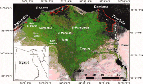
Figure 1. False colour composite of Landsat Thematic Mapper satellite of the Nile Delta. Green refers to agricultural lands. Numbers 1 to 4 refer to the coastal lagoons of Manzala (1), Burullus (2), Idku (3) and Maryout (4).
3 Results and discussion
shows the population distribution of the Nile Delta governorates in 2006, which reveals that El-Sharkia governorate has the highest population (>5 million), followed by El-Dakahlia, El-Behira, Alexandria, and El-Gharbia governorates (4–5 million). DEM analysis shows that 3617 km2 (18.1%) of the Nile Delta currently lies below sea level (). This area occurs mostly along the northwestern side of the delta and includes parts of Alexandria, El-Behira, and Kafr El-Sheikh governorates. The majority of this area is cultivated land around the northern lagoons of Burullus, Idku and Maryout. In addition, an area of 2548 km2 (12.7%) of the delta has an elevation between 0 and 1 m, particularly in the western section. It also extends south of Manzala lagoon and includes substantial urban neighbourhoods of Damietta, El-Dakahlia and Port Said governorates. Moreover, it is estimated that 2624 km2 (13.1%) of the delta land lies between 1 and 2 m elevation and includes all the coastal governorates between Alexandria and Port Said. The transition to higher (>2 m) grounds lies 60–80 km southward of the present shoreline position.
Figure 2. Population distribution of the Nile Delta governorates according to the Egyptian Central Agency for Mobilization and Statistics based on the last 2006 census.
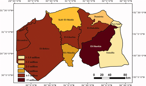
Figure 3. DEM classification for: Nile Delta today (top), 1 m sea level rise (middle) and 2 m sea level rise (bottom). Blue refers to areas to be flooded by the sea. Available in colour online.
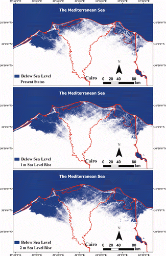
The importance of the densely populated Nile Delta and the expected sea-level rise and increased flooding is a cause for serious concern. Although currently 18.1% of the delta area, particularly the western delta, lies below sea level, these areas are protected from the sea by coastal defences, such as raised coastal ridges and coastal sand dunes. However, a sea level rise of 1 m could potentially flood a total area of 6165 km2, which represents all the land below 1 m elevation (30.8% of the delta), mostly comprising the western section of the delta and extending to the southern fringes of Lake Manzala. Loss of productive agricultural land, shoreline erosion and contamination of surface courses are the primary consequences of sea level rise. A sea level rise of 2 m will be catastrophic as potentially 8789 km2 (43.9% of the delta) would be flooded. In this situation, the people of four coastal governorates (Alexandria, Kafr El-Sheikh, Damietta and Port-Said; more than 8 million people) will be forced to abandon their settlements, and people in other three governorates (El-Behira, El-Dakhalia and El-Sharkia; more than 15 million people) will have to be partially relocated southward.
Taking into account the current rates of eustatic global sea level rise (1.8 mm/year, Church et al. Citation2004, and 2.5 mm/year, Cazenave et al. Citation2008) and excluding any other external factors or unforeseen climatic conditions, the sea level should rise only 0.18–0.25 m by the end of this century, which is not a major potential danger by itself. In addition, coastal sand dunes, coastal ridges and elevated coastal strips between Port Said and Alexandria act as the first barrier that help protect inland areas, particularly existing low-laying lands, from inundation and sea surges. The construction of the international coastal highway was also intentionally designed at 1–2 m above ground elevation for the majority of its tract along the delta coast. The northern bank of this road could perform a second obstacle against seawater flooding ().
Figure 4. (A) is the northern bank of the international coastal highway which rises by 1–2 m above ground level; (B) is the seawall constructed at Damietta promontory with an elevation of more than 2 m; and (C) shows practices of sand dune removal at the delta coast.
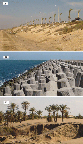
Delta submergence, however, could be accelerated by insufficient sediment delivery to the sea, increased delta subsidence and the removal of coastal sand dunes. Sediment delivery decreased annually at 84.4 million m3 since the construction of the High Dam (HD) across the Nile at Aswan in 1964, leading to increased erosion of the delta promontories (El-Fishawi Citation1989). Recorded rates of southward shoreline retreat after constructing the HD approached 76 m/year at Rosetta and 52 m/year at Damietta promontories (Frihy and Lawrence Citation2004). Elevated engineering structures were constructed to suppress erosion at these promontories (), but other areas have become more vulnerable to erosion and inundation during winter storms. Stanley (1988) reported a subsidence rate of up to 5 mm/year for the eastern side of the Nile Delta. This subsidence is mainly tectonic, yet, sediment compaction due to mining of over-pressured natural gas (Nashaat 1998) at the delta may enhance this subsidence. The removal of coastal sand dunes, which were formed over the past 2550 years (El-Asmar Citation2000), will also expand submergence across the delta coast (). These dunes are being levelled for cultivation or used as a sand source for building and construction purposes.
4 Conclusion
The rise of the sea level by 1 m would inundate more than one quarter of the Nile Delta area, while a 2 m sea level rise should relocate the shoreline 60–80 km southward of its current position. However, the current rate of sea-level rise is not a potential threat to the Nile Delta. More significant threats are blocking of sediment delivery to the coast, possible increased rates of subsidence and the removal of coastal dunes. Coastal zone managers should be aware of these threats and protect the coastal sand dunes and armour the shoreline.
Acknowledgements
The author deeply acknowledges two reviewers of the manuscript for their comments and invaluable suggestions.
Related Research Data
References
- Beaumont , P. 1993 . “ Climate and hydrology ” . In The Agriculture of Egypt , Edited by: Craig , G. M. 17 – 38 . New York : Oxford University Press .
- Becker , R. H. and Sultan , M. 2009 . Land subsidence in the Nile Delta: inferences from radar interferometry . The Holocene , 19 : 949 – 954 .
- Cazenave , A. , Lombard , A. and Llovel , W. 2008 . Present-day sea level rise: a synthesis . Comptes Rendus Geosciences , 341 : 761 – 770 .
- Church , J. , White , N. , Coleman , R. , Lambeck , K. and Metrovica , J. 2004 . Estimates of the regional distribution of sea level rise over the 1950–2000 period . Journal of Climate , 17 : 2609 – 2625 .
- Demirkese , A. C. 2008 . Digital terrain analysis using Landsat-7 ETM+ imagery and SRTM DEM: a case study of Nevsehir province (Cappadocia), Turkey . International Journal of Remote Sensing , 29 : 4173 – 4188 .
- El Banna , M. and Frihy , O. 2009 . Human-induced changes in the geomorphology of the northeastern coast of the Nile Delta, Egypt . Geomorphology , 107 : 72 – 78 .
- El-Asmar , H. and Hereher , M. 2010 . Change detection of the coastal zone east of the Nile Delta using remote sensing . Environmental Earth Sciences , DOI 10.1007/s12665-010-0564-9
- El-Asmar , H. 2000 . Geoenvironmental changes along Gamasa-Baltim coast, north of the Nile Delta, Egypt . Zeitschrift für Geomorphologie N. F , 44 : 59 – 73 .
- El-Fishawi , N. M. 1989 . Coastal erosion in relation to sea level changes, subsidence and river discharge, Nile Delta coast . Acta Mineralogica Petrographica , 30 : 161 – 171 .
- Farr , T. and Kobrick , M. 2000 . Shuttle Radar Topography Mission produces a wealth of data . EOS Transactions , 81 : 583 – 585 .
- Frihy , O. and Lawrence , D. 2004 . Evolution of the modern Nile delta promontories: development of accretional features during shoreline retreat . Environmental Geology , 46 : 914 – 931 .
- Ghoneim , E. and El-Baz , F. 2007 . The application of radar topographic data to mapping of a mega-paleodrainage in the Eastern Sahara . Journal of Arid Environments , 69 : 658 – 675 .
- Hereher , M. E. 2009 . Inventory of agricultural land of Egypt using MODIS data . Egyptian Journal of Remote Sensing and Space Sciences , 12 : 179 – 184 .
- Luedeling , E. and Buerkert , A. 2008 . Typology of oases in northern Oman based on Landsat and SRTM imagery and geological survey data . Remote Sensing of Environment , 112 : 1181 – 1195 .
- Nashaat , M. “ Abnormally high formation pressure and seal impacts on hydrocarbon accumulations in the Nile Delta and North Sinai basins, Egypt ” . In Abnormal Pressures in Hydrocarbon Environments , Edited by: Law , B. E. , Ulmishek , G. F. and Salvin , V. I. 161 – 180 . Tulsa, OK : AAPG Publications . (AAPG Memoir, 70)
- Potts , L. V. , Akylimaz , O. , Braun , A. and Shum , C. K. 2008 . Multi-resolution dune morphology using Shuttle Radar Topography Mission (SRTM) and dune mobility from fuzzy inference systems using SRTM and altimetric data . International Journal of Remote Sensing , 29 : 2879 – 2901 .
- Reuter , H. I. , Nelson , A. and Guevara , E. 2007 . An evaluation of void filling interpolation methods for SRTM data . International Journal of Geographic Information Science , 21 : 983 – 1008 .
- Sestini , G. 1992 . “ Implications of climatic changes for the Nile Delta ” . In Climatic Change and the Mediterranean , Edited by: Jeftic , L. , Milliman , D. and Sestini , G. 535 – 601 . London : Edward Arnold .
- Sneh , A. and Weissbrod , T. 1973 . Nile Delta: the defunct Pelusiac branch identified . Science , 180 : 59 – 61 .
- Stanley , D. J. 1988 . Subsidence in the northern Nile Delta: rapid rates, possible causes and consequences . Science , 240 : 497 – 500 .
- Stanley , D. J. and Warne , A. G. 1994 . Worldwide initiation of Holocene marine deltas by deceleration of sea-level rise . Science , 265 : 228 – 231 .