Abstract
The five provinces of southwestern China, Sichuan, Chongqing, Guizhou, Yunnan and Guangxi, frequently suffer from droughts, especially the recent severe drought of five consecutive months from autumn 2009 to spring 2010, which caused serious water shortages, huge economic losses and adverse social consequences. With increasing human activity in the last 200 years, the wetland areas have decreased and their ecological functions such as water conservation, climate regulation have declined, which has a direct impact on climate and the ecological environment. Using satellite images, changes in wetland areas of the five provinces of southwestern China have been mapped from 1970 to 2008. Our detailed analysis shows that the wetland area in the 1970s, 1990, 2000 and 2008 occupy an area of 20822.9, 18386.16, 19904.22 and 17269.72 km2, respectively, which indicate that the wetland areas have a downtrend, at an accelerating rate, from 2000 to 2008. Considering the complexity between wetland change and drought, the correlation between spatial and temporal wetland change and drought have been analysed using monthly ground meteorological data from 1971 to 2009, obtained from the China Meteorological Data Sharing Service Network. The analysed results show that the decrease of the wetland area, damage to biological resources and decline in climate regulation function are closely related to serious drought problems in the five provinces of southwestern China. Finally the corresponding solutions are discussed by analysing the problems faced by the wetland ecological system.
1. Introduction
Since the autumn of 2009, the five provinces (regions) of southwestern China (Guangxi, Chongqing, Sichuan, Guizhou and Yunnan) have been suffering with serious drought. According to an announcement from the Ministry of Civil Affairs, at 3:00 p.m. on 17 March 2010, statistics show that 51.049 million people were affected by drought, including 16.09 million people and 11.055 million livestock due to lack of drinking water. Due to this drought, agricultural crops in an area of 43 486 km2 were affected. The direct economic loss was of the order of 19.02 billion yuan, and the trend of the disaster was worsening (People's Republic of China Ministry of Civil Affairs Disaster Relief Division; http://jzs.mca.gov.cn/article/zqxx/gzdt/201003/20100300062898.shtml).
Located in the transition zone from the Qinghai-Tibet Plateau to the eastern and southern plain, the five provinces (regions) of southwestern China are very important agricultural areas with varying topography. With a thin layer of soil, soil erosion is a serious problem in this region. The rainfall is irregular spatially and temporally (Zhu et al. Citation2006). The frequency of continuous drought is high (Wang and Sun Citation2002). Earlier studies have shown that recurring drought will cause serious water shortages with huge economic losses and adverse social consequences (Thenkabail et al. Citation2004). However water is the lifeblood of wetlands, affecting the ecological processes of the wetland ecosystem and the life courses of all wetland biology.
Organized by the State Forestry, the first nationwide large-scale wetland resources survey since the founding of China was carried out from 1995 to 2003. According to the survey results, the area of natural wetlands in the five provinces of southwestern China is 19 757 km2, accounting for 5.46% of the national natural wetlands (Lei and Zhang Citation2005). Due to escalating human socioeconomic activities over the last 200 years the wetland area has been decreasing (Brinson and Malvarez Citation2002). Changes in the water level and the decline of wetland areas may have reduced the ecological function of the wetland (Ignacio et al. Citation2010), thus understanding wetland changes and their influencing factors is important for protecting wetland resources (Stacy and Marvin Citation2002). To date, countries such as the United States and China have made progress in wetland mapping and research based on remote sensing. These countries have basically completed the wetland mapping of their countries and carried out some statistical analysis of wetland change (Niu et al. Citation2009); Stacy and Marvin (Citation2002) compared several methods for classification and investigation of wetlands using remote sensing images. The remote sensing technique is proved to be an important tool for mapping the wetlands, especially in developing countries where road networks are poor and also due to lack of funds (Stacy and Marvin Citation2002). In addition, we can do in-depth research on spatial and temporal changes of wetlands and their landscape pattern combined with prior knowledge and historical images. Xiao et al. (Citation2010) studied the landscape pattern changes of Sichuan Zoige wetland from 1990 to 2007 using remote sensing and geographic information system technology; H. Liu et al. (Citation2004a) studied the spatial and temporal changes of landscape structure of the past 50 years in Sanjiang Plain wetland. However, there are few papers that discuss the relationship between shrinkage of the wetlands and specific ecological problems.
In this paper we examine information regarding wetland changes over the past 40years in the five provinces of southwestern China based on multi-source remote sensing data. We then analyse the relationship between drought, temperature, precipitation and reduction of the wetland area, in order to reveal the relationship between the reduction of the wetland area and serious drought, as well as providing ascientific basis for further research of the wetland functions such as water conservation, climate regulation and rational use and protection of wetlands.
2 Methodology
2.1 Overview of the study area
Guangxi, Chongqing, Sichuan, Guizhou and Yunnan are located in southwest China, with a total area of about 1.37 million km2, and account for about 14% of China's total land area (The People's Republic of China Central People's Government 15 June 2005; http://www.gov.cn/test/2005-06/15/content_18253.htm). This region was the hardest hit by a serious drought lasting from autumn 2009 to spring 2010. Mountains and plateaus are the main landform in the region, accounting for 68.64% of the cover area, and are mainly distributed in the western Sichuan Plateau, Yunnan-Guizhou Plateau and mountains around Sichuan Basin. Hills account for 23.02% of the cover area, and are mainly distributed in the Sichuan Basin and the Guangxi Basin. Plains, including platform, account for only 8.34% of the cover area and are mainly distributed in the Chengdu Plain, the Yangtze River coastal area and southeastern Guangxi. The annual rainfall is abundant in these areas, and in most parts reaches 800–1400 mm, with a latitudinal distribution decreasing from the southeast (1600 mm) to the northwest (500 mm). The rainfall distribution is complex due to the effect of monsoon and topography. The annual evaporation is 1000–1300 mm in the northeast, 1500–1800 mm in the western and southern areas and up to 2000–3800 mm in the Sichuan-Yunnan dry-hot river valley area, which is 3–5 times the rainfall of those areas, and thus makes it a semiarid region. Rainfall and runoff are the main water resources. Affected by the monsoon, the rainfall in the southeast is concentrated in June–September and the annual change is relatively large (Wang et al. Citation2005).
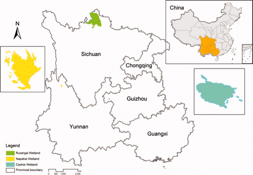
The Zoige Plateau Wetland Nature Reserve is located in the northern Zoige Plateau (102° 29′–102° 59′ E, 33° 25′–34° 00′ N), with an elevation of 3422–3704 m. It is the world's largest plateau wetland and China's first large plateau swamp wetland. It was included in the international important wetland directory in February 2008 (http://www.ramsar.org/). The main terrain there is gentle hill. High mountains are less; plateau meadow soil and peat marsh soil are widely developed there. Known as ‘the kidney of the Plateau’, the Zoige Plateau is a significant ecologically functional area of water conservation along the upper Yellow River as well as an important conservation area of biodiversity in China. It has a typical continental cold-temperate humid and semi-humid highland monsoon climate, of which the cold climate feature is obvious and the continental climate feature is significant. It is the rainy area of the Yellow River Basin with an average annual rainfall of 600–800 mm. Rivers inland mostly belong to the Yellow River Water System, and the Hei River and Bai River are the main tributaries. Subalpine meadow and swamp vegetation are the main vegetal cover there (Tian et al. Citation2004).
Located at the Jinsha River Basin, the Yunnan Napahai Wetland stands in the northwest of Yunnan province (99° 37′−99° 43′ E, 27° 49′−27° 55′ N), with an elevation of 3260 m. It is one of the highest and northernmost plateau lake wetlands in Yunnan province and is a typical wetland suffering serious swamping and degradation (Yu Citation2005). It was included in the international important wetland directory in July 2004 (Bai et al. Citation2008).
Located in Weining County (104° 12′ E, 26° 48′ N), the Caohai Lake wetland has an elevation of 2171.7 m and is the largest natural freshwater lake of Guizhou Province. The Caohai Lake wetland is a National Nature Reserve that exists mainly for the protection of the plateau wetland ecosystem and some rare birds such as black-necked cranes (Gong et al. Citation2010). The Caohai Lake wetland dried up in 1893, 1958 and 1972 because of human activity. The Guizhou provincial government decided to restore Caohai Lake wetland in 1981, and as a result, 25 km2 of water surface was restored and 27 million m3 of water was stored ().
Figure 1. Distribution map of the study area.
2.2 Data sources and processing
We have taken Landsat Multispectral Scanner (MSS), Thematic Mapper (TM) and Enhanced Thematic Mapper Plus (ETM+) images covering five provinces of southwestern China (http://glcf.umiacs.umd.edu/data/2007) to extract wetland information. A total of 76 scenes of Landsat MSS images from 1972 to 1979 were used to extract the water and prepare a distribution map of the 1970s. A band combination of 4, 2, 1 is considered as Red, Green and Blue channels, respectively. The Landsat MSS images of the five provinces of southwestern China were processed by the supervised classification group by group. After this a second classification and band computation was carried out on images with low classification precision to extract water. Finally the maps of water distribution were mosaicked. Selecting Albers projection with two standard parallels, the water distribution grid map of the 1970s was gained by using the 1:1 000 000 national vector map to subset the area of the five provinces of southwestern China. Because of the poor image quality, classification results were reprojected to ArcMap9.2 in order to produce the water distribution map of the 1970s by artificial visual interpretation with a screen scale of 1:20 000–1:60 000. The wrong and omissive classification water was corrected, with ariver being wider than 3 pixels (90 m) and a lake larger than 10 ×10 pixels (0.09 km2).
Based on Landsat TM/ETM+ images with a resolution of 30 m, the wetland distribution maps of 1990, 2000 and 2008 were acquired by using a wetland classification system () as well as according to historical data and artificial visual interpretation with a river being wider than 3 pixels (90 m) and an area larger than 10 × 10 pixels being a lake (0.09 km2). Geometric precision was controlled to within 1:100 000 when drawing, and multiple auxiliary data such as digital elevation models (DEMs) and Google Earth data were used to verify and proofread the interpretation results (Daily 1997, Niu et al. Citation2009).
Table 1. Wetland classification system based on remote sensing (Niu et al. Citation2009).
The monthly dataset of the ground meteorological data of China from 1971 to 2009, downloaded from the China Meteorological Data Sharing Service Network (http://cdc.cma.gov.cn/) was taken as the basic data source. A total of 228 meteorological stations distributed over Guangxi, Chongqing, Sichuan, Guizhou and Yunnan and their buffer zone within 200 km was selected, and the meteorological data were stored and managed using a Microsoft Office Access database after excluding null value records according to data explanation. Adjacent sequence meteorological data of the 1970s, 2000 and 2008 were gained by averaging and cumulating the data of each time. Comparing the area of wetland and the meteorological data, the datasets of the Zoige station and the stations around it were selected for the statistical analysis after averaging all the values of the datasets.
For the spatial and temporal dynamic changes of the Sichuan Zoige wetland, the Yunnan Napahai wetland and the Guizhou Caohai Lake wetland, we took the Landsat MSS, TM, ETM+ and HJ-1A/B images covering the study areas as basic data sources. Working with ENVI4.5 and ArcMap9.2, raw images were corrected and other processing work under ENVI4.5 and then artificial visual interpretation was done under ArcMap9.2 to extract the dynamic change information of typical wetlands referring to international important wetland research and Google Earth images.
3 Results and discussion
3.1 Analysis of wetland changes of the five provinces of southwestern China
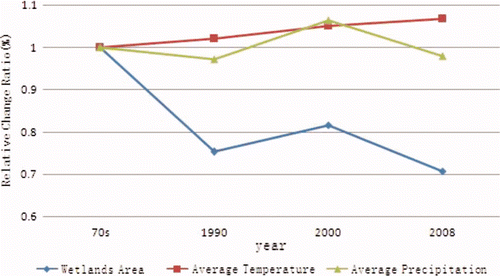
Wetlands in the five provinces of southwestern China are mostly distributed along rivers, and the main types are river, marsh and floodplain in the north and northeast, and river, estuarine delta and coastal marsh in the southeast near the South Sea ofChina. , and show that the wetland area of the five provinces of southwestern China in the 1970s, 1990, 2000 and 2008 are 20 822.93, 18 386.16, 19 904.22 and 17 269.72 km2, respectively ().
Table 2. Wetland area of the five provinces of southwestern China in the 1970s, 1990, 2000 and 2008 based on remote sensing interpretation (unit: km2).
Figure 2. Wetland distributions in the five provinces of southwestern China in the 1970s.
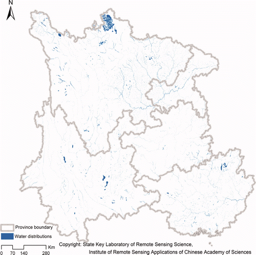
Figure 3. Wetland distributions in the five provinces of southwestern China in 2000.
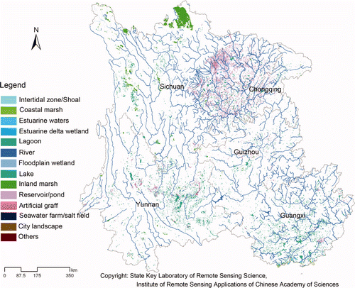
Figure 4. Wetland distributions in the five provinces of southwestern China in 2008.
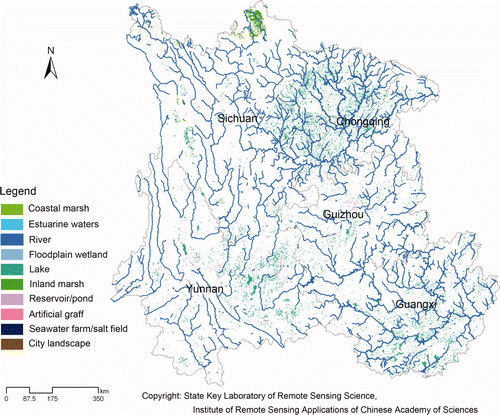
The above results show that the total reduction of wetland area in the five provinces of southwestern China is 3553.21 km2 during the 40 years from the 1970s to 2008, accounting for about 17% of the total area, thus the average annual reduction of area is about 88.83 km2. shows the change of wetland area presents a negative correlation with temperature, and a positive one with precipitation. The reduction rate is comparatively fast from 2000 to 2008, and the average annual reduction area is 329.31 km2, in which estuarine delta wetland, lagoon and intertidal zone even disappear. The area of floodplain wetland shows the greatest change of all types of wetland, up to 930.29 km2, followed by inland swamps, up to 595.43 km2. The reduction of reservoirs and rivers is also found to be larger at about 423.84 km2 and 276.08 km2, respectively. In addition to the disappearance of wetlands, the reduction rate of coastal marshes, seawater farm and salt field is found to be larger (over 75%), followed by reservoir pond, city landscape, entertainment water surface and floodplain wetland (over 60%) ().
Table 3. Wetland area of the five provinces of southwestern China in 2000 and 2008 based on remote sensing monitoring (units: km2).
Figure 5. Average annual monthly temperature change of the five provinces of southwestern China.
3.2 Analysis of wetland degradation
Wetland has many functions such as flood diversion and storage, water conservation, regulation of regional climate, shoreline protection, water quality improvement and groundwater recharge (Xie et al. Citation2010). As the population increases rapidly, in order to solve the expansion situation of production and living space and economic development issues, a series of human disturbance activities have occurred. These include, for example, land reclamation, overgrazing, drainage, irrigation and other agricultural land reclamation, urbanization, water projects, industrial activities and tourism, which continuously take water and change the cycle of water, organics and inorganics. In general, natural and human factors are the two main factors that affect ecosystem changes. Factors directly affecting the ecosystem include climate change, freshwater flow, nitrogen loading, over-harvesting, sediment deposition, water temperature change and species invasion, while indirect factors include population growth, economic development, social politics, technological progress, social culture, lifestyle and religion (Millennium Ecosystem Assessment Citation2005).
3.2.1 Natural factors of wetland degradation.
Natural factors affect the formation and distribution of wetlands, such as geological structure, topography, climate, hydrology, vegetation and soil. Geological structure and topography are formed in geological history and do not change over short periods. Meteorological factors and climate play a leading role on the ecological environment (Xie et al. 2010). Climate is the basis of wetland formation and development. The impact of climate change on wetland is reflected in temperature and precipitation. Climate change may affect the energy flow, productivity, distribution and wetland function of wetland ecosystems. Meanwhile, the instability of wetlands can change the wetland ecosystem, accelerating climate change. Precipitation is the direct reason for the continuous decline of wetland areas, and a decrease of continuous rainfall can lead to wetland weakening and degradation. The impact of global climate change frequently exacerbates wetland degradation (Millennium Ecosystem Assessment 2005).
3.2.2 Human factors of wetland degradation.
Human activities are becoming a major factor in wetland change. However, human activities can accelerate or prevent wetland degradation, depending on how they change the relationship between human and nature. Population growth and economic development are the two main forces resulting in wetland degradation, which may lead to urban sprawl and shrinking of inland and coastal wetland. Lack of basic economic information, unreasonable market situations and economic subsidies are the economic driving forces leading to the loss of many wetlands. Reclamation, cutting, transformation and draining of wetland for agricultural development are the main factors of loss ofglobal inland wetlands (Millennium Ecosystem Assessment 2005).
Wetlands are a source of income for local people who are also the most direct beneficiaries of wetland protection. For the limitations of understanding, people often pay more attention to the individual living sources but not the protection of wetland. Meanwhile, the government and regulators do not take into account the livelihood of the residents, making local residents continuously reclaim wetlands to maintain their living standards. Many of the original wetland landscapes have been replaced by artificial landscapes.
For stability a wetland ecosystem needs a stable source of water such as the cyclical stability of river flooding and groundwater. Hydrological conditions can directly change the physical and chemical properties of wetlands, which in turn affectstructure, primary productivity and nutrient cycling. Scarcity and limitation of water resources also influence wetland ecosystems, threatening human society and hindering economic development, as well as having a negative impact on grain production and human health.
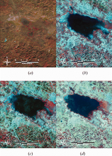
On the other hand, measures for wetland planning, conservation and management are missing and inappropriate, such as the ill planning and management of wetland nature reserves, weak legal means and lack of monitoring, protection and evaluation research. The Guizhou Caohai Lake wetland almost dried up due to human impact in the 1970s, and the water area was only 3.61 km2 in 1976. Through treatment and recovery in the 1980s, the area of the Caohai Lake wetland once reached 28.56 km2 in 1992. However, Caohai Lake began to degrade at the rate of 4 km2 per 10 years due to inadequate protection during the subsequent 20years. At present, the water area of Caohai Lake is only about 20.18 km2 ().
Figure 6. Area of Caohai Lake wetland in each period extracted by remote sensing images. (a)1976, (b) 1992, (c) 2001, (d) 2010.
3.3 Correlation analysis between wetland degradation and drought
As one of the most complex ecosystems in the world, wetlands are multifunctional ecological systems. Wetlands play an irreplaceable role in water storage, regulating runoff, purification, filtration, climate regulation, and provision of habitat and maintain ecological balance in a region. As a unique ecological system, wetlands have an environmental regulation function and ecological benefits (Lv 2004).
The most direct output of wetland is water, which is the recharge source of natural reservoirs and groundwater. However, various ecological and environmental problems that wetlands face currently, such as shrinking and water reduction, may lead to changes in wetland structure and function, and then result in loss or decreasing of wetland function (Cui 2006).
Drought is a common meteorological disaster resulting from extreme climate or abnormal shortage of water. Its formative factors are comparatively complex, relating to the distribution of plant systems, temperature equilibrium distribution, changes of atmospheric circulation status and changes in the distribution of chemical elements, etc. However, the most direct reasons for drought can be deficient rainfall, high temperature, large moisture evaporation, and long duration. Since wetland ecosystems can have an impact on some climatic factors such as temperature, rainfall and evaporation in terms of water by direct or indirect ways, there may be some correlation between the change of wetland ecosystem and serious drought. Based on the analysis above, this paper will analyse the correlation between wetland change and the droughts that occurred in southwestern China during September 2009 to May 2010.
3.3.1 The role of wetland on local climate.
Carbon circulation in wetland plays an important role in global climate change. Wetland is also one of the important control factors of the global circulation of many substances such as nitrogen, sulphur, and methane. By adjusting precipitation unevenly distributed on space-time, wetland can also help avoid flood and drought as well as regulate the micro-climate of local regions.
Wetland is a type of nature land with a large amount of water. On one hand, due to excessive water in the wetland soil and the high heat capacity of water, it is hard for the ground to get warmer. On the other hand, wetland evaporation can increase air humidity and help adjust rainfall, meaning wetland has a good effect on the natural circulation of water. Moreover, the greater the evaporation, the more calories would be consumed: wetland, with an evaporation of 2–3 times that of water surface evaporation leads to a colder and wetter climate around. In addition, transpiration of wetland plants control the humidity and rainfall of local areas. Thewetland plays a very important role in regulating the local climate.
3.3.2 General causes of drought and analysis of this drought.
Drought is mainly due to low rainfall, high temperature, and large evaporation. Continuing drought and untimely measures result in yield reduction of farmland or loss of urban industrial production, which formed the drought. Continuous low rainfall, lasting high temperature, large evaporation, early termination of the rainy season and less water storage are the main reasons for serious drought in the five provinces of southwestern China. Since the beginning of 2000, provinces such as Yunnan, Guizhou and surrounding areas have experienced low rainfall and high temperatures. From September 2009 to May 2010, the rainfall in most parts of Yunnan, Guizhou, Chongqing, Sichuan and some parts of Guangxi provinces was reduced by over 50%, some of which were reduced by 70% to 90% (the average precipitation of Yunnan and Guizhou was only 173 mm and 175 mm, respectively). The precipitation of southwestern regions during this period was found to be the lowest since the first meteorological records i.e. year 1951. By mid March 2010, the reservoir and pond storage water of Yunnan province was only 4.6 billion m3, nearly 1800 million m3 less than that of the same period last year, while the average temperature throughout the winter of Yunnan reached the highest level since 1950. Meanwhile, Yunnan is the cross and transition zone that was affected by many kinds of monsoon winds circulation, including the East Asian monsoon, the South Asian monsoon, and the plateau monsoon. Thus Yunnan is a typical monsoon climate region of China. Monsoon winds in Yunnan province lead to the inevitability of ariddisaster, and unstable monsoon wind activity has resulted in the randomness ofthe arid disaster occurrence. In addition, waste and loss of water resources resulting from mismanagement of water resources is another reason for aggravated drought.
3.3.3 The interaction between wetland changes of the five southwestern provinces and drought.
Water shortages caused by serious drought make the water supply of wetlands unstable, resulting in instability of the wetland ecosystem and accelerating climate change. In addition, water and heat conditions have an impact on wetlands. Maintenance of the hydrological services of wetlands can maintain the ecological character of wetlands, biodiversity and regulate the supply services. Temperature changes affect the evaporation, and reduction of precipitation decreases the water supply of wetlands. In return, human objectives for meeting urban and agricultural activities increase the demand for fresh water, leading to runoff reduction, water level fluctuation and degradation of wetland functions.
Wetland dewatering, sod layer destruction, change of composition, structure andtype of wetland plant community and succession of vegetation marsh system strongly caused by serious drought reduce the flood storing and soil conservation functions of wetlands. The anaerobic environment of carbon sinks change, and mineral results in a lot of carbon dioxide and methane being released into the atmosphere. The original vegetation evolves to the medium budding or xerophytic vegetation. As vegetation coverage declines, surface transpiration and evaporation expands, and the extent of drought, salinization and sandstorms intensify. Decomposition of biological residues increase to release more carbon dioxide into the atmosphere, and this can induce methane emissions from wetlands.
In short, shrinking of wetland areas leads to a decrease in the water conservation ability of wetlands and further declining regulatory functions for local climate as well as the regional climate anomalies (such as temperature rising, rainfall reducing and evaporation rising), which may result in the occurrence of drought. In turn, drought disaster can result in wetland dewatering, wetland area shrinkage, and reduced capacity of wetland water storage as well as water supply, thus leading to longer periods of drought and ecosystem imbalance.
This drought has caused more than 660 rivers to dry up in Yunnan Province. At Yunnan Dianchi Lake, the largest freshwater lake of the Yunnan-Guizhou Plateau, the water level dropped by nearly 1.2 m. Many shallow lakes have nearly dried up, and the wetland has seriously shrunk. With the decline of the groundwater level in many marsh wetlands, marsh grass has turned to meadow or wasteland. Large areas of lakeside marsh wetland have disappeared. At Napahai wetland, which is an internationally important wetland in the northwest of Yunnan, the water level quickly dropped to a record low level of 20–30 cm, from the average annual of 1–1.5 m surrounding. Under the extreme droughts, the native biological communities of the plateau wetland suffer a fatal blow, the composition, structure and function of its biological diversity changed, leading to degradation and loss of ecosystem function, and the subsequent serious consequences were irreversible. In addition, temperature increase and precipitation change are the main climate factors affecting wetland distribution and function. Wetlands have an obvious cooling and wetting effect for the local climate. Evaporation and transpiration of wetlands can maintain local humidity and rainfall. Morning fog resulting from wetland can reduce the loss of soil moisture around to control the regional normal circulation of the atmosphere, and make the regional climatic conditions stable. The change of wetland water status, coupled with the sharp reduction in wetland water, influences greatly the lake climate regulation function, leading to an increase in temperature during summer. The increase of high temperature exacerbates the extent of drought; salinization and sandstorms lead to regional environmental degradation and increase the occurrence of drought.
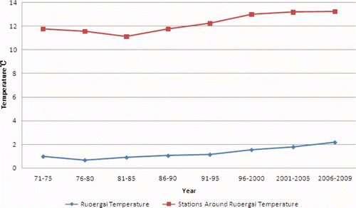
Since the 1970s, the area of the Zoige wetland reduced at a rate of about 10 km2 per year, from 3518.6 km2 in 1977 to 2738.7 km2 in 2010, which means the proportion is about 22% (). Reduction of wetland area, significant loss of vegetation area, serious desertification and the decline of function of water storage and water conservation, as well as the effect of over-grazing, excessive felling, artificial wetland drainage, climate, changes of soil physical and chemical properties and other factors, lead to the biological resources of wetland ecosystems suffering loss and the benign cycle has been destroyed, leading to a loss of wetland ecological functions, and therefore water supply can not be guaranteed in times of drought, which intensifies the drought to some extent. The Sichuan Zoige wetland is the largest plateau wetland of the world, and the Zoige weather station was established as early as 1957. Compared with the average values of stations around the Zoige station the monthly precipitation/temperature of the Zoige meteorological station, decreased over time and the monthly precipitation of the Zoige meteorological station is generally slightly higher than the average values of the surrounding stations while the monthly temperature is the opposite ( and ). The comparison between the Zoige station and its surrounding stations shows that wetland has some effect on microclimate regulation.
Figure 7. Spatial and temporal sequence map of Sichuan Zoige wetland.
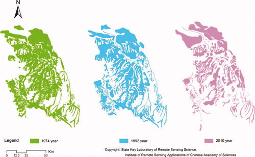
Figure 8. Average monthly precipitations of Zoige station and surrounding stations.
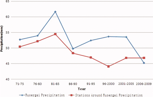
Figure 9. Average monthly temperatures of Zoige station and surrounding stations.
4 Conclusion
The wetland distributions and areas of the five provinces of southwestern China in the 1970s, 1990, 2000 and 2008 show that the total reduction of wetland area was 3553.21 km2 in the five provinces of southwestern China from 1970 to 2008, accounting for about 17% of the ground area, and thus the average annual reduction area is about 88.83 km2. The reduction rate was comparatively fast from 2000 to 2008 with an average annual reduction of 329.31 km2. The changes to the wetland area show a negative correlation with temperature, and a positive correlation with precipitation. Due to the limitation of time and conditions, we used the remote sensing classification technique combined with artificial visual interpretation to extract only the area of water in the 1970s, which is not the same classification system as that of 1990, 2000 and 2008. So refinement is necessary in future studies.
Drought most notably represents poor precipitation, while water is the life of wetlands, therefore, frequent droughts reduce wetland areas, which leads to damage of biological resources and decline of hydrological function and climate regulation function. On the other hand, due to various factors, reduction of the wetland areawould reduce the function of flood storage, control and climate regulation of wetland, increasing the risk of regional climate anomalies. So it is imperative to protect wetlands.
Wetland change and its causes are the topic of global environmental change (H.Liu et al. Citation2004a). Through the absorption and emission of large quantities of carbon, wetlands play an important role in the regulation of global climate change. Study of the dynamic changes of wetland is important to the protection of wetland biodiversity and its sustainable management. Wetland benefits and its ecological evaluation are the basis of wetland protection and rational utilization (Millennium Ecosystem Assessment Citation2005). The significance of wetland evaluation is not an economic value we actually use, but is a tradeoff between the wetland values and other economic benefits during management and decision-making. A reasonable assessment of wetland health is a guarantee of human health.
Acknowledgments
This paper has been supported by ‘Assessment system for wetland ecosystem’ by theState Forestry Administration, P.R. China; the Natural Science Foundation of China (grant no. 40871173); National State Key Basic Research Project (grant no. 2007CB714404); Special Grant for Prevention and Treatment of Infectious Diseases (2008ZX10004-012). The authors would like to thank their several colleagues for reading the paper and giving their valuable suggestions that have helped to improve earlier versions of the paper.
References
- Bai , J. H. , Ou Yang , H. , Cui , B. S. , Wang , Q. G. and Chen , H. 2008 . Landscape pattern changes of Zoige alpine wetland during the past 40 years . Ecological Journal , 5 : 2245 – 2252 .
- Brinson , M. M. and Malvarez , A. I. 2002 . Temperate freshwater wetlands: types, status, and threats . Environmental Conservation , 29 : 115 – 133 .
- Cui , B. S. 2006 . Wetland Science , Beijing : Beijing Normal University Press .
- Daily , G. C. 1997 . Nature's Services: Societal dependence on natural ecosystems , Washington , DC : Island Press .
- Gong , P. , Niu , Z. Z. , Cheng , X. , Zhao , K. Y. , Zhou , D. M. , Guo , J. H. , Liang , L. , Wang , X. F. , Li , D. D. , Huang , H. B. , Wang , K. , Li , W. N. , Wang , X. W. , Ying , Q. , Yang , Z. Z. , Ye , Y. F. , Li , Z. , Zhuang , D. F. , Chi , Y. B. , Zhou , H. Z. and Yan , J. 2010 . The wetland changes with remote sensing of China in 1990 and 2000 . Science in China Series D: Earth Sciences , 40 : 768 – 775 .
- Ignacio , M. P. , Jose , N. P. , Ignacio , G. and Magaly , K. 2010 . Detecting drought induced environmental changes in a Mediterranean wetland by remote sensing . Applied Geography , 30 : 254 – 262 .
- Lei , K. and Zhang , M. X. 2005 . Wetland resources and conservation suggestions in China . Wetland Science , 3 : 81 – 86 .
- Liu , H. Y. , Zhang , S. K. and Lv , X. G. 2004a . Spatial and temporal changes of landscape structure of Sanjiang Plain . Geography Journal , 59 : 391 – 400 .
- Lv , X. G. 2004 . Protection and Management of Wetland Ecological System , Beijing : Chemical Industry Press .
- Millennium Ecosystem Assessment . 2005 . Ecosystem and Human Well-Being: Wetlands and water , Washington , DC : World Resources Institute .
- Niu , Z. G. , Gong , P. , Cheng , X. , Guo , J. H. , Wang , L. , Huang , H. B. , Shen , S. Q. , Wu , Y. Z. , Wang , X. F. , Wang , X. W. , Ying , Q. , Liang , L. , Zhang , L. N. , Wang , L. , Yao , X. , Yang , Z. Z. , Guo , Z. X. and Dai , Y. J. 2009 . Preliminary remote sensing mapping and associated analysis of geographical features of China wetlands . Science in China Series D: Earth Sciences , 39 : 188 – 203 .
- People's Republic of China Ministry of Civil Affairs Disaster Relief Division . http://jzs.mca.gov.cn/article/zqxx/gzdt/201003/20100300062898.shtml (accessed March 2010)
- Stacy , L. O. and Marvin , E. B. 2002 . Satellite remote sensing of wetlands . Wetlands Ecology and Management , 10 : 381 – 402 .
- Thenkabail , P. S. , Gamage , M. S.D.N. and Smakhtin , V. U. 2004 . “ The use of remote sensing data for drought assessment and monitoring in Southwest Asia ” . IWMI Report 85
- Tian , K. , Lu , M. , Chang , F. L. , Mo , J. F. , Li , L. C. and Yang , Y. X. 2004 . Ecological environmental changes and the driving mechanisms of Yunnan Napahai Karst wetland . Lake Science , 16 : 35 – 42 .
- Wang , J. A. and Sun , H. 2002 . Spatial and temporal changes of drought in China in recent 50years . Natural Disasters , 11 : 1 – 6 .
- Wang , Y. , Zhao , Z. Z. , Qiao , Y. S. and Li , C. Z. 2005 . Climate change characteristics and itsimpact on the local ecological environment of Zoige during the past 45 years . Geomechanics Journal , 11 : 328 – 340 .
- Yu , Y. X. 2005 . “ Study of regional environmental bearing capacity of Caohai plateau wetland ” . Guiyang : MSc, Guizhou Normal University .
- Xiao , D. R. , Tian , B. , Tian , K. and Yang , Y. 2010 . Landscape patterns and their changes inSichuan Zoige Wetland National Nature Reserve . Acta Ecologica Sinica , 30 : 27 – 32 .
- Xie , Z. L. , Xu , X. G. and Yan , L. 2010 . Analyzing qualitative and quantitative changes in coastal wetland associated to the effects of natural and anthropogenic factors in a part of Tianjin, China . Estuarine, Coastal and Shelf Science , 86 : 379 – 386 .
- Yu , G. Y. 2005 . Views of some basic problems on wetland researches . Progress in Geography , 20 : 177 – 183 .
- Zhu , Z. L. , Zhao , X. J. , Wang , C. T. and Hou , L. C. 2006 . Drought laws and water-saving agriculture development in Southwest regions . Ecological Environment , 15 : 876 – 880 .