Abstract
The floods in the parts of the north-west Himalayan region caused severe damage in the Uttarakhand state of India and in some parts of western Nepal. The severity of the floods and damage was maximum in the Kedarnath region, home of a very famous Hindu pilgrimage. It caused the death of about 4000 people and almost a similar number are still missing. The flash floods were mainly caused by the heavy rainfall, triggering landslides in some places, damaging buildings and infrastructures. The extensive damage and large death toll expose the vulnerability of the mountainous region and lack of coordinated relief and rescue operation.
1. Introduction
India and adjoining regions are vulnerable to natural catastrophic events, namely earthquakes, landslides, floods, drought, cyclones and cloudburst. Amongst them, floods are most disastrous and quite frequent natural catastrophe causing great loss to human lives and property. Previous disastrous floods include (i) Mumbai floods of 26 July 2005, killing about 5000 people (Prasad & Singh, Citation2005) caused by 994 mm of rain in one day, (ii) Bihar floods of 18 August 2008 that killed about 434 people, caused by breach of Kosi river embankment, (iii) Pakistan floods of July 2010 affecting more than 20 million people and killing more than 2000 people (Gaurav et al. Citation2011; Webster et al. Citation2011), (iv) Leh floods of 6 August 2010 and (v) Gujarat floods of June 2005. The Himalayan region too is prone to rain-induced hazards that occur in the form of flash floods, cloudburst and glacial lake outburst. Among them, the flash floods and cloudbursts are very common (Joshi & Kumar Citation2006). The recent Kedarnath disaster is the excessive rainfall-induced flash-floods-associated disaster and is now the worst flood-related disaster in India, in terms of loss of human lives and the damage caused by it. Here, in this article, we discuss the event, possible causes and lessons learnt.
During 16–17 June 2013, about a 600-km-long central segment (between ∼77°E to 82°E longitude) of the Himalayan ranges witnessed unprecedented rainfall () followed by flash floods in about 25 major snow-fed rivers () and their tributaries, causing destruction on a scale not recorded ever before. These floods occurred in the period when Hindus all over India and neighbouring countries visit the four pilgrimages in Garhwal Himalaya, the Yamunotri, Gangotri, Kedarnath and Badrinath. These are referred as “Dhams” (abodes) of Garhwal. They are all located in the state of Uttarakhand, India, with neighbouring Nepal to its east. During these floods, the worst affected region was the Kedarnath. Although the damage was mainly caused by a hydrometeorological process, the floods, for the sake of brevity, here we provide a broader perspective. Some of these factors might have actually increased the extent of damage. Geologically, Kedarnath is located in the southern Higher Himalayan region (). The rocks found in this region are generally high-grade metamorphic rocks, with granite intrusion at some places. The metamorphism takes place under amphibolite to locally lower granulite facies conditions (Valdiya Citation2010). The topographic gradient is relatively steep in the Higher Himalayan region than in the Lesser Himalayan region, which is also evident from the river profiles. They all show a knickpoint (very high gradients) close to the Main Central Thrust (MCT), a thrust between the Lesser Himalayan region and the Higher Himalayan region (Seeber & Gornitz Citation1983). From an earthquake occurrence point of view, Kedarnath region occupies a very important position. It is located within the Himalayan seismic belt. To its west and east, strong magnitude earthquakes of 1991 Uttarkashi (Mw 6.8) and 1999 Chamoli (Mw 6.6), respectively, occurred. More importantly, it is located on the down-dip edge of the locked detachment that lies under the Outer and Lesser Himalayan region (Bilham et al. Citation1997; Jouanne et al. Citation1999; Avouac Citation2003; Ader et al. Citation2012). Thus, it lies in the region that marks the transition of the underlying aseismically slipping detachment to the north from the locked detachment to the south (Gahalaut Citation2008). Strain accumulation on the locked detachment causes maximum uplift in such regions all along the Himalayan region (Gahalaut & Chander Citation1997).
Figure 1 Tropical rainfall measuring mission (TRMM) of NASA showing rainfall on 17 June 2013 (Source: http://trmm.gsfc.nasa.gov). The violet colour indicates rainfall of about 350 mm. White triangle denotes the location of Kedarnath
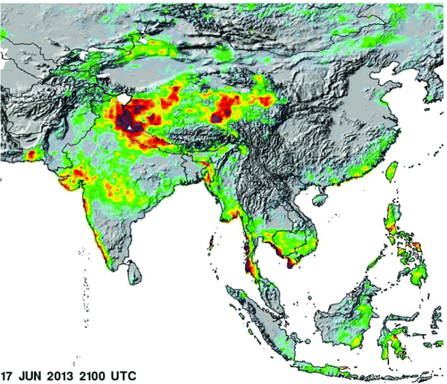
Figure 2 A pre- and post-flood image of the Uttarakhand, and western Nepal and adjoining Tarai region from MODIS on NASA's aqua satellite (Source: http://earthobservatory.nasa.gov/IOTD/view.php?id=81450). Note high discharge in the rivers in the post-image
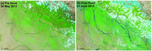
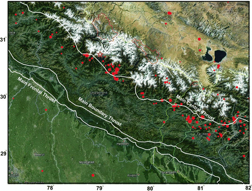
Figure 3 Location of Kedarnath along with the earthquakes of past 50 years (red dots) over Google earth
2. The fury of the flood
The flash floods killed about 4000 people and caused unprecedented damage to the roads (through slope destabilization), habitats, tourism and business industry, hydroelectric projects, agriculture and so on. During the disaster more than 100,000 pilgrims were in the region, besides about 3 million local residents. Unofficial claims put the death toll at more than 10,000, damage to about 8000 km motor roads, and severe damage to 200 bridges. At least 30 hydropower projects under construction or completed have been either completely destroyed or severely damaged. About 30 governmental establishments including paramilitary camps, guest houses, food outlets, government offices and schools have also been destroyed either completely or partially. An initial assessment made by us suggests that more than 5000 hill villages and thirty urban clusters of the hills have been affected severely. The famous Kedarnath shrine was completely damaged, though the temple survived.
3. The event
During 15–17 June 2013, exceptionally heavy rains occurred in this part of the Himalaya. Normally the timing of arrival of south-west summer monsoon (from the Arabian sea) in this region is the last week of June to the first week of July, but this year it arrived two weeks early. According to the India Meteorological Department, this happened because of a low-pressure trough that was formed above north India. Due to this low-pressure zone, the monsoon winds were deviated from their natural path, i.e. first towards north-east India and then towards northern India. Instead they directly moved northwards after taking moisture from the Bay of Bengal. At the same time, westerlies were active in this region in the form of pre-monsoon showers. Therefore both phenomena joining together caused exceptionally high rainfall in the region. The rain started in the morning of 15 June and ended in the morning of 18 June 2013. The intensity of rainfall may be realized by the fact that the automatic weather station near Chaurabari Glacier (operated by the Wadia Institute of Himalayan Geology, Dehradun) recorded rainfall of 315 mm until the evening of 16 June 2013. Later on floods destroyed even this weather station. In the evening of 16 June 2013, the first sign of flash floods was observed in one of the tributaries of Mandakini River that originates from the left-side of the slope ( and ). According to eyewitnesses, the load of this stream first destroyed the bridge, downstream the Kedarnath Shrine and then at the confluence with Mandakini River, this stream blocked the Mandakini main stream. As a result of this, the river was diverted towards the Shrine, destroying the settlements around it.
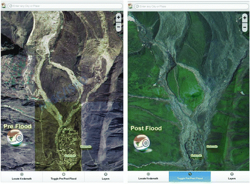
Figure 4 Kedarnath settlement before and after the flood. Note heavy damage and widening of channels in the northern part. (Source: http://bhuvan-noeda.nrsc.gov.in/projects/flood/)
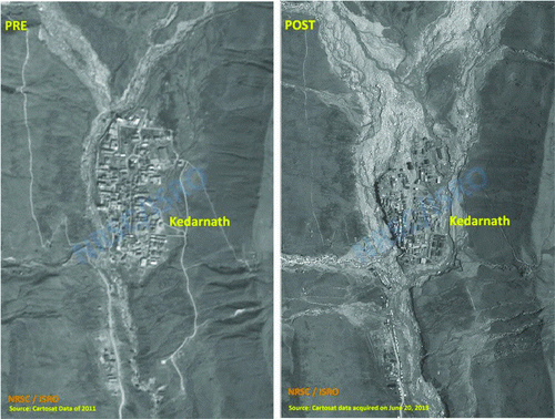
Figure 5 A pre- and post-image of region north of Kedarnath, showing heavy inflow with large amounts of silt. (Source: http://bhuvan-noeda.nrsc.gov.in/projects/flood/)
The second incidence of flash flooding occurred in the morning of 17 June 2013. It was more catastrophic. The main Mandakini stream was flooded, and in few seconds, it covered the entire Kedarnath settlement, destroying most of the buildings and partially damaging the temple (). Downstream, this flash flood destroyed several settlements killing thousands of pilgrims and local people, labourers, cattle, ponies and so on. The main townships washed away by the flash flood are Rambada, Gorikund, Sonprayag, Kund, Chandrapuri, Bhiri, Agastyamuni (Vijaynagar), Silli and Tilwada. Heavy damage was also caused to the townships further downstream, namely Rudraprayag, Srinagar, Kirtinagar, Devprayag and Rishikesh.
4. Cause of heavy destruction
The immediate cause of this heavy destruction has been due to extreme weather conditions. We elaborate more on the cause of heavy discharge and destruction through the following points:
| 1. | Exceptionally heavy snowfall in the ensuing winters: In the winters of 2013, there was exceptionally high snowfall. The winters of 2012–2013 (i.e. December 2012 to April 2013) rainfall received at Srinagar Garhwal was 220 mm. Although Srinagar town is about 65 km south of Kedarnath and Higher Himalayan ranges, the data clearly depicts that in the last nine years the mean precipitation in the region is about 55 mm but in the winters of 2012–2013 it was 220 mm, which is more than four times the average (). Figure 6 Rainfall record at Srinagar, about 65 km south of Kedarnath using data from India Meteorological Department. Two dashed lines denote the mean of the last nine years of rainfall in June and in winters 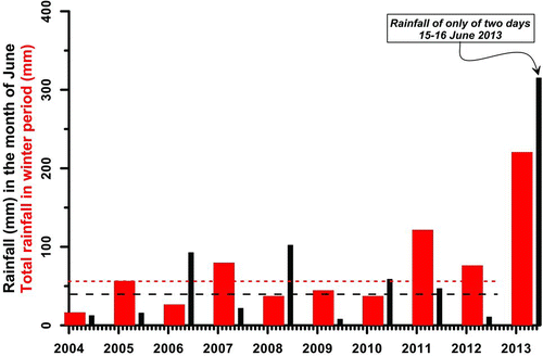 | ||||
| 2. | Two weeks advancement in summer monsoon: In general, the summer monsoon arrives in this region by the end of June or first week of July. But this year it arrived at least two weeks in advance. Besides this, the precipitation was exceptionally high because of the reasons discussed earlier. In two days, the precipitation was 315 mm, several times higher than the total rainfall in the month of June in past years (). The sudden and very high rain caused massive melting of the snow that would have been gradual otherwise. The high rainfall added with snowmelt water brought an enormous volume of water and debris in the rivers. | ||||
| 3. | The snout of Mandakini River is at Chaurabari Glacier, and at the downstream end of this glacier is Chaurabari Lake, whose catchment was about 4 km2 with a possible depth of 15 m. The sudden filling of this lake and its sudden outburst possibly added to the fury to the floods. | ||||
| 4. | Heavy rainfall also caused landslides along the slopes of the rivers that increased the destructive power of the floods. | ||||
| 5. | Kedarnath topography: Although the damage was extensive in the Uttarakhand, it was more severe in the Kedarnath region. The topography of the region of the Kedarnath settlement may be blamed for it. Unlike the topography of the other three “Dhams”, namely Badrinath, Yamunotri and Gangotri, where most of the settlement is on a slope of the valley, more than 10 m above the river bed, Kedarnath settlement is between two streams of Mandakini and is almost at the same level as that of the river bed (). Thus, the almost flat topography of the Kedarnath settlement did not provide any hindrance to the flood that caused extensive damage. Moreover, amongst all the other three Dhams, Kedarnath is located closest (only ∼4 km) to the snout from where the Mandakini River originates ( and ). | ||||
5. Natural calamity or a manmade disaster
We agree that the heavy rainfall at an unusual time was the main reason for this event. However, the question here is whether careless human intervention made it a disaster. Here, we present our views based on observations along the Mandakini–Alaknanda Valley. Our observations suggest that inadequate consideration of geology geomorphology and fragile ecology in expanding the urban clusters including Kedarnath, construction of several hydropower projects simultaneously, improper road alignment with poor construction, inadequate consideration of slope stability and faulty engineering techniques were major factors responsible for the recent fury of the flash floods. Experts hold the view that while tampering with the Himalayan slopes, one needs to be more careful as the slopes that have evolved by exogenic and endogenic processes are precariously balanced (Sati et al. Citation2011). It would be unjust to say that our planners and policy makers are not aware of the sensitivity of the Himalayan ranges, but it seems that the awareness is masked by the pressure of utilizing the Himalayan resources for national growth and providing easy and fast accessibility by developing road networks. Studies suggest that construction of a huge number of hydropower projects may also be a main cause of future disasters in the region (Rana et al. Citation2007). Our present surveillance indicates that hydropower projects that are under construction played a major role in magnifying the magnitude of disasters in the lower reaches of the valleys as they carelessly disposed of muck in the valleys which was produced by these hydroprojects, increasing size and destroying capacity of the flooding considerably. In a tentative estimate made by us, the 330 MW Srinagar hydropower project alone produced about 800,000 m3 of debris and muck. About 500,000 m3 of the muck was scraped during the present flood event, causing huge damage to the lower settlements in Srinagar Town. The flood level has been recorded at Srinagar as 11 m above the normal value, which is an all time high in the recorded history of the floods in the Alaknanda valley. Huge piles of sediment (about 20 m) are deposited in these settlements. About 70 schemes of hydropower are in different phases of execution on different rivers. These projects might have generated not less than 3 billion m3 of muck that is mostly dumped in the river banks, creating serious hazards in this region. Besides this, in construction of these projects heavy explosives have been used that have caused fractures in the rocks and overlying loose materials. These fractures facilitated the rainwater to go inside, causing landslides. With the excess rainfall, some of the surroundings have become more vulnerable for future landslides and are a threat for the people living in the regions.
6. Lessons learnt
| 1. | Poor response of relief: It is considered that the first two days of relief and rescue are crucial after a natural calamity before it becomes a disaster. Coordinated efforts were lacking, otherwise one could have saved several lives. In this case, the damaged region was very well defined and demarcated, and it will be difficult to imagine the scenario if a major or great earthquake strikes the region. In that case the damage will be widespread and even greater coordination will be required. It is important to involve local people in the relief operations after training them and use the local facilities for relief and rehabilitation. | ||||
| 2. | Road network is important for relief. Most of the road alignments in the hill areas are made with old engineering means, causing massive landslides during heavy rains. As a result of these landslides, roads were blocked during disasters, causing hindrance during rescue and relief operation. Thus, the emphasis should be given on better roads in the mountainous region using modern, safe and green technology. In the meantime, alternate means of transportation such as helicopters and ropeways should also be strengthened. | ||||
| 3. | The toll of the disaster is high due to poor and unplanned construction work at the most vulnerable sites. In last few decades, most of the settlement colonies, business set-ups and government structures have developed in low-lying areas, sometimes in the floodplains of the rivers. Besides this, most of the rain-fed streams are blocked by newly constructed buildings in the valleys. It is, therefore, recommended that an urbanization policy should be carefully formulated for the hills and construction and should be very regulated. It is important to consider the geology of the terrain, slope stability, and geomorphology and drainage system before planning for the construction in the area. | ||||
| 4. | Despite repeated and more or less similar flash flooding and landslide disasters in the past in several hilly regions of Uttarakhand, no proper microzonation maps for the landslide, floods and earthquake hazards are available. Thus, efforts should be made to prepare such maps and increase the public awareness about the utility of such maps. Using modern Geographical Information System tools, it is easy to combine various information and evaluate vulnerable areas and future risks. Additionally, the disaster management system needs to be more prompt and effective. Considering the natural disaster vulnerability of the hills, the state should come up with a transparent well-coordinated and effective disaster management policy and set-up. | ||||
| 5. | Was it an extreme and rare event? We need to see whether similar calamities occurred historically at other places. Probably, the techniques of paleoseismology can help dig out such past events in several parts of the Himalayan region. | ||||
| 6. | There seems to be uncontrolled, unplanned enormous growth of towns in the hilly regions as people are shifting from rural to urban settlements. For example, population growth rate of Rudraprayag district during 1981–1991, 1991–2001 and 2001–2011 is 17.4%, 13.7% and 6.5%, respectively. Although growth rate in Rudraprayag is low in the last decade, it is still significant. In other major cities, e.g., Dehradun, it is alarmingly high at 32.3%. Growth rate is also leading to over exploitation of natural resources in that region. It is necessary to check and define the maximum permissible size of the town in the hilly region. | ||||
| 7. | After adopting the Public Private Partnership policy, a large number of hydroelectric power projects have been initiated in the region. The implementing agencies (mostly private companies) do not hesitate in violating environmental rules for their benefit and as these rules are not very well defined, there is no strict implementation. The magnitude of the flood fury considerably increased because of these activities. Therefore, there is an urgent need to thoroughly review the hydropower policy of the state. | ||||
| 8. | Better management at Dhams: It appears that there is no record of how many people actually visit these pilgrimages. It is important to maintain the inflow and outflow records of people and vehicles to keep an account in case of a similar disaster. | ||||
References
- Ader , T , Avouac , J-P , Liu-Zeng , J , Lyon-Caen , H , Bollinger , L , Galetzka , J , Genrich , J , Thomas , M , Chanard , K Sapkota , S N . 2012 . Convergence rate across the Nepal Himalaya and interseismic coupling on the main Himalayan thrust: implications for seismic hazard . J Geophys Res , 117 : B04403 10.1029/2011JB009071 doi: 10.1029/2011JB009071
- Avouac , J-P . 2003 . Mountain building, erosion and the seismic cycle in the Nepal Himalaya . Adv Geophys , 46 : 1 – 79 . doi: 10.1016/S0065-2687(03)46001-9
- Bilham , R , Larson , K and Freymuller , J . 1997 . GPS measurements of present-day convergence across the Nepal Himalaya . Nature , 386 : 61 – 64 . doi: 10.1038/386061a0
- Gahalaut , V K . 2008 . Major and great earthquakes and seismic gaps in the Himalayan Arc, an invited review paper . Geol Soc India , 66 : 373 – 394 .
- Gahalaut , V K and Chander , R . 1997 . On interseismic elevation changes and strain accumulation for great thrust earthquakes in the Nepal Himalaya . Geophys Res Lett , 24 : 1011 – 1014 . doi: 10.1029/97GL00810
- Gaurav , K , Sinha , R and Panda , P K . 2011 . The Indus flood of 2010 in Pakistan: a perspective analysis using remote sensing data . Nat Hazards , 59 : 1815 – 1826 . doi: 10.1007/s11069-011-9869-6
- Joshi , V and Kumar , K . 2006 . Extreme rainfall events and associated natural hazards in Alaknanda valley, Indian Himalayan region . J Mt Sci , 3 : 228 – 236 . doi: 10.1007/s11629-006-0228-0
- Jouanne , F , Mugnier , J , Pandey , M , Gamond , J , Le Fort , P , Serrurier , L , Vigny , C and Avouac , J-P . 1999 . Oblique convergence in the Himalayas of western Nepal deduced from preliminary results of GPS measurements . Geophys Res Lett , 26 : 1933 – 1936 . doi: 10.1029/1999GL900416
- Prasad , A K and Singh , R P . 2005 . Extreme rainfall event of July 25–27, 2005 over Mumbai, West Coast, India . J Indian Soc Remote Sens , 33 : 365 – 370 . doi: 10.1007/BF02990007
- Rana , N , Sati , S P , Sundriyal , Y P , Doval , M M and Juyal , N . 2007 . Socio-economic and environmental implications of the hydroelectric projects in Uttarakhand Himalaya, India . J Mt Sci , 4 : 344 – 353 . doi: 10.1007/s11629-007-0344-5
- Sati , S P , Sundriyal , Y P , Rana , N and Dangwal , S . 2011 . Recent landslides in Uttarakhand: nature's fury or human folly . Curr Sci , 100 : 1617 – 1620 .
- Seeber , L and Gornitz , V . 1983 . River profiles along the Himalayan arc as indicators of active tectonics . Tectonophysics , 92 : 335 – 367 . doi: 10.1016/0040-1951(83)90201-9
- Valdiya , K S . 2010 . The making of India: geodynamic evolution , 816 New Delhi : Macmillan .
- Webster , P J , Toma , V E and Kim , H-M . 2011 . Were the 2010 Pakistan floods predictable? . Geophys Res Lett , 38 : L04806 10.1029/2010GL046346 doi: 10.1029/2010GL046346