
Abstract
In this paper, among multi-criteria models for complex decision-making and multiple-attribute models for assigning the most preferable choice, the technique for order preference by similarity ideal solution (TOPSIS) is implied. The main objective of this research is to identify potential natural hazards in Bandar Abbas city, Iran, using TOPSIS model, which is based on an analytical hierarchy process structure. A set of 12 relevant geomorphologic parameters, including earthquake frequency, distance from the earthquake epicentre, number of faults, flood, talus creep, landslide, land subsidence, tide, hurricane and tidal wave, dust storms with external source, wind erosion and sea level fluctuations are considered to quantify inputs of the model. The outputs of this study indicate that one region, among three assessed regions, has the maximum potential occurrence of natural hazards, while it has been urbanized at a greater rate compared to other regions. Furthermore, based on Delphi method, the earthquake frequency and the landslide are the most and the least dangerous phenomena, respectively.
1. Introduction
The World Vulnerability Report has shown a range of 50 different indicators for vulnerability. Among them are some natural hazards including geological and meteorological events such as earthquakes, floods, cyclones, droughts, windstorms, hailstorms, landslides, bushfires and tsunamis (Taubenböck et al. Citation2006). As complex spatial phenomena, they vary greatly in magnitude and frequency and result in death or injury to human beings, damage to the built environment and socioeconomic activities, and broadly speaking, even ecosystem (Chen et al. Citation2003).
Furthermore, the morphology of cities is strongly affected by features and the way these environmental hazards threaten urban areas, so that an efficient urban planning is supposed to play a key role in reducing their potential destructive effects. This includes identifying minimal-risk positions, where human activities could be safely established. Following this purpose, finding an efficient method has been always considered by researchers. Due to various natural hazards together with a variety of different complex effects, which are spatially and temporally distributed, a model to be able to simultaneously integrate and analyse a wide range of information is required. Rashed and Weeks (Citation2003) believe that “urban vulnerability to natural hazards such as earthquakes is a function of human behaviour. It describes the degree to which socioeconomic systems and physical assets in urban areas are either susceptible or resilient to the impact of natural hazards”.
As this paper is aimed to identify the most vulnerable local region to the impact ofnatural hazards and due to the variety of recognized potential hazards, a multi-criteria decision-making (MCDM) model is selected. Utilizing this approach, the analytic hierarchy process (AHP) and the technique for order preference by similarity to ideal solution (TOPSIS) are selected as well. The former is applied to develop a decision-making tree and the latter to search for the ultimate result.
The MCDM models are known as useful tools to evaluate and identify areas with the least risk. They refer to finding the best opinion from all of the feasible alternatives in the presence of multiple, usually conflicting, decision criteria. Priority-based, outranking, distance-based and mixed methods could be considered as the primary classes of the current methods (Torfi et al. Citation2010). The surveys show that these models are mostly used for tackling land suitability problems such as natural hazards (Malczewski Citation2006). Besides, the AHP method has been widely used in MCDM, which implies a number of successful applications of this method (Saaty Citation1988). Another known classical MCDM method, TOPSIS was first developed by Hwang and Yoon (Citation1981) for solving a MCDM problem. This method is theoretically based on choosing the best alternative, which has the shortest distance from the positive-ideal alternative and the longest distance from the negative-ideal alternative (Hwang & Yoon Citation1981). Similarly, TOPSIS method has been widely applied in solving MCDM problems for evaluating airlines’ service quality. For instance, Tsaur et al. (Citation2002) used AHP method to calculate the criteria weights and used TOPSIS method to determine the alternatives’ ranking for evaluation of airline service quality. Feng and Wang (Citation2000) utilized TOPSIS method for evaluating the performance of different airlines. Gumus (Citation2009) evaluated dangerous waste transport companies using hierarchical structure and fuzzy logic with the TOPSIS model. Kun-peng and Zhi-jie (Citation2009) believed that the assessment of emergency management ability is difficult to quantify in crisp number. Moreover, not only were the expert's scores often vague, but it was also hard to collect the data of disasters.
Considering these facts, the paper applies the interval-valued fuzzy TOPSIS method to solve the problem with MCDM characteristics. Abo-sinna and Amer (Citation2005) extended TOPSIS approach to solve multi-objective large-scale nonlinear programming problems. Chen et al. (Citation2001) introduced a multi-criteria evaluation (MCE) and geographic information systems (GIS) programme called MCE-RISK for risk-based decision-making. The programme incorporated different MCE-GIS methods including weighted linear combination and TOPSIS. They utilized the programme to prioritize a given area based on danger of bushfire. Kaur et al. (Citation2009) explored the feasibility of using TOPSIS to identify small areas of similar land use in a given region in India. The study concludes that a decision, on the basis of TOPSIS, could be reached to select where further investigation could be made, or the approach should be applied for extracting more than one feature. Spatial risk management of natural hazards using MCE-based methods is now being probed at.
Jing (Citation2010) employed TOPSIS to develop an optimization model of city fire station sites in China. Jahanshahloo et al. (Citation2006) extended TOPSIS method to introduce an algorithm for determining the most preferable choice among all possible choices when data is interval. Finally, an example is shown at the end of this paper to highlight the procedure of the proposed algorithm.
Human's existing knowledge about hazard phenomena and the processes that drive them are imperfect. It is, therefore, necessary to develop appropriate models (process, spatial and temporal) to improve scientific society's findings and empirical evidences. The synthesis of data and the mapping of the relationships between the hazard phenomena and the elements at risk require the use of models (Zerger Citation2002). In this study, a decision-making tree is structured via the AHP method. Afterwards, TOPSIS modelling is applied to prioritize urban areas vulnerability to intensity of natural hazards in Bandar Abbas, southern city in Iran.
2. Study-area description
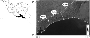
Bandar Abbas, a port city founded in 1623, is located in the north of Hormuz Strait in Persian Gulf, Iran. The city is crucially important for political and economic reasons. In terms of geographic coordinates, it lies between the 56°9′16″ and 56°24′59″ E (longitude) and 27°8′5″ and 27°16′19″ N (latitude), like a straight coastal line. The city is divided municipally into three regions, i.e. Region 1, Region 2 and Region 3 (). The annual precipitation in this area is 210.6 mm; relative humidity is 65.6%; the minimum and the maximum annual temperatures on averages are 21.8 and 32.1 °C, respectively. It also has desert climate, according to Koppen classification. The geological structure of the area is often made of quaternary sediments that include Sadich (conglomerate) and Minab (fine silt and sand) formations.
Figure 1. The study area location in Iran and the three region positions (IRS-1D-Pan, July 2002).
3. Methodological framework
There are three fundamental facts in the study area.
A wide range of natural hazards in Bandar Abbas is locally recognized.
The impacts of the hazards differ from each other.
Various risks are spatially and temporally distributed in the area due to diverse hazards.
A framework, according to which the study is carried out, is depicted stepwise in the following:
Step 1. Create a decision-making tree applying AHP structure.
Step 2. Identify required criteria, then make calculations and quantify them.
Step 3. Assign the relative weights for the criteria based on expert's opinions.
Step 4. Build a decision-making matrix.
Step 5. Evaluate the decision-making matrix in the six stages according to TOPSIS model:
Step 1. Compute the dimensionless matrix.
Step 2. Create the diameter matrix.
Step 3. Create the weighted dimensionless matrix.
Step 4. Calculate the positive and negative ideal.
Step 5. Calculate the distance from positive and negative ideal.
Step 6. Calculate the relative closeness to the ideal solution and rank the performance order.
4. Results
4.1. Create a decision-making tree
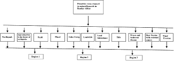
The decision-making tree is constructed in three levels according to AHP (). As it is defined in the first level, the study is aimed to assess three municipal regions, which are more likely to be vulnerable to 12 natural hazard factors. Then, 12 risk factors, namely: earthquake frequency, distance from the earthquake epicentre, fault frequency, flood, talus creep, landslide, land subsidence, tide, waves, dust storm, wind erosion and sea level fluctuations are selected based on geomorphic parameters to be implied for the second stage. As it has been illustrated in as well, the city is divided into three major regions according to hydrological units to make the results more applicable for urban management purposes. Following this definition, the third level involved in Region 1, Region 2 and Region 3.
Figure 2. The designed analytical hierarchical structure (AHP).
4.2. Calculation of the matrix elements
Table 1. Experience of an earthquake in Bandar Abbas city.
The 12 risk factors, which are considered before, are described in the following:
Earthquake frequency.
Only are earthquakes, which occurred with the distance of less than 50 km from the centre of city, collected from information resources since 400 years ago to be given in . Besides, the table excludes information about earthquakes with intensity less than 3.5° in the scale of surface waves (Richter) (Building and Housing Research Centre Citation1993, Citation1994).
Table 2. Calculation of flood flow rate.
Distance from the earthquake epicentre.
In every region, the linear distances between earthquake epicentres and region's geographical centre are estimated and added together. Consequently, a cumulative number is obtained for each region. Then these numbers are weighted using a bipolar method, according to which the more the distance from the epicentre, the fewer the score given. The scores are from 1 to 9 by means of which the method can encode qualitative information to quantitative ones.
Flood.
The peak discharge of the greatest observed flood in every three regions is estimated via the US Soil Conservation Service method. Through algebraic multiplying cross section of river by the run-off height, value of discharge was obtained ().
Table 3. Decision-making matrix.
Talus creep.
Due to the development of the city to the north, there is a danger of talus creeps for some sloped areas near the mountains. To employ this factor to the model, the areas which are potentially exposed to talus creep are recognized upon field surveys. Then the total length of all the recognized areas is figured out in each region.
Landslide.
Considering the fact that landslide has direct relation with land slope, a good indicator to express the impact of landslide on decision-making process can be obtained from multiplying the percentage of land slope by the amount of area for each region that is finally divided by summation of three regions’ area.
The number of fault.
The number of existing faults in each region is counted without any considerations to the depth and the size of the faults.
Land subsidence.
Frail coastal sediments along with the mixture of soil and water can cause land subsidence. This phenomenon is often seen in either constructed part (structure) or enclosed area (yard) of buildings. To quantify this factor to be adapted to the model, the following steps can be done.
A specimen of 25 houses with the age of more than 10 years is considered in each region.
All subsidence, which were at least 1-cm and 5-mm deep in the yard and structure, respectively, are estimated.
The algebraic summation of the land subsidence is calculated separately in every region.
The tide.
A set of five particular points in every region is determined to measure the horizontal move of tide over every 24-hour period. The collected data within 15 days is finally averaged out.
Hurricane and tidal wave.
To quantitatively assess the impact of this disaster, the data of wave height, which are collected from Hormozgan Meteorology Organization, are weighted according to bipolar method.
Dust storms with external source.
Investigations by environmental studies provide strong evidence that dust storms generally originate from neighbouring countries. Moreover, facts and figures from Bandar Abbas weather station show that both the number of dusty days and the relative concentration are practically similar in all regions.
Wind erosion.
A wide range of local winds which in turn cause serious soil erosion (typically called wind erosion) has been reported along with the information about the amount of moved soil in every region.
Sea level fluctuations.
The forward and the retreat of the Persian Gulf, which change over long geological periods, are defined based on marine terraces. To do so in this study, a number of collected images from IRS-P6-Liss (IV) and IRS-1D-Pan are modified with field observations considering marine terraces level, which are located at eastern and western borders of Bandar Abbas. Then sea level on the digital elevation model is changed through the global mapper software. The achieved results demonstrate that changes of terraces level are in conformity with the horizontal tide changes. Therefore, score of forward and retreat of the sea is the same as the score of tide.
All the 12 explained factors, which are assessed so far, along with further details are given in .
Table 4. Relative weight of parameters.
4.3. Decision-making on initial judgments
Considering the fact that urban natural hazards are not equally important, a method by means of which the recognized factors can be weighted is required. Following this purpose, Delphi method is applied, so that a questionnaire is prepared and a group of experts to answer that. The panel of experts includes academic member of universities in civil, natural resources, water resources, meteorology fields and some managers of organization relative to natural hazards. illustrates the average weight of each factor. These factors are applied after formation of weighted dimensionless matrix and are considered as the matrix modulator.
Table 5. Dimensionless matrix.
4.4. Decision-making matrix
Displayed in , a matrix with 3 rows (for 3 regions) and 12 columns (for 12 natural hazards) is built according to decision-making tree. It is clear that the possibility of comparison among items with different units is one of the advantages of TOPSIS model (Rao Citation2007).
Table 6. Value of Pij and ln(Pij).
4.5. Performance of TOPSIS model
Step 1. Compute the dimensionless matrix
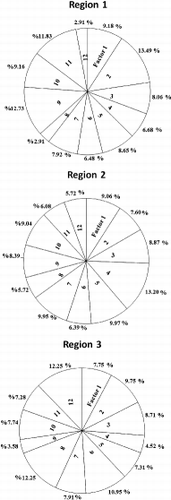
To compare these 12 risk factors, a dimensionless matrix, which is given in , was calculated based on equation (1) (Thomas Citation1990),
(1) where rij denotes decision-making matrix member, i is the representative of three regions and j refers to 12 effective parameters and Nij is dimensionless matrix. The 12 natural hazards distribution in every region is shown in .
Figure 3. The distribution of 12 natural hazards in every region.
Step 2. Create the diameter matrix.
For creating a diameter matrix, an entropy method, which provides a criterion for evaluating factors’ weights via a discrete probability distribution, is applied. Therefore, equations (2)–(6) are calculated, and then the diameter matrix is obtained (),
where K (confidence coefficient) is equal to inversed logarithm of options’ number (three regions) thus, k = 0.91; Dj is distrust (deviation); Wj is the weight which is calculated through equation (5) and Tj presents the relative weights of 12 criteria which were determined using the judgments of DM (). W′j is adjusted weight for diameter matrix. The values of Pij and ln(pij ) are shown in and also the values of Ej, Dj, Wj and W′j are expressed in .Figure 4. Diameter matrix.
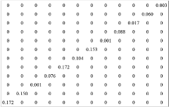
Table 7. The value of Ej, Dj, Wj, Tj and Wj′.
Table 8. Weighted dimensionless matrix.
Step 3. Create the weighted dimensionless matrix
In , a weighted dimensionless matrix is obtained from multiplication diameter matrix in dimensionless matrix in the first step as is visible in equation(7),
where Vij denotes the weighted dimensionless matrix, this matrix constituted the basis of analysis and comparisons in three regions. The role of 12 factors in decision-making can be determined by analysis of this matrix.Table 9. Determining (A−) and (A +).
Step 4. Calculate the positive and negative ideal.
Positive ideal (A+) and negative ideal (A−) are shown in and are calculated as below:
Table 10. The values of (di−) and (di+).
Table 11. The values of cli+ and its ranking.
Step 5. Calculate the distance from the positive and negative ideal.
The separations of positive and negative ideal (di+, di−) are calculated through equations (10) and (11). These values have been displayed in .
Step 6. Calculate relative closeness to the ideal solution and rank the performance order.
With regard to the definition of (cli+) index (equation (11)), relative closeness to the ideal solution was calculated, and then ranking of the options is identified in an ascending order (). Thus, the smallest number (0.0903) is related to
5. Discussion
According to the attained results from this study, three given regions can be sorted in ascending order (cli+) as Region 3, Region 2 and Region 1.The lowest index (cl3+ = 0.0903) for Region 3 indicates that there is the highest level of occurrence of natural hazards. On the other hand, Region 1 with the highest index has the lowest potential occurrence of natural hazards. Eventually, having the value of 0.2117 for
, Region 2 stands between the other two regions from an urban vulnerability point of view. In other words, Region 3 is anticipated to experience natural disasters 2.9 times more than Region 1 and 2.3 times than Region 2.
In terms of evaluation of the relative importance of the recognized natural hazardous factors, Delphi method reveals that earthquake frequency and landslide are the most and the least dangerous phenomena, respectively. Following earthquake frequency is distance from the earthquake epicentre, flood, the number of fault, land subsidence, dust storms with external source, wind erosion, talus creep, the tide and hurricane and tidal wave, in decreasing order of potential risk.
To express the advantages as well as differences in this study, a limited range of existing studies which are partly similar to this paper is aimed to be discussed in this section. For instance, Rashed and Weeks (Citation2003) assessed urban vulnerability to natural hazards such as earthquakes via fuzzy logic. They used AHP method to generate a set of fuzzy weights for the evaluation criteria. The results suggested that the proposed methodology may provide a new approach for analysing vulnerability that can add to our understanding of human/hazards interaction. However, compared to the research, which has employed a single-criterion decision-making approach, we developed a multi-criteria method with 12 natural hazards. Moreover, a combination of both TOPSIS and AHP has been devised for prioritizing.
Gharakhlou et al. (Citation2010) studied different physical and semi-physical patterns for increasing access to different districts in a city through applying changes to the present network of routes. Thus, the patterns and indices were extracted by means of AHP method and these patterns were, then, analysed and ranked through TOPSIS, FUZZY and simple additive weighting (SAW), respectively, from MCDM techniques. Next, the results were combined by means of Borda method. A comparison between this research and our work indicates that they introduced a method to deal with urgent conditions after natural disasters, while we targeted a preventive design to minimize the potential consequences.
Elaalem et al. (Citation2010) compared two land-evaluation techniques fuzzy-AHP and TOPSIS for a test area within Jeffara Plain of Libya. The model revealed that the percentages of land units, which ranked as highly suitable and less suitable classes for barley, are very small. Apart from a quite similarity between the employed techniques in both studies, ours resulted in prioritization of urban areas, but theirs was aimed to land evaluation.
Moradi et al. (Citation2012) employed AHP technique to produce the landslide susceptibility map in Dena city in Iran. For this purpose, eight layers including landslide inventory, raining, lithology weathering, earthquake, slope, land cover, distance to stream and distance to road were considered. The susceptibility map was compared with 150 active landslides and demonstrated that the active landslide zones had a high correlation to the high and very high susceptibility class of map. As it is clear, not only we improved our proposed technique by implementation of TOPSIS, but also a wider range of potential hazards has been considered, which in turn makes the final results more reliable.
6. Conclusion
In this paper, a new approach to TOPSIS method application has been heuristically developed in combination with AHP technique to deal with the problem of evaluating and prioritizing urban areas according to natural hazards.
First, a decision-making tree has been constructed in three levels via AHP whose first level is used to define the aim of study as the assessment of three municipal regions, which are more likely to be vulnerable to 12 natural hazard factors. Then, a set of 12 risk factors has been selected. Accordingly, the third level involved in Region 1, Region 2 and Region 3. After calculating, measuring and quantifying 12 factors, the relative weights for every 12 criteria were specified based on Delphi method. In the next step, by applying TOPSIS model, urban areas vulnerability to intensity of natural hazards was sorted. The initial results of Delphi method reveal that earthquake frequency and landslide are the most and the least dangerous phenomena, respectively. Ultimately, the study exposes that there is the highest level of occurrence of natural hazards in Region 3, while Region 1 has the lowest potential occurrence of natural hazards and Region 2 stands between them.
However, despite the fact that Region 3 has the highest level of threat from the natural disasters, it is developing at the faster rate compared to the other regions with lower risk. This development is making the most dangerous region to be the most heavily urbanized one as well, which in turn necessitates an urgent managerial action against these growing serious conflicting aspects of Region 3. Otherwise, the residential and urbanized areas in this region are likely to experience some environmental calamities in the future as a result of any of the recognized natural disasters happening with unexpected tragic consequences. For instance, establishing an airport, finding some air force military facilities, planning densely populated residential and commercial areas along with many high-investment businesses, etc, are among the developments which have wrongly undertaken in this region.
Acknowledgements
The authors sincerely thank the editor and the anonymous referees for their helpful comments and suggestions, which lead to essential improvements in composition and presentation of the paper.
Related Research Data
References
- Abo-Sinna MA, Amer AH. 2005. Extensions of TOPSIS for multi-objective large-scale nonlinear programming problems. Appl Math Comput. 162:243–256.
- [BHRC] Building and Housing Research Center. 1993. The earthquake 7 March 1974 in Bandar Abbas, Report no. 172. 1st ed. Tehran: Building and Housing Research Center. Persian.
- [BHRC] Building and Housing Research Center. 1994. The earthquake 21 March 1976 in Bandar Abbas, Report no. 174. 1st ed. Tehran: Building and Housing Research Center. Persian.
- Chen K, Blong R, Jacobson C. 2001. MCE-RISK: integrating multi criteria evaluation and GIS for risk decision-making in natural hazards. Environ Modeling Software,. 16:387–397.
- Chen K, Blong R, Jacobson C. 2003. Towards an integrated approach to natural hazards risk assessment using GIS: with reference to bushfire. Environ Manag. 31:546–560.
- Elaalem M, Comber A, Fisher P. 2010. Land evaluation techniques comparing fuzzy AHP with TOPSIS methods. Proceedings of the 13th AGILE International Conference on Geographic Information Science; 11–14 May; Portugal: 1–8.
- Feng CM, Wang RT. 2000. Performance evaluation for airlines including the consideration of financial ratios. J Air Transp Manag. 6:133–142.
- Gharakhlou M, Faraji Sabokbar HA, Givehchi S. 2010. Access enhancement by making changes in the route network to facilitate rescue operations in urban disasters. Int J Environ Res. 4:183–192.
- Gumus AT. 2009. Evaluation of hazardous waste transportation firms by using a step fuzzy, AHP and TOPSIS methodology. Expert Syst Appl J. 36:4067–4074.
- Hormozgan Organization of Management and Planning. 2005. Hormozgan book (geography, history, Persian Gulf and province neighborhoods) Hormozgan: Hormozgan Organization of Management and Planning. Persian.
- Hwang CL, Yoon K. 1981. Multiple attribute decision making—methods and applications. Heidelberg: Springer Verlag.
- Iran University of Science and Technology. 1999. Project of studying of collection- translation and storage of surface waters in Bandar Abbas. Report no. 1. Tehran: Iran University of Science and Technology. Persian.
- Jahanshahloo GR, Hosseinzadeh F, Izadikhah M. 2006. An algorithmic method to extend TOPSIS for decision-making problems with interval data. Appl Math Comput. 175:1375–1384.
- Jing XI. 2010. Optimization model of city fire station sites based on entropy weight TOPSIS. Fire Sci Technol. 5:1–15.
- Kaur P, Sharma R, Mahanti NC, Singh AK. 2009. Exploration of TOPSIS (technique for order preference by similarity to ideal solution) as an alternative to traditional classification algorithm in small areas of Lohardaga District of Jharkhand, India, using remote sensing image-A case study. Res J Earth Sci. 1:81–85.
- Kun-peng J, Zhi-jie S. 2009. Assessment of disaster emergency management ability based on the interval-valued fuzzy TOPSIS method. Commun Comput Inf Sci. 35:501–506.
- Malczewski J. 2006. GIS-based multicriteria decision analysis: a survey of the literature. Int J Geogr Inf Sci. 20:703–726.
- Moradi M, Bazyar MH, Mohammadi Z. 2012. GIS-based landslide susceptibility mapping by AHP method, a case study, Dena City, Iran. J Basic Appl Sci Res. 2:6715–6723.
- Rao RV. 2007. Decision making in the manufacturing environment using graph theory and fuzzy multiple attribute decision making. London: Springer.
- Rashed T, Weeks J. 2003. Assessing vulnerability to earthquake hazards through spatial multicriteria analysis of urban areas. Int J Geogr Inf Sci. 17:547–576.
- Saaty TL. 1988. Multicriteria decision making: the analytic hierarchy process. Pittsburgh (PA): RWS Publications.
- Taubenböck H, Kemper T, Roth A, Voigt S. 2006. Assessing vulnerability in Istanbul: an example to support disaster management with remote sensing at DLR-ZKI. Proceedings of Fifth International Symposium German Turkish Joint Geodetic Days; 28–31 March;Berlin. 1–9.
- Thomas LS. 1990. Decision making for leaders. Pittsburgh (PA): RWS Publications.
- Torfi F, Zanjirani Farahani R, Rezapour S. 2010. Fuzzy AHP to determine the relative weights of evaluation criteria and Fuzzy TOPSIS to rank the alternatives. Appl Soft Comput. 10:520–528.
- Tsaur SH, Chang TY, Yen CH. 2002. The evaluation of airline service quality by fuzzy MCDM. Tourism Manag. 23:107–115.
- Zerger A. 2002. Examining GIS decision utility for natural hazard risk modeling. Environ Modeling Software,. 17:287–294.