
Abstract
Arsenic testing work has been carried out in Uttar Pradesh by UP Jal Nigam during the period 2005–2008. During this period, arsenic testing was performed using field test kits for 150,000 sources employing screening and blanket testing approach. The current paper describes the work of geographical information system (GIS) mapping in Bahraich district. The district has two physiographic units – Uprahar and Tarhar to depict highland and lowland Quarternary alluvial plains. Out of 30,216 India Mark II hand pumps in the district, arsenic testing was performed, by UP Jal Nigam for 13,812 hand pumps, out of which 7190 (52.06%) tested sources show arsenic value > 0 μg/L. Further segregation of data shows that 56.66% of affected sources fall in 10–40 μg/L category and 10.86% sources fall in >50 μg/L category. Village level mapping of affected sources at GIS platform shows arsenic concentration is more in Huzoorpur and Tajwapur blocks which lie in lowland physiographic unit.
1. Introduction
In recent years, arsenic contamination of water and groundwater has become a major concern at global scale (Mandal & Suzuki Citation2002). Sustained arsenic intake leads to chronic intoxication, and prolonged arsenic exposure can damage the central nervous system, liver, skin and results in the appearance of diverse types of cancer, such as hyperkeratosis, lung and skin cancer (Mohan & Pittman Citation2007). High concentrations of arsenic in drinking water can lead to arsenicosis, a condition that may include skin lesions, paralysis, blindness, bladder, lung, skin, kidney, liver and prostate cancers (Yamauchi & Fowler Citation1994).
Arsenic is naturally present in the geological formations, such as lacustrine sediments and volcanic rocks (Buddharatna & Dhoble Citation2011). In South and East Asia, an estimated 60 million people are at risk from high levels of naturally occurring arsenic in groundwater (World Bank Citation2005). Arsenic was first identified in the groundwater of West Bengal in 1983, following a medical diagnosis of arsenic poisoning (Saha Citation1984, Citation1995; Mazumdar et al. Citation1988). The problem of arsenic in Uttar Pradesh was first recognized in 2003 in District Ballia (CPCB Citation2007). In Uttar Pradesh during 2003–2004, the ground water of 12 districts were found to be contaminated with arsenic (Nickson et al. Citation2007).
Viewing the severity and its causes, an intensive database preparation for the integration of various components is necessary. Geographical information system (GIS) is a powerful tool for collecting, storing, retrieving at will, transforming and displaying spatial data from the real world (Burrough Citation1986). In 2008, UNICEF New York assigned the work to Peter Ravenscroft, a researcher at the University of Cambridge, to develop a GIS model to predict the global extent of arsenic contamination of groundwater, based on his previous work on the geology of arsenic contamination. The model predicted potential for occurrence of arsenic in groundwater and has correctly identified many areas where it is known to occur. The results also indicated several areas where arsenic in groundwater is not known, but based on this modelling, it can be suspected to find its occurrence (Arsenic Primer Citation2008).
2. Details of study area
District Bahraich has been chosen for the study because in this district maximum number of sources were tested for arsenic contamination in Uttar Pradesh and maximum number have also been identified with arsenic, beyond permissible category.
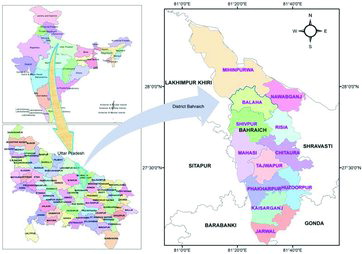
District Bahraich has an international border with Nepal on the northern part. District Barabanki and Sitapur are in south, Khiri in the west and Gonda and Shravasti in the east (). It is situated between the 28.24° and 27.4° latitude and 81.65°–81.3° eastern longitude. Bahraich has a geographical area of 4696.8 km2. It is a part of Ghagra basin which covers an area of 4,707,074 ha. From 21 districts having 206 blocks of Uttar Pradesh, district Bahraich comprises 12 blocks as lower administrative units.
Figure 1. Administrative boundary map of Bahraich.
As per provisional census of government of India (Provisional Census Records Citation2011), population of district Bahraich is 1,452,832, where 1,279,928 (88.09%) people reside in rural area and 172,904 (11.90%) of total district population people in urban areas.
Bahraich district has almost a flat topography with its gentle slope towards south. The regional topographic elevation in the north is 150 m above mean sea level (amsl), while in south it is 102 m. On an average the topographic gradient from north to south is 0.39 m/km. Physiographically the district area can be divided into uplands plain or the older Quaternary alluvium and the lowlands plain or the newer Quaternary alluvium. Locally, the uplands are known as Uparhar and lowlands are known as Tarhars.
The Uparhar comprises gently undulating high level plains, while the Tarhar comprises the low lying slightly undulating terrain eroded in recent times by Ghagra and Rapti rivers flowing in Uparhar.
The entire district of Bahraich is the part of Ghagra Alluvium Plain and is underlain by Quaternary Alluvium comprising mainly sand of various grades with clay and kankar and at places boulders and pebbles. This plain is formed by Ghagra river and its tributary Sharda in the north. The width of Ghagra plain varies 40 km from north and central regions to 10 km in south (Srivastava et al. Citation1994).
The alluvium in the area can be broadly classified into older alluvium and newer alluvium. The older alluvium is of Middle Pleistocene age and generally occupies high ground which is not affected by flood during the monsoon. The newer alluvium occupies lower latitudes and is mainly confined to the flood plains along the river channels and belongs to the upper Pleistocene to recent age (Krishnan Citation1960). In the north-eastern corner of the district, lies the Bhabar tract, followed by the Tarai which extends NNW–SSE direction parallel to the trend of Shivalik Hills. The Bhabar terai fringes enter into Nepal following almost the trend of Shivalik and are not found in the remaining northern and north-western part of the district.
Topography plays a vital role in the deposition of arsenic sediments. Topographic map was derived from processing of ASTER remote sensing images, considering geomorphology of the Bahraich district as described by Central Ground Water Board. The topographic level varies from 180 to 100 amsl from north to south, and thus gets delineated in two geomorphic units ().
Figure 2. Topography of the district Bahraich.
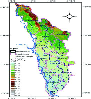
An overlay analysis with topographic data derived from CitationASTER, along with arsenic-affected Gram Panchayats, revealed that arsenic severity is more in flat terrain, while it is less in high terrain. Evidence from Argentina suggests that highest ground water are found in small topographic depressions where seasonal discharge occurs (Smedley et al. Citation2002). The same is true in Mongolia and also true in case of Bangladesh (Smedley et al. Citation2003).
3. Previous work
Initially, Jadavpur University came out with a report on arsenic contamination in drinking water sources in Ballia and Lakhimpur districts in 2005. The study was supported by UNICEF. After this study, UP Jal Nigam performed testing in all habitations of Ballia and Lakhimpur districts.
From the analysis of this data it was realized that arsenic is geogenic in nature and was found in younger alluvium. Further, 289 blocks of 49 additional districts were identified which lie along river Ganga and Ghagra. Arsenic testing was performed in the years 2005 and 2006 for about 110,000 sources. In the identified blocks of 49 districts, screening/blanket tests were performed by field test kit (FTK) method.
The test results showed that arsenic above 50 μg/L (safe limit set by BIS, GoI) was found in 18 districts and in the range of 10 μg/L (safe limit set by WHO) was found in 31 districts including 18 (Nickson et al. Citation2007). More testing was carried out in 2007 and 2008. Blanket testing was performed for about 40,000 sources of five districts, i.e. Bahraich, Gorakhpur, Ghazipur, Chandauli and Bareilly, where >50 μg/L arsenic concentration was higher as compared to other districts.
In some districts, database was also generated along with other attributes, like date of collection, depth of hand pump bored and the installation year. The areas where FTK response was more than 50 μg/L were tested again for confirmatory testing in the laboratories of UP Jal Nigam. Comparative results indicated almost same values of arsenic ranges.
Block level data was compiled in GIS format at State Water Resources Agency (Sinha Citation2011), which assisted in creation of various aspects of arsenic coverage, including quantum and spatial distribution along the Ghagra and Ganga river basin in Uttar Pradesh. Earlier, in Ballia, Ghazipur and Varanasi districts, GIS-based mapping was performed (Shekhar & Shekhar Citation2012).
Here, a description has been given for the preparation of arsenic database at Gram Panchayat level in GIS format and its subsequent spatial analysis.
4. Arsenic testing data collection and its analysis
FTK initially developed by National Chemical Laboratory Pune, manufactured in India by Chem-In Corporation, Pune, named as CFTK was used extensively and then Wagtech Digital Arsenator (WFTK) was used for confirmatory testing mainly for the sample in which arsenic concentration was found to be more than 40 μg/L for Screening and Blanket Testing. WFTK is based on the Gutzeit reaction in which arsenic species reacts with sodium borohydride in the presence of sulphamic acid. WFTK detection limit is 2–500 μg/L, and test can be performed within 20 minutes. The WFTK uses a detector to detect colour and this has improved instrument sensitivity, reproducibility and detection limit (Kinniburgh & Kosmus Citation2002). An evaluation study carried out mainly for performance evaluation of Wagtech Arsenator was performed by Shriram Institute of Industrial Research, New Delhi and confirmed excellent technical efficiency in detection of arsenic 94.3% (SRRI Citation2006).
FTK method was used for arsenic testing considering the reliability of data and ease of collection for a mass scale set of data. The benefits include on-site data for project evaluation, saving of time and remobilization costs (Wright et al. Citation1995). Test kits are relatively inexpensive, portable and effective for indicating the presence of arsenic and have many advantages over analytical laboratories (Steinmaus et al. Citation2006). Their main limitation is that many chemical reactions in raw water samples may be masked by other reactions (by other ions) occurring in the same solution. Second, the FTK are subject to fluctuations in sensitivity and accuracy depending on the model (Petrusevski et al. Citation2007). CFTK and WFTK, which were used in Bahraich, were also used in Ballia and Kanpur and it was found that WFTK correctly classified 85% of the tested wells, while CFTK was slightly lower in accuracy, as it correctly classified only 80% of the well (Sankararamakrishnan et al. Citation2008). FTK currently are being used to classify tube wells as delivering arsenic below 50 μg/L (the recommended limit in developing countries) as safe, painted green or above 50 μg/L, unsafe and painted red (Rahman et al. Citation2002).
The issue of water quality monitoring and surveillance has been given due emphasis in India by the Ministry of Drinking Water and Sanitation under the National Rural Drinking Water Programme (NRDWP). The monitoring and surveillance results from the habitations are also to be put on the database of the Department and monitored to ensure drinking water safety at the household level. The National Rural Water Quality Monitoring and Surveillance Programme launched in February 2005 has now been merged with NRDWP and also emphasized that existing FTK may continue to be used for primary detection of chemical and biological contamination of all the drinking water sources in the villages (NRDWP Citation2010). However need was emphasized for further evaluation of the screening results by the FTK, prior to its recommendation for wide scale use in Bangladesh and elsewhere in the world (Jakaria et al. Citation2007).
Screen and blanket testing was carried out in Bahraich district in 2007. In blocks of the district with >10%, sources with >50 μg/L, all public sources were then tested. In case blocks that had <10% affected sources but habitation had >10% affected sources, blanket test was performed for all sources in that habitation (Srivastava & Tripathi Citation2006; Nickson et al. Citation2007). shows the status of arsenic testing in India Mark II hand pumps in all blocks of Bahraich. Depth of hand pumps in Bahraich varies from 70 to 120 m; therefore, testing was done for the groundwater coming from that level. also shows the status of 13,812 India Mark II hand pumps that have been tested in the district by UP Jal Nigam. Maximum hand pumps have been tested in Tajwapur block where 86.09% of the total available India Mark II hand pumps have been tested, which constitutes 9.9% of total installed hand pumps of the district. The least number of tested hand pumps was from Balha block where only 1.27% hand pumps were tested against the total hand pumps available in that block. It is also important to note that Belha has 9.12% of total installed India Mark II hand pump in the whole district, up to year 2011.
Table 1. Status of hand pump and tested hand pump in district Bahraich.
A vision document for mitigation and remedy of groundwater in arsenic menace in India has designed a road map for diagnostic survey of the arsenic vulnerable areas and preparing thematic map on GIS environs showing arsenic affected, vulnerable and freshwater zone have been suggested (Ghosh Citation2010). Using this approach in this study, use of GIS application extent of arsenic severity mapping has been attempted. All data up to source level/habitation level/village level and Gram Panchayat level have been linked with digital GIS layers at Gram Panchayat level and delineation of severity in terms of range distribution in the district.
shows that total testing was performed in 522 villages of 274 Gram Panchayats in Bahraich district. Out of 13,812 India Mark II hand pumps tested, 45.71% were found to be affected with arsenic contamination. From the table, it is evident that in five blocks, sampling was done for less than 10% of total installed hand pumps, while in some blocks, blanket testing approach was followed.
Table 2. Arsenic test result, ranges and affected gram panchayats.
At village level, GIS layers were intersected with arsenic-affected Gram Panchayats to find a spatial pattern of tested samples in Bahraich. Two distinct thematic maps were generated; one to present arsenic distribution in the district and another to present range distribution of quantified arsenic ranges. Maps, thus prepared, show that almost all blocks are affected by arsenic. In Shivpur, Tajwapur, Phakharpur and Huzoopoor blocks, maximum hand pumps are affected by arsenic contamination.
Correlation of data from and shows that in Mahsi 72.65%, in Kaisarganj 37.27% and in Jarwal 19.31% sources are found to be affected; however, the level of hand pumps chosen for testing is only up to a maximum of 7.88%. It is also important to note that geomorphologically these blocks have higher arsenic contamination as these blocks lie on flat terrain.
Figure 3. Arsenic-affected village in Bahraich.
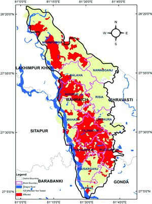
On compilation of complete arsenic tested database and visualizing it in GIS format, it can be interpreted that in Tajwapur, Phakharpur and Huzoorpur blocks, most of the hand pumps are contaminated with arsenic but simultaneously it is noteworthy that more than 75% hand pump sources of total installed were tested in these blocks. also shows that except for Phakharpur in which 46% hand pump sources are arsenic contaminated, in Tajwapur and Huzoorpur, 60% hand pumps are contaminated by arsenic.
shows that Phakharpur and Tajwapur block population is more prone for ingestion of >50 μg/L arsenic-contaminated drinking water which is 12.59% and 17.42%, respectively.
Because of the proven and widespread negative health effects on humans, in 1993 the WHO lowered the health-based provisional guideline for a “safe” limit for Arsenic concentration in drinking water from 50 to 10 μg/L. The WHO retained this provisional guideline level in the latest edition of its standards (WHO Citation1993, Citation2004). This warranted deeper analysis of different ranges of Arsenic which has been shown in . Increased risk of lung and bladder cancer and of arsenic-associated skin lesions have been reported to be associated with ingestion of drinking water concentration >50 μg/L (Idris Citation2006) so assessing distribution of this concentration is necessary.
Figure 4. Categorization of arsenic ranges in Bahraich district.
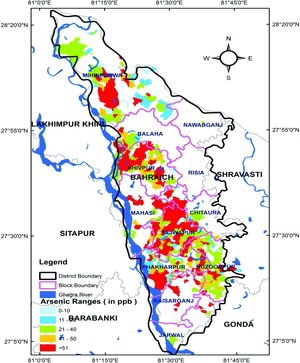
From the analysis of arsenic range distribution in Bahraich, from and and , it is evident that out of the total 45.71% tested hand pumps 52.06% hand pumps are affected by arsenic. Of these, maximum sources are within the permissible range of 10–40 μg/L, which account for 56.66% of total arsenic-affected hand pumps and 10.86% are in more than 50 μg/L range, especially in those blocks where screening testing has been done and number of tested villages as well as hand pump sources are substantially lower.
GIS-based arsenic categorization shows that worst arsenic-rich hand pump sources are found in depression zone and low lying topography. GIS approach may be useful further in the application of arsenic mitigation technologies in the contaminated areas by viewing the higher concentration of arsenic.
On the basis of generated information, UP Jal Nigam has done preventive measure in the worst affected blocks by installation of arsenic removal unit (ARU). Further, on the basis of these FTK-based generated data and results of indicative test performed, Japan International Cooperation Agency (JICA) has also launched Bahraich Arsenic Mitigation Project (BAMP) in Tajwapur block (Yano et al. Citation2012).
5. Conclusion
In Huzoorpur, Mihipurwa, Phakharpur, Shivpur and Tajwapur blocks, blanket testing was done and maximum arsenic concentration was observed in Huzoorpur and Tajwapur blocks which fall in lowland topographic unit of Tarhar. Analysis of GIS map shows high probability of arsenic concentration in Kaisarganj and Jarwal blocks; these are blocks where only 6.53% and 7.86% sources have been tested. By adopting blanket approach in these blocks, newer villages and Gram Panchayats with arsenic concentration would be identified.
Arsenic testing was performed in 274 gram panchayats. These gram panchayats cover 522 villages. Therefore, the spatial information available from GIS maps will be helpful to provide considerable public health benefit.
Learning from the field indicates that FTK have their own problems and government-supported laboratories need to be strengthened. However, the use of FTK and H2S vials cannot be ignored as they not only serve the purpose of initial screening of contamination, but also are an effective tool for awareness generation amongst the community to consume only safe drinking water and maintain.
Acknowledgements
Authors are thankful to UP Jal Nigam and UNICEF in providing the data for analysis. Thanks are also due for the field level officials of UPJN who collected the FTK data of arsenic contamination. Authors are also grateful to Dr Aidan Cronin, WASH Specialist, UNICEF, India for making valuable suggestions to improve the manuscript.
References
- Arsenic Primer. 2008. Guidance for UNICEF country offices on the investigation and mitigation of arsenic contamination. New York, NY: Water, Environment and Sanitation Section Programme Division, UNICEF.
- ASTER Global DEM. 2011. Available from: http://earthexplorer.usgs.gov
- Buddharatna JG, Dhoble RM. 2011. Removal of As (III) from groundwater by iron impregnated potato peels (IIPP): batch study. Int J Adv Eng Sci Technol. 7:54–64.
- Burrough PA. 1986. Principles of geographical information systems for land resources assessment. New York (NY): Oxford University Press.
- [CPCB] Central Pollution Control Board. 2007. Status of ground water quality in India. Part - I. Groundwater Quality Series: GWQS/09/2006. New Delhi: Ministry of Environment and Forests, Government of India.
- Ghosh NC. 2010. Mitigation and remedy of ground water arsenic menace in India: a vision document. New Delhi: National Institute of Hydrology, Roorkee and Central Ground Water Board; p. 143.
- Idris MZ. 2006. Arsenic in drinking water, health effect and management, a clinical diagnosis and treatment manual. Lucknow: Department of Community Medicine K.G.M.U, U.P. Jal Nigam, UNICEF, Uttar Pradesh.
- Jakaria MD, Vahter M, Rahman M, Waheed AM, Hore SK, Bhattacharya P, Jacks G, Persson LA. 2007. Screening of arsenic in tube well water with field test kits: evaluation of the method from public health perspective. Sci Total Environ. 379:167–175.
- Kinniburgh DG, Kosmus W. 2002. Arsenic contamination in groundwater: some analytical consideration. Talanta. 58:165–180.
- Krishnan MS. 1960. Stratigraphy of India and Burma. New Delhi: CBS Publication.
- Mandal BK, Suzuki KT. 2002. Arsenic round the world: a review. Talanta. 58:201–235.
- Mazumdar DNG, Chakraborty AK, Ghosh A, Gupta JD, Chakraborty DP, Dey SB, Chattopadhay N. 1988. Chronic arsenic toxicity from tubewell water in rural West Bengal. Bull World Health Org. 66:499–506.
- Mohan, D, Pittman CU. 2007. Arsenic removal from water/wastewater using absorbents: a critical review. J Hazard Mater. 142:1–53.
- [NRDWP] National Rural Drinking Water Programme. Framework for Implementation. 2010. New Delhi: Department of Drinking water Supply, Ministry of Rural Development, Government of India.
- Nickson RT, Sengupta C, Mitra P, Dave SN, Banerjee AK, Bhattacharya A, Basu S, Kakoti N, Moorthy NS, Wasuja M, et al. 2007. Current knowledge on the distribution of arsenic in groundwater in five states of India. J Environ Sci Health A. 42:1–12.
- Petrusevski B, Sharma S, Schippers JC, Shordt K. 2007. Arsenic in drinking water. The Thematic Overview Papers 17. Delft: IRC International Water and Sanitation Centre.
- Provisional Census Records. 2011. Ministry of Home Affairs, Government of India. Available from: http://censusindia.gov.in/2011-prov-results/indiaatglance.html
- Rahman MM, Mukherjee D, Sengupta, MK, Chwdhury KU, Lodh DC, Chitta R, Roy SS, Qumaruzzaman Q, Milton HA, Shahidullah MS, et al. 2002. Effectiveness and reliability of arsenic field testing kits: are the million dollar screening projects effective or not? Environ Sci Technol. 36:5385–5394.
- Saha KC. 1984. Melanokeratosis from arsenic contaminated of tube well water. Indian J Dermatol. 29:37–46.
- Saha KC. 1995. Chronic arsenical dermatosis from tubewell water in West Bengal during 1983–87. Indian J Dermatol. 40:1–12.
- Sankararamakrishnan N, Chauhan D, Nickson RT, Tripathi RM, Iynengar L. 2008. Evaluation of two commercial kits used for screening of groundwater for arsenic in northern India. Sci Total Environ. 401:162–167.
- Shekhar M, Shekhar L. 2012. Application of information technology and computer programming in arsenic mapping. Int J Soft Comput Engg. 2:541–547.
- Sinha RS. 2011. Arsenic toxicity in ground water of Uttar Pradesh: an overview of the problem with mapping of arsenic hotspots using GIS application. Technical Report GWE/1/2011.
- Smedley PL, Niccoli HB, Macdonald D, Baron AJ, Tullio JO 2002. Hydro-geochemistry of arsenic and other inorganic constituents in ground water from La Pampa Argentina. Appl Geochem. 17:259–284.
- Smedley PL, Zhang M, Luo Z. 2003. Hydro-geochemistry of the Fluviao-lacustrine aquifers and arsenic mobilisation in the Huhhot Basin. Inner Mongolia Appl Geochem. 18:1453–1477.
- Srivastava AK, Tripathi RM. 2006. Arsenic in ground water in Uttar Pradesh: testing and mitigation activities. In: Proceedings of 1st International Symposium on Health Hazards of Arsenic Contamination of Groundwater and its Countermeasures. Miyazaki (Japan): University of Miyazaki; p. 77–82.
- Srivastava P, Prakash B, Sehgal JL, Kumar S. 1994. Role of neotectonic and climate in development of Holocene Geomorphology and soils of the Gangetic Plains between, the Ramganga and Rapti Rivers. Sedimentary Geol. 94:129–151.
- SRRI. 2006. Evaluation of water quality monitoring and purification products under long term agreement, performance evaluation of Wagtech Arsentor. New Delhi: Shriram Institute of Industrial Research.
- Steinmaus CM, George CM, Kalman DA, Smith AH. 2006. Evaluation of two new arsenic field test kits capable of detecting Arsenic water concentration close to 10 μg/L. Environ Sci Technol. 40:3362–3366.
- [WHO] World Health Organisation. 1993. Guidelines for drinking-water quality. Recommendations. 2nd ed. Geneva: World Health Organisation.
- [WHO] World Health Organisation. 2004. Guidelines for drinking water quality. Recommendations. 3rd ed. Switzerland: World Health Organisation. Available from: http://www.who.int/water_sanitation_health/dwq/gdwq3/en/
- World Bank. 2005. Towards more effective operational responses arsenic contamination of ground water in South and East Asian countries. Report no. 31303. The World Bank Environmental and Social Unit South Asia Region Water and Sanitation Program WSP South and East Asia; p. 24–25.
- Wright KA, Jermstad, David B. 1995. Evaluation of a rapid field analytical test kit for assessing hydrocarbon soil contamination. Paper presented at: Third International Conference On-Site Analysis; Houston, TX.
- Yamauchi H, Fowler BA. 1994. Toxicity and metabolism of inorganic and methylated arsenicals. In: Nriagu JO, editor. Arsenic in the environment, Part II. Cycling and characterization. Wiley Series in Advances in Environmental Science and Technology. New York (NY): Wiley- Interscience; p. 293.
- Yano Y, Ito K, Kodama A, Shiomori K, Tomomatsu S, Mitsuhiro S, Hiroshi Y. 2012. Arsenic polluted groundwater and its countermeasures in the middle basin of the Ganges, Uttar Pradesh State, India. J Environ Prot. 3:856–862.