
Abstract
On 3 August 2014, an earthquake of Mw 6.5 happened in Ludian County, Yunnan Province, China. This earthquake triggered hundreds of landslides of various types, dominated by shallow slides, deep-seated slides, rock falls, debris flow and unstable slopes. Using field investigations and remote sensing images, 413 landslides triggered by the Ludian earthquake were statistically analyzed. Statistical analyses show that most of the landslides are shallow slides with a small volume. Most of these landslides are concentrated near the epicentre with distances ranging from 6–12 km, especially at the upper slope along the river valley. The number of landslides increased with increasing distance from the epicentre (0–9 km) and then decreased with increasing distance from the epicentre (>9 km). The landslides decreased in density with increasing distance from the fault rupture. More than 70% of the landslides occurred on the right side of the Xiyuhe-Zhaotong fault, when viewed from Southwest (SW) to Northeast (NE). Slope aspect and gradient had a substantial influence on the landslide distribution and landslide density increased with increasing slope gradient. Approximately, 65% of the landslides happened at the back slope with respect to the earthquake epicentre.
1. Introduction
Landslides are a complex natural hazard in many countries, especially in mountainous areas; broad areas can be intensely affected by landslides triggered by large earthquakes (Cruden & Varnes Citation1996; Zhou et al. Citation2013). Landslides play a major role in the evolution of landforms and also impact the future development trend of the regional geological hazard in the earthquake-affected area. In recent years, earthquake-triggered landslides have received increasing attention from researchers in several fields, such as spatial distribution analysis, hazard assessment and landslide mitigation of the earthquake-affected areas (Hungr et al. Citation2001).
Earthquake-triggered landslides can result in serious economic losses and casualties. For example, landslides triggered by the 2004 Mid Niigta prefecture earthquake occurred within the Niigata Prefecture (central Japan), causing severe damage, isolating villages in the mountainous areas near the epicentre, and taking six lives (Chigira & Yagi Citation2006). The 2007 Niigata Chuetsu-Oki earthquake (Mw 6.6) caused 11 fatalities, nearly 2000 injuries and damaged approximately 1100 residences (Collins et al. Citation2012). The 2002 Avaj earthquake caused 233 fatalities and injured approximately 1500 (Mahdavifar et al. Citation2006). Landslides triggered by these events provide direct empirical evidence for the spatial distribution of landslides (Chigira & Yagi Citation2006).
Previous research results for the spatial distribution of earthquake-triggered landslides are important for understanding what areas may be susceptible to landslides in future earthquakes (Dai et al. Citation2011). Statistical analysis for 11,000 landslides triggered by the 1994 Northridge earthquake (Mw 6.7) shows that the most common types of landslides were highly disrupted shallow falls and slides of rock or debris (Harp & Jibson Citation1996). Keefer (Citation2000) mapped 1280 landslides triggered by the 1989 Loma Prieta earthquake (Mw 6.9) and noted that the hazard level of earthquake-triggered landslides might be better correlated with the lithological characteristics rather than the geotechnical parameters. Correlations between landslide seismological, geomorphologic, geological and spatial distribution parameters can be used for seismic landslide hazard assessment, prevention and mitigation (Jibson et al. Citation2000; Chigira et al. Citation2003).
On 3 August 2014 (at 16:30), a Mw 6.5 earthquake happened in Ludian County (E103º19 30, N27º05 13), Zhaotong City, Yunnan Province, China. Immediately after this event, we arrived at the earthquake area to carry out field investigations of geomorphologic conditions, geological properties and earthquake-triggered landslides. In this paper, landslide classification and spatial distribution characteristics are presented first. Then, the distributions of earthquake-triggered landslides influenced by the geological and geomorphologic conditions in the earthquake-affected area are discussed, especially for the slope aspect and gradient. Some useful conclusions are presented for understanding the spatial distribution characteristics of earthquake-triggered landslides.
2. Regional setting and earthquake characteristics
In this section, a brief introduction for the Mw 6.5 Ludian earthquake is presented first. Then the geomorphologic, geologic and climatic conditions of the study area are introduced. Finally, the disaster characteristics of the landslide triggered by the Mw 6.5 Ludian earthquake are analyzed.
2.1. The Mw 6.5 Ludian earthquake
Ludian County is located in the north-west part of Yunnan Province, with a longitude of 103º09–103º40 and a latitude of 26º59–27º32. Ludian County is approximately 27 km away from Zhaotong City and 310 km away from Kunming City (Kuang et al. Citation2014). The total area of Ludian County is approximately 1487 km2, of which 87.9% is mountainous (approximately 1305.45 km2). The history earthquake records within 200 km of the earthquake epicentre show that 15 strong earthquakes (Mw > 6.0) happened in this area since 1900. The largest one was the Daguan earthquake (Mw 7.1). Ludian County is located within an earthquake-prone zone, having historically experienced several periods of earthquakes. In recent 10 years, the occurrence of moderate/strong earthquake is increased obviously in this region and the nearby region, such as the 2003 Mw 5.1 Ludian earthquake, 2004 Mw 5.6 Ludian earthquake, 2006 Mw 5.1 Yanjin earthquake and 2012 Mw 5.7 and Mw 5.6 Yiliang earthquakes (Li et al. Citation2014). Previous research results show that the area of co-seismic landslide (related with the landslide density) is increased with the increasing of earthquake magnitude, and exhibit a nonlinear relationship (Keefer Citation1984). In the study area, a similar correlation is existed between the landslide density and earthquake magnitude, but with an approximate linear relationship (Xu et al. Citation2014a).
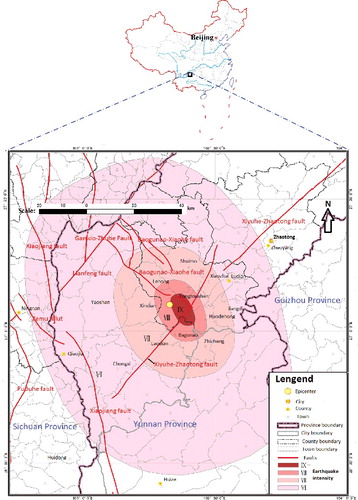
On 3 August 2014 (at 16:30), an Mw 6.5 earthquake happened in Ludian County (E103º19′30″, N27º05′13″), Zhaotong City, Yunnan Province, China (Jin et al. Citation2014). The epicentre of the Ludian earthquake was near the Xiyuhe-Zhaotong fault, with a focal mechanism of strike-slip rupture and a focal depth of approximately 12 km. shows the location of the Mw 6.5 Ludian earthquake and the affected area from this earthquake. Ludian County and Qiaojia County were the most seriously affected areas by this earthquake. Statistical data collected before 15:00 on 8 August 2014 show that the Mw 6.5 Ludian earthquake caused 617 deaths; in addition, 112 people went missing, 3143 peoples were injured and 80,900 houses collapsed (Kuang et al. Citation2014). As shown in , the most seriously affected areas, those with a seismic intensity of IX degree, included Longtoushan town, Huodehong town and Shuimo town in Ludian County and Baogunao town in Qiaojia County. Another region located at the eastern side from the epicentre within the range of 3 to 15 km had a seismic intensity of IX degree. The affected areas with the seismic intensity of VIII degree, which is located within the range of 2–12 km from the epicentre, had a total area of approximately 290.76 km2. Most landslides happened in these two regions, especially in the seriously affected areas.
Figure 1. Intensity map of the Mw 6.5 Ludian earthquake on 3 August, 2014 published by the China Earthquake Administration.
Source: (Modified) http://www.cea.gov.cn/publish/dizhenj/464/478/20140807085249557322083/index.html.
2.2. Geomorphology
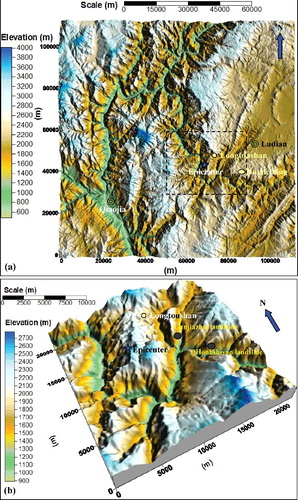
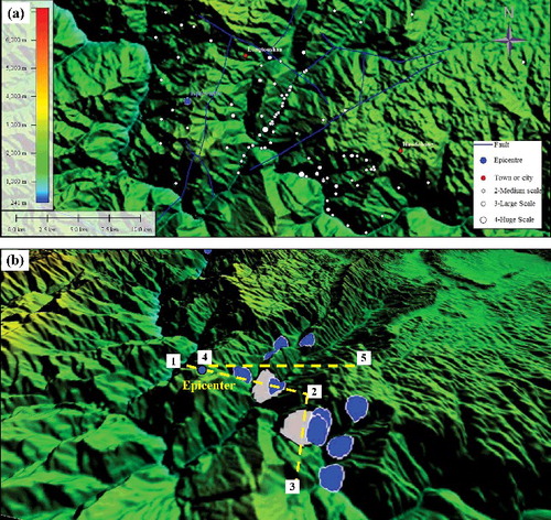
Ludian County is located in the north-west region of the Yunnan-Guizhou Plateau, south of Yunnan plateau. This region includes one river (Niulanjiang River), two mountains (Wumengshan Mountain and Wulianfeng Mountain), three streams (Longshu, Shaba and Zhaolu), and two alpine plains (Wentao and Longshu). Terrain in both the east and the west is relatively high and the middle part is flat; the landforms in this area are complex and include deeply incised mountains, karst plateaus, mixing plateaus, plateaus from a lacustrine basin, rift valley plains and other geomorphic units (Hu et al. Citation2007). shows the three-dimensional (3D) visualization of the study area. In the seriously affected area of the Ludian earthquake, more than 76% of the regional area has a slope gradient larger than 15º and 46% of the area has a slope gradient larger than 25º. This region has experienced intense tectonic movements and seismic activity is frequent. Furthermore there are several active faults throughout this region (Li et al. Citation2014). As a result of the effect of intense erosion by the Niulanjiang River and other tributaries, this area has developed canyon terrain, deep narrow valleys and steep slopes, providing favourable terrain conditions for the geological disasters during the earthquake process.
Figure 2. Three-dimensional visualization of the study area: (a) Ludian County and Qiaojia County and (b) seriously affected areas of the Ludian earthquake.
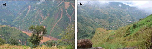
Due to the humid climate, abundant rain falls in the region and most of the slopes are covered with dense vegetation. shows images for the affected area of the Ludian earthquake. This area has a varied terrain condition ((a)), the slope gradient is large and dense vegetation covers the steep slopes ((b)). However, under the effects of strong earthquakes or heavy rainfall, landslides or debris flows often happen in this region, resulting in some slopes being covered by sparse vegetation or exposed bedrock.
Figure 3. Images for the affected area of the Ludian earthquake: (a) varied terrain condition and (b) dense vegetation-covered slopes.
2.3. Geological condition
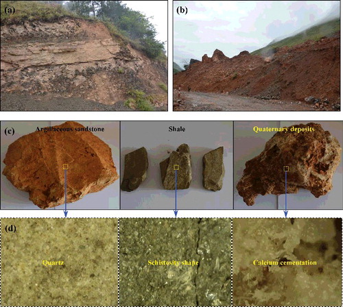
The strata in Ludian County is relatively completely exposed in outcrop, ranging from upper Sinian to Quaternary (the domain strata is Paleozoic); however, lower Silurian, Jurassic, Cretaceous do not appear in this region (Hu et al. Citation2007). shows the sketch map for the main strata distribution in Ludian County. As shown in , the main types of rock mass are basalt, limestone, sandstone, dolomite and shale. During the long geological history, the ancient geographical environment has always changed, and the rock types and their mutual combination relations have a certain change in space. Limestone is mainly distributed in the eastern area of the Carboniferous hill area. Sandstone and shale are mainly distributed in the south-west region of the river valley (Kuang et al. Citation2014). Layered sedimentary rocks have widespread exposure in the shallow locations of study area ((a)). Under the influence of tectonic activity, faults, folds and joints are well developed in this area, and the shallow rock mass is fractured. Furthermore, there are large volumes of quaternary deposits that have accumulated at the lower slope ((b)) during the long geologic history of active faulting activities, with different material compositions and degrees of cementation ((d)). Landslides will easily happen during strong earthquakes or intense rainfall conditions. Three images of typical rock samples (argillaceous sandstone, shale and quaternary deposits) are shown in (c) and the micro-structural characteristics of these three rock samples are shown in (d).
Figure 4. Sketch map for the main strata distribution at the Ludian County.
Source: (Modified) Original public shared geological map from the geological data information cluster sharing service platform in China; http://dzzl.mlr.gov.cn/datagateway/index.action.
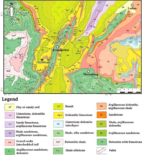
Figure 5. Typical lithology condition and rock masses within the affected area of the Ludian earthquake: (a) sedimentary layered rock masses; (b) quaternary deposits accumulated at the lower slope; (c) three typical rock masses: argillaceous sandstone, shale and quaternary deposits and (d) micro-structural characteristics of these three rock masses.
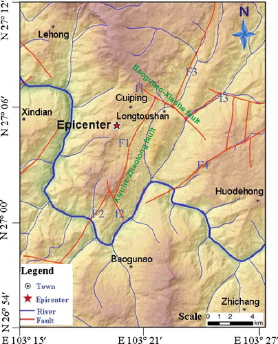
The main geological structure trends to the north-west throughout most of the region (Jin et al. Citation2014). The dip angle of the north–south fault is generally steep, with a large vertical offset. shows the spatial distribution map of the active faults and the epicentre of the Mw 6.5 Ludian earthquake on 3 August 2014. There are two main fault groups in the Ludian earthquake region, the main fault group is the Xiyuhe-Zhaotong fault, which includes four branch faults: F1, F2, F3 and F4 (Li et al. Citation2014). Another fault group is nearly vertical to the Xiyuhe-Zhaotong fault, the Baogunao-Xiaohe fault, which includes three branch faults: f1, f2 and f3. The Ludian earthquake happened near the Xiyuhe-Zhaotong fault (Xu et al. Citation2014a). Because large amounts of seismic energy were released from the fault deformation during the earthquake process, several different scales of landslides formed in this area.
Figure 6. Spatial distribution map of the active faults and epicenter of the Mw 6.5 Ludian earthquake on 3 August 2014.
2.4. Climate
The altitude of Ludian is approximately 568–3356 m, belonging to the low latitude mountain monsoon climate region, with an annual average temperature of 12.1 ºC and an average annual rainfall of 924 mm. The highest temperature occurs in July, with a maximum temperature of 31.3 ºC and an average temperature of 20.1 ºC. Most of the rainfalls is concentrated from May to September (rainy season), the average annual maximum hourly rainfall is approximately 35.0–65.0 mm, and the average annual maximum daily rainfall is approximately 83.0–120.0 mm (Jin et al. Citation2014).
Regarding the landslide disasters in the affected area of the Ludian earthquake, the magnitude of this earthquake was relatively strong (Mw 6.5). The geomorphology of the affected area is a typical alpine valley landform, the slope rock masses are strongly weathered and unloading, and huge volumes of quaternary deposits have accumulated at the lower slope. Therefore, this earthquake caused many landslides during the earthquake process. Furthermore, this time period time is within the rainy season, so that debris flows were triggered several times after the earthquake. In this paper, debris flows are regarded as one type of landslide and are also counted during the field investigation of the landslide disasters.
3. Landslides type and statistical analysis
In this section, the type of landslide triggered by the Ludian earthquake is presented based on field investigations and remote sensing images. When the landslide volume is larger than 10 × 104 m3, these landslide events are extracted from the remote sensing images; and those landslide events with small scale are determined by field investigations. Two giant landslides triggered by the Ludian earthquake are introduced. Spatial distribution characteristics of the landslides triggered by the Ludian earthquake are analyzed by statistical analysis.
3.1. Type of landslides
The landslides triggered by the Ludian earthquake can be classified into four broad types: (a) slides (shallow slides and deep-seated slides); (b) rock falls; (c) debris flows; and (d) unstable slopes (slopes have large deformation or obvious failure phenomenon, but a landslide has not happened). Slides and rock falls on steep natural slopes were the majority of landslide disasters during the Ludian earthquake. They posed a huge threat to structures and human beings at the lower slope. shows the typical landslide disasters in the affected areas of the Ludian earthquake. As shown in (a), the shallow slide stripped off the dense vegetation that covered the steep slopes, allowing detection from the remote sensing images. Shallow slides mainly happened in the quaternary deposits or in the strongly weathered/unloading layer. The shallow slides triggered by the Ludian earthquake were most widely spread in Huodehong and Longtoushan towns, especially along the Ludian-Qiaojia road ((c)).
Figure 7. Typical landslide disasters in the affected area of the Ludian earthquake: (a) shallow slides in Huodehong town; (b) and (c) are deep-seated slides and shallow slides in the Zhaotong-Qiaojia road; and (d) and (e) are deep-seated slides in Longtoushan town.
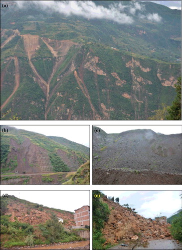
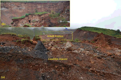
Deep-seated slides triggered by the earthquake were far less numerous than shallow slides. Deep-seated slides typically occurred along joints or in the weak interlayer ((b)), and tensile fracture surfaces were always formed during the earthquake process. As shown in (d) and (e), a deep-seated slide happened at the Xiaobojing slope in Longtoushan Town, which is located in the strongly weathered rock mass layer. Field investigation results show that only 17 of the mapped landslides had volumes in excess of 100 × 104 m3. Three of them, the Hongshiyan, Wangjiapo and Ganjiazhai landslides, were catastrophic and resulted in huge losses of life and property. Some shallow failures or deep-seated slides could be described as rock falls, most of these happened in the steep rock mass slope.
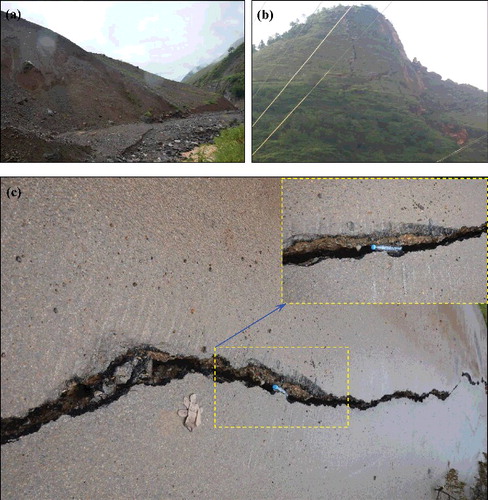
Huge volumes of loose landslide deposits were accumulated in the lower slopes of mountainous gullies after the earthquake, which provided abundant source materials for the initiation of debris flows during the following rainfall season. Several debris flow events appeared in the earthquake-affected area ((a)). shows the other landslide types in the affected area of the Ludian earthquake. In addition to the slides and rock falls, unstable slopes are another important type of landslide. Under the action of seismic forces from the Ludian earthquake, some steep slopes were fractured. Although landslides did not directly result, this unstable slope posed potential risks for the structures and human beings at the lower slope. Most of these had rather small displacements, forming only small cracks or fractures. There were numerous steep slopes that exhibited tensile fracture surfaces after the Ludian earthquake ((b)). Some roadbeds were fractured or showed subsidence ((c)), resulting in cut off roads or relocation of residents.
Figure 8. Other landslide types in the affected area of the Ludian earthquake: (a) debris flow in loose landslide deposits, (b) tensile failure of a slope and (c) fracture of a roadbed.
3.2. Two giant landslides
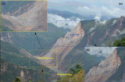
The Hongshiyan landslide is a typical landslide of the rock fall type. It is located downstream of the Honhshiyan reservoir (distance approximately 600 m). shows the Hongshiyan giant landslide triggered by the Ludian earthquake. This slope is located at the left bank of Niulanjiang River, with a steep gradient larger than 1.0. The main type of rock mass is limestone. During the earthquake process, a landslide is initiated at the upper slope, with a vertical tensile fracture at the tail of slope ((a)). The landslide was initiated with a volume of 1200 × 104 m3 and then travelled down the steep slope. Most of the landslide deposits rushed into the Niulanjiang River ((b)) and caused the blockage of the river. This formed a landslide dam with a length approximately 1000 m (from upstream to downstream). The elevation of the dam top is 1216 m, and the reservoir capacity of the dammed lake is approximately 2.6 × 10⁹ m3 ((c)). Until 18:00 of 5 August, the water flow at the upstream end was approximately 197 m3/s and the discharge at the downstream end was approximately 80 m3/s. The reservoir volume is approximately 4.96 × 10⁷ m3. The water depth at the upstream increased sharply with rate of 0.16 m/h, and rose to the elevation of 1176 m until 14:00 of 6 August. The Hongshiyan landslide was a typical geological disaster chain of events in the mountainous area during the earthquake process, with a large-volume landslide transforming to a dammed lake. Although the Hongshiyan landslide did not directly cause loss of human life or property, it has posed a large threat to downstream areas.
Figure 9. The Hongshiyan giant landslide triggered by the Ludian earthquake: (a) full view of Hongshiyan landslide, (b) image of the landslide initiation zone and (c) the Niulanjiang River was blocked by the landslide deposits.
The Ganjiazhai landslide is a typical landslide of the deep-seated slide type. It is located at the middle section of Zhaotong-Qiaojia road. shows the Ganjiazhai giant landslide triggered by the Ludian earthquake. The Ganjiazhai slope is a typical old landslide deposit slope, with different cementation degrees of the quaternary deposits ((a)). During the earthquake process, a landslide was initiated at the upper part of the slope, and a clear tensile fracture existed at the tail of the landslide ((b)). The landslide suddenly slid down to the lower slope with a volume of approximately 1600–1700 × 104 m3. Unfortunately, a small village is seated at the middle of the landslide travel path. This catastrophic landslide was the largest one among all of the landslides triggered by the Ludian earthquake and caused huge losses of life and property. Thirty-two houses, 20 cars and 55 people were buried in this landslide; 49 people are still missing.
Figure 10. The Ganjiazhai giant landslide triggered by the Ludian earthquake: (a) full view of a Hongshiyan landslide and (b) tensile fracture at the tail of a landslide.
3.3. Spatial distribution analysis
Prior to the earthquake, many different scales of landslides were widely distributed in the region affected by the Ludian earthquake. These landslides were mainly triggered by heavy rainfall or manmade disturbances. shows the spatial distribution of landslides in the affected area before the Ludian earthquake. As shown in (a), most of these landslides were located at the lower slope in quaternary deposit layers and along the river valley. Two hundred and forty-nine landslides were detected in the study area before the 2014 Ludian earthquake. The main type was a slide in quaternary deposit layers, with a total of 63%. Rock fall was the second most common landslide type, with a total of 27% ((b)). shows the definitions for landslide sizes by volume. Small-scale landslides have volumes less than 10 × 104 m3. Giant scale landslides have volumes larger than 500 × 104 m3. Moderate and large-scale landslides have volumes of 10–100 × 104 m3 and 100–500 × 104 m3, respectively. As shown in (c), most of the landslides are small and moderate scale, with a total of 96%. The lower slopes and valleys show the highest landslide densities because the quaternary deposits mostly accumulate in these areas.
Figure 11. Spatial distribution of landslides in the affected area before the Ludian earthquake: (a) spatial distribution, (b) proportion of different landslide types and (c) proportion of different landslide scales.
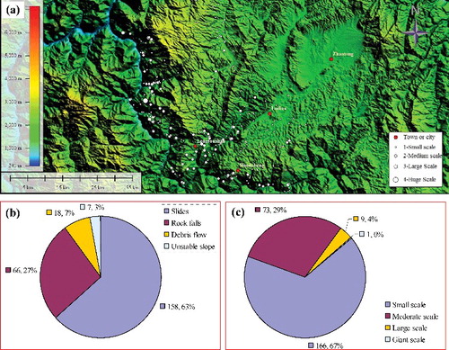
Table 1. Definition for the size of landslide by volume.
On 3 August 2014, numerous landslides were triggered by the Mw 6.5 Ludian earthquake. shows the spatial distribution of landslides in the affected area after the Ludian earthquake. Four hundred and thirteen landslides were detected within the area affected by the Ludian earthquake from field investigations and remote sensing images. As shown in (a) and (b), most of these landslides were concentrated near the epicentre, especially at the upper slope along the river valley. The main types of landslides were slides and rock falls in quaternary deposit layers or strongly weathered rock masses, with a total of 83% ((c)). For the 2004 Mid Niigta prefecture earthquake (Mw 6.8) in Japan, using remote sensing images and field investigations, Chigira and Yagi (Citation2006) found that more than 1000 landslides were triggered in the Miocene to Quaternary sedimentary rocks. The most common landslides were shallow slides on steep slopes, but more than 100 deep-seated landslides were triggered by this earthquake. For the 2013 Minxian and Zhangxian counties earthquake (Mw 6.6) in Gansu, China, Xu et al. (Citation2014b) found that small-scale soil falls, slides and topples were the main landslide types triggered by this earthquake, along with a few deep-seated landslides. The domain landslide type during earthquake process is the shallow side, which has been common in many previous disastrous earthquakes worldwide (Chigira & Yagi Citation2006; Mahdavifar et al. Citation2006; Collins et al. Citation2012).
Figure 12. Spatial distribution of landslides in the affected area after the Ludian earthquake: (a) spatial distribution, (b) proportion of different landslide types and (c) proportion of different landslide scales.
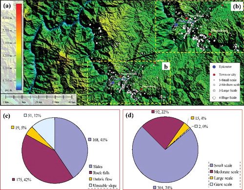
Earthquake-induced slope failures were influenced by the thickness of quaternary deposits and vegetation cover on the slope. Ground motion was another significant factor for the triggering of shallow slides. For the landslides triggered by the Mw 6.5 Ludian earthquake, as shown in (d), most of the landslides were small and moderate scale (landslide volume smaller than 100 × 104 m3) with a total of 96%. Small-scale shallow slides on steep slopes were the main type of landslide, only a few deep-seated landslides appeared in the earthquake-affected area. These deep-seated landslides, however, cause huge disasters to structures and human beings. The same spatial distribution characteristics were found for the landslides triggered by the 1999 Chi-Chi earthquake. Statistical analyses of 2506 landslides triggered by the Chi-Chi earthquake shows that most of the landslides were small to medium size and were typically shallow slides on steep slopes (Khazai & Sitar Citation2003).
4. Geological and geomorphologic characteristics of landslides
The distribution of landslides triggered by the earthquake was influenced by seismic type and intensity, geomorphology, geological condition, distance from the epicentre and other factors. In this section, the distribution characteristics of landslides triggered by the Mw 6.5 Ludian earthquake influenced by distance from the epicentre, slope aspect and slope gradient are analyzed.
4.1. Influence of distance to the epicentre or fault surface
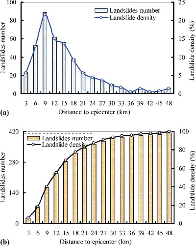
Landslide distributions were obtained as a function of distance from the epicentre. shows the statistical results of the number of landslides and landslide density vs. distance from the epicentre. Most of the landslides happened within 21 km from the epicentre, although there were a few landslides that happened over 40 km from the epicentre ((b)). Statistical analysis results of the landslides triggered by the 21 September 1999 Chi-Chi earthquake show that landslides occurred mainly in Tertiary sedimentary rocks and landslides were concentrated within distances of 40 and 70 km from the epicentre and the fault plane, respectively (Khazai & Sitar Citation2003). Statistical analysis results from the 2002 Avaj, Iran earthquake (Mw 6.5) show that the maximum epicentral and fault distances to a landslide were approximately 54 and 52 km, respectively (Mahdavifar et al. Citation2006). As shown in (a), the number of landslides first increased with increasing distance from the epicentre (0–9 km) and then decreased with increasing distance from the epicentre (>9 km). Most landslides happened in the river valley region because most of the earthquake energy was released in the areas near the epicentre. However, most of the river valley is a long distance from the epicenter, so that the landslides are concentrated at the distance range from 6–12 km. For the 2008 Wenchuan earthquake, statistical results show that more than 70% of the landslides were located within 3 km distance from the seismic fault and 80% within 5 km (Xu et al. Citation2011; Fan et al. Citation2012). Furthermore, most of the landslides were located at the hanging wall of the Longmenshan fault. However, for the landslides triggered by the Ludian earthquake, the terrain was relatively flat within 3 km of the epicentre, resulting in a small number of landslides in this region.
Figure 13. Statistical results of the landslide number and landslide density vs. distance from the epicenter: (a) scatter distribution and (b) cumulative distribution.
According to the spatial distribution characteristics of the landslides with a size that is larger than moderate scale, (a) shows that the landslides were variable distances from the fault and most were concentrated along the river valley region. Statistical results show that the cumulative area of the earthquake-triggered landslides in the seismic intensity IX region is about 10.2–15.2 km2 (almost the same cumulative landslide area in the seismic intensity VIII region); however, the cumulative landslide area is decreased into 1.8–2.3 km2 in the seismic intensity VII region. The earthquake-triggered landslides are concentrated in the strong seismic intensity regions (IX and VIII), and a small amount of the landslides are occurred far from the epicentre. (b) shows the spatial distribution of the large-scale landslides. The large-scale landslides were concentrated on the steep slope. As shown in , the distribution of the number of landslides was not only influenced by the distance from the epicentre or from the fault surface but also controlled by the geomorphologic condition.
Figure 14. (a) Spatial relationship between the landslides with the size larger than moderate scale and (b) spatial distribution of the large-scale landslides.
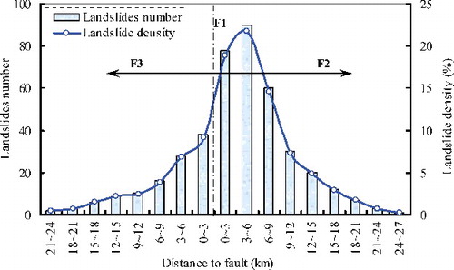
Most previous studies show that landslides triggered by earthquakes are usually concentrated along the seismogenic fault and the spatial distribution pattern is strongly controlled by the fault (Keefer Citation2000; Xu & Xu Citation2014). However, landslides triggered by earthquakes are not always concentrated along seismogenic faults, such as in the cases of the 1999 Chi-Chi earthquake and the 1994 Northridge, USA, earthquake (Khazai & Stiar Citation2003). The seismic pattern of the Ludian earthquake indicated that the direction of the earthquake rupture was from SW to NE. shows the number of landslides and landslide density vs. distance to the Xiyuhe-Zhaotong fault rupture. The majority of the landslides happened within a distance of 12 km from the fault rupture plane and the landslides decreased in density with distance from the fault rupture. More than 70% of the landslides occurred on the right side of the Xiyuhe-Zhaotong fault from SW to NE. Statistical analysis results of the landslides triggered by the 2008 Iwate-Miyagi Nairiku, Japan earthquake (Mw 6.9) show that more than 4100 landslides occurred on the hanging wall, but almost no landsides on the footwall (Yagi et al. Citation2009). The same result was also found for the landslides triggered by the Wenchuan earthquake; 71% of large landslides were located at the hanging wall side of the seismic fault (Xu et al. Citation2011).
Figure 15. Landslide number and landslide density vs. distance from the Xiyuhe-Zhaotong fault rupture.
4.2. Influence of slope aspect and gradient
Most of the previous earthquake events (Dai et al. Citation2011; Gorum et al. Citation2013; Huang et al. Citation2013; Li et al. Citation2013) show that the landslide density is increased with increasing slope gradient. On the contrary, Xu et al. (Citation2014b) found that the landslide density related to the Minxian-Zhangxian earthquake did not increase with increasing slope gradient. Landslide number and area densities in other classes show an obviously opposite trend to most previous results. For the landslides triggered by the Mw 6.5 Ludian earthquake, two sections are selected to analyze the influence of slope gradient and aspect on the landslides (the location of these two section lines are shown in (b)). As shown in (a), the giant landslides of Ganjiazhai and Hongshiyan all happened on steep slopes and the slope gradient for the Ganjiazhai landslide is approximately 0.6–1.1 and for Hongshiyan is approximately 0.7–1.4. The slope gradients near these two giant landslides are relatively large, so that numerous different scales of landslides were triggered in these two areas ((b)). This phenomenon also existed in other affected areas of the Ludian earthquake, where the landslide density increased with increasing slope gradient, regarding the co-seismic landslides triggered by the Ludian earthquake. Slope gradients have a great influence on the landslides triggered by the earthquake because there is the effect of ground-shaking amplification on higher topographic positions (Malamud et al. Citation2004; Meunier et al. Citation2007; Huang & Li Citation2009).
Figure 16. Landslide distribution influence of the slope gradient and aspect: (a) and (b) are the terrain conditions of sections 1–3 and 4 and 5 shown in (b); and (c) effect of the slope aspect.
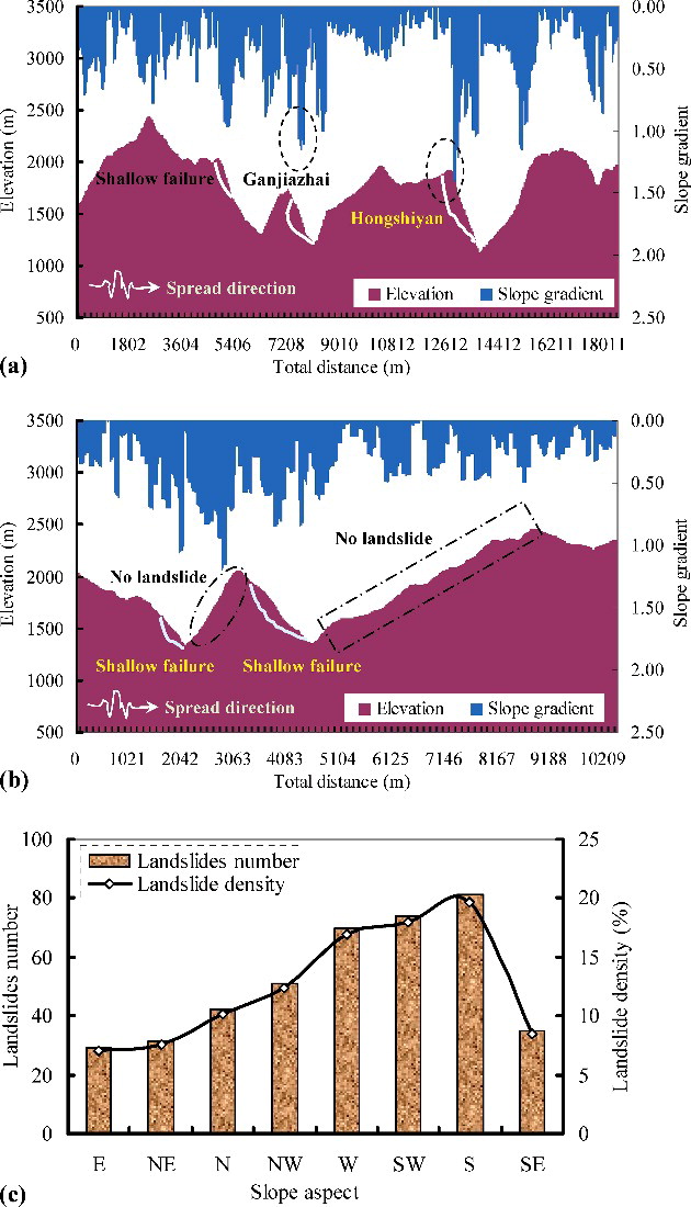
Regarding the landslides triggered by the Mw 6.5 Ludian earthquake, slope aspect had an effect on landslide distribution because the slope at different aspects experienced different directional peak ground acceleration. The relationship between landslide number and slope aspect in (c) shows the highest landslide number and area densities were for the west, south-wesouth, with a total of approximately 57%. Most of the landslides happened at the back slope with respect to the earthquake epicentre, with a total of approximately 65%; however, the landslide happened at the facing slope is approximately 35%. The correlations between topographic position and the number of landslides show similar trends to previous studies, such as the 2008 Wenchuan earthquake (Xu and Li Citation2010; Xu et al. Citation2011) and the 2010 Haiti earthquake (Gorum et al. Citation2013). As shown in (a), these two giant landslides (Ganjiazhai and Honhshiyan) were located at the back slope with steep terrain (larger slope gradient). Also, as depicted in (b), for sections 4 and 5, there were no landslides on the facing slope, no matter what the slope gradient, but several shallow slides happened at the back slope. Statistical results summarizing the landslides triggered by the Ludian earthquake show the landslide spatial distribution was influenced by the slope aspect.
5. Conclusions
Hundreds of landslides were triggered by the 2014 Ludian earthquake, which had a magnitude of Mw 6.5. The landslides can be divided into four main types, including slides (shallow slides and deep-seated slides), rock falls, debris flows and unstable slopes. With the help of field investigations and remote sensing images, 249 landslides before the Ludian earthquake and 413 landslides after the Ludian earthquake were detected and used for the statistical analyses. Spatial distribution characteristics, influenced by the distance from the epicentre or fault rupture surface, slope aspect and slope gradient for the landslides in the earthquake area are discussed.
The results from statistical analysis show that 96% of the landslides are small to moderate in scale. Most of these landslides were concentrated near the epicentre, especially at the upper slope along the river valley. The main types of landslide were slides and rock falls in quaternary deposits layers or strongly weathered rock masses, with a total of 83%. Most of the landslides were small to moderate in scale (landslide volume smaller than 100 × 104 m3), with a total of 96%. The landslide numbers first increased with increasing distance from the epicentre (0–9 km) and then decreased with increasing distance from the epicentre (>9 km); most of the landslides were concentrated within the distances ranging from 6–12 km. The majority of the landslides happened within a distance of 12 km from the fault rupture plane. The landslides decreased in density with distance from the fault rupture. More than 70% of the landslides occurred on the right side of the Xiyuhe-Zhaotong fault from SW to NE. Statistical results for the landslides triggered by the Ludian earthquake show that landslide density was increased with increasing slope gradient. Approximately 65% of the landslides happened at the back slope with respect to the earthquake epicentre; however, the landslide happened at the facing slope is approximately 35%.
Considering the limitations of time and dangerousness of the field investigations, only 413 landslides were detected. Some unknown landslides may have happened in the affected area of the Ludian earthquake, especially for small-scale shallow slides, which would change the statistical numbers in this work. In addition, landslide initiation mechanisms are a complex problem related to the seismic dynamics, tectonic effects, rock and soil mechanics, geomorphology, geology and other factors. In this paper, preliminary results for the spatial distribution and the geological and geomorphologic characteristics of landslides triggered by the Ludian earthquake are discussed so that further studies on the causes of the spatial distribution characteristics of this landslide event can be carried out.
Acknowledgements
We gratefully acknowledge the support of the National Natural Science Foundation of China (41472272, 41102194) and the Science Foundation for Excellent Youth Scholars of Sichuan University (2013SCU04A07). Critical comments by two anonymous reviewers greatly improved the initial manuscript.
Disclosure statement
No potential conflict of interest was reported by the authors.
Additional information
Funding
References
- Chigira M, Wang W-N, Furuya T, Kamai T. 2003. Geological causes and geomorphological precursors of the Tsaoling landslide triggered by the 1999 Chi-Chi Earthquake, Taiwan. Eng Geol. 68:259–273.
- Chigira M, Yagi H. 2006. Geological and geomorphological characteristics of landslides triggered by the 2004 Mid Niigta prefecture earthquake in Japan. Eng Geol. 82:202–221.
- Collins BD, Kayen R, Tanaka Y. 2012. Spatial distribution of landslides triggered from the 2007 Niigata Chuetsu–Oki Japan Earthquake. Eng Geol. 127:14–26.
- Cruden DM, Varnes DJ. 1996. Landslide types and processes. In: Turner AK, Schuster RL, editors. Landslides, investigation and mitigation. Washington, DC: Transportation Research Board; p. 36–75. Special Report 247.
- Dai FC, Xu C, Yao X, Xu L, Tu XB, Gong QM. 2011. Spatial distribution of landslides triggered by the 2008 Ms 8.0 Wenchuan earthquake, China. J Asian Earth Sci. 40:883–895.
- Fan X, Zhang Y, Yang J. 2012. [Developmental characteristics and influence factors of landslides in Wenchuan earthquake]. J Nat Disasters. 21:128–134. Chinese.
- Gorum T, van Westen CJ, Korup O, van der Meijde M, Fan XM, van der Meer FD. 2013. Complex rupture mechanism and topography control symmetry of mass-wasting pattern, 2010 Haiti earthquake. Geomorphology. 184:127–138.
- Harp EL, Jibson RW. 1996. Landslides triggered by the 1994 Northridge, California earthquake. Bull Seismol Soc Am. 86:319–332.
- Hu J, Li B, Tang L, Tang C. 2007. [Study on characteristics and formation factor of geological hazards in Ludian County of Yunnan Province]. J Geol Hazard Environ. Preservat. 18:15–19. Chinese.
- Huang R, Li G, Ju N, Zhao J. 2013. Statistical analysis of the key factors of landslide induced by Wenchuan earthquake. In: Ugai K, Yagi H, Wakai A, editors. Earthquake-induced landslides. p. 925–936. Berlin: Springer-Verlag.
- Huang R, Li W. 2009. [Fault effect analysis of Geo-hazard triggered by Wenchuan earthquake]. J Eng Geol. 17:19–28. Chinese.
- Hungr O, Evans SG, Bovis MJ, Hutchnison NJ. 2001. A review of the classification of landslides of the flow type. Environ Eng Geosci. 7:221–238.
- Jibson RW, Harp EL, Michael JA. 2000. A method for producing digital probabilistic seismic landslid hazard maps. Eng Geol. 58:271–290.
- Jin M, Yang J, Chen J, Li X. 2014. Overview of the M 6.5 Yunan Ludian earthquake in August 3, 2014. Prog Geophys. 29:1980–1984. Chinese.
- Keefer DK. 1984. Landslides caused by earthquakes. Geol Soc Am Bull. 95:406–421.
- Keefer DK. 2000. Statistical analysis of an earthquake-induced landslide distribution – the 1989 Loma Prieta, California event. Eng Geol. 58:231–249.
- Khazai B, Sitar N. 2003. Evaluation of factors controlling earthquake-induced landslides caused by Chi-Chi earthquake and comparison with the Northridge and Loma Prieta events. Eng Geol. 71:79–95.
- Kuang W, Chi W, Gao C, Du G, Pan T, Yang T, Liu A. 2014. [Environmental conditions for rescue and earthquake impact rapid assessment in Ludian Earthquake area, Yunnan Province]. Prog Geogr. 33:1152–1158. Chinese.
- Li WL, Huang RQ, Tang C, Xu Q, van Westen C. 2013. Co-seismic landslide inventory and susceptibility mapping in the 2008 Wenchuan earthquake disaster area, China. J Mt Sci. 10:339–354.
- Li X, Zhang JG, Xie YQ, Miao QW. 2014. Ludian Ms 6.5 earthquake surface damage and its relationship with structure. Seismol Geol. 26:1280–1291.
- Mahdavifar MR, Solaymani S, Jafari MK. 2006. Landslides triggered by the Avaj, Iran earthquake of June 22, 2002. Eng Geol. 86:166–182.
- Malamud BD, Turcotte DL, Guzzetti F, Reichenbach P. 2004. Landslide inventories and their statistical properties. Earth Surf Proc Land. 29:687–711.
- Meunier P, Hovius N, Haines AJ. 2007. Regional patterns of earthquake-triggered landslides and their relation to ground motion. Geophys Res Lett. 34:L20408.
- Xu C, Xu X. 2014. The spatial distribution pattern of landslides triggered by the 20 April 2013 Lushan earthquake of China and its implication to identification of the seismogenic fault. Chinese Sci Bull. 59:1416–1424.
- Xu C, Xu X, Shen L, Dou S, Wu S, Tian Y, Li X. 2014a. Inventory of landslides triggered by the 2014 Ms 6.5 Ludian earthquake and its implications on several earthquake parameters. Seismol Geol. 26:1186–1203.
- Xu C, Xu X, Shyu JBH, Zheng W, Min W. 2014b. Landslides triggered by the 22 July 2013 Minxian–Zhangxian, China, Mw 5.9 earthquake. J Asian Earth Sci. 92:125–142.
- Xu Q, Li W. 2010. [Study on the direction effects of landslides triggered by Wenchuan earthquake]. J Sichuan University (Eng Sci Ed). 42:7–14. Chinese.
- Xu Q, Zhang S, Li W. 2011. Spatial distribution of large-scale landslides induced by the 5.12 Wenchuan Earthquake. J Mt Sci. 8:246–260.
- Yagi H, Sato G, Higaki D, Yamamoto M, Yamasaki T. 2009. Distribution and characteristics of landslides induced by the Iwate–Miyagi Nairiku Earthquake in 2008 in Tohoku District, Northeast Japan. Landslides. 6:335–344.
- Zhou J, Cui P, Yang X. 2013. Dynamic process analysis for the initiation and movement of the Donghekou landslide-debris flow triggered by the Wenchuan earthquake. J Asian Earth Sci. 76:70–84.