
ABSTRACT
In the autumn of 2014, a series of rainfall events affected several sectors of the Liguria region, triggering many shallow landslides and causing three casualties and severe structural damages. The most intensely unstable area covered 385 km2, in which more than 1600 landslides have been identified. After these events, an airborne Light Detection and Ranging survey was carried out. The survey yielded a high-resolution digital terrain model (DTM) and aerial images that provided a means of identifying and mapping all the occurred landslides. The distribution analysis of slope instabilities highlighted the link with various human activities. In fact, the majority of the detected landslides occurred in man-modified areas. Geospatial and statistical analyses provided the identification of three main anthropic factors: terraces, their level of maintenance and road network. Moreover, they quantified their role in landslide triggering. These factors were not analysed as separate elements, but as a continuous process, overlapping in time, in man-made influence on landscape. The identification of such factors is a key element for a correct behaviour characterization of this landscape towards extreme flash floods events.
1. Introduction
In the past centuries, human intervention has caused remarkable changes in hilly and mountain landscapes (Remondo et al. Citation2005; García-Ruiz Citation2010). Human activities principally modified the natural drainage patterns, the original slope profile and cut forest for farming. In the literature, it has been recognized that land use change associated to landscape morphology is one of the main factors influencing landslide occurrence and, in particular, of rainfall-triggered ones (Glade Citation2003; Beek and Asch Citation2004; Bruschi et al. Citation2013). Many authors analysed the relationship between geo-hydrological processes, triggered by intense rainfall events, and the landscape characteristics (Wasowski Citation1998; García-Ruiz et al. Citation2008; Galve et al. Citation2015). In Liguria region (northwestern Italy), man-made intervention represented noteworthy morphogenetic impact. The acknowledgments of the human effect were achieved already in the Middle Ages, when anthropic terraces have been principally employed for cultivation (Canuti et al. Citation2004; Cevasco et al. Citation2014; Tarolli et al. Citation2014). The employment of such structures was prolonged over time, recording an overlapping with the accelerating rate of human intervention during the following century, principally represented by urban areas and road network development. The current landscape setting offers the opportunity to observe a long-term land use history, arising from the overlap of various factors, (1) terraces, (2) their level of maintenance and (3) road network, developed by the man over time.
As previously stated, in Mediterranean area, terraces induced deep anthropic landform changes on steep slope (Lasanta et al. Citation2000; Varotto Citation2008; Kizos et al. Citation2010), and have been recognized as a European cultural heritage (Varotto Citation2008; Arnaez et al. Citation2011). In Italy, terraces are widespread features (Agnoletti et al. Citation2011; Cullotta and Barbera Citation2011; Camera et al. Citation2014). Particularly, in Liguria region, anthropic terraces are widely spread throughout the territory, with and important presence on the valley flanks of the hills (Sereni Citation1997). Generally, terrace building modified terrain profile, varying the original profile with bench structures, constituted by vertical dry-stone walls supporting the cultivated portion. These anthropogenic modifications reduce the slope gradient and the hydrological connectivity, decreasing erosion by controlling surface run-off (Gallart et al. Citation1994; García-Ruiz Citation2010; Stanchi et al. Citation2012). However, terraces assure their positive role in slope stability, by regulating run-off and rainfall infiltration, only through their constant maintenance.
Since the twentieth century, a progressive abandonment of agriculture has been recorded (Ales et al. Citation1992; García-Ruiz and Lana-Renault Citation2011; Tarolli et al. Citation2014; Arnáez et al. Citation2015). This condition determined a progressively decrease of terrace maintenance. Its lack promotes water erosion processes, local collapses of vertical stone walls and an increase of soil loss and slope failure (Koulouri and Giourga Citation2007; García-Ruiz and Lana-Renault Citation2011; Dotterweich Citation2013; Tarolli et al. Citation2014). Among these occurrences, shallow landslides are one of the most common phenomena that can arise on terraced territories (Crosta et al. Citation2003; Canuti et al. Citation2004; Camera et al. Citation2014). Shallow landslides are small volume of earth featuring reduced thickness (less than 2 m). They are triggered either by high-intensity rainfall, or by prolonged low-intensity rainfall (Caine Citation1980; Guzzetti et al. Citation2004; Frattini et al. Citation2009). Due to their high-velocity and high-impact forces, strongly conditioned by morphological and geological settings, these phenomena are a recurrent problem in steep slope regions. Consequently in Liguria, due to its landscape, urban settlements are exposed to severe threats (Brandolini et al. Citation2008; Cevasco et al. Citation2013; Galve et al. Citation2015).
It should be noted that in Liguria region, the current population growth rate represents a huge push factor for the development of urbanized areas also in hazardous areas (Brandolini et al. Citation2008; Cevasco et al. Citation2008; Brandolini et al. Citation2012; Faccini, Luino, et al. Citation2015) in both flat and slope areas (Brandolini et al. Citation2012; Faccini et al. Citation2016). This demanded a communication lines improvement across the valleys flanks, to enhance the accessibility to urban facilities and causing a further change of the original profile of the slope. These conditions, associated to the severe morphological setting, composed by hill and mountain hinterland, with steep slope, surrounding restricted flat areas principally distributed along the coast, constitutes a rainfall-induced landslides prone area. A meaningful aspect causing a likely increase of shallow landsliding and potential erosion in mountain areas is represented by road network (Wemple et al. Citation2001; Borga et al. Citation2004; Tarolli et al. Citation2013). Roads could provide remarkable alterations of the natural water flow. They alter the flow direction, concentration of run-off on the road surface and the subsurface interception by the cut-slope. All these aspects lead to the modification of the erosion pattern and the slope stability, supporting rainfall-induced landslides and mass movement (Borga et al. Citation2004; Cevasco et al. Citation2008; Tarolli et al. Citation2013; Jaboyedoff et al. Citation2016).
After a heavy rainfall event, landslides inventory and mapping constitute a reliable instrument to define the landslides distribution, types and patterns in relation to morphological, geological and land use settings. Nowadays, various methods and techniques for mapping the surface characteristics of landslides are available (Guzzetti et al. Citation2012). Depending on the extent of the area of interest, a long and wasteful fieldwork could be necessary, with potential problems of inaccuracy or incompleteness. The renown Light Detection and Ranging (LiDAR) technique can provide three-dimensional digital representation of the topographic surface, of large areas, by generating high-resolution digital terrain models (DTMs) (Cavalli et al. Citation2008; Tarolli and Dalla Fontana Citation2009). A DTM is able to provide enough resolution to detect and identify landslides, observing not only their sizes, but also their effects with respect to the landscape analysed (Ardizzone et al. Citation2007; Jaboyedoff et al. Citation2012). The LiDAR survey and associated aerial photos allow acquiring qualitative and quantitative data for morphological features (Ardizzone et al. Citation2007; Baldo et al. Citation2009; Razak et al. Citation2013). High-resolution DTM and derivative products (e.g. shaded relief, slope, aspect, roughness and contours) constitute a fundamental tool aimed to the analysis of topographic surface and the identification of morphometric landslide features, otherwise recognizable with laborious and time-consuming fieldwork.
In the autumn of 2014, a number of rainfall events occurred over wide areas of the central and the eastern part of the Liguria region (Faccini, Giostrella, et al. Citation2015; Silvestro et al. Citation2016). These heavy rainfalls occurred from October to November. They generated widespread floods and triggered thousands of shallow landslides, leading to severe structural damages and, unfortunately, three causalities. The most affected areas are three sectors of Liguria region: (1) Masone-Genova (MG), (2) Polcevera-Scrivia (PS) and (3) Chiavari (C). The presented study focuses on these areas, totaling 385 km2 approximately, for the following purposes: (1) inventorying the occurred landslides, (2) analysing type and extent of these phenomena and (3) identifying the linkages between this widespread man-made environment and slope instability. Based on the dedicated post-event LiDAR survey data (high-resolution DTM and aerial photos) high quality morphometric variables have been computed and collected. Produced data were statistically analysed to quantify the most significant relationship between landslide occurrence and man-made land use features. These human evidences (i.e. terraces, their level of maintenance and road network) that should affect slope stability, are considered as sequence of factors, which display an overlap over time that produce the current landscape setting. The proposed approach should provide data for a better awareness of the deep interrelationship between landslide occurrence and natural and human land use modifications. Furthermore, they represent a preliminary step toward landslide susceptibility definition in a high-human modified landscape.
2. Materials and methods
A preliminary analysis of the landscape settings in the damaged areas, after autumn 2014 rainfall, was performed. The methodology, aimed to the assessment of the landscape response to these rainfall events, is made of the following steps ():
| (1) | LiDAR survey and post-processing; Figure 1. Flow chart of the methodology applied. 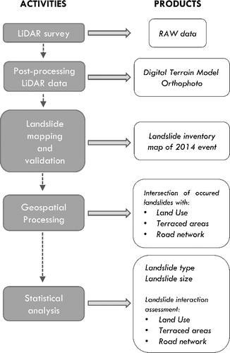 | ||||
| (2) | Landslides survey (by visual analysis of aerial photos and DTM derivative products) and field checks; | ||||
| (3) | Landslides inventory validation; | ||||
| (4) | Geospatial processing; | ||||
| (5) | Statistical analysis. | ||||
2.1. Study area
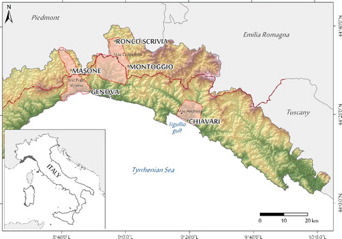
The study focuses on the three above-mentioned sectors of Liguria region (). The MG and PS areas are both located in the central-western ‘Centro-Ponente’ portion of the region, and their extension is 121 and 185 km2, respectively. C area is located in the eastern part ‘Levante’ and covers a surface of approximately 79 km2. All areas feature mountain landscape overlooking the sea, consisting of small catchments with high relief, steep slopes and abrupt descend to the coastline (Brancucci and Paliaga Citation2006). Restricted flat areas, surrounded by hill and mountain hinterland, are occupied by the main settlements (i.e. Genova, Chiavari), and display a widespread overbuilding.
Figure 2. Relief terrain of the study area within the Liguria region (northwestern Italy); the three areas of Masone-Genova (MG), Polcevera-Scrivia (PS) and Chiavari (C) are highlighted in light red; red dash-dot line represents the ‘Ligure-Padano’ watershed.
The geological context is rather complex, going through the Ligurian Alps in the west to the Northern Apennines in the east. The PS and MG areas fall entirely within the junction sector between the Alps and the Apennines. This complex structural asset, derived from two opposite vergent orogenic belts (Abbate et al. Citation1970; Piana and Polino Citation1995), is joined by a transition zone, represented by the ‘Sestri-Voltaggio Zone’ (Vignaroli et al. Citation2009; Molli et al. Citation2010).
The structural setting presents a complex evolution, involving stack of tectonic units, correlated to the distinct Alpine phase (i.e. subduction and exhumation phases), and Apennine phase (i.e. convergent trend). A post-orogenic phase, characterized by brittle tectonics, generated important N-S oriented fault system, which generates a strictly control for the drainage network (Marini Citation1987). Proceeding from west to east, different tectonic units outcrop. The MG sector is completely included in the Voltri Unit, consist of oceanic crust and mantle units. The bedrock, in this area, is mainly represented by two lithological formations, consist of serpentine schists (Bric del Dente Fm.) and calceschists (Turchino Fm.) (Capponi and Crispini Citation2008). In the western sector of PS, outcrops the Gazzo-Isoverde Unit, included in the ‘Sestri-Voltaggio Zone’, between the Figogna Unit and the Palmaro-Caffarella Unit. The bedrock consists of a meta-sedimentary succession of dolomites (Monte Gazzo Fm.), gypsum levels (Rio Riasso Fm.), limestones (Gallaneto Fm.) and mudstones (Bessega Fm.). Proceeding from west to east, outcrop: (1) the Monte Figogna Unit, consists of oceanic crust and mantle units and included in the ‘Sestri-Voltaggio Zone’; (2) and a number of units consisting of flysch succession and including the Mignanego Unit, the Montanesi Unit and the Ronco Unit (Capponi and Crispini Citation2008). The bedrock is mainly composed of turbiditic with fine- and medium-grained sandstone and mudstone flysch. The C area falls entirely within the Northern Apennines flysch succession (Abbate et al. Citation1970; Marroni et al. Citation2002). The area is included in the Internal Ligurian Units, which consist of the most complete and preserved section of the ‘Ligure-Piemontese’ ocean basin (Abbate Citation1980). These units comprise an ophiolitic sequence and a hemipelagic cover (Calpionella Limestone and Palombini Shales, Upper Jurassic to Lower Cretaceous), associated with a complex turbiditic sequences (Molli et al. Citation2010). The bedrock of this latter sequence consists of siliciclastic and carbonate turbidites, represented by a series of formations: (1) Magnesiferous Shale, (2) Mt. Verzi Marl, (3) Zonati Shale and (4) Gottero Sandstone.
Morphologically, in MG and PS areas, the main watershed ‘Ligure-Piemontese’ (), with an average height of 600–700 m a.s.l., divides the northern side (Po plain side) to the southern side (Tyrrhenian sea side). Generally, the Po flank basins have gentle slopes and longer grade toward the bottom of the valleys, presenting wide and meandering watercourses (Lorenz Citation1984; Spagnolo and Firpo Citation2007). MG and PS areas cross part of two of the principal northern basins, respectively the Stura River and the Scrivia River basins. Instead, Tyrrhenian flank shows limited extension coastal basins, characterized by valleys prevalently N-S oriented, very-steep slopes, with presence of regressive erosive landforms and short watercourses (Brancucci and Paliaga Citation2006). The main southern basins of the MG and PS areas are, respectively the Leira River and the Polcevera River basins. Instead, C area shows the typical morphological feature of the Tyrrhenian side, crossing the terminal portion of the Entella River and Lavagna River, and the Rupinaro catchment, close to the Chiavari municipality, characterized by small sub-basins with very high relief and short watercourses. The average slope angle of the three study areas is approximately 25°, due to the presence of terraces and other man-made structures, but there are local sectors reaching values up to 60°.
The land cover of the three areas prevalently consists of forests and natural grasslands, ranging from 55% (C area) to 70% (MG and PS areas) ((a)). The greatest part consists of mesophylous, conifer and chestnut forest, and of sclerophyllous vegetation and transitional woodland-scrub. This indicates a landscape marked by human presence and signal of progressive transformation process from cultivated areas through their abandonment and spontaneous renaturation.
Figure 3. (a) Percentages of land use types in the three study areas; light grey = artificial surfaces, orange = agricultural areas, and green = forest and semi-natural areas (from Land Use of 2015, 1:10.000 scale, Liguria Region). (b) Percentages of the main agricultural areas sub-classes observed in the study areas; in dark grey vineyards and olive groves, in grey cultivated lands and pastures and in light grey agricultural areas with significant natural vegetated areas.
The agricultural areas, in MG and PC sectors, occupy less than 20% of their extents; while in C sector the 30%. Generally, in MG and PS sectors, the agricultural areas consist prevalently of non-irrigated arable lands, pastures and complex cultivation patterns ((b)), and only a minor part of vineyards, olive groves and greenhouses. Relevant part of these areas also consists of land principally occupied by agriculture, with remarkable areas of natural vegetation. Instead, in C area, most of the agricultural areas consist of vineyards, olive groves and greenhouses ((b)). The artificial areas occupy less than 15% of the landscape. The urbanized areas are prevalently distributed along the coast and the main valleys bottoms, with local distribution along the valleys flanks. Generally, the restricted flat areas are overurbanized, showing a growth also toward steep slopes. Communication lines through the slope and road network cross and cut the high-relief valleys flanks, connecting the scattered hamlets along the slope.
2.2. The autumn of 2014 rainfall events
In the autumn season of 2014, many severe and prolonged rainfall events affected the central and eastern part of the Liguria region. The most intense events occurred over a rather short period between mid-October (9–13) and mid-November (9–13). Heavy rainfalls, which prevalently affected Genova municipality and Tigullio hinterland (central Liguria), have characterized the meteorological event of 9 October. The storm began at 7:00 am, lasted about 9 hours, affecting the coastal sectors, and presenting a gradual precipitation reduction during the afternoon. In the Genova hinterland, a second event began at 8:00 pm featuring a heavy and prolonged rainfall with a paroxysmal phase between 10:10 pm and 11:10 pm. The maximum cumulated rainfall rate was recorded at the Genova-Geirato weather station (141 mm/1 h, 396.6 mm/24 h) (Silvestro et al. Citation2016). The heavy rainfall occurred during the evening caused the Carpi stream flooding, close to the Montoggio municipality, and subsequently the Bisagno catchment flooding, with the overflow of Genova. This event caused high number of landslides in the Upper Scrivia catchment, particularly in the Montoggio municipality with serious damage and one casualty, as reported by the Regional Authority (ARPAL - CFMI - PC Citation2014a).
The following event on 10–13 October displayed very heavy rainfall, characterized by persistence for several days, concentrated in the central portion of the region. The phases of great intensity occurred at different times and in diverse places. First, the event affected the central part of the region (10–11 October), subsequently moved down east in the ‘Levante’ sector (11–12 October), and finally affected the central-western sector recording a precipitation reduction (ARPAL - CFMI - PC Citation2014b). The Genova hinterland and the upper Scrivia valley, close to Montoggio, were the most affected areas by the 10–11 October rainfall with cumulative rainfall of 294 mm/24 h (Vicomasso raingauge) and local peak of 110 mm/1 h (Genova-Pegli raingauge). During 11–12 October, the storm front moved to the eastern sector, recording cumulative rainfall of 156 mm/24 h, and peak of 79 mm/1 h (Casale Pignone raingauge). On 13 October, a stationary event affected the Genova hinterland, in particular Campoligure, Rossiglione and Montoggio municipalities, with cumulative rainfall of 268 mm/24 h and peak of 94 mm/1 h (Rossiglione raingauge). The Scrivia stream overflowed repeatedly on 10 October, and on the 11 October night, the Stura stream flooding has been recorded. Again, on 13 October the Stura stream tributaries overflowed close to Campoligure and Rossiglione municipalities. This event caused many shallow landslides, predominantly in Genova hinterland.
Finally, on 9–13 November a weather event with widespread and heavy rainfall, with local strong thunderstorms and a paroxysmal phase on 10 November between 5:00 pm and 0:00 pm, affected the Tigullio hinterland. The rainfall maximum rate was 67 mm/1 h as measured at Panesi raingauge and 60 mm/1 h (Chiavari-Caperana raingauge) (ARPAL - CFMI - PC Citation2014c). The cumulative rainfall reached its peak in the Entella catchment (170 mm/6 h); in the Lavagna catchment it amounted to 150 mm/6 h (Cevasco et al. Citation2015; Faccini, Giostrella, et al. Citation2015). This event caused the Entella catchment flooding, particularly affecting Chiavari municipality, triggered many shallow landslides, more meaningful in Leivi municipality, causing serious damages and two casualties (ARPAL - CFMI - PC Citation2014c).
2.3. LiDAR survey and post-processing
After the above-described rainfall events, the most intensely affected areas have been investigated. An airborne LiDAR survey, of the post-event damaged areas, was carried out between January and the beginning of April, covering a total area of about 385 km2. The LiDAR survey was performed later than the autumn rainfall events, due to the presence of snow cover in the higher elevation sectors, in order to minimize gaps in data acquisition. The selected survey interval ensured to avoid the presence of ground coverages, including foliage, too.
A helicopter-borne RIEGL LMS-Q680i sensor (Horn, Austria) scanned the original LiDAR acquisition. The scanning was performed at 300 KHz pulse-rate with a FOV (field of view) of 60° (+7°–30°). The accuracy of the laser instrument is 20 mm at 250 m above groud level (AGL), with a beam divergence of 0.5 mrad (50 cm at 1000 m AGL); variable under unfavourable conditions (e.g. weather conditions, poorly reflecting of the surface, roughness). The laser resolution gives the level of detail of the point cloud preformed, and is divided into range and angular resolution (Jaboyedoff et al. Citation2012). These parameters depend on the sampling interval, and on the laser beamwidth. The point density of acquisition varied from 4 to 9 points/m2, recording the elevation of both the first and the last return. The raw point cloud in LAS format has been georeferenced in ETRF2000 UTM zone 32N system, and in EGM2008 as vertical datum. Then, a TIN interpolation of the scanned data has been done to obtain a DTM with a 0.25 × 0.25 m resolution, with TerrascanTMsoftware suite.
The instrument was also equipped with a digital HASSELBLAD Digicam CH39 camera (39Mpixel), with 50 cm focal length objective, capable of generating terrestrial digital orthoimages, with ground resolution of 15 cm/pixel.
2.4. Landslides identification and validation
In the autumn of 2014 rainfall events, thousands of landslides occurred across the MG, PS and C areas. We operated over a large portion of the region with elevation ranges from the coastline to hill and mountain hinterland (Bric Prato d’Ermo 761 m, in MG; M.te Cappellino 703 m, in PS; M.te Anchetta peak 547 m, in C). Due to the great extent and the complexity of the involved areas, we prevalently operated by exploiting LiDAR data. This procedure is confirmed by several authors who analysed ground surface processes by means of high-resolution DTMs (Glenn et al. Citation2006; Ardizzone et al. Citation2007; Haneberg et al. Citation2009; Tarolli Citation2014; Pirasteh and Li Citation2016), also in forested areas (Eeckhaut et al. Citation2007; Razak et al. Citation2013; Chen et al. Citation2014) and for large territories (Eeckhaut et al. Citation2007). We employed a visual analysis methodology combining the high-resolution DTM and orthoimages. Simultaneously, in the post-event phase, ground verifications have been executed in order to define the principal morphological characteristics of the occurred phenomena. In addition, constant updates and communication with local authorities (e.g. regional technicians, municipal technicians, mayors), concerning information of phenomena location, were carried out.
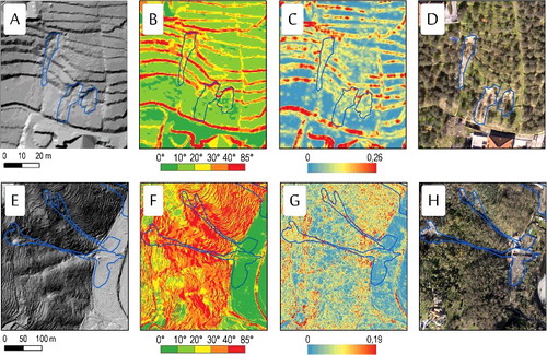
The high-resolution DTM supplied a detailed representation of the topographic surface able to provide a tool for recognition of landslides, and all the occurred surface morphology signatures (McKean and Roering Citation2004; Ardizzone et al. Citation2007; Derron and Jaboyedoff Citation2010; Razak et al. Citation2011; Chu, Chen, et al. Citation2014; Břežný and Pánek Citation2017). Several investigations demonstrated the effectiveness to perform landslide types recognitions and morphological parameters identification through high-resolution DTMs (Chigira et al. Citation2004; Glenn et al. Citation2006; Ardizzone et al. Citation2007; Chu, Wang, et al. Citation2014). We operated by processing the DTM in order to obtain several derivative products: (1) shaded relief, (2) slope and (3) roughness. The roughness has been calculated by the method proposed by Cavalli and Marchi (Citation2008). The comparison of the morphometric layers with the high-resolution orthoimages allowed investigating and mapping all the occurred morphological features ().
Figure 4. Examples of individuation and analysis of several rainfall-induced landslides located in C area. (A) shaded relief, (B) slope, (C) roughness and (D) orthoimage of three soil slips; (E) shaded relief, (F) slope, (G) roughness and (H) orthoimage of two debris flows, which caused two victims.
According to the described work flow, we identified landslides, their type and main morphological parameters (e.g. crown area, accumulation zone, body extent) at metric scale. We operated in an open source geographic information system (GIS) environment, particularly QGIS 2.18 (QGIS Development Team Citation2009), and we stored all the collected data in a spatial database. A landslide inventory map was then performed, and landslides were classified according to Cruden and Varnes (Citation1996). Simultaneously, we performed a validation analysis of the inventoried phenomena. This comparison intended to identify previous phenomena and possible reactivation cases and to verify the effective number of the landslides that occurred during the autumn of 2014. We compared the mapped landslides with the freely available Italian Landslide Inventory (Trigila et al. Citation2008). An additional analysis was performed using aerial photos available on regional web-portal (‘Liguria Geo-Portale’, AGEA 2013; ‘Portale Cartografico Nazionale’ 2012).
The resulting landslide map was constantly checked and updated in cooperation with local authorities. By a continuous cross-check between the mapped landslide and field surveys, operated by municipalities coordinated by regional authorities, the map was improved and updated.
2.5. Geospatial processing
In the described GIS environment, the landslide polygons were processed in order to retrieve spatial metrics such as their surface. Moreover, the intersection between each geometrical entity and several map layer was checked.
In order to compute the statistical test, independent variables were pre-processed in GIS environment. We started by grouping homogeneous categories from the land use data-set, available from the geoportal of Liguria region (Regione Liguria Citation2016) in vector format at 1:10.000 scale, in order to optimize classes and their distribution:
| (1) | Artificial surface; | ||||
| (2) | Agricultural areas; | ||||
| (3) | Forest and semi-natural areas. | ||||
The artificial surfaces category included all small localities, urban terrain and build-up areas, industrial and commercial factories, and road/rail networks. These areas show a general reduction in terrain permeability and can affect the natural drainage pattern (May Citation1996; Chin Citation2006; Kang and Marston Citation2006; Hall et al. Citation2014; Nardi et al. Citation2015). Concerning agricultural areas, generally, we observed that vineyards and olive groves are set in anthropic terraced areas presenting bench structures with dry-stone walls, in terrain with steep to very-steep slope. The cultivation patterns and pasture are still set in terraced areas presenting both bench with stone-walls and edge-structures without walls, in terrain with more gentle slope. Finally, the land occupied by agriculture with relevant areas of natural vegetation is featured by a reduced human intervention or a progressively renaturation. Based on our observation, a further subdivision of agricultural areas for the statistical analysis was done in:
| (1) | Vineyards, olive groves and greenhouses; | ||||
| (2) | Non-irrigated arable lands, pastures and complex cultivation patterns; | ||||
| (3) | Land principally occupied by agriculture, with significant areas of natural vegetation. | ||||
Those categories gather the main crop types related to the landscape characteristics. Finally, forest and semi-natural area class included broad-leaved forest, chestnut forest and coniferous forest. Furthermore, all transitional woodland-scrub areas, in which a natural degradation of the forest or recolonization of not-forested areas took place, were included.
We have then chosen to carry out more in-deep analyses of the road network sub-category. According to several authors (Jones et al. Citation2000; Duke et al. Citation2003; Borga et al. Citation2004; Jordán-López et al. Citation2009; Fu et al. Citation2010), communication lines can increase the susceptibility of terrain to erosion and shallow landslides. These linear elements constitute preferential material and energy transport routes across the land, crossing steep slopes and cutting and/or surmounting the downslope flow of drainage network. Roads can act as a barrier, a source or as flow-path corridors, thus conditioning lateral movement of the drainage network and favouring the occurrence of shallow landslides (Jones et al. Citation2000; Luce Citation2002; Tarolli et al. Citation2013). We identified all the possible intersections between landslides source areas and the road network. To avoid a long visual analysis of each inventoried landslides, we took advantage of a buffer analysis around road features, provided in vector format by the Liguria geoportal (Regione Liguria Citation2016), by setting a distance of 5 m, considered as reasonable distance of road infrastructure influence as it considers not only the road itself, but also drainage ditches or other features usually not mapped in the vector layer.
Moreover, another peculiar aspect of the region was considered. Anthropic terraces constitute the most widespread feature of the landscape in Liguria region. In our work, the high-resolution DTM and its derivative products provide a detailed representation of the topographic surface, useful to discriminate the presence of terraced areas. This also highlighted their presence in correspondence of forestland, normally not visible using traditional aerial photos analysis.
2.6. Statistical analysis
The landslide data were used to calculate descriptive statistics, and characterize the occurred landslides according to their type and size. Then, land features were statistically tested against landslide crown area with the purpose of pointing out potential relationships between land use and landslides occurrence. In fact, when analysing rainfall-induced landslides in a deeply human-modified landscape, its setting constitutes an important element in determining its hydrological response (Cevasco et al. Citation2014; Camera et al. Citation2015; Galve et al. Citation2015).
We applied the Pearson χ2 test for categorized data in a statistical open source environment (R Development Core Team Citation2011). This test leads to computation of the significance of relationship between occurred landslides and environmental parameters by comparing observed counts and expected values, which are the counts under the null hypothesis. It is an non-parametric test, used to gain an understanding of potential relationships between two classifications or variables (Gibbons, 1985). It highlights associations that should be a subject of further investigation.
We tested the significance of relationships between rainfall-induced landslides and the above-listed parameters (Remillard and Welch Citation1993). In order to point out the land use type more associated to landslides occurrence, we tested the three categories against each one pairwise. We performed an analogous test among ‘Agricultural areas’ subclasses. We computed contingency tables counting landslides according to their belonging to geographical area (C, MG, PS) and to the selected environmental variable. The null hypothesis is that the landslides are equally distributed across the landscape, if the null hypothesis is rejected it is possible to argue that occurrence of landslides is associated to the considered land features.
We applied the described procedure to test the association between shallow landslides and man-made structures, such as terraces and road, too.
3. Results
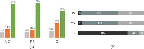
The landslide investigation, operated after the autumn of 2014 rainfall events, allowed the identification and mapping of 1641 rainfall-induced landslides in the 385 km2 analysed area, of Ligurian territory. In specific, in MG we mapped 493 phenomena, in PS 841 and in C 307 landslides. Further data are reported in Supporting Information . The landslides classification is based on the prevalent type of movement and material, according to the Cruden and Varnes (Citation1996) classification. Most phenomena corresponded to shallow landslides, including: (1) soil slips (98%), (2) debris flows (1%) and (3) debris avalanches (1%) ((a)). Few cases of rotational slides were also identified. The soil slips class includes shallow failures of colluvial soil with moderate volume. Generally, they present initial rotational or translational slide followed by an overflowing of the involved mass onto adjacent land. They normally occurred on steep slope, and should evolve in flowing debris that caused inundation and lateral impact, which could generate damages. The debris flows class defines all those water-laden mass of loose sediment and rock, canalized into stream channels. They rush down the slope by the erosion through the gullies and forming thick deposits at the base of the slope (Hungr et al. Citation2001). Finally, debris avalanches are the moving down mass of rock and soil. The debris flows are channeled movements, while debris avalanches are open-slope mass movements.
Figure 5. (a) Number of landslides for each study areas divided for type; (b) box plot of the landslide areas for each type of inventoried landslide. The black line corresponds to median. Dots are the outliers.
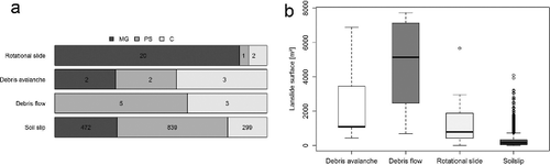
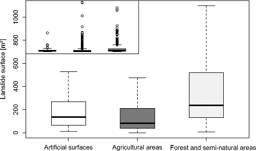
The shallow landslides mainly consisted of soil slip and generally exhibited reduced areal dimension ranging from tens to hundreds of square meters ((b)). Several extended debris flows and debris avalanches occurred in the three study areas, reaching meaningful size of thousands of square meters, one of which caused two fatalities in Leivi municipality. The main rotational slides occurred in MG area and presented reduced extents, ranging from hundreds to thousands of square meters. Concerning the full extent of the three study areas, we identify a mean distribution of approximately 4 slides/km2, primarily represented by shallow landslides. Observing the areal dimension respect to the land use classes, we noticed that in the ‘Forest and semi-natural areas’ classes are distributed the largest phenomena, in comparison with the other classes ().
Figure 6. Box plot of landslide areas for each type of land use intersection. The inset plot shows the same box plot with outliers.
Concerning land use and its relationship with landslides distribution, the Chi square test allowed us to carry out further in-depth analysis. It has highlighted a link between land use classes and landslide occurrences (χ2= 276.25, df = 4, p = ***). shows the counts of observed and expected landslides among the considered land use classes.
Table 1. Observed and expected distribution of landslides in the three areas according to the three land use classes.
The relative importance of the above-listed independent variables is presented in , which shows in the first subtable the observed and expected counts and in the second one the statistical significance of pairwise analyses. The Chi square values, calculated for each one, suggest that the ‘Agricultural surfaces’ categories are most strongly related to landslides distribution ().
Table 2. Pairwise comparison of land use classes and test results.
Table 3. Observed and expected distribution of landslides in the three areas according to the three agricultural sub-classes; 2a = vineyards, olive groves and greenhouses, 2b = non-irrigated arable lands, pastures and complex cultivation patterns, 2c = land principally occupied by agriculture, with significant areas of natural vegetation.
In detail, among agricultural subclasses, the analysis points out ‘Vineyards, olive groves and greenhouses’ as the most associated one in terms of landslides occurrence ( and ). Tables framework is the same as the previous ones.
Table 4. Pairwise comparison of agricultural sub-classes and test results.
Table 5. Observed and expected distribution of landslides intersecting anthropic features and test results.
Concerning man-made structures both terraces and roads have shown similar behaviour on landslide occurrence (), thus showing their effective influence.
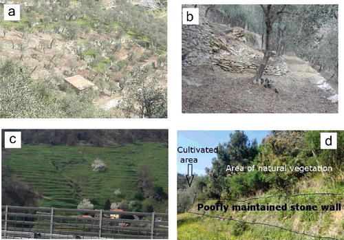
In light of these information, we inspected the field characteristics of the ‘Agricultural surfaces’ sub-categories, significantly to the level of maintenance of the terraces. In ‘Vineyard, olive groves and greenhouses’, terraces are prevalently characterized by bench structures with dry-stone walls, which likely show high level of maintenance and dry retaining walls ((a)). In some cases we observed local wall failures ((b)). In ‘Non-irrigated arable lands, pastures and complex cultivation patterns’, we observed a variable presence of stone-walls terraces and edge-structures without walls ((c)),which feature variable levels of maintenance and consequently diverse run-off responses. Finally, ‘Land principally occupied by agriculture, with significant areas of natural vegetation’ sub-class shows a heterogeneous landscape, still occupied by terraces, with a general poor maintenance of stone walls, and presenting a natural recolonization by forest and shrubs ((d)).
Figure 7. Observed terraces typologies; (a) bench structure with dry-stone walls; (b) small shallow landslide involving stone wall; (c) edge-structures; (d) poorly maintained dry-stone walls.
4. Discussion
Since the Middle Ages, the effect of human activities has been particularly evident in Liguria territory, which has been progressively and intensely modified landscape structure and appearance (Faccini et al. Citation2009; Brandolini et al. Citation2012). The landscape, almost completely occupied by hills and mountains with steep slopes, has been subjected to hundreds of years of human management, primarily represented by anthropic terraces, and later by road and urban area developments. Many authors analysed the influence of land use setting on rainfall-induced landslides occurrence during intense rainfall event in Liguria region (Cevasco et al. Citation2013, Citation2014; Galve et al. Citation2015; Brandolini et al. Citation2017). Most of them focused on restricted areas affected by rainfall-induced landslides. These studies surely constitute a detailed description of an unusual, but visible in the most part of the region, land use setting. This should provide a valuable starting point for the analysis of a wider area as that affected by the autumn of 2014 rainfall events (385 km2) and described in the present paper. Furthermore, our study analysed not only terraces, but also their interaction, their level of maintenance and road network, too. Our study, in fact, shows that the current scenario is the result of the progressive interaction and overlap of these three factors. These findings are based not only on expert-based evaluation, as carried out in previous works, but also on the results of statistical analyses. The availability of high-resolution DTM and orthoimages allowed us to acquire an accurate representation of the topographic surface and to detect anthropic features inducing landslides. Considering the land use classes adopted in the statistical analysis, ‘Agricultural areas’ (20% –30% of the land use of the entire analysed territory) are the most affected areas by shallow landslides than the forested and scrubland ones. We divided this category in the three most representative sub-classes, which generally present specific physiographical characteristics. Most of the detected territory display an anthropic terraced environment, and we opted for discerning from bench structure with dry-stone walls to edge-structures without stone walls. Through the statistical analysis, we have observed that further factor associate to landslides occurrence was represented by the presence of terraces. Connecting this feature with the considered agricultural sub-classes, we could deduce several considerations. Great attention was paid to the kind of terraces in these sub-classes, and their level of maintenance, as they may influence local or slope stability. It also displays different behaviours and responses to heavy rainfall event. In the cases of high level of maintenance, the wall of terraces responds with greater hydraulic conductibility and drains correctly the above run-off. We have noticed that a higher landslides density occurred in correspondence of cultivated terraced (Agricultural areas, Vineyard, olive groves and greenhouses), characterized by intermediate or progressive drop of wall maintenance, as already reported by Cevasco et al. (Citation2013, Citation2014). Instead, high-magnitude landslides seemed to be more concentrated in forest and semi-natural areas, in which a complete abandonment of terraces has been noticed.
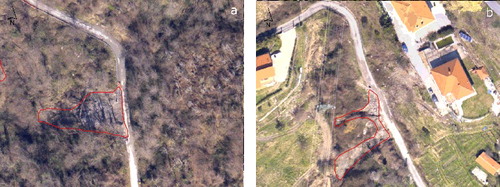
Concerning other considered anthropic element, the statistical analysis highlighted significant linkage between road structures and landslides occurrence. Communication lines building and development induced a slope re-profiling, linked to the decrease of slope stability and landslides occurrence induced by cut and fill for road constrictions (Jaboyedoff et al. Citation2016). We noticed that during the autumn heavy rainfall events, the pathways acted as a corridor, in which water and sediment transport have been gathered (). Often a cut and pass of the road network by the slides was detected during the field checks. In the study areas, a wide road network affects steeply slope territory, modifying the water flow direction and increasing the susceptibility to slope instability. In this context, roads are an influential factor in slope instability, and their occurrence is significantly correlated with shallow landslide.
Figure 8. Shallow landslides interaction with road network.
5. Conclusion
On the autumn of 2014 a series of rainfall events hit the ‘Centro-Ponente’ and the ‘Levante’ portions of Liguria, triggered thousands of shallow landslides and causing severe damages and three casualties. A total of 1641 shallow landslides were inventoried and analysed by airborne LiDAR survey of an area of 385 km2, associated to local field survey. A combined visual analysis of high-resolution DTM derived products (e.g. slope, shaded relief, roughness) and aerial photos, associated to field survey, implemented a landslide characterization, including type and principal morphological feature definition. The land use factor, strictly associated with human intervention, resulted a key issue in the occurrence of rainfall-induced landslides. The Liguria region has a long history of human impacts. It is characterized by widespread terraces and overbuilding, accompanied by stream modification and road network extensions. In this peculiar landscape, the influence of human management on slope stability during heavy rainfall and flash floods is a dominant factor. The comparison between occurred landslides and land use displays that terraced agricultural areas are the most prone area to shallow landslides than forest and semi-natural areas. The majority of landslides source area involved agricultural area occupied by vineyard, olive groves and greenhouses, although the degree of maintenance seems to be higher. In these sectors, the occurred landslides display small size, and often involved the terraces stone walls, while in woodland the landslides size were bigger. Furthermore, factor was represented by road network that indicates a significant relationship between communication lines and landslides occurrence. In conclusion, this paper provides a starting point to solve complex problems relating shallow landslide occurrence and land use changes over time, with a focus on the role of human impact on a landscape that has been significantly modified over the past few centuries. The results achieved should contribute to the assessment of the relationship between landslide occurrence and natural and human land use modifications, and constitute a preliminary step toward landslides susceptibility definition in a deeply human modified landscape.
Inventory_Map_Supplementary_material.jpg
Download JPEG Image (4.5 MB)
Acknowledgments
The research has been partially supported by Regione Liguria that founded LiDAR survey. The authors acknowledge in particular Flavio Poggi of the Settore Assetto del Territorio, Regione Liguria, and all the regional authorities that have contributed for the landslides validation activities.
Disclosure statement
No potential conflict of interest was reported by the authors.
Related Research Data
References
- Abbate E. 1980. Carta geologica dell ofioliti del Bargonasco e dell’Alta Val Graveglia (Lithografia Artistica Cartografica) [Geologic Map of the Bargonasco and High Graveglia Valley ophiolites (Artistic Litography)]. Firenze: Litografia Artistica Cartografica.
- Abbate E, Bortolotti V, Passerini P, Sagri M. 1970. Introduction to the geology of the Northern Apennines. Sediment Geol. 4(3):207–249. http://www.sciencedirect.com/science/article/pii/0037073870900175.
- Agnoletti M, Cargnello G, Gardin L, Santoro A, Bazzoffi P, Sansone L, Pezza L, Belfiore N. 2011. Traditional landscape and rural development: comparative study in three terraced areas in northern, central and southern Italy to evaluate the efficacy of GAEC standard 4.4 of cross compliance. Italian J Agron. 6(1s):16. http://agronomy.it/index.php/agro/article/view/ija.2011.6.s1.e16.
- Ales RF, Martin A, Ortega F, Ales EE. 1992. Recent changes in landscape structure and function in a mediterranean region of SW Spain (1950–1984). Landscape Ecol. 7(1):3–18. https://link.springer.com/article/10.1007/BF02573953.
- Ardizzone F, Cardinali M, Galli M, Guzzetti F, Reichenbach P. 2007. Identification and mapping of recent rainfall-induced landslides using elevation data collected by airborne Lidar. Nat Hazards Earth Syst Sci. 7(6):637–650. https://hal.archives-ouvertes.fr/hal-00299461/document.
- Arnaez J, Lasanta T, Errea MP, Ortigosa L. 2011. Land abandonment, landscape evolution, and soil erosion in a Spanish Mediterranean mountain region: the case of Camero Viejo. Land Degrad Dev. 22(6):537–550. http://onlinelibrary.wiley.com/doi/10.1002/ldr.1032/abstract.
- Arnáez J, Lana-Renault N, Lasanta T, Ruiz-Flaño P, Castroviejo J. 2015. Effects of farming terraces on hydrological and geomorphological processes. A review. CATENA. 128:122–134. http://www.sciencedirect.com/science/article/pii/S0341816215000351.
- ARPAL - CFMI - PC. 2014a. ARPAL 2014 – Rapporto di Evento Meteoidrologico del 09/10/2014. https://www.arpal.gov.it/.
- ARPAL - CFMI - PC. 2014b. ARPAL 2014 – Rapporto di Evento Meteoidrologico del 10-13/10/2014. https://www.arpal.gov.it/.
- ARPAL - CFMI - PC. 2014c. ARPAL 2014 – Rapporto di Evento Meteoidrologico del 9-13/11/2014. https://www.arpal.gov.it/.
- Baldo M, Bicocchi C, Chiocchini U, Giordan, D, Lollino G. 2009. LIDAR monitoring of mass wasting processes: the radicofani landslide, province of Siena, Central Italy. Geomorphology. 105(3–4):193–201. http://linkinghub.elsevier.com/retrieve/pii/S0169555X08004339.
- Beek LPHV, Asch TWJV. 2004. Regional assessment of the effects of land-use change on landslide Hazard by means of physically based modelling. Nat Hazards. 31(1):289–304. https://link.springer.com/article/10.1023/B:NHAZ.0000020267.39691.39.
- Břežný M, Pánek T. 2017. Deep-seated landslides affecting monoclinal flysch morphostructure: evaluation of LiDAR-derived topography of the highest range of the Czech Carpathians. Geomorphology. 285:44–57. http://www.sciencedirect.com/science/article/pii/S0169555X16311606.
- Borga M, Tonelli F, Selleroni J. 2004. A physically based model of the effects of forest roads on slope stability. Water Resour Res. 40(12):1–9.
- Brancucci G, Paliaga G. 2006. The hazard assessment in a terraced landscape: preliminary result of the Liguria (Italy) case study. In: Nadim F, Pöttler R, Einstein H, Klapperich H, Kramer S, editors. Proceedings of the Geohazards. Engineering Conferences International Symposium Series; Jun 18–21; Lillehammer (Norway): Engineering Conferences International. p. 18–21.
- Brandolini P, Cevasco A, Capolongo D, Pepe G, Lovergine F, Del Monte M. 2017. Response of terraced slopes to a very intense rainfall event and relationships with land abandonment: a case study from cinque terre (Italy). Land Degrad Develop. http://onlinelibrary.wiley.com/doi/10.1002/ldr.2672/abstract.
- Brandolini P, Cevasco A, Firpo M, Robbiano A, Sacchini A. 2012. Geo-hydrological risk management for civil protection purposes in the urban area of Genoa (Liguria, NW Italy). Nat Hazards Earth Sys Sci. 12(4):943–959.
- Brandolini P, Faccini F, Robbiano A, Terranova R. 2008. Relationship between flood hazards and geomorphology applied to land planning in the Upper Aveto Valley: (Liguria, Italy). Geogr Fis Dinam Quat. 31:73–82.
- Bruschi VM, Bonachea J, Remondo J, Gómez-Arozamena J, Rivas V, Barbieri M, Capocchi S, Soldati M, Cendrero A. 2013. Land management versus natural factors in land instability: some examples in Northern Spain. Environ Manage. 52(2):398–416. http://link.springer.com/article/10.1007/s00267-013-0108-7.
- Caine N. 1980. The rainfall intensity: duration control of shallow landslides and debris flows. Geogr Ann Phys Geogr. 62(1–2):23–27. http://www.jstor.org/stable/520449.
- Camera C, Apuani T, Masetti M. 2015. Modeling the stability of terraced slopes: an approach from Valtellina (Northern Italy). Environ Earth Sci. 74(1):855–868. https://link.springer.com/article/10.1007/s12665-015-4089-0.
- Camera CAS, Apuani T, Masetti M. 2014. Mechanisms of failure on terraced slopes: the Valtellina case (northern Italy). Landslides. 11(1):43–54. https://link.springer.com/article/10.1007/s10346-012-0371-3.
- Canuti P, Casagli N, Ermini L, Fanti, R, Farina P. 2004. Landslide activity as a geoindicator in Italy: significance and new perspectives from remote sensing. Environ Geol. 45(7):907–919.
- Capponi G, Crispini L. 2008. Note illustrative della carta geologica d’Italia alla scala 1: 50.000 Foglio 213 Genova [Explanatory notes of the geological map of Italy, 1:50000 scale, Sheet 213 Genova]. Firenze: SELCA.
- Cavalli M, Marchi L. 2008. Characterisation of the surface morphology of an alpine alluvial fan using airborne LiDAR. Nat Hazards Earth System Sci. 8(2):323–333. http://hal.archives-ouvertes.fr/hal-00299509/.
- Cavalli M, Tarolli P, Marchi L, Dalla Fontana G. 2008. The effectiveness of airborne LiDAR data in the recognition of channel-bed morphology. Catena. 73(3):249–260.
- Cevasco A, Brandolini P, Scopesi C, Rellini I. 2013. Relationships between geo-hydrological processes induced by heavy rainfall and land-use: the case of 25 October 2011 in the Vernazza catchment (Cinque Terre, NW Italy). J Maps. 9(2):289–298. http://dx.doi.org/10.1080/17445647.2013.780188.
- Cevasco A, Pepe G, Avanzi GD, Giannecchini R. 2015. A study on the 10 November 2014 intense rainfall and the related landslides in the lower Lavagna valley (eastern Liguria). Rendiconti Online Societa Geologica Italiana. 35:66–69.
- Cevasco A, Pepe G, Brandolini P. 2014. The influences of geological and land use settings on shallow landslides triggered by an intense rainfall event in a coastal terraced environment. Bull Eng Geol Environ. 73(3):859–875.
- Cevasco A, Robbiano A, Sacchini A, Vincenzi E. 2008. Hydrological thresholds for triggering shallow landslides in the area of the municipality of Genoa: the case study of the Bisagno Valley. Rendiconti Online Societá Geologica Italiana. 3(1):212–213.
- Chen W, Li X, Wang Y, Chen G, Liu S. 2014. Forested landslide detection using LiDAR data and the random forest algorithm: a case study of the Three Gorges, China. Remote Sens Environ. 152:291–301. http://www.sciencedirect.com/science/article/pii/S0034425714002491.
- Chigira M, Duan F, Yagi H, Furuya T. 2004. Using an airborne laser scanner for the identification of shallow landslides and susceptibility assessment in an area of ignimbrite overlain by permeable pyroclastics. Landslides. 1(3):203–209. https://link.springer.com/article/10.1007/s10346-004-0029-x.
- Chin A. 2006. Urban transformation of river landscapes in a global context. Geomorphology. 79(34):460–487. http://www.sciencedirect.com/science/article/pii/S0169555X06002637.
- Chu HJ, Chen RA, Tseng YH, Wang CK. 2014. Identifying LiDAR sample uncertainty on terrain features from DEM simulation. Geomorphology. 204:325–333. http://www.sciencedirect.com/science/article/pii/S0169555X13004212.
- Chu HJ, Wang CK, Huang ML, Lee CC, Liu CY, Lin CC. 2014. Effect of point density and interpolation of LiDAR-derived high-resolution DEMs on landscape scarp identification. GIScience Remote Sens. 51(6):731–747. http://dx.doi.org/10.1080/15481603.2014.980086.
- Crosta GB, Dal Negro P, Frattini P. 2003. Soil slips and debris flows on terraced slopes. Nat Hazards Earth Syst Sci. 3(1–2):31–42.
- Cruden D, Varnes D. 1996. Landslides types and processes. In: Turner AK, Schuster RL, editors. Landslides: investigation and mitigation. Transportation research board special report 247. Washington (DC):National Academy Press; p. 36–75.
- Cullotta S, Barbera G. 2011. Mapping traditional cultural landscapes in the Mediterranean area using a combined multidisciplinary approach: method and application to Mount Etna (Sicily; Italy). Landscape Urban Plan. 100(12):98–108. http://www.sciencedirect.com/science/article/pii/S0169204610002951.
- Derron MH, Jaboyedoff M. 2010. Preface “LIDAR and DEM techniques for landslides monitoring and characterization”. Nat Hazards Earth Syst Sci. 10(9):1877–1879.
- Dotterweich M. 2013. The history of human-induced soil erosion: geomorphic legacies, early descriptions and research, and the development of soil conservation–A global synopsis. Geomorphology. 201:1–34. http://www.sciencedirect.com/science/article/pii/S0169555X1300370X.
- Duke GD, Kienzle SW, Johnson DL, Byrne JM. 2003. Improving overland flow routing by incorporating ancillary road data into digital elevation models. J Spatial Hydrol. 3(2):1–27.
- Eeckhaut MVD, Poesen J, Verstraeten G, Vanacker V, Nyssen J, Moeyersons J, Beek LPHv, Vandekerckhove L. 2007. Use of LIDAR-derived images for mapping old landslides under forest. Earth Surf Process Landforms. 32(5):754–769. http://onlinelibrary.wiley.com/doi/10.1002/esp.1417/abstract.
- Faccini F, Giostrella P, Lazzeri R, Melillo M, Raso E, Roccati A. 2015. The 10th November 2014 flash-flood event in Chiavari city (Eastern Liguria, Italy). Rendiconti Online Soc Geol Italiana. 35:124–127.
- Faccini F, Luino F, Sacchini A, Turconi L, De Graff JV. 2015. Geohydrological hazards and urban development in the Mediterranean area: an example from Genoa (Liguria, Italy). Nat Hazards Earth Syst Sci. 15(12):2631–2652. http://www.nat-hazards-earth-syst-sci.net/15/2631/2015/.
- Faccini F, Paliaga G, Piana P, Sacchini A, Watkins C. 2016. The Bisagno stream catchment (Genoa, Italy) and its major floods: geomorphic and land use variations in the last three centuries. Geomorphology. 273:14–27. http://www.sciencedirect.com/science/article/pii/S0169555X16306560.
- Faccini F, Piccazzo M, Robbiano A. 2009. Natural hazards in San Fruttuoso of Camogli (Portofino Park, Italy): a case study of a debris flow in a coastal environment. Ital J Geosci. 128(3):641–654. http://italianjgeo.geoscienceworld.org/content/128/3/641.
- Frattini P, Crosta G, Sosio R. 2009. Approaches for defining thresholds and return periods for rainfall-triggered shallow landslides. Hydrol Process. 23(10):1444–1460. http://onlinelibrary.wiley.com/doi/10.1002/hyp.7269/abstract.
- Fu B, Newham LTH, Ramos-Scharrón CE. 2010. A review of surface erosion and sediment delivery models for unsealed roads. Environ Model Softw. 25(1):1–14. http://www.sciencedirect.com/science/article/pii/S1364815209001832.
- Gallart F, Llorens P, Latron J. 1994. Studying the role of old agricultural terraces on runoff generation in a small Mediterranean mountainous basin. J Hydrol. 159(1):291–303. http://www.sciencedirect.com/science/article/pii/0022169494902623.
- Galve JP, Cevasco A, Brandolini P, Soldati M. 2015. Assessment of shallow landslide risk mitigation measures based on land use planning through probabilistic modelling. Landslides. 12(1):101–114. http://link.springer.com/article/10.1007/s10346-014-0478-9.
- García-Ruiz JM. 2010. The effects of land uses on soil erosion in Spain: a review. CATENA. 81(1):1–11. http://www.sciencedirect.com/science/article/pii/S034181621000010X.
- García-Ruiz JM, Lana-Renault N. 2011. Hydrological and erosive consequences of farmland abandonment in Europe, with special reference to the Mediterranean region – A review. Agr Ecosyst Environ. 140(34):317–338. http://www.sciencedirect.com/science/article/pii/S0167880911000041.
- García-Ruiz JM, Regüés D, Alvera B, Lana-Renault N, Serrano-Muela P, Nadal-Romero E, Navas A, Latron J, Martí-Bono C, Arnáez J. 2008. Flood generation and sediment transport in experimental catchments affected by land use changes in the central Pyrenees. J Hydrol. 356(12):245–260. http://www.sciencedirect.com/science/article/pii/S0022169408001972.
- Glade T. 2003. Landslide occurrence as a response to land use change: a review of evidence from New Zealand. CATENA. 51(34):297–314. http://www.sciencedirect.com/science/article/pii/S0341816202001704.
- Glenn NF, Streutker DR, Chadwick DJ, Thackray GD, Dorsch SJ. 2006. Analysis of LiDAR-derived topographic information for characterizing and differentiating landslide morphology and activity. Geomorphology. 73(12):131–148. http://www.sciencedirect.com/science/article/pii/S0169555X05002047.
- Guzzetti F, Cardinali M, Reichenbach P, Cipolla F, Sebastiani C, Galli M, Salvati P. 2004. Landslides triggered by the 23 November 2000 rainfall event in the Imperia Province, Western Liguria, Italy. Eng Geol. 73(34):229–245. http://www.sciencedirect.com/science/article/pii/S0013795204000225.
- Guzzetti F, Mondini AC, Cardinali M, Fiorucci F, Santangelo M, Chang KT. 2012. Landslide inventory maps: new tools for an old problem. Earth Sci Rev. 112:42–66. http://adsabs.harvard.edu/abs/2012ESRv..112...42G.
- Hall J, Arheimer B, Borga M, Brázdil R, Claps P, Kiss A, Kjeldsen T, Kriauciuniene J, Kundzewicz Z, Lang M, et al. 2014. Understanding flood regime changes in Europe: a state of the art assessment. Hydrol Earth Syst Sci. 18(7):2735–2772. https://hal.archives-ouvertes.fr/hal-01141526.
- Haneberg WC, Cole WF, Kasali G. 2009. High-resolution lidar-based landslide hazard mapping and modeling, UCSF Parnassus Campus, San Francisco, USA. Bull Eng Geol Environ. 68(2):263–276. https://link.springer.com/article/10.1007/s10064-009-0204-3.
- Hungr O, Evans SG, Bovis MJ, Hutchinson JN. 2001. A review of the classification of landslides of the flow type. Environ Eng Geosci. 7(3):221–238. http://eeg.geoscienceworld.org/content/7/3/221.
- Jaboyedoff M, Michoud C, Derron M, Voumard J, Leibundgut G, Sudmeier-Rieux K, Nadim F, Leroi E. 2016. Human-Induced landslides: toward the analysis of anthropogenic changes of the slope environment. In: Aversa S, Cascini L, Picarelli L, Scavia C, editors. Proceedings of the Landslides and Engineered Slopes. Experience, Theory and Practice of the 12th International Symposium on Landslides; Jun 12–19; Napoli (Italy): CRC Press. p. 217.
- Jaboyedoff M, Oppikofer T, Abellán A, Derron MH, Loye A, Metzger R, Pedrazzini A. 2012. Use of LIDAR in landslide investigations: a review. Nat Hazards. 61(1):5–28. http://link.springer.com/10.1007/s11069-010-9634-2.
- Jones JA, Swanson FJ, Wemple BC, Snyder KU. 2000. Effects of roads on hydrology, geomorphology, and disturbance patches in stream networks. Conserv Biol. 14(1):76–85. http://onlinelibrary.wiley.com/doi/10.1046/j.1523-1739.2000.99083.x/abstract.
- Jordán-López A, Martínez-Zavala L, Bellinfante N. 2009. Impact of different parts of unpaved forest roads on runoff and sediment yield in a Mediterranean area. Sci Total Environ. 407(2):937–944. http://www.sciencedirect.com/science/article/pii/S0048969708009984.
- Kang RS, Marston RA. 2006. Geomorphic effects of rural-to-urban land use conversion on three streams in the central redbed plains of Oklahoma. Geomorphology. 79(34):488–506. http://www.sciencedirect.com/science/article/pii/S0169555X06002649.
- Kizos T, Dalaka A, Petanidou T. 2010. Farmers’ attitudes and landscape change: evidence from the abandonment of terraced cultivations on Lesvos, Greece. Agric Hum Values. 27(2):199–212. https://link.springer.com/article/10.1007/s10460-009-9206-9.
- Koulouri M, Giourga C. 2007. Land abandonment and slope gradient as key factors of soil erosion in Mediterranean terraced lands. CATENA. 69(3):274–281. http://www.sciencedirect.com/science/article/pii/S0341816206001482.
- Lasanta T, Garcıa-Ruiz JM, Pérez-Rontomé C, Sancho-Marcén C. 2000. Runoff and sediment yield in a semi-arid environment: the effect of land management after farmland abandonment. CATENA. 38(4):265–278. http://www.sciencedirect.com/science/article/pii/S034181629900079X.
- Lorenz C. 1984. Evolution stratigraphique et structurale des Alpes Ligures depuis l’Eocene superieur [Stratigraphic and structural evolution of Ligurian Alps from Late Eocene]. Mem Soc Geol It. 28:211–228.
- Luce CH. 2002. Hydrological processes and pathways affected by forest roads: what do we still need to learn? Hydrol Process. 16(14):2901–2904. http://onlinelibrary.wiley.com/doi/10.1002/hyp.5061/abstract.
- Marini M. 1987. Le deformazioni fragili del Pliocene Ligure. Implicazioni nella geodinamica alpina [Brittle deformation of Ligurian Pliocene. Implications in Alpine geodynamics]. Mem Soc Geol Ital. 29:157–169.
- Marroni M, Molli G, Montanini A, Ottria G, Pandolfi L, Tribuzio R. 2002. The external Ligurian units (Northern Apennine, Italy); from rifting to convergence of a fossil ocean-continent transition zone. Ofioliti. 27(2):119–131.
- May CW. 1996. Assessment of cumulative effects of urbanization on small streams in the Puget Sound Lowland ecoregion: implications for Salmonid resource management [Ph.D. dissertation]. Seattle (WA): Department of Civil Engineering, University of Washington. p. 383.
- McKean J, Roering J. 2004. Objective landslide detection and surface morphology mapping using high-resolution airborne laser altimetry. Geomorphology. 57(34):331–351. http://www.sciencedirect.com/science/article/pii/S0169555X03001648.
- Molli G, Crispini L, Federico L, Malusà M, Mosca P, Ottria G, Piana F. 2010. Geology of the Northern Apennine-Western Alps junction area: a regional review and open problems. In: Rosenberg C, Sue C, Bousquet R, editors.Proceedings of the EGU General Assembly Conference Abstracts. Vienna (AT): Copernicus. Vol. 12. p. 3914.
- Nardi F, Annis A, Biscarini C. 2015. On the impact of urbanization on flood hydrology of small ungauged basins: the case study of the Tiber river tributary network within the city of Rome. J Flood Risk Manage. http://onlinelibrary.wiley.com/doi/10.1111/jfr3.12186/abstract.
- Piana F, Polino R. 1995. Tertiary structural relationships between Alps and Apennines: the critical Torino Hill and Monferrato area. Northwestern Italy. Terra Nova. 7(2):138–143. http://onlinelibrary.wiley.com/doi/10.1111/j.1365-3121.1995.tb00682.x/abstract.
- Pirasteh S, Li J. 2016. Landslides investigations from geoinformatics perspective: quality, challenges, and recommendations. Geomat Nat Hazards Risk. 0(0):1–18. http://dx.doi.org/10.1080/19475705.2016.1238850.
- QGIS Development Team. 2009. QGIS Geographic Information System (Open Source Geospatial Foundation). http://qgis.osgeo.org.
- R Development Core Team R. 2011. R: a language and environment for statistical computing, R foundation for statistical computing. Vol. 1 (R Foundation for Statistical Computing). doi:10.1007/978-3-540-74686-7. http://www.r-project.org.
- Razak KA, Santangelo M, Van Westen CJ, Straatsma MW, de Jong SM. 2013. Generating an optimal DTM from airborne laser scanning data for landslide mapping in a tropical forest environment. Geomorphology. 190:112–125. http://www.sciencedirect.com/science/article/pii/S0169555X13001086.
- Razak KA, Straatsma MW, van Westen CJ, Malet JP, de Jong SM. 2011. Airborne laser scanning of forested landslides characterization: Terrain model quality and visualization. Geomorphology. 126(12):186–200. http://www.sciencedirect.com/science/article/pii/S0169555X10005040.
- Regione Liguria. 2016. Liguria geo-portal. http://geoportale.regione.liguria.it/geoportal/catalog/main/home.page.
- Remillard MM, Welch RA. 1993. GIS technologies for aquatic macrophyte studies: modeling applications. Landscape Ecol. 8(3):163–175. https://link.springer.com/article/10.1007/BF00125348.
- Remondo J, Soto J, González-Díez A, Díaz de Terán JR, Cendrero A. 2005. Human impact on geomorphic processes and hazards in mountain areas in northern Spain. Geomorphology. 66(14):69–84. http://www.sciencedirect.com/science/article/pii/S0169555X04002132.
- Sereni E. 1997. History of the Italian agricultural landscape. Princeton (NJ): Princeton University Press.
- Silvestro F, Rebora N, Giannoni F, Cavallo A, Ferraris L. 2016. The flash flood of the Bisagno Creek on 9th October 2014: an “unfortunate” combination of spatial and temporal scales. J Hydrol. 541:50–62. http://www.sciencedirect.com/science/article/pii/S0022169415005636.
- Spagnolo M, Firpo M. 2007. Geomorphic evolution of the seaward escarpment in the NE Ligurian Alps (Italy). Zeitschrift für Geomorphologie. 51(1):115–134.
- Stanchi S, Freppaz M, Agnelli A, Reinsch T, Zanini E. 2012. Properties, best management practices and conservation of terraced soils in Southern Europe (from Mediterranean areas to the Alps): a review. Quat Inter. 265:90–100.
- Tarolli P. 2014. High-resolution topography for understanding Earth surface processes: Opportunities and challenges. Geomorphology. 216:295–312. http://www.sciencedirect.com/science/article/pii/S0169555X14001202.
- Tarolli P, Calligaro S, Cazorzi F, Dalla Fontana G. 2013. Recognition of surface flow processes influenced by roads and trails in mountain areas using high-resolution topography. Eur J Remote Sens. 46:176–197.
- Tarolli P, Dalla Fontana G. 2009. Hillslope-to-valley transition morphology: new opportunities from high resolution DTMs. Geomorphology. 113(1):47–56.
- Tarolli P, Preti F, Romano N. 2014. Terraced landscapes: from an old best practice to a potential hazard for soil degradation due to land abandonment. Anthropocene. 6:10–25. http://www.sciencedirect.com/science/article/pii/S2213305414000113.
- Trigila A, Iadanza C, Spizzichino D. 2008. IFFI project (Italian landslide inventory) and risk assessment. In: Sassa K, Canuti P, editors. Proceedings of the First World Landslide Forum; Berlin Heidelberg: Springer-Verlag. p. 18–21.
- Varotto M. 2008. Towards the rediscovery of the “middle landscapes”. Terraced landscapes of the Alps. Atlas. ALPTER Project. Venezia:Marsilio. http://www.alpter.net.
- Vignaroli G, Faccenna C, Rossetti F. 2009. Retrogressive fabric development during exhumation of the Voltri Massif (Ligurian Alps, Italy): arguments for an extensional origin and implications for the Alps–Apennines linkage. Int J Earth Sci (Geol Rundsch). 98(5):1077–1093. http://link.springer.com/article/10.1007/s00531-008-0305-4.
- Wasowski J. 1998. Understanding rainfall-landslide relationships in man-modified environments: a case-history from Caramanico Terme, Italy. Environ Geol. 35(2–3):197–209. https://link.springer.com/article/10.1007/s002540050306.
- Wemple BC, Swanson FJ, Jones JA. 2001. Forest roads and geomorphic process interactions, Cascade Range, Oregon. Earth Surf Proc Land. 26(2):191–204.