
Abstract
Studies regarding historical seismic events occurred during the pre-instrumental era are mostly based on the interpretation of coeval records reporting earthquake effects on humans and buildings as experienced and reported by witnesses. Historical sources typically consist of written documents such as letters, newspapers articles, chronicles and memoirs that survived the passage of time; from these documents and their historical context, seismologists isolate the relevant descriptive information on the effects of a seismic event in a place. This information is required to estimate a macroseismic intensity, in turn, used as input to assess the earthquake parameters such as the epicentre location and magnitude. Historical seismologists feel the need of a system for organizing the huge amount of data retrieved in their research, and able to keep trace of the complex relations among these data. A tool addressing these needs may well be used to perform the opposite action: being able to trace back each step of the research procedure, enabling seismologists checking the reliability of the background data, spotting potential errors or potential misinterpretations, and, possibly, to enrich and consolidate the description of an earthquake. This work, carried out with the collaboration of an experienced historical seismologist, investigates the peculiar needs of this field of research and proposes new tools, which are based on a Geographical Information System (GIS). Finally, a prototype system is presented. This solution enables to store, manage and analyse spatial and thematic data related to historical earthquakes, and integrates the relevant data resulting from seismic studies and from their original source documents. In particular, the conceptual model of the GIS spatial database is described and some examples of maps and queries are discussed for a case study represented by two earthquakes which occurred in Locris (Greece) on the 20th and 27th April 1894.
Introduction
Seismological studies on historical earthquakes occurred in the pre-instrumental era are based on a scientific analysis of coeval records reporting the earthquake effects on humans and buildings. Historical sources are represented by written documents such as letters, newspapers articles, chronicles and memoirs, as well as drawings and pictures reported by contemporary witnesses. An extensive description of the witnesses themselves is of fundamental importance as it provides the required historical context for assessing the reliability of each reported information. From the retrieved information, historical seismologists can derive data on the specific seismic event and they can estimate the effects in terms of intensity using a macroseismic scale (Stucchi and Albini 1991; Musson et al Citation2010).
Even when analysing previous studies made by other historical seismologists, the accessibility of the actual sources and of their relation with the considered data is crucial, to be able to verify and, possibly, enrich the deductions of the scientists. In this context, it is worth mentioning AHEAD, the European Archive of Historical Earthquake Data (Locati et al. Citation2014), which is the European node providing historical data to European Plate Observing System (EPOS; Earth Science Europe Citation2014; EC DG Research Citation2014). AHEAD provides the underlying background data supporting the estimated parameters (epicentral location and magnitude) of earthquakes occurred in Europe in the time window 1000–1899. Keeping a strong relation between historical sources and the assessed macroseismic intensity data in a GIS environment, allows performing spatial data analysis, which may help seismologists in their interpretation (Cubellis et al. Citation2004; Forlin et al. Citation2016).
Historical seismology is not new to the use of advanced solutions for organizing archives of historical data (Godefroy et al. Citation1990; Postpischl et al. Citation1991; Boschi et al. Citation1996), but some time has passed since a new experimental attempt was conducted in the field. The core of this research work is to review how historical seismologists deal with the various data types retrieved in their historical research process, map their relations, and to design a tool able to support the entire research process. An innovative model is proposed for storing, managing, representing and querying these data, facilitating the interpretation process aimed at estimating macroseismic intensities. The main idea emerging in this paper is that all relevant information in the workflow can be conveniently structured in a modern spatial (GIS) database, allowing cross-relating spatial and thematic queries, to perform different types of geo-statistical analysis fostering new insights, and to help researchers to produce useful maps. Such a GIS can offer a valid support to historical seismologists and to their tireless effort to increase the available knowledge on the effects of past earthquakes.
In addition, in seismology like in other scientific areas, there is an increasing need of being able to precisely depicting a natural phenomenon that change with time. An example on the use of an HGIS to perform a time-dependant seismological analysis is described in Pessina and Meroni (Citation2009) where ALOV Map, an online mapping software with an embedded timeline manager, was used. ALOV Map and its successor TMJava, are Java applets that were developed by TimeMap (Johnson and Wilson Citation2003; Johnson Citation2004), a project by the University of Sydney, that was carried out in the framework of the Electronic Cultural Atlas Initiative (ECAI; Buckland and Lancaster Citation2004), a University of California initiative. In the last decade, new technologies based on well-recognized standards for achieving the same goal have been introduced, allowing users to more easily deploy their own custom tools, and some of them are presented in this paper.
Conceptual model and implementation of an historical macroseismic GIS and data archive
To effectively manage and retrieve semantic and spatial information from a GIS system, a proper design of the data archive is essential. For the design of the relational database for the GIS, the well-known ANSI-SPARC (1975) procedure has been followed, as also applied in previous experiences described in Carrion et al. (Citation2009) and (Citation2016).
The main features that have identified to be required by the system are the following ones:
database structure according to the relational model;
spatial and thematic data, archival sources included, integrated in a unique model;
possibility to perform queries on historical sources;
possibility to perform queries on spatial data;
possibility to perform geo-statistical analysis;
data mapping.
From the perspective of the time component, this can be regarded as a Historical GIS (DeBats and Gregory Citation2011; Gregory and Geddes Citation2014), since information on the epochs of the events and the related documents are available. Hence, the System can supply researchers with tools both for the digital archiving of data extracted from archival documents and for the retrieving of such data from the archive. Moreover, it may be possible to establish relations among stored documents of heterogeneous provenance about the same event, their corresponding set of historical sources and their resulting interpretations in terms of macroseismic intensity. Usually, references to the sources of information from which the spatial data have been collected are included in the GIS in a dedicated metadata section. In the case of a Historical GIS, the information on the sources and on the references is to be considered as primary data to be included in the database and, therefore, represented by one or more entities in the relational model.
The first step in designing a model for the database of a GIS is the definition of the conceptual model of the system, according to the theory of relational databases (Codd Citation1970) which is the core of this paper. The first, preliminary step in the design process is the identification and definition of all entities that will be represented in the database. To effectively identify the useful elements, it is usually fundamental to tackle the problem from a prototypal point of view, working on a case study to specify the characteristics of the system. In this work, the selected case study is represented by two historical earthquakes occurred respectively on the 20th and on the 27th April 1894 in Locris, in the region of Central Greece, that caused damage on more than 80 localities, with partial or total collapse of hundreds of buildings and forcing inhabitants to leave more than 4000 additional houses. The earthquakes caused respectively more than 250 deaths on the 20th, and five on the 27th April. SHEEC 1000–1899 (Stucchi et al. Citation2012), the European Earthquake catalogue compiled in the framework of SHARE, a European project funded by the European Commission aimed at the Seismic Hazard Harmonization in Europe, associates a moment magnitude Mw 6.77 to the event occurred on the 20 April, and an Mw 6.91 to the event on the 27 of April. By taking into account the entire SHEEC catalogue (1000–2006), made by the historical section (1000–1899) and the instrumental section (1900–2006, Grünthal et al. Citation2013), these two events are the most energetic ones occurred in the area, causing the most notable observed effects in Athens in the last 100 years.
Both earthquakes were extensively investigated using historical sources in two seismological studies carried out by two distinct research groups: a first study by Makropoulos and Kouskouna (Citation1994), and a later study by Albini and Pantosti (Citation2004). The AHEAD database reports both studies in relation to the earthquake sequence occurred in 1894, allowing users to perform a quick comparison of the available macroseismic intensity data. Besides, data from the study by Makropoulos and Kouskouna (Citation1994) can be found in the Hellenic Macroseismic Database (Kouskouna and Sakkas Citation2013).
Both studies extensively discuss the interpretation process of the considered historical sources, and provide summary tables reporting information on:
the earthquake parameters of the event of the 20th and 27th of April 1894 (epicentral intensity, latitude, longitude and magnitude);
the locations hit by the two events;
the seismic studies regarding the two events;
the presence of evidence and observations made by witnesses, in the form of seismological and geological field reports, drawings, letters or newspapers articles.
Information is either quantitative (such as the number of casualties, and damaged or collapsed buildings) or qualitative (such as the descriptive text of damages suffered in various places), and has been used as a starting point to define the entities of the GIS relational database.
In particular, the study by Makropoulos and Kouskouna (Citation1994) considered about 20 sources and it shows the following data:
list of localities hit by the two seismic events;
epoch of the events;
effects in the locations hit by the events;
macroseismic intensities expressed using the EMS-92 scale (Grünthal Citation1993).
The study by Albini and Pantosti (Citation2004) considers about 100 historical sources and provides tables with the following data:
parameters estimated by previous studies (Intensity Data Points – IDP, maximum intensity of the event, epicentre intensity of the event, latitude, longitude and moment magnitude);
witnesses of the events, with locations and dates of the observations;
damages suffered by people and buildings;
latitude and longitude of the locations and intensity assessed using the EMS-98 macroseismic scale (Grünthal Citation1998).
In the latter study, a larger number of places hit by the seismic events are identified, and data are mainly presented in a quantitative form.
After the case study was selected and extensively analysed, it was possible to retrieve those entities representing the information to store in the relational database. The identified entities are described in .
Table 1. Entities of the proposed relational model.
The Entity Relationship Diagram (ERD; Chen Citation1976) has been designed starting from the “Event” and the “Damaged places” entities, since they have been considered central to the whole model and they can store data coming from both seismic studies. Both “Event” and “Damaged places” are spatial entities and they are connected by a one-to-many relationship.
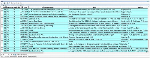
A particularly important entity from the historical point of view is the “Place names” entity: in fact, in this type of model, ancient toponyms must be recorded, taking into account all documented ancient place names, including information about ancient names of corresponding area districts and recording periods during which the names were in use. “Scientific studies” contains the data regarding relevant studies on the events, while “References” contains the data of known sources on which the studies of specific events are based and “Witness records” contains coeval observations and evidences on the seismic events. “Witness records” and “Scientific studies” share a relationship with “References”.
Finally, the “Witness routes” entity has been defined, to store information on itineraries followed by specific historical persons who left records on the events, and whose names are reported in the “Witness records” entity, therefore these two entities are connected by a relationship.
While designing the model, two issues have been taken into account:
to define an efficient model, with a simple and consistent structure, that can anyway be extended in case of future applications where new data or entities information should be incorporated;
to include in the model all information attainable from the considered seismic studies, particularly the data that may allow to derive estimates of seismic parameters, however, avoiding redundancies.
The model, in the form of an ERD, is shown in , where also the constraints cardinalities of the relationships are represented. In this case, cardinalities can be of the type 1:N (one-to-many), with the particular case 0:N, or N:N (many-to-many).
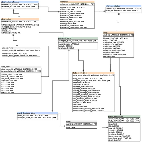
Subsequently, information represented in the ERD has been translated in a logical scheme efficiently describing the information content of the conceptual model. The data types, defined for all the attributes of the entities, are either integer, varchar or double. Then, besides defining primary keys for all entities of the database, foreign keys have been introduced to implement associations between entities with one-to-many cardinality (e.g. “Place_names” contains a foreign key corresponding to the primary key of “Damaged_places”). The logical model of the proposed database, designed by SQL Power Architect Community Edition, a Free and Open Source tool by SQL Power Group Inc., is represented in .
Figure 1. Conceptual model of the proposed relational database, represented as an Entity - Relationship Diagram (ERD); spatial entities are in grey boxes.
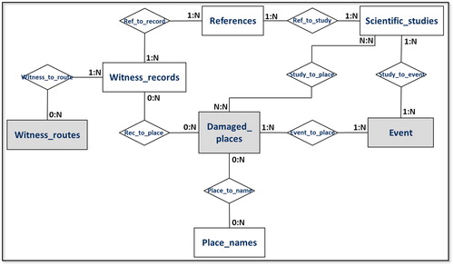
Figure 2. ERD including information of the logical model for the proposed data archive, designed using SQL Power Architect Community Edition. Green: georeferenced entities; orange: reference documents; light blue: junction tables (to implement the case of many-to-many relationships).
In order to make the logical scheme of the interpretation process understandable and to provide adequate documentation on the digital archive, a data dictionary has been drawn up as a part of the database metadata. In the data dictionary all entities are described, those georeferenced are clearly marked, and all attributes are listed with their meaning, format and data type. This information is essential and allows evaluating if the provided data are suitable for a specific application purpose.
A desirable feature of a GIS designed for historical research applications, is the possibility to superimpose the geographic representation of the data over a base map with cities and roads reproducing the state of the territory, as it was at the time of the seismic event. For the selected case study, it means using a base map coeval to the considered seismic events. For this application, it was possible to obtain and exploit two tiles of a map (Anonymous Citation1885) by the Militärgeographische Institut in Vienna, namely Tiles IV and VII of the General-Karte des KönigreichsGriechenland at 1:300.000 scale, available at the British Library in London. The map has been georeferenced with respect to the WGS84 reference system, using an affine transformation. As control points, locations visible both on the ancient and on the modern map have been identified. After the georeferencing operations, the average difference between positions in the ancient map and in the modern cartography were computed, the resulting value being about 3 km. This level of accuracy is adequate to the present case, taking into account the requirements of the GIS set by the historical seismologists.
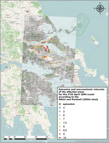
Overall, the data archived in the GIS allowed dynamically producing several maps showing the information from different points of view and, in addition, effectively comparing the results from the two considered studies. As an example, and show the spatial distribution of the macroseismic intensity assessed by the two studies at points covering the affected area, and the position of the epicentre for the event of 27th April 1894. By comparing the two maps, it is easy to observe that the more recent study by Albini and Pantosti (Citation2004) resulted in the estimation of a larger number of macroseismic intensities covering a much larger area with respect to the earlier study by Makropoulos and Kouskouna (Citation1994). A greater number of macroseismic data points together with a larger geographical coverage, leads to a much better constrained epicentre location and a more reliable magnitude estimation. The study by Albini and Pantosti (Citation2004) calculated these parameters by exploiting the Boxer method (Gasperini et al. Citation1999, Citation2010) using the macroseismic data points as input. The Boxer method proved to be a valid solution for this task, and it has been recently exploited for compiling the earthquake parameters of the Parametric Catalogue of Italian Earthquakes - CPTI15 (Rovida et al. Citation2016), that used as input the macroseismic data points contained in the Italian Macroseismic Database - DBMI15 (Locati et al. Citation2016).
Figure 3. Plot of the epicentre (star) and the macroseismic intensities (dots) related to the 27 April 1894 event according to the study by Makropoulos and Kouskouna (Citation1994). General-Karte des KönigreichsGriechenland © British Library Board.\
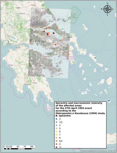
Figure 4. Plot of the epicentre (star) and the macroseismic intensities (dots) related to the 27 April 1894 event according to the study by Albini and Pantosti (Citation2004). General-Karte des KönigreichsGriechenland © British Library Board.
The GIS prototype helps keeping track of all researchers’ interpretations, together with an easy access to the considered historical data, all archived in a structured spatial database. Data organized in this way offer a convenient opportunity for creating an all-in-one solution enabling the future reappraisal of the earthquake, or whenever it would be necessary, to check each step of the interpretation workflow followed by the researchers.
A more complete description is required for the “Witness_routes” entity. The Albini and Pantosti (Citation2004) study collected data on the witnesses who reported the detailed effects of the events, related to a place and to a specific date. All these data associated to witnesses have been archived in the GIS database. An extensive description about the witnesses is of fundamental importance in historical seismology, as well as the possibility to follow their journeys on a map in a strict chronological order: these data can provide a valid hint on the reliability of the reported effect descriptions. In fact, a witness report is considered more reliable than indirect reports collected from somebody else while travelling, as in this case neither the place, nor the reported time can be fully trusted. In our case study the coeval witnesses are:
George I, king of Greece from 1863 to 1913;
Theodor Skouphos, Dr. of Natural Sciences, a Geologist from the University of Munich who had studied at the University of Athens;
William C. Bourchier (1852–1924), a naval chaplain of the Royal Navy.
From the geometrical point of view, the spatial entity “Witness_routes” had to be created by identifying the positions corresponding to the visited places in chronological order. The result is presented as a map in , showing the witnesses routes geo-referenced on the General-Karte des Königreichs Griechenland of 1885.
Figure 5. The witness routes geo-referenced on the General-Karte des Königreichs Griechenland, edited in 1885. General-Karte des KönigreichsGriechenland © British Library Board.
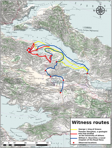
On the map, it is possible to see that all witnesses reached the affected area by sea. The first was George I, king of Greece, who disembarked in Livanates on 23rd April; later he continued by land and left Locris on 25th April, so he could not observe the event of 27th April. Bourchier was the second witness to reach the area on 24th April, going ashore in Kato Pelli, then he proceeded by land and he could observe the 27th April earthquake. T. Skouphos also reached the area in the same day as Bourchier, and he directly observed the earthquake of 27th April in Martino.
The historical macroseismic database was implemented and validated by means of a prototype based on the data extracted from the two seismological studies by Makropoulos and Kouskouna (Citation1994) and by Albini and Pantosti (Citation2004). Although the amount of information that can be obtained in this case study could be considered quite limited, it is nevertheless adequate and very useful for a proof-of-concept, demonstrating the feasibility of the adopted structure and its potential. In fact, various queries -including spatial ones- were run on the data within different GIS environments (e.g. Esri ArcGIS and QGIS), and the retrieved data and maps were checked and verified as being consistent with the considered studies.
Various types of queries can be performed on the database. For example, it is possible to retrieve the list of data sources considered by the available seismological studies on a specific event, as shown in for the earthquake of 20 April 1894. Another query example may be the list of historical data sources considered by a selected study, as shown in for the case from Albini and Pantosti (Citation2004).
Figure 6. Results of the selection of considered data sources by the two seismological studies performed on a specific earthquake, in the example the 20 April 1894, event in Locris.
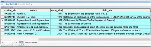
Figure 7. Results of the selection of considered data sources by a specific seismological study, that includes both previous seismological studies and historical sources, in this example the Albini and Pantosti (Citation2004) study.
Testing the publication of the historical earthquake GIS on the Internet
Nowadays, it is of fundamental importance to perform research work within a collaborative online and user-friendly environment. In fact, to fulfill the requirements of a modern data archive compliant to the Open Science (Nielsen Citation2011) paradigm, end users should be able to search and retrieve data using web services in an interoperable way. Interoperability and the extensive use of open standards are key factors in the European Research Area (Hoenig Citation2017), especially in the view of the upcoming European Open Science Cloud (Asmi et al. Citation2017; Candela et al. Citation2018), a strongly supported initiative by the European Commission. By implementing web services to access the data, it allows potentially any user to include the archived data in his workflow in a transparent way, no matter what type of software environment he has. This data sharing approach is adopted in the framework activities of EPOS, the biggest European Research Infrastructure Consortium (ERIC) in Earth-Science, where each data provider is requested to setup a web service following well-described guidelines matching specific international standards, such as the ones promoted by Open Geospatial Consortium (OGC).
To experiment a viable solution for online geodata sharing targeting both data creators (historians and historical seismologists) and final users (seismologist, engineers), we selected the Open Source web-based platform GeoNode (http://geonode.org/) sponsored by Open Source Geospatial (OSGeo Foundation) as it is becoming more and more popular in the Earth-Science research areas around the Globe (GFDRR Citation2017). As an example, GeoNode is the framework selected by the Global Earthquake Model foundation (GEM, https://www.globalquakemodel.org/) for developing their web platform. In addition, it was used by multiple European funded projects such as Increasing Resilience through Earth Observation (IncREO), and by the European Commission programme Copernicus for developing the “European Emergency Management Service” (Ajmar et al. Citation2015). The widespread use of GeoNode can be observed in conferences such as the FOSS4G (Free and Open Source Software for Geospatial), or by checking the GeoNode summits programs, where multiple examples of applications in the earth-observation and natural risk areas can be found. A very widely used alternative to GeoNode that could have been tested is the ESRI ArcGIS Online platform and their set of Web Mapping APIs. However, such a solution was excluded a priori because of its closed source nature, differently with respect to open source software where every aspect can be freely changed. Moreover, a solution like ArcGIS Online relies on third-party servers and services driven by for-profit goals. Instead, GeoNode is a platform mostly developed in Python and it is only based on the combination of various Open Source packages–most notably Django, PostgreSQL/PostGIS and Geoserver– blended in a coherent solution. In this platform, users are provided with a series of convenient OGC Web Services such as the Web Feature Services (WFS) or the Web Map Services (WMS) that well integrate in an OGC enabled GIS such as QGIS, and that are compliant with the interoperability guidelines for EPOS data providers (Bailo et al. Citation2018). With regards to the metadata, GeoNode relies on the software pycsw, an OGC Catalogue Service for the Web (CSW) able to deliver metadata compliant with the EN ISO 19115, 19119 and 19139 standards, the American Federal Geographic Data Committee (FGDC) Content Standard for Digital Geospatial Metadata (CSDGM) and the European Infrastructure for Spatial Information in Europe (INSPIRE) directives.
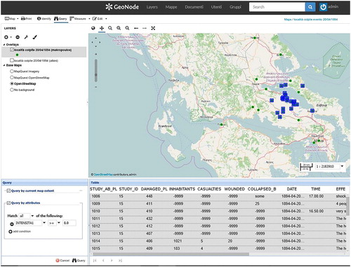
A test website was developed and published in a private network, to allow exploring the tasks that could be performed on the data and the level of performance of the selected framework. For example, users may investigate the online database to request complex queries such as “Identify all places damaged by the 20 April 1894 Locris event, and which were hit with intensity larger or equal to 8 (EMS-92), as it was reported in the Makropoulos and Kouskouna (Citation1994) study”. shows the user interface, which does not require any coding, where the output data answering the complex query are presented both as a selection of data records in a table and as a selection of points on the interactive map.
Figure 8. An example of results retrieved by a complex query on the database, as shown in a Web browser using the Open Source web-based GeoNode graphical user interface environment.
Of course, other queries can be performed on the database and have been tested in order to investigate e.g. the localities hit by the earthquake or the intensity and epoch of the events or other types of attributes such as places visited by witnesses, also combining different attributes in by using logical operators. As shown in the example in , the answers to the queries in the GeoNode environment will result both in a selection of the relevant records and in a map representing the results in a spatial form. It is interesting to remark that, since the historical names of localities have been recorded in the database together with the source where they have been cited, any query on the "Place names" will also result in the possibility to trace out differences in localities names and to check their sources.
Discussion and conclusion
A prototype GIS has been implemented with the aim of facilitating the archiving and management of macroseismic data together with all the underlying information sources considered in seismological studies on historical earthquakes. The final goal is to support the historical sources interpretation process performed by historical seismologists, as well as to obtain a future proof system for revising -and possibly enriching- past research. By using the developed prototype, historical data sources of on-going research can been stored and organized in the system, in addition to the data previously retrieved by earlier seismological studies, enabling the georeferencing of all data from the historical sources. Furthermore, the prototype GIS has been successfully tested in an online, private environment exploiting the Open Source GeoNode platform.
The prototype has been developed on the basis of a case study, focused on two seismic events occurred on the 20th and 27th April 1894, in Locris (Greece), which have been investigated by Makropoulos and Kouskouna (Citation1994) and by Albini and Pantosti (Citation2004).
The design of the database followed the well-known and well-established steps for the design of relational data base structures (ANSI-SPARC Citation1975). At first, the two above-mentioned seismological studies have been analyzed to define the typology and structure of the data, then, the conceptual model of the database has been designed, including spatial entities, historical sources, chronological path of the travelers that witnessed the effects of the earthquakes and as well as the bibliographical references. Subsequently, the logical model has been defined and the data dictionary has been drawn up. The database has been designed and populated using the Open Source software SQL Power Architect Community Edition and PostgreSQL/PostGIS. The system was first implemented using the Esri ArcGIS environment, and then it was re-implemented on the GeoNode platform based on PostgreSQL/PostGIS to allow for a more collaborative solution working on the Internet.
To provide a context basemap coeval to the events, the 1885 General-Karte des Königreichs Griechenland, at the scale of 1:300,000, has been georeferenced and included in the system. The implemented database allowed for the visualization and data query of the seismic events over the ancient map, as well as for the digitization of the routes followed by the witnesses found in the historical sources.
The developed prototype demonstrated the ability to address typical queries performed by the researchers involved in the field. Furthermore, it allowed for an investigation on new, potential queries and relations among the huge amount of retrieved historical data that, in the end, may facilitate the work of historical seismologists. Finally, this prototype casted a light on what the use of specifically developed GIS solutions may achieve in the exploitation of information buried in historical documents, and helped drafting the guidelines to what we will develop in the future. A particular aspect that will be explored in the future is the use of timelines, or any equivalent tool that allows the researcher to better investigate the evolution in time and space of natural phenomena like a seismic sequence. A preliminary investigation on the use of time-series enabled tools (e.g. ArcGIS Online, QGIS TimeManager, Geoserver) revealed that the time of the event is usually stored in a SQL database using a DATETIME type of fields, which is not suitable for historical events. In fact, a typical DBMS usually supports a time-range starting from “1000-01-01 00:00:00”, so any prior event cannot be considered. Another, more important issue with DATETIME, is that historical events may lack a very precise time because of incomplete or unreliable information, and this type of field requires being fully filled in order to work properly. In historical seismology it is indeed quite common not to have time associated to earthquakes, as well as a missing day or even month when the event occurred. Researchers working in this field continuously stress on the importance of avoiding filling in a missing information with numbers such as ‘01’, as it may erroneously end up associating an earthquake either to January, the first day of the month, or the first hour of the day. Not only this bad practice gives the false impression of a precise date when it is not the case, but it also may end up contributing in the duplication of earthquakes in a rather complicated scenario that researchers already struggle to keep clean from interpretation errors (e.g. Albini Citation2011). Therefore, the planned next steps will focus on how to structure a more complex and dynamic data archive, that would be able to reproduce the same level of detailed information analyzed in this article, but in a more realistic environment, characterized by a much larger geographical and time coverage.
Acknowledgements
The authors wish to thank Dr. Paola Albini from the Italian Istituto Nazionale di Geofisica e Vulcanologia (INGV) for her kind and professional contribution to the understanding of the topic. Thanks to her expertise in historical seismology, she helped us identifying a fitting use case scenario for developing our prototype, she extensively explained the relations among the considered seismological studies, and helped understanding the importance of the various types of data involved in this fascinating field of research. We thank the two anonymous reviewers whose comments helped improve the original manuscript.
Disclosure statement
No potential conflict of interest was reported by the authors.
Related Research Data
References
- Ajmar A, Boccardo P, Disabato F, Tonolo FG. 2015. Rapid mapping: geomatics role and research opportunities. Rendiconti Lincei. 26(1):63–73.
- Albini P. 2011. The true case of the 1276 fake earthquake. Seismol Res Lett. 82(1):111–114.
- Albini P, Pantosti D. 2004. The 20 and 27 April 1894 (Locris, Central Greece) earthquake sources through coeval records on macroseismic effects. Bull Seismol Soc Am 94(4):1305–1326.
- Anonymous. 1885. In: Militar KK, editor. Tables IV and VII of a general map of Greece. Vienna: Geografisches Institut. scale 1:300,000, (c) British Library Board.
- ANSI/X3/SPARC Study Group on Data Base Management Systems. 1975. Interim report. FDT, ACM SIGMOD Bulletin. Vol. 7, No. 2. New York: Ansi Inc
- Asmi A, Cordewener B, Goble C, Castelli D, Kühn E, Pasian F, Niccolucci F, Assante M, Dovey M, Manola N, et al. 2017. 1st Report on data interoperability: findability and interoperability. European Open Science (EOSC) Pilot, Deliverable 6.3. European Commission, Europa, EU.
- Bailo D, Paciello R, Rabissoni R, Sbarra M, Vinciarelli V. 2018. Integration of heterogeneous data, software and services in Solid Earth Sciences: the EPOS system design and roadmap for the building of Integrated Core Services. Rapporti Tecnici INGV. 393:22.
- Boschi E, Gasperini P, Smriglio G, Valensise G. 1996. The new "Catalogue of Strong Italian Earthquakes". Annal Geofis. 38(5–6):797–804.
- Buckland M, Lancaster LR. 2004. Combining time, place, and topic: The Electronic Cultural Atlas Initiative. D-Lib Mag. 10(5).
- Candela L, Castelli D, La Rocca G, Lukkarinen A, Manghi P, Pagano P, Papadopoulou E. 2018. Initial EOSC Service Architecture. EOSC Pilot, Deliverable 5.1. European Commission, Europa, EU.
- Carrion D, Maffeis A, Migliaccio F. 2009. A database oriented approach to GIS designing. Appl Geomatics 1:75–84.
- Carrion D, Migliaccio F, Minini G, Zambrano C. 2016. From historical documents to GIS: a spatial database for Medieval fiscal data in Southern Italy. Historical Methods J Quant Interdisciplinary History 49(1):1–10.
- Chen PP. 1976. The entity relationship model: toward a unified view of data. ACM Trans Database Syst 1(1):1–36.
- Codd EF. 1970. A relational model of data for large shared data banks. Commun ACM. 13(6):377–387.
- Cubellis E, Iannuzzi R, Luongo G, Obrizzo F. 2004. Management of historical seismic data using GIS: The island of Ischia (Southern Italy). Nat Hazards 33:379–393.
- DeBats DA, Gregory IN. 2011. Introduction to historical GIS and the study of urban history. Soc Sci History 35(4):455–463.
- Earth Science Europe. 2014. Pan-European Earth Science. Horizon 2020 project: Portal. Earth Sci Geol. 1:132–135.
- EC DG Research. 2014. Solid Earth observation, EPOS - European Plate Observing System. In: Global change: towards global research infrastructures. EU support for research infrastructures in environmental and Earth sciences. Brussel, Belgium: Directorate-General for Research and Innovation; p. 26–27. European Commission, Europa, EU
- Forlin P, Gerrard C, Petley D. 2016. Exploring representativeness and reliability for late medieval earthquakes in Europe, Nat Hazards 84:1625.
- Gasperini P, Bernardini F, Valensise G, Boschi E. 1999. Defining seismogenic sources from historical earthquake felt report. Bull Seism Soc Am. 89(1):94–110.
- Gasperini P, Vannucci G, Tripone D, Boschi E. 2010. The location and sizing of historical earthquakes using the attenuation of macroseismic intensity with distance. Bull Seismol Soc Am. 100(5A):2035–2066.
- GFDRR, Global Facility for Disaster Reduction and Recovery. 2017. Open data for resilience initiative & GeoNode: a case study on institutional investments in open source. Washington DC: GFDRR; p. 46.
- Godefroy P, Lambert J, Levret A, Vaskou P. 1990. The French macroseismic database 'SIRENE'. Proceedings of the 22nd General Assembly of the European Seismological Commission, Barcelona.
- Gregory IN, Geddes A. 2014. Introduction: from historical GIS to spatial humanities: deepening scholarship and broadening technology. In: Toward spatial humanities: historical GIS and spatial history. Bloomington, IN: Indiana University Press; p. ix–xxii.
- Grünthal G, editor. 1993. The European Macroseismic Scale 1992: up-dated MSK-scale. Cahiers du Centre Européen de Géodynamique et de Séismologie 7. Luxembourg: Centre Européen de Géodynamique et de Séismologie; p. 79.
- Grünthal G, editor. 1998. European Macroseismic Scale 1998. Cahiers du Centre Europèen de Gèodynamique et de Seismologie. Luxembourg: Conseil de l’Europe.
- Grünthal G, Wahlström R, Stromeyer D. 2013. The SHARE European Earthquake Catalogue (SHEEC) for the time period 1900-2006 and its comparison to the European-Mediterranean Earthquake Catalogue (EMEC). J Seismol. 17(4):1339–1344.
- Hoenig B, editor. 2017. Europe’s new scientific elite. London: Routledge; p. 216.
- Johnson I. 2004. Putting Time on the Map: Using Time Map for Map Animation and Web Delivery. GeoInformatics. 7(5):26–29.
- Johnson I, Wilson A. 2003. The Time Map Project: Developing Time-Based GIS Display for Cultural Data. Journal of GIS in Archaeology. 1:123–135
- Kouskouna V, Sakkas G. 2013. The University of Athens hellenic macroseismic database (HMDB.UoA): historical earthquakes. J Seismol. 17(4):1253–1280.
- Locati M, Camassi R, Rovida A, Ercolani E, Bernardini F, Castelli V, Caracciolo CH, Tertulliani A, Rossi A, Azzaro R, et al. 2016. DBMI15, the 2015 version of the Italian Macroseismic Database. Italy: Istituto Nazionale di Geofisica e Vulcanologia.
- Locati M, Rovida A, Albini P, Stucchi M. 2014. The AHEAD portal: a gateway to European historical earthquake data. Seismol Res Lett. 85:727–734.
- Makropoulos KC, Kouskouna V. 1994. The 1894 April 20 and 27 Atalanti earthquakes: 100 years after-lessons learnt. Proceedings of the XXIV ESC General Assembly, Sept 19–24, 1994; Athens (Greece); vol. 1:61–71.
- Musson RMW, Grünthal G, Stucchi M. 2010. The comparison of macroseismic intensity scales. J Seismol. 14:413–428.
- Nielsen M. 2011. Reinventing discovery: The new era of networked science. Princeton University Press; p. 280.
- Pessina V, Meroni F. 2009. A WebGis tool for seismic hazard scenarios and risk analysis. Soil Dynam Earthquake Eng 29(9):1274–1281.
- Postpischl D, Stucchi M, Bellani A. 1991. Some ideas for a databank of macroseismic data. Tectonophysics 193:215–223.
- Rovida A, Locati M, Camassi R, Lolli B, Gasperini P, editors. 2016. CPTI15, the 2015 version of the Parametric Catalogue of Italian Earthquakes. Italy: Istituto Nazionale di Geofisica e Vulcanologia.
- Stucchi M, Albini P. 1991. New developments in macroseismic investigation. Proceedings of the International Workshop “Seismology and Earthquake Engineering”, April 22–26; Mexico City, p. 47–69.
- Stucchi M, Rovida A, Gomez Capera AA, Alexandre P, Camelbeeck T, Demircioglu MB, Gasperini P, Kouskouna V, Musson RMW, Radulian M, et al. 2012. The SHARE European Earthquake Catalogue (SHEEC) 1000–1899. J Seismol. 17(2):523–544.