
Abstract
The increasingly intensive use of natural resources with consequent environmental impacts has generated numerous social conflicts over the years, for whose solution it is necessary to build up an innovative territorial governance model based on sustainable and resilience thinking. At the international level, the problems associated with oil and gas extraction activities have been tackled by recognizing scientific research as a strategic role aimed at guaranteeing a more in-depth knowledge of environmental issues, the creation of collaboration networks between the various stakeholders and the whole usability of environmental data. This article presents the commitment made by the National Research Council of Italy – Institute of Methodologies for Environmental Analysis – CNR-IMAA to make the Val d’Agri community, an area affected by mining activities, less vulnerable and more resilient. Through the combined use of different scientific research methodologies, a multidisciplinary approach was developed which contributed to increasing the overall knowledge of the environmental problems of Val d’Agri as well as providing concrete indications for the development of more effective territorial management tools. Other activities, complementary to those of research, were aimed at ensuring correct and detailed environmental data information and communication and a broaden participation and involvement of citizens.
1. Introduction
The complexity that characterizes the environmental-socio-economic system requires to build up an innovative territorial governance model. A truly holistic approach is needed to achieve sustainable development, according to the 17 Sustainable Development Goals (SDGs) adopted in 2030 Agenda (UN 2018), and to implement the resilience our societies deserve (Vella 2017). ‘Our common future’ report (WCED 1987) sensed the need to introduce more efficient and sustainable production models in the use of energy and resources, reducing pollution and minimizing risks to health and accidents. This represents an indispensable starting point and its objectives have given rise to the thought that underpins the circular economy. In a context of rapidly depleting resources, making the use of resources more efficient and sustainable, minimizing waste makes the EU more competitive and with greater possibilities for social integration and justice. A long-term sustainability provides full compliance with environmental legislation, and also to make its own wider challenges at the economic and social level. Also, all the smart city initiatives can support the achievement of the sustainable development by using Information and Communication Technologies and other means to improve the quality of life, efficiency of urban operation and services and competitiveness, while ensuring that it meets the needs of present and future generations with respect to economic, social, environmental as well as cultural aspects (UNU-EGU 2016; ITU 2018). In the perspective of building a vision to improve the quality of life of citizens and also for the future generations, smart cities should also be resilient. Climate change, natural disasters and environmental degradation are intertwined and often have a major impact on community resilience and on the ecological support systems on which life depends. In addition, they are already a cause or factors that contribute to the emergence of conflicts in the world. One of the most important challenges is represented by the task of broadening our approach by putting more emphasis on the conservation, restoration and sustainable management of natural resources and ecosystems and on the maintenance of the services they provide (Coluzzi et al. Citation2007; Imbrenda et al. Citation2013). In fact, the ecosystems that support agriculture and provide water, shelter and livelihood for local communities must be resilient. This means that to maintain sustainability, societies also need to manage resilience. This is the ability of an individual, a community or a country to cope, adapt and quickly recover from stress and shocks caused by a disaster, violence or conflict (EC Citation2018). According to the Sendai Framework for Disaster Risk Reduction (UNISDR 2015a), it is necessary to tackle disaster risk reduction and climate change adaption when setting the SDGs, particularly in light of an insufficient focus on risk reduction and resilience in the original Millennium Development Goals. The United Nations Office for Disaster Resilience – UNISDR has proposed new Ten Essentials for Making Cities Resilient (UNISDR 2015b; Panda and Amaratunga Citation2016), offering a comprehensive approach with the intention to enable cities establish a baseline measurement of their current level of disaster resilience, to identify priorities for investment and action and to track their progress in improving their disaster resilience over time. In particular, Folke et al. (Citation2015) and Biggs et al. (Citation2012) suggested seven principles that are considered crucial for building resilience in social–ecological systems. The seven principles are: (1) maintain diversity and redundancy, (2) manage connectivity, (3) manage slow variables and feedbacks, (4) foster complex adaptive systems thinking, (5) encourage learning, (6) broaden participation and (7) promote polycentric governance systems. Resilience can play a pivotal role in strategic planning, integrating resilience-based territorial governance and strategic environmental planning in urban development and social aspects (Moraci et al. Citation2018). To this aim, it is important to define policies and codes in order to integrate resilience-based land use and emergency planning in urban development and social aspects. The enhancement of risk management capabilities and the reduction of the social and environmental vulnerability can be achieved by bridging the gap between science, legal/policy issues and local knowledge, through seeking inputs from a large range of stakeholders (scientists, technical expert practicing in the relevant areas, decision makers and civil society) and therefore improving the combination of bottom-up and top-down knowledge and processes. According to Kelly et al. (Citation2015), resilience and vulnerability can be understood as a spectrum, that is that a resilient system always has ‘positive’ attributes, whereas a vulnerable system tends to be dominated by ‘negative’ attributes. This means that well-developed economic, institutional, social, cultural and natural domains are crucial for resilient communities. Based on a resilience–vulnerability spectrum, community resilience will be strongest at the intersection of these domains. It is necessary that administrators can control the pressures that threaten the ecosystem and its functionality, improve its effectiveness and build up an innovative territorial governance model, which also takes into account the costs of ecosystem services. In this framework, this study provides an exhaustive overview of the research activities carried out by the CNR-IMAA in order to help make the Val d’Agri community less vulnerable and more resilient.
2. The case study
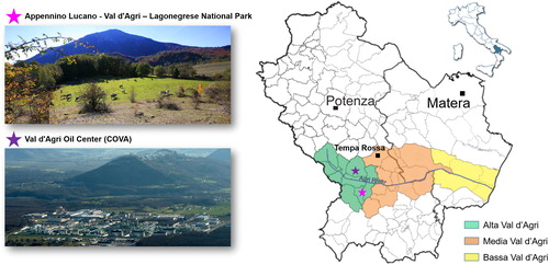
The Val d’Agri located in Basilicata Region (Southern Italy) is one of the largest intermontane basin (about 1700 km2) of southern Apennines situated along the 136 km long Agri River. The Val d’Agri is divided into three distinct sub-zones (Alta, Media and Bassa-High, Middle and Low) based on physical and environmental characteristics, socio-economic and demographic factors, and based on pattern of human settlements and land use (). In particular, the Alta Val d’Agri (hereinafter AVDA) hosts part of the Appennino Lucano – Val d’Agri – Lagonegrese National Park, the Pertusillo dam, which supplies since 1964 fresh water to several towns and cities of Basilicata and Apulia Regions, the Archeological Park of Grumento and the AVDA National Archeological Museum with Roman colonization remains, castles and middle-age villages, churches and relevant monastic complexes. This area is characterized by an ancient rural economy, based on agriculture and dairy production, and on cultural and naturalistic tourism, attracted by the environmental, historical and cultural resources of the territory. In the first half of the 20th century, near Tramutola town oil was discovered and in the early 1990s and the AVDA became the area hosting the biggest onshore oil and gas field in continental Europe. In the same period, the Italian Energy Hydrocarbons Eni S.p.A. corporation started the exploitation of the hydrocarbons. It is now operating in 26 oil wells (Mise 2018) and it is managing the Val d’Agri Oil Center (hereinafter COVA), that is the largest Italian gas and oil pre-treatment plant located in an anthropized area characterized by a significant environmental complexity. Also, more recently, the Total Company has started the exploitation of the Tempa Rossa oil field in the Media Val d’Agri ().
Figure 1. The localization of Basilicata region and Val d’Agri area with a zoom on the Appennino Lucano – Val d’Agri – Lagonegrese National Park and the COVA. Source: Google
The presence of extraction activities with high environmental impacts has affected the agricultural and tourist vocation of the valley (CDCA Citation2015).
Furthermore, almost 30 years after the beginning of the extractions, the impacts on local communities and territories have not been completely assessed yet. This situation has led to the loss of trust of citizens who have not been involved in the decision-making processes and who do not live their territory in safety. Till now, furthermore, social and environmental conflicts have been generated and both institutional and civil society’s reactions have been triggered. Soon after the first years of the drilling boom and related wealth expectations, citizens and social organizations started questioning the oil activity. In July 1996, the first major demonstration was organized by local decision makers worried about the lack of employment opportunities brought by Eni. (2014) was a year of new and strong mobilizations in Val d’Agri and in the entire Basilicata Region, following the decisions of the Law Decree ‘Sblocca Italia’ concerning the country’s extractive future and in particular for Basilicata, the region that produces more crude oil in Italy (CDCA Citation2015). To overcome these problems but also to increase the chances of socio-economic and cultural development of the entire community, there are two challenges to be faced: the sustainability and the resilience. In particular, by an application of the SLEUTH model to the Val d’Agri area, Amato et al. (Citation2016) affirm the dramatic importance of updated urban planning tools based on the principles aimed at reducing soil consumption to build up the resilience, and to guarantee the safeguarding of natural and environmental systems and the sustainable development of local communities. Besides that, and by the geolocation of the actions of the Open Coesione database, the authors demonstrate that most of the interventions are realized in total absence of an overall strategic framework able to relate its investments on the territory with the real needs of the people living in it.
3. Methods
In the period 2012–2014, the Basilicata Region funded an operational agreement with the CNR-IMAA aimed at supporting the implementation of the Val d’Agri Environmental Observatory (OAVDA). This was in line with the 1998 Eni commitments as an environmental compensation measure of the hydrocarbon extraction. On the basis of the obtained results, recognized by the international scientific community, which were able to identify some of the most significant environmental criticalities, in 2015 the Basilicata Region chose to finance a further research activity at the CNR-IMAA in order to guarantee the sustainable development of the communities affected by the hydrocarbon production activities. These challenges were addressed by recognizing the strategic role of research in building up a vision of community development, based on the aforementioned principles of sustainable development and resilience. Correlated to these (), two macro-operative strategies were individuated and faced by an innovative scientific and multidisciplinary approach in order to increase the environmental awareness of community about all the extractive process entails. The complexity of the system under study required the convergent contribution of several methods of analysis with the involvement and the collaboration of different professional figures (e.g. engineers for the environment and territory, geologists and physics) to overcome the disciplinary boundaries in a global systemic vision. This collaborative multidisciplinary was also experimented in identifying new fields of action by implementing the following two macro strategies.
Table 1. General information on strategies implemented by the CNR-IMAA.
In particular, a first strategy carried out by research activities and aimed to improve the existing understanding of the environmental issues and the second one by the so-called ‘complementary activities’ (complementary respect to the research ones). In the following, the methodological aspects of these two strategies are reported.
3.1. Research activities
The research activities were based on the development and the combined use of different methodologies aimed at carrying out:
a study of the local seismicity;
a study of the air quality;
satellite-based algorithms for gas-flaring analysis;
an environmental modelling.
3.1.1. Local seismicity
To understand the complex system of possible relationships between seismicity, seismogenic structures and anthropic activities in the AVDA, a multidisciplinary approach based on the joint application of different geological, geophysical and seismological techniques was carried out. In particular, the surficial investigations (e.g. field geological survey, etc.) allowed us to highlight the main geological and structural features. Different rectilinear scarps along the south-western slope of the AVDA were investigated. We carried out geological and geophysical investigations in order to verify the nature of each scarp observed at surface and to interpret it either as a tectonic landform (i.e. fault scarp) or as a geomorphic feature (i.e. erosional scarp) (Giocoli et al. Citation2008). In addition, when waveforms are available, we relocated the seismicity. This was the case for events collected by the Eni network (since 2002) and the ISIDe (2015) database (since April 2005). All the events collected by the Eni seismic network were relocated by using a 1D velocity model of the study area (Valoroso et al. Citation2009) and applying a non-linear global approach, implemented in the NonLinLoc software (Lomax et al. Citation2000). For specific clusters of seismicity (, areas A and B), we integrated the Eni data set with waveforms retrieved from the ISIDe database, and we performed a relative location of events by applying the double-difference technique (HypoDD code; Waldhauser and Ellsworth Citation2000). Relocated events were finally correlated with the reservoir parameters (Stabile et al. Citation2014a; Stabile et al. Citation2015; Telesca et al. Citation2015) and fluid–injection parameters (Stabile et al. Citation2014b).
Figure 2. The AVDA in Southern Italy with the indication of the two fault systems (EAFS and MMFS) and the location of recent seismicity (period, 2002–2012). The clusters A and B are reservoir-induced seismicity and fluid–injection-induced seismicity, respectively.
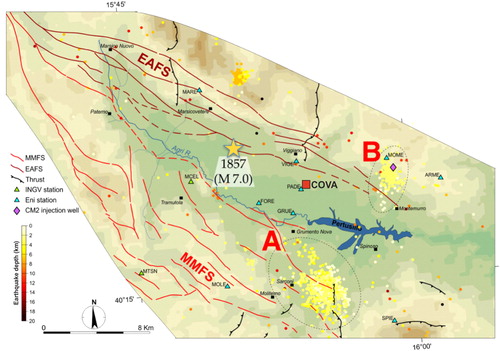
Overall, the joint analysis of the different data allowed us to (1) better understand the geological and structural setting, (2) characterize the time dynamics of observed seismicity and (3) image the geometry and architecture of the faults.
3.1.2. Air quality
In order to study the impact of the emissions of the COVA plant on the air quality of the surrounding area, particulate matter (PM) and gaseous pollutant measurements – recorded by the air-quality network of the Regional Agency for the Protection of the Environment of Basilicata (ARPAB) operating in AVDA or during dedicated experimental campaigns carried out by the CNR-IMAA in the area under study – were analyzed by advanced statistical techniques (e.g. singular spectral analysis and principal component analysis). In addition, complementary tools were used to evaluate the level of severity of the air pollution due to aerosol particles and to provide preliminary information about the levels of population exposure.
Moreover, due to the combustion processes occurring at the COVA, Black Carbon represents a key parameter to be studied to assess possible impacts of the plant on the air quality and related potential health risks on the population (Pavese et al. Citation2012). To this aim, a 2-year data set (2011–2013) of equivalent black carbon (EBC) measurements has been collected close to the COVA plant. The instrument used is a 7-wavelength Magee Scientific aethalometer AE31 (370, 470, 520, 590, 660, 880 and 950 nm) that measures the attenuation of light by the absorbing particles collected on a quartz fibre filter. The instrument also allowed the detection of the organic fraction presence through the UVPM (UV-absorbing PM) quantity (Esposito et al. Citation2012). The data of equivalent black carbon were analyzed on a long-term basis and then compared with temporal variations of the main meteorological parameters, benzene, toluene and methane concentrations measured by ARPAB, and PM10 loading at the site.
3.1.3. Satellite remote sensing
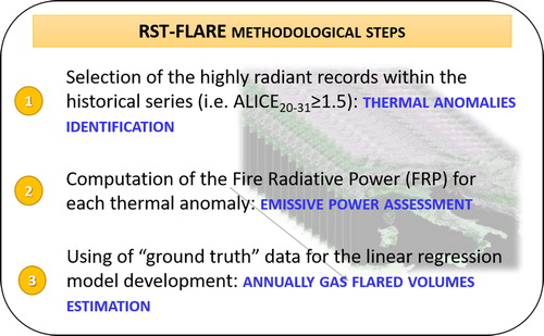
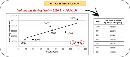
Gas flaring is a process widely used for the disposal of natural gas produced at oil and gas facilities, recognized as a waste of a valuable non-renewable source of clean energy, contributing to global warming, causing climate change and greatly impacting human, the environment and the economy (Giwa et al. Citation2017). For its impacts acquiring transparent and updated information on gas flaring is of global and local concern (Faruolo et al. Citation2018). In the last decade, satellite-based methodologies have been developed in order to bridge the gap between such a need and the lack of reliable data about gas flaring, in terms of flaring sites localization and amount of flared gas emitted into the atmosphere. Faruolo et al. (Citation2014) carried out the first investigation of the COVA gas flaring, by satellite observations, providing a comprehensive analysis of the source, from its thermal characterization to the estimation of gas-flared volumes. At COVA, the most of gas is recovered, being the industrial process regulated by strict regional laws (Eni 2014) and a minimum amount is burned off, mainly in emergency conditions (i.e. waste flaring) when the flares system acts as a safety device. For such a reason, the COVA is a source characterized by low/moderate emission rates (less than one million of cubic meters per year), when compared with the ones located in countries like Nigeria or Russia (burning off several billion of cubic meters per year) (Faruolo et al. Citation2018). Recently, the Robust Satellite Techniques (RST)-FLARE algorithm was developed to infer quantitative information on COVA gas flaring (Faruolo et al. Citation2014). Following the general prescriptions of the RST approach (Tramutoli Citation2005, Citation2007), a change detection scheme based on the processing of multi-year time series of satellite images, collected in homogeneous observational conditions (e.g. same geographic area, same month and hour of acquisitions), RST-FLARE allowed to: (i) select the highly radiant records (compared to the normal behaviour of the plant), which can be associated to the COVA flares emergency discharges; (ii) quantify the emissive power of the COVA by a satellite metric, named Fire Radiative Power (FRP, Kaufman et al. Citation1998); (iii) compute, by means of a linear regression model, the volumes of gas annually flared at COVA site in emergency conditions ().
Figure 3. A simplified scheme of RST-FLARE methodological steps.
3.1.4. Environmental modelling
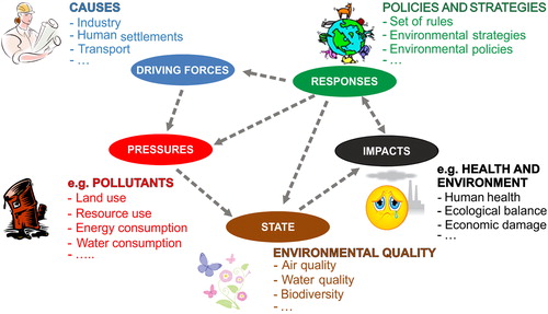
This research activity was aimed to implement the environmental balance of the AVDA industrial area by utilizing the Driving Forces–Pressures–State–Impact–Responses (DPSIR) model in order to provide stakeholders with a comprehensive analysis that focuses on the existing data, the main sources of pollution, their potential impacts and the policy strategies (Cosmi et al. Citation2006; Loperte and Cosmi Citation2015). For its assessments of the relationships between the human activities and the environment, European Environmental Agency (EEA) uses an extended version of the previous model, called Pressure–State–Response (PSR) framework, and developed by Organization for Economic Co-operation and Development, which is the DPSIR framework (OECD Citation2003). Assuming a chain of causality (, arrows), social and economic developments exert pressure on the environment and, as a consequence, the state of the environment changes. This leads to impacts on, for example, human health, ecosystems and materials that may elicit a societal response that feeds back on the driving forces, on the pressures or on the state or impacts directly, through adaptation or curative action. This model describes a dynamic situation, with attention for the various feedbacks in the system. Following the guidelines of the EEA and the Istituto Superiore per la Protezione Ambientale, specific indicators were selected according to the peculiarities of the system under analysis and the availability of data. Through a survey methodology, it was possible to collect all the data necessary for the economic matrix construction for the characterization of environmental pressures in terms of land use, natural resources use, energy production and consumption (energy balance), waste production (with a focus on hazardous special ones) and atmospheric emissions. Besides this, a punctual check of all the existing data on the state of the environment of the various environmental matrices was carried out together with the response measures aimed to compensate the environmental impact of human activities as well as to guarantee adequate life conditions and information to the population.
Figure 4. The DPSIR methodology framework applied to the AVDA industrial area.
3.2. The complementary activities
‘Communicate the environment’ is an argued challenge at guaranteeing the accountability of the public administrations that are to be transparent, explain and motivate choices, assign the responsibilities correctly. The researchers often think first of all to explain the uncertainties between environmental exposure and disease and stop at that. It is necessary, instead, to start from a broader examination able to understand the reasons of some choices, regarding, for example, some technologies and not others, and which are the needs and the associated problems. The communication is to circulate facts, ideas and promote the contamination of knowledge by mixing skills. To this aim, the research community with its scientific rigor and transparency criteria can support the comparison among different stakeholders, recognizing the different roles in the processes of information (one way), communication (bidirectional and interactive) and participation (which provides actions and decision making on the merits of the issues).
3.2.1. Collection and organization of environmental data and of projects and studies on Val d’Agri
A first activity was carried out in order to collect and manage the monitoring data transmitted by Eni to the Basilicata Region. These data were the official ones provided by the Environmental Monitoring Plan, whose implementation was established by an operating protocol between the ARPAB and the Eni company in 2011 in compliance with the DD.GG.RR. 313/2011 and 627/2011().
Table 2. Summary of the main information regarding the Official Environmental Monitoring Plan (DD.GG.RR. 313/2011 and 627/2011).
Besides this, also a database of the AVDA seismicity was implemented and populated by collecting data from different catalogues of the historical and recent Italian seismicity since 1759 (Stabile et al. Citation2015):
CPTI (from 1759 to 1981): Catalogo Parametrico dei Terremoti Italiani [Gasperini et al. Citation2004 (CPTI04); Rovida et al. Citation2011 (CPTI11)];
CSI (2015) 1.1 (from 1981 to 2002): Catalogo della Sismicità Italiana (CSI 1.1, http://csi.rm.ingv.it);
BSI (from 2002 to 2005): Bollettino Sismico Italiano (Citation2015) (http://bollettinosismico.rm.ingv.it);
Eni (from 2002 to 2014): Database of the micro-seismic network managed by the Eni company (Stabile et al. Citation2014a,Citationb);
ISIDe (from 2005 to 2014): Italian Seismological Instrumental and parametric database (http://iside.rm.ingv.it/iside).
Furthermore, databases of hydrometric data of the Pertusillo reservoir since its impoundment (October 1963), provided by the Ente per lo Sviluppo dell’Irrigazione e la Trasformazione Fondiaria, Agency of Potenza (Stabile et al. Citation2014a), and fluid–injection data of the Costa Molina 2 (hereinafter CM2) injection well since the beginning of the injection activities (June 2, 2006), provided by the Basilicata Region (Stabile et al. Citation2014b), had been implemented.
Another important activity carried out was the upgrade of the Register of the projects and/or studies developed in the last years on Val d’Agri area. Together with the Basilicata Biomedical Research Foundation, the CNR-IMAA worked on the implementation of methodological guidelines to integrate the existing information with a focus on the scientific publications, the organized scientific seminars as well as on volumes and dissemination reports. In order to get an exhaustive framework of the scientific publications regarding the Val d’Agri area, the references were the Web of Science (WOS Citation2016) multidisciplinary bibliographic/citational platform and the Elsevier’s Scopus, the largest abstract and citation database of peer-reviewed literature (Scopus Citation2016). ‘Val d’Agri’ and ‘Agri Valley’ keywords were chosen as search criteria and all available years were considered.
3.2.2. Information of environmental data
One of the most significant steps in the development of an innovative platform to inform citizens was the implementation of data-transfer protocols among different Institutions. According to the availability of existing data, a lot of efforts were provided in order to manage the transfer of seismic data between Eni and the OAVDA and of air quality data between the ARPAB and the same Observatory. These activities were preliminary and necessary for subsequent development of the environmental reporting. Contextually to these activities, and in order to guarantee a better, more effective and transparent information of environmental data, scientific support was given to develop the architecture of the website of the OAVDA (http://www.osservatoriovaldagri.it/). A smart community must also be able to count on innovative tools of disseminating environmental data considered to be of greater interest to the population in order to increase the environmental awareness and the involvement of citizens. To this aim, scientific support was given in order to develop an application (hereafter referred to as ‘app’) for smartphones and tablets too.
3.2.3. Dissemination of scientific outcomes
The effective communication and dissemination of environmental issues are important to pursue the goal of sustainability and resilience of a community. In this direction, the CNR-IMAA decided to be the promoter of numerous opportunities for comparison and growth of the community. The organizational structure of each seminar provided in-depth studies by internationally renowned scientists and the participation, through a public debate, of all the stakeholders. In order to maximize communication effectiveness and to pursue the broadest participation of citizens, particular attention was paid to the translation in Italian language and the Open access. This last was used to each talk, which can be downloaded or visualized as video or as printable presentation from the OAVDA website.
3.2.4. Development of educational programmes
In addition to information activities, it was also considered important to develop an educational programme relative to environmental sustainability and pollution problems. The program, titled ‘INFORMATECI: INformazione e FORMazione Ambientale del TErritorio e dei CIttadini della Val D’Agri’ on the environmental information and education of the Val d’Agri territory and citizens, intended to have a value that was not only informative but also educational, providing for meetings, acquisition of skills and knowledge and local actions. It wanted integrating and being in synergy with other regional policies and those of other institutions operating in the territory, taking into account the environmental and sustainable local development priorities. In order to achieve the widest participation of all the various stakeholders, also including the entrepreneurs, a number of program agreements were planned.
To take into account the specific priorities of the territory, the following lines of intervention were structured:
actions for the territory/citizenship/scientific community;
actions for high school level.
The aforementioned actions were complementary with each other, having educational and awareness-raising effects not only for the citizens of the territory directly involved in the initiatives (school children, teachers, public employees and administrators) but also, through them, their families.
3.2.5. Scientific workshop on Citizens’ Observatory and air-quality perception survey for schools
In order to involve citizens in the assessments of air and environmental quality to empower them to actively participate in environmental governance, a specific workshop was dedicated to the Citizens’ Observatories. They are community-based environmental monitoring and information systems. By using innovative Earth observation applications embedded in portable or mobile personal devices, citizens can support and be engaged in observing the environment. In view of a possible future realization of a Citizens Observatory (EC Citation2016) also in Val d’Agri, an air-quality perception survey was conducted involving some students of a secondary school. The format of the questionnaire was that of the EU CITI-SENSE Project, Citation2012 (www.citi-sense.eu).
4. Results and discussion
4.1. Overview of the most important scientific results
In the following, the most important results of scientific research are reported.
4.1.1. Local seismicity
The AVDA is a Quaternary NW–SE trending inter-montane basin located in the axial zone of the Southern Apennines thrust belt chain (Southern Italy) () and it is one of the areas of Italy with the highest seismogenic potential as the seismogenic normal fault system of the valley is capable of generating up to magnitude seven earthquakes (i.e. the M7, 1857 Basilicata earthquake). Indeed, according to the Italian seismic regulation, seismic hazard in this test site is very relevant, with an expected maximum acceleration for an exceedance probability of 10% in 50 years within 0.25 and 0.275 g. The seismogenic structure capable of producing large events is alternatively associated with: (1) the Monti della Maddalena Fault System (MMFS) and (2) the Eastern Agri Fault System (EAFS). The joint application of geological, seismological and geophysical techniques was used to investigate both MMFS and EAFS (). Seismic risk is amplified by the presence of two important human activities related to energy technologies: (1) the exploitation of the largest productive on-shore oil field in west Europe, managed by the Eni company, which produces about 82,000 barrels of oil per day and 3.4 million cubic meter of gas per day and (2) the artificial Pertusillo water reservoir, with a capacity of 155 million cubic meters filled behind a dam of 95 m height. In particular, the accurate location of seismic events since January 2002 and the correlation analyses with reservoir data and fluid–injection data allowed us to classify two clusters of seismicity located near the Pertusillo artificial lake as induced events (). Cluster A is continued-reservoir induced seismicity (Ml ≤2.7) due to the seasonal water level fluctuation of the Pertusillo water reservoir (Stabile et al. Citation2014a; Stabile et al. Citation2015; Telesca et al. Citation2015; Serlenga and Stabile Citation2018); seismicity occurs mainly between March and July of each year and it is widespread into a small volume at the southern termination of the MMFS. Cluster B is fluid–injection-induced seismicity (Ml ≤2.0) due to the disposal at the CM2 injection well of the wastewater produced during the exploitation of the biggest onshore oil and gas field in west Europe (managed by Eni Company); the onset of micro-earthquakes was observed only after the beginning of the wastewater disposal (June 2, 2006) and the seismic cluster is located at about 1.3 km SW of CM2 injection well along a NE dipping, N310° trending fault that represents a southern strand of the EAFS (Stabile et al. Citation2014b; Giocoli et al. Citation2015; Serlenga and Stabile Citation2018). This was the first case of fluid–injection-induced seismicity by wastewater disposal documented in Italy.
4.1.2. Air quality
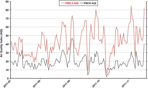
In order to study the impact of the emissions of the COVA plant on the air quality of the surrounding area, PM in-situ measurements were taken into account. Starting from statistical analyses of simultaneous daily mass concentrations of PM10, PM2.5 and PM1 (i.e. aerosol particles with aerodynamic diameter <10, 2.5 and 1 μm, respectively) and daily particle number concentration recorded by the ARPAB close to the COVA plant during a field campaign (July–November 2011), the predominance of fine and sub-micrometric PM fractions of anthropogenic origin was observed in the area under study. In addition, the calculation of the Air Quality Index (AQI) referred both to PM10 and to PM2.5 showed that the air quality was ‘moderate’ with respect to PM2.5 (), suggesting that fine particles, if they will be not kept under control, could represent a real problem, also posing health risks to the population living close to the COVA plant (Trippetta et al. Citation2013). As a consequence, a PM1 short-term monitoring campaign was carried out by the CNR-IMAA in Viggiano (40°20′8.59″N, 15°54′7.43″E) – the nearest town to the COVA plant and one of the most populated towns of the Val d’Agri area – in September 2012. The statistical analysis of the PM1 concentration and its chemical composition allowed the identification of the main PM1 sources that also included secondary atmospheric reactions involving COVA plant emissions and local soil particles (Trippetta et al. Citation2014). During this period, a gas-flaring episode due to a malfunction of the COVA plant occurred. The study of the PM1 geochemical and mineralogical features before, during and immediately after this episode highlighted the influence of the COVA emissions on the PM1 collected in terms of soot and S-rich particle as well as the significant role played by a Saharan dust event occurred during the gas flaring episode in supplying geogenic aerosol components to the PM1 (Margiotta et al. Citation2015). The influence of the COVA plant emissions on the air quality of the area under study was also confirmed by the results obtained by statistically analyzing the atmospheric concentrations of 17 trace elements (Al, Ca, Cd, Cr, Cu, Fe, K, Li, Mg, Mn, Na, Ni, P, Pb, S, Ti and Zn) measured at 59 biomonitoring stations installed by the CNR-IMAA and covering an area of about 100 km2 around the COVA plant (Caggiano et al. Citation2015). Finally, a novel approach based on the integration of gaseous pollutants and PM measurements from the ARPAB air quality network and additional CNR-IMAA experimental measurements (i.e. PM1 and black carbon) recorded in AVDA area from 1 September to 31 October 2013 with advanced statistical analyses highlighted that the COVA plant emissions have an impact on the air quality over the entire area. These impacts were mainly found in the area closest to this plant (Calvello et al. Citation2014).
Figure 5. PM10 and PM2.5 AQI values calculated from July to November 2011. The grey line indicates the break AQI value between ‘good’ and ‘moderate’ air-quality conditions (from Trippetta et al. Citation2013). Source: Elsevier
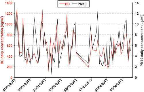
As regards EBC temporal patterns, a main industrial origin was assessed for this component with the addition of a background contribution due to traffic (Calvello et al. Citation2015). The EBC was found to represent a non-negligible contribution (about 10%) to the total PM10 loading at the site (). Finally, a good agreement was found when comparing UVPM temporal trends and concentrations of benzene, toluene and methane measured at the site.
Figure 6. Time series of EBC and PM10 mean daily values for the period January–April 2013. The corresponding scatter plot is reported in the upper right corner.
4.1.3. Satellite remote sensing
The RST-FLARE algorithm was recently developed to analyze the gas-flaring phenomenon, both in terms of flaring sites detection and in terms of volumes of gas annually flared (Faruolo et al. Citation2014, Citation2018). In , simplified scheme of the RST-FLARE methodological steps is reported. In its first configuration (Faruolo et al. Citation2014, ), ad hoc calibrated for the COVA plant, the algorithm, by processing nighttime infrared imagery, acquired by MODIS (Moderate Resolution Imaging Spectroradiometer) sensor in years 2000–2012, allowed to compute the amount of gas annually flared at COVA site, by means of a linear regression model. Two parameters are required for the calibration of the model: a diagnostic parameter aimed at quantifying the emission power of the source and official data on volumes of gas flared. Faruolo et al. (Citation2014) selected the FRP as the best suitable indicator of gas-flaring activity. Coupling the official data provided by Eni between 2003 and 2009 with the FRPs values computed for COVA, in the same temporal period, the algorithm furnished the volumes of gas annually burned off by such a source, mainly in emergency conditions. The achieved outcomes showed a good level of accuracy (R2 ∼ 80%), providing independent estimates of such volumes with a mean bias <2% (Faruolo et al. Citation2014). shows the scatterplot of the generated model and the estimates of flared volumes it provided (independently from ENI data) for COVA in years 2009–2015.
Figure 7. The RST-FLARE output for COVA site.
In the next future, with reference to COVA, detailed analyses will be conducted to jointly explore the developed satellite product and air-quality data (such as the Black Carbon or other pollutants concentrations, provided by air-quality studies) in order to determine if there is any relationship between them and with flaring events occurrence. This step will serve to verify the feasibility of an integrated analysis of the satellite indicator with independent air-quality measurements in order to evaluate its applicability as a proxy for the air quality around the COVA.
4.1.4. Environmental modelling
The application of the DPSIR methodology allowed to build up a preliminary environmental balance of the AVDA industrial area (Loperte and Cosmi Citation2015). This work provided a sound reference framework of the socio-economic and energy–environmental characteristics of the anthropogenic activities established in the area and to start a systematic collection of very useful data also for further investigations. It allowed a preliminary analysis of the environmental state of the air and water matrices and the check of the real availability of data. The implementation of the environmental balance also allowed the analysis of the strategies and policies implemented or planned by public bodies aimed at improving, controlling and managing the environment. It was not possible to assess the environmental impacts due to the activities of the AVDA industrial settlement because it was not possible to assess the changes of the state of environment. This is for two fundamental reasons: the unavailability of significant validated time series for the environmental data received from the official environmental monitoring and in the meantime the absence of studies and reports on the ex-ante environmental status before the start of oil/gas extraction activities in Val d’Agri.
4.2. An overview of the most important results of the complementary activities
4.2.1. Collection and organization of environmental data and of projects and studies on Val d’Agri
As concerns the data on air quality, a first activity was conducted in order to collect and organize the ones transmitted by Eni to the Basilicata Region for the period between April 2010 and November 2011. A first result was a structured database, made by Excel sheets that can be queried both for pollutants and for monitoring stations.
For what concerns the reconstruction of the catalog of historical and recent seismic data, it was possible to obtain the following results.
From 1759 to 1981, only historical seismicity information is available [Gasperini et al. Citation2004 (CPTI04); Rovida et al. Citation2011 (CPTI11)], indicating the occurrence in the AVDA of one event with Mw ≥ 5.0 (the 1857 Mw 7.0 Basilicata earthquake) and seven events with Mw ≥4.5. From 1981 to 1985 only one event with local magnitude Ml =2.6 has been reported in the catalogues of the AVDA. After January 1986, the AVDA is characterized by low-to-moderate seismicity (Ml ≤3.6). The estimated magnitude of completeness is Mc =2.4 ± 0.4 from January 1986 to December 2001 and Mc =1.2 ± 0.1 after January 2002 (Stabile et al. Citation2015).
As regards the upgrade of the Register of projects and/or studies on Val d’Agri, integrating the results obtained by the two keywords research and verifying the full relevance of the issue of the articles with the area under study, 136 scientific articles from 2016 to 1979 were individuated. In Excel files, the main information regarding the authors, title, keywords, reference environmental matrix, name of the magazine, number of pages, year of publication, DOI or ISBN, type of scientific product, language and access, open or paid were also reported in tabular forms (). Finally, also the most important information regarding the environmental reporting was collected in a tabular form including the title, the year of publication, the names of authors and the organizing public body. For what concerns the environmental reporting, summarizes the most important information. In particular, synthetic reports were prepared on relevant events occurred at the COVA plant and related to air quality, object of publication on the website of the OAVDA (http://www.osservatoriovaldagri.it/web/guest/).
Table 3. The list of the main information of the 136 scientific publications from 2016 to 1979 collected by the CNR-IMAA.
Table 4. List of the nine scientific seminars organized by the CNR-IMAA.
In detail, a report on air quality was implemented and one on the highest visibility events occurred at the COVA plant on 13 January 2014 (http://www.osservatoriovaldagri.it/FOCUS/13gen14_ENI_torcia_COVA/Studio_evento_13gen_2014.pdf). This study aimed at investigating the highest visibility event of the COVA through various innovative methodological tools, typical of research. These are able to provide information, heterogeneous from one another and peculiar to each area of investigation, to be managed in an organic way in order to obtain a broader and more detailed picture of the event under analysis and the possible impacts that can be related to it. Specifically, the methodological approach adopted was based on the combined use of satellite-monitoring methods, air quality and seismic.
4.2.2. Information of environmental data
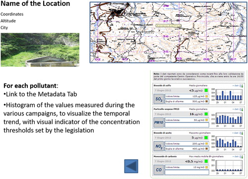
As concerns the implementation of the website, in addition to the dissemination contents (), specific sections were devoted to the information of environmental data received from the environmental monitoring of different matrices (air/water/soil quality, seismicity, etc.). Furthermore, for all the monitored pollutants, metadata cards were specifically created and to allow the display of monitoring data, different online browsing methods were implemented ().
Figure 8. Capture of a page of the OAVDA website. Source: Osservatorio Ambientale della Val d'Agri
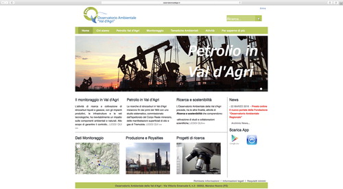
Figure 9. Capture of one of the possible visualizations of the environmental data. Source: Osservatorio Ambientale della Val d'Agri
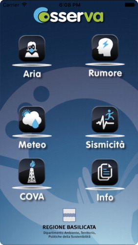
For a smart information on environmental data, the ‘OsserVA’ app for smartphone and tablet () was developed through which the concentration data of the main atmospheric pollutants (carbon monoxide, CO; sulphur dioxide, SO2, ‘coarse’, PM10 and ‘fine’, PM2.5 atmospheric particulate, hydrogen sulfide, H2S and non-methane hydrocarbons) and the main meteorological parameters (temperature, relative humidity, pressure, direction and speed of wind, precipitation and global radiation) registered at the five ARPAB monitoring stations present in the territory of the AVDA were made available in near real time. This ‘app’ also allowed information on the noise levels recorded at four measurement stations of which two are located near the COVA and the remaining ones in the two closest population centers: Viggiano and Grumento Nova, as well as on the occurrence of any seismic and micro-seismic phenomena occurring in the area involved in the hydrocarbons exploitation and news about production (e.g. last daily production of barrels and total barrels from 1 January 2013) or considered of particular interest (e.g. publication of reports and/or technical notes on the site of the OAVDA, scientific seminars, etc.).
Figure 10. Capture of the OsserVA app. Source: Osservatorio Ambientale della Val d'Agri
4.2.3. Dissemination of scientific outcomes
In the period from March 2013 to December 2016, as many as nine scientific seminars on the environmental issues of Val d’Agri were organized with the purpose of disseminating the results of research activities to citizenship. All the information regarding these events were reported in the same form, specifying the organizing public body, the title of the event, the date of execution, the venue, the titles of the showed presentations and the names of present speakers. reports a summary of these information.
Table 5. List of the five technical reports developed by the CNR-IMAA.
4.2.4. Scientific workshop on Citizens’ Observatory and air-quality perception survey for schools
As already said, in the perspective of building a Citizens’ Observatory also in Val d’Agri and wanting to enhance the profitable comparison with speakers of international caliber, in the context of the seminar dedicated to this topic, an air-quality perception survey was conducted.
With regard to this, as a statistically significant number of completed questionnaires was not reached, in the following only some preliminary indications are provided. Generally speaking, most of the interviewees considered really important to guarantee the maximum transparency in the information on environmental data. Most of the responses underlined the use of innovative information tools (e.g. app) as well as the desire to be increasingly involved in initiatives developed also by the support of scientific research. These preliminary indications are placed in the same direction as the results of the questionnaire carried out by the Institute of Clinical Physiology of the CNR of Pisa, which investigated the local perception of risk and information needs.
According to this, 87.5% of respondents believe that COVA represents a health risk and that there is not much trust on information, especially by local institutions and mass-media (Carra Citation2017).
5. Conclusions
The growth of the environmental awareness, the involvement of the citizens and a broaden participation of the community represent the direction toward which to aim to build a less vulnerable and more resilient community. Engaging local communities in the territorial governance model is vital in building a society that can sustain resilience consistently (Moraci et al. Citation2018). The goal of both sustainable and resilient development of a complex territory, like that of Val d’Agri, requires the implementation of an innovative territorial governance model, in which the role of scientific research is essential and strategic. This is also confirmed by the analysis of the international scenario.
The United States and the Northern Europe, for example, by virtue of the considerable size of mining activities and significant environmental sensitivity, can be configured as examples of best practices with their know-how, expertise and technological innovation.
In terms of policy, their research institutes and universities are constantly and actively involved in all the characteristic areas of the Oil & Gas sector. In the framework of the environmental protection, by a structured and long-term planning that also involves government bodies, oil companies and various other stakeholders (e.g. environmental organizations, citizens, etc.).
With reference to numerous international research programs, among which those of the Environmental Protection Agency of the USA and of the Norwegian Petroleum Directorate, it can be highlighted that the key elements of the research activity consist of a close synergy among the stakeholders and the guarantee of the full data usability: namely, research and technological development in support of an optimal management of resources in an environmentally sustainable context.
The main innovations of the activities described in this article can be summarized as follows:
the multidisciplinary approach of the research activities that has triggered a virtuous mechanism of exchange of environmental data and information and a know-how transfer, a contamination of knowledge that is useful and necessary for the analysis of a complex system like that of the Val d’Agri;
the application of the scientific method, based on rigor and transparency criteria, in supporting the complementary activities, guaranteed the possibility to provide detailed information and reporting as well as to implement networks and data-transfer protocols in full compliance with the Aarhus Convention (http://ec.europa.eu/environment/aarhus/index.htm).
This experience represented a first significant attempt in the Basilicata Region to directly involve research in building up a territorial governance model of the problems related to the hydrocarbon exploitation of the Val d’Agri.
Certainly much more is to be improved and realized in order to recover citizens’ trust and bridge the gap between science, legal/policy issues and local knowledge.
The CNR-IMAA, also thanks to this experience in Val d’Agri, will work further to increase its skills in order to make them increasingly able to successfully face the challenges of sustainability and resilience for a less vulnerable society.
Acknowledgements
The authors sincerely thank Vincenzo Lapenna – Director of the National Research Council of Italy – Institute of Methodologies for Environmental Analysis – CNR-IMAA and Donato Viggiano – General Director of the Department of the Environment, Territory, Sustainability policies of the Basilicata Region, for having given them the opportunity to face the compelling challenge of the Val d’Agri with their desire for knowledge. They also show their deep gratitude to Lucia Possidente and Maria Marino for having coped with this challenge together! The CNR-IMAA colleagues R. Caggiano, C. Cosmi, G. Pavese, N. Pergola, A. Perrone, S. Piscitelli, V. Summa. are gratefully acknowledged for their scientific support.
Disclosure statement
No potential conflict of interest was reported by the authors.
Additional information
Funding
References
- Amato F, Maimone BA, Martellozzo F, Nolè G, Murgante B. 2016. The effects of Urban policies on the development of urban areas. Sustainability. 8(4):297. doi: 10.3390/su8040297. Available at www.mdpi.com/journal/sustainability (06/18/2018).
- Biggs R, Schluter M, Biggs D, Bohensky EL, Silver SB, Cundill G, Dakos V, Daw TM, Evans LS, Kotschy K, et al. 2012. West toward principles for enhancing the resilience of ecosystem services. Annu Rev Environ Res. 37(1):421–448.
- Bollettino Sismico Italiano. 2015. Available at http://bollettinosismico.rm.ingv.it.
- Caggiano R, Trippetta S, Sabia S. 2015. Assessment of atmospheric trace element concentrations by lichen-bag near an oil/gas pre-treatment plant in the Agri Valley (Southern Italy). Nat Hazards Earth Syst Sci. 15(2):325–333. doi: 10.5194/nhess-15-325-2015.
- Calvello M, Esposito F, Lorusso M, Pavese G. 2015. A two-year database of BC measurements at the biggest European crude oil pre-treatment plant: a comparison with organic gaseous compounds and PM10 loading. Atmos Res. 164–165:156–166.
- Calvello M, Trippetta S, Esposito F. 2014. An integrated approach for the evaluation of technological hazard impacts on air quality: the case of the Val d’Agri oil/gas plant. Nat Hazards Earth Syst Sci. 14(8):2133–2144. doi: 10.5194/nhess-14-2133-2014.
- Carra L. 2017. Nuovi dati su petrolio e salute in Val d’Agri. Available at: https://www.scienzainrete.it/articolo/nuovi-dati-su-petrolio-e-salute-val-d%E2%80%99agri/luca-carra/2017-09-22.
- Catalogo della Sismicità Italiana, CSI. 2015. Available at: http://csi.rm.ingv.it.
- CDCA. 2015. The six legs dog. An oil corporation under the microscope: the Italian Goliath ENI. 157p. Available at: cdca.it/wp-content/uploads/2015/03/finalENImarch15_ENG1.pdf 06/18/2018.
- Coluzzi R, di Donna I, Lanorte A, Lasaponara R. 2007. Mapping forest fuel types by using satellite ASTER data and neural nets. In: Remote sensing for agriculture, ecosystems, and hydrology IX. Vol. 6742, art. n. 67420T. Book series: International Society for Optics and Photonics (SPIE). doi: 10.1117/12.748033.
- Cosmi C, Loperte S, Macchiato M, Marmo G, Pietrapertosa F, Proto M, Salvia M. 2006. The environmental balance: an application to an industrial district of Southern Italy for supporting strategic sustainable planning. Fresen Environ Bull. 15(8a):782–790. Reprint. ISSN 1018-4619.
- Eni (Ente Nazionale Idrocarburi) Local Report in Basilicata. 2014. Available at: https://www.eni.com/docs/en_IT/enicom/publications-archive/sustainability/reports/local-report-basilicata-2014.pdf. (Last access: June 2018) (in Italian).
- Esposito F, Calvello M, Gueguen E, Pavese G. 2012. A new algorithm for brown and black carbon identification and organic carbon detection in fine atmospheric aerosols by a multi-wavelength aethalometer. Atmos Meas Tech Discuss. 5(1):1003–1027.
- EU – CITI-SENSE. 2012. Project. Available at: www.citi-sense.eu.
- European Commission (EC). 2016. Have you heard the concept of Citizens’ Observatories? Available at: https://ec.europa.eu/easme/en/news/have-you-heard-about-concept-citizens-observatories (06/12/2018).
- European Commission (EC). 2018. European civil protection and humanitarian aid operation, resilience. Available at: https://ec.europa.eu/echo/what/humanitarian-aid/resilience_en (06/12/2018).
- Faruolo M, Coviello I, Filizzola C, Lacava T, Pergola N, Tramutoli V. 2014. A satellite-based analysis of the Val d’Agri Oil Center (Southern Italy) gas flaring emissions. Nat Hazards Earth Syst Sci Discuss. 14(10):2783–2793. doi: 10.5194/nhessd-2-4101-2014.
- Faruolo M, Lacava T, Pergola N, Tramutoli V. 2018. On the potential of the RST-FLARE algorithm for gas flaring characterization from space. Sensors. 18(8):2466. doi: 10.3390/s18082466.
- Folke C, Biggs R, Schlüter M, Schoon ML, Robards MD, Brown K, Engle N, Meek CL, Kotschy K, Daw T, et al. 2015. Principles for Building Resilience. Sustaining Ecosystem Services in Social-Ecological Systems. Biggs R, Schluter M, Schoon ML, editors. UK: Cambridge University Press (ISBN: 9781107082656). Available at: http://www.cambridge.org/it/academic/subjects/life-sciences/natural-resource-management-agriculture-horticulture-and/principles-building-resilience-sustaining-ecosystem-services-social-ecological-systems#PLcrypEfvp07v97K.99.
- Gasperini P, Camassi R, Mirto C, Stucchi M. 2004. Catalogo Parametrico dei Terremoti Italiani, versione 2004 (CPTI04). Bologna, Italy: INGV. Available at: emidius.mi.ingv.it/CPTI04.
- Giocoli A, Magrì C, Vannoli P, Piscitelli S, Rizzo E, Siniscalchi A, Burrato P, Basso C, Di Nocera S. 2008. Electrical resistivity tomography investigation in the Ufita Valley (Southern Italy). Ann Geophys. 51:213–223.
- Giocoli A, Stabile TA, Adurno I, Perrone A, Gallipoli MR, Gueguen E, Norelli E, Piscitelli S. 2015. Geological and geophysical characterization of the southeastern side of the High Agri Valley (Southern Apennines, Italy). Nat Hazards Earth Syst Sci. 15(2):315–323.
- Giwa SO, Nwaokocha CN, Kuye SI, Adama KO. 2017. Gas flaring attendant impacts of criteria and particulate pollutants: a case of Niger Delta region of Nigeria. J King Saud Univ Eng Sci. http://dx.doi.org/10.1016/j.jksues.2017.04.003 (Accessed 16 June 2018).
- Imbrenda V, D’Emilio M, Lanfredi M, Ragosta M, Simoniello T. 2013. Indicators of land degradation vulnerability due to anthropic factors: tools for an efficient planning. Geogr Inf Anal Sustain Dev Econ Plan New Technol. 6:87–101. doi: 10.4018/978-1-4666-4852-4.ch078.
- International Telecommunication Union – ITU Focus Group on Smart Sustainable Cities. 2018. Available at: https://www.itu.int/en/ITU-T/focusgroups/ssc/Pages/default.aspx.
- Italian Seismological Instrumental and parametric Data-base – ISIDe. 2015. Available at: http://iside.rm.ingv.it/iside.
- Kaufman YJ, Justice CO, Flynn LP, Kendall JD, Prins EM, Giglio L, Ward DE, Menzel WP, Setzer AW. 1998. Potential global fire monitoring from EOS-MODIS. J Geophys Res. 103(D24):32215–32238.
- Kelly C, Ferrara A, Wilson GA, Ripullone F, Nolè A, Harmer N, Salvati L. 2015. Community resilience and land degradation in forest and shrubland socio-ecological systems: evidence from Gorgoglione, Basilicata, Italy. Land Use Policy. 46:11–20.
- Lomax A, Virieux J, Volant P, Berge C. 2000. Probabilistic earthquake location in 3-D and layered models: introduction of a Metropolis–Gibbs method and comparison with linear locations. In: Thurber CH, Rabinowitz N, editors. Advances in seismic event location. Amsterdam: Kluwer; p. 101–134.
- Loperte S, Cosmi C. 2015. The environmental balance of the Alta Vald’Agri: a contribution to the evaluation of the industrial risk and strategic sustainable development. Nat Hazards Earth Syst Sci. 15(9):1941–1954. Available at: https://doi.org/10.5194/nhess-15-1941-2015.
- Margiotta S, Lettino A, Speranza A, Summa V. 2015. PM1 geochemical and mineralogical characterization using SEM-EDX to identify particle origin – Agri Valley pilot area (Basilicata, Southern Italy). Nat Hazards Earth Syst Sci. 15(7):1551–1561.
- Mise – Ministero dello Sviluppo Economico. 2018. DGS-UNMIG. Dati sulla concessione Val d’Agri. Available at: http://unmig.mise.gov.it/unmig/titoli/dettaglio.asp?cod=932 (06/27/2018).
- Moraci F, Errigo MF, Fazia C, Burgio G, Foresta S. 2018. Making less vulnerable cities: resilience as a new paradigm of smart planning. Sustainability. 10(3):755. doi: 10.3390/su10030755, available at: http://www.mdpi.com/journal/sustainability.
- OECD (Organization for Economic Co-operation and Development). 2003. OECD environmental indicators. Development, measures and use – Reference paper. Available at: https://www.oecd.org/env/indicators-modelling-outlooks/24993546.pdf.
- Panda A, Amaratunga D. 2016. Making cities resilient to disasters: “new” ten essentials. Conference paper. Available at: https://www.researchgate.net/publication/309395693_MAKING_CITIES_RESILIENT_TO_DISASTERS_NEW_TEN_ESSENTIALS.
- Pavese G, Calvello M, Esposito F. 2012. Black carbon and organic components in the atmosphere of Southern Italy: comparing emissions from different sources and production processes of carbonaceous particles. Aerosol Air Qual Res. 12(6):1146–1156.
- Rovida A, Camassi R, Gasperini P, Stucchi M. 2011. CPTI11, la versione 2011 del catalogo Parametrico dei Terremoti Italiani. Milano, Bologna, Italy: INGV. Available at: emidius.mi.ingv.it/CPTI.
- Scopus 2016. Elsevier Editor. Available at: https://www.scopus.com/.
- Serlenga V, Stabile TA. 2018. How do local earthquake tomography and inverted data set affect earthquake locations? The case study of High Agri Valley (Southern Italy). Geomat. Nat. Haz. Risk. doi: 10.1080/19475705.2018.1504124. (This issue).
- Stabile TA, Giocoli A, Lapenna V, Perrone A, Piscitelli S, Telesca L. 2014a. Evidences of low-magnitude continued reservoir-induced seismicity associated with the Pertusillo artificial lake (Southern Italy). Bull. Seism. Soc. Am. 104(4):1820–1828.
- Stabile TA, Giocoli A, Perrone A, Piscitelli S, Lapenna V. 2014b. Fluid injection induced seismicity reveals a NE dipping fault in the southeastern sector of the High Agri Valley (Southern Italy). Geophys. Res. Lett. 41(16):5847–5854.
- Stabile TA, Giocoli A, Perrone A, Piscitelli S, Telesca L, Lapenna V. 2015. Relationship between seismicity and water level of the Pertusillo reservoir (Southern Italy). Boll. Geof. Teor. Appl. 56(4):505–517.
- Telesca L, Giocoli A, Lapenna V, Stabile TA. 2015. Robust identification of periodic behavior in the time dynamics of short seismic series: the case of seismicity induced by Pertusillo Lake, Southern Italy. Stoch Environ Res Risk Assess. 29(5):1437–1446.
- Tramutoli V. 2005. Robust Satellite Techniques (RST) for natural and environmental hazards monitoring and mitigation: ten years of successful applications. In: Liang S, Liu J, Li X, Liu R, Schaepman M, editors. The 9th International Symposium on Physical Measurements and Signatures in Remote Sensing. Vol. XXXVI (7/W20), ISSN 1682–1750. Beijing, China: ISPRS. p. 792–795.
- Tramutoli V. 2007. Robust Satellite Techniques (RST) for natural and environmental hazards monitoring and mitigation: theory and applications. Fourth International Workshop on the Analysis of Multitemporal Remote Sensing Images; July 18–20. Leuven, Belgium. doi: 10.1109/MULTITEMP.2007.4293057.
- Trippetta S, Caggiano R, Sabia S. 2014. PM1 measurements at a site close to an oil/gas pre-treatment plant (Agri Valley – Southern Italy): a preliminary study. Nat Hazards Earth Syst Sci. 14(9):2337–2346. doi: 10.5194/nhess-14-2337-2014.
- Trippetta S, Caggiano R, Telesca L. 2013. Analysis of particulate matter in anthropized areas characterized by the presence of crude oil pre-treatment plants: the case study of the Agri Valley (Southern Italy). Atmos Environ. 77:105–116.
- United Nations – Sustainable Development Goals (2018). Available at: https://www.un.org/sustainabledevelopment/sustainable-development-goals/
- United Nations Office for Disaster Risk Reduction – UNISDR. 2015a. Sendai Framework for Disaster Risk Reduction 2015-2030. Available at: https://www.unisdr.org/we/inform/publications/43291
- United Nations Office for Disaster Risk Reduction – UNISDR. 2015b. The new ten essentials for making cities resilient. Available at: https://www.msb.se/Upload/Forebyggande/Naturolyckor_klimat/nationell_plattform/malmo_velinge2015/Nya%20MCR%20Ten%20Essentials%20ASj%C3%B6din.pdf
- United Nations University UNU-EGU. 2016. Smart Cities for sustainable development. Available at: https://egov.unu.edu/research/smart-cities-for-sustainable-development.html#outline(06/15/2018)
- Valoroso L, Improta L, Chiaraluce L, Di Stefano R, Ferranti L, Govoni A, Chiarabba C. 2009. Active faults and induced seismicity in the Val d’Agri area (Southern Apennines, Italy). Geophys J Int. 178(1):488–502.
- Vella K. European Commission. 2017. L’Europa di fronte alla sfida di sostenibilità e resilienza. Ecoscienza numero 5 anno 2017. Available at: https://www.arpae.it/dettaglio_notizia.asp?id=9263&idlivello=1171
- Waldhauser F, Ellsworth WL. 2000. A double-difference earthquake location algorithm: method and application to the northern Hayward Fault, California. Bull Seism Soc. Am. 90(6):1353–1368.
- Web of Science (WOS). 2016. Institute of Scientific Information. Available at: http://www.isiknowledge.com.
- World Commission on Environment and Development – WCED. 1987. Our Common Future. Available at: http://www.un-documents.net/our-common-future.pdf.