
Abstract
Nowadays, mobile applications (Apps) have become a main form of mobile Internet services, and related applications in the geological disaster monitoring domain must follow this development trend. In this study, an innovative remote and intelligent landslide monitoring system was designed and developed, which can capture the in-depth sliding force state of the slope in real time. When it reaches the early warning threshold, the system immediately transmits the warning information to user terminals and warns users to initiate corresponding risk-avoidance plans. Next, using the developed system, an App of early warning information publishing program was developed to transmit the acquired sliding-force data by field monitoring devices to servers via Beidou Satellite or GPRS base station. The App can inquire background servers via WiFi or 4G for acquiring the monitoring data and curves of the side slope. Finally, the developed system was applied for the monitoring of the sliding mass in Zhoujiawan, Badong County, the Three Gorges Reservoir Region. The monitoring personnel could locate and inspect the failure characteristics of the deformation region in a timely manner using the developed App. The App data exhibited significant correlation and consistency with the monitored results, thus enhancing the inspection efficiency and allowing an effective emergency response.
1. Introduction
A large number of landslide, rockburst and sinkage caused by rock failure bring enormous damage to industry, agriculture, people, and properties worldwide (Guzzetti et al. Citation2005; Geertsema et al. Citation2009; Alrawabdeh et al. Citation2017; Huang et al. Citation2017a, Citation2017b, Citation2018; Li et al. Citation2018; Tao et al. Citation2018a; Wang and Meng Citation2018). Some landslides are catastrophic, and to date, tens of thousands of people have been injured or perished due to landslides and induced secondary disasters. Accompanied by economic losses of up to billions of dollars, landslides also impose severe adverse effects on national economic construction (He Citation2009; Zhu et al. Citation2018). Therefore, it is of great significance to strengthen the monitoring, early warning, and prevention of landslides, taking full advantage of modern communication techniques and methods. Thus, comprehensive disaster control and monitoring and forecasting performances should be improved.
In recent years, with the continuous development of landslide monitoring and forecasting devices, methods and contents, landslide monitoring has become increasingly accurate, with several notable achievements (Tsai et al. Citation2012; Li et al. Citation2013, Citation2017; Tang et al. Citation2015; Turner et al. Citation2015; Chen et al. Citation2017; Peppa et al. Citation2017; Peternal et al. Citation2017). A methodology for automatically deriving change in displacement rates in a horizontal direction, based on comparisons between extracted landslide scarp data from multiple time periods, has been developed by Chen et al. (Citation2018). A multivariate chaotic extreme learning machine (ELM) model to predict the displacement of reservoir landslides was introduced by Huang et al. (Citation2017a). By embedding a constant resistance and large deformation (CRLD) cable into the landslide monitoring and early warning system, He et al. (Citation2010) established a mechanical model of the CRLD cable structure and published monitoring data and curves based on a three-dimensional (3D) searching system in geographic information system (GIS). Recently, a new method has been reported for near-real-time monitoring of surface displacements due to landslides, which is called the advanced displacement monitoring system for early warning (ADVICE). The data obtained from ADVICE over three years were used for a real early warning scenario related to a large landslide in southern Italy (Allasia et al. Citation2013). Huang et al. (Citation2018) proposed a new approach for tracking land cover changes and assessing damages caused by individual reservoir landslides using high-resolution images. Since landslides depend on a balance between both the ‘sliding force’ and the ‘anti-sliding force’, the sliding force can be utilized as a more accurate parameter for landslide forecasting. When the landslide body moves, the shearing force imposed by the landslide body on the monitoring cable increases. When the penetrating sliding surface has fully formed, the accumulated energy in the slope is fully released, and the shearing force imposed on the monitoring cable will suddenly decrease. However, the landslide body does not completely break at this time; thus, early landslide warning can be achieved according to the sliding force monitoring curve (Tao et al. Citation2018b).
With the rapid development of smart phones and mobile broadband Internet, scholars have begun to use smart phones to monitor and report geological disasters. Currently, there are hardly any studies on mobile applications (Apps) for sliding force monitoring of geological disasters. Existing studies mainly used system software to achieve displacement monitoring of geological disasters and examined the acquisition, transmission, and management of geological disaster displacement monitoring data as well as data service (She et al. Citation2013; Lu et al. Citation2017). However, the related investigation of monitoring sliding force changes and early warning of landslides using Internet Apps is still insufficient. In this study, based on existing landslide sliding force monitoring and early warning systems, a corresponding App was developed based on a cloud service platform to directly transmit the data to mobile terminals, mainly including smart phones and tablet computers. The users can use this App to obtain the change trend of the sliding force of the targeted slope and learn about the stable state of a landslide site anywhere and at any time. Moreover, using the developed App, the landslide on the Badong segment of the Three Gorges Reservoir Region was forecasted six days before its occurrence. The residents of the danger area dynamically recorded and uploaded damage characteristics on the landslide sites, which provides a new way towards achieving intelligent sliding force monitoring and early warning of landslides.
2. Development framework and principle of the monitoring system
2.1. Remote landslide monitoring and early warning system
Based on the sliding-force monitoring principle and the working principle of the CRLD cable, He et al. designed and developed a landslide monitoring and early warning system (He et al. Citation2014, Citation2017; Sun et al. Citation2017). Following the basic idea that a sliding force greater than shear strength is a sufficient and necessary condition for the occurrence of a landslide, the axial force on the cable was directly measured to indirectly measure the sliding force on the potential sliding surface. This system can overcome the bottleneck of traditional deformation monitoring and achieve monitoring and early warning of the deep sliding force.
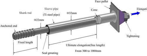
2.1.1. Structure and working principle of the CRLD cable
As a kind of extensible cable with composite structure, the used CRLD cable mainly consists of a rod body, constant-resistance body, constant-resistance sleeve pipe, pallet, and tightening nut (see ). Both constant-resistance body and sleeve pipe constitute the constant resistance device, which can provide constant supporting resistance for the cable (Tao et al. Citation2018c, Citation2019).
Figure 1. Illustration of the structure of CRLD cable.
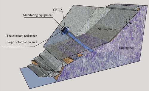
When a landslide occurs, the deformation energy from the rocks is slowly released on the side slope, which then leads to relative motion between the sliding body and the sliding bed. As rock deformation exceeds the designed constant resistance, the constant-resistance body undergoes friction and slippage along the constant-resistance sleeve pipe. As shown in , the CRLD cable can be axially extended with the increasing deformation of the side slope rocks to slowly absorb the produced energy in landslide deformation. Accordingly, failure induced by very large deformation in conventional monitoring can be effectively avoided, i.e. landslide monitoring and warning in advance can be achieved. Furthermore, landslides can be forecasted and judged early according to monitoring curves to take adequate emergency measures and avoid danger.
Figure 2. Reinforcing and monitoring principle of a CRLD cable on side slope.
2.1.2. Working principle of the remote monitoring equipment
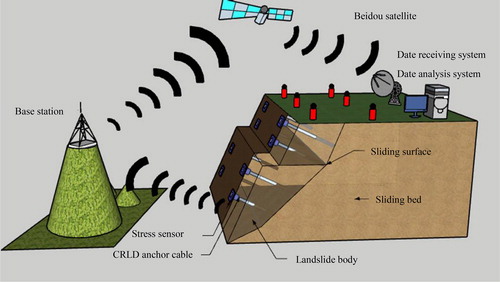
The developed remote monitoring and early warning system includes two parts: indoor equipment and field equipment. The indoor equipment mainly consists of a data receiving/processing/analysis system, 3S maps of the target area around the monitoring point, 3D monitoring engineering image searching system, and some auxiliary analysis software, while the field equipment is mainly composed of the Beidou Satellite receiving device, data processing system and information display system. The signal receiver is used for receiving data and signals from the emitting system and for transmitting the received signals to the computer for analysis and processing. Therefore, the field monitoring points can be unceasingly monitored to acquire continuous monitoring data. illustrates the working principle of the system.
Figure 3. Working principle of the developed remote monitoring and early warning system.
2.1.3. Disadvantages and advantages of the monitoring technology
The cost of this technology is caused by three parts: (1) the total cost of field construction; (2) the cost of both hardware and software of the monitoring equipment; (3) the cost of equipment operation and network. With regard to the large deformation of the slope, other monitoring approaches are likely to fail. Due to the adoption of the CRLD anchor cable in this technology, this monitoring system can still maintain desired operation within a 2 m deformation of the slope. However, this technology also has several limitations, e.g. (1) The technology can ensure that the CRLD anchor cable passes through several potential sliding surfaces and is anchored on a relatively stable slide bed; however, it cannot determine the location and depth of the slipped sliding surface when the landslide occurs. (2) This technology adopts the CRLD anchor cable, which passes through the potential sliding surface (belt) and is anchored on a relatively stable slide bed via drilling, grouting, solidification, tension, and other relevant processes. The construction period is relatively long, and the mechanical equipment is cumbersome, resulting in a minimum installation period for a monitoring point (including construction) of 15 days; thus, it is difficult to achieve emergency monitoring of landslides.
2.2. Development necessity of the disaster monitoring app
The developed remote and intelligent monitoring and early warning system of the stable state of the side slope can indirectly measure the sliding force on the potential sliding surface and achieve effective and reliable monitoring and early warning of a landslide. However, with the advent of the era of the mobile Internet, many details in the system need to be updated first.
(1) Low data view efficiency during the field equipment debugging period
Field debugging data are mainly acquired and viewed by the personnel in a remote monitoring centre via smart phones and examined on the servers, suggesting low data viewing efficiency.
(2) Failure to realize automatic early warning in real time
Since the electronic equipment is always subjected to enormous interference, abnormal jumping points may appear in the monitoring data, thereby resulting in false prediction. To completely eradicate false and mis-predictions, early warning information is mainly sent out through artificial recognition of sudden changes in the monitoring curves. Accordingly, early warnings are generally poor in efficiency and timeliness.
To address the above problems, this study developed a remote landslide monitoring App based on a cloud service platform and existing research results. Unlike other monitoring systems based on Web browsers, data can be directly transmitted to the terminals using the App (such as smart phones and tablet computers), with a delay of less than one second. Due to the development of the App, mobile informationization in the landslide monitoring domain can be promoted. Thus, the users can fully experience the conveniences achieved by mobile Internet and mobile management, thus achieving the goal of pushing information anywhere, at any time, and in real time.
displays the topological structure of the developed disaster monitoring App, which shows that the App mainly includes three layers: the sensing layer, the network layer, and the application layer.
Figure 4. Illustration of topological structure of the developed disaster monitoring App.
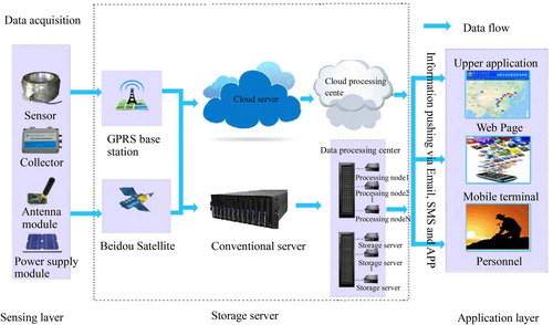
(1) Sensing layer
Using the developed landslide monitoring device, the monitoring data acquired by pressure sensors were then transmitted to the integrated equipment of general packet radio service (GPRS) and Beidou, thus achieving two-channel communication of GPRS and Beidou. The communication mode can be automatically switched when a communication failure occurs to ensure uninterrupted data transmission.
(2) Network layer
A cloud platform transmits the received data to the cloud service and cloud database for acquiring background data of the developed App. The system can manage and analyze the acquired information, generate dynamic curves for conducting early warning analysis, and visually display the early warning results. When the monitoring data exceeds the critical point of early warning, an early warning prompt message can be automatically sent out.
(3) Application layer
The monitoring data of the side slope stable state can be published via Emails, Web pages, and Apps. The relevant personnel can be authorized to log on to the network or acquire the related data using smart phones to quickly and dynamically determine the stable state of landslides, which can further enhance the timeliness of early warning.
3. Design and development of the app system
3.1. System architecture
Following the concept and framework of service-oriented architecture (SOA), the developed remote and intelligent landslide monitoring App as a type of foundation business platform for geological disaster monitoring information management software should satisfy the business requirements of various industries and be able to adapt to varying environments to enhance the platform’s flexibility and adaptability.
The developed disaster App essentially has the following functions: acquisition of landslide monitoring data, pushing of landslide early warning threshold values, generation of stability curves of side slope, addition and revision of monitoring points, and publishing of landslide prediction and forecasting information. Due to the popularization of smart phones and GIS technique, the App uses the Android platform architecture, uses the WebService generated by the servers, and then compares the returned values of WebService. According to the criterion of early warning, red/yellow/blue early warning signals are generated. Moreover, based on the secondary development of Google Map API, the map layer is self-defined, and the acquired disaster monitoring and early warning information is displayed on the map for the convenience of user inquiries. In addition, detailed stability of the side slope can also be displayed via dynamic linking.
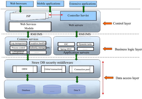
As shown in , in terms of technical framework, the developed App can be divided into three layers: the control layer, the business logic layer, and the data access layer. Based on the SOA principle, the App uses the Spring MVC framework and completely uses J2EE distributed technology and a pure Browser/Server (B/S) architecture.
Figure 5. Basic multi-layer architecture of the developed App.
3.2. System modules and functions
The developed remote and intelligent landslide monitoring App essentially includes the following modules: authority management, data management, rule management, user management, statistical function, interface design, and monitoring point updating. lists the detailed system modules and the related functions.
Table 1. Detailed system modules and functions.
3.3. Design of system database security
(1) Data stabilization. The developed App uses elastic compute service (ECS), with a data reliability of at least 99.99%. In addition, the system can achieve automatic downtime and migration as well as automatic snapshot backup, which is convenient and efficient for data recovery.
(2) Data security. The cloud server has many security measures including Distributed Denial of Service (DDoS) protection, Trojan killing, and anti-brute-force to ensure safety and reliability of disaster monitoring data. When unpredictable failure occurs in the primary library, relation database service (RDS) would be automatically switched to the primary library within an instant, with a data recovery time of less than 5 min. In addition to automatic timing backup, RDS also supports the backup of user-automatic database instance (i.e. data snapshot), so that the database instance can be recovered any time from a data snapshot.
(3) Data privacy. The passwords authorized by the users are transmitted using Message-Digest Algorithm version.5 (MD5) encryption. At the data interface, key information is acquired and revised via secondary validation.
(4) Data validity. Before the submission of information, the users should strictly judge and restrict the formats to avoid the appearance of invalid information in the database and ensure rapid acquisition of monitoring data.
3.4. Early monitoring criterion and functions
In previous reports, He et al. proposed four early warning levels of landslides that are marked by four different colours: red, orange, yellow, and blue. Accordingly, the four-level early warning criterion based on the thresholds (namely, almost-landslide, near-landslide, less-stable, and stable) was developed (He Citation2009; He et al. Citation2010). Automatic early warning functions can be achieved by programming.
3.5. Foreground application system of the developed App
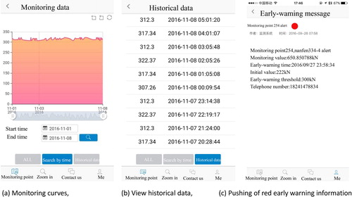
and display the interfaces of the foreground application system of the developed remote and intelligent landslide monitoring App. The App has five interfaces: input of authorized codes, coloured early warnings, monitoring curves, historical curves, and early warning experts.
Figure 6. Designed interfaces of the App.
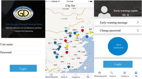
Figure 7. Some functional interfaces of the developed cloud-based landslide monitoring App.
The development of cloud-based landslide monitoring App needs to possess the following functions:
Users can check the stable states of the monitoring points anywhere and at any time to obtain rapid and accurate data reading.
Inspection personnel can manually add and delete monitoring points via smart phones in the field.
Interference data can be effectively filtered out by appropriate algorithms. According to the criteria of early warning, when the data reach the early warning threshold, the information can be pushed in real time and an appropriate response can be timely implemented.
The rule management module allows the setting of threshold monitoring data (i.e. the setting of early warning rules) for the users and it has configuration functions of one-button informing of the contact number. In case of danger, notices can be sent out using ‘one-button notification’, as shown in .
Monitoring curves,
View historical data,
Pushing of red early warning information
3.6. Backstage management system of the developed App
As shown in , the backstage WEB management system of the developed landslide monitoring App includes the following five key management modules.
Figure 8. Backstage WEB management system of the developed multi-source landslide monitoring App.
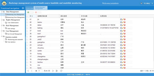
Data management. The App can manage monitoring areas and monitoring points on the platform, including addition, deletion, revision, browsing, and viewing of monitoring area and monitoring points.
Management of monitoring points. The App can view, add, delete, and revise various information of each monitoring area on the platform, including identity (ID), name, province, and position.
Management of authority. Two types of users (ordinary users and administrators) can query and revise action authorization on the backstage management platform.
Rule management. The App can allow users to set the threshold (i.e. setting of early warning rules) and functions of one-button informing of contacts. By editing the configuration values and telephone information, the functions of monitoring thresholds and one-button informing of the contacts can be completed.
Management of users. The App can also add, delete and revise essential information of users and authorities as well as the list of members.
4. Field application and result analysis of the technology
4.1. Engineering background
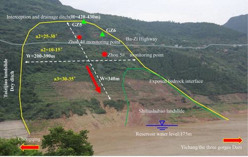
Badong is located to the east of the Daba Mountain and on the slope of the right bank of the Yangtze River. This county backs into the mountain and faces the water, which is 68 km away from Sandouping Town, where the toe of the Three Gorges Dam is located. The Yangtze River flows through the northern county from west to east. The slide mass is mainly colluvial deposits consisting of fragmented stony soil, crushed rocks, and a small amount of cohesive soil. The slide bed is mainly a flexible and loose zone of bedrock, which is composed of marlstone, aubergine mudstone, and siltstone. Due to a series of actions including tectonics, gravity, and weathering, the slide bed is nearly flat or only slightly inclined towards the outside of the mountain, and the rocks are severely crushed and deformed. displays the characteristics of the landslide mass.
Figure 9. Characteristics of landslide mass in Badong Bay along the Three Gorges Dam.
4.2. Design of monitoring points
According to the structural characteristics and scale of old landslide masses along the Badong segment of the Three Gorges Reservoir Region, two sliding-force monitoring points and GPS surface-displacement monitoring points were installed on the landslide mass in May 2016. Specifically, each sliding-force monitoring point included a set of GRPS communication modules and a set of Beidou communication modules. All monitoring points satisfied the sighting condition. As this area covers thicker Quaternary strata and the surface rock mass is severely weathered, the yellow early warning threshold of the sliding force was set to 550 kN (±12 kN) in this area.
The monitoring points have been operating normally since June 2016. In , the deep sliding-force monitoring points are represented by dots while original surface-displacement GPS monitoring points are represented by green triangles.
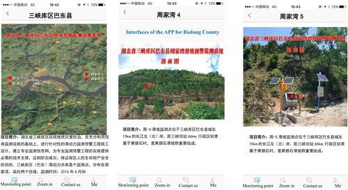
4.3. Design of user interface (UI) of the developed monitoring app
The user interface of the developed remote and intelligent landslide monitoring system for the Badong segment in the Three Gorges Reservoir Region was designed following the idea and framework of service-oriented architecture. displays the final designed user interface of the landslide monitoring App.
Figure 10. Interfaces of the developed landslide monitoring and early warning App for Badong County in the Three Gorges Reservoir.
4.4. Analysis of the monitoring results
On 2 July 2016, the developed landslide monitoring system and App publishing platform successfully warned of a local landslide and fractures forming around monitoring points Zhou 4# and Zhou 5#, six days in advance of the actual landslide occurrence.
During the period from 21 June 2016 to 20 June 2016, widespread rain struck Badong, with a maximum daily rainfall of up to 32.3 mm. Abnormal variations were clearly observed at two sliding-force monitoring points in Zhoujiawan (Zhou 4# and Zhou 5#) and the nearby surface-displacement monitoring points (GZ5 and GZ6). In particular, the deep sliding-force exhibited most significant changes.
At the monitoring point Zhou 4#, the sliding force increased from 382 kN to 539 kN from 0:35 on 6 June 2016 to 4:58 on 2 July 2016, with a sliding force increment of 157 kN.
At the monitoring point Zhou 5#, the sliding force increased from 360 kN to 656 kN from 0:35 on 6 June 2016 to 4:58 on 2 July 2016, with a sliding force increment of 296 kN.
As stated above, fractures appear with an increasing sliding force and a landslide occurs accompanied by the sudden change in sliding force. According to this early warning criterion and the above-mentioned change characteristics, the developed App sounded the yellow alarm at Point A and Point C on 2 July 2016. It was suggested that residents in the danger zone should install the developed landslide monitoring App, strengthen mass prediction and disaster prevention, and improve the precaution awareness of landslides within the area. When the residents found the development of fractures or abnormal sound, they evacuated in an orderly manner along the Ba-Zi Road towards both east and west sides and found nearest refuges, recorded and uploaded the occurrence time and disaster characteristics through the system, and set obvious warning signs on both sides of the road in the predicted danger region.
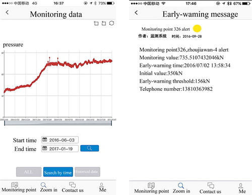
displays the comprehensive data at Zhou 4# monitoring point and the early warning information publishing interface of the developed App.
Figure 11. Monitoring curves at monitoring point Zhou 4# and published of early warning information on the developed App.
displays the variation curves at the sliding-forced monitoring points (Zhou 4# and Zhou 5#) and the nearby surface-displacement monitoring points (GZ5 and GZ6) in the danger zone.
Figure 12. Monitoring curves of sliding force and surface displacement in Zhoujiawan.
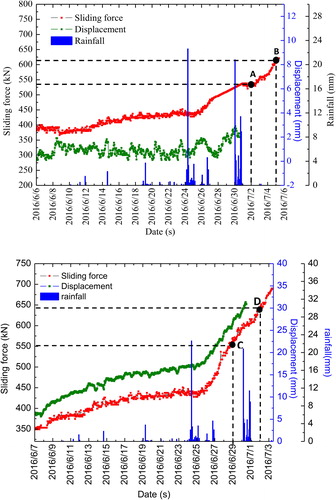
On 2 July 2016 and 29 June 2016, warning information was sent out at the sliding-force monitoring points Zhou 4# and Zhou 5#.
At 8:40, 7 July 2016, residents found and reported local fractures, and farmers around the citrus orchards stopped farming.
Monitoring points Zhou 4# and GZ5 and (b) monitoring points Zhou 5# and GZ6
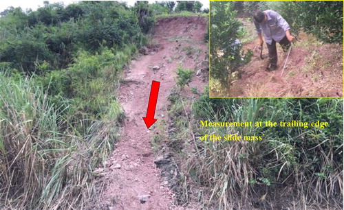
At 14:30, 7 July 2016, investigators performed field measurements using smart phones with the developed App, and found fresh fractures of slab ends at the trailing edge of the slide mass, with a height difference of approximately 12 cm, a length of approximately 8 m, and a fracture width of approximately 5 cm. Due to rain, fragments that were produced during fracturing accumulated on the surface of the slide slope, as shown in .
Figure 13. Deformation characteristics of the slide mass in Zhoujiawan.
5. Conclusions
Through the design of an App-based intelligent landslide monitoring system and its effective application in the Three Gorges Reservoir Region, several conclusions can be obtained:
As a natural mechanical system, landslides depend on a balance between the ‘sliding force’ and the ‘anti-sliding force’. The sliding force can be utilized as a more accurate parameter for landslide forecasting. Remote landslide monitoring systems are developed to directly measure the axial force on the monitoring cables, and the sliding force on the potential sliding surface can be calculated using the axial force. Successful applications in Zhoujiawan landslides demonstrated that the sliding force shows an obvious reaction before the occurrence of a landslide.
The App-based intelligent landslide monitoring system can warn of geological disasters in a timely and dynamic manner, and achieves strong practicability and operability. According to the criterion of automatic early warning, early warning information can be pushed when the monitored sliding force data reaches the early warning threshold. Thus, users can assess the stability of the slope by the App anywhere and at any time and take effective and timely emergency response actions.
The developed disaster forecasting App notified users of a potential risk six days before a landslide occurred at Zhoujiawan in the Three Gorges Reservoir Region. Moreover, the residents in the danger zone dynamically recorded and uploaded field damage characteristics on site, truly achieving the goal of mass measurement and early prevention of geological disasters. In addition, the developed App-based intelligent landslide monitoring system for the Three Gorges Reservoir Region satisfies data transmission and mutual query requirements under complex conditions and exhibits favourable timeliness, intelligence, adaptability, and stability.
Disclosure statement
No potential conflict of interest was reported by the authors.
Additional information
Funding
Related Research Data
References
- Allasia P, Manconi A, Giordan D, Baldo M, Lollino G. 2013. ADVICE: a new approach for near-real-time monitoring of surface displacements in landslide hazard scenarios. Sensors. 13(7):8285–8302.
- Alrawabdeh A, Moussa A, Foroutan M, El-Sheimy N, Habib A. 2017. Time series UAV image-based point clouds for landslide progression evaluation applications. Sensors. 17(10):1–22.
- Chen Y, Irfan M, Uchimura T, Zhang K. 2018. Feasibility of using elastic wave velocity monitoring for early warning of rainfall-induced slope failure. Sensors. 18(4):997.
- Chen Y, Uchimura T, Irfan M, Huang D, Xie J. 2017. Detection of water infiltration and deformation of unsaturated soils by elastic wave velocity. Landslides. 14(3):1–16.
- Geertsema M, Schwab JW, Blais-Stevens A, Sakals ME. 2009. Landslides impacting linear infrastructure in west central British Columbia. Nat Hazards. 48(1):59–72.
- Guzzetti F, Stark CP, Salvati P. 2005. Evaluation of flood and landslide risk to the population of Italy. Environ Manage. 36(1):15–36.
- He M. 2009. Real-time remote monitoring and forecasting system for geological disasters of landslides and its engineering application. Chin J Rock Mech Eng. 28(6):1081–1090. Chinese.
- He M, Gong W, Wang J, Qi P, Tao Z, Du S, Peng Y. 2014. Development of a novel energy-absorbing bolt with extraordinarily large elongation and constant resistance. Int J Rock Mech Min Sci. 67:29–42.
- He M, Li C, Gong W, Sousa LR, Li S. 2017. Dynamic tests for a constant-resistance-large-deformation bolt using a modified SHTB system. Tunn Undergr Space Technol. 64:103–116.
- He M, Wang Y, Tao Z. 2010. A new early-warning prediction system for monitoring shear force of fault plane in the active fault. J Rock Mech Geotech Eng. 2(3):223–231.
- Huang FM, Chen LX, Yin KL, Huang J, Gui L. 2018. Object-oriented change detection and damage assessment using high-resolution remote sensing images, Tangjiao Landslide, Three Gorges Reservoir, China. Environ Earth Sci. 77(5):183.
- Huang F, Huang J, Jiang S, Zhou C. 2017a. Landslide displacement prediction based on multivariable chaotic model and extreme learning machine. Eng Geol. 218:173–186.
- Huang FM, Luo XY, Liu WP. 2017b. Stability analysis of hydrodynamic pressure landslides with different permeability coefficients affected by reservoir water level fluctuations and rainstorms. Water. 9(7):450.
- Huang WP, Li C, Zhang LW, Yuan Q, Zheng YS, Liu Y. 2018. In situ identification of water-permeable fractured zone in overlying composite strata. Int J Rock Mech Min Sci. 105:85–97.
- Li Y, Chen G, Wang B, Zheng L, Zhang Y, Tang C. 2013. A new approach of combining aerial photography with satellite imagery for landslide detection. Nat Hazards. 66(2):649–669.
- Li YY, Huang JS, Jiang SH, Huang F, Chang Z. 2017. A web-based GPS system for displacement monitoring and failure mechanism analysis of reservoir landslide. Sci Rep. 7(1):17171.
- Li Y, Zhang S, Zhang X. 2018. Classification and fractal characteristics of coal rock fragments under uniaxial cyclic loading conditions. Arab J Geosci. 11(9):201.
- Lu XJ, Fan XB, Li LK, Wu P. 2017. Design and implementation of mass monitoring and mass prevention system of geological hazard. Sci Surv Mapp. 42(3):149–154. Chinese.
- Peppa MV, Mills JP, Moore P, Miller PE, Chambers JE. 2017. Brief communication: landslide motion from cross correlation of UAV-derived morphological attributes. Nat Hazards Earth Syst Sci. 17(12):2143–2150.
- Peternal T, Kumelj S, Ostir K, Komac M. 2017. Monitoring the Potoškaplanina landslide (NW Slovenia) using UAV photogrammetry and tachymetric measurements. Landslides. 14(1):395–406.
- She D, Zhu XY, Ding J. 2013. Application of cloud computing in geological disaster early warning system. J Yangtze Univ (Nat Sci Ed). 10(13):69–72. Chinese.
- Sun X, Zhang Y, Wang D, Yang J, Xu HC, He MC. 2017. Mechanical properties and supporting effect of CRLD bolts under static pull test conditions. Int J Miner Metall Mater. 24(1):1–9.
- Tang H, Li C, Hu X, Su A, Wang L, Wu Y, Criss R, Xiong C, Li Y. 2015. Evolution characteristics of the Huangtupo landslide based on in situ tunneling and monitoring. Landslides. 12(3):511–521.
- Tao Z, Li M, Zhu C, He M, Zheng X, Yu S. 2018a. Analysis of the critical safety thickness for pretreatment of mined-out areas underlying the final slopes of open-pit mines and the effects of treatment. Shock Vib. 2018:1–8.
- Tao ZG, Wang Y, Zhu C, Xu H, Li G, He M. 2019. Mechanical evolution of constant resistance and large deformation anchor cables and their application in landslide monitoring. Bull Eng Geol Environ. 2019:1–17.
- Tao Z, Zhu C, Zheng X, He M. 2018b. Slope stability evaluation and monitoring of Tonglushan ancient copper mine relics. Adv Mech Eng. 10(8):1–16.
- Tao Z, Zhu Z, Han W, Zhu C, Liu W, Zheng X, Yin X, He M. 2018c. Static tension test and the finite element analysis of constant resistance and large deformation anchor cable. Adv Mech Eng. 10(12):168781401881063.
- Tsai ZX, You GJY, Lee HY, Chiu YJ. 2012. Use of a total station to monitor post-failure sediment yields in landslide sites of the Shihmen reservoir watershed, Taiwan. Geomorphology. 139:438–451.
- Turner D, Lucieer A, de Jong SM. 2015. Time series analysis of landslide dynamics using an unmanned aerial vehicle (UAV). Remote Sens. 7(2):1736–1757.
- Wang X, Meng F. 2018. Statistical analysis of large accidents in China’s coal mines in 2016. Nat Hazards. 92(1):311–325.
- Zhu C, Tao Z, Yang S, Zhao S. 2018. V shaped gully method for controlling rockfall on high-steep slopes in China. Bull Eng Geol Environ. 2018:1–7.