
Abstract
The analysis of 4 year In-SAR Interferometry images and a detailed geomorphological survey have been carried out to detect a large Deep-Seated Gravitational Slopes (DSGSD) affecting the urban area of the Episcopia village, in Southern Italy. The DSGSD largely develops within phyllites of the Liguride Units and, in the upper slope, within Pleistocene sand and conglomerate deposits of the Sant’Arcangelo Basin. Field survey has shown trenches at the top and an evident bulge at the base of the DSGSD, corresponding to the Talweg of the Sinni River. Geological and geomorphological field surveys allowed us to hypothesize a listric geometry of the DSGSD subsurface plane reaching about 700 m of depth. Furthermore, the multi-temporal In-SAR Interferometry analysis collected from November 2014 to May 2017 revealed that a ground deformation of ±30 mm was occurred, and the process is still active in the whole area.
1. Introduction
A world-wide scientific literature is deals with the Deep-Seated Gravitational Slope Deformations, treating many local case studies characterized by a great variety of geological and geomorphological settings (Agliardi et al. Citation2001; Panek and Limes Citation2016 and references therein; Frattini et al. Citation2018). DSGSD is an acronym of the Deep-Seated Gravitational Slope Deformation referring to gravity-induced slope mass movements that affect high relief mountain slopes over long periods of time and at low rates (Engelen Citation1963; Goguel Citation1978; Dramis Citation1984; Sorriso-Valvo Citation1984; Cavallin et al. Citation1987; Agliardi et al. Citation2001; Pasuto and Soldati Citation2013). It is classified between landslides and a faulting process that affects the slopes and displaces rock mass downward for several kilometres squares and up to 100 m depth, and the detailed processes responsible for their genesis are not well understood yet (Agliardi et al. Citation2001, 2009a, Citation2009b). The typical DSGSD features are double ridges, trenches, tension cracks, uphill facing scarps (counter scarps or antislope scarps), downthrown blocks, buckling folds, toe bulging, and secondary mass movements (Agliardi et al. Citation2001; Panek and Limes Citation2016). The DSGSDs are world-wide recognized (Panek and Limes Citation2016) and are peculiar phenomenon of the Italian Alp and Apennine chains (Cavallin et al. Citation1987; Agliardi et al. Citation2001, 2009a, Citation2009b; Forcella and Orombelli Citation1984; Berardino et al. Citation2003; Guerricchio Citation2005; Di Martire et al. Citation2016; Frattini et al. Citation2018). All over the world there are a lot of experiences of satellite images classification in the field of geology (Pascale et al. Citation2013, Citation2014; Sarma et al. Citation2015; Nath et al. Citation2015; Partheepan et al. Citation2016). The aim of the study is to investigate the Episcopia DSGSD, already recognized by Bentivenga et al. (Citation2009, Citation2017), using a multidisciplinary approach that consists on both the geological and geomorphological field surveys, integrated by aerial photogrammetry and thematic map interpretations, and a multitemporal image analysis by means of the In-SAR Interferometry technique.
This technology has developed in recent years thanks to the availability of images with increasing resolution and short repetition times (Rosen et al. Citation2000; Zebker and Goldstein Citation1986; Dumitru and Datcu Citation2013). The accuracy of these techniques depends on many parameters including the morphological characteristics of the study area (Moran et al. Citation1998), hooting geometry and weather conditions. A threshold of the In-SAR analysis for the detection of DSGDS is due to the presence of externalities that modify results such as strong earthquakes (Massonnet et al. Citation1993), volcanic eruptions, human activities and heavy rainfall events (Faccini et al. Citation2012), among others.
The DSGSDs area that affects the whole Episcopia urban settlement is characterized of many landslides and is bounded by the Monaco and Confine Streams on the left and the right, respectively. Aerial photogrammetry interpretation confirmed by field surveys have revealed the typical morphological features of DSGSD that involves the whole slope until to the Sinni River valley and the urban settlement of Episcopia producing severe damage buildings.
2. Geological and geomorphological settings
The southern Apennines chain (), a Miocene to Pleistocene fold-and-thrust belt, is composed of east-verging tectonic units (Pescatore et al. Citation1999 and references therein) overlapping on the Apulian Platform and is characterized by large duplex geometries (Patacca and Scandone Citation2007 and references therein). The study area is located in the eastern sector of the south-Appennine chain and is formed by the Mesozoic to Cenozoic Apennines Unit successions overlapped by Pliocene to Pleistocene clastic deposits (). The Apennines units are represented by the Liguride Unit (Amodio Morelli et al. Citation1976) composed of different tectonic units named Frido, Crete Nere, Saraceno and Albidona fms (Vezzani Citation1969; Bonardi et al. Citation1988; Monaco et al. Citation1991; Cavalcante et al. Citation2012). The Frido Fm is the highest tectonic unit; it is divided in two tectonic subunits, Cretaceous to Oligocene in age (Monaco and Tortorici Citation1995; Schiattarella Citation1996), and is composed of polydeformed metamorphic rocks with associated blocks of ophiolite-bearing and continental-type rocks ( and ). The ophiolitic rocks are mainly represented by serpentinized peridotite and metabasite (Vezzani Citation1967, Citation1969). The Crete Nere, Saraceno and Albidona fms are the tectonic units underlying the Frido one. The Crete Nere Fm (Knott Citation1987; Bonardi et al. Citation1988) is a deep-sea water succession, Cretaceous to Eocene in age, formed by quartzarenites and arenaceous limestones interbedded to black shales ( and ). It is stratigraphically covered by the Saraceno Fm that is composed of calcareous turbidites mainly formed by thin layers of limestones, marls and clay. Finally, an angular unconformity divides the Saraceno Fm, at bottom, and the Albidona Fm to the top. This latter is formed by turbidite facies that vary from arenaceous to pelite in the bottom to conglomerate-arenaceous toward the top ( and ). This succession represents the infill of the Miocene thrust-top/foredeep basins developed in the frontal sector of the southern Apennines accretionary wedge. Starting from the Eocene the area was affected by four tectonic events that were developed at several crustal levels and with different metamorphic grade (Knott Citation1987; Monaco and Tortorici Citation1995; Schiattarella Citation1996). The lower Miocene tectonic event generated NE-verging fold-and-thrusts involving both the Ophiolite and siliciclastic units. Differently, during the middle Pleistocene it was active a NW-SE oriented normal faulting that partially re-activate the older structures. The Liguride unit successions are lying by the marine to continental clastic deposits of the Sant’Arcangelo basin “Auctt.”, a Pliocene to Pleistocene basin filled by up to 2500 m thick deposits (Vezzani Citation1967; Hippolyte et al. Citation1994; Pieri et al. Citation1994). The sedimentary succession in the study area is formed from bottom to top by Late Pliocene to Early Pleistocene polygenetic conglomerate with yellow sandy matrix that constitutes the Castronuovo Fm. This latter is overlapped by the fluvial conglomerates and sands with red sand matrix of the Middle Pleistocene Serra Corneta Fm (Vezzani Citation1967).
Figure 1. Geological sketch map of southern Italy (Bentivenga et al. Citation2004a, modified).
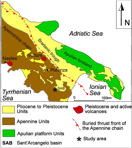
Figure 2. Geological sketch map of the study area. Legend: 1: landslide deposits; 2: alluvial deposits; 3: Serra Corneta Fm (Middle Pleistocene); 4: Castronuovo Fm (Late Pliocene to Early Pleistocene); 5: Saraceno Fm (Late Oligocene to Early Miocene); 6: Crete Nere Fm (Cretaceous to Middle Eocene); 7: Frido Fm (Oligocene); 8: Bed attitude; 9: Tectonic boundary; 10: DSGSD boundary; 11: Trace of geological cross-sections in .
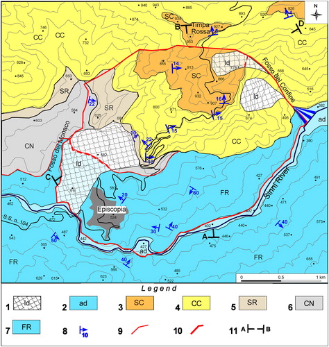
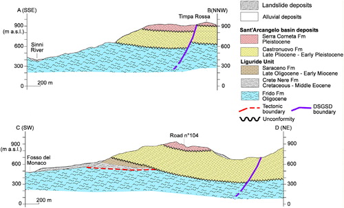
Figure 3. Geological cross-sections of the study area. Geological profile traces are reported on .
The landscape of southern Apennine chain is formed of a shape that change from planar coastal plain areas bounding the Tyrrhenian, Adriatic and Ionian seas to the high-relief peaks of the axial zone of the chain, through a hill-side area differently extended. Considering that, it can be roughly divided into three morphological zones (inner, axial and outer belts) parallel to its NW-SE-elongation axis (). The inner belt corresponds to the Tyrrhenian side of the Sele coastal Plain and the Cilento Promontory, with a maximum elevation reached at Cervati Mt. (1900 m a.s.l.). Transverse incised fluvial valleys drive westward the main rivers toward the Tyrrhenian Sea, locally producing narrow gorges of one hundred metres deep. The axial belt corresponds to the highest mountains peaks that are up to 2000 m a.s.l. and includes the remnants of the Pliocene to Pleistocene erosion land surfaces uplifted and dismembered by Quaternary faults (Schiattarella et al. Citation2013; Giano Citation2016). Block-faulted mountains bounded by high-angle fault scarps retreated by slope replacement processes (Giano and Schiattarella Citation2014; Giano et al. Citation2018) are also present. They are alternated with tectonically controlled basins filled by fluvial to lacustrine deposits (Di Leo et al. Citation2009; Giano Citation2011; Aucelli et al. Citation2014; Giano et al. Citation2014). The fluvial network follows the regional dip of the chain and often transversally cut the bedrock to flow into the Tyrrhenian, Adriatic, or Ionian seas. The outer belt of the chain is characterized by a general passive north-eastward tilting as a consequence of the uplift of the axial zone of the chain (Giano and Giannandrea Citation2014; Bentivenga and Piccarreta Citation2016; Bentivenga et al. Citation2014). This is also supported by the drainage network that often flows perpendicularly to the main tectonic structures, in agreement with the regional slope of the belt (Cinque et al. Citation1993; Bentivenga et al. Citation2004a; Scorpio et al. Citation2015) toward to both the Adriatic and Ionian seas. The outer belt displays a landscape with a lower elevation than the axial belt and does not exceed 1100 m a.s.l.; the fluvial valleys are oriented from NE-SW in the northern sector to E-W in the southern sector and transversally cut the plain bending of the chain.
3. Materials and methods
The use of a multidisciplinary approach is needed for the Episcopia area considering a variety of instability processes that occurs in the whole area. To this aims, topographic contour maps at 1:5.000 scale were used to produce both the detailed geological and geomorphological maps. In addition, aerial photos at 1:33000 scale were analysed to integrate the field survey. The geological field survey of the Episcopia area has revealed large slope deformations not only attributable to landslides, but rather than to a deeper mass movement. Furthermore, a detailed geomorphological survey furnished a wide distribution of the features associated to the mass movements. With the aim to investigate the kinematic of slope mass movements and the morphological evolution of the area, a multitemporal analysis by means of I.G.M.I. aerial photos relative to the 1954/55, 1992/93, and 2003 years has been carried out.
DSGDS phenomena can also be analyzed through technologies based on interferometry based on satellite images using Synthetic Aperture RADAR (SAR) technology (Rosen et al. Citation2000; Small and Schubert Citation2008). The most used methodology is the Din-SAR which calculates the phase difference between two images acquired at different times before and after the event (Lanari et al. Citation2007; Massonnet and Feigl Citation1998; Mora et al. Citation2003). The phase difference calculated between the two acquisitions makes it possible to obtain indications of the change in the earth's surface. The measurement of the phase is affected by high de-correlation attributed to conditions of the surface investigated, to different weather conditions and to a large spatial baseline. DSGDS phenomena, being very slow movements, require very long period of observations, analysis that can be carried out using the permanent scatteres (PS) (Ferretti et al. n.Citationd.) technique that exceeds the limits of D-inSAR. This technique aims to identify stable points called persistent scatters and monitor them in the analyzed time frame.
For this purpose, we used 24 images of single look complex (SLC) downloaded free of charge from the Copernicus site (Copernicus https://scihub.copernicus.eu/dhus/#/home, 2017). We used the TOP-SAR images captured by sentinel satellites 1 A and B that produced 23 interferograms. We chose to use images in ascending mode because the study area is hilly and facing south. On the contrary, the acquisition in descending mode would not have given any contribution to the analysis (De Zan and Monti Guarnieri Citation2006; Gernhardt et al. Citation2009; Goldstein and Werner Citation1998).
The dataset of the Interferometry stack (time of acquisition, sensor, mode and data of the spatial baseline) allowed to select the master image so to minimize the temporal and perpendicular baseline dispersion (). The choice of the best Image as reported in the allowed us a better interpretation of the Interferograms improving their quality. The Interferogram images have been produced as follows: (a) Co-registration of both master and slave pair images, coming from the same sub swath, using the orbit of the two images and a DEM; (b) Creation of the Interferogram (Prati et al. Citation1990; Gabriel et al. Citation1989); (c) Removal of the topographic phase thus to remove the DEM from the Interferogram; (d) Phase of filtering to improve the accuracy of the phase unwrapping (Zebker and Goldstein Citation1986); (e) phase of unwrapping to resolve the correlation between the Interferometric and topographic phases (Small and Schubert Citation2008; Derauw and Orban Citation2004); (f) unwrapped phase in vertical displacement has been transformed (Ferretti et al. Citation2007).
Figure 4. Optimal In-SAR master selection showing the choice of the best image.
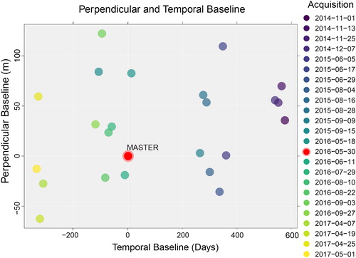
Table 1. Dataset used for the interferometric analysis.
These interferometric pairs are combined to improve the Signal to Noise Ratio SNR (Costantini Citation1998) represented by the ratio of power signal and power noise. Finally, for displacements analysis, we use the Coherent Pixels Technique (CPT) (Mora et al. Citation2003; Blanco-Sànchez et al. Citation2008). This method is based on the coherence estimation, in fact the displacement analysis is realized on high coherent pixels that show a time-stable electromagnetic reaction. The CPT method allows to extract a list of differential interferograms regarding on the deformation affecting wide areas and large time intervals (Di Martire et al. Citation2016; Frattini et al. Citation2018).
4. Results
4.1. Geomorphological analysis
A wide slope of about XX° of slope angle and located in the left side of the upstream Sinni River is the study area. It is bounded by the Sinni River in the downside and by flat top surfaces in the upside. The small village of Episcopia is placed on the left side of the Sinni River, where many landslides of different wideness and width are located (). Different types of landslides such as rotational slides and earth flows cover almost the whole study area thus to mask the main and widest mass movement. The geomorphological analysis of the southern area of the Timpa Rossa site allowed us the recognition of some trenches laterally jointing to stream channels and other trenches placed at the base of the main slopes ( and ). The wider landslides are found on the left side of the Monaco Stream and their main scarps have affected in the movement the Pleistocene conglomerates and sands deposits of the Sant’Arcangelo basin. Smaller secondary scarps also involved deposits of the Liguride units. In the right side of Fosso del Confine Stream, the main landslide scarps involved only conglomerates and sand of both the Serra Corneta and Castronuovo formations. On the slope near to the Episcopia village, some head of landslides show slope deposits arranged on a convex downward slope profile. The wider landslides of the study area have been interpreted as rotational slide because of the occurrence of backward tilting terraces, and also as complex landslides formed by rotational slide in the head and by earth flow in the toe (sensu Varnes Citation1978; Carrara et al. Citation1985; Bentivenga et al. Citation2012). The smaller landslides affecting the urban area of the Episcopia village and surroundings, the south-east sector and the whole base slope of the Sinni River, on its right side. In this latter case, only the deposits of the Liguride Unit are involved in the movement. The landslides of the study area shown in specify the type of movement and the state of activity. This latter parameter came from both the field morphological surveys and the built damages evaluation. The active landslides are mainly located along the valley-side of the Monaco and Confine streams, in the urban area of the Episcopia Village and at the base slope of the right side of the Sinni River ( for details). The fluvial pattern of the Episcopia slope is dendritic in the upper reach and radial in the middle to lower one. In fact, the western streams are tributary of the Monaco Stream, the eastern streams of the Fosso del Confine Stream, and the southern ones of the Sinni River.
Figure 5. Geomorphological map of the Episcopia area.
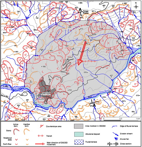
Figure 6. Slope profile showing the sliding plane of the DSGDS and the counter-slope tilting of about 10° that affected the Quaternary clastic successions of both the Castronuovo and Serra Corneta fms.
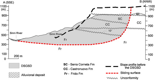
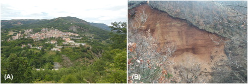
Figure 7. Panoramic view of the DSGDS base-slope, cuts by the Sinni River (A). Detail of the counter-slope tilting of Quaternary deposits (B).
4.2. The deep-seated gravitational slope deformation of the Episcopia village
The detection of the Episcopia DSGSD has been obtained by the joins of geomorphological and geological analyses as well shown in and . In order to analyse the geological area, we measured the extent of the rotation suffered by the DSGSD area based on the physical correlation of a stratigraphic horizons guide represented by the unconformity between the Serra Corneta Fm and the Castronuovo Fm ( and ). This stratigraphic boundary is easily to observe and map because the Serra Corneta deposit is reddish in colour whilst the Castronuovo deposit is yellow. This unconformity is sub-horizontal in the whole surrounding area and conversely downward to the main trench it is rotated counter-slope of about 10°. As a consequence, a gravitational subsidence of the upper side and a backward tilting of the entire slope is shown (). It has been taken into consideration some important morphological clues as the evident trenches upstream of the slope of Episcopia. In this sector, there are two evident trenches characterized by an arcuate trend with the concavity towards the valley. The first and main trench has an E-W trending direction south to the Timpa Rossa site and curves laterally towards the valley thus to produce a connection with the tributary of the left-side valley of the Sinni River. In particular, the trench joins laterally the streams of the western side to those of the eastern one. The second trench, mapped on the southern side (), has a same trend of the previous one and is connected to the west with a left tributary of the Monaco Stream and to the east with the Confine Stream. At the base of the slope flows the Sinni River that is characterized by a curved channel with a convexity toward south, especially in the place at the base of the Episcopia village (Bentivenga et al. Citation2004b; Citation2017). In addition, along the curved fluvial reach there are not formed terraces alluvial. This further morphological evidence allowed us to accurately define the area involved by DSGSD that turns out to be equal of about 6 km2. The upstream bounds of the DSGSD corresponds to the main trench, laterally to both the Matassa and Monaco streams to the east and the Fosso del Confine Stream to the west and to the Sinni River to the south. The size of the deep gravitational movement that involved the slope of Episcopia corresponds to an average width of 2.5 km and an average length of about 2.4 km. The depth of the DSGSD has been derived from geometric reconstructions involving the whole mass movement and corresponds to about 700 m of thickness (). The geometry of the sliding surface, connecting the upstream trench to the most advanced portion of the foot in the valley floor has been hypothesized as a listric surface (Bentivenga et al. Citation2004b). The geological evidence of the deformation is linked to the counter-slope movement of the geological boundary between the Serra Corneta Fm and the underlying Castronuovo Fm. Moreover, the well-preserved morphological evidence such as the upstream trenches, the incision streams, the absence of fluvial terraces along the Sinni River and its right-side lateral planation are field evidence of the activity of the gravitative movement. Further, the distribution of active landslides that are placed along the stream sides and in the urban area of the Episcopia village supports the above-mentioned field evidence ().
4.3. In-SAR interferometry analysis
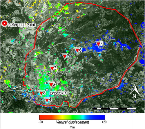
The first step of In-SAR interferometry analysis concerned individually the years 2014, 2015, 2016, and 2017, in a second one all the time span from November 2014 to May 2017 was analyzed, thus to compute the mean ground displacement occurring in the analyzed time span. The choice of the best coherent pixels was obtained applying a mask to the mean coherence thus to exclude all coherent pixel values lower than 0.40 (Mora et al. Citation2003). In fact, coherent pixel values lower than 0.40 indicate ground areas that changes more frequently and correspond mostly to woody and cultivated areas, whilst those with values higher than 0.40 are typical of no-frequently change areas such as a road, rocky areas or roof of buildings. The reference point, considered as a stable ground point with regard to the analyzed time span, is chosen out of the red perimeter that bound the study area () which is considered stable by previous geomorphological studies. Note that the relative value of ground displacement obtained by the fixed external reference point are quite the same if we change the spatial position of the reference point. shows the ground displacement maps from 2014 to 2017 and the location of Control Points (CP) used for monitoring of the Episcopia DSGSD. Displacements of the different spatial values related to each CP are reported in and their trend is illustrated in . A growth of the ground displacement is observed in 2015 that get 26.66 mm in the CP 5 (), located in the upper side of the study area. A trend inversion on the CP points is shown between the 2015 and 2016, changing from a positive to a negative trend that could be interpreted as a horizontal translation of the ground surface. shows a deviation of the pins in 2015 from the average trend. To understand the different trend, the dataset concerning the water cumulations for each month from November 2014 to May 2017 has been analyzed, shown in where for each month the water cumulation in millimetre has been reported. In October 2015, the largest accumulation of rain was recorded with a value of 279.2 mm. The data were acquired by the monitoring unit (lat 40° 4'10.00 "N long 16° 6'23.00 "E) of the Basilicata functional center of the Civil Protection. This peak of rain in the year 2015 helps us to explain the reversal of the trend of displacement in the same period.
Figure 8. Ground surface displacement map from 2014 to 2017 years of observation. Red line shows the boundary of the study area, whereas red point (on the left of each map) indicate the ground CP related to a stable area. Source: Image from Google Earth
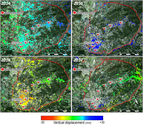
Figure 9. Regression line of the Pin displacement.
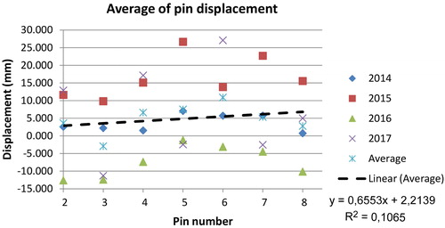
Figure 10. Diagram showing the distribution of the rainfall (mm) at the Episcopia village from November 2014 to May 2017.
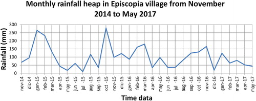
Table 2. Pin displacement (mm) of each CP.
The general trend of the pin displacement shows a positive linear increase (). This means that there has been a slow increase in the ground movement in the last 4 years, corresponding to a range of −30 and +30 mm. If we observe the figure showing the cumulative years of the ground displacement, it is possible to recognize small negative values in both the urban area and the south-western sector of the Episcopia village that in some case are quite close to zero values, corresponding to the absence of ground movement. Conversely, more consistent positive values are found in the central and northern sector of the study area ().
Figure 11. Mean vertical displacement. Source: (Image from Google Earth)
5. Discussion and conclusions
The Episcopia area is located in the axial zone of the southern Apennines and has been affected by a strong regional uplift starting from Middle Pleistocene that was responsible for the high relief of the area (Amato et al. Citation2003; Schiattarella et al. Citation2003, Citation2013; Giano and Giannandrea Citation2014). As a consequence, a deep fluvial vertical incision and large landslides were activated in the whole site, and in the occurrence of the high uplift rate the Episcopia slope was affected by the DSGSD movement. The downward movement of the DSGSD modified the slope producing an upslope trench and, in the downslope, a clear deviation of about 800 m toward the south of the Sinni River channel (). As a result, the Sinni River valley become transversally asymmetric, the right-side valley is steeper than the left one and is affected by many landslides focused in front of the Episcopia village. A clear field evidence of the downward movement of the DSGSD is also the break of the Sinni fluvial terraces arrangement (Bentivenga et al. Citation2004a). Moreover, two streams bound the DSGSD, both left tributaries of the Sinni River, the Fosso del Monaco Stream on the west-side and the Fosso del Confine on the east-side are deeply entrenched. Their valley-sides are affected by many active landslides, such as that in the Fosso del Monaco Stream affecting the north-eastern area of the Episcopia village. An older movement of the DSGSD involved the whole Episcopia slope from NNE to SSW, whereas a younger one partially affecting the slope from NW to SE thus to form the Fosso Lomea trench. These movements are also highlighted by the displacement and the rotation of about 10° toward the SW of the stratigraphic horizon between the Serra Corneta and Castronuovo Fms. Based on these information, we have reconstructed the displacement plane of the DSGSD by means of geological sections that allowed to measure at about 700 m of depth its thickness. The vertical displacement in the upslope area and the horizontal translation on its downside are the morphological features that allowed us to suppose a listric geometry of the subsurface plane (Hutchinson Citation1988). Furthermore, the recent surveying has shown the occurrence of many active landslides with seasonal activity in the south-eastern sector of the DSGSD. They are mainly placed along the valley sides of the Fosso del Monaco and Fosso del confine streams and represent a strong field evidence that led us to consider still active the DSGSD of the Episcopia area (Bentivenga et al. Citation2004b). The interferometric analysis is a preliminary result that shows the consistency with geological field surveys, i.e., the stability of the north area and a movement of the south-west area that includes the urban zone. In the case of the Episcopia DSGSD, it would be wise to expand the observation dataset and use more accuracy methodologies for Persistent Scatters choice and analysis of the low coherence pixel (Press et al. Citation1992). The paper has shown that combining both the field survey and the In-SAR interferometry technique analysis a more detail could be obtained in the study of active processes that affect the landscape such as the DSGSD. Furthermore, these data together with a multitemporal analysis of aerial photo are relevant for the recognition of landscape modification, overall in the last decades.
Disclosure statement
No potential conflict of interest was reported by the authors.
Related Research Data
References
- Agliardi F, Crosta G, Zanchi A. 2001. Structural constraints on deep-seated slope deformation kinematics. Eng Geol. 59(1–2):83–102.
- Agliardi F, Crosta G, Zanchi A, Ravazzi C. 2009. Onset and timing of deep-seated gravitational slope deformations in the Eastern Alps, Italy. Geomorphology. 103(1):113–129.
- Agliardi F, Zanchi A, Crosta G. 2009. Tectonic vs. gravitational morphostructures in the central Eastern Alps (Italy): constraints on the recent evolution of the mountain range. Tectonophysics. 474(1–2):250–270.
- Amato A, Aucelli PPC, Cinque A. 2003. The long-term denudation rate in Southern Apennines Chain (Italy): a GIS-aided estimation of the rock volumes eroded since middle Pleistocene time. Quatern Int. 101–102:3–11.
- Amodio Morelli L, Bonardi G, Colonna V, Dietrich D, Giunta G, Ippolito F, Liguori V, Lorenzoni S, Paglionico A, Perrone V, et al. 1976. L’Arco Calabro-Peloritano nell’Orogene Appenninico-Maghrebide. Mem Soc Geol It. 17:1–60.
- Aucelli PPC, D’Argenio B, Della Seta M, Giano SI, Schiattarella M. 2014. Intermontane basins: quaternary morphoevolution of Central-Southern Italy. Rend Fis Acc Lincei. 25(S2):107–110.
- Bentivenga M, Coltorti M, Prosser G, Tavarnelli E. 2004. A new Interpretation of Terraces in the Taranto Gulf: the role of extensional faulting. Geomorphology. 60(3–4):383–402.
- Bentivenga M, Coltorti M, Prosser G. 2004b. Il movimento gravitativo profondo di Craco (Basilicata Ionica). Il Quaternario Ital J Quat. Sci. 17(2/2):613–625.
- Bentivenga M, Capolongo D, Palladino G, Piccarreta M. 2014. Geomorphological map of the area between Craco and Pisticci (Basilicata, Italy). J Maps. 11(2):267–277.
- Bentivenga M, Laurita S, Palladino G, Prosser G, Saroli M. 2009. Studio geologico e geomorfologico della DGPV di Episcopia (PZ) (Basilicata Centro-Meridionale). Rend Online Soc Geol It. 6:47–48.
- Bentivenga M, Palladino G, Caputi A. 2012. Development of the Pietra Maura landslide and interactions with the Marsico Nuovo dam (Basilicata - Italy). Geografia Fisica e Dinamica Quaternaria.:35.13–22.
- Bentivenga M, Piccarreta M. 2016. Geomorphological map of Pisticci area (Basilicata, Southern Italy). J Maps. 11: 267–277.
- Bentivenga M, Giano SI, Murgante B, Nolè G, Palladino G, Prosser G, Saganeiti L. 2017. Deep-Seated Gravitational Slope Deformation in urban areas matching field and In-SAR interferometry surveys: the case study of the Episcopia village, southern Italy. Lecture Notes in Computer Science, 10407 LNCS, pp. 662–674.
- Berardino P, Costantini M, Franceschetti G, Iodice A, Pietranera L, Rizzo V. 2003. Use of differential SAR interferometry in monitoring and modelling large slope instability at Maratea (Basilicata, Italy). Eng Geol. 68(1–2):31–51.
- Blanco-Sànchez P, Mallorquí JJ, Duque S, Monells D. 2008. The Coherent Pixels Technique (CPT): An Advanced DInSAR Technique for Nonlinear Deformation Monitoring. In Earth Sciences and Mathematics. Basel: Birkhäuser. 1167–1193. doi:10.1007/978-3-7643-8907-9_10.
- Bonardi G, Amore FO, Ciampo G, De Capoa P, Micconet P, Perrone V. 1988. Il complesso Liguride. Auct.: stato delle conoscenze e problemi aperti sulla sua evoluzione pre-appenninica ed i suoi rapporti con l’Arco Calabro. Mem Soc Geol It. 41:17–35.
- Carrara A, D’Elia B, Semenza E. 1985. Classificazione e nomenclatura dei movimenti franosi. Geologia Applicata e Idrogeologia. 20:223–243.
- Cavalcante F, Belviso C, Laurita S, Prosser G. 2012. P-T constraints from phyllosilicates of the Liguride Complex of the Pollino area (Southern Apennines, Italy): Geological inferences. Ofioliti. 37:65–75.
- Cavallin A, Crescenti U, Dramis F, Prestininzi A, Sorriso-Valvo M. 1987. Tipologia e diffusione delle deformazioni gravitative profonde di versante in Italia. Mem Soc Geol It. 37:241–252.
- Cinque A, Patacca E, Scandone P, Tozzi M. 1993. Quaternary kinematic evolution of the Southern Apennines. Relationships between surface geological features and deep lithospheric structures. Ann Geofis. 36:249–260.
- Costantini M. 1998. A novel phase unwrapping method based on network programming. IEEE Trans Geosci Remote Sensing. 36(3):813–821. doi:10.1109/36.673674.
- De Zan F, Monti Guarnieri A. 2006. TOPSAR: Terrain Observation by Progressive Scans. IEEE Trans Geosci Remote Sensing. 44(9):2352–2360. doi:10.1109/TGRS.2006.873853.
- Derauw D, Orban A. 2004. Baseline combination for InSAR dem atimetric resolution enhancement. Proceedings of the FRINGE 2003 Workshop (ESA SP-550).
- Di Leo P, Giano SI, Gioia D, Mattei M, Pescatore E, Schiattarella M. 2009. Evoluzione morfotettonica quaternaria del bacino intermontano di Sanza (Appennino meridionale). Il Quaternario It J Quat Sci. 22:189–206.
- Di Martire D, Novellino A, Ramondini M, Calcaterra D. 2016. A-differential synthetic aperture radar interferometry analysis of a deep seated gravitational slope deformation occurring at Bisaccia (Italy). Sci Total Env. 550:556–573. doi:10.1016/J.SCITOTENV.2016.01.102.
- Dramis F. 1984. Aspetti geomorfologici e fattori genetici delle deformazioni gravitative profonde di versante. Atti I Sem DSGS Boll Soc Geol It. 103:681–687.
- Dumitru CO, Datcu M. 2013. Information Content of Very High Resolution SAR Images: Study of Feature Extraction and Imaging Parameters. IEEE Trans Geosci Remote Sensing. 51(8):4591–4610. doi:10.1109/TGRS.2013.2265413.
- Engelen GB. 1963. Gravity Tectonics in the North-Western Dolomites (N. Italy). Geol Ultraiectina. 13:1–92.
- Faccini F, Robbiano A, Sacchini A. 2012. Geomorphic hazards and intense rainfall: the case study of the Recco Stream catchment (Eastern Liguria, Italy). Nat Hazards Earth Syst Sci. 12(4):893–903. doi:10.5194/nhess-12-893-2012.
- Ferretti A, Monti-Guarnieri A, Prati C, Rocca F. 2007. InSAR Principles: Guidelines for SAR Interferometry Processing and Interpretation. Karen Fletcher, Ed. Retrieved from https://www.esa.int/esapub/tm/tm19/TM-19_ptA.pdf.
- Ferretti A, Prati C, Rocca F. n.d.. Permanent scatterers in SAR interferometry. In IEEE 1999 International Geoscience and Remote Sensing Symposium. IGARSS’99 (Cat. No.99CH36293). 3:1528–1530. doi:10.1109/IGARSS.1999.772008.
- Forcella F, Orombelli G. 1984. Holocene slope deformations in Valfurva, Central Alps, Italy. Geogr Fis Dinam Quat. 7:41–48.
- Frattini P, Crosta GB, Rossini M, Allievi J. 2018. Activity and kinematic behaviour of deep-seated landslides from PS-InSAR displacement rate measurements. Landslides. 15(6):1053–1070. doi:10.1007/s10346-017-0940-6.
- Gabriel AK, Goldstein RM, Zebker HA. 1989. Mapping small elevation changes over large areas: Differential radar interferometry. J Geophys Res. 94(B7):9183. doi:10.1029/JB094iB07p09183.
- Gernhardt S, Adam N, Hinz S, Bamler R 2009. Appearance of persistent scatterers for different TERRASAR-X acquisition modes. In: Proceedings of ISPRS; p. 1-5. ISPRS, Hannover, Germany
- Giano SI. 2011. Quaternary alluvial fan systems of the Agri intermontane basin (southern Italy): Tectonic and climatic controls. Geologica Carpathica. 62(1):65–76. 78/v 10096-011-0006-y
- Giano SI, Giannandrea P. 2014. Late Pleistocene differential uplift inferred from the analysis of fluvial terraces (southern Apennines, Italy). Geomorphology. 217:89–105. doi:10.1016/j.geomorph.2014.04.016.
- Giano SI, Gioia D, Schiattarella M. 2014. Morphotectonic evolution of connected intermontane basins from the southern Apennines, Italy: the legacy of the pre-existing structurally controlled landscape. Rend Fis Acc Lincei. 25(S2):241–252. doi:10.1007/s12210-014-0325-x.
- Giano SI, Pescatore E, Agosta F, Prosser G. 2018. Geomorphic evidence of Quaternary tectonics within an underlap fault zone of southern Apennines, Italy. Geomorphology. 303:172–190. doi:10.1016/j.geomorph.2017.11.020.
- Giano SI, Schiattarella M. 2014. Age constraints and denudation rate of a multistage fault line scarp: an example from Southern Italy. Geochronometria. 41(3):245–255. doi:10.2478/s13386-013-0158-x.
- Giano SI. 2016. Geomorphology of the Agri intermontane basin (Val d’Agri-Lagonegrese National Park, Southern Italy). J Maps. 12(4):639–648. doi:10.1080/17445647.2015.1068715.
- Goguel J. 1978. Scale-dependent rockslide mechanisms, with emphasis on the role of pore fluid vaporisation. In: Voight B. Rockslides and Avalanches. Develop in Geotechnical Engineer. 14a Elsevier Amsterdam.
- Goldstein RM, Werner CL. 1998. Radar interferogram phase filtering for Geophysical applications. Geophys Res Lett. 25(21):4035–4038.
- Guerricchio A. 2005. Tectonics, deep seated gravitational slope deformations (DSGSDs) and large landslides in the calabrian region (Southern Italy). Giornale di Geologia Applicata. 1:73–90.
- Hippolyte JC, Angelier J, Roure F, Casero P. 1994. Piggyback basin development and thrust belt evolution: structural and palaeostress analyses of Plio-Quaternary basins in the Southern Apennines. J Struct Geol. 16(2):159–173.
- Hutchinson JN. 1988. General report: morphological and geotechnical parameters of landslide in relation to geology and hydrogeology. In: Proceedings of 5th ISL Landslides. 1.
- Lanari R, Casu F, Manzo M, Zeni G, Berardino P, Manunta M, Pepe A. 2007. An Overview of the Small BAseline Subset Algorithm: A DInSAR Technique for Surface Deformation Analysis. Deformation and Gravity Change: Indicators of Isostasy, Tectonics, Volcanism, and Climate Change. Basel: Birkhäuser. 637–661. doi:10.1007/978-3-7643-8417-3_2.
- Knott SD. 1987. The Liguride complex of Southern Italy a Cretaceous to Paleogene accretionary wedge. Tectonophysics. 142(2-4):217–226.
- Massonnet D, Rossi M, Carmona C, Adragna F, Peltzer G, Feigl K, Rabaute T. 1993. The displacement field of the Landers earthquake mapped by radar interferometry. Nature. 364(6433):138–142. doi:10.1038/364138a0.
- Massonnet D, Feigl KL. 1998. Radar interferometry and its application to changes in the Earth’s surface. Rev Geophys. 36(4):441–500. doi:10.1029/97RG03139.
- Mora O, Mallorqui JJ, Broquetas A. 2003. Linear and nonlinear terrain deformation maps from a reduced set of interferometric SAR images. IEEE Trans Geosci Remote Sensing. 41(10):2243–2253. doi:10.1109/TGRS.2003.814657.
- Moran MS, Vidal A, Troufleau D, Inoue Y, Mitchell TA. 1998. Ku- and C-band SAR for discriminating agricultural crop and soil conditions. IEEE Trans Geosci Remote Sensing. 36(1):265–272. doi:10.1109/36.655335.
- Mallorquí JJ, Mora O, Blanco P, Broquetas A. 2003. Linear and non-linear long-term terrain deformation with DInSAR (cpt: coherent pixels technique). In: Proceedings of the FRINGE 2003 Workshop (ESA SP-550).
- Monaco C, Tansi C, Tortorici L, De Francesco AM, Morten L. 1991. Analisi geologico-strutturale dell’Unità del Frido nel confine calabro-lucano (Appennino meridionale). Mem. Soc. Geol. It. 47:341–353.
- Monaco C, Tortorici L. 1995. Tectonic role of ophiolite-bearing terranes in the development of the Southern Apennines orogenic belt. Terra Nova. 7(2):153–160.
- Nath B, Acharjee S, Kumar Mitra A, Majumder D, Murgante B. 2015. A geospatial approach to determine lake depth and configuration of Reingkhyongkine (Pukur Para) Lake, Rangamati Hill District, Bangladesh with multi-temporal satellite data. J. Environ. Acc. Manage. 3(3):243–258.
- Panek T, Limes J. 2016. Temporal behaviour of deep-seated gravitational slope deformations: A review. Earth Sci. Rev. 156:14–38.
- Partheepan K, Acharjee S, Thayanath S, Murgante B. 2016. A remote sensing and geo-informatics approach in watershed planning of irrigation tanks connected with Batticaloa Lagoon: A case study of Unnichchai Watershed. In: Boştenaru Dan, M., Crăciun, C. (eds.) Space and time visualisation, 195–206. Cham: Springer.
- Pascale S, Bellanova J, Losasso L, Perrone A, Giocoli A, Piscitelli S, Murgante B, Sdao F. 2014. Geomorphological Fragility and Mass Movements of the Archaeological Area of “Torre di Satriano” (Basilicata, Southern Italy). In: Murgante B, Misra S, Rocha Ana Maria AC, Torre C, Rocha JG, Falcão MI, Taniar D, Apduhan Bernady O, Gervasi O. (eds.) ICCSA 2014. LNCS, s. Cham: Springer; p. 495–510.
- Pascale S, Parisi S, Mancini A, Schiattarella M, Conforti M, Sole A, Murgante B, Sdao F. 2013. Landslide susceptibility mapping using artificial neural network in the urban area of Senise and San Costantino Albanese (Basilicata, Southern Italy). In: Murgante B, Misra S, Carlini M, Torre Carmelo M, Nguyen HQ, Taniar D, Apduhan Bernady O, Gervasi O. (eds.) ICCSA 2013. LNCS, 7974. Heidelberg: Springer; p. 473–488.
- Pasuto A, Soldati M. 2013. Lateral spreading edited by: Shroder JF, Marston RA, Stoffel M. Treatise on Geomorphology Mountain and Hillslope Geomorphology, San Diego: Academic Press. 7:239–248.
- Patacca E, Scandone P. 2007. Geology of the Southern Apennines. Boll. Soc. Geol. It. (Ital. J. Geosci.). 7:75–119. Special Issue.
- Pescatore T, Renda P, Schiattarella M, Tramutoli M. 1999. Stratigraphic and structural relationship between Meso-Cenozoic Lagonegro basin and coeval carbonate platforms in southern Appennines, Italy. Tectonophysics. 315(1-4):269–286.
- Pieri P, Sabato L, Loiacono F, Marino M. 1994. Il bacino di piggyback di Sant’Arcangelo: evoluzione tettonico-sedimentaria. Boll. Soc. Geol. It. 113:465–481.
- Prati C, Rocca F, Guarnieri AM, Damonti E. 1990. Seismic migration for SAR focusing: Interferometrical applications. IEEE Trans Geosci Remote Sensing. 28(4):627–640.
- Press WH, Teukolsky SA, Vetterling WT, Flannery BP. 1992. Numerical Recipes in C: The Art of Scientific Computing, 2nd ed. Cambridge: Cambridge University Press.
- Rosen PA, Hensley S, Joughin IR, Li FK, Madsen SN, Rodriguez E, Goldstein RM. 2000. Synthetic aperture radar interferometry. Proc IEEE. 88(3):333–382. doi:10.1109/5.838084.
- Sarma JN, Acharjee S, Murgante B. 2015. Morphotectonic study of the Brahmaputra basin using geoinformatics. J Geol Soc India. 86(3):324–330. Springer.
- Schiattarella M, Di Leo P, Beneduce P, Giano SI. 2003. Quaternary uplift vs tectonic loading: a case-study from the Lucanian Apennine, southern Italy. Quatern Int. 101–102:239–251.
- Schiattarella M, Giano SI, Gioia D, Martino C, Nico G. 2013. Age and statistical properties of the summit palaeosurface of southern Italy. Geografia Fisica Dinamica Quaternaria. 36:289–302.
- Schiattarella M. 1996. Tettonica della Catena del Pollino (Confine Calabro-Lucano). Mem Soc Geol It. 51:543–566.
- Scorpio V, Aucelli PPC, Giano SI, Pisano L, Robustelli G, Rosskopf CM, Schiattarella M. 2015. River channel adjustments in Southern Italy over the past 150 years and implications for channel recovery. Geomorphology. 251:77–90. doi:10.1016/j.geomorph.2015.07.008.
- Small D, Schubert A 2008. Guide to ASAR Geocoding. ESA-ESRIN Technical Note RSL-ASAR-GC-AD, Issue: 1.01; University of Zurich: Zurich, Switzerland; p. 1–36.
- Sorriso-Valvo M. 1984. Presentazione, Atti I Sem. DSGS. Boll. Soc. Geol. It. 103:667–669.
- Varnes DJ. 1978. Slope movement types and processes. In: Schuster RL, Krizek RJ, editors. Landslides, analysis and control, transportation research board, special report. Washington, DC: National Academy of Sciences; 176; 11–33.
- Vezzani L. 1967. Il bacino plio-pleistocenico di S. Arcangelo (Lucania). Atti Acc. Gioenia Sc. Suppl. Sc. Geol. s. VI. 18:207–227.
- Vezzani L. 1969. La Formazione del Frido (Neocomiano-Aptiano) tra il Pollino ed il Sinni (Lucania). Geol. Rom. VIII:129–176.
- Zebker HA, Goldstein RM. 1986. Topographic mapping from interferometric synthetic aperture radar observations. J Geophys Res. 91(B5):4993. doi:10.1029/JB091iB05p04993.