
Abstract
The Brindisi di Montagna Scalo Landslide in Southern Italy is an active complex mass movement, which affects the left slope of the Basento River. In the last few decades, this landslide has been continuously monitored, as it directly threatened some of the most important communication routes in the Basilicata Region. Nevertheless, little progresses have been made to prevent further landslide advancement, and continuous maintenance is required. With the aims of better understanding, the main factors controlling the evolution of this landslide, and suggesting the most appropriate countermeasures, a multidisciplinary study, based on the integration of direct and indirect techniques, was carried out. Direct techniques included multi-temporal geomorphological analysis of the slope, alongside geological and structural field observations. Indirect techniques consisted of electrical resistivity tomography acquisition. The combined analyses of the geological and geophysical data showed that Quaternary tectonic processes played a fundamental role as a predisposing factor, whereas seasonal rainfall, and the perpetual undercutting by erosional processes caused by the Basento River at the toe of the landslide are the main triggering mechanisms. The Brindisi di Montagna Scalo Landslide represents an outstanding case-study, concerning the interaction between a flow-like complex landslide and essential linear infrastructure, such as motorways and railways.
1. Introduction
Complex landslides in predominantly clay-bearing sediments are a type of mass movement that is widespread in Southern Italy (i.e. Cotecchia et al. Citation2012; Guerriero et al. Citation2013; Giordan et al. Citation2013; Cotecchia et al. Citation2015). Complex landslides generally consist of a single, or multiple, rotational slides, which evolve downhill to become slow, flow-type mass movements, moving at rates averaging a few metres per months (Parise et al. Citation2012). Complex landslide activity is mainly due to a combination of predisposing factors and determining conditions. The occurrence of flow-prone rocks, such as clays, is considered a fundamental geological condition for a complex landslide slide to occur (Varnes Citation1978). Geological, geomorphological and structural characteristics of a slope are also considered to be primary predisposing factors controlling complex landslide development (Fookes and Wilson Citation1966; Guzzetti et al. Citation1996; Martino et al. Citation2004). Extreme rainfall events, seismicity and human activity, such as excavations, are enumerated among the most important determining conditions (Cotecchia and Del Prete Citation1984; D'Elia et al. Citation1985; Piccarreta et al. Citation2004; Brunetti et al. Citation2013). Because of its geological structure, the Basilicata Region exhibits a high density of complex landslides that cause considerable damage to infrastructure and agricultural lands, concomitant with a huge negative economic impact (Lapenna et al. Citation2005; Bentivenga et al. Citation2012; Perrone et al. Citation2014). In this region, mostly affected is linear infrastructure, such as motorways and railways, which can be intercepted by the path of the landslide. Many residences are also involved. A remarkable example of a complex landslide, developed among the Apennines, in Basilicata, is represented by the large mass movement affecting the left side of the Basento River, between the top of Tempa Pizzuta Hill and the Basento River bottom, in the municipality of Brindisi di Montagna Scalo (Cotecchia et al. Citation1986; Picarelli et al. Citation2005; Bentivenga et al. Citation2006) (). The Brindisi di Montagna Scalo Landslide (hereafter, BMSL) is a c.750 m long, periodically active earthflow, which displays well distinguishable depletion, transfer and accumulation zones (). This landslide is part of a wider sector of the slope, characterized by strong instability, mainly triggered by undercutting at the base of the valley, as a result of erosion by the Basento River (). The mass movement directly affects, or threatens, vital local and inter-regional road and railway infrastructures, as well as highway SS n. 407, the SP n. 37 road, and the Potenza-Metaponto National Railway, therefore, every initiative aimed at reducing the landslide risk is a key priority for cost reduction.
Figure 1. Geological map and cross-section of the BMSL area. The study landslide represented by the grey area. The mapped tectonic structures have been positioned based on both outcrop observations and geophysical data. Electrical Resistivity Tomography profiles are included. Source: Author
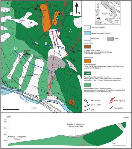
Figure 2. a) Frontal view from the south of the left slope of the Basento River which includes the BMSL; b) interpretation. The main infrastructures involved in the mass movement are included. Source: Author
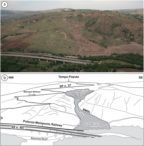
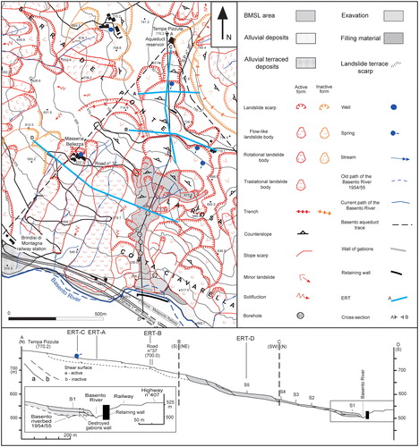
Figure 3. Geomorphological map and cross-section of the study area. The grey colour indicates the area where the BMSL resides. Source: Author
In this paper, an integrated multidisciplinary study, based on the application of complementary investigation methods, including multi-temporal analysis, interpretation of aerial photos, geomorphological and geological field surveys and Electrical Resistivity Tomography (ERT), has been adopted for the study of the BMSL. Both long- and short-term multi-temporal analyses, and interpretation of aerial images, have been performed, with the aim of studying the progressive evolution of the landslide over the years. ERT was also carried out, aimed at better understanding the subsurface structure of the BMSL. The combination of these different disciplines allowed us to identify the critical factors determining the BMSL activity and enabled us to suggest some fundamental initiatives to undertake, in order to avoid further dangerous incursions of the landslide.
2. Methods
An integrated, multidisciplinary approach, including long- and short-term multi-temporal analysis of aerial photos and ERT, supported by numerous field surveys, was adopted for the study of the BMSL. The long-term multi-temporal analysis encompasses the period between 1954 and 2010. Stereoscopic aerial photographs, at a scale of 1:33,000 (1954, 1990), and a detailed field survey (2010) were used to obtain multi-temporal maps. Short-term multi-temporal analysis includes the period between 2013 and 2016; the obtained maps resulted from analysis of satellite images provided by Google Earth. Terminology, such as tension cracks, thrusts and strike-slip faults, has been borrowed from structural geology because of the similarities between characteristics associated with the landslide and tectonic features (Fleming and Johnson Citation1989; Baum and Fleming Citation1996).
With the aim of investigating the deep structure of the BMSL (depth of the sliding surface, deep tectonic structures influencing landslide evolution, etc.), ERT survey was carried out. In recent years, this technique has been increasingly applied in seismotectonic and geomorphological studies (Giocoli et al. Citation2008; Balasco et al. Citation2011), to investigate the geological and structural setting (Giocoli et al. Citation2015) and to study landslides (Perrone et al. Citation2014), ERT is a fast, non-invasive and low-cost geophysical method, widely applied to obtain high-resolution 2-D images of the subsurface resistivity pattern (Mucciarelli et al. Citation2011; Moscatelli et al. Citation2014; Stabile et al. Citation2014). The ERT surveys were performed along four profiles by means of a Syscal R2 (Iris Instruments) resistivity metre, coupled with a multielectrode acquisition system (36, 44 or 48 electrodes). A constant spacing, ‘a’, (10 or 20 m) was used between adjacent electrodes. Along each profile, we applied different array configurations (Wenner, Wenner-Schlumberger and Dipole-Dipole), different combinations of dipole length (1a, 2a and 3a), and ‘n’ number of depth levels (n ≤ 6), obtaining investigation depths of about 70–90 m (for a = 10 m), and 110 m (for a = 20 m). Apparent resistivity data were inverted, using the RES2DINV software (Loke Citation2001), to obtain 2-D resistivity images of the subsurface. For each ERT, we present the 2-D resistivity model obtained from Wenner-Schlumberger configuration that allowed acquiring data with a higher signal-to-noise (s/n) ratio, a larger investigation depth, and a better sensitivity pattern to both horizontal and vertical changes in the subsurface resistivity. In all cases, the root mean squared error was less than 8.7%, and the estimated resistivity values range from 2 to more than 60 Ωm.
Finally, several field surveys allowed the main features recognized by the analysis of aerial photographs and the ERT to be linked. The resulting geological and geomorphological maps ( and ) were obtained from a combination of all the different techniques used.
3. Geological setting
The BMSL is located in the Lucanian sector of the Southern Apennines, a NW-SE-oriented fold and thrust-belt, resulting from the deformation of the northern portion of the African Plate, that mainly accreted between the Early Miocene and Middle Pleistocene (Malinverno and Ryan Citation1986; Doglioni Citation1991; Gueguen et al. Citation1998; Patacca and Scandone Citation2007). In particular, the study area is situated along the left side of the Basento River (), where the watercourse is encased by a Mesozoic to Cenozoic succession, consisting of deep-water, argillaceous to arenaceous deposits. Here, the outcropping units have been ascribed to two different Mesozoic-Cenozoic sequences, referred to the Sannio (Lagonegro Basin) and Irpinian units (Selli Citation1962; Pescatore et al. Citation1988; Patacca et al. Citation1992; Patacca and Scandone Citation2007; Cavalcante et al. Citation2011).
In the study area, the Sannio Unit stratigraphy (Patacca et al. Citation1992; Gallicchio et al. Citation1996; Sabato et al. Citation2007; Cavalcante et al. Citation2003; Citation2011) consists of: (i) Argilliti e radiolariti di Campomaggiore – varicoloured (hemi)pelagic clays, with intervening, redeposited calcilutites and silicified biocalcarenites (Aptian to upper Maastrichtian), cropping out between Masseria Bellezza and Costa Ciavarella (). The succession includes a characteristic black shale interval that has been attributed to the global Aptian anoxic event; (ii) Flysch Rosso (Auct.) – alternating hemipelagic to pelagic limestones, with coarse-grained calciclastic horizons and red clays (upper Maastrichtian to upper Eocene) abundantly recognized between La Rosa and Serra Pizzuta (). The Flysch Rosso includes several metres-thick, lens-shaped Maastrichtian breccia bodies, which are considered to be useful key beds for stratigraphic correlation; (iii) clayey–marly interval – alternating varicoloured (hemi)pelagic clays, marls and limestones (upper Eocene to Aquitanian) that crop out poorly in the Tempa Pizzuta area (); (iv) pre-numidian interval – pelagic limestones, coarse-grained calciclastic beds, clays, and marls rich in sponge spicules (Aquitanian–Burdigalian), cropping out at the top of Tempa Pizzuta (). The Flysch Rosso and the clayey–marly interval are not differentiated in , as they are very difficult to distinguish in the field.
The Irpinian Basin deposits (Cocco et al. Citation1974) have locally been recognized as scattered outcrops, unconformably lying above the Sannio Unit. They consist of siliciclastic turbidites, sharply alternating with grey clays, referable to the Gorgoglione Formation (Selli Citation1962) (Serravallian-Tortonian).
The study area is the result of both contractional and transcurrent tectonic phases that have been operational from Early Miocene to Middle Pleistocene (Monaco et al. Citation1998). The outcrops indicate an extended, NE-dipping, steeply-inclined monocline (see geological cross-section in ), whilst detailed field observations have revealed a more complex structural arrangement of the area, based on the recognition of mesoscale NW-SE-trending folds. This trend is consistent with the main shortening direction documented at regional scale in this sector of the Southern Apennine thrust-belt (Piedilato and Prosser Citation2005). Field observations reveal that the mapped monocline is part of a larger fold, which has partially been dismantled by later tectonics and gravitational processes. The observed folds are therefore considered the result of flexural-slip mechanisms that have certainly been favoured by the abundant occurrence of shale and clay interbeds. Contractional structures are systematically cut by a younger generation of Quaternary NNW-SSE-, N-S- and NE-SW-trending strike-slip faults (). In this paper, we demonstrate that these latter structures played a fundamental role in the development of the BMSL.
4. Geomorphological setting
The BMSL is located in the central part of the Basilicata Region, a few kilometres east of Potenza, which coincides with the high-middle sector of the Basento River. The BMSL is part of a 3 km2 wide area, extending from Tempa Pizzuta to the Basento River, largely affected by slope instability (). It is possible to subdivide this area into two distinct sectors. The first sector, encompassing the top of Tempa Pizzuta Hill (770 m above sea-level – asl) to the SP n. 37 (at a height of 675 m asl) ( and ), is characterized by gently-dipping slopes, competent lithologies pertaining to the Flysch Rosso, the clayey–marly interval and the Pre-numidian interval and dormant landslide activity. The second sector, included between the SP n. 37 and the Basento River bottom (500 m asl), is characterized by high acclivities, clayey lithologies, belonging to the Flysch Rosso, Argilliti e radiolariti di Campomaggiore and the Gorgoglione Formation, and intense landslide activity. The BMSL is the most significant feature observable in the second sector. The entire area shows an average slope acclivity of about 10°. It is located between the mountain and hill altitude zones and, similar to great parts of the Southern Apennine area, the observed morphology is the result of two main concomitant factors that have controlled landscape modelling: (i) Pliocene to Quaternary regional uplift, and the consequent increase in fluvial incision; (ii) lithology, and the structural arrangement of the outcropping formations. General features of the area include the occurrence of ephemeral streams, encased in narrow and deep incisions, and abrupt acclivity change that commonly corresponds to tectonic structures and lithological variations (for example, at the boundary of the Argilliti e radiolariti di Campomaggiore and Flysch Rosso). At the base of the slope, the Basento River has a roughly rectilinear path, which is only deflected where it meets the toe of the BMSL. Tributary streams also display a parallel and rectilinear path, sometimes originating from springs that are subject to strong seasonal variations. In the study area, springs have commonly been observed to appear at the boundary between the Argilliti e radiolariti di Campomaggiore and the overlying Flysch Rosso, or in the more fractured portion of the Flysch Rosso succession. The main geomorphologic instabilities are observed in the argillaceous parts of the Sannio Unit. In the geomorphological map in , different landslide types, affecting the investigated slope, have been reported, according to Varnes (Citation1978). Earthflows are the most commonly recognized landslide type. Complex, rotational and translational slides are also common.
5. The Brindisi di Montagna Landslide
The BMSL is a multi-source landslide, consisting of a strongly active rotational to translational upper portion that evolves downslope into an earthflow (Carrara et al. Citation1985; Cotecchia et al. Citation1986; Picarelli et al. Citation2005; Bentivenga et al. Citation2006; Bentivenga et al. Citation2012; De Luca et al. Citation2015; Spilotro et al. Citation2015; Varnes Citation1978) (). Currently, the BMSL has a total length L = 7.6 × 10² m. It is located in the lower sector of the study area and, in plain view, it displays a wide depletion area with an average width W = 1.4 × 10² m, an elongated channel, and a lobe-shaped toe (). The L/W ratio is 5.4. The landslide head scarp is located at an elevation of 695 m, and the landslide toe at 520 m, giving a total relief H = 175 m. The H/L ratio is 0.2. Cotecchia et al. (Citation1986) documented a yearly average velocity of 0.6–3.6 m/yr; however, the landslide has demonstrated quite high velocities during the main stages of re-activation, with peaks of 60 cm/day, followed by a slow decrease with time (Cruden and Varnes Citation1986). The landslide developed entirely in the structurally complex successions of the Argilliti e radiolariti di Campomaggiore and the Flysch Rosso Formations. The landslide material consists of fissured clays and shales, alternating in different proportions with fractured calcareous and cherty beds. In particular, the landslide starts in the Flysch Rosso lithologies, showing structures of type B1, as defined by Esu (Citation1977), with repeated coherent layers made up of limestones and cherts. The channel and toe zones entirely developed within the Argilliti e radiolariti di Campomaggiore formation, comprising prevailingly clayey deposits and isolated coherent lithologies. Structures of types B2 and B3, as defined by Esu (Citation1977), are fully representative of these deposits.
Figure 4. a) Panorama view of the BMSL taken from La Rosa. From this position all the main landslide elements forming the study landslide as well as the depletion, transfer and accumulation zones are visible; b) view of the BMSL crown zone from SW. Note the occurrence of different landslide scarps; c) particular of the BMSL channel zone showing well-defined lateral strike-slip fault ridges and water ponds located within ephemeral topographic depressions; d) view of the BMSL toe zone from NE. Note the reduced section of the Basento River and the occurrence of fresh lateral strike-slip fault ridges bounding the active toe. Source: Author
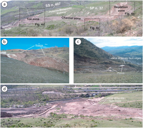
The depletion zone of the BMSL ( and ), where the rotational to translational mechanisms mainly occur, developed between two stable areas, represented by the Serra del Ponte and La Rosa localities. This area mainly consists of three strongly deformed source zones, respectively named the western, central and eastern sources, characterized by active erosion, a large occurrence of trenches, open fractures, water-filled depressions and upslope-tilted blocks. Here, the measured terrain gradient averages 23°. Along the steeply-dipping crown, the main mass movement is often accomplished by falling and toppling mechanisms. In this part of the landslide, a retrogressive evolution has been identified.
The transport zone of the BMSL consists of an elongated channel through which the material, produced in the depletion area, is transferred downward to the deposition zone (). The channel is confined between marked incisions, the activity of which is testified by the presence of well-preserved striated shear planes. Along this tract, the landslide is characterized by an evident hummocky morphology, produced by extensional cracks and contractional corrugation. In this portion, the terrain, the gradient may reach 11°.
The deposition zone of the BMSL (), corresponding to the Basento River valley bottom, consists of a fan-shaped toe that deflects, and periodically interrupts, the watercourse. Here, diffuse cracking and soil corrugation are the most easily recognized features. In this sector, the terrain gradient averages 7°.
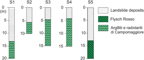
Data concerning the depth of the sliding surface of the BMSL are provided from borehole logs (Cotecchia et al. Citation1986) (). The thickness of the displaced material ranges from about 5 m in the channel zone to 13–14 m measured in the upper part of the channel, and in the toe zone ().
Figure 5. Borehole stratigraphic logs made along the BMSL channel zone (modified by Cotecchia et al.Citation1986).
Currently, the BMSL is threatening, or causing damage to, different infrastructures. In particular, in the uppermost part of the landslide, the SP n. 37 needs constant maintenance because of the severe damage suffered during the last decade. At the landslide’s toe, highway SS n. 407 Basentana, and the Potenza-Metaponto National Railway line, need to be constantly protected from the continuous deposition of landslide material. To prevent a worsening of the situation, a series of reinforced concrete and gabion walls have been realized; however, despite these countermeasures, the incessant downslope displacement of material has led to local restraint of the Basento River, and the consequent development of ephemeral lakes that, added to the lack of an efficient water regime, represent an additional instability factor for the BMSL.
6. Multi-temporal analyses
The BMSL has been periodically active since at least 1954, and its activity has increased dramatically during the last decade, involving the entire slope between Tempa Pizzuta and the Basento River valley bottom (). Earthflow has periodically affected residential structures and farmland, and threatened highway SS n. 407, the SP n. 37 road, and the Potenza-Metaponto National Railway. Multi-temporal landslide maps for the BMSL earthflow were prepared for the long-term (decadal) interval of 1954–2010, and for the short-term period (annual) of 2013–2016 ( and ). For the long-term multi-temporal analysis, we used 1:33,000 stereoscopic aerial photographs, taken in 1954, 1990 and data from a field survey performed on 2010. Long-term analysis provided fundamental indications about the general evolution of the landslide. For the short-term analysis, we used aerial images provided by Google Earth. Short-term analysis allowed the observation of features occurring at the landslide surface that are generally short-lived (seasonal) and can be quickly destroyed by ongoing deformation. The obtained maps ( and ) show the main geomorphological characteristics, and the spatial and temporal evolution, of the landslide.
Figure 6. Long-term multi-temporal landslide maps for the BMSL. Note the progressive increase of the area involved in the landslide movement through the years a) 1954, b) 1990 and c) 2010. Note also the change in Basento River course due to growing of the BMSL toe. Source: Author
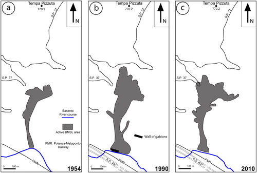
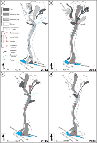
Figure 7. Short-term multi-temporal landslide maps for the BMSL. In all maps, landslide activities and the main landslide features for the years a) 2013, b) 2014, c) 2015, d) 2016 are showed. The landslide activity was detected by direct observation in the field. Source: Author
6.1. Long-term multi-temporal analysis
The first stereoscopic aerial photographs available for the study area date back to 1954 (). In these photographs, the BMSL was about 640 m long, and ranged in elevation from about 675 to 516 m. When compared to the present-day landslide geometry, the BMSL shows a narrower depletion zone and a smaller accumulation zone. The depletion zone consisted of two main source areas, feeding the main earthflow body. Steep morphologies and back-tilted surfaces were common in this part of the landslide. Extensional cracks characterized the transition between the depletion zone and the channel. The channel was also narrower, with an evident neck at about 650 m. Corrugations, related to contractional deformation, have been previously documented (Del Prete Citation1992). At the toe, the Basento River formed a wide curve, which shows no evidence of any involvement in the mass movement. Infrastructure located in the proximity of the landslide (in 1954, the Potenza-Metaponto National Railway was the only existing infrastructure) was also unaffected.
Aerial photographs for the year 1990 () show that significant geomorphological change occurred over the course of 36 years. The active zone of the whole landslide noticeably lengthened, and the depletion and accumulation zones cumulatively enlarged. At this time, the BMSL was about 800 m long, and ranged in elevation from about 690 to 520 m. Significant retrogressive processes markedly had changed the position and geometry of the landslide head scarp, and the western, central and eastern sources had developed. Ponds, ephemeral springs and deeply-incised gullies are visible, especially around the boundary between the Argilliti e radiolariti di Campomaggiore and Flysch Rosso, along the eastern side of the landslide. In the channel zone area, secondary earthflows had joined the main body on both sides; however, the most striking feature is represented by a wide fan-shaped toe, which had invaded the valley bottom, and deflected the course of the Basento River. The necking of the river section gave rise to a landslide lake upstream (Cotecchia et al. Citation1986). Gabions, aimed at protecting the adjacent Potenza-Metaponto National Railway, are clearly visible in the aerial photographs ( and ).
In 2010 (), the geometry of the BMSL had further changed. The BMSL was about 850 m long, and ranged in elevation from about 695 to 520 m. The depletion zone was significantly enlarged. Obvious activity seems to have been on the eastern side, where new rotational slides and secondary earthflows had joined the main body. On the western side, retrogressive evolution of the head scarp had caused the involvement of the SP n. 37 road. The transfer zone geometry also appears to have been more complicated, due to the addition of numerous lateral slides. In addition, the width of the transfer zone appears significantly narrower, compared to the 1990 situation. The accumulation zones appear considerably reduced, probably because of reduced landslide activity and earth removal works.
6.2. Short-term multi-temporal analysis
A view of the short-term evolution of the BMSL was obtained through serial visual analysis of Google Earth imagery, from 2013 to 2016 (). During this period, the earthflow showed repeated geomorphological change, most occurring in the catchment area and at the active toe. Along the transfer zone, the landslide showed different generations of flank ridges and lateral trenches, with the narrowest corresponding to the current active sector of mass movement.
6.2.1. 2013
The BMSL Google Earth image from 2013 goes back to September 25th (). At that time, land removal works were underway in different sectors of the landslide, and numerous dirt roads, allowing access to the most deformed areas, crossed the mass movement at different topographic highs. Landslide activity was mostly concentrated in the source area, where, however, it was represented by a few scattered, shallow earthflows, converging on the transfer channel. In the middle sector, the landslide was characterized by low activity. Here, predominantly erosional processes took place, as testified to by numerous longitudinal deeply-incised streams, which, in many cases, formed at the junctions of the flank ridges. Gullies largely overprinted previous morphologies consisting of tension cracks and thrusts. In the accumulation zone, activity was generally low. The Basento River was narrowed in some parts, and a neck formed in the proximity of the Potenza-Metaponto National Railway led to the formation of a lake upstream. A retaining wall, built at the toe, appears partially disrupted and buried under landslide deposits. Active tension cracks, visible on the eastern side of the toe, in the proximity of the Basento River, were the result of continuous erosive action of the river course.
6.2.2. 2014
The BMSL Google Earth image from 2014 was taken on October 10th (). Different from the previous year, the earthflow indicates a high level of activity. In the catchment area, dirt roads observable in the previous year’s image had been almost completely removed by landslide activity. The main body was mainly fed by the central and eastern sources. Other isolated lateral sources also contributed. Landslide activity in the catchment area was mainly inferred from the occurrence of visible extensional cracks and the freshness of the sliding surfaces. The transfer zone was very active in 2014. High activity is illustrated by the large frequency of fresh extensional cracks, alternating with local contractional zones. Ponds and ephemeral streams are also visible, especially in the upper portion of the channel; however, the most striking evidence is represented by rejuvenated lateral strike-slip faults and, at the boundary with the toe zone, by en echelon fractures. In the accumulation zone, the most active structures are represented by extensional cracks, while thrusts, inherited from previous stages, do not show activity. The opening direction of the extensional cracks is consistent with undercutting erosional processes caused by the Basento River.
6.2.3. 2015
The BMSL Google Earth image from 2015 was taken on May 30th (). Although the landslide was highly active, as in the previous year, significant changes are visible, both in the source and accumulation zone. In the feeding area, the major activity is visible in the correspondence of the western source. Here, new material was added to the landslide, due to the retrogressive evolution of the crowns. Unlike the previous year, the central and eastern sources were active only in providing a minor contribution, in terms of remobilized material. In the transfer zone, the landslide is still confined between marked lateral faults, and corrugation and extensional cracks occur extensively. Lateral lobes, formed from overflow material, are common. In the lower portion, the earthflow is characterized by a significant widening of the toe, which resulted in further necking of the Basento River. Similar to the transfer zone, corrugation and extensional cracks occur abundantly, although are less marked. The narrowing of the river resulted in the widening of the lake, located upstream, and in a threat to the walls in defence of the railway.
6.2.4. 2016
The BMSL Google Earth image from 2016 was taken on July 2th (). Landslide activity at this time was very low. In the depletion area, the three main source areas were, in great part, covered by vegetation. In particular, the central and eastern sectors seem to be almost in a dormant stage, whereas in the western portion, a little activity is observable in the crown area. The entire area is crossed by deeply-incised gullies, which often sit on previous structures, such as lateral faults. Similar characteristics are largely observable in the transfer zone. In fact, longitudinally-oriented deeply-incised gullies are the predominant feature of this zone. In the accumulation zone, the dimensions of the toe are considerably reduced, as a consequence of the Basento River undercutting erosional processes, which are not compensated by the arrival of new material from the depletion and transfer zones.
7. Tectonic structures in the Brindisi di Montagna Scalo landslide area
Slope failure frequently coincides with pre-existing tectonic discontinuities. The fundamental role played by faulting in landslide development in Italy has been highlighted by numerous authors (e.g. Dramis Citation1984; Dramis and Sorriso-Valvo Citation1994; Forcella and Tibaldi Citation1998). In effect, tectonic discontinuities heavily contribute to the weakening of the substrate through the fracturing of rocks, and reduction of shear strength. Fault damage zones represent preferential ways for groundwater flow and migration. Fault distribution can also control the distribution of the surficial hydrographic network.
The eventuality that the BMSL coincides with a zone of tectonic deformation was first proposed by Cotecchia et al (Citation1986), although little field evidence was provided. If demonstrated, the occurrence of tectonic structures controlling the development of the BMSL could explain many characteristics observed in the field and add a fundamental element to take into consideration in the assessment of future risk mitigation. In order to verify this hypothesis, different field surveys have been carried out in recent years; however, diffuse vegetation cover and poorly-preserved outcrops prevented us from getting a clear identification of the tectonic zone. In the case of the BMSL ( and ), field observations are largely prevented due to the occurrence of thick landslide debris. Locally, fresh shear surfaces (striated faults in most cases) have turned out to be related to landslide movements, rather than tectonics. More evidence was discovered from detailed mapping of the Tempa Pizzuta area; here, an NNE-trending dextral transpressional fault was mapped. The mapped structure consists of at least four main splays (f1, f2, f3 and f4 in ), which have a positive flower geometry in the investigated area. All the splays converge southward into the BMSL area, where they can no longer be followed.
With the aim of detecting the possible propagation of the recognized fault zone into the BMSL area, as well as the need to better understand the main characteristics of the mass movement in the subsurface (landslide geometry, sliding surface depth, areas with high water content), a geophysical survey, leading to the acquisition of four ERT (), was carried out (). ERT A, B and D were designed to intersect the mass movement and adjacent areas in a direction nearly orthogonal to the landslide axis in the catchment area. ERT C, an axis-parallel profile, was designed to intersect the crown zone. Considering the data gathered through geological surveying, aerial photo interpretation, and exploratory boreholes (), it was possible to calibrate the resistivity models and directly correlate resistivity values with lithostratigraphic characteristics. The higher resistivity values (>7 Ωm) are associated with the Flysch Rosso, and the lower resistivity values (<7 Ωm) are related to the Argilliti e radiolariti di Campomaggiore. The body of the BMSL is highlighted by low resistivity values (<9 Ωm) at shallow depth.
Figure 8. ERT carried out parallel and transversally to the landslide body axis and interpreted sections obtained by combining ERT and field geological and geomorphological information. See for the location of the ERT profiles. Source: Author
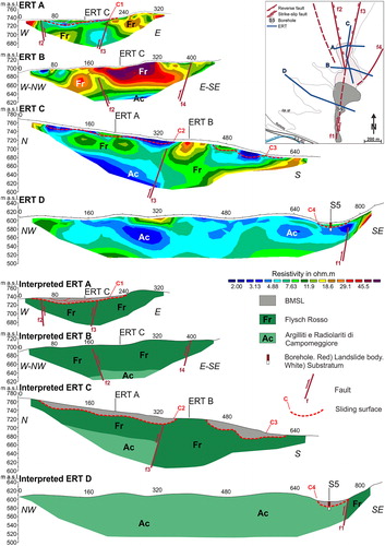
ERT A, B and C ( and ) form a grid, meant to investigate the subsurface characters of the area located between Tempa Pizzuta and the BMSL crown zone, where all the splays, converging towards the BMSL, would be expected. This area is prevalently characterized by dormant rotational slides, which are hardly recognizable in the field or on aerial photographs. The ERT A () shows a concave resistivity contrast (C1), between the topographic surface and about 725 m asl, which is interpreted as the contact between the slide material and the Flysch Rosso. The major features of the ERT A are the two sharp lateral variation of electrical resistivity at about 50 and 200 m, which are interpreted as the f2 and f3 splay, respectively. ERT B () was carried out along one of the crowns of the dormant landslide. It shows a quite firm substrate in the Flysch Rosso, with little evidence of landslide material in the first few metres. The Flysch Rosso/Argilliti e radiolariti di Campomaggiore transition is visible at a depth of about 650 m asl. Abrupt lateral variation of electrical resistivity at about 170 and 400 m are interpreted as the f2 and f4 splay. ERT C () extends longitudinally between the Tempa Pizzuta hilltop and the boundary between the dormant and active areas of the BMSL, intersecting ERT A and B. The main characteristic recognizable in the ERT C is the structural high in the Flysch Rosso, separating the two different sectors. It coincides with a high electrical resistivity zone (>12 Ωm) where thick calciclastic limestones occur within the Flysch Rosso succession, between 360 and 440 m asl. Uphill, in the dormant sector, a shallow electrical resistivity contrast (C2) clearly marks the landslide/Flysch Rosso contact, whereas a deeper electrical resistivity contrast indicates the stratigraphic contact between the Argilliti e radiolariti di Campomaggiore and the overlying Flysch Rosso. Downhill, in the active landslide zone, the ERT shows clear concave sliding surfaces (C3) cutting into the substrate, represented by the Flysch Rosso. The transition between the dormant and active areas of the BMSL is characterized by a sharp lateral variation of electrical resistivity, interpreted as the f3 splay. In this case, the Flysch Rosso/Argilliti e radiolariti di Campomaggiore boundary is used to interpret the f3 splay as a right-lateral strike-slip fault with reverse vertical component. ERT D consists of a long profile carried out immediately south of Masseria Bellezza (). The profile intercepts the BMSL at the transition between the depletion and channel zones. The sliding surface is clearly evidenced by a marked resistivity contrast (C4). The occurrence of a borehole (S5) helped us to better constrain this surface. The sharp lateral variation of electrical resistivity, located on the southeastern side of the landslide, is interpreted as the f1 splay.
8. Results
The multi-temporal analysis of aerial photographs and ERT, presented in the previous sections, has provided the identification of two critical factors controlling the development of the BMSL. Below, we discuss the main results coming from the application of these two techniques to the study of the BMSL.
8.1. Multi-temporal analysis
Both long- and short-term multi-temporal analyses of 1:33,000 stereoscopic aerial photographs and Google Earth images indicate that the BMSL has been periodically active since at least 1954. During the last decade, its activity dramatically increased, leading to restriction of the outflow of the Basento River, and the creation of a lake in the proximity of the landslide’s toe. Continuous reactivations have periodically threatened farmland, residential structures, and important infrastructure, such as highway SS n. 407, the SP n. 37 road and the Potenza-Metaponto National Railway. In 1954, the landslide showed a reduced catchment area and a poorly-developed toe. In more recent times, it has developed a wider, and more complex, depletion zone, because of its retrogressive evolution, and a wide fan-shaped toe, which has diverted the course of the Basento River. In total, from 1954 to now, the landslide has lengthened by 210 m. Aerial photograph analysis of the last few years, and periodic field surveys, have revealed that the landslide is very sensitive to seasonal rainfall recharge, and that it has been frequently reactivated, with the main activity stages occurring during heavy and persistent rainfall events. This is particularly evident from the short-term multi-temporal analysis. In fact, images taken during rainy seasons (October 2014, May 2015) show typical landslide activity features, such as fresh extensional cracks, thrusts and lateral strike-slip faults, with scattered ponds occupying the topographic depressions. Images taken during dry seasons (September 2015, July 2016) show a well-developed network of deeply-incised ephemeral streams, which overprint previous features. This kind of seasonal evolution indicates that the landslide material is not able to release water in the short-term, therefore resulting in persistent water-saturated conditions. The main reactivations are especially involved in the middle to lower part of the landslide, where clayey lithologies, belonging to the Argilliti e radiolariti di Campomaggiore, crop out.
8.2. ERT investigations
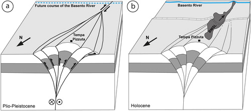
ERT investigations, together with field geological surveys, performed in the BMSL area have revealed that the landslide is associated with a strongly-deformed fault zone. This zone consists of an NNE-trending dextral transpressional fault with at least four main splays (f1, f2, f3 and f4 in ) which display a major reverse component (). A minor dextral strike-slip component, locally deduced by the offset of key stratigraphic horizons, helped us to interpret these structures as transpressional faults. The fault zone is the southward propagation of the fault system recognized in the Tempa Pizzuta area (). Based on these observations, we have interpreted the entire area as a partially-eroded positive flower structure, or a transpressive pop-up, dissecting the previously-formed Apennine contractional structures (). Although a precise age constraint for this tectonic event is not possible based on field data, it is, however, reasonable to refer the observed deformation to Plio-Pleistocene tectonic activity. In fact, in the Southern Apennine thrust-belt, strike-slip tectonics represents the latest evolutionary stages of a chain which overprinted older Cenozoic structures (Catalano et al. Citation1993; Van Dijk et al. Citation2000). The Tempa Pizzuta hilltop represents the culmination of this structural high, and the BMSL developed in association with its southern termination, where the master fault, which follows the BMSL channel/toe segment, splits into several branching splay faults (). Uplift and faulting, related to growth of the recognized structural high, significantly predisposed the study area to landslide collapse. Faulting mainly caused weakening of the substrate and a general reduction in the shear strength. Uplift mainly contributed to gravitational disequilibrium, destabilizing the slope.
Figure 9. Schematic 3D block diagrams showing: (a) the development of a dextral transpressional fault zone in the considered sector of the southern Apennine thrust-belt during Plio-Pleistocene; (b) Present-day position of the BMSL. Not to scale. Source: Author
9. Summary and conclusions
The BMSL is a rotational slide evolving downhill into an earthflow (). It mainly developed in a structurally-complex succession of alternating clay and turbiditic limestones ascribed to the Argilliti e radiolariti di Campomaggiore and Flysch Rosso formations. The depletion area mainly resides in the Flysch Rosso, where turbiditic limestones are predominant. The transfer and accumulation zones occur in the Argilliti e radiolariti di Campomaggiore, which is a predominantly clay-rich unit. Multi-temporal analysis of aerial photos and ERT investigations revealed that two main critical factors controlled, and still strongly influence, the evolution of the Brindisi di Montagna Scalo Landslide: (i) the BMSL is particularly susceptible to seasonal rainfall, which is considered the main triggering factor; (ii) the BMSL mainly formed in association with an intensely-deformed Quaternary fault zone. The recognized faults greatly contributed to the weakening of the substrate, presenting a preferential route for groundwater infiltration and migration. We consider these to be a fundamental predisposing factor.
Based on the recognition of these critical factors, it follows that every measure aimed at stabilizing the landslide and mitigating risk should, in the first instance, consider the removal of water from the landslide body, which would reduce the solid friction and promote longer landslide runouts. Therefore, the realization of an efficient drainage system, that would intercept both surface water and groundwater, could be a valid and relatively cheap solution to minimize movement of the BMSL.
Acknowledgements
The authors wish to thank the editor and two anonymous reviewers for their critical review of the paper.
Disclosure statement
No potential conflict of interest was reported by the authors.
References
- Baum RL, Fleming RW. 1996. Kinematic studies of the Slumgullion landslide, Hinsdale County, Colorado. In: Varnes DJ, Savage WZ, editors. The Slumgullion earth flow: A Large-Scale Natural Laboratory. U.S. Geological Survey Bulletin. 2130; p. 9–12.
- Balasco M, Galli P, Giocoli A, Gueguen E, Lapenna V, Perrone A, Piscitelli S, Rizzo E, Romano G, Siniscalchi A, Votta M. 2011. Deep geophysical electromagnetic section across the middle Aterno Valley (Central Italy): preliminary results after the April 6, 2009 L’Aquila earthquake. Bollettino di Geofisica Teorica ed Applicata. 52(3):443–455.
- Bentivenga M, Grimaldi S, Palladino G. 2006. Caratteri geomorfologici della instabilità del versante sinistro del fiume Basento interessato dalla grande frana di Brindisi di Montagna Scalo (Potenza, Basilicata). Giornale di Geologia Applicata. 4:123–130.
- Bentivenga M, Palladino G, Caputi A. 2012. Development of the Pietra Maura landslide and interactions with the Marsico Nuovo dam (Basilicata - Italy). Geogr. Fis. Din. Quat. 35:13–22.
- Brunetti MT, Luino F, Vennari C, Peruccacci S, Biddoccu M, Valigi D, Luciani S, Cirio CG, Rossi M, Nigrelli G, et al. 2013. Rainfall thresholds for possible occurrence of shallow landslides and debris flows in Italy. In: Stoffel M, Bollschweiler M, Luckman BH, editors. Dating methods of alluvial processes on fans and cones. Adv. Glob. Change Res., 47; p. 327–339.
- Carrara A, D’Elia B, Semenza E. 1985. Classificazione e nomenclatura dei fenomeni franosi. Geologia Applicata e Idrologia. 20:223–243.
- Catalano S, Monaco C, Tortorici L, Tansi C. 1993. Pleistocene strike-slip tectonics in the Lucanian Apennine (Southern Italy). Tectonics. 12(3):656–665.
- Cavalcante F, Fiore S, Piccarreta G, Tateo F. 2003. Geochemical and mineralogical approaches to assessing provenance and deposition of shales: a case study. Clay Miner. 38(3):383–397.
- Cavalcante F, Belviso C, Bentivenga M, Fiore S, Prosser G. 2011. Occurence of palygorskite and sepiolite in upper Paleocene – middle Eocene marine deep sediments of the Lagonegro basin (Southern Apennines – Italy): paleoenvironmental and provenance inferences. Sediment. Geol. 233(1–4):42–52.
- Cocco E, Cravero E, Ortolani F, Pescatore T, Russo M, Sgrosso I, Torre M. 1974. Le unità irpine nell’area a nord di Monte Marzano; Appennino Meridionale. Mem Soc Geol Ital. 18:607–654.
- Cotecchia V, Del Prete M. 1984. The reactivation of large flows in the parts of southern Italy affected by the earthquake of November 1980, with reference to the evolutive mechanism. Proceedings of the international symposium on landslides, Toronto, Canada, 2:33–38.
- Cotecchia V, Del Prete M, Federico A, Fenelli GB, Pellegrino A, Picarelli L. 1986. Studio di una colata in formazioni strutturalmente complesse presso Brindisi di Montagna Scalo (PZ). Atti del XVI Conv. Naz. Geotecnica (A.G.I.), 14-16 maggio, Bologna, 253–264.
- Cotecchia F, Santaloia F, Vitone C, Palladino G. 2012. A slow and complex landslide process in the Southern Apennines (Italy). In: Eberhardt E, Froese C, Turner AK, Lerouil S, editors. Landslides and Engineered Slopes. Protecting Society through Improved Understanding. Proceedings 11th International Symposium Landslides, Banff (Canada), 3–8 June 2012. 1; 1009–1016.
- Cotecchia F, Vitone C, Santaloia F, Pedone G, Bottiglieri O. 2015. Slope instability processes in intensely fissured clays: case histories in the Southern Apennines. Landslides. 12(5):877–893.
- Cruden DM, Varnes DJ. 1986. Landslide types and processes. In: Turner AR and Schuster RL, editors. Landslides: Investigation and mitigation. Sp. Rep. 247, Transportation Research Board, National Research Council, National Academy Press, Washington DC, 36–72.
- D'Elia B, Esu F, Pellegrino A, Pescatore TS. 1985. Some effects on natural slope stability induced by the 1980 Italian earthquake. Proceedings of the 11th International Conference on Soil Mechanics and Foundation Engineering, San Francisco, 1943–1949.
- De Luca V, Bentivenga M, Palladino G, Grimaldi S, Prosser G. 2015. A finite element analysis of the Brindisi di Montagna Scalo earthflow (Basilicata, southern-Italy). In: Lollino G, Giordan D, Crosta GB, Corominas J, Azzam R, Wasowski J, Sciarra N, editors. Engineering geology for society and territory, 2.
- Del Prete M. 1992. Frane per colamento e loro effetti nelle aree dell’Appennino centro-meridionale. In: Vallario A, editor. Frane e territorio. Naples, Italy: Liguori Editore.
- Doglioni C. 1991. A proposal for the kinematic modelling of W-dipping subductions: possible applications to the Tyrrhenian–Apennines system. Terra Nova. 3(4):423–434.
- Dramis F. 1984. Aspetti geomorfologici e fattori genetici delle deformazioni gravitative profonde. Boll Soc Geol Ital. 103:681–687.
- Dramis F, Sorriso-Valvo M. 1994. Deep-seated gravitational slope deformations, related landslides, and tectonics. In: Oyagy N, Sorriso-Valvo M, Voight B, editors. Deep-seated landslides and large-scale rock avalanches. Eng. Geol. 38(3–4):231–243.
- Esu F. 1977. Behaviour of slopes in structurally complex formations. In: Proceedings of International Symposium on the Geotechnics of Structurally Complex Formations. Capri, Italy, 2; p. 292–304.
- Fleming RW, Johnson AM. 1989. Structures associated with strike-slip faults that bound landslide elements. Eng Geol. 27(1–4):39–114.
- Fookes PG, Wilson DD. 1966. The geometry of discontinuities and slope failures in Siwalik Clay. Geotechnique. 16(4):305–320.
- Forcella F, Tibaldi A. 1998. Geomorphological expression of Alpine faults, Orobic Alps, Italy: Late Quaternary reactivation or glacial modelling? Boll Soc Geol Ital. 117:643–655.
- Gallicchio S, Marcucci M, Pieri P, Premoli Silva I, Sabato L, Salvini G. 1996. Stratigraphical data from a Cretaceus claystones sequence of the “Argille Varicolori” in the Southern Apennines (Basilicata, Italy). Palaleopelagos. 6:261–272.
- Giocoli A, Magrì C, Vannoli P, Piscitelli S, Rizzo E, Siniscalchi A, Burrato P, Basso C, Di Nocera S. 2008. Electrical resistivity tomography investigations in the Ufita Valley (Southern Italy). Ann Geophys. 51(1):213–223.
- Giocoli A, Stabile TA, Adurno I, Perrone A, Gallipoli MR, Gueguen E, Norelli E, Piscitelli S. 2015. Geological and geophysical characterization of the southeastern side of the High Agri Valley (Southern Apennines, Italy). Nat Hazards Earth Syst Sci. 15(2):315–323.
- Giordan D, Allasia P, Manconi A, Baldo M, Santangelo M, Cardinali M, Corazza A, Albanese V, Lollino G, Guzzetti F. 2013. Morphological and kinematic evolution of a large earthflow: The Montaguto landslide, Southern Italy. Geomorphology. 187:61–79.
- Gueguen E, Doglioni C, Fernandez M. 1998. On the post-25 Ma geodynamic evolution of the Western Mediterranean. Tectonophysics. 298(1–3):259–269.
- Guerriero L, Revellino P, Coe JA, Focareta M, Grelle G, Albanese V, Corazza A, Guadagno FM. 2013. Multi-temporal Maps of the Montaguto Earth Flow in Southern Italy from 1954 to 2010. J Maps. 9(1):135–145.
- Guzzetti F, Cardinali M, Reichenbach P. 1996. The influence of structural setting and lithology on landslide type and pattern. Environ Eng Geosci. 2:531–555.
- Lapenna V, Lorenzo P, Perrone A, Piscitelli S, Rizzo E, Sdao F. 2005. 2D electrical resistivity imaging of some complex landslides in Lucanian Apennine chain, Southern Italy. Geophysics. 70(3):B11–B18.
- Loke MH. 2001. Tutorial: 2-D and 3-D electrical imaging surveys. http://www.geoelectrical.com
- Malinverno A, Ryan WBF. 1986. Extension in the Tyrrhenian Sea and shortening in the Apennines as a result of arc migration driven by sinking of the lithosphere. Tectonics. 5(2):227–245.
- Martino S, Moscatelli M, Scarascia Mugnozza G. 2004. Quaternary mass movements controlled by a structurally complex setting in the Central Apennines (Italy). Eng Geol. 72(1–2):33–55.
- Monaco C, Tortorici L, Paltrinieri W. 1998. Structural evolution of the Lucanian Apennines, southern Italy. J Struct Geol. 20(5):617–638.
- Moscatelli M, Piscitelli S, Piro S, Stigliano F, Giocoli A, Zamuner D, Marconi F. 2014. Integrated geological and geophysical investigations to characterize the anthropic layer of the Palatine hill and Roman Forum (Rome, Italy). Bull Earthquake Eng. 12(3):1319–1338.
- Mucciarelli M, Bianca M, Ditommaso R, Vona M, Gallipoli MR, Giocoli A, Piscitelli S, Rizzo E, Picozzi M. 2011. Peculiar earthquake damage on a reinforced concrete building in San Gregorio (L’Aquila, Italy): site effects or building defects? Bull Earthquake Eng. 9(3):825–840. doi: 10.1007/s10518-011-9257-3
- Parise M, Federico A, Palladino G. 2012. Historical evolution of multi-source mudslides. In: Eberhardt E, Froese C, Turner AK, Lerouil S, editors. Landslides and Engineered Slopes. Protecting Society through Improved Understanding. Proceedings 11th International Symposium Landslides, Banff (Canada), 3–8 June 2012. 1; p. 401–407.
- Patacca E, Scandone P, Bellatalla M, Perilli N, Santini U. 1992. The Numidian-sand event in the Southern Apennines. Memorie di Scienze Geologiche. 43:297–337.
- Patacca E, Scandone P. 2007. Geology of the Southern Apennines. Boll Soc Geol Ital. 7:75–119.
- Perrone A, Lapenna V, Piscitelli S. 2014. Electrical resistivity tomography technique for landslide investigation: a review. Earth Sci. 135:65–82.
- Pescatore T, Renda P, Tramutoli M. 1988. Rapporti tra le Unità Lagonegresi e le Unità Sicilidi nella media valle del Basento, Lucania (Appennino Meridionale). Mem Soc Geol It. 41:353–361.
- Picarelli L, Urciuoli G, Ramondini M, Comegna L. 2005. Main features of mudslides in tectonised highly fissured clay shales. Landslides. 2(1):15–30.
- Piccarreta M, Capolongo D, Boenzi F. 2004. Trend analysis of precipitation and drought in Basilicata from 1923 to 2000 within a Southern Italy context. Int J Climatol. 24(7):907–922.
- Piedilato S, Prosser G. 2005. Thrust sequences and evolution of the external sector of a fold and thrust belt: An example from the Southern Apennines (Italy). J Geodyn. 39(4):386–402.
- Sabato L, Gallicchio S, Pieri P, Salvini G, Scotti P. 2007. Cretaceous onoxic events in the argilliti e radiolariti di Campomaggiore unit (Lagonegro–Molise Basin, southern Italy). In: Mazzotti A, Patacca E, Scandone P, editors. Results of the CROP project Sub-Project CROP-04 southern Apennines (Italy). Bollettino Società Geologica Italiana, Special Issue, 7; p. 57–74.
- Selli R. 1962. Il paleocene nel quadro della geologia dell'Italia meridionale. Memorie Società Geologica Italiana. 3:129–143.
- Spilotro G, Canora F, Pellicani R, Vitelli F. 2015. Risk and mitigation of the large landslide of Brindisi di Montagna. In: Lollino G, Giordan D, Thuro K, Carranza-Torres C, Wu F, Marinos P, Delgado C, editors. Engineering Geology for Society and Territory. Cham: Springer; p. 6.
- Stabile TA, Giocoli A, Perrone A, Piscitelli S, Lapenna V. 2014. Fluid injection induced seismicity reveals a NE dipping fault in the southeastern sector of the High Agri Valley (Southern Italy). Geophys Res Lett. 41(16):5847–5854.
- Van Dijk JP, Bello M, Toscano C, Bersani A, Nardon S. 2000. Tectonic model and three-dimensional fracture network analysis of Monte Alpi (Southern Apennines). Tectonophysics. 324(4):203–237.
- Varnes DJ. 1978. Slope movement, types and processes – In: Schuster RL and Krizek RJ, editors. Transportation Research Board, Commission on Sociotechnical Systems, National Research Council; National Academy of Sciences, Washington, DC; p. 11–33.