
 ?Mathematical formulae have been encoded as MathML and are displayed in this HTML version using MathJax in order to improve their display. Uncheck the box to turn MathJax off. This feature requires Javascript. Click on a formula to zoom.
Abstract
Field reconnaissance, geological mapping and photographic interpretation are utilized to study the failure mechanisms of July 2 catastrophic debris slide in 2017. The results suggested that the landslide was a reactivation of an ancient landslide after periods of relative dormancy, as manifestation of a retrogressive motion, which is triggered by the continuous engineering excavation as leads to rock mass unloading and decrease of mechanical properties of rock–soil mixture. The reactivated zone dominantly spread on the upper part of the ancient landslide area. The frequent tectonic movements rendered the potential landslide zone by fragmenting the structure. The fractured and fissile rock mass became further weakened by incessant rainfall that finally led to the failure of the rock mass.
1. Introduction
Ancient landslides are pervasively distributed in Southwest China, where they experience strong tectonic movements, coupled with high rainfall and anthropogenic intervention, the geology is weakened (Huang Citation2009; Xu et al. Citation2012a, Citation2015; Huang and Fan Citation2013; Zhao et al. 2015; Huang et al. Citation2018; Zhang et al. Citation2018). Road construction is ubiquitous in the western mountainous areas in China (i.e. Sichuan, Yunnan, Tibet). Road-induced reactivation of ancient landslides is frequently encountered during excavating operations, especially in places where geological and geomorphological conditions are weak (Sidle et al. 2011; Zhang et al. Citation2012). The road along hillsides impact slope stability by (1) overloading and over steepening fill slopes, including the road prism; (2) altering natural hydrologic pathways and concentrating water onto unstable portions of the hill slope; (3) undercutting unstable slopes, thus removing support . Road construction changes the distribution of slope rock mass and increases erosion, transforms groundwater movement, due to road-related construction activities, which could facilitate landslides during and after road construction (Sidle et al. 2011; Banerjee and Ghose Citation2016; Zhao et al. Citation2018). In addition to road excavating, rainfall is also considered to be a vital trigger of landslides (Wartman et al. Citation2016; Huang et al. Citation2018; Ma et al. Citation2018; Senthilkumar et al. Citation2018).
Landslides induced by excavation can be extremely hazardous due to their close distance to the workers, which can lead to catastrophic losses. Various failure mechanisms and evolution processes have been posed to clarify the behaviours of landslides. It is necessary to perform a landslide investigation after a landslide occurrence and to comprehend the failure mechanism and evolution model of the landslide. In southwestern China, complex topography makes it difficult to investigate landslides globally in the field. Therefore, GPS data and Unmanned Aerial Vehicle (UAV) data are efficient, flexible and highly accurate in the field. Many studies have used UAV to investigate single landslide in mountainous areas and obtained excellent results (Lindner et al. Citation2016; Peternel et al. Citation2017; Ma et al. Citation2018; Rossi et al. Citation2018).
We present a reactivation of an ancient landslide after periods of relative dormancy. During the long-term geological evolution, an ancient landslide formed on the left bank of the Eastern Gully that at the foot of the slope. Under the action of long-term internal and external forces, the internal stress state of the ancient landslide has reached a new equilibrium and was in a relatively stable state. Nevertheless, due to the fragmentized structure and fissures of the ancient landslide body, as a consequence, the slope is prone to deformation under the influence of loading, slope erosion, anthropogenic activity and other factors, which poses a great threat to people and property.
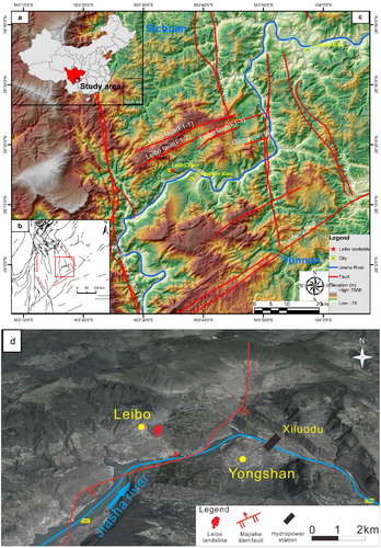
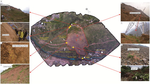
At 5:00 am, on 2 July 2017, a landslide (located at latitude 28°15′40.61″N and longitude 103°34′43.82″E) took place in the Nantian town, on the left bank of the Eastern Gully, about 1.0 km immediately east of Leibo county, Liangshan, Sichuan, southwestern China (hereinafter called Leibo landslide) (). The Beltway (under construction), houses and cultivated land nearby were seriously damaged. Based on a comprehensive investigation, geomorphological and geological features of the Leibo landslide are clarified and the failure mechanism and evolution processes are proposed. The study presents an ideal case for achieving a better understanding of landslides and preventing geological hazards in mountainous areas.
Figure 1. Generalized location map and tectonic setting of the Leibo landslide. (a) Location of study area. (b) The tectonic setting of study area. (c) Geographic position and region of the Leibo landslide. (d) The geomorphologic map of the study area. Source: Author.
2. Geographical and geological settings
2.1. Geomorphology
The Leibo landslide occurred in a region of the east rock area of the distribution of Emeishan basalt (Lin Citation1985), located at a distance of approximately 1.0 km from Leibo County centre and situated at the Leibo–Yongshan tectonic basin, which is a tectonic erosion topography in the high-alpine gorge where the eastern part of mountains is generally higher than the western part, and, which is the southwestern margin of the Yangtze platform. The site is located on the east bank of Eastern Gully (), with an aspect of 240° and a terrain gradient of 30°, respectively. The upper slope forms a gentle platform due to the early slide in this area.
2.2. Geology and structure
The study area is located on the Mabian seismotectonic zone, which belongs to the Yangtze Craton. Leibo fault zone and Majiahe dam reverse fault are the major structures (). The Leibo fault zone consists of three nearly parallel Northeast-Eastward secondary faults. The faults composition, from north to south, is the north branch fault (F1-1), the middle branch fault (F1-2) and the south branch fault (F1-3), which constitute a total length of 35 km and width of 10 km NEE fault zone (Han et al. Citation2009). The Majiahe dam fault here strikes NE with 17 km in length and 5 km in width, can be split into front thrust compression zone, middle subduction shear zone, east oblique reverse fault–strike–slip shear zone, west normal fault strike–slip zone and rear tectonic deformation zone, with curves as ‘W’ shape in the plane and ‘S’ shape in the profile (Liu et al. Citation2006).
The landslide area is located at the western limb of the Yongsheng syncline. The main outcropping rock formations in the study area are the three set of Lower Permian Yangxin limestone (), Upper Permian Emeishan basalt (
and quaternary deposits (
). A detailed investigation description of the stratigraphy of the slope at the Leibo landslide site of the two members is ulteriorly given in . The rock masses in the landslide area appear a perplexing and intensely inhomogeneous structure, result from the existence of pervasive jointing ().
Figure 2. The outcrop fractured basalt rock mass. (a) Reticular fissures of basalt rock mass. (b) Weathered basalt. Source: Author.
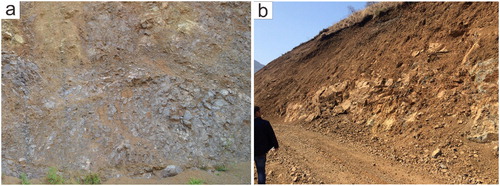
Table 1. Detailed descriptions of stratigraphy in the study area.
2.3. Hydrology and rainfall
The current climatic conditions in the study area are featured as a mean daily temperature between 12.0 and 19.7 °C and annual precipitation of 580–850 mm. Rainfall occurs during the monsoon from (April to October) and contributes about 90–96% of the total annual rainfall. Heavy rainfall is mainly concentrated from June to August.
2.4. Anthropogenic activity
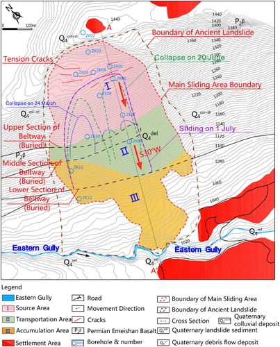
Anthropogenic activities include road construction, urban development, blasting and mining which adversely impact the stability of the terrain. A three-section beltway has been built since August 2016 over the slope (), which is 7.76 km in length, and 8.5 m in width. The elevation of the upper, middle and lower sections of the beltway is 1230, 1205 and 1120 m, respectively. Because of the excavation, the angle of response of the slope has been destabilized.
Figure 3. Geological map of the Leibo landslide. Source: Author.
3. Methodology
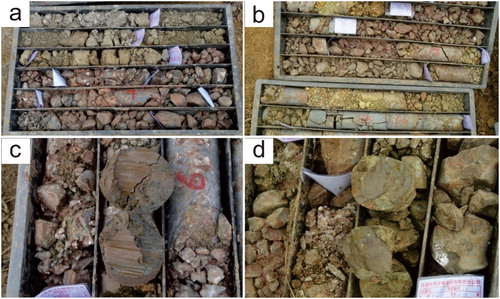
We used a combination of field mapping, photographic interpretation, detailed in situ investigation followed by analyzing the data GIS environment. The extent and features of the landslide were mapped using topographic data and images from the following: 2.5 m resolution digital elevation model (DEM) derived from GPS measure, an orthomosaic map produced from UAV survey. Ground characteristics of the landslide were identified and measured in the filed using handheld GPS and total stations, which recorded the geometry of each zone and its deformation parameters. Field investigations at the landslide site consisted of borehole drilling and exploratory trench test and coring of undisturbed soil and rock samples to comprehend the material structure and identify the slip surface.
4. Results
4.1. Geometry
Field reconnaissance of the Leibo landslide has revealed that the entire area is an ancient landslide zone whereas the reactivated zone is concentrated in the upper part. The bedrock is comprised of Permian basalt intercalated with tuff, and the strata of the rock layer is N35°W∠NE20° (). The Leibo landslide would be described as a rotational debris slide (Cruden and Varnes Citation1996; Hungr et al. Citation2014), which is characterized by rapidly moving, retrogressive failure of debris on a moderately inclined slope. The landslide has an irregular shape, with a length of 510–710 m and a width of 350–410 m, having an area of 22 ha, and extends from an elevation of 1420 m down to 1020 m. The sliding direction generally followed S30°W. The average depth of the sliding mass reached 35 m, hence it can be considered as a deep-seated landslide (DZ/T0218-2006).
Figure 4. Main geological longitudinal profile (A–A′) of the Leibo landslide along the main movement direction. Source: Author.
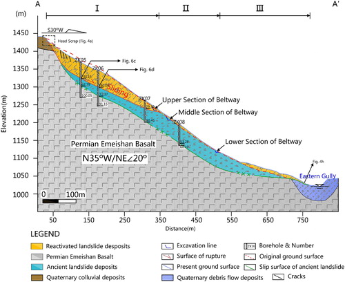
Based on Burbank et al. (Citation1996), the average effective angle of internal friction of 32° is the threshold for landsliding in the fractured rock which controls hillslope stability. At the study area, the gradient of the upper, middle, lower part of the landslide is 5°, 35°–37°, 15°–20°, respectively, that could build a perfect environment for landslide under internal–external agency. Based on the location of the shear outlet and features of mobility and deposits, the landslide was divided into three zones (): the source area, transportation area and the accumulation area. and illustrate the scope of the Leibo landslide and zones.
4.2. Destruction and deformation characteristics
The landslide is caused by the failure of densely jointed and weathered basalt in the source area of approximately 4.03 Mm3. The movement initiated from the middle part of the slope, retrogressing to the upper part-gentle slope platform, eventually decelerated and started to accumulate below the elevation of 1150 m.
4.2.1. Source area (Area I)
The source area is located at the rear platform of the ancient landslide body. The head scarp and the toe of the sliding surface are located around 1420 and 1240 m, respectively. The source area has a length of 300 m along the sliding direction, 360 m transversally and an area of 9.6 × 10⁴ m2 ( and ). The slide mass comprised of unconsolidated ancient landslide deposits and fractured Permian basalts (. Borehole core logs revealed that the maximum thickness of slide mass is about 76 m and its estimated volume is 3.03 Mm3. At the posterior of sliding mass, the exposed main crown scarp appeared as a ‘Wave’ shape with distinct indications of slip displacements, vertical dislocation of up to 15 m and a width of 230 m along the direction of 70° SE and a slope angle of about 50°–60° (), which indicated the occurrence of conspicuous downhill displacements. Tension cracks measured to be 20–30 cm deep and quintessentially 5 m in length, were prevalent on the slope surface.
Figure 5. The aerial photograph of Leibo debris slide. (a) The headscarp on the trailing edge reaches 10–15 m. (b) The outcrop of sliding bed. (c) The outcrop sliding surface descended from the fresh scarp on the upper slope. (d) The ancient landslide deposits can be observed on the right lateral margin. (e and f) The electronic transmission tower was damaged. (g) The debris particles with different sizes of blocks observed in the accumulation area of the landslide. (h) The sliding body blocked the Eastern Gully. Source: Author.
4.2.2. Transportation area (Area II)
The transportation area is 50–190 m long and 430 m wide in the middle part of the slide (). The detached rock mass accelerated due to the steep gradient of 35° in this area, with a thin deposited structure of about 5 m, an area of 5.4 × 10⁴ m2 and a volume of 30 × 104 m3, mainly comprised of boulder and blocks, which were inferred to derive from the source rock mass for their fresh and completely-strongly weathered, contrasted with the ancient landslide deposits ( and ).
4.2.3. Accumulation area (Area III)
The displaced materials moved down along the slide direction and eventually mainly deposited in the lower part of slope with elevations ranging from 1115 to 1020 m and length of 220–330 m having an area of 7.0 × 10⁴ m2 ( and ). The slide mass comprised of highly weathered angular rubble, gravel soils and displaced basalt rock blocks () with a thickness of 5–10 m having a volume of 70 × 104 m3. This area has a longitudinal gradient of 20°. Geologic cross-sections along the centerline of the Leibo landslide are indicated in .
The presence of a shear surface is generally considered to be evidence of a slip plane (Hutchinson and Bhandari Citation1971; Alonso et al. Citation1993; Corominas et al. Citation2005). A clear slickenside surface resulted from frictional movement between rocks along two sides was seen ( and ). The slip zone is composed of grey-green breccia debris and gravel breccia mud, with particle size ranging from 0.2 to 2 cm. The interlayer and intraformational disturbed belts of the basalt are thus regarded as the sliding surface of the landslide. The outcrop descended from the fresh scarp on the upper slope also showed that this belt is the sliding surface of the rockslides ().
Figure 6. Typical borehole imageries of borehole drilled at the slope. (a and b) Materials of grey-green breccia debris and gravel breccia mud of slip zone from the ZK01 and ZK04. (c and d) Clear sliding surface from ZK05 and ZK06 (location inferred in ). Source: Author.
4.3. Failure mechanism of landslide
The mechanisms of Leibo landslide failure sequence presented here are predominately derived from reconnaissance observations and geological analysis. shows the failure mechanism sketch of Leibo landslide. Based on the field observations, it can be suggested that there are three stages of Leibo landslide movement (). In the first stage, with the heavy rainfall, the ancient landslide whose slip surface was intensely weathering-intermediate weathering interface of basalt formed. Prior to the Leibo landslide, the subsurface materials beneath slope as well as the surface itself were likely composed of failed blocks of landslide sediments derived from the remoulding of these materials from the ancient landslide, and initial cracks formed in the phase of ancient landslide formation. As a consequence, the resistance to sliding force was reduced ().
Figure 7. Cross section A–A′ showing failure sequence. The location of the cross-section is shown in . (a) Pre-Leibo landslide topography and stage 1. (a-1 and a-2) Three stages beltway excavating on the slope. (b) Stage 2. (b-1) Local sliding occurred on 24 March. (b-2) A new local sliding occurred on 20 June. (c) Stage 3. (c-1 and c-2) Overall sliding occurred on 2 July. (d) Post-Leibo landslide topography. (d-1) The sliding mass tended to be equilibrium. Source: Author.
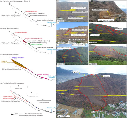
Table 2. Deformation process of Leibo landslide.
Secondly, after the upper section of the beltway’s excavation passed through the ancient landslide body, the free face was expanded, in response to the unloading from excavating and the redirection of principal stresses, the anti-sliding force was further dropped, and the local cracks further extended. As a result, the local collapse of soil mass occurred (). The second stage of the movement is described as partial slumping due to the excavation of the beltway. Stage 2 was comprised entirely of precious landslide deposits. The electronic transmission tower at the rear of slope did not fall during this stage, which was interpreted to not completely sliding of the slope (). However, this stage removed support from the upper half of the ancient slide mass (see ).
Figure 8. The electronic transmission tower remains unchanged in the gentle platform which above the landslide boundary. The overall sliding reaches the left boundary on 2 July 2017. Source: Author.
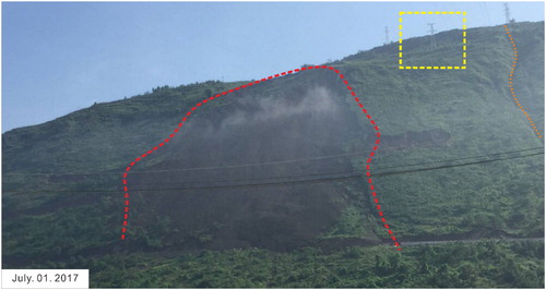
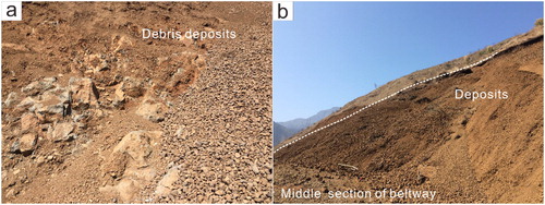
Figure 9. Displaced materials of the debris slide. (a) Debris sliding deposits and fragmented basalt rock. (b) The local sliding deposits in the middle section of beltway on 24 March. Source: Author.
Ultimately, the cracks in the slope were filled up by infiltration water because of the heavy and prolonged rainfall during July 1 to July 2, which caused the cracks propagating, pore water pressure growing and shear strength dropping of the slope, then cohesion loses and effective friction angle on sliding belt decreased saliently on wetting state, resulting in overall sliding (Goodman and Kieffer Citation2000; Iverson Citation2000; Iverson et al. Citation2015) (). We interpret the third stage to have occurred soon after responding to the unloading from the former stage and the succeeding rainfall. The observation of the dumping of electronic transmission tower and trees support the interpretation. Furthermore, the fragile geological structure facilitated the slide occurrence. Due to completely-highly weathering effect, such a small-scale excavation could induce the resurgence of a large landslide.
Owe to the splendid decision-making and deliberate evacuation, no one was hurt. However, there was still economic loss caused by the Leibo landslide.
4.4. Evolution process of landslide
The road excavating is the main driving factor induced the reactivation of the ancient landslide. Excavation helped trigger the landslide through exposing geological structures on the free surface and by unloading the toe of the slope (Stark et al. Citation2005). The multi-excavation with high and steep cut slopes can be observed along the beltway (. Field investigation prior to excavation presented that the original slope was stable. The local and entire failure demonstrated that the excavation had a direct impact on the stability of slope by unloading of the cut slope and redistributing of the stress. Additionally, road intercepted subsurface flow from cut slope during storms and concentrated overland flow on their paved surfaces. Therefore, the resistance sliding force of slope was reduced, gravity-induced slope failures occurred on the cut slope. In addition to the road excavating, the subsequent rainfall is very significant, if not dominant, which accelerate the resurgence of the ancient landslide markedly. It is generally recognized to date that rainfall increased slope gravity, water content, as well as the pore water pressure, whilst it decreased the physical and mechanical properties of the materials of the sliding body (Iverson Citation2000; Xu et al. 2012b; Ma et al. Citation2018).
The peculiarity of the landslide depends on its minor-scale excavation induced reactivation of large-scale landslide, implying that the fragile geological structure conditioned landslide formation. The occurrence of large and damaging road-induced landslides appears rather commonplace along excavated mountain roads in this region where bedrock has been sheared, folded and fractured during tectonic uplift and weathering (Sidle et al. 2011). Sharifzadeh et al. (Citation2010) emphasized that the steep angle of slope face, the fault plane and the weight of the overlying alluvium material, low shear strength of the rock mass and the saturation of the rock mass were the main contributing factors of the excavated slope failure. Emberson et al. (2016) proposed that localized weathering was associated with deep-seated landsliding, to which these slopes are prone. They concluded that mountain weathering is sensitive to climatic and tectonic controls on mass wasting processes.
Generally, basalt is characterized by hardness, integrity, strong weathering resistance and high strength, which is suggested as the foundation of a hydropower project in both upper and lower reaches of the landslide area. Nonetheless, basalt presents the characteristics of fragmented, high weathering degrees and low strength in the study area as aforementioned, with the underlying limestone also exhibits the same characteristics, which can be excavated merely with excavators. The materials of the source area, accumulation area and sliding bed were rubbles and gravels of basaltic rock and several large boulders (2–30 cm in size) ( and ). Particular attention was paid to the geological and geomorphological features in order to explain how such a small-scale excavation resulted in a large-scale landslide. A detailed analysis of the causes is included in the following paragraphs.
The landslide area is located on a nearly three-sided closed tectonic plate called the Leibo–Yongshan Triangle, which is surrounded by the northwestern Zemuhe fault in the west, the northeastern Lianfeng fault in the southeast and the northwestern Mabian-Daguan fault in the northeast. The closed block, in which the stress is concentrated and locked, the seismic activity is frequent due to the local strain imbalance of the tectonic stress field. Thus, the terrain in the area is undulating and the erosion is very strong, also, the basalt rock mass in the fault zone is fractured. Moreover, the study area is located in the middle subduction shear zone of the Majiahe dam reverse fault. This zone has a main section that tends to SE, with a dip angle of 9°–12°, which presents a broadly undulating shape. The fault consequently developed in the Yanxin limestone on the left bank of the Jinsha River, caused the limestone rock mass on the hanging wall was broken and fragmented (known locally as ‘Bubble limestone’) (Zhu Citation2001). As a result, the overlying Emeishan basalt was also presently fragmented (). In the phase of the neotectonic Himalayan movement, the study area underwent strong tectonic movement and the contemporary compressive stress-oriented NWW. This movement laid the foundation for the hodiernal characteristics of geological structures and structural planes. Compressive structural planes in basaltic rock are well developed from the original basalt flow surfaces on the western limb of the Yongsheng syncline.
At present, the academic community believes that the formation and development of basalt columnar joints are related to the condensation and shrinkage of the lava flow level, and are also affected by the rock type, magma eruption method and eruption environment. The eruption environment in the east rock area is a continental eruption, and the internal material composition of the rock formation is relatively uniform, which is favourable to form columnar joints. Therefore, the columnar joints of basalt in the location of Leibo landslide are well developed. Basalt columns cut by columnar joints develop dense structural fractures in diverse directions due to the tectonic movements. The primary structural plane in the basalt-columnar joint and structural planes-the interlayer and intraformational disturbed belts and matrix cracks together caused the fragmented structure of the sliding body, which explained the forming mechanism of rubbles with the particle size of 2–30 cm of the sliding body.
Exposure of fresh rock surfaces by fragmented structure can promote efficient chemical weathering (Huh et al. Citation1998). In the context of long-term weathering, retiform shape fissures are well developed throughout the basaltic rock mass (). Rock weathering can control the progressive failure of a slope (Agliardi et al. Citation2001; Martin et al. Citation2011). In the rock slope, the weathering of the basalt rock mass is completely-highly and extends over 30 m in depth. illustrates the appearance of the weathering observed in rock outcrops of basalt. Completely-highly weathering developed in porphyritic basalt whose content of feldspathic crystals is generally 10–15%. The feldspathic crystals in the fractured rock mass were kaolinized by groundwater. The strength of basalt rocks was reduced and the homogeneity of basalt was damaged due to the existence of feldspathic crystals, which caused basalt rock mass was susceptible to fracture. As a consequence, the basalt rock mass has gradually softened and the shear strength of the rock structural planes has dramatically decreased.
The interlayer and intraformational disturbed belts in the basalt layer exert a strong influence on landslide stability. Permian Emeishan basalt is volcanic rock spewed and overflowed numerous times in many stages and has many rhythmic cycles. Fourteen rock flow layers have been formed after several volcanic eruptions (Lin Citation1985). Based on the field reconnaissance, the slip zone of Leibo landslide is a dislocation zone of lithic gravel type developed in the porphyric basalt. Chai (Citation1999) concluded that the weathering degree of intraformational disturbed belts in the lithic gravel type is generally one level deeper than that of rock masses. Thus, a shear sliding surface can be readily formed along with the disturbed belts.
It is also relevant to consider that early sliding of the ancient landslide was conducive to the sensitivity of the slope. Semenza and Ghirotti (Citation2000) suggested that the existence of the ancient landslide played a vital role in the occurrence of the 1963 Vaiont slide. Apparent identification geomorphological evidence can be found in the northern part of the slope that presents a lateral boundary of the ancient landslide, Meanwhile, the topography became gentle in the upper part of the slope, with a slope angle of 5°–10°, and was developed into the farmland, which was usually attributed to landslide.
5. Conclusions
The landslide is a typical large-scale retrogressive debris slide reactivated by road excavation and rainfall. The main deformation characteristics, failure mechanism and evolution process have been studied. The primary conclusions are summarized as follows.
The Leibo landslide is a deep-seated debris slide, which consists of three zones: source area, transportation area and accumulation area due to geomorphology and material structure, and, reactivated by beltway excavation and precipitation with devastating effect in 2017.
Data from field investigation and aerial photographs provide evidence of multiple stages of failure, with the first stage including the initial cracks formed and the second containing a local collapse of soil mass, while the third stage involving retrogression of the debris slide into the gentle slope platform.
The study area is located in Emeishan basalt strata which are formed by several stages of magmatic activities, whose columnar joints are well developed. The weak characteristics of the interlayer and intraformational disturbed belts in the rock flow layer play a key role in the stability of landslide. The landslide area lies in the hanging wall of faults zone, and the severely weathered rock mass into account, in conjunction with the slide of the ancient landslide in the early stage, the materials composition is fragmented. The recently multi-stage road excavation disturbance leads to landslide revival. The occurrence of Leibo debris slide is closed pertinent to geological, geographical and rock mass mechanical conditions.
Acknowledgements
The authors thank Dr. Mohammad Rezania of University of Warwick, United Kingdom for him constructive advices and language editing.
Disclosure statement
No potential conflict of interest was reported by the authors.
Additional information
Funding
References
- Agliardi F, Crosta G, Zanchi A. 2001. Structural constraints on deep-seated slope deformation kinematics. Eng Geol. 59(1–2):83–102.
- Alonso EE, Gens A, Lloret A. 1993. The landslide of Cortes de Pallas, Spain. Geotechnique. 43(4):507–521.
- Banerjee P, Ghose MK. 2016. Spatial analysis of environmental impacts of highway projects with special emphasis on mountainous area: an overview. Impact Assess Project Appraisal. 34(4):279–293.
- Burbank DW, Leland J, Fielding E, Anderson RS, Brozovic N, Reid MR, Duncan C. 1996. Bedrock incision, rock uplift and threshold hillslopes in the northwestern Himalayas. Nature. 379(6565):505–510.
- Chai HJ. 1999. Study on rock mass structure model and engineering application of Xiluodu hydropower station on Jinsha river. China: Chengdu University of Technology. (in Chinese)
- Corominas J, Moya J, Ledesma A, Lloret A, Gili JA. 2005. Prediction of ground displacements and velocities from groundwater level changes at the Vallcebre landslide (Eastern Pyrenees, Spain). Landslides. 2(2):83–96.
- Cruden DM, Varnes DJ. 1996. Landslides types and processes. In: Turner AK, Schuster RL, editors. Landslides: investigation and mitigation. Special Report 247. Washington, DC: Transportation Research Board, National Research Council; p. 36–75.
- Emberson R, Hovius N, Galy A, Marc O. 2016. Chemical weathering in active mountain belts controlled by stochastic bedrock landsliding. Nature Geosci. 9(1):42–45.
- Goodman RE, Kieffer DS. 2000. Behavior of rock in slopes. J Geotech Geoenviron Eng. 126(8):675–684.
- Han ZJ, He YL, An YF, Li CY. 2009. A new seismotectonic belt: features of the latest structural deformation style in the Mabian seismotectonic zone. Acta Geol Sin. 83:218–229.
- Huang D, Gu DM, Song YX, Cen DF, Zeng B. 2018. Towards a complete understanding of the triggering mechanism of a large reactivated landslide in the Three Gorges Reservoir. Eng Geol. 238:36–51.
- Huang R, Fan X. 2013. The landslide story. Nature Geosci. 6(5):325–326.
- Huang RQ. 2009. Some catastrophic landslides since the twentieth century in the southwest of China. Landslides. 6(1):69–81.
- Huh Y, Tsoi M-Y, Zaitsev A, Edmond JM. 1998. The fluvial geochemistry of the rivers of Eastern Siberia: I. Tributaries of the Lena River draining the sedimentary platform of the Siberian Craton. Geochim Cosmochim Acta. 62(10):1657–1676.
- Hungr O, Leroueil S, Picarelli L. 2014. The Varnes classification of landslide types, an update. Landslides. 11(2):167–194.
- Hutchinson JN, Bhandari RK. 1971. Undrained loading, a fundamental mechanism of mudflows and other mass movements. Geotechnique. 21(4):353–358.
- Iverson RM. 2000. Landslide triggering by rain infiltration. Water Resour Res. 36(7):1897.
- Iverson RM, George DL, Allstadt KE, Reid ME, Collins BD, Vallance JW, Schillinga SP, Godtd JW, Cannone CM, Magirlf CS, et al. 2015. Landslide mobility and hazards: implications of the 2014 oso disaster. Earth Planet Sci Lett. 412:197–208.
- Lin JY. 1985. Spatial and temporal distribution and geological characteristics of Permian basalt series in three provinces of southwest China. Chin Sci Bull. 30(12):929–932. (in Chinese)
- Lindner G, Schraml K, Mansberger R, Hübl J. 2016. UAV monitoring and documentation of a large landslide. Appl Geomat. 8(1):1–11.
- Liu NN, Liu WL, Wu DC, Wang DY, Gu M. 2006. A thrust fault in a hydropower plant reservoir region in the southwest China. J Eng Geol. 14(1):13–17. (in Chinese)
- Ma G, Hu X, Yin Y, Luo G, Pan Y. 2018. Failure mechanisms and development of catastrophic rockslides triggered by precipitation and open-pit mining in Emei, Sichuan, China. Landslides. 15(7):1401–1414.
- Martin CD, Alzo'ubi AK, Cruden D. 2011. Progressive failure mechanisms in a slope prone to toppling. Proceedings Slope Stability 2011: International Symposium on Rock Slope Stability in Open Pit Mining and Civil Engineering; Sep 18–211; Vancouver, Canada (Paper 265).
- Peternel T, Kumelj Š, Oštir K, Komac M. 2017. Monitoring the Potoška planina landslide (NW Slovenia) using UAV photogrammetry and tachymetric measurements. Landslides. 14(1):395–406.
- Rossi G, Tanteri L, Tofani V, Vannocci P, Moretti S, Casagli N. 2018. Multitemporal UAV surveys for landslide mapping and characterization. Landslides. 2:1–8.
- Semenza E, Ghirotti M. 2000. History of the 1963 Vaiont slide: the importance of geological factors. Bull Eng Geol Environ. 59(2):87–97.
- Senthilkumar V, Chandrasekaran SS, Maji VB. 2018. Rainfall-induced landslides: case study of the Marappalam landslide, Nilgiris district, Tamilnadu, India. Int J Geomech. 18(9):05018006.
- Sharifzadeh M, Sharifi M, Delbari SM. 2010. Back analysis of an excavated slope failure in highly fractured rock mass: the case study of Kargar slope failure (Iran). Environ Earth Sci. 60(1):183–192.
- Sidle RC, Furuichi T, Kono Y. 2011. Unprecedented rates of landslide and surface erosion along a newly constructed road in Yunnan, China. Nat Hazards. 57(2):313–326.
- Stark TD, Arellano WD, Hillman RP, Hughes RM, Joyal N, Hillebrandt D. 2005. Effect of toe excavation on a deep bedrock landslide. J Perform Constr Facil. 19(3):244–255.
- Wartman J, Montgomery DR, Anderson SA, Keaton JR, Benoît J, Dela Chapelle J, Gilbert R. 2016. The 22 March 2014 Oso landslide, Washington, USA. Geomorphology. 253:275–288.
- Xu G, Li W, Yu Z, Ma X, Yu Z. 2015. The 2 September 2014 Shanshucao landslide, Three Gorges Reservoir, China. Landslides. 12(6):1169–1178.
- Xu Q, Fan X, Dong X. 2012a. Characteristics and formation mechanism of a catastrophic rainfall-induced rock avalanche–mud flow in Sichuan, China, 2010. Landslides. 9(1):143–154.
- Xu Q, Shang Y, van Asch T, Wang S, Zhang Z, Dong X. 2012b. Observations from the large, rapid Yigong rock slide – debris avalanche, southeast Tibet. Can Geotech J. 49(5):589–606.
- Zhang F, Liu G, Chen W, Liang S, Chen R, Han W. 2012. Human-induced landslide on a high cut slope: a case of repeated failures due to multi-excavation. J Rock Mech Geotech Eng. 4(4):367–374.
- Zhang M, McSaveney M, Shao H, Zhang C. 2018. The 2009 Jiweishan rock avalanche, Wulong, China: precursor conditions and factors leading to failure. Eng Geol. 233:225–230.
- Zhao Y, Huang Y, Liu H, Wei Y, Lin Q, Lu Y. 2018. Use of the normalized difference road landside index (NDRLI)-based method for the quick delineation of road-induced landslides. Sci Rep. 8(1):17815.
- Zhao Y, Xu M, Guo J, Zhang Q, Zhao H, Kang X, Xia Q. 2015. Accumulation characteristics, mechanism, and identification of an ancient translational landslide in China. Landslides. 12(6):1119–1130.
- Zhu JL. 2001. A study on the isolated rock mass stability of the Majiaheba upper wall, Xiluodu hydroelectric station. China: Chengdu University of Technology. (in Chinese)