
ABSTRACT
This study aimed to develop an assessment tool for determining the geographic inquiry process skills of 9th-12th grade high school students. A 36-item questionnaire was prepared to achieve this goal. The questionnaire was administered to 599 10th and 11th-grade students from five different school types in Ankara province of Turkey in 2019. In consequence of the exploratory and confirmatory analyses, the scale consisted of 22 items and 5 factors. These factors were named Posing Geographic Questions, Acquiring Geographic Information, Organising and Analysing Geographic Information, Answering Geographic Questions, and Communicating Geographic Information. The findings show that the scale is valid, reliable, and discriminative.
Introduction
In the 21st century, humanity has set out to confront problems that have greater and global impacts than it has ever experienced in its history, and often to develop new ways for addressing and finding solutions to the problems it has faced. Today, in order to understand the changing and complex structure of the world and find solutions to the problems that are faced by mankind, individuals with skills and competencies are needed. For this reason, people have started to focus on skills-based training based on innovative approaches and technologies, creating meaningful and effective learning environments today. With skill-based teaching, students are expected to be raised as good citizens who are sensitive to the world they live in and to the social, economic and environmental problems they encounter, take responsibility for solving problems, analyse, synthesise, evaluate, use their creativity and abilities, ask and question, and have 21st-century skills. Today, the world needs individuals who ask, question, investigate the underlying reasons of the events, and are equipped with 21st century skills and competencies. Based on this need, one of the expected objectives of education in recent years has been the realisation of inquiry-based learning by students.
It is not possible to make a precise, complete, and common definition of inquiry due to its use in different disciplines and fields of practice in everyday life. However, inquiry is considered in theLiterature both a skill and a process and a learning-teaching approach (Vajoczki, Watt, Vine, & Liao, Citation2011). This approach is student-centred. It feeds on active learning approaches and Constructivist theories. Questions form the starting point of the approach. Inquiry begins with defining a problem and covers a teaching process in which students learn discipline-specific skills and practices, as well as content, by following a series of steps to achieve a solution to this problem (Hmelo, Duncan, & Chinn, Citation2007, p. 100). There is no stereotypical structure related to the application of the approach in the educational environment. It is implemented in conjunction with various teaching models. For this reason, inquiry is shaped according to applications performed in or outside the classroom depending on the question. In the inquiry-based approach, instead of strict rules and formulas to follow, there are many basic questions, methods, and techniques. In the approach, the student is encouraged to self-learn, that is, to learn by doing. Rather than accepting the information presented, students actively participate in the process of interpretation of information by being involved in what they will learn. In this aspect, the inquiry-based approach can also be considered as the process of obtaining and interpreting information by living and using that information. In this approach, students are encouraged to ask questions, collect the data to answer the question, analyse and learn by finding solutions to the questions by these analyses. The main objective of the approach is to prepare the student for lifelong learning (Kidman & Casinader, Citation2017, p. 68). By applying this approach in and out of the classroom, students continue to develop in all aspects, taking the initiative for their learning. They grow up as individuals who learn to learn.
Participation in inquiry allows students
To learn related topics,
To gain general inquiry skills,
To develop field-specific skills,
To make field-specific generalisations,
To develop concepts. But the skill that is expected to develop first in students is the ability to conduct an inquiry (Edelson, Gordin, & Pea, Citation1999).
Inquiry skills are common skills used by all disciplines and are not only specific to geography. Despite this, the feature that makes an inquiry geographic and distinguishes it from the inquiries of other sciences is the discipline-specific questions. Therefore, when inquiry skills are used to find answers to geographic problems and questions, they are considered geographic inquiry skills. Rawling (Citation2000) defines geographic inquiry as an active approach, which is based on asking questions and includes geographic skills and values. For this reason, geographic inquiry skills are important in geography education, as they are a prerequisite for the realisation of other geographical skills, values, and attitudes.
The scientific steps used in inquiry in geography education consist of five stages in general. These steps are called geographic inquiry skills or geographic skills. These are;
Posing Geographic Questions,
Acquiring Geographic Information,
Organising Geographic Information,
Analysing Geographic Information,
Reaching Geographic Conclusions and Explaining (Geography Education National Implementation Project [GENIP], Citation2012).
The inquiry process begins with the development of a sense of curiosity as a result of the student being left in a difficult and complex situation, at odds with their previous knowledge and experience (Roberts, Citation2013; Spronken-Smith, Bullard, Ray, Roberts, & Keiffer, Citation2008). Along with this sense of curiosity, students begin to ask questions about the subject that they are studying. Then, they begin to make a plan, that is, to design a process, to investigate the answer to the question asked in the inquiry. The first question that students will ask in order to get information about the location and place during the geographic inquiry process is “Where?” In order to establish a cause-and-effect relationship, they ask “Why and Why is there?”. With these questions, students observe the interaction and relationships between places and people, looking for answers to why they are there. Questions on place, space, and location information, such as “Do they have aspects that are similar to other places? How are they related to other places?” “What does this place look like?” are some examples of geographic questions. Through such questions, students learn the positions, distributions, and relationships of objects, events, and facts (Karabağ, Citation1998).
In the geographic inquiry process, the use of questions that addresses the value of geography, such as, “what will be in the future?”, “what is the decision that’s been given and what is the effect of that decision?”, “what do I think?”, “what should one do?”. These questions should be in a way that creates a conflict of value to the student. They help students use a geographic perspective to understand the world they live in and develop a geographic perspective (Slater, Citation1982; Roberts, Citation2003 from 16 to 19 Scholl Council Project; p. 22).
In addition, questions established with question words such as “who, what, how, how should it be, which, in what way” in relation to a topic or problem with a geographic aspect, as well as questions related to the future, such as “how would it be if this were the case?” are also treated as geographic questions. With these or similar questions, students continue to gain geographic inquiry skills by making inferences about life in the present and future, and creating models.
For example,
How can the factors that cause bushfires, floods, and droughts in Australia be eliminated?
How would human life continue if the world had not experienced the geological periods?
Questions such as these, which are asked both in the past and in the future, are geographic questions that the students of 21st century are expected to find answers or that cover the basic concepts of geography. These and similar questions, which include the basic concepts of geography, also make an inquiry geographic, separating it from the inquiries of other sciences. As mentioned earlier, questions are a prerequisite for an inquiry. Students begin to search for information as a result of these questions asked in a geography course. During this process, the source of information and the methods of obtaining information that the student will collect vary. A student sometimes collects an animal fossil in a field study, and sometimes obtains data using GPS to determine the location of plant species. He/she sometimes accesses the information he/she needs by reading and interpreting an already existing map, data, and satellite image; or the student answers the question using the survey, interview, and observation method with fieldwork; or he/she measures the flow of a stream or examines the dirty water he/she receives from the lake in a laboratory environment. He/she investigates the causes and consequences of pollution in a lake by various methods. The analysis method will differ according to the data collected by the student and the data collection method. What is important here is that students determine the distribution of the event or phenomenon, establish a cause-and-effect relationship with the event or phenomenon, make a decision about the result, and try to create a solution by predicting the possible future consequences of this result. Therefore, what is key is not that students reach a definitive solution to the question, but develop skills that they can use when investigating, analysing, and interpreting the problem. Depending on the questions asked, students would collect and analyse data in different ways each time and reach different results. As can be understood from above, geographic inquiry brings a different approach to the geographical way of thinking and the inquiry process based on the content of each subject. Therefore, the type of questions, collected information, evidence and/or data, and the applied method of analysis varies according to the subject of inquiry. For this reason, it is not a prerequisite for performing all the above-mentioned steps in order in an inquiry process. Although all steps are normally followed in the inquiry process, in certain circumstances some steps can be skipped or their order can be changed depending on the content of the study (Schell, Roth, & Mohan, Citation2013), or only one step can be used. Some inquiries start from the first step and continue sequentially to the last step, or in some others, some steps are omitted, they start from another step and continue to the last step. This varies depending on the subject content, environment, time, and level of students in the inquiry process. Therefore, what is important in inquiry is that the inquiry process and learning environment are organised in such a way that students will take their own responsibilities over time.
In other words, a student’s inquiry skills would develop by means of the organisation of the inquiry-based learning environment and the inquiry process in accordance with the student. Creating an effective inquiry environment and carrying out the inquiry process flawlessly with regard to the student is only possible by measuring students with various methods and techniques. Therefore, tools to measure inquiry skills are required in order to understand the current status of the students regarding these skills and to monitor the course of their development. One of these measurement tools is the self-efficacy scales that are used to determine students’ beliefs about their level of achieving a task. Kan (Citation2014, p. 88) defines self-efficacy as an individual’s self-perception, belief, and judgement regarding his/her ability to cope with different situations and achieve a certain activity. In this type of scale, evaluation is made according to the information as provided by the individual. This information as provided by the student about oneself is important in education because it gives information about both the level of achieving that task in the past and one’s motivation for performing that task in the future. An individual’s own experience is one of the most effective sources in the formation of a strong self-efficacy belief in individuals. In that respect, it seems likely that as the students’ experience of performing the skill increases, their self-efficacy levels would increase, and their self-efficacy levels would decrease as their experience of performing the skill decreases. In addition, student’s self-efficacy perception is an element that directly affects their motivation and success in learning. Self-efficacy has the potential to affect the individual’s motivation for performing that job, the time spent to perform the job, his/her performance, and the individual’s behaviour. In that respect, information on a student’s self-efficacy may serve as an indicator for understanding his/her performance and behaviour in the inquiry process as well as his/her past experiences regarding the skill. Based on what has been mentioned so far, it is suggested that measuring self-efficacy would be useful in predicting the behavioural results of a student during the inquiry process. Therefore, it is necessary to know the self-efficacy of the student in performing the inquiry.
The transformation that started in geography education in Turkey beginning from the early 2000s reached to a new understanding upon the introduction of Geography Curriculum (GC) in 2005. Pursuant to the program, a skill-based approach has been adopted in order to raise individuals who are equipped with geographical knowledge and skills, and who ask questions and engage in inquiry (MEB, Citation2005). In this scope, geographical inquiry skill was determined in the GC as one of the eight geographical skills (MEB, Citation2005, Citation2018) to be acquired by students. Based on these developments in Turkey, the teachers continue to help their students with acquiring geographic inquiry skills, using a variety of methods and techniques across the learning environments. Therefore, it was necessary to develop a self-efficacy scale in order to understand both the past experiences of students in a geographic inquiry and the performance they would demonstrate in geographic inquiry skills in new studies. It is believed that this scale would contribute to teachers’ recognition of their students and, as a result of this recognition, provide the support that their students need by organising effective and correct learning environments.
We aimed to develop a valid and reliable measurement tool to measure students’ self-efficacies in their geographic inquiry skills. Based on this, the purpose of the study was to develop a valid and reliable assessment tool to measure “9th-12th grade students’ self-efficacies on geographic inquiry process skills”.
As a result of all the analyses in the study, it is possible to say that a valid and reliable assessment tool, which has a high sensitivity, discriminative, valid, and reliable in detecting students’ geographic inquiry process skills, was developed.
It is recommended that the developed scale be used to measure the geographic inquiry skills of students in the educational process.
In this study, after the introduction section, the research method (data set and method) is explained and then the findings of the research on validity and reliability are provided. In the conclusion section, the results and suggestions obtained from the findings are discussed.
Data set
The research is a scale development study. The aim of the study is to develop a Geographic Inquiry Process Skill Scale (GIPSS) for 9th-12th grade students. This section, gives information on the study group, the development of the assessment tool, how the data were collected, and analysed.
Development of the assessment tool
In scale development studies, a good description of the characteristics to be measured and its indicators must be clearly expressed. Therefore, in the development of the assessment tool, the literature used in writing the items and the path followed is described in the three steps below. These are
1st Step: In the first step of developing the GIPSS, we reviewed the literature and geography curricula of some countries. We investigated possible steps of the scale and their indicators. Then, we determined “the six application steps” in the “Road Map for 21st Century Geography Education Project (Citation2013)”, which are correspondent to “the Geographic Skills” in the GENIP (Citation2012), as the geographic inquiry steps. These six steps were named Posing Geographic Questions, Acquiring Geographic Information, Organising Geographic Information, Analysing Geographic Information, Answering Geographic Questions, and Communicating Geographic Information in the literature.
Next, we wrote the 36 items, which were used in the inquiry process. Then, three field experts evaluated these items for their appropriateness of scope. For this purpose, a statement table was created to indicate whether each item fully reflects the behaviour that needs to be measured, whether that item was included in the relevant steps, and whether it was an expression of that skill. Accordingly, three field experts were asked to fill out the statement tables. The experts were asked to specify their answers on the suitability of each item for the scale on the 3-point rating scale (1: Appropriate, 2: Needs to be revised, 3: Not appropriate). A trial form was established with 36 scale items in accordance with recommendations from the three field experts. The 5-point Likert scale – (1) never, (2) rarely, (3) sometimes, (4) often, and (5) always, steps of the inquiry process, and a directive text were added to the trial form. After the creation of the trial form, we moved on a pilot study step (2nd step) with the students.
2nd Step: It is important for language validity to ensure that the assessment tool is clear and comprehensible to all students. We followed a two-stage process to achieve this. In the first stage, a group of 4 students was formed at Zübeyde Hanım Vocational and Technical Girls Anatolian High School in Gölbaşı district of Ankara province. This group read the 36 items in the trial form. Here, what we tried to determine was whether the expressions of self-efficacy were understandable, and whether what was expressed was told in the right words. In addition, students’ suggestions have been taken to determine which words could be written instead of the words that were not understood correctly. At the end of this stage, in accordance with the feedback received from the students, the items were rewritten in such a way that a student can more easily understand. After this initial correction, for the same purpose, a second trial was conducted with 18 students at a branch of 9th grades at Celaleddin Ökten Anatolian Religious High School in Yenimahalle district of Ankara province. In this trial, the students were asked to read the expressions found in the trial form. We then asked them to identify the expressions that they did not understand, and write words and/or groups of words that they did not understand into the space allocated for them in the trial form. It took students about 30 minutes to complete the trial.
After the trial, we changed the trial form in accordance with the dialogue developed between the teacher and the student, the observation of the teacher and the researcher in the classroom, and the feedback and recommendations of the students. Specifically, statements that were not understood by students were corrected. In addition, four items that were found to have similar connotations in students’ mind were rewritten in accordance with the opinions of the field and assessment expert. The length of time the students took to complete the application was taken into account. Accordingly, the assessment expert decided that expressions should be shortened in relation to reducing the students’ reading load. To achieve this, all the items in the trial form were revised and written in shorter sentences. For example, the statement “I can determine the method of analysis that will help solve a geographical question.” was organised as “being able to determine the method of analysis.”
After this arrangement, which eased the reading burden, the draft assessment tool was re-examined by an assessment expert and a field expert. It was read by a language expert, depending on the fact that there may be any spelling, expression, or form problems that were not noticed on the scale form and substances created before proceeding to the general applications. For language validity, simple spelling errors were corrected in accordance with the Turkish language expert’s report.
3rd Step: In scale development studies, it is important that everyone understand the characteristic to be measured in the same way. To accomplish this goal, a one-to-one study was conducted with four students with different academic standings from among 9th and 11th-grade students, three of whom were boys and one of whom was a girl. In this study, students were asked to determine the main idea of the sentence/expression contained in each item and explain this main idea with examples, saying expressions that were semantically equivalent to the text. We needed to do this because, some words in Turkish have more than one meaning, and often the connotation of the word is more widely used. For this reason, it is expected that after reading the relevant article, the students will understand the implied meaning, that is, the main idea of the expression, and understand its purpose correctly. In order to understand whether they understand it correctly, they are expected to summarise “what they understood” in their own sentences and explain it by giving geographical examples. At this step, the students’ conversations were recorded on audio. Working with each student took about 45 minutes. After the study was completed, the notes were examined and the audio recordings were listened to. After this review, changes were made to the relevant items of the scale by using the opinions of a field and an assessment expert. For example, the word “I can show” in the expression “I can show data according to its purpose with shapes such as map, chart, table, etc” was used in an item in the scale in the sense of turning one shape into another shape according to a certain rule. However, the students understood this word as making it visible, causing it to be seen. Therefore, we changed the word “show” to “transform”.
In short, each item in the trial form was assessed under five headings:
Ability to measure a skill of geographic inquiry process,
Association of that skill with the relevant substep,
Clarity of expression,
Appropriateness of language and,
Reading difficulty level.
In the final form of the draft assessment tool we included, an explanatory text about the process and an instruction on how the scale should be applied, the six steps of the process, a short piece of information on these steps, the subskills of these steps, and the degrees of agreement with these skills. After these preparations, we moved on to the general application step.
The steps and descriptions of the geographic inquiry process skills in the assessment tool, the references used in writing subskills, and the items written about these skills are given in .
Table 1. The steps of the geographic inquiry process and the items related to these steps.
Study group and data collection
Educational institutions in Turkey are divided into three levels: primary education (4 + 4 years), secondary education (4 years), and higher education. Students attend primary, secondary, and higher education free of charge. Primary (primary and secondary school) and secondary (high school) educations are compulsory for a total of 12 years, while higher education is optional. In an academic year, the educational activity is carried out in two semesters. High schools differ from one another in the curriculum they follow and student admission systems. Student quotas of schools are determined by their physical capacities. The High School Entrance Exam (HSEE) is an exam administered by the Turkish Ministry of National Education (MONE) for the transition from primary to secondary education. Students are placed in the schools determined by the MONE, where teachers are also selected, according to the scores of HSEE and continue their education free of charge. Students who cannot be placed in any schools according to the ranking of scores can enrol in high schools they prefer from among the nearest ones to their home address through the Address-Based Population Registration System (ABPRS).
High schools are divided into five according to types of school and placement: Science High Schools (with HSSE), Social Sciences High Schools (with HSSE), Anatolian High Schools (with HSSE and ABPRS), Vocational and Technical Anatolian High Schools (with HSSE and ABPRS), and Religious High Schools (with HSSE and ABPRS). In addition to these, there are also fee-paying schools (private high schools) affiliated to the MONE. School administrations determine the student enrolment system of these schools. Geography teaching in Turkey in all the above-mentioned types of high schools is a required course in 9th and 10th grades and elective in 11th and 12th grades.
Sixteen high schools from five different districts of Ankara province with lower, middle, and upper socioeconomic levels were selected for the study group. We selected these high schools in the districts according to their percentile ranks in the HSSE and their preference by the students (the most, intermediately, less, and the least preferred). Of these sixteen high schools included in the study group, one branch for each 10th and 11th-grade classes were determined by the random selection method.
In this way, a heterogeneous structure has been established to ensure maximum diversity in the study group.
Descriptive information on the variables of gender, school region, type of school, and type of placement of the study group are given in .
Table 2. Distribution of the study group by gender, class, type of school placement, school region, and type of school.
To be able to collect data from the students through the assessment tool, official permission was obtained from the MONE. The GIPSS trial form was administered to the 10th and 11th-grade students from the schools that were included in the study by the researcher (Appendix A). Data collection was carried out in a total of six weeks during the first (fall) semester of the 2019–2020 academic year. The study data were collected from 599 students attending the 10th and 11th grades in the five types of schools affiliated to the MONE in the Ankara province ().
Data analysis
The following analyses were performed to prove the validity and reliability of the obtained data.
SPSS.21 software was used to perform;
Kaiser-Meyer Olkin (KMO) value and Barlett Sphericity test to determine the appropriateness of the data for the principal components analysis,
Exploratory Factor Analysis (EFA) to prove construct validity,
Cronbach alpha (Cr α) coefficient to prove reliability,
Item test correlations to prove the item validity,
T-test for independent groups to measure if the item is discriminative,
Lisrel 8.80 software was used to perform;
Confirmatory Factor Analysis (CFA) to prove that the scale provides the same structure in similar groups.
Validity and reliability studies of the scale were performed in line with the responses from 599 students. The study group was separated into two, and EFA (n = 300) and CFA (n = 299) were performed with the data collected from the students. The promax rotation was used during the analysis phase.
Findings
Findings on the validity
The KMO value was found to be 0.914 in consequence of the analysis conducted with the data collected from the study group. In this case, this result can be considered sufficient for the application of factor analysis of the sample size. The chi-square test statistics (x2 = 3459.765; df = 231; sig = 000) obtained from the Barlett Sphericity test was found to be significant. This result indicates that the data come from the multivariate normal distribution and that there is a sufficient correlation between the variables. In this respect, the trial form of the scale shows that the data is appropriate for the factor analysis.
The factor eigenvalues of the scale were examined and it was observed that the trial scale was collected under 6 (six) factors with eigenvalues greater than 1. The total variance explained by these six factors on the scale is 60.694%.
The items with a factor load of less than 0.40 and overlapped items that give multiple factors load above 0.25 were removed from the scale. Also, it was paid attention that there was at least 0.20 difference between the loads of the items that give two factors load at the same time. At the end of this process, the number of factors decreased to 5 and the number of items decreased to 22. Thus, the total variance explained by the scale increased to 65.204%.
The names of the factors in the 5-factor structure formed in the scale were designated to be Posing Geographic Questions (PGQ), Acquiring Geographic Information (AGI), Organising and Analysing Geographic Information (OAGI), Answering Geographic Questions (AGQ), and Communicating Geographic Information (CGI), respectively.
shows under which factors the items of the scale are collected, factor loads, and their common variances.
Table 3. Factor load values, common factor variance, and the variances explained by the factors*.
The factor loads of the items in the first factor vary between 0.518 and 0.814, the loads of the second factor vary between 0.891 and 0.769, and the loads of the third factor vary between 0.591 and 0.930. The factor loads of the items in the fourth factor vary between 0.641 and 0.904, and factor loads of the items in the fifth factor vary between 0.610 and 0.837. The high factor loads of the scale means that the explanatory power of the items is also high.
The first factor of the scale with 5 items accounts for the 4.980 of the total variance, the 2nd factor, which consists of 3 items, accounts for 4.692 of the total variance, and the 3rd factor, which consists of 5 items, 39.740 of the total variance. The 4th factor of the scale with 4 items 5.648 of the total variance and the 5th factor, which consists of 5 items, accounts for 10.143 of the total variance. For an item to contribute to the relevant characteristic, the common variance is desired to be 0.50 or above (Erkuş, Citation2017). The total variance that the factor structure of the developed scale accounts for 65.204% and this indicates that its representative power is high. In this sense, the scale has the desired criteria. shows that the lowest common variance of the items contributing to the scale is 0.422 and the highest is 0.815. This indicates that the total contribution of the items in the scale is at the desired level.
CFA was performed to confirm the 5-factor structure consisting of 22 items and formed after the EFA in another sample. The goodness of fit indices and reference ranges given in were used to assess the model as a whole.
Table 4. Goodness of fit indices, reference ranges, and goodness of fit indices of the model.
The goodness of fit values of the model according to the fit indices and the reference ranges given in were examined and it was observed that the X2/df value was 2.53. The fact that the maximum value of this value, obtained by dividing the value χ2 by the degree of freedom, is below 3 indicates that it has an acceptable goodness of fit. The RMSEA and SRMR values were found to be 0.067 and 0.050, respectively, and this indicates that it has an acceptable goodness of fit. CFI and NFI values were examined and the fact that these two index values were either 0.95 or greater than 0.95 shows that it has a perfect fit. The GFI and AGFI values of the model were found to be 0.88 and 0.84, respectively. Within this framework, it is understood that GFI and AGFI indicate a poor fit.
In the scale, t values were examined to determine whether the standardised analysis values of each item related to the CFA were significant or not. If the t values in a path diagram exceed 1.96, then it is concluded that it significant at 0.05 levels and if they exceed 2.56, then it is concluded that it is significant at 0.01 levels. The t values in the path diagram of the model were examined and it was observed that they varied between 13.03 and 19.36. Based on this, the t values in the scale were found to be significant at p < .01 levels for all items. Also, the change in the item factor loads between 0.66 and 0.89 indicates that they represent the relevant factor at a good level ().
Figure 1. Path diagram showing the factor loads of the model
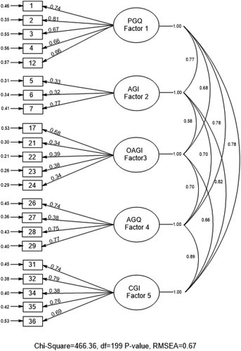
In the scale, the relationship between the factors was examined and the correlation coefficients showing this relationship are given in .
Table 5. The correlation coefficients between the sub factors.
shows that the correlations between the sub-factors of the scale vary between 0.509 and 0.888. These values indicate that the five factors have positively significant and medium or high correlations at p < .01 levels with each other.
In consequence, when the findings obtained from the CFA were assessed as a whole, it is possible to argue that the assessment tool has acceptable goodness of fit in general and applicable.
Findings on the reliability
Firstly, the reliability coefficient of Cr α was calculated regarding the reliability. Also, item-total correlations of the items in the scale were examined. In this context, the reliability values of the groups on which both EFA and CFA were conducted and the item-total correlation values are given in , respectively.
Table 6. Reliability coefficients.
Table 7. Means and standard deviations of the items, total correlations of the items, and cronbach alpha coefficient.
The Cr α value of the whole scale was found to be 0.926 and 0.950. As the Cr coefficient approaches 1, it is concluded that the internal consistency of the items in the scale is high and it is desired to approach 1.00 as much as possible (Erkuş, Citation2017). In this respect, regarding , it can be stated that the scale and its sub-factors have very high internal consistencies.
The correlations between the item-total test scores, used to distinguish between the individuals in terms of the measured characteristic, vary between 0.540 and 0.655. 0.30 or higher item-total correlations are used as a proof for the validity of the items of the scale (Büyüköztürk, Citation2012). These values show that the validities of the items are high.
In order to determine whether each item of the scale is discriminative or not, differences between the mean scores of the 27% lower and 27% upper groups were examined by performing an independent sample t-test.
The values obtained from the item analysis performed for the lower and upper groups of the scale are given in .
shows that the values of the independent samples t-test performed on the differences between the item scores of the 27% lower and upper groups of the scale varied between 9.879 and 12.622 and were significant at P < .01 level. Mean item scores vary between the lowest 2.12 for the lower groups and the highest 4.64 for the upper groups. As also Özgüven (Citation2011) stated, as the contrast between the mean item scores of these groups taken from the two ends of the distribution increases, the discrimination becomes more accurate. Based on these findings, it is possible to say that the scale has high accuracy and is discriminative.
Table 8. The t values for the 27% lower and upper groups of the item analysis of the scale.
Conclusion and recommendations
One of the purposes of the geography education today is to raise students as individuals who can find solutions to the problems and cases around them and are equipped with the skills and competencies of the 21st century. Among these skills and competencies, inquiry skill plays an important role in students’ learning geographic thinking styles, being educated as geographically literate individuals, and gaining the other geographic skills. Geographic inquiry, which forms the basis of geographic literacy, is about students’ asking geographic questions, interpreting the information by investigating the answers to these questions, and revealing their conclusions. Assessment and evaluation techniques are needed to determine the inquiry skills gained by students in educational environments.
However, when it comes to the practices that are carried out, assessment and evaluation activities conducted at schools are not performed to support the education effectively, instead, it is observed that it is for measuring to what extent the information conveyed by the teacher was learned by the student. Similar to this situation in Turkey; Edelson et al. (Citation2013) stated that evaluation in the geography education is conducted for measuring the knowledge, while the skills are not widely evaluated.
In reviewing the literature, we saw that the lack of assessing skills in geography education is a general trend. As in the other skills in geography, we noted that the studies on geographic inquiry lack assessment of skills.
In light of these considerations, it is necessary to develop fit-for-purpose and reliable measurement tools to be able to evaluate students in geography education and use the developed measurement tools in studies based on various applications in geography education. In order to address this need, the Geographic Inquiry Process Skills Scale was developed in order to evaluate the geographic inquiry skills of 9th – 12th-grade students. During the scale development phase, the steps in A Road Map for 21st Century Geography Education (Citation2013) and GENIP (Citation2012) were taken as reference. In addition to these two sources, geography curricula of various countries and the literature were used in writing the scale items. The GIPSS consisted of five sub-factors following EFA and CFA. Organising Geographic Information and Analysing Geographic Information steps, found in the GIPSS trial form, were combined as a single factor. This is thought to be because the step of analysing geographic information in the geographic inquiry has many overlapping points with the steps of acquiring geographic information and organising geographic information (GENIP, Citation2012; Kidman & Casinader, Citation2017). These five factors in the assessment tool were named Posing Geographic Questions, Acquiring Geographic Information, Organising and Analysing Geographic Information, Answering Geographic Questions, and Communicating Geographic Information in accordance with the literature. The variance ratio that the scale accounts for is 65.204% in total. The internal consistency coefficient was found to be 0.926 for the whole scale and 0.778, 0.814, 0.896, 0.841, and 0.821 for the sub-factors, respectively. 22-item structure, consisting of five factors and formed through EFA, was confirmed in consequence of CFA. Goodness-of-fit indices (RMSEA, GFI, AGFI, SRMR, NFI, CFI), obtained in consequence of the confirmatory factor analysis, were examined and the structure was found to have acceptable goodness-of-fit measures. It was found that the items in the scale had the power to both assess the characteristic they wanted to assess and distinguish between the students who had the desired characteristic and who did not. Based on these results, it can be said that the scale is valid and reliable. As a result of this study, a valid and reliable assessment tool, which can be used to measure the geographic inquiry process skills of 9th – 12th-grade students, was developed.
It is thought that the GIPSS will help teachers to create inquiry plans or revise existing plans according to the amount of support he/she will provide to students, the level and the need of the students, determine the method and technique he/she will use to gain the skills, prepare the environment appropriate for this method and technique, detect the time spent during the application, and determine the material to be used according to the status of students. Also, the scale will be effective in allowing a student to become aware of his/her strengths and weaknesses and evaluating himself/herself.
Two suggestions are offered about the scale in consequence of this study. The first one is the use of the GIPSS for the purposes such as monitoring the improvement and progress in the inquiry skills of students from different types of schools and grade levels, identifying their levels, and determining deficiencies in their learning. The second one is re-testing the validity and reliability study of the GIPSS on different student groups, as it is the first study in the field.
Disclosure statement
No potential conflict of interest was reported by the authors.
Additional information
Notes on contributors
Hülya Yiğit Özüdoğru
Hülya Yiğit Özüdoğru is a lecturer at Ankara Hacı Bayram Veli University, Turkey. Her research interests are focused on human geography and geography education. Her research focus lies at the history of education programs, social policy in education, inclusive education, migration and Syrian refugees, and evaluation in education.
Nurcan Demiralp
Nurcan Demiralpis an Associate Professor at the Department of Geography Education, Gazi University, Turkey. Demiralp’s research interests are focused on geography education. Her research focus lies at the geography skill, between the curriculum development, assessment and the professional development for educator preparation.
References
- Australian Curriculum, Assessment and Reporting Authority [ACARA]. (2017). Australian Curriculum. Retrieved from https://www.australiancurriculum.edu.au/
- Büyüköztürk, Ş. (2012). Sosyal bilimler için veri analizi el kitabı (12. baskı.). Ankara: Pegem Akademi.
- Edelson, D. C., Gordin, D. N., & Pea, R. D. (1999). Addressing the challenges of inquiry-based learning through technology and curriculum design. Journal of the Learning Sciences, 8(3–4), 391–450.
- Edelson, D. C., Shavelson, R. J., & Wertheim, J. A. (Eds.). (2013). ARoad map for 21st century geography education: Assessment (A report from the Assessment Committee of the Road Map for 21st Century Geography Education Project). Washington DC: National Geographic Society.
- Education Bureau (EDB, 2017). Curriculum documents. Retrieved from https://www.edb.gov.hk/en/curriculumdevelopment/kla/pshe/curriculum-documents.html#3217
- Engel, K. S., Moosbrugger, H., & Müller, H. (2003). Evaluating the fit of structural equation models: Tests of significance and descriptive goodness of fit measures. Methods of Psychological Research Online, 8(2), 23–74.
- Erkuş, A. (2017). Psikolojide ölçme ve ölçek geliştirme-II: Ölçme araçlarının psikometrik nitelikleri ve ölçme kuramları. Ankara: Pegem Akademi Yayıncılık.
- Geography Education National Implementation Project [GENIP]. (2012). Geography for life: National Geography Standards 2012, ( 2nd ed.). Washington, DC: National Council For Geographic Education.
- Hmelo, C. E., Duncan, R., & Chinn, C. A. (2007). Scaffolding and achievement in problem-based and inquiry learning: A response to Kirschner, Sweller, and Clark (2006). Educational Psychologist, (42), 99–107. doi:https://doi.org/10.1080/00461520701263368
- Kan, A. (2014). Albert Bandura ve sosyal öğrenme kuramı. In S. B. Filiz(Ed.), öğrenme öğretme kuram ve yaklaşımları (pp.76–95). Ankara: Pegem Akademi.
- Karabağ, S. (1998). Coğrafya öğretiminde anahtar sorular ve kavramlar. Gazi Eğitim Fakültesi Dergisi, 18(2), 25–41.
- Kidman, N., & Casinader, G. (2017). Inquiry-based teaching and learning across disciplines comparative theory and practice in schools. Basingstoke, England: Palgrave Macmillan.
- Milli Eğitim Bakanlığı (MEB). (2005). Coğrafya dersi öğretim programı. Ankara: Milli Eğitim Basımevi.
- Milli Eğitim Bakanlığı (MEB). (2018). Coğrafya dersi öğretim programı. Retrieved from http://mufredat.meb.gov.tr/ProgramDetay.aspx?PID=336.
- Özgüven, İ. E. (2011). Psikolojik testler. Ankara: Pdrem Yayınları.
- Ministry of Education Singapore (MoE). (2013). Geography. Retrieved from https://www.moe.gov.sg/education/syllabuses/humanities/2018
- Ontario Ministry of Education (OC). (2018). Ontario curriculum. Retrieved from http://www.edu.gov.on.ca/eng/curriculum/secondary/ssciences.html
- Qualifications and Curriculum Authority. (QCA). (2004). Archive - National Curriculum handbook for secondary teachers in England (revised 2004). Retrieved from https://webarchive.nationalarchives.gov.uk/20130401042742/https://www.education.gov.uk/publications/standard/publicationDetail/Page1/QCA/04/1374
- Rawling, E. (2000). The geography national curriculum: What’s new? Teaching Geography, 25(3), 119–122.
- Roberts, M. (2003). Learning through enquiry. Making sense of geography in the key stage 3. UK: Geograpical Association.
- Roberts, M. (2013). Geography through enquiry. Sheffield: Geograpical Association.
- Schell, E. M., Roth, K. J., & Mohan, A. (Eds.). (2013). A road map for 21st century geography education: Geography education research (A report from the Geography Education Research). Road Map for 21st Century Geography Education Instructional Materials and Professional Development. Washington, DC: National Geographic Society.
- Singapore Examinations and Assessment Board. (SEAB). (2018). Examinations. Retrieved from https://www.seab.gov.sg/
- Slater, F. (1982, April 16–20). What geography education for 16–19 years old an outline geograpy education 16–19 project. New Zeland Journal of Geography, April, 16-20.
- Spronken-Smith, R., Bullard, J., Ray, W., Roberts, C., & Keiffer, A. (2008). Where might sand dunes be on Mars? Engaging students through inquiry-based learning in geography. Journal of Geography in Higher Education, 32(1), 71–86.
- Vajoczki, S., Watt, S., Vine, M. M., & Liao, R. (2011). Inquiry learning: Level, discipline, class size, what matters? International Journal for the Scholarship of Teaching and Learning, 5(1), 1-13.
Appendix A.
Geographic Inquiry Process Skills Scale
We prepared this study to determine the Geographic Inquiry Process Skills of 9–12th grade students. The steps of the geographic inquiry process are posing geographic questions, acquiring information, organising information, analysing information, answering questions, and communicating the answers of the questions, respectively. Below you will find some sentences about this process. First, carefully read the steps section step by step. After you read each step, proceed to the statements section next to each step. Then read also these statements carefully and mark how often you are able to perform the option that suits you best. Then proceed to the next step below.